
ABSTRACT
The Glenorchy area of northwest Otago consists of a low-relief Holocene fluvial delta complex below glaciated mountains of Otago Schist basement, and has locally elevated arsenic (As) from two geogenic pathways: Mesozoic hydrothermal processes and Holocene shallow groundwater transport. Soils on the delta complex are primitive and contain abundant sand and silt derived from unoxidised schist basement, with background As contents generally <30 mg/kg. Some soils in wetland areas on the delta have naturally elevated (geogenic) arsenic contents that are locally >300 mg/kg on the cm2 scale. Arsenic enrichment has occurred in the upper 30 cm where dissolved As and Fe from low-redox chemical conditions in shallow groundwater has become oxidised, thereby lowering their solubility. Both As and Fe are being mobilised from background sulfide minerals in schist-derived debris, and groundwater As concentrations up to 0.8 mg/L have been recorded. Historic mining of scheelite for tungsten on the surrounding mountains has exposed small volumes (typically tens to hundreds of m3) of arsenopyrite-bearing mine wastes with spot As contents from <500 to >10 000 mg/kg. Water discharging from mine adits have pH∼8 and dissolved As up to 0.3 mg/L, but these waters are rapidly diluted downstream to <0.02 mg/L.
Introduction
Mobilisation and concentration of geological sources of arsenic (As) in the surficial environment is a global issue that is attracting increasing attention, especially where these processes occur in human contexts (Nickson et al. Citation2000; Morin and Calas Citation2006; Polizzotto et al. Citation2008; Podgorski and Berg Citation2020). There are two principal geological pathways involved in creating localised elevated surficial As concentrations: dissolution of sulfidic mineralised rocks, especially around gold mines; and shallow groundwater mobilisation in sediments (Nickson et al. Citation2000; Morin and Calas Citation2006; Polizzotto et al. Citation2008; Lottermoser Citation2010; Podgorski and Berg Citation2020). Mine-related As is a well-known phenomenon and As management is a routine aspect of modern mine management (Lottermoser Citation2010; Bowell and Craw Citation2014; Craw and Bowell Citation2014). Groundwater-related As enrichment situations were initially identified in Bangladesh in the 1990s, where low levels of As affected up to 50 million people (Nickson et al. Citation2000; Polizzotto et al. Citation2008; Podgorski and Berg Citation2020; Shaji et al. Citation2021). Similar groundwater issues have since been identified around the world, and identification, management, and treatment of As-bearing groundwater is a subject of much on-going research as the numbers of people affected are large (possibly hundreds of millions; Rowland et al. Citation2011; Smedley and Kinniburgh Citation2013; Robles et al. Citation2016; Podgorski and Berg Citation2020; Stopelli et al. Citation2020; Shaji et al. Citation2021).
In New Zealand, mine-related As is well-known because of the widespread occurrences and historic development, of gold mines in basement rocks, especially in Coromandel, Westland, and Otago (Haffert et al. Citation2010; Craw and Bowell Citation2014; Craw and Pope Citation2017; Kerr et al. Citation2018; Weightman et al. Citation2022). In contrast, the phenomena of groundwater As mobilisation and surficial concentration have been less studied, although As dissolved in drinking water is receiving more attention with increased scrutiny of domestic water quality (ORC Citation2021; Shaji et al. Citation2021), with a recommended drinking water upper limit for As of 0.01 mg/L (WHO Citation2022). Similarly, more recent attention has been paid to elevated As in soils, especially where those soils are associated with domestic dwellings (e.g. QLDC Citation2016). This has been done in the context of the recommended upper limit for As in soils, for residential areas with small gardens, that has decreased to only 20 mg/kg (MfE Citation2011), close to the background level in some ordinary rocks (Blake et al. Citation2019).
In this study, we investigate the distribution of As in the surficial environment around the town of Glenorchy, at the foot of the Southern Alps mountains of NW Otago (A,B), in the context of inferred geological processes. This area is useful for this type of study because there has been an extensive history of mining of As-bearing rocks on the slopes above the town (B). In addition, the town itself is located on a river delta (B) that is affected by shallow groundwater in fresh sedimentary rocks that contain low but important levels of background As that are available for near-surface mobilisation. Hence, the area provides an ideal setting for comparison of the two principal pathways for As mobilisation in a New Zealand mountain context. This study is also intended to provide some context for a well-defined area of surficial As enrichment at Frankton, a suburb of Queenstown (A; A–E; QLDC Citation2016). In the Frankton situation, the area has been extensively modified by urban development so details of the geological setting have been lost. Glenorchy area is underlain by essentially identical basement and sediments and therefore provides a useful proxy for understanding the Frankton situation.
Figure 1. Location maps for this study (A) Location in the Otago Schist belt. (B) Hillshade digital elevation model (DEM) image of the Glenorchy area, showing topography, drainage, and locations of principal mined areas (size exaggerated for clarity). Summary As concentrations in water, rocks and soils are indicated (see text for references).
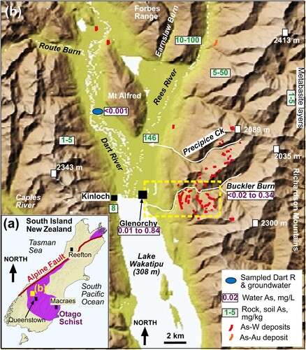
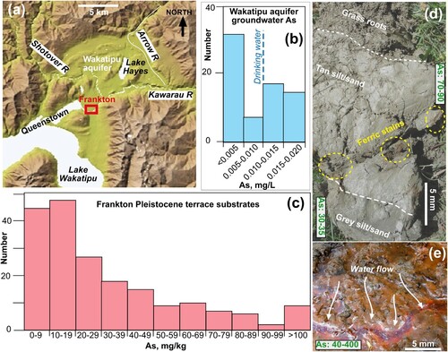
Figure 2. Summary of features in the Frankton area relevant to As mobility and enrichment. (A) DEM of the Queenstown district, showing general location of Wakatipu shallow groundwater aquifer (Rosen and Jones Citation1998) and Frankton. (B) As concentrations in Wakatipu aquifer groundwaters, summarised from ORC (Citation2021). (C) As concentrations in Frankton substrates, summarised from QLDC(2016). (D) Photograph of excavated section through substrate near top of Frankton terrace, with summary of fp-XRF As analyses (mg/kg) at different levels. (E) Active deposition of ferric oxyhydroxide, with adsorbed As (mg/kg; fp-XRF analysis summary), from groundwater seep at bottom of Frankton terrace.
General setting
Basement rocks
The Glenorchy area is underlain by Mesozoic Otago Schist basement, mostly of Caples Terrane with Aspiring Terrane rocks exposed on the upper parts of the Richardson Range (A,B; Craw Citation1984; Turnbull Citation2000). There is a metamorphic transition from sub-greenschist facies greywacke, argillite and weakly foliated schists on the western side of Lake Wakatipu and lower Dart River valley, to lower greenschist facies schists in the Rees River valley and upper greenschist facies rocks near the top of the Richardson Range (B; Paterson Citation1982; Craw Citation1984; Turnbull Citation2000). The Forbes Range and nearby Mt Alfred (B) are underlain by sub-greenschist facies schists that are mostly pelitic and are locally highly micaceous and foliated but only weakly segregated metamorphically (Craw Citation1984). In contrast, rocks on the Richardson Range are interlayered psammitic and pelitic schists with extensive metamorphic foliation and segregation. All the metasedimentary schists of the area have similar quartzofeldspathic compositions, although there are subtle geochemical differences between Caples Terrane and Aspiring Terrane rocks (Palmer et al. Citation1991; Mortimer and Roser Citation1992). Metabasic schist horizons are rare except in Aspiring Terrane rocks high on the Richardson Range (B; Craw Citation1984; Turnbull Citation2000).
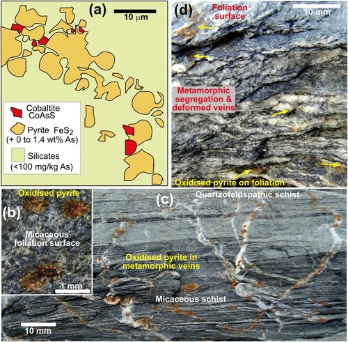
Background As concentrations in Otago Schists and their precursor metasediments are typically between 1 and 30 mg/kg when measured in bulk hand specimens (Palmer et al. Citation1991; Pitcairn et al. Citation2006; Citation2010). This range of As contents is typical of bulk samples of quartzofeldspathic metasediments in the South Island in general (Hamisi et al. Citation2017). Similar background levels of As occur in schist-derived loess and colluvium in eastern Otago near the Macraes gold mine, as measured with field-portable X-ray fluorescence (fp-XRF; A,B; Blake et al. Citation2019). Arsenic is inhomogeneosly distributed within the Otago Schist rocks themselves, and it occurs principally within trace amounts of sulfide minerals (A; Pitcairn et al. Citation2010; Large et al. Citation2012; Hu et al. Citation2016). In particular, As is present at low levels (∼1 wt%) in solid solution in pyrite, and in ultra-trace amounts of cobaltite (CoAsS; A; Pitcairn et al. Citation2006, Citation2010; Hu et al. Citation2016). Similarly, these sulfidic As hosts are typical of South Island quartzofeldspathic metasediments in general (Pitcairn et al. Citation2010; Hamisi et al. Citation2017).
Figure 3. Validation and calibration of fp-XRF analysis; see text for references. (A) Background As and Fe concentrations in Otago Schist and schist-derived colluvium near Macraes in east Otago (A). (B) Calibration over 5 orders of magnitide of fp-XRF As analyses compared to lab-derived XRF data for same dried samples.
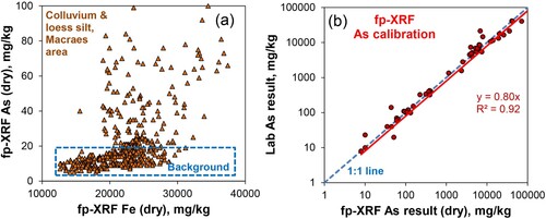
Figure 4. Typical mineralogical and textural distribution of As-bearing sulfides in schist samples relevant to this study. (A) Sketch of pyrite and cobaltite in sub-greenschist Caples Terrane rock (after Pitcairn et al. Citation2010). (B) Close view of foliation surface of a sub-greenschist facies pelitic schist from an outcrop in Forbes Range (OU 42272). Brown spots indicate incipient oxidation of pyrite within the foliation. (C) Cobble of Forbes Range sub-greenschist facies schist from Earnslaw Burn, showing oxidation spots for pyrite in cross-cutting metamorphic quartz veins. (D) Broken section through a cobble of well-segregated greenschist facies schist from Richardson Range. Brown spots (yellow arrows) indicate pyrite oxidation on foliation, and in foliation-parallel deformed quartz veins (top).
A prominent swarm of hydrothermal vein systems was emplaced in the schists of the Richardson Range in the Cretaceous, and some minor veins occur distributed sparsely farther to the northwest (B; Williams Citation1974; Paterson Citation1982; Mortensen et al. Citation2010). Many of these veins systems were mined historically for scheelite (CaWO4), with some mining continuing to the 1970s (Williams Citation1974). Gold is locally anomalous in the veins, but gold was mined from only one principal vein system in the lower Rees valley (Williams Citation1974; Hay and Craw Citation1993). All the vein systems contain arsenopyrite and pyrite (Paterson Citation1982; Mortensen et al. Citation2010). The mineralised rocks are broadly coeval with similar Au-W-As rocks at the Macraes mine in eastern Otago (A; Mortensen et al. Citation2010; MacKenzie et al. Citation2017), and data from the modern Macraes mine are incorporated in this study for comparison.
Surficial setting
The studied area lies on the eastern side of the Southern Alps mountains that are rising in the hanging wall of the Alpine Fault (A). The town of Glenorchy lies on a fluvial delta complex formed by coalescence of outwash from the Dart and Rees Rivers and the Earnslaw Burn (B). The area was extensively glaciated during the Pleistocene, with ∼1 km thick ice extending from the mountains southwards down Lake Wakatipu (B; Turnbull Citation2000), and some high cirque glaciers have persisted to the present. Lake Wakatipu was higher than present during early Holocene deglaciation, and left a silt-dominated bench in some places at ∼50 m above present level at ∼12 ka (Turnbull Citation2000), although that sediment has since been mostly eroded from the Glenorchy delta. Glaciation has ensured that most rock outcrops are either unoxidised or only weakly oxidised, and sediments carried by the rivers are largely unoxidised as well. Steep stream channels carry abundant coarse gravel eroded from valley walls, and these have formed gravel-rich alluvial fans, some of which extend onto the delta to join the main rivers.
The delta is an area of low relief with a water table close to the surface in many places. There are extensive areas of wetlands adjacent to the main river channels, and some streams emanating from valley walls meander across the delta plain (B). Gravel channel margins are dominated by fine sediment, especially silt and sand deposits derived from glacial flour. Wind-blown silt from river flats farther upstream is a frequent component of the modern environment, and associated loess deposits cover the surface and are interbedded with underlying fluvial sediments.
The climate of the Glenorchy delta is cool temperate, with mean annual temperature of ∼10°C, some cold winter nights (−5°C) and some hot (>30°C) summer days (NIWA Citation2021). Annual rainfall is ∼1000 mm spread throughout the year, but rainfall on the delta can be highly variable on the km scale as rain events are localised by the mountain topography, especially via channelling of northwest storms down the Dart valley. Strong winds, rain, and surface flooding associated with these storms in particular are responsible for frequently redistributing loess on parts of the delta.
Methods
Analyses of solid materials in this study were obtained with fp-XRF, with focus on As and Fe contents. An Innov-X Model Omega instrument was used for analysing mine-related As contents in the Buckler Burn catchment (B). This instrument had a practical detection limit for As of ∼50 mg/kg. A newer Olympus Vanta M Series fp-XRF instrument was used for all other analyses. Practical detection limit for this instrument is 3–5 mg/kg, and results are reproducible to ±2 mg/kg at 10 mg/kg, as calibrated by Blake et al. (Citation2019). The instruments have been calibrated for a wide range of As concentrations in a range of studies of surface As distribution, and combined calibrations over several orders of magnitude relevant to the present study are presented in (B) (Druzbicka and Craw Citation2015; Malloch and Craw Citation2017; McLachlan and Craw Citation2018; Blake et al. Citation2019). In general, fp-XRF tends to over-estimate As concentrations at high As levels by up to 20% (B), but Blake et al. (Citation2019) found a strong agreement between the Olympus fp-XRF and laboratory results at low As levels. On the other hand, analysis of damp materials in situ in the field, as done for some of this study, can lead to under-estimation of As concentrations in relation to the dry materials used in calibration (B). The device analyses an area of ∼1 cm2 with limited depth penetration (mm scale), so analyses are essentially of surfaces rather than volumes. The schist basement rocks are inherently inhomogeneous at this scale (B–D), so multiple analyses were obtained. Because of these uncertainties, we report herein only raw fp-XRF data for As and Fe. For the purposes of this study, it is the relative values of As and Fe determined within the Glenorchy area and elsewhere that are most important.
Two unpublished soil analyses, from Kinloch and Glenorchy areas (B; ) provide confidence in the relative differences in results for the fp-XRF instrument. These soil heavy metal analyses were determined from bulked composites of >10 soil subsamples that were dried and <2 mm fractions were digested with nitric and hydrochloric acid (USEPA 200.2) and analysed by ICP-MS at Hill-Labs (Hamilton, NZ), an internationally accredited laboratory. Surface substrate As analyses at Frankton (C) have been compiled from Queenstown-Lakes District Council data (QLDC Citation2016). These are compared in to typical schist rock data (Paterson and Rankin Citation1979; Palmer et al. Citation1991; Craw Citation2002).
Table 1. Arsenic and metal concentrations (mg/kg) in soils and rocks relevant to this study.
Field pH measurements of surface waters were determined with an Oakton PC450 metre calibrated daily with standard solutions (pH 4,7,10). Water samples in the Buckler Burn catchment (B; ) were collected in acid-washed plastic bottles and stored with ice until analysis at Hill-Labs in Hamilton. Filtered samples (0.45 µm) for metal analysis were preserved with nitric acid in the field, and analysed by APHA (Citation2005) method 3125 B, with detection limit of 0.02 mg/L for As. Standard methods (APHA Citation2005) were used for major ions after 0.45 µm filtration in the lab: Method 311 IB was used for Ca, Mg, Na and K, Method 4500C1 used for chloride, and Method 2320B used for dissolved carbonate (alkalinity titration), sulfate was determined by ion chromatography (Method 4110B). Unpublished analyses of Dart River surface and shallow groundwater () were obtained from a commercial organisation and are used here for background comparison, along with data from Rosen and Jones (Citation1998) for major ions in the Wakatipu aquifer near Queenstown (A; A). Arsenic analyses of shallow groundwaters at Glenorchy (b) and in the Wakatipu aquifer (B) have been compiled from Otago Regional Council data (ORC Citation2021).
Table 2. Water analyses for the Buckler Burn catchment (a) compared to Dart River background.
Results
Arsenic in background rocks and sediments
Silt deposits are exposed in the open river beds of the Glenorchy delta area after flood events and wind-storms. These sediments mostly have background levels of As (<30 mg/kg; A). The As concentrations are variable (4–45 mg/kg; A), reflecting the inhomogeneity of the source areas and vagaries of sedimentary deposition. However, these As concentrations are typical for bulk analyses of Otago Schist rocks (e.g. ). A selection of rocks from outcrops in the Forbes and Richardson Ranges and from river beds emanating from those ranges, analysed with fp-XRF, shows a much wider range of As concentrations than the sediments, up to 190 mg/kg (B). The highest As concentrations (>100 mg/kg) were measured on rocks collected at outcrops in those ranges (C,D), and these higher concentrations were obtained on micaceous foliation surfaces (e.g.; B). Of these higher concentrations, most were obtained from micaceous (pelitic) schists of the Forbes Range (C). Rocks in river beds have been extensively abraded during transport, and have abundant erosion-resistant quartzofelspathic segregations and/or quartz veins exposed on exterior surfaces (e.g. C,D). Consequently, the As concentrations measured on the surfaces of these rocks were generally lower (<50 mg/kg) than those from outcrops (B).
Figure 5. Arsenic and Fe analyses (fp-XRF) of solid materials on Glenorchy delta and nearby mountains. (A) Sandy silt from exposed portions of active river beds, and soil on fans near Kinloch (B). (B). Rocks from Forbes and Richardson Ranges, from outcrop and stream cobbles. Several analyses were done on different surfaces of some rocks. (C) Analyses as in b for rocks from outcrops on Forbes Range. (D) Analyses as in b for rocks from outcrops on Richardson Range. (E) Analyses of shallow soils (upper 15 cm) from Lower Rees valley on Glenorchy delta (B). Data for deeper soil profiles (as in f) are also plotted. (F) Variations of As with depth for two soil profiles (A–C) in the lower Rees valley, with generalised envelope indicating surface enrichment.
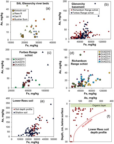
The higher As concentrations generally occur in analyses with higher Fe concentrations, although the data show wide scatter in this regard (A–D). Chlorite and pyrite are the two principal Fe-bearing minerals in these rocks and sediments, and both of these occur within the micaceous laminae (e.g. B). Since pyrite is one of the main hosts of As, and is commonly accompanied by cobaltite (A), the distribution of pyrite has a strong effect on measured As concentrations, and a lesser effect on measured Fe concentrations within a chlorite-rich background. The sulfide minerals are typically fine-grained (micron-scale) in these rocks (A), so surface analyses at the scale of the fp-XRF instrument cannot resolve the sulfide distribution. The locations of pyrite grains, or clusters of grains, are indicated on the surfaces of many rocks by oxidation spots on foliation surfaces and in metamorphic veins (B–D). However, these spots are too small to analyse specifically with the fp-XRF instrument, and none of the highest As concentrations were obtained on these spots.
Arsenic in soils
Soils in the Glenorchy delta area are primitive, as they have been developing on fresh rocks and sediments only since the last glaciation (<20 ka). Further, the delta is a dynamic fluvial environment, so river channel migrations have eroded older surfaces and left newer ones exposed to revegetation. Hence, most soil profiles have a thin (<10 cm) organic-rich layer at the surface, with plant roots extending down into essentially original silt, sand and gravel sediments. There has been minor oxidation of the near-surface portions of some of the soil profiles, but many soils have retained their original grey colour typical of the fresh sediments on the active delta surfaces. The As concentrations of these soils are generally low (<10 mg/kg), reflecting the As concentrations of the original sediments (e.g. Kinloch soils; A).
Soils in the lower Rees valley generally have typical background As concentrations (<30 mg/kg), but there are some areas where the As contents are distinctly higher than these background levels (B; E; ). These higher As concentrations (>50 mg/kg) occur in and near wetlands and meandering low-gradient streams draining across the delta plain (B). Surface waters have pH between 5.6 and 7.2. These soils have higher organic contents than elsewhere, and display greater contrast between an oxidised surface zone and largely unoxidised deeper levels (A–C) than is seen in better-drained and less water-logged environments. The sediments on which these soils have developed are fine-grained (silt and sand), with no gravel components (A–C). Mineralogically, these fine sediments are dominated by micaceous material (muscovite and chlorite; C).
Figure 6. Photographs of soil profiles from lower Rees valley, with As analyses (E,F). (A) Profile with transition from oxidised (brown, top) to low-oxygen (grey, bottom) environments, and summaries of As concentrations (mg/kg). (B) Profile with sharp redox boundary (yellow dashed line) between oxidised (top) and low-oxygen environments, with As spot analyses (mg/kg). (C) Close view of central portion of b, showing patches of ferric staining. White sheen shows prevalent mica flakes.
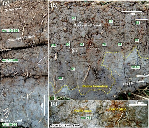
In some of the wetland soil profiles there is a sharp redox boundary between the relatively oxidised surface zone and the unoxidised deeper levels (B), but in most of these soil profiles this change is transitional over ∼30 cm (A). The highest As concentrations occur in the more oxidised upper zones in these soils, and spot analyses as high as 340 mg/kg As were obtained (E; A). The spot As analyses were highly variable within the oxidised surficial layers, but most analyses were higher than background levels seen elsewhere on the delta (E,F; A–C). In contrast, As concentrations of the sediment below the redox boundary or transition were similar to those of the background sediments (E,F; A,B).
There is a crude positive correlation between higher As concentrations and higher Fe concentrations in the wetland soils (E). This correlation is supported by observations of secondary ferric oxyhydroxide staining within the surficial zone (A–C). Direct measurements over the brownest spots yielded As analyses elevated above background, but did not yield the highest As concentrations. Some of the best-developed ferric stains occur around plant rootlets and these zones commonly have cavitation in the soil (C), limiting the effectiveness of fp-XRF analysis. The ∼1 cm2 spatial analytical scale of the fp-XRF instrument is apparently too large to allow better definition of this As-Fe relationship.
Arsenic in mine debris
Scheelite mines in the Glenorchy area (B) were developed on a swarm of hydrothermal quartz veins that are typically 1–2 metres thick, and some veins are traceable around the hillsides for >200 m. On the Richardson Range, the veins have a shallow eastward dip, and the mines followed these structures into the hillsides. The mineralised zones are locally strongly enriched in As, up to ∼10 000 mg/kg (wt % levels). An extensive analytical data set from the active Macraes mine in east Otago (A), which has similar vein systems to Glenorchy, shows that As concentrations are commonly as high as W concentrations in bulk samples (A). However, at more detailed scales of hand specimens and outcrops, scheelite occurs within vein quartz with very low As concentrations (<10 mg/kg), and the As is concentrated on the margins of the veins in arsenopyrite and pyrite (B–D). The As-bearing vein selvedges are only mm- to cm-scale on many veins, although a halo of anomalous As can extend for up to a metre. Some thin (mm-cm) As-bearing seams similar to the vein selvedges occur within veins as well, sub-parallel to the vein margins.
Figure 7. Relations between As and W at mine sites. (A) Bulk analyses of As and W at Macraes mine (MacKenzie et al. Citation2017), paragenetically similar to Glenorchy mineralisation system. (B) Portion of a typical scheelite-bearing vein from Glenorchy, with an As-rich selvedge. (C) Perpendicular view of the As-bearing selvedge in b. A = arsenopyrite. (D) Close view of relatively coarse sulfides in the selvedge in c. A = arsenopyrite; P = pyrite. (E) Glenorchy State mine waste rock pile dominated by unmineralised schist debris. (f) Bonnie Jean mine waste rock pile, with fp-XRFAs analyses. Paler portions are quartz-rich debris.
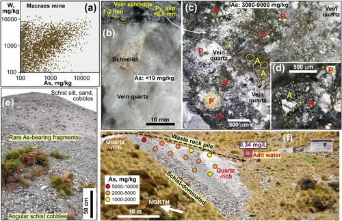
When the Glenorchy veins were mined, the scheelite-bearing quartz was the principal target, but the As-bearing vein margins and some of the unmineralised host rocks were extracted as well. The quartz-rich ore was separated for further processing to concentrate the scheelite, and the rest of the mined material was dumped at mine entrances as waste rock piles (E,F). Waste rock piles remain scattered across the mined landscape, and these are the principal repositories of surface As in the mined areas, especially in the Buckler Burn catchment, where most of the mines were located (B; E,F; A). Some waste rock piles are dominated by unmineralised schist that has only background As concentrations and minor scattered As-bearing cobbles (E). Others have abundant As-bearing material, typically with As concentrations between 2000 and 5000 mg/kg as measured with fp-XRF (e.g.; F). The As-bearing selvedge material (B–D) is friable and has crumbled to fine grained residues (silt, sand, fine gravel) on many of the waste rock piles and locally forms a matrix to the harder unmineralised rocks.
Figure 8. Buckler Burn mine sites. (A) General map of the catchment, showing locations of waste rock piles (summarised from GoogleEarth), and As water concentrations at sampled sites (). (B) Map and As concentrations of tailings pile at the Glenorchy State mine processing plant. (C) Oblique photograph of map view in b. (D) Excavated depression in tailings to reach As-rich material beneath quartz-rich surface.
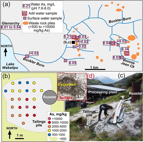
Ore from the mines was processed, mainly by crushing and water-washing, to separate scheelite from quartz. Some of that quartz-rich ore inevitably had As-bearing selvedge material attached, so tailings from processing were As-bearing. These tailings were mostly discharged into the nearest creek, and those tailings have since been washed away during floods. One small tailings deposit remains at the Glenorchy State Mine processing site (A–C). The surface of this tailings pile has developed a relatively low-As quartz-rich armouring layer 1–5 cm thick as a result of rain-washing after the site was abandoned in 1970s (C,D). Arsenic-rich residues persist below this surface layer, with As concentrations up to wt% levels (B–D). The mineralogical form of this As is not known because of its fine grain size and intimate mixing with fine grained silicates.
Water compositions
A set of stream waters in the Buckler Burn catchment was analysed for major ions and dissolved As in this study as representatives of typical hill-slope waters above and within the scheelite mining area (A; A–F; ). Shallow groundwater was analysed from samples taken at mine adit discharge points (F; A; A–F). These water compositions are compared to background Dart River waters sampled on the Glenorchy delta (B; ) and typical Southern Alps rain water (Jacobson et al. Citation2003; A). Shallow groundwater on the Glenorchy delta locally has elevated dissolved As concentrations (up to 0.84 mg/kg; B; ORC Citation2021), and these data provide context for comparison to the dissolved As concentrations of mine-related waters in the nearby Buckler Burn (A).
Figure 9. Chemistry of Buckler Burn waters () compared to other relevant waters (see text for references). (A) Na versus Cl, showing deviation from marine aerosol composition (blue line). (B) Ca versus alkalinity, showing strong relationship between water compositions and calcite dissolution (brown line). (C) Mg versus sulfate, showing deviation to higher sulfatefrom marine aerosol compositions (blue line). (D) Electrical conductivity (EC) versus pH, showing generally higher pH and lower EC in Buckler Burn. (E) Comparison of pH and dissolved As for Buckler Burn and Macraes mine waste rock discharge waters. (F) Comparison of pH and dissolved As for Buckler Burn waters with Macraes mine tailings waters, and waters derived from experimental leaching of arsenopyrite-rich rock (ore from Reefton; a; Kerr et al. Citation2015).
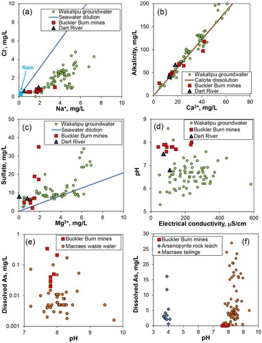
Surface water and shallow groundwater in the Glenorchy area retains remnants of marine aerosols that arrive in rain, so that Na/Cl molar ratio is near to 1:1 (A; ). However, minor water-rock interaction and albite dissolution has raised the Na contents relative to Cl, similar to groundwaters in the nearby Wakatipu aquifer (A; A). Water-rock interaction has also caused calcite dissolution, which controls the Ca:alkalinity ratio close to molar 1:2, as in the Wakatipu aquifer (B). Likewise, oxidation of pyrite (e.g. B–D) has caused some relatively elevated dissolved sulfate concentrations compared to original marine aerosols (C). These water-rock interactions, principally dissolution of calcite, have led to all the Glenorchy waters having neutral-alkaline pH (pH 6.5–8) that is generally higher than most of the waters in the Wakatipu aquifer (D).
The dissolved As concentrations of many Buckler Burn waters associated with mines are higher than the analytical detection limit of 0.02 mg/L (A; E; ). In contrast, stream waters above mines, and the downstream Buckler Burn itself, have dissolved As contents below this detection limit (A;). The highest dissolved As concentrations, up to 0.34 mg/L, are in shallow groundwaters discharging from mine adits (F; A; ). These mine-related dissolved As concentrations in the Buckler Burn are similar to, or slightly higher than, typical Macraes gold mine waste rock waters (E). The Buckler Burn waters are distinctly lower in As concentrations than Macraes mine tailings waters, and experimental leaching waters from arsenopyrite-rich gold ore material (F). The experimental waters also have distinctly lower pH (down to pH 4) than the Buckler Burn waters and Macraes mine tailings (F), reflecting sufide-related acidification that is countered by calcite dissolution in the Buckler Burn (B).
Discussion
Near-surface As mobilisation
The sands and silts that dominate the surficial environment on the Glenorchy delta contain background concentrations of As (typically <30 mg/kg; A,E), and rocks in gravels have similar or slightly higher As concentrations on their exposed surfaces (typically <100 mg/kg; B). The mountain environment, combined with active and recent glaciation ensures that these sediments are unoxidised or only incipiently oxidised, and the As within them is likely to occur predominantly in sulfide minerals and their incipient weathering products (A–D; A). This As is therefore available for mobilisation by shallow groundwater, especially under low-oxygen conditions where As is highly soluble as As3+ complexes (B; Haffert et al. Citation2010; Nordstrom et al. Citation2014; Chi et al. Citation2018). Mobilisation of As in the near-surface environment in this manner is widespread around the world, especially in active orogenic belts where fresh sediments accumulate (Nickson et al. Citation2000; Zheng et al. Citation2004; Chi et al. Citation2018; Stopelli et al. Citation2020; Shaji et al. Citation2021). These As mobilisation processes are particularly effective in water-saturated unconsolidated sediments, especially wetlands, in these tectonic settings (Zheng et al. Citation2004; Polizzotto et al. Citation2008; Podgorski and Berg Citation2020; Shaji et al. Citation2021). In these low-oxygen environments, ferrous iron is also readily mobilised as Fe2+ (B; Zheng et al. Citation2004; Haffert et al. Citation2010; Chi et al. Citation2018).
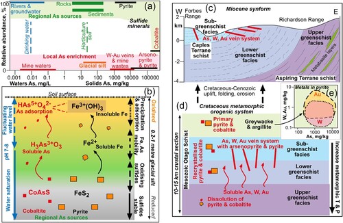
Figure 10. Summary of geogenic As mobilisation and concentration processes relevant to Glenorchy area. (A) Comparisons of principal As concentrations in solid materials, and their relative proportions, for regional geogenic processes and mine sites. (B) Sketch section through soil and underlying fresh schist-derived sediment, showing the principal variations in oxygen contents that control As and Fe mobility in shallow groundwater. (C) Sketch composite cross section from Richardson Range to Forbes Range, showing the present geological structure, with mineralised veins cutting a Mesozoic metamorphic transition that was subsequently folded into a synform in the Miocene. (D) Reconstruction of a Mesozoic crustal metamorphic section, showing Cretaceous mineralisation processes. (E) Arsenic, Au and W in sub-greenschist facies pyrite in the Otago Schist belt that is a precursor to the mineralisation system (Large et al. Citation2012).
Once the As has been mobilised as As3+, it can migrate in groundwater through the hosting sediments, and this is the principal form in which elevated As occurs in domestic water supplies around the world (Nickson et al. Citation2000; Zheng et al. Citation2004; Smedley and Kinniburgh Citation2013; Chi et al. Citation2018; Stopelli et al. Citation2020; Shaji et al. Citation2021). This is the probable source of elevated dissolved As in the Glenorchy area (B; ORC Citation2021). However, if the dissolved As rises into more oxidised near-surface zones, including the soil, As3+ is rapidly oxidised to form As5+ complexes, and Fe2+ is oxidised to form insoluble ferric oxyhydroxide precipitates (B; Nickson et al. Citation2000; Zheng et al. Citation2004; Haffert et al. Citation2010; Campbell and Nordstrom Citation2014; Fresno et al. Citation2016). The ferric oxyhydroxides are effective at immobilising As via adsorption, resulting in near-surface localised As enrichment (B; Gao et al. Citation2006; Zhao et al. Citation2011; Qi and Pichler Citation2016; Chi et al. Citation2018).
The generalised positive correlation between Fe and As in As-enriched soils on the Glenorchy delta (E,F; A–C) reflects this adsorption of mobilised, then oxidised, As in sediments near wetlands (B). The As enrichment of the oxidised zone occurs at a small scale (<1 m depth; B), and can be as narrow as 20 cm (B). At greater depths, water-saturated sediments likely have low-oxygen conditions across the delta. Hence, near-surface As mobilisation, and localised As enrichment of soils on the Glenorchy delta, are results of regional-scale (tens of km2) near-surface dissolution, and minor re-deposition, of trace amounts of As that occurs in all the rocks and sediments (A). This As is ultimately derived from the sulfide minerals, especially pyrite, dispersed throughout these rocks (A,B).
Arsenic at mine sites
In contrast to the regional scale and diffuse sources of As mobility described above, Glenorchy mine sites have much higher As concentrations in much more focused structures (B; B–D; A,C). The high concentrations of As (up to wt% level) have been focused into relatively small volumes, typically only tens to hundreds of m3, of rocks in surface piles and underground mineralised zones (B; E,F; A; A). Most of the As occurs in arsenopyrite (C,D; A), which readily oxidises in wet surficial environments (Craw and Bowell Citation2014; Kerr et al. Citation2015; Blake et al. Citation2019). Minor As in hydrothermal pyrite can also be released by near-surface oxidation (Craw and Bowell Citation2014). Potential for dissolution of As from the mineralogically uncharacterised processing tailings (B–D) has not been determined, but the volume of these residues is small.
Dissolved As has been mobilised in surface and shallow groundwaters related to mine wastes and underground mine workings in the Buckler Burn (A). However, our water analyses indicate that this mobilisation is currently relatively minor, apart from mine waters emanating from underground tunnels (A; ). Even the highest dissolved As in analysed water, 0.34 mg/L, discharging from the Bonnie Jean underground mine (F; A; ) is lower than the highest groundwater As concentration measured in Glenorchy town (0.84 mg/L; B; A; ORC Citation2021). Notably, all the waters with elevated dissolved As from the Buckler Burn mines have been diluted by other runoff in the catchment and the lower Buckler Burn waters have dissolved As <0.02 mg/L (A; ). Silt and sand on the lower Buckler Burn delta has slightly higher As concentrations than other delta river beds (A) but within the range of typical Richardson Range rocks (B). It is possible that there is a component of mine-related debris in these Buckler Burn sediments but if so, it is only trace amounts.
The Glenorchy scheelite mines were developed on a swarm of veins that was originally formed by similar processes to the regional-scale As mobility described above for the Glenorchy delta, but at higher temperatures and greater depths (C,D). Like the regional-scale near-surface As mobility in groundwater, the scheelite-bearing veins derived their metals and As from the dispersed sulfide minerals, including pyrite and cobaltite, in the schist host rocks (D,E; Pitcairn et al. Citation2006; Citation2010; Large et al. Citation2012; Hu et al. Citation2016). The tungsten pathway was more complex than depicted in D,E (Cave et al. Citation2017; Palmer et al. Citation2022) but the overall principles were similar. In this mineralisation process, As migration occurred on a vertical scale of kilometres in shears and fault zones, rather than a horizontal scale of kilometres in fractured bedrock and sedimentary aquifers of the modern Glenorchy delta environment.
Comparison of Glenorchy and Frankton
Surface As enrichment at Frankton occurs on a terrace 20–30 m above the Kawarau River where the river drains from Lake Wakatipu (A,C). The terrace is underlain by schist basement and has a surface cover, up to 10 m thick, of well-bedded sands, silts and muds (D) that were deposited during the early Holocene lake high-stand (Turnbull Citation2000), and are mineralogically identical to those of the Glenorchy delta, including the high mica content (cf C). The sediments were primarily derived from the schist basement in the Wakatipu catchment, although some of the sediment may have been derived from the nearby Shotover River as well (A). Minor gold mining in As-bearing vein systems occurred in the Shotover catchment, > 40 km to the north, but the As signal from mining residues is small and detectable only for ∼2 km downstream (Haffert and Craw Citation2010).
Downcutting by the Kawarau River has left the Frankton terrace unsaturated, with a dry surface, and near-surface sediments are weakly oxidised to a pale tan colour with minor staining by ferric oxyhydroxides (D). At depth, the Frankton sediments are still grey and unoxidised, and the redox boundary is locally sharp (D; cf B) but is mostly transitional over >1 m. The oxidised surficial zone of the sediments on the Frankton terrace has minor elevated As (<200 mg/kg) in an area of ∼0.5 km2 (C,D; QLDC Citation2016). The unoxidised sediments below the redox transition have lower As concentrations (e.g.; 30–35 mg/kg; D), close to typical background levels for these sediments on the Glenorchy delta (A). Most of the present terrace surface sediments have As concentrations below 20 mg/kg (C QLDC Citation2016), but the geological setting of those sediments has now been obscured by urban development.
A groundwater seep at river level below the terrace is actively depositing a mm-thick layer of ferric oxyhydroxide on the surface of an organic-rich wetland, and this ferric oxyhydroxide has adsorbed As up to 400 mg/kg (E). Groundwater in the nearby Wakatipu aquifer has dissolved As near to, and locally exceeding, 0.01 mg/L (B; ORC Citation2021). Water of this type flowing beneath the Frankton terrace is the probable source for the elevated adsorbed As in the wetland, as well as the dissolved ferrous iron to make the ferric oxyhydroxide at the discharge point (E; cf Zheng et al. Citation2004; Haffert et al. Citation2010; Fresno et al. Citation2016). The As mobilisation and enrichment features at Frankton are essentially the same as those observed on the Glenorchy delta, although the Frankton site has more relief. These chemical processes are probably still active in the near-surface Glenorchy sediments and soils, whereas As enrichment of the Frankton terrace sediments has ceased since the sediments became unsaturated, and the active processes are now confined to lower levels below the Frankton terrace surface.
Conclusions
The Glenorchy area has locally elevated arsenic (As) derived from two geogenic pathways. The most widespread pathway involves Holocene shallow groundwater processes in schist-derived sediments on the low-lying fluvial delta (A,B). Trace amounts of As are leached from sulfide minerals, transported in shallow anoxic groundwater as As3+ complexes, and some of that As becomes locally enriched in surficial oxidised zones, probably via adsorption as As5+ complexes to ferric oxyhydroxide. Elevated As concentrations, exceeding drinking water standards (>0.01 mg/L), can arise in the shallow groundwater, especially where that groundwater is slow-moving in low-permeability deltaic silts that contain unoxidised sulfide minerals. Measured As concentrations in boreholes in these sediments in Glenorchy town area are up to 80 times higher than recommended drinking water levels (B). Elevated As concentrations in soils can develop above recommended levels (20 mg/kg), principally in the upper few cm of silt-rich sites that are frequently water-saturated.
The other geogenic pathway for As enrichment in the Glenorchy area involved Mesozoic hydrothermal processes to form quartz veins with scheelite (±gold) in schist basement (C,D). These features have been disturbed at the surface by historic mining activity, resulting in small surficial deposits with high As concentrations (locally >10 000 mg/kg) in sulfide-rich rocks (A). Waters discharging from mine adits have pH∼8 and dissolved As up to 0.3 mg/L, and water downstream of waste rock piles has As up to 0.03 mg/L. All these waters are rapidly diluted downstream to <0.02 mg/L in the principal drainage stream, the Buckler Burn (A). The town of Glenorchy receives most of its domestic water supply from boreholes in gravel beside the lower Buckler Burn and this water has As concentrations <0.01 mg/L, compared to the locally high levels in boreholes in the silt-dominated deltaic sediments (B; A).
The spatial distributions of elevated geogenic As concentrations in water and soils in the Glenorchy delta area are as yet poorly defined, but the key features described above may assist in further spatial characterisiation of these issues. They are distinct from, and more widespread near the surface than, the localised As anomalies around historic W-Au mines. These near-surface geogenic processes are common around the world where relatively unoxidised rocks are rapidly eroded from mountains and deposited on fluvial plains. The processes have significance for human health because of exposure to elevated As concentrations in soils and waters in the Glenorchy area (B) and geologically similar mountain areas in northwestern Otago, such as at Frankton (A).
Acknowledgements
We thank Department of Conservation for a low-impact research permit for the Buckler Burn catchment. Field assistance by Lauren Farmer is gratefully acknowledged. Discussions with Jo Wakelin on Glenorchy soils were particularly helpful. Helpful reviews by Travis Horton and an anonymous journal referee improved the presentation of the manuscript.
Disclosure statement
No potential conflict of interest was reported by the author(s).
Data availability
All data relevant to this study are included within this paper and within cited references.
Additional information
Funding
References
- APHA. 2005. Standard methods for the examination of water and wastewater, 21st ed. Washington, DC: American Public Health Association.
- Blake F, Grant K, MacKenzie D, Scott J, Craw D. 2019. Surficial arsenic redistribution above gold-mineralised zones in East Otago, New Zealand. New Zealand Journal of Geology and Geophysics. 62:573–587.
- Bowell RJ, Craw D. 2014. The management of arsenic in the mining industry. Chapter 11. In: Arsenic. Mineralogical Society of America Reviews in Mineralogy. 79:507–532.
- Campbell K, Nordstrom DK. 2014. Arsenic speciation and sorption in natural environments. Chapter 3. In: Arsenic. Mineralogical Society of America Reviews in Mineralogy. 79:185–216.
- Cave B, Pitcairn I, Craw D, Large R, Thompson J, Johnson S. 2017. A metamorphic mineral source for tungsten in the turbidite-hosted orogenic gold deposits of the Otago Schist, New Zealand. Mineralium Deposita. 52:515–537.
- Chi Z, Xie X, Pi K, Wang Y, Li J, Qian K. 2018. The influence of irrigation-induced water table fluctuation on iron redistribution and arsenic immobilization within the unsaturation zone. Science of the Total Environment. 637-638:191–199.
- Craw D. 1984. Lithologic variations in otago schist, Mt aspiring area, northwest otago, New Zealand. New Zealand Journal of Geology and Geophysics. 27:151–166.
- Craw D. 2002. Geochemistry of late metamorphic hydrothermal alteration and graphitisation of host rock, Macraes gold mine, Otago Schist, New Zealand. Chemical Geology. 191:257–275.
- Craw D, Bowell RJ. 2014. The characterisation of arsenic in mine waste. Chapter 10. In: Arsenic. Mineralogical Society of America Reviews in Mineralogy. 79:473–506.
- Craw D, Pope J. 2017. Time-series monitoring of water-rock interactions in mine wastes, macraes gold mine, New Zealand. New Zealand Journal of Geology and Geophysics. 60:159–175.
- Druzbicka J, Craw D. 2015. Metalloid attenuation from runoff waters at an historic orogenic gold mine, New Zealand. Mine Water and the Environment. 34:417–429.
- Fresno T, Penelosa JM, Santner J, Puschenreiter M, Prohaska T, Moreno-Jimenez E. 2016. Iron plaque formed under aerobic conditions efficiently immobilizes arsenic in lupinus albus L roots. Environmental Pollution. 216:215–222.
- Gao S, Goldberg S, Herbel MJ, Chalmers AT, Fujii R, Tamjii KK. 2006. Sorption processes affecting arsenic solubility in oxidized surface sediments from Tulare Lake Bed, California. Chemical Geology. 228:33–43.
- Haffert L, Craw D. 2010. Geochemical processes influencing arsenic mobility at Bullendale historic gold mine, Otago, New Zealand. New Zealand Journal of Geology and Geophysics. 53:129–142.
- Haffert L, Sander SG, Hunter KA, Craw D. 2010. Evidence for arsenic-driven redox chemistry in a wetland system: a field voltammetric study. Environmental Chemistry. 7:386–397.
- Hamisi J, MacKenzie D, Pitcairn I, Blakemore H, Zack T, Craw D. 2017. Hydrothermal footprint of the birthday reef, reefton goldfield, New Zealand. New Zealand Journal of Geology and Geophysics. 60:59–72.
- Hay R, Craw D. 1993. Syn-metamorphic gold mineralisation, invincible vein, NW otago schist, New Zealand. Mineralium Deposita. 28:90–98.
- Hu S-Y, Evans K, Fisher L, Rempel K, Craw D, Evans NJ, Cumberland S, Robert A, Grice K. 2016. Associations between sulfides, carbonaceous material, gold and other trace elements in polyframboids: implications for the source of orogenic gold deposits, Otago Schist, New Zealand. Geochimica et Cosmochimica Acta. 180:197–213.
- Jacobson AD, Blum JD, Chamberlain CP, Craw D, Koons PO. 2003. Climatic and tectonic controls on chemical weathering in the New Zealand Southern Alps. Geochimica et Cosmochimica Acta. 67:29–46.
- Kerr G, Craw D, Pope J, Trumm D. 2018. Authigenic realgar and gold in dynamic redox gradients developed on historic mine wastes, New Zealand. Applied Geochemistry. 97:123–133.
- Kerr G, Pope J, Trumm D, Craw D. 2015. Experimental metalloid mobilisation from a New Zealand orogenic gold deposit. Mine Water and the Environment. 34:404–416.
- Large R, Thomas H, Craw D, Henne A, Henderson S. 2012. Diagenetic pyrite as a source for metals in orogenic gold deposits, Otago Schist, New Zealand. New Zealand Journal of Geology and Geophysics. 55:137–149.
- Lottermoser B. 2010. Mine wastes: characterization, treatment and environmental impacts. Berlin: Springer, p. 404. ISBN: 978-3-642-12419-8
- MacKenzie D, Farmer L, Moore J, Craw D. 2017. Contrasting coeval paragenesis of gold and scheelite in an orogenic hydrothermal system, Macraes mine, New Zealand. Ore Geology Reviews. 80:645–657.
- Malloch KR, Craw D. 2017. Comparison of contrasting gold mine processing residues in a temperate rain forest, New Zealand. Applied Geochemistry. 84:61–75.
- McLachlan C, Craw D. 2018. Environmental mineralogy and geochemistry of processing residues at prohibition historic gold mine site, Waiuta, Westland, New Zealand. New Zealand Journal of Geology and Geophysics. 61:180–194.
- MfE. 2011. Methodology for deriving standards for contaminants in soil to protect human health. Document ME1055, Ministry for Environment, Wellington, New Zealand. 207.
- Morin G, Calas G. 2006. Arsenic in soils, mine tailings, and former industrial sites. Elements. 2:97–101.
- Mortensen JK, Craw D, MacKenzie DJ, Gabites JE, Ullrich T. 2010. Age and origin of orogenic gold mineralization in the otago schist belt, south island, New Zealand: constraints from lead isotope and 40Ar/39Ar dating studies. Economic Geology. 105:777–793.
- Mortimer N, Roser BP. 1992. Geochemical evidence for the position of the caples–torlesse boundary in the otago schist, New Zealand. Journal of the Geological Society. 149:967–977.
- Nickson RT, Mcarthur JM, Ravenscroft P, Burgess WG, Ahmed KM. 2000. Mechanism of arsenic release to groundwater, Bangladesh and West Bengal. Applied Geochemistry. 15:403–413.
- NIWA. 2021. National Institute and Water and Atmospheric Research websites:https://www.niwa.co.nz/climate;https://www.cliflo.niwa.co.nz.
- Nordstrom DK, Majzlan J, Konigsberger E. 2014. Thermodynamic properties for arsenic minerals and aqueous species. Chapter 4. In: Arsenic. Mineralogical Society of America Reviews in Mineralogy. 79:217–255.
- ORC. 2021. State of the environment: groundwater quality in otago. Dunedin, New Zealand: Otago Regional Council, p. 192. ISBN: 978-0-908324-68-2
- Palmer MC, Scanlan EJ, Scott JM, Farmer L, Pickering D, Wilson VJ, Oelze M, Craw D, le Roux PJ, Luo Y, et al. 2022. Distinct scheelite REE geochemistry and 87Sr/86Sr isotopes in proximally- and distally-sourced metamorphogenic hydrothermal systems, Otago Schist, New Zealand. Ore Geology Reviews. 144:104800.
- Palmer KR, Johnstone RD, Holt S, Mortimer N. 1991. X-ray fluorescence analyses of metamorphic rocks from the caples and torlesse terranes, south island, New Zealand. New Zealand Geological Survey Report G148, Wellington, New Zealand, p. 35.
- Paterson CJ. 1982. Oxygen isotopic evidence for the origin and evolution of a scheelite ore-forming fluid, Glenorchy, New Zealand. Economic Geology. 77:1672–1687.
- Paterson CJ, Rankin PC. 1979. Trace element distribution in the schist surrounding a quartz-scheelite lode, Glenorchy, New Zealand. New Zealand Journal of Geology and Geophysics. 22:329–338.
- Pitcairn IK, Olivo GR, Teagle DAH, Craw D. 2010. Sulfide EVOLUTION DURING PROGRADE METAMORPHISM OF THE OTAGO AND ALPINE SCHISTS, NEW ZEALAND. The Canadian Mineralogist. 48:1267–1295.
- Pitcairn IK, Teagle DAH, Craw D, Olivo GR, Kerrich R, Brewer TS. 2006. Sources of metals and fluids in orogenic gold deposits: insights from the Otago and Alpine Schists, New Zealand. Economic Geology. 101:1525–1546.
- Podgorski J, Berg M. 2020. Global threat of arsenic in groundwater. Science. 368:845–850.
- Polizzotto ML, Kocar BD, Benner SG, Sampson M, Fendorf S. 2008. Near-surface wetland sediments as a source of arsenic release to ground water in Asia. Nature. 454:505–508.
- Qi P, Pichler T. 2016. Competitive adsorption of As(III) and As(V) by ferrihydrite: equilibrium, kinetics, and surface complexation. Water, Air, & Soil Pollution. 227:387.
- QLDC. 2016. Frankton soil investigation, arsenic concentration map. Queenstown Lakes District Council. www.qldc.govt.nz/assets/Uploads/News/StreetMap.pdf.
- Robles AD, Polizzi P, Romero MB, Boudet LNC, Medici S, Costas A, Gerpe M. 2016. Geochemical mobility of arsenic in the surficial waters from Argentina. Environmental Earth Sciences. 75:1479.
- Rosen M, Jones S. 1998. Controls on the chemical composition of groundwater from alluvial aquifers in the Wanaka and Wakatipu basins, Central Otago, New Zealand. Hydrogeology Journal. 6:264–281.
- Rowland HA, Omoregie EO, Millot R, Jimenez C, Mertens J, Baciu C, Hug SJ, Berg M. 2011. Geochemistry and arsenic behaviour in groundwater resources of the Pannonian Basin (Hungary and Romania). Applied Geochemistry. 26:1–17.
- Shaji E, Santosh M, Sarath KV, Prakash P, Deepchand V, Divya BV. 2021. Arsenic contamination of groundwater: A global synopsis with focus on the Indian peninsula. Geoscience Frontiers. 12:101079.
- Smedley PL, Kinniburgh DG. 2013. Arsenic in groundwater and the environment. Chapter 12. In: Selinus O., editor. Essentials of medical geology. Dordrecht: Springer. p. 279–310.
- Stopelli E, Duyen VT, Mai TT, Trang PT, Viet PH, Lightfoot A, Kipfer R, Schneider M, Eiche E, Kontny A, Neumann T. 2020. Spatial and temporal evolution of groundwater arsenic contamination in the Red River delta, Vietnam: Interplay of mobilisation and retardation processes. Science of the Total Environment. 717:137143–137143.
- Turnbull IM. 2000. Geology of the Wakatipu area. Institute of geological & nuclear sciences 1:250 000 geological map 18. 1 sheet + 72p. Lower Hutt, New Zealand: Institute of Geological & Nuclear Sciences Ltd.
- Weightman E, Craw D, Kerr G, Snow T. 2022. Antimony mobilisation and attenuation during ore processing at orogenic gold mines, southern New Zealand. Mine Water and the Environment. 41:5–15.
- Williams GJ. 1974. Economic geology of New Zealand. The TJ McKee memorial volume 4. Parkville, Victoria: Australasian Institute of Mining and Metallurgy, p. 490.
- WHO 2022. Guidelines for drinking water quality, 4th ed. World Health Organisation, p. 614. ISBN: 978-92-4-004506-4
- Zhao Z, Jia Y, Xu L, Zhao S. 2011. Adsorption and heterogeneous oxidation of As(III) on ferrihydrite. Water Research. 45:6496–6504.
- Zheng Y, Stute M, van Green A, Dhai GI, Simpson R, Schlosser HJ, Ahmed P, M K. 2004. Redox control of arsenic mobilization in Bangladesh groundwater. Applied Geochemistry. 19:201–214.