
ABSTRACT
Semi-arid savannah rangelands are diverse environments (in terms of species) that play an important role in sustaining biodiversity and providing ecosystem services. However, the emergence of non-native species, as well as bush encroachment, are currently threatening these (semi-arid rangeland and grassland) ecosystems. The purpose of this study was therefore to map and quantify the spatial extents of non-native woody vegetation in the Kruger National Park and surrounding communal areas in Mpumalanga, South Africa. To achieve the study’s objectives, Sentinel-1 and Sentinel-2 remotely sensed data were combined and analysed using the random forest (RF) machine-learning algorithm in the Google Earth Engine (GEE) cloud computing platform. Specifically, spectral bands and selected spectral derivatives, e.g. enhanced vegetation index (EVI2), normalized difference moisture index (NDMI) and normalized difference phenology index (NDPI) were computed and used to map non-native woody vegetation. After optimizing the model combination, the classification outputs had an overall accuracy of 70%, with class accuracies such as producer’s accuracy (PA) and user’s accuracy (UA) ranging from 67% to 95%.It was shown in this study that using Sentinel-2 and Sentinel-1 data together led to better overall accuracy than using single sensor models when mapping semi-arid savannah rangelands. It was also found in this study that the overall classification accuracy of non-native (invasive) species using optical sensors was higher than in previous studies. On a free platform like GEE, it was possible to utilize advanced classification processes to fully exploit the informative content of Sentinel-1 and Sentinel-2 data.
1. Introduction
Savannah rangelands cover nearly half of the African continent and one-fifth of the Earth’s surface, making them one of the most important ecosystems (Anchang et al., Citation2020). In this light, the health of Savannah rangelands is significant because it impacts the ecological well-being of the plants and animals that rely on it, as well as the gross domestic product (GDP) of South Africa, where it is located (Muchapondwa & Stage, Citation2013). For example, wildlife productivity in South Africa’s savannah rangelands is linked to foraging availability, which translates to economic growth through tourism, which employed around 9% of the workforce in 2019 (T. Dube et al., Citation2019). Furthermore, rural communities rely on savannah rangelands for a variety of products, including firewood and medicinal plants, to supplement their income (K. Dube & Nhamo, Citation2020; T. Dube et al., Citation2019). As a result, their sustainable management, whether protected or unprotected (communal), influences the economic value and market potential of savannah rangelands (Olariu et al., Citation2022; Stafford et al., Citation2017). Despite these benefits, these savannah rangeland ecosystems face the threat of bush encroachment by non-native woody species, which has had a significant socioeconomic impact. Stafford et al. (Citation2017) estimate that restoring ecological services in South Africa will cost US$2.1 billion. The spread of non-native woody plants on savannah rangelands has reduced South Africa’s grazing carrying capacity by half (Symeonakis et al., Citation2016). The invasion of non-native species on South African savannah rangelands remains a concern. Non-native species pose a hazard to 27 million hectares (17%) of land (Stafford et al., Citation2017).
These rangelands have since become the subject of land system science research, including equilibrium dynamics, land degradation, bush encroachment, and desertification (Borges et al., Citation2020; Higginbottom et al., Citation2018; Naidoo et al., Citation2012; Venter et al., Citation2020). According to these findings, woody non-native species endanger savannah rangelands all across the world, but this is especially true in arid environments. Furthermore, Higginbottom et al. (Citation2018) show that grazing pressure might influence the establishment of non-native woody species in arid and semi-arid savannah rangelands due to the high fluctuation of rainfall. According to Ward (Citation2005), anthropogenic activities influence bush encroachment, and some of these activities are linked. Meanwhile, Arntzen (Citation1998) reported that degraded rangelands resulted in a US$7 per hectare economic loss in Botswana’s communal areas.
Earth Observation (EO) technologies provide essential data for mapping and comprehending the planet’s surface. Over the past five decades, EO data has been increasingly utilized to map and monitor vegetation characteristics and cover (Borges et al., Citation2020; Brandt et al., Citation2017; Cao et al., Citation2018). The mapping of savannah rangelands provides crucial data for analysing the composition and configuration of the landscape and identifying changes along its gradients (Ludwig et al., Citation2019; Sibanda et al., Citation2016). Understanding savannah rangeland transformations and locating transformation hotspots are essential for the monitoring, protection, and management of ecosystems (Brandt et al., Citation2017; Cao et al., Citation2018; Naidoo et al., Citation2012). Savannah rangelands are historically mapped using only mono-temporal and mono-source satellite images (Borges et al., Citation2020; Nasiri, Deljouei, et al., Citation2022). The integration of satellite data from different sensors are common practice in remote sensing science recently (Borges et al., Citation2020; Venter et al., Citation2020). These approaches (multisource datasets) improved classification results by taking into account spectral and textural characteristics (Vermeulen et al., Citation2021), for example, optical and radar satellite images (Eastment et al., Citation2022; Urban et al., Citation2021). For instance, Clerici et al. (Citation2017) reported that optical and radar Sentinel data can complement each other, enhancing classification accuracy if both data sources are integrated. New insights into mapping savannah rangelands have been provided by the development and global consolidation of remotely sensed data (Borges et al., Citation2020; Shafeian et al., Citation2021), cloud computing platforms (Gan et al., Citation2022; Olariu et al., Citation2022) and artificial intelligence, machine learning, deep learning, and deep transfer learning (Higginbottom et al., Citation2018; Shafeian et al., Citation2021; Symeonakis et al., Citation2020; Vermeulen et al., Citation2021).
The fractional cover uses the spectral characteristics of a pixel to determine the percentage of that pixel that is covered by various types of ground cover (Muoz et al., Citation2009). Mapping the fractional cover of non-native woody species in savannah rangelands is a non-linear ecological process that necessitates careful mapping; for example, prolonged drought may cause shrub clusters to contract and grasses to expand, whereas above-average precipitation may improve shrub vegetation (Vermeulen et al., Citation2021; K. Wessels et al., Citation2019). Semi-arid savannah rangelands have made it difficult to estimate or map fractional cover since the approach requires extracting subpixel information on spatial, temporal, and spectral variables such as vegetation (Li et al., Citation2014; Vermeulen et al., Citation2021). Because of the spatial heterogeneity of savannah rangelands, non-native woody species fractional cover mapping is susceptible to scale effects, as areas with very high or low coverage are lost when aggregation to coarser scales takes place. The most common mapping approaches for fractional cover are 1) spectral mixture analysis, 2) vegetation indices (VI), and 3) machine learning (Li et al., Citation2014). Using machine learning to estimate fractional cover has become increasingly popular as computer technology has advanced.
Moreover, the majority of the studies conducted on the characterization of non-native woody species in savannah rangeland based on remote sensing techniques used pixel-based approaches for land cover or land use classification (Borges et al., Citation2020; Gan et al., Citation2022; Shafeian et al., Citation2021; Symeonakis et al., Citation2020; Venter et al., Citation2020; Vermeulen et al., Citation2021; Zhang et al., Citation2019). As a result, medium-resolution pixels are highly heterogeneous and include a variety of cover types such as grass, bare soil, and shadow (Macander et al., Citation2017; Xian et al., Citation2015). The pixel-based classification has errors in the distribution of classified pixels, which makes the results more heterogeneous and noisy (Amalisana & Hernina, Citation2017; Zerrouki & Bouchaffra, Citation2014). As the pixel-based method was designed for images with a resolution of 10 to 100 metres, applying it to high-resolution data is always difficult. This necessitates the use of an object-based categorization approach. Object-based classification (based on localized pixels) necessitates the collection of pixels with similar structural properties (Borges et al., Citation2020; Gan et al., Citation2022; Tassi et al., Citation2021). Tassi et al. (Citation2021) demonstrated that the integration of 15 m resolution Landsat 8 panchromatic band, both in object delineation (using a pan-sharpened image) and in image textural analysis in the object-based approach method, significantly improved the classification accuracy of land use or land cover. Moreover, Vizzari (Citation2022) demonstrated that using Planet Scope datasets with a typical pixel-based approach resulted in a low overall accuracy of (67%) compared to adopting an object-based approach on the same dataset, which resulted in a higher overall accuracy (82%), despite some problems in classifying shrub lands and bare soil.
The separability between native and non-native species on the images relies on the difference in their spectral reflectance behaviour (Cao et al., Citation2019). While spectral information alone was sufficient for acceptable classifications in previous studies, it is clear from various structural remote sensing studies (Cao et al., Citation2019; He et al., Citation2015; Komac et al., Citation2013) that structural information is crucial in aiding or being used exclusively for vegetation cover and tree or shrub species level classification and mapping. Considering the complex and irregular nature of savannah rangelands, as stated by Naidoo et al. (Citation2012), combining spectral data and vegetation indices can reduce spectral confusion, such as when specific tree species have similar spectral properties. In order to overcome the high intra-species spectral variability of savanna tree species (Cho et al., Citation2009, Citation2010), an integrated approach that combines structural and spectral variables in an automated classification procedure may be beneficial (Cho et al., Citation2010). Vegetation indices are parameters that distinguish between areas covered with living, photosynthetic biomass and bare or litter-covered areas ((Brantley et al., Citation2011; He et al., Citation2015; Komac et al., Citation2013; Venter et al., Citation2018). Using the difference between red and infrared reflectance values, a number of distinct indices have been developed (for overviews, see Tucker Citation1979). Studies have found that the normalized difference vegetation index (NDVI) is useful in semi-arid rangelands as it correlates with chlorophyll (Komac et al., Citation2013; Oldeland et al., Citation2010). Quantifying changes in land cover using the NDVI has proven challenging in certain research. This difficulty arises from the uncertainty of whether the observed changes are a result of climatic conditions, such as drought, or genuine changes in land cover (Asner et al., Citation2004; Brantley et al., Citation2011; Komac et al., Citation2013). The use of the NDVI to identify shrublands with low vegetation cover has also been shown to be limited due to the distorting influence of litter and soil reflectance (Cho et al., Citation2011). It is recommended to circumvent certain NDVI restrictions. The soil-adjusted vegetation index (SAVI) is an extension of the NDVI that attempts to reduce the influence of soil brightness (Huete, Citation1988). The soil surface may reflect near-infrared radiation scattered from a vegetation canopy, resulting in an overestimation of vegetation on dark soil substrates, and an underestimation of vegetation on bright backgrounds (Huete, Citation1988). Other vegetation indices that have been successfully used for vegetation mapping include enhanced vegetation indexes (EVI), atmospherically resistant vegetation indexes (ARVI), and soil adjusted vegetation indexes (SAVI). These indices have been successfully used in vegetation mapping to assess and map changes in vegetation cover. These indices are calculated using various bands of satellite imagery, such as NIR and Red for NDVI calculation. In vegetation indices, the surface reflectance at multiple wavelengths is combined to highlight specific aspects of vegetation. In addition, each of the vegetation indices is useful for indicating a particular property of vegetation.
Given the complexities of savannah rangelands classification requirements, it is critical to use non-parametric classification methods such as random forest (Naidoo et al., Citation2012) integrated with object-based identification techniques. Non-parametric models are known to generate significant rule sets by iteratively subdividing the target dataset into smaller homogeneous groups based on stated thresholds for several important explanatory variables. Because of the large volume and variety of data available today, classifications of semi-arid savannah rangelands are feasible. Managing large volumes of satellite data requires many technical resources (like fast internet access, processing power, and storage capacity). To address these challenges and to make our approach applicable to other regions, this study uses geospatial cloud computing resources provided by Google Earth Engine (Gorelick et al., Citation2017). The recent advances in computing power unleashed through the introduction of cloud computing platforms such as Google Earth Engine, which incorporates machine and deep learning algorithms (e.g. random forests (RF) and object-based classification), offer accurate methods of mapping and monitoring land cover characteristics, including spatial-temporal variability metrics of vegetation (Borges et al., Citation2020; Brandt et al., Citation2017; Symeonakis et al., Citation2018).
Using Sentinel-2 satellite images, land monitoring applications can be performed, including identifying crop types and tree species, detecting water bodies, and mapping built-up areas (Schulz et al., Citation2021). Recent research has used Sentinel-2 data with an improved spatial and spectral resolution to map the vegetation characteristics of African savannahs (Anchang et al., Citation2020). Besides its high spatial resolution, it also has thirteen spectral bands from blue to SWIR, which are useful for mapping land use in heterogeneous and fragmented landscapes (Borges et al., Citation2020; Urban et al., Citation2021; Vizzari, Citation2022). In remote sensing science, integrating satellite data from different sensors is a common practice (Shafeian et al., Citation2021; Vizzari, Citation2022). Sentinel-2 and Sentinel-1 data have frequently been merged to enhance the precision of land cover change classification (Borges et al., Citation2020; Schulz et al., Citation2021; Urban et al., Citation2021; Vizzari, Citation2022). In this study, Sentinel-1 integration was motivated by the fact that the sensor is unaffected by clouds, making it simple to monitor the extent of non-native species at any given time (Borges et al., Citation2020; Zhou et al., Citation2020). Furthermore, this type of data has been successfully used to map land cover characteristics in savannah environments (Baumann et al., Citation2018; Gan et al., Citation2022; Shafeian et al., Citation2021; Vermeulen et al., Citation2021; Vizzari, Citation2022).
Google Earth Engine (GEE) gives the user the ability to leverage robust approaches such as random forest and object-based classification techniques and robust optical and radar datasets in mapping vegetation. Gan et al. (Citation2022) pioneered the use of GEE by mapping shrub coverage in Xilin Gol grassland with multi-temporal Sentinel-2 imagery and achieved an overall accuracy of 80%. Although overall accuracy was relatively high, due to the influence of the shrub canopy beneath in arid and semi-arid areas, the overall woody cover was overestimated in low values and underestimated in high values. Anchang et al. (Citation2020) used GEE for operational mapping of woody canopy cover in a tropical savannah using Sentinel-1 and Sentinel-2, and the results demonstrated a high level of accuracy with a training sample root mean square error (RMSE) of 5% and an independent test sample RMSE of 8%. However, phenological variability within local savannah rangeland woody species in West Africa complicated their collective separation from herbaceous cover at a fine scale based on seasonal dynamics (Anchang et al., Citation2020). It has been proven that these methods are more accurate in vegetation mapping and characterization (Borges et al., Citation2020; Gan et al., Citation2022; Zhang et al., Citation2019; Zhou et al., Citation2020). A limited number of studies have been conducted to characterize non-native woody vegetation species in savannah rangelands using multispectral Sentinel-2 and Sentinel-1 integration, coupled with cloud computing approaches in platforms associated with object-based classification, such as GEE, for both protected and unprotected areas (Anchang et al., Citation2020; Gan et al., Citation2022; Vermeulen et al., Citation2021; Vizzari, Citation2022). Effectiveness of protected areas is typically determined by 1) the state of biodiversity, such as species representation or levels of biodiversity relative to unprotected areas (e.g. greater species richness); or 2) species trends or compositional changes over time.
This study aimed at using remotely sensed data and cloud computing approaches in mapping the fractional coverage of non-native woody plants (invasive) in the protected and non-protected (communal) areas covered by semi-arid savannah rangelands based on the spectral reflectance. Fractional cover maps based on satellite data are useful for understanding ecosystem dynamics, but non-native species are often lumped together as shrubs or herbaceous vegetation (Zhou et al., Citation2020). Given that these areas are within different alien invasive management regimes, as such the rate of proliferation and geographical spread of this species would be different, the study therefore considered both the protected and non-protected areas. Therefore, the central argument of this paper was that the rate of geographical spread and proliferation of these species in the non-protected zone will be much higher than the protected zone therefore highly infested with non-native species. In light of the above information the study thus pursued the following objective: 1) To establish the spatial extent of non-native woody vegetation in Kruger National Park and surrounding communal areas using the synergy of Sentinel-1 and Sentinel-2 coupled with GEE machine learning algorithms; and 2) To explore the utility of the GEE cloud computing platform and its advanced processing algorithms in mapping the extent of non-native woody vegetation co-existing with native savannah rangeland in the study area.
2. Methods and materials
2.1. Study area
depicts the study sites for this research, which are located in the southern portion of the Kruger National Park region in the Mpumalanga Province of South Africa. This study area is divided into two sections: protected and unprotected (communal areas) (). The protected sites were mostly in the Kruger National Park, and three sub-research sites were chosen: Skukuza (31° 29′ 52.4724″ E, 25° 5′ 30.642″ S), Pretoriuskop (31°15′49.73″E, 25° 3′47.25″S); the last one was between the two sites (31°18′44.61′E, 25° 8′13.94″S). These locations were chosen based on the prevalence of non-native woody vegetation in those areas. The non-protected, known as communal land, is situated within the Bushbuckridge Municipality in the Ehlanzeni District. Specifically, it is located in the village of Somerset at coordinates 31°22′50.63″E and 24°54′37.54″S. The Granite Lowveld Vegetation Unit described by Mucina and Rutherford (2006) is home to two types of savanna vegetation in the Northern Eastern region of South Africa: Lowveld Sour Bushveld (in the wetter western region) and Lowveld Mixed Bushveld (in the drier east). Heavy wood harvesting pressure reduces the woody cover on unprotected savannah rangeland (communal land) (K. J. Wessels et al., Citation2013). Protected areas are the closest ‘control’ systems that exist; however, natural processes such as frequent fires and moderate herbivory (grazers and browsers) are maintained (Stevens et al., Citation2016). This area contains a variety of land cover types, including built-up areas (houses), agricultural land, and grazing lands. Communal savannah rangelands are used for livestock grazing and farming at this site.
Figure 1. Location setting of the study sites in South Africa.
There are long periods of dry weather in savannah rangelands, followed by wet summers, with annual precipitation ranging between 235 and 1000 millimetres. Species vary in the rate of leaf senescence and drop in May, for example Dichrostachys cinerea. During the field operation, the leaves of Combretum apiculatum, Acacia nigrescens and Dichrostachys cinerea yellowed and were lost respectively. The Kruger National Park is one of the continent’s largest game reserves and a national park in South Africa. Prior to 1898, it was known as The Sabi Game Reserve before becoming a Kruger National Park. Kruger National Park was established and named after Paul Kruger in 1926. It encompasses a land area of approximately 11,000 hectares, divided between the private game reserve of Sabi Sands and communal lands near the village of Justicia. The landscape varies from typical wooded savanna dominated by Combretum apiculatum, Terminalia sericea, and Dichrostachys cinerea in the higher rainfall, granitic regions of the park to grass-dominated savanna with scattered trees, including Sclerocarya birrea and Senegalia nigrescens in the central basaltic regions. Munyati et al. (Citation2011) stated that traditionally, the rural community in this region depends on the health of the rangeland’s ecosystem for hunting wildlife and medicinal plants (Asner et al., Citation2004) to sustain their livelihood. The restoration and monitoring of rangelands are important because of the economic values which can be attained from South African savannah such as tourism, commercial exploitation, and smallholder livestock production systems.
Somerset is a smaller village which has 1,019 residents in 2007 (Agincourt Health and Population Unit [AHPU], Citation2008). The majority of residents (85%) are Xitsonga (ethnic group of the Shangaan), followed by speakers of SiSwati (Municipal Demarcation Board, Citation2006). Due to their proximity to the primary access route to Kruger and the heavily trafficked Paul Kruger Gate, these native areas are exposed to passing tourists. They were included in this study as the third ‘local community’ component of the social-ecological system due to their location. Due to the absence of village-specific data, the socioeconomic conditions of the villages were derived from information about the Bushbuckridge Local Municipality.
2.2. Field data collection
Field surveys were conducted from 19 April 2022 to 30 April 2022 at the three study sites within Kruger National Park (KNP), and one site outside the park on communal land. The diversity and cover of woody plants were measured in 2022 at the end of the growing season (April to May). For remote sensing to be able to classify woody shrub species, it must be collected at the end of the growing season, when Dichrostachys cinerea loses its leaves, in order to capture the complex inter- and intra-species spectral variability resulting from genetic inheritance and natural phenological changes affecting deciduous and evergreen species during the savanna dry season. For instance, Acacia swazica and Dichrostachys cinerea produce leaves primarily between December and March, and to a lesser extent in April and May. The remainder of the year, most shrubs are devoid of leaves (Curtis & Mannheimer, Citation2005). In areas where there are no leaf-bearing bushes, vegetation indices will indicate a low level of photosynthetic activity. According to Munyati and Sinthumule (Citation2016), the amount of woody cover in Kruger National Park varies with topographic position, with woodland covering more of the valleys. The purposive sampling method was chosen because it is the most useful methodology for investigating a vegetation pattern, such as changes in the abundance of different plant species along a pathway (Adagbasa et al., Citation2022; Cho et al., Citation2011).
Vegetation cover refers to the total amount of vegetation that covers a given area expressed as a percentage (Bonham‐Carter, Citation1989; Kennedy & Addison, Citation1987; Pfeffer et al., Citation2003). Firstly, an overall survey of the park and surrounding was carried out before the plot survey to ensure that the quadrat selection was scientific and reasonably representative of the park. Furthermore, we relied on the guidance of the field scientists who are working in the Skukuza Scientific services. To establish numerical descriptors of non-native categories in the field, data on the number of woody plants were collected from within each plot in a grid of plots 50 m × 50 m effective size. According to Munyati and Sinthumule (Citation2016), quadrats were chosen based on the diversity of plant communities and the size of the park. This type of design is intended to ensure that every area of the study site or sample area has an equal chance of being sampled. Macroplots are large, rectangular or square research plots (Bonham, 285 1989; Pfeffer et al., Citation2003). This type of design was adopted in this study because it ensures that all areas 286 of the study site or sample area have an equal chance of being sampled. Once the quadrant was set up 287 following Bonham’s (1989) and Pfeffer et al. (Citation2003) methods. All the woody shrubs in each quadrat were recorded as point points using the GPS.
The field quantification of the non-native woody species was collected at all four study sites to derive data on the non-native cover. The coordinates of each shrub within the plot, as well as native (indigenous) trees with similar characteristics to the non-native shrub, were measured using a Garmin GPSMAP 65 hand-held global positioning system (GPS) with optimal tracking accuracy of 3 m. To account for this potential positioning error, a 3-m buffer zone was extended around each data collection station within the plot, resulting in a 50-m effective plot width. In contrast to previous studies, this study sought to use a more reliable method for quantifying woody cover than visual estimations. Individual woody plant species were identified and then counted in each quadrant. Within the quadrat (50 m X 50 m) a total of 905 coordinates points were recorded using the GPSMAP 65 hand-held GPS, which contained non-native woody species, bare surface, water, native woody plants, cropland, and built-up areas ( above). The data from the plots were used as training data in identifying and mapping the non-native and native woody species.
Table 1. Field sampled points.
2.3. Satellite data acquisition and processing
Sentinel-1 and 2 optical reflectance data collected between 1 December 2021 and 1 May 2022 were retrieved from the Google Earth Engine (GEE) catalogue. Subsequently, the images that were acquired between the aforementioned dates were selected and used. A total of 41 images were obtained for both products. The integration of Sentinel-1 was motivated by the fact that the sensor has the longest wavelengths and is unaffected by clouds, making it easy to monitor the extent of non-native species at any given period (Borges et al., Citation2020; Zhou et al., Citation2020). Furthermore, this type of data has been successfully used to map land cover characteristics in savannah environments (Baumann et al., Citation2018; Gan et al., Citation2022; Shafeian et al., Citation2021; Vermeulen et al., Citation2021; Vizzari, Citation2022). This platform enables the processing and analysis of massive amounts of geographical data. In terms of data acquisition and preparation, GEE allows the user to quickly create a multi-temporal filtered dataset that can be used to calculate spectral and statistical indices that improve the performance of classifiers to achieve more accurate land use and land cover classification (Tassi et al., Citation2021). provides a detailed summary of the data acquisition and processing of the remotely sensed data implemented in this study.
Figure 2. Flow chart of the methodology.
2.3.1. Sentinel-1 data processing
Changes in image acquisition conditions, which would otherwise influence backscatter/reflectance from single-date imagery or very short-term composites, are less sensitive in longer-term composites (Tassi et al., Citation2021; Vizzari, Citation2022). The Interferometric Wide (IW) Ground Ranged Detected (GRD) instrument captured Sentinel-1 in ascending orbit with both vertical-vertical (VV) and vertical horizontal (VH) polarization (Vermeulen et al., Citation2021). The data had already been pre-processed using the SNAP toolbox steps, which include thermal noise removal, radiometry calibration, and terrain correction. Each Sentinel-1 scene made use of two polarization bands (Vermeulen et al., Citation2021). In this study, the VV (vertical transmit/receive) and VH (horizontal transmit/vertical receive) band polarizations were used, as well as the synthetic aperture radar (SAR) indices and ratios shown in (see supplementary Table 1S) (Tassi et al., Citation2021; Vermeulen et al., Citation2021). These were later combined with Sentinel-2 data and used in GEE for object-based random forest classification.
2.3.2. Sentinel-2 data preparation mosaics and predictor variables
The Level 1C (atmospherically corrected) product was used in the case of Sentinel-2 to retrieve spectral bands in the visible (B2; B3; B4) (10 m), red-edge bands (B6; B8), near-infrared (NIR) (B5) (10 m), and short-wave infrared (SWIR) (B11; B12) (20 m) bands. Sentinel-2 data from the GEE catalogue was filtered by date (from 2 April 2022 to 29 April 2022) and region of interest during the analysis. Following filtering, bands like SWIR and red edge were resampled to 10 m, and indices such as normalized difference vegetation index (NDVI), and the normalized difference moisture index (NDMI), the Green normalized difference vegetation index (GNDVI) (see Supplementary Table S1) were calculated for the entire image stack. Following indices computation and band resampling, the image stack was reduced and normalized for illumination effects and cloud cover in GEE using the median compositing algorithm. Median composites work by calculating the median values of each pixel in the stack across matching bands, reducing the stack to a single image that represents the entire stack with reduced illumination effects and cloud cover.
2.4. Object-based image analysis
Object-based image classification is emerging as an effective tool for identifying land cover types that are identified as independent units based on both spectral information from pixels and spatial information inherent to the structure of the land cover type (Mishra & Crews, Citation2014; Mutanga & Rugege, Citation2006). Numerous land cover types have been observed to appear in a particular pattern on satellite images, both within the type and in relation to other types or landscape features (Anchang et al., Citation2020; Tassi et al., Citation2021; Urban et al., Citation2021; Vizzari, Citation2022). This information regarding their spatial characteristics, such as shape, compactness, and proximity, can be used in object-based classifiers to identify patches of each land cover class as independent objects meeting these criteria. Object-based classification methods are incredibly useful for identifying invasive plants in a variety of habitats because they mimic the pattern recognition abilities of the human brain. However, these techniques have not been adequately evaluated in dense, complex savannah rangelands such as those found in Kruger National Park. Due to the high level of complexity provided by these datasets, traditional parametric approaches to image classification may not be adequate to fully exploit the vast amount of information they contain. Modern techniques, such as object-oriented approaches (Lantz & Wang, Citation2013), Support Vector Machines (Gil et al., Citation2013), and Spectral Angle Mapper (Schmidt & Witte, Citation2010), make it possible to characterize the complexity of landscapes and identify invasive species much more efficiently.
Object-based image analysis (OBIA) was applied to the median composited image. This approach was chosen because it outperformed pixel-based analysis in several vegetation mapping studies (Mishra & Crews, Citation2014; Mutanga & Rugege, Citation2006; Nasiri, Deljouei, et al., Citation2022; Olariu et al., Citation2022; Vizzari, Citation2022), and because it considers not only spectral information but also contextual characteristics (height, texture, size, and shape) of a pixel. Image segmentation is the first step in OBIA. This process involves dividing an image into distinct and non-overlapping sections using a predetermined criterion. These sections are then combined to create superpixels, which helps to eliminate ‘salt and pepper’ in the final classified image and enhances the distinction between different classes of interest (Nasiri, Deljouei, et al., Citation2022; Olariu et al., Citation2022; Vizzari, Citation2022). In this study, image segmentation was carried out in GEE using the simple non-iterative clustering (SNIC) algorithm. After the segmentation this study used the function ‘ee. Algorithms.Image.Segmentation.SNIC’ GEE identifies objects (clusters) based on input parameters such as compactness, connectivity, neighbourhood size, and seed spacing. As a result, we used the SNIC algorithm for segmentation, on Google Earth Engine. This function returns a band of cluster IDs as well as the per-cluster averages for each of the input bands. RF classifications (Object-Base) are trained using a subset of sample points and dataset combinations. The final step is to evaluate the accuracy using a confusion matrix calculated from a validation subset of the sample points classified using the same RF classifiers. SNIC was chosen for its simplicity, memory efficiency, and fast processing speed, as well as its ability to include connectivity between pixels after segmentation has begun. This algorithm begins image segmentation by first initiating centroids in a cluster of pixels on a regular gridded image, and the dependency of each pixel relative to the centroids is established by computing distance in a five-dimensional space of colour and coordinates (Vizzari, Citation2022). The candidate pixel is then assigned to the cluster with the shortest distance to the initiated centroids. The SNIC algorithm produced superpixels with their respective contextual characteristics (heights, sizes, shapes, textures), which were then combined with the median composited image and the previously pre-processed selected Sentinel-1 data (Anchang et al., Citation2020; Urban et al., Citation2021). Following that, the image was used as input for random forest (RF) classification.
2.5. Random forest classification and validation data
The RF machine learning algorithm was used in this study to map non-native species in savanna rangelands. RF is a non-parametric classifier composed of a set of tree classifiers capable of handling high-dimensional remote sensing data (Breiman, Citation2001; Tassi et al., Citation2021). RF is a machine learning ensemble based on classification and regression decision tree classifiers (Breiman, Citation2001). Random forests are ensemble decision tree models that produce final predictions by averaging individual regression trees. Remote sensing has successfully used RF to map invasive organisms (Anchang et al., Citation2020; Gan et al., Citation2022; Higginbottom et al., Citation2018; Ludwig et al., Citation2019). The random forest method is particularly well suited for making use of spatial and spatio-temporal variables (Anchang et al., Citation2020; Adagbasa & Mukwada, Citation2022; Gan et al., Citation2022; Ludwig et al., Citation2019; Urban et al., Citation2021; Venter et al., Citation2020). During the implementation of the RF algorithm in this study, training samples were generated first from the collected ground truth data. This was accomplished by randomly splitting the data in GEE into 70/30% ratios, with 70% data used to train the RF classifier. The grid search values for the mtry parameter varied between 1 and 5, while the mtree parameter varied between 500 and 15 000 with a 500 interval. During the classification of the composited image, the best values (2 2000) were used as input parameters.
The confusion matrix technique, which compares classification output with ground truth data, was used to assess the accuracy of the classified output. The matrix produced three distinct accuracy measures: overall accuracy (OA), producer accuracy (PA), and user accuracy (UA) (Tassi et al., Citation2021; Urban et al., Citation2021). The accuracy of OA is frequently expressed as a percentage, with 100% indicating that all reference sites were correctly classified. At the class level, UA is the ratio of true positives to the total number of true positives and false negatives. At the class level, PA is the ratio of true positives to the total number of true positives and false negatives. The UA is the omission error’s counterpart, while the PA is the commission error’s complement (Vizzari, Citation2022).
3. Results
3.1. Non-native and native species spectral signatures
shows the mean spectral values of each vegetation index for the six classes: non-native woody plants, native plants, bare surface, water, built-up areas, and croplands, as well as the mean spectral signatures of each band based on the median composited image. From the results depicted in , it was noted that separability between non-native woody plants and native plants is possible with the use of NDMI and NDPI, while spectral overlaps were noted for these classes when NDVI and SAVI were used. Furthermore, illustrates that the visible spectral bands (B2; B3 and B4) could not provide a clear separation between the two target classes (native and non-native). For the other bands that were included in the classification, only B8, B11 and B12 showed slight spectral differences for all the classes. However, it was noted that native and non-native classes were inseparable.
Figure 3. (a) Mean indices values per class extracted from the median composite image using training data; while (b) shows mean spectral reflectance extracted from the median composite image for all the classes in the study area.
The results depicted in show that there is a good separability for the combination of water and cropland to the rest of the classes. It is also noticeable that Sentinel-1 VH backscatter and Sentinel-1 VV coherence are different from each other. The error bars represent one standard deviation and can be used to evaluate both the variation within each band and the overlap between bands. As shown in , the combination of water and cropland can be easily distinguished from the other classes. Similarly, Sentinel-1 VH backscatter and Sentinel-1 VV coherence can be distinguished (). But the Sentinel-1 spectral data used fails to clearly distinguish most land cover types well, especially non-native species, which were completely inseparable. Sentinel-1 models produce a higher degree of confusion between the classes in terms of spatial configurations of classified land cover, with VV backscatter increasing more strongly than VH.
Figure 4. Separability of the six land cover classes, namely non-native woody plants; native plants; bare surface; water; built-up areas; and croplands for the variables Sentinel-1.
3.2. Sentinel-1 and Sentinel-2 data output map and accuracy assessment
shows the species distribution in the producer’s and user’s accuracies per class. shows error matrix obtained from different land use classes, with elements representing classification accuracy. A land cover map was produced from this model as shown in with the associated error metrics () and accuracy statistics (producer’s and user’s accuracies) in . The overall accuracy for the model from optimizing the combination of sensors was 70%. The model RF achieves a producer’s accuracy and a user’s accuracy for the target class non-native species of 95% and 67% respectively (). On the other hand, the accuracy of the producer’s and user’s classification for the native species vegetation class was 28% (producer’s) and 67% (user’s) (). Furthermore, shows that the user’s accuracy for bare surfaces was relatively high at 89%, with a producer’s accuracy of 34%, which was contrary to the water class, which recorded a 100% user’s accuracy and 86% of the producer’s accuracy. shows the error metric of this classification and gives the insight that the low classification was mostly between the native and non-native classes. The findings indicate that employing a representative object-based model may effectively distinguish between non-native species and native vegetation land cover. This is achieved by utilizing Google Earth Engine cloud computing and random forest algorithm.
Figure 5. The producer’s accuracy (a) and user’s accuracy (b) from the model incorporating Sentinel-1 and Sentinel-2 data.
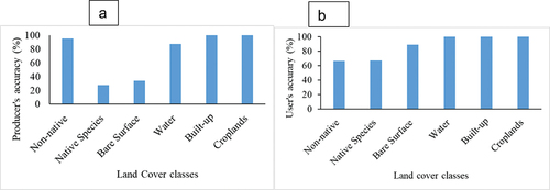
Figure 6. Output of the multispectral integration of Sentinel-1 and Sentinel-2 classification map at 10 m of geometrical resolution of the study area using object-based.
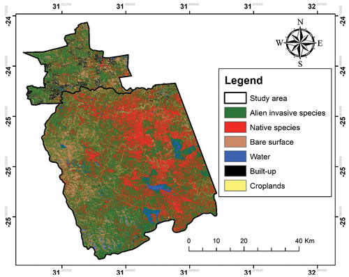
Table 2. The error metrics obtained from different land use classes, wherein the elements are the classification accuracies.
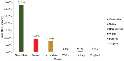
depicts a classification map derived from object-based RF classifications from Sentinel-1 and Sentinel-2 data for the non-native woody vegetation characterization map. The map depicts the six land cover classes, which are non-native species, native species, croplands, bare surface, water, and built-up. Non-native species dominated this study, while built-up areas were the least dominant. shows the area coverage per class in percentages based on the classification. The non-native species occupy 63.3% of the area covered in contrast to the 18.3% of the native species found within the study area. The third highest class is the bare surface which constitutes 14.9% of the study area, as shown in . shows that a large portion of the bare surface is found on the western side of the study compared to the native species located within the centre. The classes with the lowest percentages are cropland (0.2%); water (0.3%); and built-up area (0.7%).
Figure 7. The aerial coverage of the six classes in percentage from the output of Sentinel-2 and Sentinel-1 data.
4. Discussion
4.1. Integration for improving classification accuracy and satellite-derived selected variables
This study focused on the classification of non-native species vegetation (encroachers) on savannah rangelands using multi-sensors Sentinel-1 and Sentinel-2 for the specific dates that corresponded with the field days of data collection in the study area. By combining Sentinel 1 and 2 data, a 70% classification accuracy was obtained. Furthermore, a multi-temporal and multi-source image classification framework was based on the random forest classifier. As a result of the higher abundance of a feature subset, the optical indices and cross-polarized SAR still dominate the model performance. However, handling this with care is imperative. It is difficult to map savannah and rangelands due to varying vegetation densities, high background soil signals, and spectral similarities (Symeonakis et al., Citation2018; Tsalyuk et al., Citation2017; Zhang et al., Citation2019). For better image classification based on the results obtained, spectral bands that can be used are B8, B11 and B12 coupled with the vegetation indices NDMI, NDPI, and EVI2. These spectral bands were included to see which band could easily distinguish between the two target classes. The reason that the NDVI could not distinguish between native and non-native species based on the results in is that this index is a measure of healthy, green vegetation – it has been demonstrated that empirically-derived NDVI products are unstable, varying in response to soil colour, soil moisture, and saturation effects from vegetation density (Gan et al., Citation2022; Urban et al., Citation2021; Vizzari, Citation2022). As previously demonstrated, NDVI is extremely sensitive to background factors such as vegetation canopy brightness and shade, as well as soil background brightness (Adagbasa et al., Citation2022; Anchang et al., Citation2020; Ludwig et al., Citation2019; Venter et al., Citation2020). The SAVI index is similar to the NDVI index, but it excludes the effects of soil pixels (Naidoo et al., Citation2012). It employs a canopy background adjustment factor, which is determined by vegetation density and frequently necessitates prior knowledge of vegetation amounts (Brandt et al., Citation2017; Symeonakis et al., Citation2018). EVI2, on the other hand, uses the blue reflectance region to compensate for soil background signals and to reduce atmospheric influences such as aerosol scattering (Venter et al., Citation2020). For the accuracy comparison of vegetation indices, NDMI, NDPI, and EVI2 show higher separability and accuracies.
Due to the increased water content in the vegetation, the VH signal partially reflects the decrease in backscatter seen in VV backscatter, but this is less pronounced. Because non-native and native plants absorb moisture more quickly on bare surfaces, the presence of leaves in a vegetation structure plays an important role in the scattering mechanism. A water cloud may correspond to the presence of leaves in forests, where the vegetation is viewed as a volume containing homogeneities, i.e. randomly distributed water molecules. Previously conducted savannah mapping research supports the importance of VV backscatter in mapping non-native woody cover in this study (Vermeulen et al., Citation2021). It should be more effective at detecting woody vegetation in dry regions, such as Kruger National Park and its surroundings because co-polarized radar (HH and VV polarization) is more sensitive to non-leaf canopy components (such as branches and stems) than cross-polarized radar (HV and VH polarization).
4.2. Uncertainties and deficiencies from the integration of Sentinel-1 and Sentinel-2
It was found in this study that Sentinel satellite imagery (optical and C-band SAR) can be used for mapping complex savannah systems with a resolution of 10 m. Savannah rangeland shrubs canopies are frequently smaller than 10 X 10 metres, resulting in two major problems: the actual size of smaller tree crowns is overestimated when mapped as a single 10 X10 m pixel (Anchang et al., Citation2020; Naidoo et al., Citation2012; K. Wessels et al., Citation2019). Additionally, spectral similarities, similar ecological composition, and the fact that native vegetation is highly variable and difficult to identify with Sentinel imagery could have contributed to confusion between native and non-native species evident in the error metrics. In a previous study by Vizzari (Citation2022), the object-based approach in GEE produced positive results for Sentinel-2 (10-m spatial resolution) for land cover classification. This coincides with the approach taken in this study in mapping the non-native woody vegetation of semi-arid savannah rangeland. Moreover, results from Naidoo et al. (Citation2016) show that woody vegetation cover that was mapped in southern African savannahs using longer wavelength L-band data (ALOS PALSAR), is more sensitive to dense woody vegetation. It is also worth noting that Naidoo et al. (Citation2012) integrated hyperspectral and LiDAR to classify savannah tree species in the Kruger National Park and found that some of the shorter trees (especially Acacia gerrardii/Dichrostachys cinerea and Terminalia sericea) were incorrectly classified. This is because some Acacia species are considered native, while others, such as Acacia swazica and Acacia gerrandii, are considered non-native. According to Anchang et al. (Citation2020), models of canopy cover would be influenced by the relative dominance of phenological types (e.g. Acacia sp. with short leaf production durations). In this study using the Sentinel-based model, the problem was a lack of precise phenology metrics and radar backscatter metrics, which are less sensitive to seasonal leaf dynamics. In addition to its very variable canopy and crown form, height, and other structural dimensions, savannah rangeland vegetation also includes open grassland patches and dense woody thickets (in contrast to more homogeneous forest vegetation), therefore these structural vegetation parameters must be considered.
The spectral signatures show that a non-native species class leads to a higher mean reflectance value, as expected from knowledge based on the reflectance behaviour of vegetation, senescent vegetation, and soil (Anchang et al., Citation2020; Naidoo et al., Citation2016; Urban et al., Citation2021). This could be attributed to the spectral mixing effect of soil and senescent vegetation. The volumetric scattering mechanism in upper tree canopies may result in higher backscatter values for woody species (both native and non-native) than for other classes. The harvest cycles cause the greatest Sentinel-1 VH backscatter dynamics in cultivated areas. For Sahel and South Africa respectively, Zhang et al. (Citation2019) and Urban et al. (Citation2021) showed that radar data overestimate woody vegetation. Land cover mapping can be improved by combining SAR with optical data, as suggested by previous research (Laurin et al., Citation2013; Symeonakis et al., Citation2018; Zhang et al., Citation2019).
4.3. Recommendation based on the findings of this study
This study demonstrates how the integration of multi-sensors in an object-based approach is possible in GEE and can result in a significant improvement in all accuracy parameters and the final map’s moderate quality. On a free platform like GEE, it was possible to utilize advanced classification processes to fully exploit the informative content of Sentinel-1 and Sentinel-2 data. This study, which integrates issues related to the sample size of both classes, focuses on the accuracies of binary classification (native species and non-native species vegetation). As a result, overall accuracy may be unreliable in this case, whereas recall and precision are more valuable measures. The overall accuracy is vulnerable to a sample size imbalance between native and non-native classes. Therefore, effectively combining the radar information of Sentinel-1 with the spectral information of Sentinel-2 for savannah rangeland coverage assessment in arid and semi-arid regions is a challenging task for the future.
5. Conclusion
The objective of this study was to map fractional cover non-native woody vegetation in the Kruger National Park and surrounding communal areas using multisource Sentinel-1 and Sentinel-2 data coupled with GEE to estimate the fractional cover of non-native woody vegetation cover. By combining satellite images with high spatial and temporal resolution (including optical and SAR data), this study attempted to distinguish regionally between native and non-native woody vegetation. However, based on the results of this study, the overall woody cover was overestimated due to the influence of vegetation beneath the non-native and native canopy in semiarid savannah rangelands. Despite this uncertainty, the mapping result derived from Sentinel-2 imagery provided more precise information regarding non-native coverage. This is due to the fact that some acacia species are considered native, whereas others, including Acacia swazica and Acacia gerrandii, are considered non-native. According to Anchang et al. (Citation2020), canopy cover models would be affected by the relative dominance of phenological types (e.g. Acacia species with short leaf production durations). In addition, despite the limitations of this research, it did produce some positive results, such as the observation that optical sensors perform better in studies of vegetation in semi-arid savannah rangelands like Kruger National Park. Understanding the ever-changing causes of bush encroachment is essential for wildlife conservation and agriculture.
Acknowledgments
The authors would like to acknowledge NRF Black Academics Advancement Programme (BAAP) (grant number: 138170) for funding the research. The authors gratefully acknowledge assistance from the Scientific Services division of South African National Parks (SANParks) in the form of accommodation at the research camp at Skukuza and escorts by game guards during fieldwork.
Disclosure statement
No potential conflict of interest was reported by the author(s).
Additional information
Funding
References
- Adagbasa, E. G., Mukwada, G., & Veettil, B. K. (2022). Mapping vegetation species succession in a mountainous grassland ecosystem using Landsat, ASTER MI, and Sentinel-2 data. Public Library of Science One, 17(1), e0256672. https://doi.org/10.1371/journal.pone.0256672
- AHPU (Agincourt Health and Population Unit). (2008). Population fact sheet for 2008 community feedback: Belfast Village. Medical Research Council/University of the Witwatersrand Rural Public Health and Health Transitions Research Unit.
- Amalisana, B., & Hernina, R.(2017, December). Land cover analysis by using pixel-based and object-based image classification method in Bogor. In IOP Conference Series: Earth and Environmental Science (Vol. 98, No. 1, pp. 012005). IOP Publishing. https://iopscience.iop.org/article/10.1088/1755-1315/98/1/012005/meta
- Anchang, J. Y., Prihodko, L., Ji, W., Kumar, S. S., Ross, C. W., Yu, Q. & Hanan, N. P. (2020). Toward operational mapping of woody canopy cover in tropical savannas using Google Earth Engine. Frontiers in Environmental Science, 8, 4. https://doi.org/10.3389/fenvs.2020.00004
- Arntzen, J. (1998). Economic valuation of communal rangelands in Botswana: A case study. CREED Working Paper Series No. 17. https://www.iied.org/sites/default/files/pdfs/migrate/8096IIED.pdf?
- Asner, G. P., Elmore, A. J., Olander, L. P., Martin, R. E., & Harris, A. T. (2004). Grazing systems, ecosystem responses, and global change. Annual Review of Environment and Resources, 29(1), 261–299. https://doi.org/10.1146/annurev.energy.29.062403.102142
- Baumann, M., Levers, C., Macchi, L., Bluhm, H., Waske, B., Gasparri, N. I., & Kuemmerle, T. (2018). Mapping continuous fields of tree and shrub cover across the gran chaco using Landsat 8 and Sentinel-1 data. Remote Sensing of Environment, 216, 201–211. https://doi.org/10.1016/j.rse.2018.06.044
- Bonham‐Carter, G. F., Agterberg, F. P., & Wright, D. F. (1989). Integration of geological datasets for gold exploration in Nova Scotia. Digital Geologic and Geographic Information Systems, 10, 15–23.
- Borges, J., Higginbottom, T. P., Symeonakis, E., & Jones, M. (2020). Sentinel-1 and Sentinel-2 data for savannah land cover mapping: Optimising the combination of sensors and seasons. Remote Sensing, 12(23), 3862. https://doi.org/10.3390/rs12233862
- Brandt, M., Tappan, G., Diouf, A. A., Beye, G., Mbow, C., & Fensholt, R. (2017). Woody vegetation die off and regeneration in response to rainfall variability in the west African sahel. Remote Sensing, 9(1), 39. https://doi.org/10.3390/rs9010039
- Brantley, S. T., Zinnert, J. C., & Young, D. R. (2011). Application of hyperspectral vegetation indices to detect variations in high leaf area index temperate shrub thicket canopies. Remote Sensing of Environment, 115(2), 514–523. https://doi.org/10.1016/j.rse.2010.09.020
- Breiman, L. (2001). Random forests. Machine Learning, 45(1), 5–32. https://doi.org/10.1023/A:1010933404324
- Cao, X., Liu, Y., Cui, X., Chen, J., & Chen, X. (2019). Mechanisms, monitoring and modeling of shrub encroachment into grassland: A review. International Journal of Digital Earth, 12(6), 625–641. https://doi.org/10.1080/17538947.2018.1478004
- Cao, X., Liu, Y., Liu, Q., Cui, X., Chen, X., & Chen, J. (2018). Estimating the age and population structure of encroaching shrubs in arid/semiarid grasslands using high spatial resolution remote sensing imagery. Remote Sensing of Environment, 216, 572–585. https://doi.org/10.1016/j.rse.2018.07.025
- Cho, M. A., Debba, P., Mathieu, R., Naidoo, L., Van Aardt, J. A. N., & Asner, G. P.(2010). Improving discrimination of savanna tree species through a multiple-endmember spectral angle mapper approach: Canopy-level analysis. IEEE Transactions on Geoscience & Remote Sensing, 48(11), 4133–4142.
- Cho, M. A., Naidoo, L., Mathieu, R., & Asner, G. P. (2011). Mapping savanna tree species using Carnegie Airborne Observatory hyperspectral data resampled to WorldView-2 multispectral configuration. Proc. 34th International Symposium on Remote Sensing of Environment, Sydney, Australia (Vol. 15). www.isprs.org/proceedings/2011/isrse-34/211104015Final00313.pdf
- Cho, M. A., Skidmore, A. K., & Sobhan, I. (2009). Mapping beech (fagus sylvatica L.) forest structure with airborne hyperspectral imagery. International Journal of Applied Earth Observation and Geoinformation, 11(3), 201–211.
- Clerici, N., Valbuena Calderón, C. A., & Posada, J. M. (2017). Fusion of sentinel-1A and sentinel-2A data for land cover mapping: A case study in the lower Magdalena region, Colombia. Journal of Maps, 13(2), 718–726.
- Curtis, B., & Mannheimer, C. (2005). Tree Atlas of Namibia. National Botanical Research Institute, Ministry of Agriculture, Water and Forestry.
- Dube, K., & Nhamo, G. (2020). Vulnerability of nature-based tourism to climate variability and change: Case of Kariba resort town, zimbabwe. Journal of Outdoor Recreation and Tourism, 29, 100281. https://doi.org/10.1016/j.jort.2020.100281
- Dube, T., Pandit, S., Shoko, C., Ramoelo, A., Mazvimavi, D., & Dalu, T. (2019). Numerical assessments of leaf area index in tropical savanna rangelands, South Africa using Landsat 8 OLI derived metrics and in-situ measurements. Remote Sensing, 11(7), 829. https://doi.org/10.3390/rs11070829
- Eastment, C., Humphrey, G., Hoffman, M. T., Gillson, L., & Fidelis, A. (2022). The influence of contrasting fire management practice on bush encroachment: Lessons from Bwabwata National Park, Namibia. Journal of Vegetation Science, 33(2), e13123. https://doi.org/10.1111/jvs.13123
- Gan, L., Cao, X., Chen, X., He, Q., Cui, X., & Zhao, C. (2022). Mapping shrub coverage in Xilin Gol Grassland with multi-temporal sentinel-2 imagery. Remote Sensing, 14(14), 3266. https://doi.org/10.3390/rs14143266
- Gil, A., Lobo, A., Abadi, M., Silva, L., & Calado, H. (2013). Mapping invasive woody plants in azores protected areas by using very high-resolution multispectral imagery. European Journal of Remote Sensing, 46(1), 289–304.
- Gorelick, N., Hancher, M., Dixon, M., Ilyushchenko, S., Thau, D., & Moore, R. (2017). Google earth engine: Planetary-scale geospatial analysis for everyone. Remote Sensing of Environment, 202, 18–27. https://doi.org/10.1016/j.rse.2017.06.031
- He, Y., D’Odorico, P., & De Wekker, S. F. (2015). The role of vegetation–microclimate feedback in promoting shrub encroachment in the northern Chihuahuan desert. Global Change Biology, 21(6), 2141–2154. https://doi.org/10.1111/gcb.12856
- Higginbottom, T. P., Symeonakis, E., Meyer, H., & van der Linden, S. (2018). Mapping fractional woody cover in semi-arid savannahs using multi-seasonal composites from Landsat data. ISPRS Journal of Photogrammetry and Remote Sensing, 139, 88–102. https://doi.org/10.1016/j.isprsjprs.2018.02.010
- Huete, A. R. (1988). A soil-adjusted vegetation index (SAVI). Remote Sensing of Environment, 25(3), 295–309. https://doi.org/10.1016/0034-4257(88)90106-X
- Kennedy, K. A., & Addison, P. A. (1987). Some considerations for the use of visual estimates of plant cover in biomonitoring. The Journal of Ecology, 75(1), 151–157. https://doi.org/10.2307/2260541
- Komac, B., Kéfi, S., Nuche, P., Escós, J., & Alados, C. L. (2013). Modeling shrub encroachment in subalpine grasslands under different environmental and management scenarios. Journal of Environmental Management, 121, 160–169. doi: https://doi.org/10.1016/j.jenvman.2013.01.038
- Lantz, N. J., & Wang, J. (2013). Object-based classification of worldview-2 imagery for mapping invasive common reed, phragmites australis. Canadian Journal of Remote Sensing, 39(4), 328–340.
- Laurin, G. V., Liesenberg, V., Chen, Q., Guerriero, L., Del Frate, F., Bartolini, A.& Valentini, R. (2013). Optical and SAR sensor synergies for forest and land cover mapping in a tropical site in West Africa. International Journal of Applied Earth Observation and Geoinformation, 21, 7–16. https://doi.org/10.1016/j.jag.2012.08.002
- Li, W., Niu, Z., Gao, S., Huang, N., & Chen, H. (2014). Correlating the horizontal and vertical distribution of lidar point clouds with components of biomass in a Picea crassifolia forest. Forests, 5(8), 1910–1930. https://doi.org/10.3390/f5081910
- Ludwig, M., Morgenthal, T., Detsch, F., Higginbottom, T. P., Valdes, M. L., Nauß, T., & Meyer, H. (2019). Machine learning and multi-sensor based modelling of woody vegetation in the Molopo Area, South Africa. Remote Sensing of Environment, 222, 195–203. https://doi.org/10.1016/j.rse.2018.12.019
- Macander, M. J., Frost, G. V., Nelson, P. R., & Swingley, C. S. (2017). Regional quantitative cover mapping of tundra plant functional types in Arctic Alaska. Remote Sensing, 9(10), 1024. https://doi.org/10.3390/rs9101024
- Mishra, N. B., & Crews, K. A. (2014). Mapping vegetation morphology types in a dry savanna ecosystem: Integrating hierarchical object-based image analysis with random forest. International Journal of Remote Sensing, 35(3), 1175–1198. https://doi.org/10.1080/01431161.2013.876120
- Muchapondwa, E., & Stage, J. (2013). The economic impacts of tourism in Botswana, Namibia and South Africa: Is poverty subsiding? Natural Resources Forum, 37(2), 80–89. https://doi.org/10.1111/1477-8947.12007
- Municipal Demarcation Board. (2006). Bushbuckridge Local Municipality. Retrieved July 30, 2023, from www.demarcation.org.za
- Munyati, C., Shaker, P., & Phasha, M. G. (2011). Using remotely sensed imagery to monitor savanna rangeland deterioration through woody plant proliferation: A case study from communal and biodiversity conservation rangeland sites in Mokopane, South Africa. Environmental Monitoring and Assessment, 176, 293–311.
- Munyati, C., & Sinthumule, N. I. (2016). Change in woody cover at representative sites in the Kruger National Park, South Africa, based on historical imagery. Springer Plus, 5(1), 1–23. https://doi.org/10.1186/s40064-016-3036-1
- Muoz, A. B. J., Perez, M. P. R., Lois, M. T. A. E., Gonzalez-Cobos, C. L., Antnez, M. G., Aguilar, F. J. C., Llorente, B. P., & Miguez, A. M. (2009). P0189 prevalence rates of medication errors in medication process phases. European Journal of Internal Medicine, 20(1), S68–S69. https://doi.org/10.1016/S0953-6205(09)60209-0
- Mutanga, O., & Rugege, D. (2006). Integrating remote sensing and spatial statistics to model herbaceous biomass distribution in a tropical savanna. International Journal of Remote Sensing, 27(16), 3499–3514. https://doi.org/10.1080/01431160600639735
- Naidoo, L., Cho, M. A., Mathieu, R., & Asner, G. (2012). Classification of savanna tree species, in the greater Kruger National Park region, by integrating hyperspectral and LiDAR data in a random forest data mining environment. ISPRS Journal of Photogrammetry and Remote Sensing, 69, 167–179. https://doi.org/10.1016/j.isprsjprs.2012.03.005
- Naidoo, L., Mathieu, R., Main, R., Wessels, K., & Asner, G. P. (2016). L-band synthetic aperture radar imagery performs better than optical datasets at retrieving woody fractional cover in deciduous, dry savannahs. International Journal of Applied Earth Observation and Geoinformation, 52, 54–64. https://doi.org/10.1016/j.jag.2016.05.006
- Nasiri, V., Deljouei, A., Moradi, F., Sadeghi, S. M. M., & Borz, S. A. (2022). Land use and land cover mapping using Sentinel-2, Landsat-8 satellite images, and Google Earth Engine: A Comparison of two composition methods. Remote Sensing, 14(9), 1977. https://doi.org/10.3390/rs14091977
- Olariu, H. G., Malambo, L., Popescu, S. C., Virgil, C., & Wilcox, B. P. (2022). Woody plant encroachment: Evaluating methodologies for semiarid woody species classification from drone images. Remote Sensing, 14(7), 1665. https://doi.org/10.3390/rs14071665
- Oldeland, J., Dorigo, W., Wesuls, D., & Jürgens, N. (2010). Mapping bush encroaching species by seasonal differences in hyperspectral imagery. Remote Sensing, 2(6), 1416–1438. https://doi.org/10.3390/rs2061416
- Pfeffer, K., Pebesma, E. J., & Burrough, P. A. (2003). Mapping alpine vegetation using vegetation observations and topographic attributes. Landscape Ecology, 18(8), 759–776. https://doi.org/10.1023/B:LAND.0000014471.78787.d0
- Schmidt, M., & Witte, C. (2010). Monitoring aquatic weeds in a river system using SPOT 5 satellite imagery. Journal of Applied Remote Sensing, 4(1), 043528.
- Schulz, D., Yin, H., Tischbein, B., Verleysdonk, S., Adamou, R., & Kumar, N. (2021). Land use mapping using sentinel-1 and sentinel-2 time series in a heterogeneous landscape in Niger, Sahel. ISPRS Journal of Photogrammetry and Remote Sensing, 178, 97–111. https://doi.org/10.1016/j.isprsjprs.2021.06.005
- Shafeian, E., Fassnacht, F. E., & Latifi, H. (2021). Mapping fractional woody cover in an extensive semi-arid woodland area at different spatial grains with sentinel-2 and very high-resolution data. International Journal of Applied Earth Observation and Geoinformation, 105, 102621. https://doi.org/10.1016/j.jag.2021.102621
- Sibanda, M., Mutanga, O., & Rouget, M. (2016). Discriminating rangeland management practices using simulated hyspIRI, Landsat 8 OLI, Sentinel 2 MSI, and VENµs spectral data. IEEE Journal of Selected Topics in Applied Earth Observations and Remote Sensing, 9(9), 3957–3969. https://doi.org/10.1109/JSTARS.2016.2574360
- Stafford, W., Birch, C., Etter, H., Blanchard, R., Mudavanhu, S., Angelstam, P. & Marais, C. (2017). The economics of landscape restoration: Benefits of controlling bush encroachment and invasive plant species in South Africa and Namibia. Ecosystem Services, 27, 193–202. https://doi.org/10.1016/j.ecoser.2016.11.021
- Stevens, N., Erasmus, B. F. N., Archibald, S., & Bond, W. J. (2016). Woody encroachment over 70 years in South African savannahs: Overgrazing, global change or extinction aftershock? Philosophical Transactions of the Royal Society B: Biological Sciences, 371(1703), 20150437. https://doi.org/10.1098/rstb.2015.0437
- Symeonakis, E., Higginbottom, T. P., Petroulaki, K., & Rabe, A. (2018). Optimisation of savannah land cover characterisation with optical and SAR data. Remote Sensing, 10(4), 499. https://doi.org/10.3390/rs10040499
- Symeonakis, E., Korkofigkas, A., Vamvoukakis, G., Stamou, G., & Arnau-Rosalen, E. (2020). Deep learning monitoring of woody vegetation density in a South African Savannah region. International Archives of the Photogrammetry, Remote Sensing and Spatial Information Sciences-ISPRS Archives, 43, 1645–1649. https://doi.org/10.5194/isprs-archives-XLIII-B3-2020-1645-2020
- Symeonakis, E., Petroulaki, K., & Higginbottom, T. (2016). Landsat-based woody vegetation cover monitoring in southern African savannahs. International Archives of the Photogrammetry, Remote Sensing and Spatial Information Sciences, 41, 563–567. https://doi.org/10.5194/isprs-archives-XLI-B7-563-2016
- Tassi, A., Gigante, D., Modica, G., DiMartino, L., & Vizzari, M. (2021). Pixel-vs. Object-based Landsat 8 data classification in google earth engine using random forest: The case study of Maiella National Park. Remote Sensing, 13(12), 2299. https://doi.org/10.3390/rs13122299
- Tsalyuk, M., Kelly, M., & Getz, W. M. (2017). Improving the prediction of African savanna vegetation variables using time series of MODIS products. ISPRS Journal of Photogrammetry and Remote Sensing, 131, 77–91. https://doi.org/10.1016/j.isprsjprs.2017.07.012
- Urban, M., Schellenberg, K., Morgenthal, T., Dubois, C., Hirner, A., Gessner, U., Mogonong, B., Zhang, Z., Baade, J., Collett, A., & Schmullius, C. (2021). Using Sentinel-1 and Sentinel-2 time series for Slangbos mapping in the Free State Province, South Africa. Remote Sensing, 13(17), 3342. https://doi.org/10.3390/rs13173342
- Venter, Z. S., Cramer, M. D., & Hawkins, H. J. (2018). Drivers of woody plant encroachment over Africa. Nature Communications, 9(1), 2272. https://doi.org/10.1038/s41467-018-04616-8
- Venter, Z. S., Scott, S. L., Desmet, P. G., & Hoffman, M. T. (2020). Application of Landsat-derived vegetation trends over South Africa: Potential for monitoring land degradation and restoration. Ecological Indicators, 113, 106206. https://doi.org/10.1016/j.ecolind.2020.106206
- Vermeulen, L. M., Munch, Z., & Palmer, A. (2021). Fractional vegetation cover estimation in southern African rangelands using spectral mixture analysis and Google Earth Engine. Computers and Electronics in Agriculture, 182, 105980. https://doi.org/10.1016/j.compag.2020.105980
- Vizzari, M. (2022). PlanetScope, Sentinel-2, and Sentinel-1 data integration for object-based land cover classification in Google Earth Engine. Remote Sensing, 14(11), 2628. https://doi.org/10.3390/rs14112628
- Ward, D. (2005). Do we understand the causes of bush encroachment in African savannas? African Journal of Range and Forage Science, 22(2), 101–105. https://doi.org/10.2989/10220110509485867
- Wessels, K. J., Colgan, M. S., Erasmus, B. F. N., Asner, G. P., Twine, W. C., Mathieu, R., van Aardt, J. A. N., Fisher, J. T., & Smit, I. P. (2013). Unsustainable fuelwood extraction from South African savannas. Environmental Research Letters, 8(1), 014007. https://doi.org/10.1088/1748-9326/8/1/014007
- Wessels, K., Mathieu, R., Knox, N., Main, R., Naidoo, L., & Steenkamp, K. (2019). Mapping and monitoring fractional woody vegetation cover in the arid savannas of Namibia using LiDAR training data, machine learning, and ALOS PALSAR data. Remote Sensing, 11(22), 2633. https://doi.org/10.3390/rs11222633
- Xian, G., Homer, C., Rigge, M., Shi, H., & Meyer, D. (2015). Characterization of shrubland ecosystem components as continuous fields in the northwest United States. Remote Sensing of Environment, 168, 286–300. https://doi.org/10.1016/j.rse.2015.07.014
- Zerrouki, N., & Bouchaffra, D. (2014). Pixel-based or object-based: Which approach is more appropriate for remote sensing image classification? 2014 IEEE International Conference on Systems, Man, and Cybernetics (SMC) (pp. 864–869). IEEE. https://ieeexplore.ieee.org/abstract/document/6974020
- Zhang, W., Brandt, M., Wang, Q., Prishchepov, A. V., Tucker, C. J., Li, Y., Lyu, H., & Fensholt, R. (2019). From woody cover to woody canopies: How Sentinel-1 and Sentinel-2 data advance the mapping of woody plants in savannas. Remote Sensing of Environment, 234, 111465. https://doi.org/10.1016/j.rse.2019.111465
- Zhou, B., Okin, G. S., & Zhang, J. (2020). Leveraging google earth engine (GEE) and machine learning algorithms to incorporate in situ measurement from different times for rangelands monitoring. Remote Sensing of Environment, 236, 111521. https://doi.org/10.1016/j.rse.2019.111521