
 ?Mathematical formulae have been encoded as MathML and are displayed in this HTML version using MathJax in order to improve their display. Uncheck the box to turn MathJax off. This feature requires Javascript. Click on a formula to zoom.
Abstract
Jiangxi has superior natural environmental conditions, but tourism development is insufficient. This study analysed the distribution characteristics of natural tourism resources in Jiangxi Province, evaluated the potential of ecotourism, spatialized the coupling and coordination relationship between tourism resources and tourism potential and proposed the direction of tourism development and study travel planning. Results: (1) Natural tourist attractions in Jiangxi are relatively dense in the north and northeast, while relatively sparse in the south. (2) Natural tourism potential is generally high in the surrounding and low in the middle and high in the south and low in the north, and are distributed in a strip like manner. (3) Jiangxi is basically in a coordinated state, with the overall coupling index is relatively high, while the spatial differences in coordination index are significant, indicating that natural tourism resources and natural tourism potential have a strong mutual influence but their distribution characteristics do not match. (4) Future optimized development zone of natural tourism will be in the north and northeast, and the expanded development zone will be in the northwest and southeast. Both thematic and comprehensive study travel routes can be launched in regions with relatively concentrated natural tourist attractions. This article provides a research perspective on the interaction between tourism resource endowment and development practices, and the results can provide reference for relevant fields, natural tourism development, and study travel practices.
1. Introduction
Urbanization, characterized by urban expansion, is currently the main direction of global social development. At the same time, this process is accompanied by population and resource aggregation, land use/land cover changes (Wang X, Liu, Xiang, et al. 2022; Wang F et al. Citation2023) and also causes various environmental pollution (Shang et al. Citation2017; Wang X, Zhong, et al. Citation2022), ecological quality continues to decline, prompting people to pay more attention to ecological environment protection, residents’ health and achieve sustainable development (Geng, Zhang, et al. Citation2023; Liu R et al. Citation2023; Wang X, Liu, Zhang, et al. 2023). Strengthening contact with nature is beneficial to the health of urban residents. However, the current level of attention has not yet reached its rightful level, as the development of natural tourism resources is very insufficient. There are various natural and ecological tourism resources within China, which have enormous development potential. Conducting a survey of tourist attractions is an important means of understanding the current situation of regional tourism development. Tourism potential assessment is an important reference for guiding tourism development and optimizing the distribution of tourism resources.
The progress of society has made people pay more attention to the scientifization of education and the relationship between education and social development (Geng, Chen, et al. Citation2023). Not only technology is directly applied to education and teaching, but also emphasizes the comprehensive development of student quality (Xue and Li Citation2023). Traditional exam-oriented education can no longer meet the demand for talent in modern society, and more and more parents and educators are beginning to reflect on the essence of education. As an educational method that combines education with entertainment, study travel can enable students to learn knowledge and cultivate comprehensive qualities through practice, which is in line with the concept of modern education. In November 2016, the Ministry of Education and other 11 departments jointly issued a document entitled ‘Implementation Opinions on Promoting Research Trips for Primary and Middle School Students’, which clearly proposed to include study tour in the curriculum system of primary and secondary schools, and encouraged schools to organize students to participate in study travel. The promotion of policies has gradually made study travel a mainstream educational method, attracting more and more attention from schools and parents. However, study travel is different from regular trips and have clear requirements for education and health guidance at tourist destinations. Therefore, it is necessary to conduct tourism resource surveys and tourism potential assessments before carrying out tourism study travel.
Jiangxi is a province in southern China with beautiful natural environment in Jiangxi. few people are familiar with its tourist attractions, and the relatively closed hilly and mountainous terrain hinders tourists from experiencing natural tourism in depth, leading to an imbalance between existing development and resource potential. At the same time, the rapid popularity of natural ecotourism may result in the market and managers lacking sufficient experience to deal with potential problems. Therefore, evaluating the relationship between tourism resources and tourism potential is particularly important. However, relevant studies only analyse the distribution characteristics or tourism potential of tourist attractions, and there are few comparisons and evaluations of the coupling and coordination status between the two. As for study travel, there are still significant deficiencies in scenic spot research, route planning and management training. This study first analysed the distribution characteristics of natural tourist attractions and then used the weighted comprehensive evaluation method to evaluate the potential of ecotourism from 18 indicators of ecological environment and socio-economic aspects. Then, the coupling coordination degree model was used to analyse the coupling index, coordination index and coupling coordination scheduling between the distribution of existing natural tourist attractions and the potential of ecotourism, Finally, the tourism development index is used to evaluate the current state of lagging behind in tourism development and propose corresponding tourism development directions and study travel routes. We hope that relevant research can provide ideas for the tourism development and rural revitalization in Jiangxi Province (Geng, Liu, et al. Citation2023) and provide reference for the coordinated and sustainable development of regional economy.
2. Related research
2.1. Tourist attractions distribution and tourism potential evaluation
Survey of tourist attractions and assessment of regional tourism potential are prerequisites and foundations for tourism development. The survey of tourist attractions and the assessment of regional tourism potential are often paid attention to together. Cetin et al. (Citation2018) used SWOT (strengths, weaknesses, opportunities and threats) to evaluate the tourism potential and sustainability of Yesilyuva Natural Park and found that the natural beauty within the park is an important reason for tourists to frequently come here for tourism activities. At the same time, the support of GIS (geographic information system) digitization for scenic spots will help with landscape planning. Nofiarli (Citation2018) used SWOT analysis data to conclude that the natural attractions of Taitebatu Village can be developed using an ecotourism model. Duby et al. (Citation2022) used SWOT analysis to conclude that Semongkat Natural Tourism Park is worth developing, and the proposed strategy can achieve 76.11% feasibility. Priskin (Citation2001) used qualitative and quantitative techniques to determine the attractiveness, accessibility, presence of infrastructure and degree of environmental degradation of natural tourism resources in the Central Coast region of Western Australia. Data were collected using inventory methods to quantify the characteristics of the sites, resulting in 65 potential natural based tourism resource points. Irwandi et al. (Citation2023) combined descriptive and qualitative methods to evaluate the natural tourism potential of the BenerMeriah area, providing an important reference for tourism bureaus to implement optimization measures. Purwoko et al. (Citation2021) used observation, structured interview and survey methods to determine the attraction of Gunung Leuser National Park to tourists and used the Likert scale to quantify the attractiveness level of natural attractions. Sujaritchai and Artnarong (Citation2017) presented the tourism patterns of various tourist attractions in the form of qualitative and descriptive insights, evaluating the attractiveness of tourist attractions from the perspective of tourists. This perspective was also noticed by Kim et al. (Citation2019). They used social big data, such as Flickr geographical marker photos, to investigate the natural tourism of ASEAN heritage parks (AHP), which can effectively explain the spatial pattern of access and reveal the local spatial impact of distributed attributes. This geographically labelled photo dataset, combined with neural networks, can also be applied to personalized route recommendation (Mou et al. Citation2022). In addition, the distribution and potential of rural tourism and Sports tourism are also concerned (Trukhachev Citation2015; Zuo et al. Citation2021; Zhang et al. Citation2022). The existing research has abundant on-site investigation data, providing a solid foundation for scientific research, but such investigation costs are relatively high. With the help of basic geographic data, tourism potential assessment can be carried out on a larger scale, which is also a focus of this study.
There are significant differences in the suitability of tourism environments among Chinese cities (Li Y et al. Citation2022). Jiangxi Province, located in southern China, has superior natural conditions and the potential to develop natural and ecological tourism. Nie et al. (Citation2019) believed that the spatial pattern of Jiangxi’s forest eco-tourism development potential showed a relatively obvious gradient distribution characteristics, that is, from the east, south and west to the inland, which was distributed in turn, which was highly coincident with the geographical spatial distribution pattern of Jiangxi Province. Jiang (Citation2017) believes that strengthening the understanding of the importance of Hakka culture in ecotourism and cultivating and enriching ecological scenic spots with Hakka culture connotation is the key to improving the competitiveness of ecotourism market in Fujian Guangdong Jiangxi border area. Zhu J (Citation2020) assessed the changes in the impact of Poyang Lake tourism environment from 2008 to 2015. In view of the contradiction between rich natural ecological resources and economic and social development, Pan et al. (Citation2019) and Tan (Citation2020) used SWOT to analyse the development countermeasures of Poyang Lake Wetland Park ecotourism and Lushan National Nature Reserve forest health care base. Other scholars have explored the tourism resources and development factors in Jiangxi Province from the perspectives of scenic area development issues (Tian Citation2016), tourism industry development efficiency (Lv Citation2017), tourists’ willingness to revisit (Cheng et al. Citation2020) and tourism route network spatial structure (Xiao et al. Citation2020). These studies provide rich research materials for evaluating the potential of natural and ecotourism. However, existing research lacks analysis of the relationship between existing natural attractions and tourism potential from a spatial pattern perspective, which will result in a lack of reference materials for future tourism planning, ecological environment protection.
2.2. Research cases and implications of study travel
Study travel is an educational tourism activity that focuses on primary and secondary school students, uses collective travel as a carrier, aims to improve student quality and relies on social resources such as tourism attractions to provide experiential education and research-based learning. The key difference between study travel and other tourism products is that study travel focuses on learning knowledge while travelling. Study travel have some purposes, distinct from incidental or even unintentional outcome leisure travel (Mitchell Citation1998). The researchers from European and American countries have earlier noticed the association between education and tourism. And it’s not just about exploring basic education students. Research on backpackers has found that travel can be useful in developing generic skills such as problem solving, adaptability, social and cultural awareness, management of resources and self-awareness (Pearce and Foster Citation2007). Work on educational travel and study abroad experiences has shown that student travel can promote intellectual and personal growth, cross-cultural awareness, foreign language acquisition and professional development and recognize that international travel can also encourage reflective characteristics such as self-awareness, global citizenship and identity (Dolby Citation2004; Lewin Citation2010). However, these studies do not place learning within the framework of tourism, and the learning outcomes are only by-products of the tourism process. Learning within the travel context transcends the traditional school-based construct of knowledge transfer, and learning has always been a much neglected social science perspective in current tourism research (Falk et al. Citation2012). Outdoor education is a powerful supplement to study travel and can be considered one of the early forms of study travel. A survey of 15–16 years old adolescents in Lahti, Finland showed that the natural environment contributes to mental health, particularly by increasing calmness, improving emotions or positive emotions, revealing the importance of nature in adolescent leisure time experiences (Puhakka and Hakoköngäs Citation2023). Outdoor education also helps children’s stress regulation, brain development and brain function (Dettweiler et al. Citation2023).
Research on study travel in China started relatively late, especially in international studies. The study travel market, which is still in its early stages, needs to be optimized. Inspired by a survey based on Leshan City in Sichuan Province in China, there are three suggestions: develop characteristic research bases based on local conditions and do a good job in the construction of research bases strengthen the training of teachers and further promote the integration of moral and aesthetic education and strengthen the implementation system of supervision and responsibility to escort the research travel activities (Xu Citation2019). There are four suggestions from a survey in Zhaoqing (southern China): add channels for study travel information to lead the correct concept of study trave, strengthen the monitoring of the qualifications of practitioners and strengthen the training of relevant personnel, implement a safe and secure mechanism and do a good job of evaluation standards and feedback mechanism (Wen et al. Citation2020). A survey conducted in Handan City (northern China) from the perspectives of teachers and students shows that study travel activity courses play an important role in improving students’ comprehensive quality and cultivating their socialist core values, and it is also an inevitable way to perfect the curriculum system and promote the comprehensive development of students; In ddition, study travel brings several advantages, such as promoting the sustainable development of the tourism economy and also promotes the development of industries related to study travel (Wang J and Abukhalifeh Citation2021). Based on SWOT analysis, there are the following development suggestions for specific tourism products—intangible cultural heritage: multi-channel to increase the publicity of non-foreign heritage study travel, strengthen the integration of research and tourism and the construction of Shaoxing research and study course system, clear target positioning and accelerate the construction of base camps and strengthen the integration of resources and focus on improving the quality of study travel (Lin and Zhang Citation2023). These studies indicate that research on study travel in China are still extremely weak, mainly focusing on market status surveys and proposing policy recommendations. There is a lack of conducting tourism resource assessments from a research perspective and proposing different study travel routes.
3. Materials and methods
3.1. Study area
Jiangxi Province, located in the southeast of China (), is a transitional zone between East China, Central China and South China. It is known as the ‘World Tungsten Capital’, ‘Rare Earth Kingdom’, ‘China Copper Capital’, ‘Home of Nonferrous Metals’, ‘China Pharmaceutical Capital’, ‘World Umbilical Township’, etc. The territory has a typical subtropical monsoon climate, with an average annual temperature of about 16.3–19.5 °C, annual precipitation of 1341–1943 mm, rich water and heat resources and frequent meteorological disasters such as rainstorm (Wang X, Liu, Lin, et al. 2022; Liu G, Xiang, Wan, Zhou, et al. 2023; Wang X, Liu, Xiang, et al. Citation2023). Warm loving plants such as Camellia oleifera are all over Jiangxi, where mainly vegetation in this area is evergreen broad-leaved forest, with typical subtropical forest plant communities (Liu G, Xiang, Wan, Lv, et al. 2023). In 2018, the forest coverage of Jiangxi Province reached 63.1%, the forest stock exceeded 500 million m3, the total water resources were 1149.09 billion m3, and there were more than 70 provincial-level forest cities in the province, which shows that Jiangxi Province has an excellent natural geographical environment. In the southeast of China, the level of economic development in Jiangxi Province is average. Nighttime lighting shows that there are fewer concentrated and contiguous large cities in Jiangxi Province compared to surrounding provinces (). Nearby, there are Yangtze River Delta Urban Agglomerations (YRDUA), Yangtze River Middle Reach Urban Agglomerations (YRMRUA) and Guangdong-Hong Kong-Macao Greater Bay Area (GHMGBA) (). The development of natural tourism in Jiangxi can attract residents from surrounding cities to come here for tourism.
Figure 1. Study area. (a) Location of Jiangxi Province in China, where ISM, EASM and EAWM represent Indian Summer Monsoon, East Asian Summer Monsoon and East Asian Winter Monsoon, respectively (Wang X et al. Citation2021; Wang X, Liu, Xiang, et al. Citation2023); (b) night lights in Jiangxi Province and its surrounding areas; and (c) topographic distribution of Jiangxi and its surrounding areas, where YRDUA, YRMRUA and GHMGBA represent Yangtze River Delta Urban Agglomerations, Yangtze River Middle Reach Urban Agglomerations and Guangdong-Hong Kong-Macao Greater Bay Area, respectively. Nanchang (NC) and JJ (Jiujiang) are located in northern Jiangxi; YC (Yichun), XY (Xinyu) and PX (Pingxiang) are located in western Jiangxi; JDZ (Jingdezhen), SR (Shangrao) and YT (Yingtan) are located in northeast Jiangxi; JA (ji’an) and FZ (Fuzhou) are located in central Jiangxi; and GZ (Ganzhou) is located in southern Jiangxi.
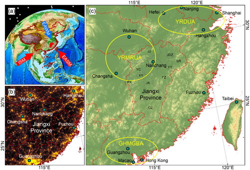
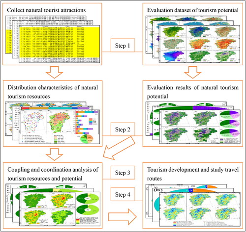
Figure 2. Research framework.
3.2. Research framework and data
This study has the following four steps (): (1) Collecting the names of natural tourist attractions and querying their coordinates and establishing a database for evaluating the potential of natural tourism; (2) analyse the distribution characteristics of natural tourist attractions and conducting evaluation of natural tourism potential; (3) analysis of the coupling and coordination between natural tourist attractions and tourism potential; (4) propose the direction of tourism development and study travel routes.
A total of 146 scenic spots data of natural tourist attractions comes from the list published on the official website of each tourism bureau or committee (). Combining with the Internet search results, five types of scenic spots in Jiangxi Province, including national scenic area, national forest park, national wetland park, national nature reserve and water conservancy scenic area, are identified as natural tourist attractions and then coordinate pickups on the Open platform of Baidu Maps (http://api.map.baidu.com/lbsapi/getpoint/). Obtain the coordinates of each scenic spot and organize the natural tourist attractions with overlapping titles.
Table 1. Data source.
Elevation data sourced from STRM (http://srtm.csi.cgiar.org/) () and calculate other terrain related factors. Climate data sourced from China Meteorological Data Network (http://data.cma.cn) (1980–2015) and WorldClim (https://www.worldclim.org/) (1970–2000). Normalized difference vegetation index (NDVI) data (2018), land use data (2018), population density (2015), GDP density (2015) and ecosystem service value (2015) are from the Data Center of Resources and Environmental Sciences of the Chinese Academy of Sciences (http://www.resdc.cn/). The habitat quality index is calculated using land use and land cover (LULC) data (MEPPRC Citation2015). The ecological disturbance index is calculated using land use data assignment (Feng et al. Citation2017; Wang X, Liu, Lin, et al. 2022). Traffic density is obtained by calculating linear density using the road (2019) of Open Street Map (https://www.openstreetmap.org/). The night light data (2017) is sourced from the Geographic Resources and Ecological Professional Knowledge Service System of the China Engineering Science and Technology Knowledge Center (http://geo.ckcest.cn/). The distance from cities, roads and water bodies is obtained by calculating the path distance using GIS. The unified coordinate system for all data is GCS_WGS_1984 and Asia_Lambert_Conformal_Conic. The map passes downloaded through the Resource and Environmental Science Data Center of the Chinese Academy of Sciences (http://www.resdc.cn/) and Jiangxi Provincial Department of Natural Resources Jiangxi Standard Map Service (http://bnr.jiangxi.gov.cn/).
3.3. Natural tourism potential evaluation model
The natural tourism potential index is a weighted linear synthesis of multiple factors and indicators. Compared with other methods, the weighted comprehensive evaluation method can simultaneously consider evaluation indicators of different types and importance, avoiding the influence of a single factor on the evaluation results. It has important application value for decision-making and evaluation of multiple indicators in natural tourism potential evaluation. The calculation formula for the weighted comprehensive evaluation method is as follows:
(1)
(1)
In the formula: E is the natural tourism potential index; n is the number of indicators participating in the evaluation; Wi is the weight of the participating evaluation indicators; Fi is the assigned data obtained from indicator grading or standardization.
This study analysed the natural tourism potential of Jiangxi Province from the perspectives of ecological environmental and socio-economic conditions, and based on this, 18 indicators were determined (). The weights were evaluated through AHP and determined by expert scoring. The ecological environment conditions are the foundation of resources, and their advantages and disadvantages are related to the richness of natural tourism resources, determining the potential of natural tourism. Select 9 indicators to evaluate ecological environmental factors, including elevation, topographic relief, slope, aspect, annual average temperature, highest temperature from June to September, annual precipitation, NDVI, and habitat quality index. Socio economic conditions are often limiting factors and to some extent, factors that interfere with the ecological environment. Select 9 indicators to evaluate socio-economic factors, including population density, GDP density, road density, night light, distance to cities, distance to roads, distance to water bodies, ecosystem service value, and ecological human disturbance index.
Table 2. Evaluation indicators and weights of natural tourism potential in Jiangxi Province.
In order to eliminate unit and dimensional differences between different data and consider the spatial distribution characteristics of raster data, GIS reclassification can be used instead of normalization and standardization. Meanwhile, the indicators in this study are not simply positive or negative effects, and the reclassification function can adjust the level by setting high and low categories after discontinuities. The elevation, topographic relief, slope and aspect are interval based on empirical values, while other indicators are interval based on the natural breakpoint method. Then, the low to high potential grading is adjusted according to the actual research situation.
3.4. Coupling coordination degree model
There is mutual influence between existing tourism resources and tourism potential, and coupling coordination degree model can reflect this relationship. The coupling degree reflects the strength of the interaction between natural resources and natural tourism potential, and the coordination degree reflects whether the mutual influence between the two develops towards mutual promotion or destruction. The calculation method is as follows (Li Q et al. Citation2021; Zhu S et al. Citation2022; Yan et al. Citation2023):
(2)
(2)
(3)
(3)
(4)
(4)
(5)
(5)
In the formula: D is the coupling coordination degree of natural tourism resources and natural tourism potential, with a value range of [0, 1]. When D = 1, it indicates that the two have reached the best state of benign interaction, existing development areas are concentrated in high potential areas; while when D = 0, it is the opposite, high potential areas are not developed. C is the coupling degree between natural tourism resources and natural tourism potential, with a value range of [0, 1]. When C = 1, it indicates a strong interaction and influence between the two; while when C = 0, it is the opposite and the two are in an unrelated state. T is the coordination index between natural tourism resources and natural tourism potential, with a value range of [0, 1]. When T = 1, it indicates that the two are in a benign coupling optimal state, and their distribution is almost consistent; When T = 0, it is the opposite, and the two systems are mutually constrained. R and E is the comprehensive evaluation index of natural tourism resources and natural tourism potential, respectively. In this article, it is the normalized path distance index of natural tourism attractions and the normalized value of the comprehensive evaluation results of natural tourism potential. α and β are all undetermined coefficients and set α + β = 1. Due to the need for tourism resource development to be in line with tourism potential, both are equally important. Therefore, this article α and β take 0.5 for all. K is the tourism development index, with a value range of [−1, 1], indicating that the level of tourism development lags behind to a leading state.
The degree of coupling coordination can be divided into multiple levels (Li Q et al. Citation2021; Yan et al. Citation2023). Based on the measurement results, this study is divided into five categories: 0 ≤ D < 0.2 is severe imbalance, 0.2 ≤ D < 0.4 is moderate imbalance, 0.4 ≤ D < 0.6 is basic coordination, 0.6 ≤ D < 0.8 is moderate coordination, and 0.8 ≤ D < 1 is high coordination. At the same time, this article introduces the tourism development index K, which is divided into five categories: −1 ≤ K< −0.6 is severe hysteresis, −0.6 ≤ K< −0.2 is moderate hysteresis, −0.2 ≤ K < 0.2 is basic synchronization, 0.2 ≤ K < 0.6 is moderate ahead, 0.6 ≤ K ≤ 1 is severe ahead, hysteresis represents exploitable, and ahead represents excessive development or the need for optimized development.
4. Results
4.1. Distribution characteristics of natural tourism resources
4.1.1. Spatial distribution of natural tourism resources
The 146 natural tourist attractions in Jiangxi Province are distributed in various cities, but there are differences. They are densely distributed in the northern and northeastern, while the density is relatively low in the southern (). Among them, Ganzhou (35), Shangrao (27), Jiujiang (21) and Ji’an (18) have a large number, while Yingtan has a high density (1.38/103 km2). The point density of the three cities in central and southern Jiangxi (Fuzhou, Ji’an and Ganzhou) and Yichun are relatively low, with only 0.47–0.86 points/103 km2, while other cities have 0.93 points/103 km2 or more. The distribution of different types of scenic spots also varies. National scenic areas are most distributed in Ganzhou and Shangrao, national forest parks are most distributed in Ganzhou, Shangrao and Jiujiang, national wetland parks and national nature reserves are most distributed in Ganzhou, and water conservancy scenic areas are most distributed in Shangrao, Ganzhou and Jiujiang ().
Figure 3. Spatial distribution of natural tourism resources in Jiangxi Province. (a) Distribution of different types of natural tourist attractions in cities; (b) topography and distribution of natural tourist attractions; (c) and (d) statistics of natural tourist attractions in different cities and elevations.
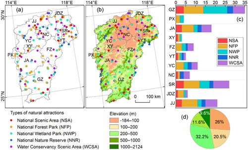
The natural tourist attractions distributed on the terrain of Jiangxi Province show that they are mainly distributed at medium to low altitudes (). The number of natural tourist attractions in plain areas below 100 m (38) and 100–200 m (30) accounts for 46.5%, and including in hilly areas 200–500 (47) accounts for 78.7%. National scenic area and water conservancy scenic area are distributed at both high and low altitudes, national forest parks and national nature reserves are mainly distributed at medium to high altitudes, and national wetland parks are mainly distributed at medium to low altitudes. Overall, natural tourist attractions are distributed in low mountain and hilly areas surrounded by low altitudes, as well as in areas such as the remaining veins and foothills of some mountain ranges, while relatively less distributed in the tall mountain ranges heart. The northern is relatively concentrated, while the southern is relatively scattered, corresponding to the terrain of many plains in the north and many hills and mountains in the south. It may also be related to the distribution and convenience of human production and life under the influence of natural environment.
4.1.2. Spatial pattern of natural tourism resources
The spatial density of natural tourist attractions shows that natural tourist attractions are relatively concentrated in the north and northeast, with less distribution in most areas of the central and eastern (). Among them, the eastern part of Jiujiang, the northwestern part of Nanchang, and the eastern part of Shangrao are relatively concentrated; Next are the eastern part of Pingxiang, the western part of Ganzhou, and Yingtan; From the southern part of Fuzhou to the eastern part of Ji’an, and from the southern and eastern parts of Ganzhou, there is no aggregation and scattered distribution; There is almost no distribution from the west of Poyang Lake to the north of Fuzhou, the northwest of Jiujiang, the central part of Yichun and the central north of Ganzhou.
Figure 4. Spatial pattern of natural tourism resources in Jiangxi Province. (a) Normalized kernel density of natural tourist attractions distribution; (b) national scenic area; (c) national forest park; (d) national wetland park; (e) national nature reserve; (f) water conservancy scenic area; and (g) Normalized inverse path distance of natural tourist attractions distribution.
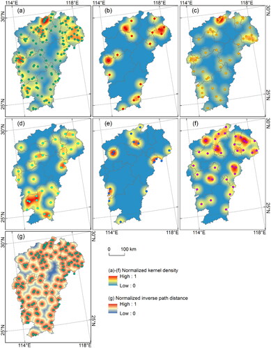
National scenic area and national forest parks are relatively dense in the north and northeast, followed by the west, and scattered in the south (). On the contrary, the national wetland park is relatively dense in the south and sparse in the north (). The national nature reserves are mainly relatively dense in the surrounding areas and are generally sparse (). The water conservancy scenic areas are relatively dense in the north and northeast, followed by the central part, and sparse in the south ().
The path distance index also shows that the northern and northeastern regions are the most dense, followed by the western and southern regions, and the central region is relatively sparse (). The high path distance index in the north and northeast indicates that the distances between different scenic spots are relatively close. The lowest path distance index in the central and northern regions is the lowest, as the distribution of scenic spots is minimal dense and requires a longer distance to reach surrounding scenic spots.
4.2. Evaluation dataset of natural tourism potential
4.2.1. Ecological environmental factors
The nine indicators of ecological environmental factor can be roughly divided into three categories: terrain and geomorphology (elevation, topographic relief, slope, aspect), climate (annual average temperature, highest temperature from June to September, annual precipitation) and vegetation and habitat quality index (NDVI and habitat quality index) (). There is no significant consistency between the distribution of natural tourist attractions and ecological environmental factors, indicating differences in the impact of different indicators.
Figure 5. Ecological environmental factors of natural tourism potential in Jiangxi Province. (a) Elevation; (b) topographic relief; (c) slope; (d) slope aspect; (e) annual average temperature; (f) highest temperature from June to September; (g) annual precipitation; (h) normalized difference vegetation index; and (i) habitat quality index.
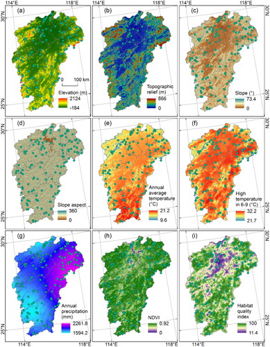
The distribution characteristics of elevation, topographic relief and slope are relatively consistent, with lower elevations, gentle topographic relief and smaller slopes in the north. There are relatively more natural tourist attractions in here, but the distribution characteristics of slope direction are not obvious ().
The average annual temperature is higher in the south and lower in the north, which is consistent with the basic distribution pattern of temperature (). The spatial characteristics of high temperatures from June to September are closely related to altitude distribution, with overall higher temperatures, and a few higher altitude areas have lower temperatures (). The distribution of precipitation is more in the northeast and less in the northwest and southwest, which is related to the distance from the ocean and terrain obstruction (). Natural tourist attractions are generally distributed in areas with cooler temperatures.
The overall NDVI is relatively high, indicating good vegetation coverage in Jiangxi Province (). The habitat quality index is also high, indicating that the ecological environment quality in the study area is also good and is relatively low only along the rivers and lakes (). Natural tourist attractions are mainly distributed in areas with good vegetation coverage and high habitat quality.
4.2.2. Socio economic factors
The nine indicators of socio-economic factor can be roughly divided into three categories: socio-economic productivity indicators (population, GDP, road density, nighttime light index), distance indicators (distance from cities, roads and water) and ecological value and disturbance (ecosystem service value and human disturbance index) (). There is no significant consistency between the distribution of natural tourist attractions and socio-economic factors, and the impact of some indicators may be more significant.
Figure 6. Socio economic factors of natural tourism potential in Jiangxi Province. (a) Population density; (b) GDP density; (c) road density (d) night light; (e) distance to cities; (f) distance to roads; (g) distance to water bodies; (h) ecosystem service value; and (i) ecological human disturbance index.
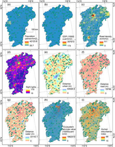
The spatial heterogeneity of population and GDP data is relatively small, indicating that there is no significant difference in the distribution of population and GDP in larger regions. This may be due to the fact that the data is based on counties as statistical units (). In addition, the road density is relatively high in Nanchang, Ganzhou, Shangrao, Beijing-Kowloon railway, Shanghai-Kunming High Speed Railway and low in other areas (). This distribution feature is particularly evident in the nighttime light index, with a cluster like distribution in Nanchang and Ganzhou and a combination of traffic distribution along the line and strip (). The distribution of natural tourist attractions is not related to population and GDP distribution, while road density and nighttime light index indicate that natural tourist attractions are distributed in areas with relatively low human activity.
The distance from the cities shows that the distance between cities in the northern and northeastern regions is relatively close, indicating a larger number of cities, while the distribution of cities in the central and southern regions is relatively sparse (). The distance from the road shows similar characteristics, with the roads in the north and northeast being closer, indicating dense roads, while the roads in the central and southern regions and marginal areas are sparse (). The distance from the water body also reflects the terrain distribution to a certain extent. In flat plains or river valleys, the distance from the water body is relatively close (). Overall, natural tourist attractions are generally distributed in places with a certain distance from cities, roads and water bodies.
The value of ecosystem services is higher in Poyang Lake in the north and lower in other regions (). The distribution of natural tourist attractions has no obvious characteristics. The human disturbance index is also higher in the northern plain and central valley areas, while lower in the surrounding areas, which is related to the distribution of land use and land cover (). Natural tourist attractions are generally distributed in areas with moderate disturbance places.
4.3. Evaluation results of natural tourism potential
4.3.1. Evaluation results of natural tourism potential at grid scale
The evaluation results of natural environmental factors () show that the overall potential for natural tourism is high in the surrounding area, low in the middle, high in the south and low in the north, with little difference in the proportion of various potential areas (18% −29.87%) (). Poyang Lake, coastal plain and flat zone along the main riverway of Ganjiang River have low potential and are distributed in a concentrated area. The hilly and mountainous areas in the northwest, west, south, east and northeast regions have high potential and are distributed in strips and blocks. The results are similar to the distribution of terrain and geomorphic conditions. Except for the high proportion of such indicators (4/9), other factors such as temperature, precipitation and NDVI are all affected by the basic geomorphic pattern. The evaluation results reflect the convenience degree of human development under natural environmental conditions. Low potential of natural tourism represents ease of development, while high potential indicates difficulty in development and good ecological environment preservation.
Figure 7. Evaluation of natural tourism potential in Jiangxi Province. (a) Evaluation of natural environmental factors; (b) evaluation of social economic factors; (c) comprehensive evaluation combining natural environment and socio-economic factors; (d) county division of comprehensive evaluation; and (e–g) the area proportion of different levels of natural tourism potential based on natural environment, social economic and comprehensive evaluation, respectively.
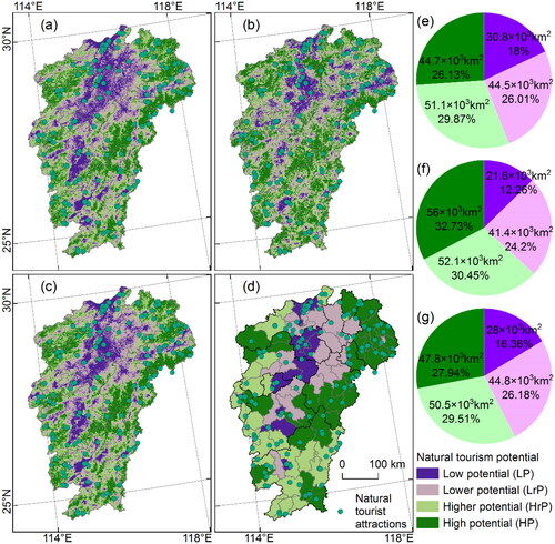
The evaluation results of socio-economic factors () show that the overall potential of natural tourism is higher and high, with an increasing proportion of areas from low potential to high potential (12.62% −32.73%) (). The potential along the north-south Beijing-Kowloon railway and the east-west Shanghai Kunming High speed Railway is low, showing a cluster belt combination. Its peripheral transition area is also the rural-urban fringe, which has a high potential and is distributed in strips and blocks. The results are relatively corresponding to the exponential distribution of traffic density and night light, while the correlation with the distribution of population density and GDP density is relatively weak. This may be because although population and GDP are spatial data, they are still based on administrative regions as the basic statistical unit, which is difficult to reflect the distribution under the grid scale. At the same time, the spatial differentiation of population and GDP is extremely serious, resulting in no obvious difference between categories except extreme values, and more high potential areas, also weakens its contribution to the evaluation of socio-economic factors. The evaluation results reflect the current situation of human activities in the development and utilization of the environment. A higher level of development and utilization may result in lower potential for natural tourism, while a lower level of development and utilization reflects a better maintenance of the natural environment and a higher potential for natural tourism.
The comprehensive evaluation results () show that the overall potential of natural tourism is also high in the surrounding area, low in the middle, high in the south and low in the north. Also, there are small difference of various potential areas proportion (16.36% −29.51%), with the low potential area being the smallest (28 × 103km2), while the high potential area is the largest (50.5 × 10³km2) (). The potential along the north-south Beijing-Kowloon railway and the east-west Shanghai Kunming High speed Railway is low, with the characteristics of cluster belt and contiguous distribution. From the regional perspective, it is along the rivers and lakes in the east of Jiujiang City, Nanchang City, traffic line of Pingxiang-Yichun-Xinyu-Nanchang-Yingtan-Shangrao, along the Ganjiang River of Nanchang-Yichun -East Ji’an-Ganzhou. The hilly and mountainous areas in the northwest, west, south, east and northeast regions have high potential and are distributed in a strip block shape. Specifically, there are central and western Jiujiang, central and western Yichun, central and western Ji’an, southeast Ganzhou, central and southern Fuzhou, southern and northern Shangrao and Jingdezhen. The comprehensive evaluation of natural tourism potential is the result of the comprehensive effect of natural and social conditions. From a distribution perspective, the natural environment still plays a dominant role, not only because of its high weight, but also because the distribution of socio-economic conditions is constrained by the foundation of the natural environment. Although many socio-economic factors may be limiting factors, based on the analysis of 9 indicator data, the socio-economic conditions have not yet broken through the existing natural environment constraints, indicating that the ecological environment in Jiangxi Province is maintained well. Therefore, when evaluating the comprehensive potential of natural tourism across the province, the proportion of regions with higher or high potential (57.45%) is relatively large.
4.3.2. Evaluation results of natural tourism potential at the city and county scales
The evaluation of the natural tourism potential of 11 cities in Jiangxi shows that the difference in area proportion among different levels is relatively small in Jiujiang, Ji’an and Ganzhou, while the difference in area proportion in Jingdezhen, Shangrao, Nanchang and Xinyu is close to or more than four times between the maximum and minimum (). Among various cities, Ganzhou (52.9%), Pingxiang (59.6%), Fuzhou (63.3%), Yingtan (57.9%), Shangrao (64.1%) and Jingdezhen (63.8%) have a higher and high potential area proportion exceeding 50%. The lower potential is widely distributed in Jiujiang (31.6%), Xinyu (45.5%), Yingtan (31.6%), Yichun (38.7%) and Nanchang (49.2%). The areas proportion of low potential in Jiujiang (24.1%), Ji’an (21.5%), Xinyu (23.7%) and Nanchang (24.5%) is also not small.
Figure 8. The proportion of different levels of natural tourism potential evaluation in various cities of Jiangxi Province. (a) Area proportion and (b) county proportion.
The potential category with the largest area proportion in the county is set as the category of the county, and the proportion of counties and districts with different potential levels in each city varies significantly ( and ). Ganzhou, Pingxiang, Xinyu, Fuzhou, Shangrao, and Nanchang have a potential level exceeding 50%, especially low potential in Nanchang (88.9%). The evaluation results at the city and county scales also reflect the distribution status of low potential in the central and northern regions and high potential in the surrounding areas.
4.4. Coupling and coordination analysis of tourism resources and potential
4.4.1. Characteristics of coupling coordination degree at grid scale
The coupling index shows that the overall coupling degree between natural tourism resources and natural tourism potential in Jiangxi Province is relatively high (), and the two show strong mutual influence. Only the northern of Jiujiang, the western of Nanchang, the northern of Fuzhou, and the central of Ganzhou are relatively low, shows relatively weak of the mutual influence. The coordination index is unevenly distributed between high and low levels (), indicating that areas with benign coupling and mutual constraints between natural tourism resources and natural tourism potential are both distributed. Among them, the Poyang Lake Plain (Nanchang, western Shangrao and northeastern Fuzhou) with relatively flat terrain in the north central part, the main stream of the Ganjiang River valley (central Ganzhou, central Ji’an) and the mountainous and hilly areas in the central and western regions (central Yichun) are mostly in a bad state of mutual restriction, or the developed areas are poorly consistent with the high potential. However, small regions such as the northeast (central and eastern Shangrao, Jingdezhen), the west (western Ji’an, Pingxiang), and the north (central and western Jiujiang) are highly coordinated, and the distribution of natural tourism resources and potential is highly correlated.
Figure 9. Coupling and coordination of natural tourism potential in Jiangxi Province. (a) Coupling index; (b) coordination index; (c) coupling and coordination index; (d) coupling and coordination index at county scale; and (e–f) area and county proportion.
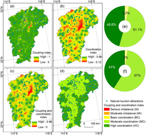
The coupling coordination results indicate that the natural tourism resources and potential in Jiangxi Province are basically in a coordinated state, with a relatively orderly and good development trend, but there are also spatial differences (). The areas with low index are mainly in the Poyang Lake Plain in north central Jiangxi (Nanchang, western Shangrao and northeastern Fuzhou), mountainous and hilly areas in central and western Jiangxi (central Yichun and western Jiujiang) and the main river valley of Ganjiang River (central Ganzhou and central Ji’an), but they are basically coordinated. These regions either have limited tourism resources or low natural tourism potential. The high index areas are the northeast of Jiangxi (central and eastern Shangrao, Jingdezhen), the north (central and western Jiujiang), the west (northwest of Ji’an, Pingxiang) and the western and eastern of Ganzhou. They are basically highly coordinated, with high natural tourism potential and relatively abundant tourism resources. The proportion of areas in the five categories from severe imbalance to high coordination is 0%, 0.1%, 3.24%, 51.07% and 45.59%, respectively (), and the proportion of counties and districts is 0%, 0%, 2%, 57% and 41%, respectively (, indicating that moderate coordination is dominant.
4.4.2. Characteristics of coupling coordination degree at the city and county scales
The area proportion of the coupling and coordination between natural tourism resources and tourism potential in 11 cities in Jiangxi shows that they are basically in a relatively orderly and coordinated development state (). Ganzhou (51.3%), Pingxiang (63.9%), Yingtan (55.6%), Shangrao (60.3%) and Jingdezhen (60.4%) have a higher proportion of highly coordinated areas. The proportion of moderately coordinated areas is higher in Jiujiang (62.4%), Ji’an (54.1%), Xinyu (71.4%), Yichun (62.3%) and Nanchang (79.4%). The area proportion of the basic coordination category is relatively small (0.3% −11.4%). The proportion of areas with moderate and severe imbalances is very small (totaling 0.9%).
Figure 10. The proportion of different coupling coordination of natural tourism in various cities of Jiangxi Province. (a) Area proportion; (b) county proportion.
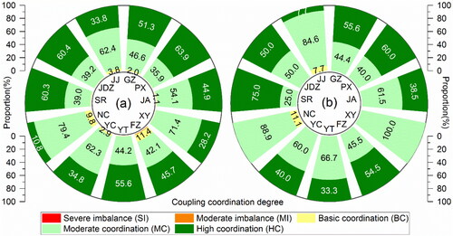
The proportion change of counties and districts with different coupling and coordination levels in each city is that the areas proportion of advantages class (moderate and highly coordinated) in the proportion of counties and districts increases significantly, with only a few cities showing a decrease (). The proportion of highly coordinated counties and districts in Shangrao and Pingxiang is relatively high, with 75% and 60% respectively. Ganzhou (55.6%), Fuzhou (54.5%) and Jingdezhen (50%) also have a higher proportion. The proportion of counties and districts with moderate coordination is significantly higher in Yingtan (100%), Nanchang (88.9%), Jiujiang (84.6%). The counties and districts in the basic coordination category are only distributed in Nanchang and Yichun, with proportions of 11.1% and 7.7%, respectively. The coupling coordination between city and county scales also reflects the distribution state of high coordination in the northeast and south and low coordination in the central region.
4.5. Tourism development and tourism routes
4.5.1. Optimizing the spatial pattern of natural tourism development
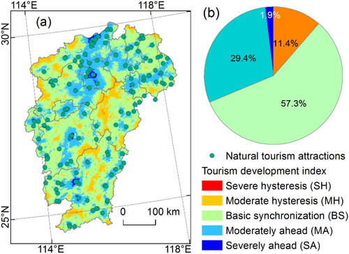
The tourism development index shows that the natural tourism resources and tourism potential in Jiangxi Province are basically synchronized (). There is almost no severe hysteresis (0.02%). The area with moderate hysteresis is relatively small (11.4%, ), distributed in the northwest and southeast mountain ranges, in a strip shape. The area of basic synchronization is the largest (57.3%), mainly distributed in low mountain and hilly areas and more concentrated and contiguous in the eastern and central southern parts. The moderately ahead area is relatively large (29.4%), mainly along the Ganjiang River Valley, Beijing-Kowloon railway and Shanghai-Kunming High speed Railway. The area with severe ahead is also relatively small (1.9%), only distributed near cities in Jiujiang, Nanchang and Ganzhou.
Figure 11. Tourism development in Jiangxi Province. (a) Tourism development index; and (b) area proportion.
The natural tourism development ahead zone should be optimized for development. The potential for natural tourism is high or moderate, there are many existing developments and the distribution of scenic spots is relatively unreasonable, which requires optimization and development. Specifically, there are north central Jiujiang, along the Ganjiang River, along the Beijing-Kowloon railway and along the Shanghai Kunming High speed Railway. Northeast Jiangxi is close to the Yangtze River Delta Urban Agglomerations and is an ideal natural tourism area. The northern of Jiangxi is the area connecting Poyang Lake and the Yangtze River. It is mainly protected and has a good ecological environment. The development mechanism should be further improved. We should raise our awareness of environmental protection and recognize the importance of clear waters and green mountains as golden and silver mountains.
The natural tourism development hysteresis zone should be expanded and developed. Natural tourism has high potential, but with few scenic spots and hysteresis development, it can be a key consideration area for natural tourism development in future. Specifically, there are regions such as the western part of Jiujiang, the central and western of Yichun City, the northeastern of Ganzhou and the western of Fuzhou. The northwest of Jiangxi is the central area of the Yangtze River Middle Reach Urban Agglomerations, which can serve as the ‘ back garden’ of cities in this region. The south and east of Jiangxi (Ganzhou, Fuzhou, etc.) are close to the Guangdong-Hong Kong-Macao Greater Bay Area and the Urban Agglomeration on the West Side of the Straits, which can also be built into a natural tourist destination. These natural tourism development region are mostly economically underdeveloped areas. Reasonable development of natural tourism can not only convert resources and environment into economic value, promote the income for local people, but also accumulate experience for the development of natural tourism in similar regions through development practices.
4.5.2. The implications of natural tourism routes
Scenic spots include natural and cultural relics such as mountains, rivers, lakes, seas, landforms, forests, flora and fauna, fossils, special geology, astronomy and meteorology, as well as cultural relics and historical sites with ornamental, cultural or scientific value. They also include revolutionary memorials, historical sites, gardens, buildings, engineering facilities and other cultural relics, as well as the environment and local customs in which they are located. The number of national scenic spots in Jiangxi Province is relatively small, distributed in four regions: north, northeast, west and southeast. Based on this, four tourist areas can be divided (). The planning of study travel routes can refer to the following: the Nanchang-Jiujiang intercity route in the north, the Jingdezhen-Shangrao-Yingtan intercity route in the northeast, the Ji’an-Xinyu intercity route in the west and the Ganzhou route in the south.
Figure 12. Tourism development and study travel routes in Jiangxi Province. (a) National scenic area; (b) national forest park; (c) national wetland park; (d) national nature reserve; (e) water conservancy scenic area; and (f) overall distribution of natural tourist attractions.
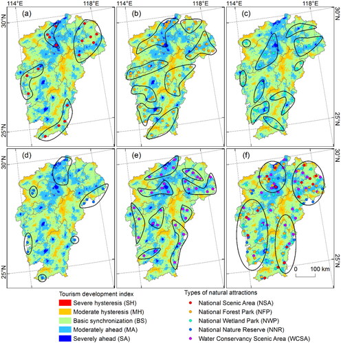
A forest park is a forest that has been renovated for short-term free vacation, or gradually transformed to form a certain landscape system. The purpose of establishing a forest park is to protect all natural environments and resources within its scope and to provide a good environment for people’s leisure, recuperation, summer vacation, cultural entertainment and scientific research. There are a large number of national forest parks in Jiangxi Province, mainly distributed in the transition zone from plains to mountainous hills. Scenic spots in similar or the same watershed can be divided into tourist areas (). The planning of study travel routes can refer to the following: the Jiujiang-Nanchang-Yichun intercity route in the northwest, the Jingdezhen-Shangrao-Yingtan intercity routes in the northeast, the Yichun-Xinyu-Pingxiang intercity route in the central and western regions, the Fuzhou-Ji’an-Ganzhou intercity route in the east and the Ji’an and Ganzhou routes in the south.
The wetland park provides a harmonious wetland natural landscape with water, animals, plants and other elements. It has the important functions of regulating the environment and protecting the ecology. It is a good place for leisure, entertainment, tourism, education and scientific research. The national wetland parks in Jiangxi Province are mainly distributed along river banks, such as the Ganjiang River (flowing from the south to the north) and the Xinjiang River (flowing from the northeast to the north). The same tributary and its nearby scenic spots can be divided into tourist areas (). The planning of study travel routes can refer to the following: the Jiujiang-Nanchang-Yichun-Xinyu intercity route in the north, the Jingdezhen-Shangrao-Yingtan intercity route in the northeast (two route), the Ganzhou route in the south (three route) and the smaller scale Pingxiang route in the west, Ji’an route in the central south and Fuzhou route in the east.
The nature reserve is the epitome of the original natural environment, through which the original State of nature can be restored or approached and plays an important role in protecting the natural environment and natural resources, maintaining the dynamic equilibrium of natural ecology, maintaining species diversity, maintaining the sustainable development and sustainable use of ecosystems and natural resources and protecting the special and valuable natural, human and geographical environment. The national nature reserves in Jiangxi Province are mainly distributed in the north and northeast and can be divided into major tourist areas, while there are a few scenic spots in the northwest, southwest and southeast (). The planning of study travel routes can refer to the following: the Jiujiang-Nanchang Shangrao intercity route in the north, the Shangrao-Yingtan-Fuzhou intercity route in the northeast, the Yichun route in the northwest and the Ji’an-Ganzhou intercity route in the southwest.
Water conservancy scenic spots play an extremely important role in maintaining project safety, conserving water sources, protecting ecology, improving human settlements, stimulating regional economy, promoting environmental education and other aspects. The distribution of water conservancy scenic spots in Jiangxi Province has two types of characteristics: one is the upstream source of the river, and the other is the flat valleys and lakes in the middle and lower reaches of the river. Based on this, they can be divided into tourist areas (). The planning of study travel routes can refer to the following: the Jiujiang route in the north, the Nanchang-Yichun intercity route, the Jingdezhen-Shangrao-Yingtan intercity route in the northeast (two routes), the Yichun-Ji’an intercity route in the west and the Ji’an route, Ganzhou route (two routes), and Fuzhou route in the central, southern, and eastern regions, respectively.
In addition to specialized tourist routes, the same route considers different types of tourist attractions and provides comprehensive education in science, culture, management, history, etc., which is conducive to students’ diversified learning, broadens their horizons and is more in line with educational practice. Natural tourist attractions in Jiangxi Province are concentrated in the north, northeast, west and southeast (), where large-scale and comprehensive study travel routes can be established. It is mainly concentrated on the Nanchang-Jiujiang intercity route in the north, the Jingdezhen-Shangrao-Yingtan intercity route in the northeast, the Pingxiang-Xinyu-Ji’an-Ganzhou intercity route in the west and the Fuzhou-Ganzhou intercity route in the southeast.
5. Conclusion and prospection
The relationship between tourism resources and tourism potential is interdependent. This study analysed the distribution characteristics and natural tourism potential of natural tourist attractions in Jiangxi Province, evaluated the relationship between the two based on a coupled coordination model and proposed future tourism development directions and study travel routes. The results indicate that:
Natural tourist attractions in Jiangxi Province are distributed in various cities, but there are differences. The distribution is relatively dense in the northern and northeastern cities, while the density is low in the southern cities; Natural tourist attractions are mainly distributed at low to medium altitudes and are mainly located in low mountain and hilly areas surrounded by low altitudes, with relatively concentrated areas in the north and scattered areas in the south; The spatial density also shows that it gathers in the north and northeast and is sparse in the south. The density distribution of different types of scenic spots is different; The path distance index of each tourist attraction is distributed in a circular pattern, with higher indices in the north and northeast and closer distances between them.
There is no significant consistency in the distribution of natural tourist attractions and tourism potential evaluation factors, indicating differences in the impact of different indicators.
The evaluation results of ecological environment conditions show that the overall potential of natural tourism gradually decreases from south to north, with the minimum and maximum area ratios being low potential (19.39%) and high potential (30.75%), respectively; The coastal plain of Poyang Lake and the flat zone along the main riverway of Ganjiang River have low potential and are distributed in a concentrated area; The hilly and mountainous areas in the northwest, west, south, east and northeast regions have high potential and are distributed in strips. The evaluation results of socio-economic conditions show that the overall potential of natural tourism is relatively high, with the minimum and maximum area ratios being low potential (1.42%) and high potential (59.45%), respectively; The potential along the north-south Beijing-Kowloon railway and the east-west Shanghai-Kunming High speed Railway is low, showing a cluster belt combination. The comprehensive evaluation results show that the potential of natural tourism gradually decreases from south to north, with the minimum and maximum area ratios being low potential (11.86%) and high potential (39.75%), respectively. The proportion of counties and districts from low potential to high potential is 21%, 23%, 26% and 30%, respectively; The potential along the north-south Beijing-Kowloon railway and the east-west Shanghai-Kunming High speed Railway is low, with the characteristics of cluster belt and contiguous distribution; The hilly and mountainous areas in the northwest, west, south, east and northeast regions have high potential and are distributed in a strip block pattern.
The coupling index is generally high, only lower in small areas in the central northern and southern regions, indicating a significant interaction between natural tourism resources and potential in Jiangxi Province; The coordination index is unevenly distributed between high and low, especially in low altitude areas, indicating that the natural tourism resources and potential in the region are generally mutually constrained, that is, the distribution of the two is inconsistent. The coupling coordination results indicate that natural tourism resources are generally coordinated with natural tourism potential, with low coupling coordination distributed in areas with few existing tourism resources or low natural tourism potential, while areas with high natural tourism potential and relatively more tourism resources have a higher degree of coupling coordination. The proportion of moderately coordinated areas in the province (51.1%) and the proportion of counties and districts (57%) are both the highest, while the proportion of severe and moderately unbalanced areas is close to or equal to 0%; The proportion of highly coordinated areas and county districts is relatively high in Ganzhou (51.3%, 55.6%), Pingxiang (63.9%, 60%), Shangrao (60.3%, 75%) and Jingdezhen (60.4%, 50%).
The tourism development index shows that the natural tourism resources and tourism potential in Jiangxi Province are basically synchronized; The optimized development areas for future natural tourism development are the north and northeast, close to the Yangtze River Delta Urban Agglomerations; The expanded development areas are northwest Jiangxi and southeast Jiangxi, which are respectively close to the Yangtze River Middle Reach Urban Agglomerations and the Guangdong-Hong Kong-Macao Greater Bay Area, Haixi urban agglomeration.
Natural tourist attractions are relatively concentrated in the north, northeast, west and southeast, and thematic and comprehensive study travel routes can be launched in these areas.
This study takes Jiangxi Province, located in southern China, as an example to analyse the distribution characteristics of tourist attractions, evaluate tourism potential and propose study travel routes. The main contributions include (1) evaluating the relationship between the distribution of tourist attractions and tourism potential, (2) spatializing the coupling and coordination pattern of geographical elements and (3) proposing study travel routes based on tourism development characteristics. However, as an exploratory research, there are also issues such as insufficient representativeness in indicator selection and immature study travel route planning schemes. In the following research, it is necessary to focus on a more comprehensive assessment of tourism resources and potential, as well as planning and improving study travel routes in combination with the demand of the study travel market.
Author contributions
Xiaojun Wang: resources, data curation, conceptualization, chart organization, methodology and writing-original draft preparation, writing-review and editing; Yan Xiong: design route of study travel, study travel practice, resources, data curation, chart organization, methodology and writing-original draft preparation; Guangxu Liu: conceptualization, methodology and writing-original draft preparation, writing-review and editing, Funding; Shuyuan Lai, Aicun Xiang and Lihong Meng: resources, data curation, chart organization and writing-original draft preparation. All authors have read and agreed to the published version of the manuscript.
Disclosure statement
No potential conflict of interest was reported by the author(s).
Data availability statement
All data supporting the findings of this study are included within the article. Data will be made available from authors on reasonable request.
Additional information
Funding
References
- Cetin M, Zeren I, Sevik H, Cakir C, Akpinar H. 2018. A study on the determination of the natural park’s sustainable tourism potential. Environ Monit Assess. 190(3):167. doi: 10.1007/s10661-018-6534-5.
- Cheng S, Wang L, Jin J, Huang H. 2020. Factors affecting the willingness of bird-watchers to revisit Poyang Lake Wetland. Chin J Wildl. 41(1):115–124. doi: 10.19711/j.cnki.issn2310-1490.2020.01.017.(In Chinese)
- Dettweiler U, Gerchen M, Mall C, Simon P, Kirsch P. 2023. Choice matters: pupils’ stress regulation, brain development and brain function in an outdoor education project. Br J Educ Psychol. 93 Suppl 1(S1):152–173. doi: 10.1111/bjep.12528.
- Dolby N. 2004. Encountering an American self: study abroad and national identity. Comparative Education Review. 48(2):150–173. doi: 10.1086/382620.
- Duby R, Wahyuningsih E, Anwar H. 2022. Strategies for managing objects and natural attractions in Semongkat Natural Tourism Park, Batulanteh District, Sumbawa Regency. Jurnal Sosains. 2(7):823–831. doi: 10.59188/jurnalsosains.v2i7.442.
- Falk JH, Ballantyne R, Packer J, Benckendorff P. 2012. Travel and learning: a neglected tourism research area. Ann Tour Res. 39(2):908–927. doi: 10.1016/j.annals.2011.11.016.
- Feng ZX, Zhang JX, Hou Z, Zhai L. 2017. Dynamic changes of hemeroby degree based on the land cover classification: a case study in Beijing. Chin J Ecol. 36(2):508–516. doi: 10.13292/j.1000-4890.201702.028.Chinese.
- Geng Y, Chen L, Li J, Iqbal K. 2023. Higher education and digital economy: analysis of their coupling coordination with the Yangtze River economic Belt in China as the example. Ecol Indic. 154:110510. doi: 10.1016/j.ecolind.2023.110510.
- Geng Y, Liu L, Chen L. 2023. Rural revitalization of China: a new framework, measurement and forecast. Socio-Econ Plan. Sci. 89:101696. doi: 10.1016/j.seps.2023.101696.
- Geng Y, Zhang N, Zhu R. 2023. Research progress analysis of sustainable smart grid based on CiteSpace. Energy Strategy Rev. 48:101111. doi: 10.1016/j.esr.2023.101111.
- Irwandi I, Syafri W, Ruhana F. 2023. Strategy for developing natural attractions by the tourism office in Bener Meriah Regency, Aceh Province. Jurnal Scientia. 12(01):482–491. doi: 10.58471/scientia.v12i01.1136.
- Jiang C. 2017. Exploring the potential of ecotourism based on the Fujian Guangdong Jiangxi border region as an example. J Shandong Agric Eng Univ. 34(10):111–112. doi: 10.15948/j.cnki.37-1500/s.2017.10.055.Chinese.
- Kim Y, Kim CK, Lee DK, Lee HW, Andrada RIT. 2019. Quantifying nature-based tourism in protected areas in developing countries by using social big data. Tour Manag. 72:249–256. doi: 10.1016/j.tourman.2018.12.005.
- Lewin R. 2010. The handbook of practice and research in study abroad: higher education and the quest for global citizenship. London; New York: Routledge.
- Li Q, Zhao Y, Li S, Zhang L. 2021. Spatial-temporal characteristics of the coupling coordination of social security and economic development in China during 2002–2018. Region Sustain. 2(2):116–129. doi: 10.1016/j.regsus.2021.04.001.
- Li Y, Zhang S, Han J, Zhao Y, Han Q, Wu L, Wang X, Qiu Z, Zou T, Fan C. 2022. A study of the temporal and spatial variations in the suitability of the environment in Chinese cities for tourism and in strategies for optimizing the environment. Int J Digital Earth. 15(1):527–552. doi: 10.1080/17538947.2022.2041117.
- Lin A, Zhang H. 2023. Research on the development path of study tours for primary and secondary schools based on SWOT analysis: take Shaoxing non-foreign heritage study tour as an example. JID. 3(2):46–51. doi: 10.54097/jid.v3i2.9148.
- Liu G, Xiang A, Wan Z, Zhou Y, Wu J, Wang Y, Lin S. 2023. Variations of extreme precipitation events with sub-daily data: a case study in the Ganjiang River basin. Nat Hazards Earth Syst Sci. 23(3):1139–1155. doi: 10.5194/nhess-23-1139-2023.
- Liu G, Xiang A, Wan Z, Lv H, Liu H, Hu Z, Chen L. 2023. Phenological changes of woody plants in the southern and northern regions of Nanling Mountains and their relationship with climatic factors. Forests. 14(12):2363. doi: 10.3390/f14122363.
- Liu R, Dong X, Wang X, Zhang P, Liu M, Zhang Y. 2023. Relationship and driving factors between urbanization and natural ecosystem health in China. Ecol Indic. 147:109972. doi: 10.1016/j.ecolind.2023.109972.
- Lv Q. 2017. An analysis of tourism efficiency of cities in Jiangxi Province. Nanchang: Jiangxi Normal University. doi: 10.7666/d.D01238432.Chinese.
- [MEPPRC] Ministry of Environmental Protection of the People’s Republic of China. 2015. National Environmental Protection Standard of the People’s Republic of China: technical Specification for Ecological Environment Assessment (HJ192-2015). Beijing: China Environmental Science Press. Chinese.
- Mitchell RD. 1998. Learning through play and pleasure travel: using play literature to enhance research into touristic learning. Curr Issues Tour. 1(2):176–188. doi: 10.1080/13683509808667838.
- Mou N, Jiang Q, Zhang L, Niu J, Zheng Y, Wang Y, Yang T. 2022. Personalized tourist route recommendation model with a trajectory understanding via neural networks. Int J Digital Earth. 15(1):1738–1759. doi: 10.1080/17538947.2022.2130456.
- Nie X, Zhou G, Xie D, Huang Q, Tian L. 2019. Spatial pattern of forest ecotourism development potential in Jiangxi Province based on AHP. Jiangxi Sci. 37(5):685–688. doi: 10.13990/j.issn1001-3679.2019.05.006.Chinese.
- Nofiarli N. 2018. The development of ecotourism model at natural attractions of Tete Batu Village in East Lombok. Sjdgge. 2(1):184–190. doi: 10.24036/sjdgge.v2i1.118.
- Pan Y, Xu J, Hu S, Wen Y, Zou Q, Yan Q, Zeng J, Gu X, Liu Y. 2019. Research on forest health base construction strategy based on SWOT and AHP analysis: a case study of Jiangxi Lushan National Nature Reserve. For Econ. 41(3):40–44. doi: 10.13843/j.cnki.lyjj.2019.03.007.Chinese.
- Pearce PL, Foster F. 2007. A “university of travel”: backpacker learning. Tour Manag. 28(5):1285–1298. doi: 10.1016/j.tourman.2006.11.009.
- Priskin J. 2001. Assessment of natural resources for nature-based tourism: the case of the Central Coast Region of Western Australia. Tour Manag. 22(6):637–648. doi: 10.1016/S0261-5177(01)00039-5.
- Puhakka R, Hakoköngäs E. 2023. Adolescents’ experiences in nature: sources of everyday well-being. J Leis Res. 1–20. doi: 10.1080/00222216.2023.2204346.
- Purwoko A, Thoha AS, Syamsinar. (2021). Analysis of the attractions of Tangkahan Nature Tourism Area, Gunung Leuser National Park, North Sumatra Province. IOP Conf Ser Earth Environ Sci. 912(1):012065. doi: 10.1088/1755-1315/912/1/012065.
- Shang S, Zhong W, Wei Z, Zhu C, Ye S, Tang X, Chen Y, Tian L, Chen B. 2017. Heavy metals in surface sediments of lakes in Guangzhou public parks in China and their relations with anthropogenic activities and urbanization. Hum Ecol Risk Assess. 23(8):2002–2016. doi: 10.1080/10807039.2017.1358078.
- Sujaritchai S, Artnarong W. 2017. Assessment of tourism attraction potentials in 3 eastern borders provinces. Interdiscip Res Rev. 11(6):14–19. doi: 10.14456/jtir.2016.28.
- Tan Y. 2020. Study on the development countermeasures of ecotourism in Poyang Lake Wetland Park. Nanchang: Nanchang University. doi: 10.27232/d.cnki.gnchu.2020.001905.Chinese.
- Tian F. 2016. Development problem and promotion solutions of tourism attractions in Jiangxi based on the boom in central China. Econ Geogr. 36(1):194–199. doi: 10.15957/j.cnki.jjdl.2016.01.027.Chinese.
- Trukhachev A. 2015. Methodology for evaluating the rural tourism potentials: a tool to ensure sustainable development of rural settlements. Sustainability. 7(3):3052–3070. doi: 10.3390/su7033052.
- Wang F, Liu S, Chen T, Zhang H, Zhang Y, Bai X. 2023. How urbanization affects residents’ health risks: evidence from China. Environ Sci Pollut Res Int. 30(13):35554–35571. doi: 10.1007/s11356-022-24767-y.
- Wang J, Abukhalifeh AN. 2021. The influence of study travel on quality-oriented education: the case of Handan, China. Adv Glob Serv Retail Manag. 5:1–15. doi: 10.5038/9781955833035.
- Wang X, Liu G, Lin D, Lin Y, Lu Y, Xiang A, Xiao S. 2022. Water yield service influence by climate and land use change based on InVEST model in the monsoon hilly watershed in South China. Geomat Nat Hazards Risk. 13(1):2024–2048. doi: 10.1080/19475705.2022.2104174.
- Wang X, Liu G, Xiang A, Qureshi S, Li T, Song D, Zhang C. 2022. Quantifying the human disturbance intensity of ecosystems and its natural and socioeconomic driving factors in urban agglomeration in South China. Environ Sci Pollut Res Int. 29(8):11493–11509. doi: 10.1007/s11356-021-16349-1.
- Wang X, Liu G, Xiang A, Xiao S, Lin D, Lin Y, Lu Y. 2023. Terrain gradient response of landscape ecological environment to land use and land cover change in the hilly watershed in South China. Ecol Indic. 146:109797. doi: 10.1016/j.ecolind.2022.109797.
- Wang X, Liu G, Zhang C, Liao Y. 2023. Spatial-temporal pattern and urban-rural gradient of comprehensive ecological security in urban agglomeration in South China from 2000 to 2020. Environ Sci Pollut Res. 30(46):102474–102489. doi: 10.1007/s11356-022-21424-2.
- Wang X, Zhong W, Li T, Quan M, Wang B, Wei Z. 2021. A 16.2-kyr lacustrine sediment record of mercury deposition in Dahu Swamp, eastern Nanling Mountains, southern China: analysis of implications for climatic changes. Quat Int. 592:12–21. doi: 10.1016/j.quaint.2021.04.013.
- Wang X, Zhong W, Wang B, Quan M, Li T, Lin D, Shang S, Zhu C, Zhang C, Liao Y. 2022. Spatial–temporal variations and pollution risks of mercury in water and sediments of urban lakes in Guangzhou City, South China. Environ Sci Pollut Res Int. 29(53):80817–80830. doi: 10.1007/s11356-022-21424-2.
- Wen P, Lu Z, Zhong J, Luo Q, Su Z, Wang M. 2020. Research on the difficulties and countermeasures of study travel in primary and middle schools in Zhaoqing City. Front Educ Res. 3(6):41–44. doi: 10.25236/FER.2020.030613.
- Xiao G, Li W, Zhang C. 2020. Study on spatial structure and influencing factors of Jiangxi tourism route network. Areal Res Dev. 39(5):88–92. doi: 10.3969/j.issn.1003-2363.2020.05.016.Chinese.
- Xu L. 2019. Problems and solutions of the research travel for teenagers in Leshan City. SocialvalSoci. 1(3):16–18. doi: 10.26480/svs.03.2019.16.18.
- Xue E, Li J. 2023. What is the value essence of “double reduction” (Shuang Jian) policy in China? A policy narrative perspective. Educ Philos Theory. 55(7):787–796. doi: 10.1080/00131857.2022.2040481.
- Yan M, Zhao J, Yan S, Zhu M. 2023. Coupling coordination of new urbanization in Chinese urban agglomeration—characteristics and driving factors. Environ Sci Pollut Res Int. 30(55):117082–117095. doi: 10.1007/s11356-023-27469-1.
- Zhang Y, Li W, Li Z, Yang M, Zhai F, Li Z, Yao H, Li H. 2022. Spatial distribution characteristics and influencing factors of key rural tourism villages in China. Sustainability. 14(21):14064. doi: 10.3390/su142114064.
- Zhu J. 2020. Study on tourism environmental impact assessment of Poyang Lake National Wetland Park. Nanchang: Jiangxi University of Finance and Economics. doi: 10.7666/d.y1845140.Chinese.
- Zhu S, Huang J, Zhao Y. 2022. Coupling coordination analysis of ecosystem services and urban development of resource-based cities: a case study of Tangshan city. Ecol Indic. 136:108706. doi: 10.1016/j.ecolind.2022.109149.
- Zuo Y, Chen H, Pan J, Si Y, Law R, Zhang M. 2021. Spatial distribution pattern and influencing factors of sports tourism resources in China. IJGI. 10(7):428. doi: 10.3390/ijgi10070428.