
ABSTRACT
Geodesign theory and practice may be informed and strengthened by studying contrasts between contemporary perspectives and historical processes. In this paper, we disaggregate contemporary geodesign into three trajectories found in the literature: (1) tightly coupled design and impact simulations, (2) a framework for landscape planning, and (3) an organic process. Augmenting these trajectories with two taxonomies of geodesign elements, we look for evidence of geodesign in a longitudinal descriptive case study. Analysis reveals a story of design and planning unfolding over a long period of time at multiple geographic scales interwoven with persistent conflict. The case revealed evidence of geodesign approaches and elements in historical planning and design. The events studied also led to high-quality outcomes that are diffusing regionally. Results of this investigation yield implications for improved geodesign practice and theory including broadening the discourse around geodesign to include time and conflict and expanding geodesign's theoretical frameworks.
1. Introduction and background
At the nexus of the characteristics of place, geography, design, architecture, technology and process, geodesign has become prominent as a hopeful means of using information and communication technology to improve built and human influenced natural environments. However, questions of what is and what is not geodesign are yet to be settled (Tulloch Citation2017), with few well-documented examples of successful, comprehensive geodesign processes or projects as exemplars (Ervin Citation2017).
This article aims to explore geodesign within the context of time by examining a historical case study. We investigate the contemporary understanding and theoretical foundations of geodesign by contrasting the technology and collaboration focus of today's geodesign with a historical planning and design process unfolding in geographic space. Three trajectories of geodesign are compared with a case study of multi-scale design and planning in a coastal community in Queensland, Australia. Acknowledging and reconciling contemporary and historical perspectives presents opportunities for better understanding the geodesign paradigm – as a process, the theoretical frameworks employed and opportunities for enhanced implementation.
We view geodesign as three primary intellectual trajectories or perspectives. The most prominent perspective in the early 2010s was geodesign as tightly coupled design and impact simulations (Kourtit, Nijkamp, and Scholten Citation2015). Secondly, geodesign is a framework for landscape planning – ‘the most widely accepted framework for geodesign’ (Perkl Citation2016, 45). Finally, while less prominent in contemporary discussions, geodesign may be considered as an organic process, especially when incorporating an historical perspective. Geodesign as an organic process provides important background and context to the first two, dominant, contemporary perspectives.
The idea of geodesign as tightly coupled design and impact simulations is implemented in software and planning processes as a recursive feedback between design, spatial analysis and impact assessment. This perspective traces back to the geographic information systems (GIS) software company ESRI from the mid-2000s. The idea of geodesign began to grow at ESRI circa 2004 when a group was tasked with making GIS more suitable for use by designers. Flaxman (Citation2010) provides a widely cited definition of geodesign capturing this perspective, ‘[Geodesign is] a design and planning method which tightly couples the creation of a design proposal with impact simulations informed by geographic context.’ (29). Related definitions include geodesign as input process, evaluation and result (Albert and Vargas-Moreno Citation2012) and, ‘Geodesign is an iterative design method that uses stakeholder input, geospatial modeling, impact simulations, and real-time feedback to facilitate holistic designs and smart decisions’ (McElvaney and Walker Citation2013, 7).
Among ESRI's original goals for geodesign were a GIS sketching interface and tightly coupled feedback models that would allow rapid assessment of design alternatives. Quickly, the idea of geodesign began to be discussed more broadly including beyond the scope of a particular software tool or developer. The aspirational workflow is technology-based real-time feedback on design performance under local conditions that allows iterative changes, refinement and improvement (Flaxman Citation2010). While this perspective features ‘design-thinking’ (Foster Citation2016, 93), the critical feature is the incorporation of technology in rapid or real-time design feedback loops and participatory processes (Albert and Vargas-Moreno Citation2010; Ervin Citation2011; Campagna Citation2014).
ESRI's Geodesign Summit events, held annually since 2009, prominently feature and promote this perspective. Dangermond (Citation2010) argues the geodesign process begins with data and models coupled with interactive design alternatives analysis that then provide rapid feedback on designs and alternatives. ‘This iterative design / evaluation process is fundamentally how the human brain works; we try something, evaluate the results, and move on’ (Dangermond Citation2010, 507). A potential limitation of this approach is a tendency toward a project specific focus.
The intellectual roots of this perspective go back to the incorporation of GIS technology and planning as conceived in the late 1980s and 1990s. While not using the term ‘geodesign’, Harris (Citation1989) linked iteration and improvement in planning, to optimization processes both generally, and within sketch planning and scenario planning. Harris (Citation1989) also linked the ideas of design, impact and the idea of optimization through iterations. Whereas early GIS had little capacity for iteration, GIS scripting and graphical modelling tools now enable iterative and recursive analytical processes. Wider availability of digital spatial data and other processing tools also contribute to advances in GIS technology that facilitate design, experimentation and iteration. Recent development of GIS-based planning support systems enables scenario planning, sketch planning and related impact assessment.
Geodesign is frequently operationalized as a framework for landscape planning. Building on ideas he originally put forth more than 20 years before, Steinitz provides the definitive statement on this perspective by presenting a framework for geodesign applied to landscape architecture (Steinitz Citation1990; Citation2012). Steinitz presents his framework as an organized way to collaboratively ‘do’ geodesign; iteratively asking questions and selecting and applying methods in pursuit of the best possible outcomes (Steinitz Citation2012). The Steinitz framework is an integration of concepts, design strategies, procedures and techniques as well as implementation details including the use of models to describe a planning process, all of which is interwoven with expert and stakeholder participation. The Steinitz framework is strongly influenced by systems thinking (Steinitz Citation2016) and scale (Steinitz Citation2008) where large scale (large area) is associated with strategy and relatively high risk and small scale (small area) is associated with details and low risk. Design, analytical and planning processes also change with scale.
A recent implementation of the Steinitz framework is presented by Pettit et al. (Citation2019) who explore the role of the geodesign process within a workshop setting for South East Sydney, Australia. Strengths of the Steinitz framework emerging from the workshop were process focused. Face-to-face collaboration and negotiation augmented with technology worked well for engagement and helped to develop ideas which could overcome limitations to narrow and fragmented approaches to planning typical in the study area. There was also a balance between the linear flow of the workshop and geodesign process with non-linear collaboration and networking.
Geodesign as an organic process stems from thoughtful commentary and historical perspective. Among the first uses of the term was in the early 1990s to indicate cartographic sketches or scenarios (Kunzmann Citation1993; Miller Citation2012). Numerous authors link geodesign with the work of Sir Patrick Geddes, Frank Lloyd Wright, Neutra, and McHarg (Dangermond Citation2010; McElvaney Citation2012; Miller Citation2012; Paradis, Treml, and Manone Citation2013; Ervin Citation2017). Miller (Citation2012) further expresses the idea that geodesign is a reconfiguration of the landscape analysis ideas of McHarg and the landscape planning ideas of Steinitz coupled with technologies, usually GIS, that enable digital design in geographic space. This illuminates an important connection between older practices which fit well within the definitions and spirit of geodesign and technology oriented geodesign as iterative and recursive feedback processes. Similarly, Campagna and Di Cesare (Citation2014) note the link within geodesign between technology, participatory and collaborative process and argue that based on the latter geodesign is ‘not entirely new’ (199). Geodesign is then only partially a new name for old practices.
Miller (Citation2012) presents a cornerstone idea of geodesign, that geographic space influences both how and what people design as well as how people adapt to their surroundings, an idea that, ‘has been with us since the beginning of time’ (4). Similarly, Ervin (Citation2011) refers to geodesign as, ‘the current manifestation of an age-old practice – planning, designing, implementing and evaluating changes to our built and physical environment’ (145). Differing views of geodesign as an organic process include, ‘all geodesign in my view is fundamentally the process of arranging objects – such as trees, forests, houses, cities, transportation systems, et al. … ’ (Ervin Citation2012, 26) and as a vision for incorporating geographic knowledge in design processes (Dangermond in Steinitz Citation2012).
In practice, there are a small handful of geodesign projects that incorporate historical perspectives. Kolen, van Manen, and de Kleijn (Citation2014) consider geodesign through the lens of history. They argue strongly that both current processes and impacts of new interventions can be best understood within the context of historical processes. Burgers, de Kleijn, and van Manen (Citation2014) argue that classical archaeologists ‘have much to offer to modern spatial planning and design’ (183) and can contribute to the iterative and recursive steps in geodesign workflows. Campagna and Di Cesare (Citation2014) looked for coherence in geodesign and its elements by investigating current and historical regulatory frameworks in Italy.
Most scholarship on geodesign relies on collaborative process for a theoretical underpinning. Innes (Citation1995) provides a broad overview, geodesign examples include Pettit et al. (Citation2019); McElvaney and Walker (Citation2013); and Ervin (Citation2011). There are limited exceptions to this trend. Gu and Deal (Citation2020) integrate a resilience based adaptive cycle into their geodesign framework. Newman et al. Citation2020 frame their investigation within socio-ecological system (SES) disturbance concepts, vulnerability and resilience. For planning and design, ideas of cause and effect where small area changes are linked to landscape scale changes are presented by ESRI (Citation2010) and McElvaney (Citation2012). Causal links between human action and landscape change harken back to the early twentieth Century where the idea of landscape emerged as a generalization of individual scenes which to be understood must be seen as organic and dynamic rather than static (Sauer Citation1925; Bluntschli Citation1921).
In order to reconcile varied definitions of geodesign as well as investigate the boundaries and structure of the field, Tulloch (Citation2017) presents a taxonomy of geodesign practice comprising three classification criteria: 1. inclusion of computers in design processes, 2. inclusion of modelling and, 3. public participation. The taxonomy reveals heterogeneity in contemporary practice based on different combinations of three classification criteria. Similarly, Ervin (Citation2017) presents a structure for geodesign by augmenting his definition of the field with required elements: digital data, information processing, computing and algorithmic processes, collaboration, simulations and evaluation, spatial and temporal impacts analysis, environmental design and systems thinking. The environmental design component incorporates a normative perspective, ‘the ethics and attitudes of environmentalism’ (85). Reflecting on his definition and requirements, Ervin (Citation2017) notes, ‘we do not yet have many good examples of full-blown geodesign processes or projects that satisfy all points of this definition’ (85). Ervin (Citation2017) also presents a broader, ‘key characteristic of geodesign … designing and design-thinking, together with geospatial analysis’ (86).
Given three trajectories of Geodesign (a recursive feedback process between design and spatial analysis, a framework for landscape planning, and an organic process) augmented with emerging frameworks that help structure the field, we investigate the contemporary understanding and theoretical foundations of geodesign by exploring a historical example of place-specific design in contrast to the largely technology-enabled geodesign principles at the forefront today. Specifically, to what extent does historical planning and design align with the trajectories and frameworks of contemporary geodesign? Similarly to Kolen, van Manen, and de Kleijn (Citation2014), we take a descriptive case study approach to look for evidence of geodesign in the 50 + year long story of multi-scale design and planning in Noosa, Queensland, Australia, a highly planned built and natural landscape.
2. Case study and methods
A case study method was employed to analyse a 50-year, place-specific history of development, design and conservation describing the processes and elements involved in working toward creating a sustainable local and regional community of lasting value. As presented in Yin’s (Citation2018) delineation of case study research design elements, a single-case, descriptive case study was developed. The nature of key recent and past planning actions in the Noosa study area were evaluated against tenets of the geodesign trajectories and the Tulloch (Citation2017) and Ervin (Citation2017) taxonomies to expand geodesign theory and inform future geodesign practice.
The choice of Noosa in part reflects the fact that the locale has previously been held as an exemplar case for better understanding coastal engineering (Wishaw et al. Citation2020), growth management (Barclay and Davis Citation2014), historic preservation, tourism development, and place (O’Hare Citation2001). A priori and in accordance with case research best practices outlined by Flyvbjerg (Citation2006), case development was approached as being ‘critical’ – to verify or disqualify a particular condition, in this case the historical presence of geodesign elements, and ‘paradigmatic’ – focused on highlighting general qualities, rules, or behaviors of the subject in question, planning processes in Noosa from the early 1960s through the first decades of the twenty-first century.
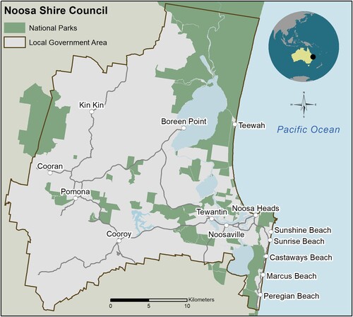
The community of Noosa, located approximately 140 kilometers north of Brisbane on the east coast of Australia, is widely known as an international tourist destination. Noosa is recognized for its livability, recreation appeal, successful community planning and environmental management (Denby, Tilbury, and Cerone Citation2007). The year-round temperate climate is complemented with some of the best beaches and surfing in Australia. The Noosa Shire Council Local Government Area (LGA) is 900 square kilometers with a population of 56,298 (ABS Citation2021). It includes the more densely populated coastal communities of Noosa Heads, Noosaville and Tewantin, as well as the rural inland communities of Cooroy, Kin Kin, and Pomona (). While early European settlement centered around timber harvest, tourism has been a part of the region since the 1890s.
Figure 1. Noosa Shire Council Local Government Area.
Calls for sustainable growth and responsible planning have long competed with pro-development private sector interests enabled by growth friendly policies in Noosa. Resort-oriented development accelerated from the late 1920s; by the 1960s the area included some of the most expensive coastal real estate in Australia (Centre for the Government of Queensland Citation2018). In 1929, Australia's first statutory plan was produced for the Sunrise Beach portion of Noosa, unexpectedly emerging at the instigation of a land development company rather than by municipal edict (Baker Citation2012). A dedicated town planner position was authorized in the late 1960s (Cato Citation1989), and Noosa's first formal town plan, including the first provisions for restricted building heights in the community, was implemented in 1973 (Queensland Government Gazette Citation1973). Noosa's first shire-wide strategic plan was enacted in 1988 (Noosa Council Citation1988). The 1997 strategic plan update (Noosa Council Citation1997) took the innovative step of implementing a population-based ‘development cap’ based on the environmental carrying capacity of the land (Fullarton Citation2007). The development cap was reinforced by the Noosa Plan 2006 (Noosa Council Citation2006). In 2007, the Noosa LGA was designated as a UNESCO Man and Environment Biosphere Reserve. While Noosa's UNESCO designation recognizes its unique and special natural attributes, it also provides a focus for the community's aspirations to achieve and maintain a balance between environment and sustainable human development (Noosa Biosphere Reserve Foundation Citation2018). In July 2020, the Noosa Plan 2006 was replaced by a new 20-year planning scheme, Noosa Plan 2020 (Noosa Council Citation2020).
Intermingled with these planning successes, local authors write of both damage and threats from pro-development Noosa Councils throughout the 1960s, 1970s, and 1980s. Damages included impacts on Noosa main beach and nearby rainforest. Threats included canal estate development, high-rise development, strains on local services, sand mining, peat mining, an ocean sewage outfall, and poor overall design of the built environment (Edwards Citation2001; Gloster Citation1997; Cato Citation1989). The solution to these damages and threats was to re-think what was then, ‘the conventional wisdoms about conservation, town planning and community development’ (Gloster Citation1997, 11).
In contrast, the pro-development perspective within the case is exemplified by Sharpe (Citation2015), where major emphasis is given to the enabling value of infrastructure construction, particularly roads and bridges in creating the Noosa community. Sharpe advocates that growth in Noosa should be dictated by the market and not government-backed growth management policy. Nevertheless, he acknowledges the sensitivity of certain Noosa area environments including the Hastings Street beach front and points out a developer commitment to native vegetation-based landscaping and innovative stormwater drainage solutions. Sharpe also describes a design proposal (though eventually abandoned) for a residential development on Noosa's Lake Weyba modeled after the McHarg inspired Woodlands development outside Houston, Texas. Sharpe presents a historical position on development in Noosa that can be interpreted as fundamentally valuing development over conservation-oriented design and viewing environmentalist preservation attitudes as privileged NIMBYism.
The combination of planning and design success along with controversy and conflict suggests Noosa is a rich single case example that lends itself well to a contextual examination of historical geodesign. We use a descriptive case study approach to examine planning and design in the built and natural environment over time for the purpose of identifying the presence, absence and influence of contemporary geodesign ideas in historical land-use decision making and associated outcomes. We posit that acknowledging and reconciling contemporary and historical perspectives presents opportunities for better understanding the geodesign process, the theoretical frameworks employed and opportunities for enhanced implementation. Three long-term planning processes are examined in the case: (1) the evolution of design for Hasting Street and Main Beach; (2) coastal engineering involving Main Beach and the Noosa River entrance; and (3) the establishment and expansion of Noosa National Park.
3. Geodesign in retrospect
3.1. Hastings street and Main Beach
Hasting's street (), adjacent to Noosa Main Beach and the main tourism, shopping and restaurant district in the region, was the focal area in the shaping of Noosa in the late 1970s. The story begins with a transition from pre-war Queensland coastal architecture to strongly critiqued brick and tile architecture of the 1950s, 1960s and 1970s. By the late 1970s there was little left of pre-WWII architecture and little of Hastings Street that had any design merit (Cato Citation1989; Gloster Citation1997).
Figure 2. Hastings Street circa 2009 (Image courtesy of John Gollings Photography http://www.gollings.com.au/).
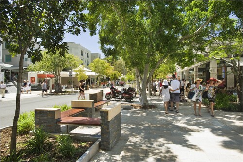
Figure 3. Main Beach, Buildings along Hastings Street and vertical development on the slopes near Noosa National Park (By Hypervision. Used under License).
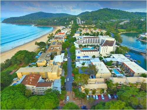
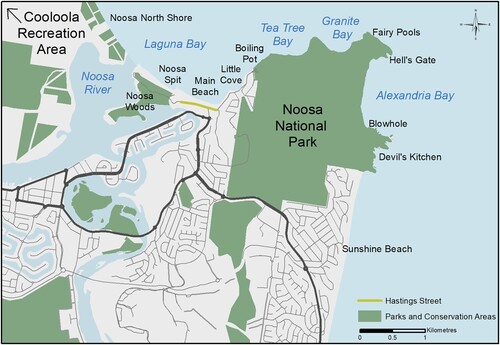
Figure 4. Noosa National Park map and nearby protected areas.
The late 1970s were a four-sided battle between (1) developers seeking to make quick profits, (2) a developer looking to build an expansive Hawaiian style resort, (3) businesses more concerned about making money than about any specific developments, and (4) a citizens group who saw development pressure as leverage to shape a world-class beachside destination (Gloster Citation1997; Edwards Citation2001). The latter group would subsequently play a strong role in local government and community design. The group's vision was for diverse and complementary architecture, multiple owners (versus a limited number of large resorts), and quality design enhanced by landscaping and streetscaping.
Threats associated with development led to a series of participatory seminars and workshops in the late 1970s and early 1980s. A three-day seminar in April 1979 was focused on developing Noosa into the 1980s. Topics included conservation, planning, building and high-rise development, landscaping, tourism and Hastings Street (Edwards Citation2001). Emerging from the workshop, the benefits of design and planning were highlighted in the local newspaper, ‘Design is the opposite of accident, and planning is the avoidance of irreversible mistakes’ (cited in Edwards Citation2001, 181). A follow-up seminar in June 1980 focused on regional environmental issues including the Noosa River and upstream catchment, the Noosa North Shore, and a proposed national park just south of Noosaville surrounding a large lake (shown in ). Together, the seminars provided citizen input on how people wanted the area to develop both to local elected officials as well as to the broader public. ‘The pressures which had been placed on the council in determining guidelines for the unprecedented development in the 70s would no longer exist in the 80s’ (Edwards Citation2001, 181).
Two members of the citizens group active in the 1970s, Playford and Gloster, were elected to Noosa Council in 1982. As councilors they sought to develop a policy and planning framework that encouraged landscape and design excellence built around economic and ecological sustainability (Cato Citation1989). Among their first areas of focus was refining a vision for Hastings Street where it would become the prime attraction of the community and not a ‘rock-wall compromised beach’ (Gloster Citation1997, 90). This led to a focus on both Hastings Street and the connections with Noosa National Park to the east and the Noosa Spit and Noosa Woods to the west.
At the time of the election of the 1982 council, Gloster, dissatisfied with what he saw as a lack of foresight and a lack of leadership arranged a council convened workshop for Hastings Street stakeholders in order that they would collaboratively design and develop a personal stake in creating an intentional future. He describes workshop outcomes as a ‘breakthrough’ (Gloster Citation1997, 45) where a despondent atmosphere turned to a commitment to high quality design. Ideas emanating from the workshop included preserving a village atmosphere for Hastings Street, promoting architectural diversity, viewshed protection, protection of nearby open space, improved pedestrian access through Hastings Street and to nearby natural areas as well as a high-rise ban. Another outcome of the workshop was a draft Hastings Street Development Control Plan which formalized the core planning, design, landscaping, streetscaping and connectivity principles that make Noosa what it is today (Gloster Citation1997).
The vision for this council was consolidated into the Noosa Shire Council Design Manual (Noosa Council Citation1986), focused on ‘the visual appeal of the street environment and its interface with private development’ (Sanderson Citation2015, 9). The principles put forward related architecture and design to context, advising compatibility and visual unity with the shape, topography and other characteristics of nearby sites. Continuity of character using design could be realized in part by the selection of similar and compatible materials and the use of natural colors that blend the built environment with the natural landscape. The principles articulate the character, amenity and liveability value of trees alongside appropriate plant selection in a sub-tropical climate and consideration of local environmental factors in landscaping. Specific to Hastings Street, the principles encourage outdoor dining and store displays including pedestrian flow along sidewalks. Design details expressed in the principles included sign design, size, maintenance, placement and density (Noosa Council Citation1986).
Neither Playford nor Gloster were re-elected in 1985. The defeat provided a lesson, ‘Authentic community consultation not only enables councilors and community to explore options together, and to learn together. It also provides opportunities for those with vested interests to hijack and eventually stalemate the consultation and decision-making process’ (Gloster Citation1997, 47). The subsequent 1985-1988 council was described by Gloster (Citation1997) as, ‘development-at-any-cost adventurism’ (67), though conversely described as ‘progressive’ by Sharpe (Citation2015, 208). This new council sought an ocean sewage discharge, approved a six story-resort development on the Noosa Spit and approved a vertical, hill climbing, development along the hills at the eastern edge of Hastings Street bounding the national park (Gloster Citation1997; ).
By 1987 the proposed Noosa Spit resort was cancelled and, in part through advocacy of the Noosa Parks Association, the Queensland government declared the spit to be a public park. Permanent protection of the spit caused bitterness in the business community but led the Playford Council to see the importance of transformational work on Hastings Street and that the nearby woods and spit should be maintained in such a way as to integrate recreation, conservation and business interests (Cato Citation1989; Gloster Citation1997). Final project results, including landscaping and streetscaping along Hastings Street, restoration of the Noosa Spit and Noosa Woods and development of high-quality pedestrian connections between Hastings Street and the nearby natural areas boosted business confidence, providing an example, ‘that enlightened conservation and enlightened business could proceed hand in hand’ (Gloster Citation1997, 107).
Through 1988 a number of six story buildings were approved. However, after seeing the results, the community was once again ready to vote for a council that would ban high rise buildings (Gloster Citation1997). Playford was re-elected to council in 1988 and re-oriented the local government to see Hastings Street as the core of the local economy and an ideal location for demonstrating conservation and landscaping projects. The philosophy was to step away from conservation and development as a dichotomous choice and instead, make ‘Noosa a great place to live, so that economic development would follow’ (Gloster Citation1997, 82).
Three Playford-led councils, starting in 1988 and proceeding through 1997, enacted planning and design reforms including limiting building heights to two stories in most of the local government area and four stories in limited areas along and near Hastings Street. Landscaping and streetscaping set the example for quality design in the built environment and promoted conservation. Part of the issue in pursuing quality community design in and around Hastings Street while maintaining a pedestrian and village feel was to take a strong position on motor vehicle access and parking. Under continuous calls for more parking and roads, the solution was to design roads and parking to meet ordinary use levels rather than peak demand. An additional aspect of maintaining the village-like feel of Hastings Street was protection of the remaining viewshed on the hills to the east. The 1988–1991 Playford Council was able to establish a development control plan for the area. Once a banana farm, the area visible from Hastings Street is now regenerated while additional development rights were granted on former banana farmland not visible from Hastings Street (Gloster Citation1997). This work resulted in the 1997 Noosa Shire Strategic Plan (Noosa Council Citation1997) which aimed to protect both the Noosa lifestyle and environment by focusing on the carrying capacity of both infrastructure and the environment. The plan limited population by controlling land use and limiting the number of land titles (Denby, Tilbury, and Cerone Citation2007; Fullarton Citation2007).
3.2. Coastal engineering
The story of the ‘engineering’ of Noosa Main Beach and the Noosa River mouth complements the development and re-design of Hasting Street, the Noosa Woods and Noosa Spit. As shown in , Noosa Main Beach is located between Noosa National Park and the Noosa River. Beach erosion is a natural process at Noosa Main Beach, with more pronounced cutback occurring with major storm events. However, prior to the 1960s, the beach and adjacent Noosa River estuary system maintained a state of dynamic equilibrium. Although storm events disrupted the system at times, the protective dunal system of the Noosa spit in its natural state facilitated recovery without long-term concern to existing human settlement (Jackson, Black, and Tomlinson Citation1999; Chamberlain and Tomlinson Citation2006).
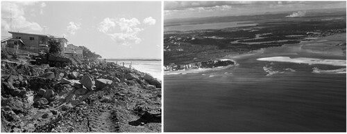
Following several high-intensity, closely spaced cyclones in the summer of 1967–1968, Hastings Street property owners haphazardly ‘began a panic dumping of rockfill in front of their properties, on the beach itself’ (Cato Citation1989, 71). Noosa Council and the Queensland Government followed by constructing a more uniform rock revetment wall the length of the beach to the Noosa River mouth (). Unfortunately, the rock wall was located in the swash zone, the area of turbulent water after a wave breaks on a beach, and out of alignment with sand nourishing wave crests (Coughlin Citation1989; Chamberlain and Tomlinson Citation2006). Additionally, plans to pump sand behind and over the wall onto the beach to create a mitigating sand dune were abandoned due to budget constraints (Cato Citation1989).
For the first time, the cycle of erosion and accretion which had regular(cited in Edwards Citation2001 p. 181)ly occurred at Noosa and which had always ensured an all-tidal beach was interrupted by human intervention. The beach, which was the catalyst that had attracted property development to Hastings Street, was suddenly denied its natural mechanism to recover (Coughlin Citation1989, 3).
Figure 5. Rock wall construction circa 1968 (left) and complete rock wall 1972 (right; grey line in the swash zone to the left of the river mouth). (Images c/o Noosa Library Service https://www.libraries.noosa.qld.gov.au/picture-noosa).
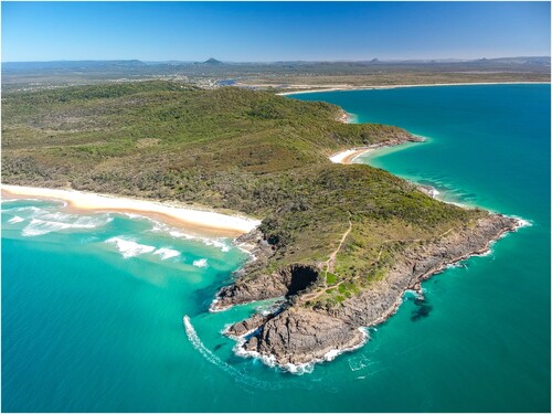
3.3. Noosa National Park
The story of Noosa National Park is the story of natural, and in comparison with Hastings Street, large scale landscape design. The protected area shown in and was assembled in a series of land acquisitions and amalgamations. Early European settlers informally set aside a reserve to protect the Noosa Heads area in 1879. Noosa National Park was created in 1939 in order to protect two small areas of rainforest, one near the park entrance and another near Tea Tree Bay. Noosa Hill linked the two patches of rainforest and was also protected. In the early 1960s the entire coastline of the area was privately owned and leased to developers, slated for lease or set aside as road reserve. At that time the Noosa Park's Association had a goal of ensuring the five kilometres of coastline were left undeveloped and added to the national park. In 1962 the Association asked State Government to expand the national park to include the coastline and other government owned land at the end of Alexandria Bay. The government refused. After an aggressive public education program put forward by the Association and severe pushback from the Council, the State Government agreed to protect the area from the end of park road (near Little Cove) to Hell's Gate. These were added to the national park in 1964. The Association then sought to extend the park from the government owned land at the northern end of Alexandria Bay westward. Again, the State Government rejected the suggestion and the Association put forward an aggressive public education program. The government changed their view and added this piece to the park in 1967 (Edwards Citation2001, O’Hare Citation2001).
Figure 6. Noosa National Park (centre), Cooloola Recreation Area (upper right) and surrounding landscape facing southwest (By Guille. Used under License).
The remaining area around Alexandria Bay was owned by a development company seeking to build a resort complex and residential subdivision (Sharpe Citation2015). However, they lacked road access to their land. The Association sought to prevent road access for the developer to their property. A key parcel involved in the controversy was a piece of State Government land set aside as a water reserve. The Association successfully lobbied the government to have the water reserve added to the park in 1972. A final inland piece was added to the park in 1988.
Cooloola Recreation Area on the north side of the Noosa River also experienced a contentious history ( and ). In contrast with Noosa National Park, conflicts were less about real estate and more about natural resources development including sand mining. After similar contentious processes major additions to what was then Cooloola National Park occurred in 1963, 1975, 1985 and 1991. In total, the Headlands area of Noosa National Park protects about 440 hectares and Cooloola Recreation Area approximately 59,000 hectares. The establishment of these two substantial parks meant the community was bounded by undevelopable land to both the east and west, creating, ‘a natural and permanent barrier against development’ (Gloster Citation1997, 50). By limiting developable land along with other town planning policies and laws as well as complementary economic development policies, the 1988 Playford Council viewed their goal of a population limit as accomplished (Gloster Citation1997).
3.4. Noosa today
The contemporary version of Noosa's design guidelines is put forward in Noosa Design Principles: How Noosa Has Been Shaped (Sanderson Citation2015). The guidelines are a mix of aspirations and detail pertaining to both the built and natural environment. General aims include growing the economy while protecting what residents and visitors love about the community, the natural environment and quality of life. The document includes implementation approaches such as developing understanding by considering context, not viewing projects in isolation, and aligning development with planning. Community participation is encouraged in both planning and design. Large scale design goals include a transportation network that provides high levels of off-peak service, spreading traffic across the network and not sacrificing open space for parking. Small scale design considerations include not permitting high rise development, parking meters, or obtrusive billboards.
It is interesting and important to note, the ideas developed in Noosa are diffusing regionally as seen in development of a 50-km coastal pathway as well as in the adjacent Sunshine Coast local government area's design strategy (Sunshine Coast Council Citation2020) which incorporates many of the concepts developed in Noosa. Further potential diffusion of the ideas is likely as the design strategy is winning both state and national awards. The coastal pathway crosses three local government areas including Noosa council. Construction began in the 1990s with a vision for the project to be a world-class scenic connection between communities (Sunshine Coast Council Citation2017).
Another long-term positive impact includes the 2020 designation of Noosa as a World Surfing Reserve encompassing Noosa national park and extending west to the mouth of the Noosa River. The intention of the program is to, ‘preserve outstanding waves, surf zones and surrounding environments around the world (Noosa World Surfing Reserve Citation2020). This reflects the broader extension of geodesign principles elsewhere into marine environments as presented by McClintock (Citation2013) and Burnett (Citation2020).
4. Interpreting Noosa planning through the geodesign lens
Noosa is a story of threats, damages, problems, planning, conflict and resolution augmented with process considerations and design solutions both similar and different to the three trajectories of geodesign featured in the literature. We looked for and found numerous examples of geodesign in the Noosa story. Planning and design as solutions to problems and as means of bringing about a better future have been seen in Noosa for decades and are well aligned with all three trajectories. Similarities between planning and design processes in Noosa and the tightly coupled design and impact simulations trajectory include informing ideas with geographic context and iterative and incremental refinement and improvement. The Noosa case is replete with examples of geographic context influencing planning and design, ranging from coastline orientation to the global and local dynamics of tourist behavior. Examples of refinement and improvement include park assemblage via a series of land acquisitions as well as the ongoing story of beach erosion and river management. Planning and design elements – ranging from choice of building materials, landscaping and streetscaping through viewshed protection and the use of national parks as both amenity resources and buffers against development reflect community efforts to plan across multiple geographic scales. Complementary small-scale design elements and large-scale landscape protection invoke the considerations of scale featured in the Steinitz framework. Links to organic processes include the age-old practice of planning, implementing and evaluating changes in the environment (e.g. Noosa's population-based development cap based on environmental carry capacity) as well as arranging objects and systems in geographic space, e.g. the evolution in design of Noosa's infrastructure (roads, utilities, etc.). These comparisons illuminate an important connection between older practices which fit well within the definitions and spirit of geodesign and technology oriented geodesign as iterative and recursive feedback processes.
Findings here may be compared with Tulloch’s (Citation2017) three geodesign classification criteria and taxonomy of practice. While the history of planning and design in Noosa shows little evidence of Tulloch’s (Citation2017) first criterion, the inclusion of computers in design processes, the case is congruent with Tulloch’s (Citation2017) taxonomic evaluation where only 13 of 28 projects used a computer as a designer in some way. In Noosa, this appears to be changing. Trends indicate the community is moving toward greater inclusion of technology in planning and design. The 2020 Noosa Plan includes an interactive mapping website with a variety of data layers including a time series of aerial photos and other base maps, administrative boundaries, spatial products from the broader regional plan, as well as series of layers on economy, employment, infrastructure, transportation, land use, biodiversity, hazards, natural resources, parks and amenities (Noosa Council Citation2020). The extensive collection of layers invites ‘what if?’ type questions and therefore presents both supporting data and a potential conceptual foundation for computer augmented design thinking. Tulloch’s (Citation2017) second classification criterion, planning and design relevant modeling, is seen in Noosa in the response to the challenges of coastal engineering. Modeling of the beach and river system is used to better understand sand transport and dredging impacts with the goal of informing long-term beach management (Chamberlain and Tomlinson Citation2006; Wishaw et al. Citation2020). To the third criterion, planning and design in Noosa incorporate many examples of participatory processes including the workshops of the late 1970s and early 1980s as well as the 1982–1985 Noosa Council initiating open meetings.
The history of planning and design in Noosa shows similar alignment with Ervin’s (Citation2017) requirements for geodesign. Even with Noosa's long planning history, examples of digital data, information processing, and computing exist but are limited. Simulation and evaluation, spatial and temporal impacts analysis and systems thinking are seen in coastal engineering. Scaffolded development of both Noosa National Park and the Cooloola Recreation area as well as the planned and realized synergies between enlightened conservation and enlightened business are examples of systems thinking. Collaboration and consultation among citizens, business and government are a recurring part of the unfolding Noosa story. Pro-environmental perspectives also feature prominently in the influences and outcomes of planning and design processes. While environmental awareness and quality of life have long been a draw to Noosa, links between environmental awareness, quality of life, planning, design and their influences on decisions made in the shire became clear in the late 1970s and continue into the third decade of the twenty-first century.
5. Conclusion
The Noosa case, in linking the three trajectories and two taxonomies reflects the multidisciplinary nature of geodesign; a flexible, iterative and multi-scale amalgamation of geography, planning, design, and engineering. Historical planning and design align well with the trajectories and frameworks of contemporary geodesign. Noosa aligns well with contemporary geodesign where thoughtful change facilities refinement and improvement. The historical perspective also highlights the novelty of contemporary geodesign approaches where the emphasis is stakeholder engagement augmented with iterative and recursive design and impact simulation.
Results of this historically-oriented descriptive case study support the findings from Kolen, van Manen, and de Kleijn (Citation2014)'s investigation into geodesign from the perspective of history and landscape. We found geodesign processes operate on multiple geographic and temporal scales in Noosa. Spatial scales extend from site-specific detailed designed considerations to the regional arrangement of built and natural areas. Temporal scales range from the immediate, for example the traffic impacts on the afternoon of a holiday weekend, to the long term as suggested in decades long trends in architectural changes and geomorphological changes associated with the Noosa River. We also found path dependencies from past human decision and action. Central to the Noosa case was the establishment of design concerns and environmental stewardship in the late 1970s that continues to influence planning and decision making as well as built and natural environment outcomes today.
There are dissimilarities between the Noosa story and the contemporary geodesign trajectories. The geodesign literature tends to look at collaboration and stakeholder engagement as the predominant theoretical construct in which geodesign sits. Both the geodesign literature and the Noosa case demonstrate positive impacts from collaboration and stakeholder engagement. In Noosa, this includes residents, architects, designers, community groups and local government (Sanderson Citation2015). However, issues such as building heights, population limits, national park expansion, and economic development indicate that community design and planning can be a contested space. Lessons from Noosa's history augment the predominantly positive perspective on collaboration in contemporary planning. In Noosa, geodesign is both collaboration and conflict:
Noosa doesn't look much like a battleground, unless you look at it with an insider's knowledge. The tracts of green rising up from the coast, the shady walkways, the public parklands, the treetop skyline, even the alfresco cafes dotted along Hastings Street and the riverfront … each represents a battle fought and won by the residents of Noosa over the past two or three decades … (Jarrat in Gloster Citation1997, 7).
Acknowledging conflict and extending the time horizon of geodesign allows for consideration of philosophical influences beyond collaboration and opens the possibility to more thoughtful and improved spatial interventions. These could include more appropriate designs, better decisions and improved built and natural environment outcomes. This applies to small and large temporal scales as well as small, large, and global spatial scales. For these reasons, we recommend an extension of geodesign thinking, potentially including Tulloch’s (Citation2017) criteria and Ervin’s (Citation2017) definition and supporting requirements to include theory basis. Consideration of whether a project is based in theories of collaborative process, landscape theory, social-ecological systems disturbance concepts or other frameworks will both help practitioners and academics better understand the diversity and structure of the field.
The case also addressed the need for more well-documented examples of successful, comprehensive geodesign processes (Tulloch Citation2017) and projects as exemplars (Ervin Citation2017). We recommend that future geodesign research continues to incorporate case study methods to develop these examples, some of which may include looking toward the past. Similarly to Kolen, van Manen, and de Kleijn (Citation2014)'s recommendation to encourage archaeologists, historians and landscape geographers to join geodesign projects, we encourage the planners, designers, landscape architects and geospatial technology specialists currently working in geodesign to consider the potential contributions of and invite those in the first group to become project collaborators.
Results of this investigation yield implications for improved geodesign practice and theory including broadening the discourse around geodesign to include time and conflict and expanding geodesign's theoretical frameworks. Noosa is an unfolding story of threats, compromises, successes and failures, as well as sustainable growth, responsible planning and citizen engagement that reflects a spirit of geodesign unfolding over the last 50 years. The story of Noosa, however, is also how opportunities were seized and threats were resolved to make the well-designed mix of built urban and natural landscapes Noosa is today. Accordingly, design in geographic space was, and continues to be, part of the solution.
Acknowledgements
The authors thank Jane Harding, Heritage Coordinator, Noosa Council, for finding and sharing a copy of the oft-referenced 1973 Noosa town plan. Co-author Hamerlinck's participation in this research was supported in part by funding from the Global Engagement Office at the University of Wyoming.
Disclosure statement
No potential conflict of interest was reported by the author(s).
References
- Albert, C., and J. C. Vargas-Moreno. 2012. “Testing GeoDesign in Landscape Planning–First Results.” Digital Landscape Architecture Conference.
- Australian Bureau of Statistics. 2021. 2021 Census QuickStats. Accessed 16 September 2022. https://abs.gov.au/census/find-census-data/quickstats/2021/LGA35740.
- Baker, M. 2012. “Noosa Beach – Australia’s First Statutory Plan.” Queensland Planner 52 (3): 10–12. https://www.planning.org.au/documents/item/4455.
- Barclay, L., and S. Davis. 2014. “A Balanced Approach to Local and Global Action.” Leonardo 47: 491–491. doi:10.1162/LEON_a_00816
- Bluntschli, H. 1921. “Die Amazonasniederung als harmonischer Organismus.” Geographische Zeitschrift 27: 49–67. https://www.jstor.org/stable/27810695.
- Burgers, G.-J., M. de Kleijn, and N. van Manen. 2014. “Urban Landscape Archaeology, Geodesign and the City of Rome.” In Geodesign by Integrating Design and Geospatial Sciences, edited by D. J. Lee, E. Dias, and H. J. Scholten, 183–192. Cham: Springer International Publishing.
- Burnett, C. M. 2020. “Incorporating the Participatory Process in the Design of Geospatial Support Tools: Lessons Learned from SeaSketch.” Environmental Modelling & Software 127: 104678. doi:10.1016/j.envsoft.2020.104678
- Campagna, M. 2014. “Geodesign from Theory to Practice: From Metaplanning to 2nd Generation of Planning Support Systems.” TeMA. Journal of Land Use, Mobility and Environment Special Issue: 211–221. https://doi.org/10.6092/1970-9870/2516.
- Campagna, M., and E. A. Di Cesare. 2014. “Geodesign from Theory to Practice: In the Search for Geodesign Principles in Italian Planning Regulations.” TeMA. Journal of Land Use, Mobility and Environment Special Issue, 199–210. https://doi.org/10.6092/1970-9870/2528.
- Cato, N. 1989. The Noosa Story: A Study in Unplanned Development. 3rd ed., 141 pp. Milton, Queensland, Australia: The Jacaranda Press.
- Centre for the Government of Queensland. 2018. Noosa Heads and Noosaville. https://www.queenslandplaces.com.au/noosa-heads-and-noosaville. Accessed 31 May 2018.
- Chamberlain, S., and R. Tomlinson. 2006. Noosa River Entrance Dynamics, 76 pp. Indooroopilly, Queensland: Cooperative Research Centre for Coastal Zone, Estuary and Waterway Management.
- Coughlin, P. M. 1989. “Noosa Beach: Coastal Engineering Works to Mitigate the Erosion Problem.” In Ninth Australasian Conference on Coastal and Ocean Engineering, 1989: Preprints of Papers, 198–204. Barton, A.C.T.: Institution of Engineers, Australia. https://catalogue.nla.gov.au/Record/2886655.
- Dangermond, J.. 2010. “Geodesign and GIS–Designing our Futures.” In Peer Reviewed Proceedings of Digital Landscape ArchitectureAnhalt University of Applied Science, Germany, edited by Buhmann, 502–514
- Denby, L., D. Tilbury, and F. Cerone. 2007. Sustainability in Noosa: A Case Study. Australian Research Institute in Education for Sustainability (ARIES) for the Australian Government Department of the Environment and Heritage. Sydney: ARIES.
- Edwards, D. T. 2001. Country and Coast: A History of the Development of the Noosa Shire. Noosa Heads, Qld: Denise Edwards.
- Ervin, S.. 2011. “A System for GeoDesign.” In Proceedings of Digital Landscape Architecture, edited by E. Buhmann, S. Ervin, and M. Pietsch, 145–154. Berlin: Wichmann Anhalt University of Applied Sciences.
- Ervin, S. 2012. Geodesign Futures–Nearly 50 predictions. Speech at DLA 2012 Conference: Geodesign, 3D Modeling, and Visualisation.
- Ervin, S. 2017. “Geodesign.” In Understanding Spatial Media, edited by R. Kitchin, T. P. Lauriault, and M. W. Wilson, 84–92. London: Sage Publications Ltd.
- ESRI. 2010. Changing Geography by Design: Selected Readings in GeoDesign. Accessed 25 January 2011. https://www.esri.com/~/media/Files/Pdfs/technology-topics/geodesign
- Flaxman, M. 2010. “Fundamentals of Geodesign.” Proceedings of Digital Landscape Architecture, Anhalt University of Applied Science 2, 28–41.
- Flyvbjerg, B. 2006. “Five Misunderstandings About Case-Study Research.” Qualitative Inquiry 12 (2): 219–245. http://doi.org/10.1177/1077800405284363.
- Foster, K. 2016. “Geodesign Parsed: Placing it Within the Rubric of Recognized Design Theories.” Landscape and Urban Planning 156: 92–100. doi:10.1016/j.landurbplan.2016.06.017
- Fullarton, F. 2007. “Surfing the Waves of Change with a Population Cap.” Proceedings, 43rd ISOCARP Congress 2007, Antwerp, Belgium, 19-23 September 2007. The Hague, NE: International Society of City and Regional Planners. 8 pp. http://www.isocarp.net/Data/case_studies/963.pdf.
- Gloster, M. 1997. The Shaping of Noosa. Noosa Heads, Australia: Noosa Blue Publishing Group Pty Ltd.
- Gu, Y., and B. Deal. 2020. “Geodesign, Resilience and Planning Support Systems: The Integration of Process and Technology.” In Handbook of Planning Support Science, 110–131. Cheltenham, UK: Edward Elgar Publishing.
- Harris, B. 1989. “Beyond Geographic Information Systems.” Journal of the American Planning Association 55: 85–90. doi:10.1080/01944368908975408
- Innes, J. E. 1995. “Planning Theory’s Emerging Paradigm: Communicative Action and Interactive Practice.” Journal of Planning Education and Research 14: 183–189. doi:10.1177/0739456X9501400307
- Jackson, A., K. Black, and R. Tomlinson. 1999. Recommendations for Noosa Main Beach Restoration and Protection for Noosa Council, International Coastal Management, Gold Coast, Australia.
- Kolen, J., N. van Manen, and M. de Kleijn. 2014. “History Matters: The Temporal and Social Dimension of Geodesign.” In Geodesign by Integrating Design and Geospatial Sciences, edited by D. J. Lee, E. Dias, and H. J. Scholten, 173–181. Cham: Springer International Publishing.
- Kourtit, K., P. Nijkamp, and H. Scholten. 2015. “The Future of the New Urban World.” International Planning Studies 20: 4–20. doi:10.1080/13563475.2014.938716
- Kunzmann, K. R. 1993. “Geodesign: Chance oder Gefahr?”. In Informationen zur Raumentwicklung, Heft 7.1993: Planungskartographie und Geodesign, 389–396. Bonn: Bundesforschungsanstalt für Landeskunde und Raumordnung.
- McClintock, W. 2013. “GeoDesign: Optimizing Stakeholder-Driven Marine Spatial Planning. Coast Guard Journal of Safety & Security at Sea.” Proceedings of the Marine Safety & Security Council 70 (3): 63–67.
- McElvaney, S. 2012. Geodesign: Case Studies in Regional and Urban Planning. Redlands, California: Environmental Systems Research Institute.
- McElvaney, S., and D. Walker. 2013. “Geodesign—Strategies for Urban Planning.” Presented at the American Planning Association (APA) National Conference. Chicago. Accessed 14 March 2019. http://media.planning.org/media/npc13/presentations/S200.pdf.
- Miller, W. R. 2012. Introducing Geodesign: The Concept. Redlands, California: ESRI.
- Newman, G., M. Malecha, S. Yu, Z. Qiao, J. A. Horney, J. Lee, Y. J. Kim, R. J. Lee, and P. Berke. 2020. “Integrating a Resilience Scorecard and Landscape Performance Tools Into a Geodesign Process.” Landscape Research 45: 63–80. doi:10.1080/01426397.2019.1569219
- Noosa Council. 1997. Shire of Noosa Strategic Plan. Tewantin: Noosa Shire Council.
- Noosa Biosphere Reserve Foundation. 2018. Noosa Biosphere Reserve Foundation Strategic Plan 2018-2028 Executive Summary, 9 pp. https://noosabiosphere.org.au/wp-content/uploads/2019/06/NBRF_Strategic_Plan_2018_V01.pdf.
- Noosa Council. 1986. Noosa Shire Design Manual. Noosa Shire Council. 44 pp. Accessed 4 November 2018. https://www.noosa.qld.gov.au/documents/40217326/40227843/Noosa%20Design%20Principles.pdf.
- Noosa Council. 1988. Shire of Noosa Strategic Plan. Tewantin, Queensland: Noosa Shire Council. 104 pp. https://trove.nla.gov.au/work/15732549.
- Noosa Council. 2006. The Noosa Plan 2006. Tewantin, Queensland: Noosa Shire Council. https://www.noosa.qld.gov.au/planning-development/superseded-noosa-plan-2006.
- Noosa Council. 2020. Noosa Plan 2020. Tewantin, Queensland: Noosa Shire Council. Accessed 23 November 2020. https://www.noosa.qld.gov.au/noosa-plan-2020.
- Noosa World Surfing Reserve. 2020. Noosa World Surfing Reserve. https://www.noosaworldsurfingreserve.com.au Accessed 28 Sept 2020.
- O'Hare, Daniel. 2001. “Articulating the Heritage Tourism Resource in Coastal Towns: A Case Study of Noosa.” In Proceedings Heritage Economics: Challenges for heritage conservation and sustainable development in the 21st Century, 98–108. Canberra: Australian National University.
- Paradis, T., M. Treml, and M. Manone. 2013. “Geodesign Meets Curriculum Design: Integrating Geodesign Approaches Into Undergraduate Programs.” Journal of Urbanism: International Research on Placemaking and Urban Sustainability 6: 274–301. doi:10.1080/17549175.2013.788054
- Perkl, R. M. 2016. “Geodesigning Landscape Linkages: Coupling GIS with Wildlife Corridor Design in Conservation Planning.” Landscape and Urban Planning 156: 44–58. doi:10.1016/j.landurbplan.2016.05.016
- Pettit, C. J., S. Hawken, C. Ticzon, S. Z. Leao, A. E. Afrooz, S. N. Lieske, T. Canfield, H. Ballal, and C. Steinitz. 2019. “Breaking Down the Silos Through Geodesign – Envisioning Sydney’s Urban Future.” Environment and Planning B: Urban Analytics and City Science 46 (8): 1387–1404. doi:10.1177/2399808318812887.
- Queensland Government Gazette. 1973. The Town-Planning Scheme for Part of the Shire of Noosa. Vol. CCXLII, No. 41, 10 March Brisbane, 1073–1089.
- Sanderson, R. 2015. Noosa Design Principles: How Noosa Has Been Shaped. Noosa Shire Council. 40 pp. Accessed 4 November 2018. https://www.noosa.qld.gov.au/documents/40217326/40227843/Noosa%20Design%20Principles.pdf.
- Sauer, C. O. 1925. The Morphology of Landscape. University of California Publications in Geography. 2 (2): 19-54.
- Sharpe, P. 2015. Up Rose an Emu: The Development of Noosa’s Peregian Beach, Marcus Beach, Sunsrise Beach, Revised Edition. Port Melbourne, Victoria: Australia: On-Demand PTY Ltd.
- Steinitz, C. 1990. “A Framework for Theory Applicable to the Education of Landscape Architects (and Other Environmental Design Professionals).” Landscape Journal 9: 136–143. doi:10.3368/lj.9.2.136
- Steinitz, C. 2008. “On Scale and Complexity and the Needs for Spatial Analysis.” Spatial Concepts in GIS and Design.
- Steinitz, C. 2012. A Framework for Geodesign: Changing Geography by Design; [the People of the Place, Design Professions, Geographic Sciences, Information Technologies]. 1st ed. Redlands, California: ESRI Press.
- Steinitz, C. 2016. “On Change and Geodesign.” Landscape and Urban Planning 156: 23–25. doi:10.1016/j.landurbplan.2016.09.023
- Sunshine Coast Council. 2017. Coastal Pathway Linear Open Space Master Plan. https://www.sunshinecoast.qld.gov.au/Council/Planning-and-Projects/Council-Plans/Coastal-Pathway-Linear-Open-Space-Master-Plan
- Sunshine Coast Council. 2020. Sunshine Coast Design, Sunshine Coast Design. Sunshine Coast Council, Design and Placemaking Branch, Caloundra, Queensland. https://www.sunshinecoast.qld.gov.au/development/development-tools-and-guidelines/sunshine-coast-design/sunshine-coast-design-book
- Tulloch, D. 2017. “Toward a Working Taxonomy of Geodesign Practice.” Transactions in GIS 21 (4): 635–646. doi:10.1111/tgis.12245
- Wishaw, D., J. X. Leon, M. Barnes, and H. Fairweather. 2020. “Tropical Cyclone Impacts on Headland Protected Bay.” Geosciences 10 (5): 190. doi:10.3390/geosciences10050190
- Yin, R. K. 2018. Case Study Research and Applications: Design and Methods. 6th ed. Thousand Oaks, CA: Sage Publications.