
Abstract
Addressing the need for curbing private motorization and car dependency while reducing inequalities associated with transport requires an in-depth understanding of the individual and collective practices, attitudes, and experiences of urban accessibility and mobility of populations across diverse socio-economic backgrounds. This paper builds on qualitative research methods and a framework of transitions to sustainable mobility to examine the links between travel needs, preferences, attitudes, and structural factors such as urban form, poverty, and informality at different scales. It proposes qualitative methods and evidence for accessibility-centred analysis to enrich policy and practice in cities across Sub-Saharan Africa (SSA), using Sierra Leone’s capital, Freetown, as a case study. While the volume of literature on urban mobility, accessibility, and land-use in SSA is increasing, scholarship on cities in Western Africa remains limited. The study examines four neighborhoods with different levels of access and motorization. It interrogates participants’ perceived accessibility, how they shape differentiated everyday mobility and land-use practices at the individual and collective level, and its implications for urban accessibility and sustainable mobility in the medium to long-term future. We found that perceived accessibility influences everyday mobility and land-use practices and the attitudes of individuals in diverse communities toward sustainable mobility by driving them to trade off immediate needs with long-term risks and exposures, imaginaries of motorized futures, as well as collectively transform the functional and physical configurations of the built environment to address their most critical needs in the absence of suitable top-down transport and land-use interventions.
1. Introduction
This paper examines the relationship between accessibility and everyday practices, experiences, and attitudes of residents of neighborhoods with different levels of access and motorized travel dependency in cities across Sub-Saharan Africa (SSA). Using a qualitative methodology, the paper’s guiding research question is: How does perceived accessibility influence individual and collective mobility and land use practices and the attitudes of diverse communities toward adopting sustainable urban mobility in rapidly growing cities in SSA?
The growing awareness of structural inequalities in the configuration of transport and land-use systems has placed accessibility at the center of local and international debates on urban and transport planning (Oviedo & Guzmán, Citation2020; Peralta-Quiros et al., Citation2019; Venter et al., Citation2019; Weiss et al., Citation2018). Goal 11 of the United Nations’ Sustainable Development Goals places access as a critical target of the next decade’s human development (UNGA, Citation2015, p. 21). Targets of the United Nations’ New Urban Agenda similarly highlight promoting access, emphasizing addressing the institutional, economic, physical, and socio-cultural barriers faced by low-income and peripheral urban populations to sustainable transport that enables participation in social and economic activities critical to improving their livelihood opportunities (UN-Habitat, Citation2016).
This research is situated within broader efforts to identify the conditions under which pathways to sustainable, inclusive, and equitable transport and land-use development can be accelerated in cities across SSA currently experiencing low yet rising levels of motorization (e.g. Levy et al., Citation2017; Teoh et al., Citation2020; Venter et al., Citation2019). Specifically, by applying a qualitative approach informed by a framework of urban transitions to sustainable accessibility (Cavoli, Citation2021) the paper unpacks the contributions of residents’ attitudes and perceptions toward adopting private motorized transport, sustainable urban mobility, and their interpretations of current transport and land-use policy priorities.
By placing the focus on individual and collective attitudes and perceptions, the research proposes a counter alternative to the hegemonic quantitative approaches to transport planning where public participation is near non-existent and dominant transport alternatives such as walking continue receiving little resource and policy attention (see Benton et al., Citation2023 for an overview). In-depth qualitative assessments of everyday accessibility practices in this region also align with recent shifts in local and international policy reflected by increased international development funding for building institutional and technical capacities for sustainable mobility beyond traditional disciplines of urban planning, engineering, and economics (e.g. Agora Verkehrswende & GIZ, Citation2023; SSATP, Citation2020; UNEP & UN-Habitat, Citation2022).
Through documenting and understanding individual and collective accessibility in SSA, and their links with realized and non-realized travel, this paper challenges the North-centric methodological legacy and perspective of sustainable urban mobility (see Jones, Citation2014 for elaboration). The paper contributes to efforts for decolonizing transport research by rejecting the idea that transport knowledge from the Global North can be generalized and critically probing nontraditional forms of knowledge on urban transport and land use (see also Johansen et al., Citation2021; Schwanen, Citation2018, Citation2020; Wood et al., Citation2020). The added level of detail at which data is collected and analyzed (i.e. by focusing on the individual while accounting for their complex social identity) adds nuances not frequently captured in conventional spatial- and economic-centric research.
The structure of the paper is as follows. The next section provides a brief overview of the concept of accessibility. Section 3 sets out the conceptual framework, and Section 4 introduces the context of the four neighborhoods selected for this study, and Section 5 summarizes the methodological approach and the contributions of qualitative approaches to current scholarship. Focus group discussions are the primary data collection method to understand the construction and experience of accessibility in neighborhoods at different stages of motorized dependency. Findings and discussion stemming from the analysis of focus group data are found in Sections 6 and 7. Section 8 presents the overall conclusions of the study.
2. Literature review
This section provides an overview of scholarship on accessibility that has increasingly explored the links between other concepts such as sustainability, equity, subjective well-being, and health, beyond refinements in its definition, measurement, and application in transport planning practices (Vecchio et al., Citation2020). It also provides an overview of the substantial growth in the volume of literature published on cities in the Global South since the 2000s (Levine, Citation2020), with a focus on cities in SSA.
2.1. Accessibility: Definitions, components, and scales
The early notions of accessibility saw the concept as a way of understanding the distance to activities from a specific point in the city, adjusted for people’s or firms’ ability and desire to reach such opportunities (Hansen, Citation1959, p. 73). Research on the concept has evolved from a traffic-oriented perspective to the introduction of social justice concerns, placing accessibility at the forefront of planning and global development agendas. This reflects efforts to understand how transport modes and systems influence individuals’ capacity to access goods, services, and activities and their interactions with complex land-use systems. The evolution of accessibility research has occurred in parallel with research seeking to explain and address distributional issues in urban transport across different geographies.
Existing scholarship points at transport as either an enabler or an obstacle to access opportunities in employment, education, trade, and social activities. Although accessibility to opportunities has seen an increasing shift to digital means, the links between mobility (or lack thereof) as well as social disadvantage and exclusion have been proven in different geographical contexts, particularly for those with high levels of informality and those with lower incomes where digitalization is limited (Gössling et al., Citation2016; Velaga et al., Citation2012).
There are many approaches to defining and measuring accessibility. Furthermore, since the concept’s earliest definitions, accessibility has been recognized as complex interactions between transport, land-use, and individual characteristics across time and space, determining the number and quality of available opportunities that allow individuals to participate in activities relevant to their well-being (Wu & Levinson, Citation2020). Van Wee and Geurs (Citation2011) highlighted the four main components of accessibility that have remained largely constant in the academic literature. These components are summarized in . The first component, land-use, refers to the quantity, quality, and distribution of opportunities such as jobs, shops, health, social, and recreational facilities at destination locations and the demand for opportunities at origin locations. The second component, transport, accounts for the features of the transport system expressed in terms of the (dis)utility for an individual to travel between origins and destinations using a given mode of transport. The third component, time, reflects temporal constraints related to both the availability of opportunities during the day and the availability of time for individuals to use such opportunities. Finally, the fourth component, individual and household characteristics, refers to the needs, abilities and opportunities of individuals and households, which can influence levels of access to transport and the ability to participate in opportunities.
Figure 1. Components of accessibility.
Source: Oviedo et al. (Citation2022)
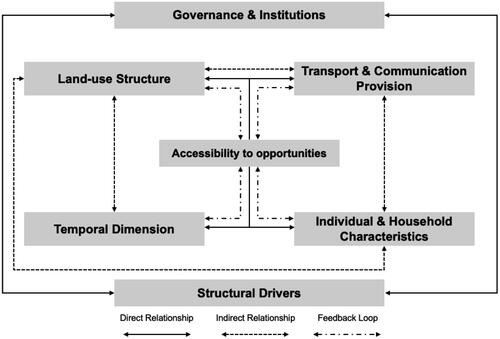
Accessibility is materialized at different scales, which leads to differing interpretations of the concept. It ranges from providing facilities for mobility-reduced individuals to use essential services and amenities in the city to broader interpretations related to the design, connectivity of streets, the relationship between infrastructure networks, and the opportunities available in the city. One way to reconcile these different interpretations of accessibility is by recognizing that the scales of accessibility (i.e. macro, meso, and micro accessibility) are interrelated and correspond to various necessities in society, contributing to the collective potential to guarantee access to economic and social development opportunities (Oviedo et al., Citation2022).
The gradual progress in the conceptual understanding of the social consequences of urban accessibility is related to scholarship and policy discourses historically placing more emphasis on transport’s economic and environmental impacts instead of the unequal distribution of its social impacts (Bueno Cadena et al., Citation2016). An examination of the literature in the last four decades shows that the use of accessibility was marked by a transition in academic and policy debates from purely macro accessibility assessments at the city level to a more holistic understanding of the social and health impacts of transport at the neighborhood scale (meso accessibility) and for individuals and social groups with varying degrees of social and transport (dis)advantage (micro accessibility) (Jones & Lucas, Citation2012). Moreover, in more recent transport research and practice, accessibility has also embodied a desirable outcome of urban transport decision-making, giving rise to new public transport and city-wide infrastructure policies, fare schemes, and operational designs that seek to maximize social welfare (macro accessibility) (Cools et al., Citation2016; Jin et al., Citation2019; Kębłowski, Citation2020). Similarly, the concept of accessibility has experienced a geographical shift from its development and use in the Global North to a growing body of research adapting, redefining, and applying its various interpretations to the Global South (Oviedo et al., Citation2020).
2.2. Accessibility in cities across SSA
Literature on accessibility in SSA has focused on rural and peri-urban areas (Dahab & Sakellariou, Citation2020; Porter et al., Citation2020; Varela et al., Citation2019), centering on the idea that mobility and transport are basic needs due to their role in employment and accessing public services, facilities, and markets. A clear example of the influence of transport on access to opportunities—and one of the most recurrent analyses in the international literature—is access to employment (Alam, Citation2009; Hess, Citation2005; Sanchez et al., Citation2004; Zizzamia, Citation2020). Transport is an explanatory factor of great importance in the successful transition from education to employment (Wachs, Citation2010).
Titheridge et al. (Citation2014) argued that there is a three-way dynamic relationship between jobs, housing, and transport where access to employment is framed by: (i) the distance between housing and jobs; (ii) the availability of transport and its costs; and (iii) the availability of disposable income. The combination of such factors enables individuals to access transport, maintain mobility, and retain employment. Wachs (Citation2010) further argued that transport is essential to reducing poverty and its measurable deficits: nutrition, health, education, housing, and job opportunities. While quantitative approaches drive this body of research, several large-scale qualitative studies have been conducted in cities in SSA. Bryceson et al. (Citation2003) studied the mobility and accessibility needs of underprivileged communities through a livelihoods approach in Zimbabwe and Uganda using focus group discussions and key informant interviews. More recently, Andreasen and Møller-Jensen (Citation2017) studied accessibility in five rapidly growing peripheral settlements in Dar es Salaam, Tanzania. Cooke et al. (Citation2022) adopted the capabilities approach to examine the vulnerabilities faced by non-motorized transport users in the capital cities of South Africa, Zambia, and Rwanda.
There is less literature focusing on accessibility in Western Africa in comparison to Southern and Eastern Africa. Acheampong (Citation2019) observed the importance of considering the accessibility function of transport systems vis-à-vis land-use and land value in Ghana. Falchetta et al. (Citation2021) studied the levels of accessibility by examining paratransit in seven African cities, including Freetown. Oviedo et al. (Citation2022) interrogated the Euro-centric conceptualisations of accessibility to unpack the lived experiences and perceptions of transport (dis)advantage, and their implications on future sustainable mobility transitions in the region.
3. Conceptual framework
The following section introduces the conceptual framework. It examines the notion of sustainable urban transitions for cities across SSA by linking accessibility with sustainability and, consequently, the significance of accelerating the transition to a sustainable accessibility trajectory in the context of Freetown.
3.1. Sustainable urban transitions
This paper explores accessibility and mobility issues in the context of sustainable urban transitions. Here, transitions can be understood as a process of gradual (re)configuration from one dominant socio-technological regime to anotherFootnote1 (Banister, Citation2008; Cavoli et al., Citation2021; Geels, Citation2012).
The concept of sustainable urban transitions is particularly relevant in rapidly growing cities in the Global South with low-but-rising levels of motorization. Cities such as Freetown appear to be at a turning point in their urban development trajectory (Teoh et al., Citation2020)—the combination of several factors, including gross domestic product (GDP) per capita and urban population growth, imports of cheap secondhand cars, lack of adequate public transport, and active travel facilities (in parallel with investments in urban road infrastructure) are leading to an increase in car use levels and investments toward car-oriented urban infrastructure (Cavoli, Citation2021; Pojani & Stead, Citation2017). This is further exacerbated by the lack of integration between transport and land-use planning, increasing urban sprawl (Cervero, Citation2013), as well as a critical lack of emphasis on active transport and accessibility-centric policies (UNEP, Citation2016).
At the same time, the relatively low levels of car use (it is often below 20%) meant that collective and public transport, and in particular, walking, remain the backbone of current mobility systems (Koroma et al., Citation2021). The policy choices that public authorities make will partially determine the city’s development trajectory (international development agencies and supranational structural forces also influence the city’s trajectory) and whether it is aligned with sustainability targets such as the 2015 United Nations Sustainable Development Goals or the 2021 Glasgow Climate Pack. Growing cities in SSA have an opportunity to establish innovative solutions for achieving sustainable and inclusive mobility and land-use patterns and avoid being ‘locked-in’ to a car-dependent development trajectory, which can prove very difficult and expensive to rectify (Jones et al., Citation2018).
3.2. Sustainable accessibility
Building on such a framework, this paper questions how the construction and experience of accessibility and mobility influence urban residents’ attitudes toward car adoption, sustainable mobility, and their interpretations of current policy priorities. The transition to sustainable mobility in cities like Freetown can be examined through a framework that explores different development scenarios linked with motorization and accessibility practices. Simplified analytical approaches (see quadrants in ) represent alternative trajectories with different levels of accessibility a city can follow, using dependency from private motorization as a proxy for how sustainable each potential stage is. The framework is consistent with Teoh et al. (Citation2020) findings which suggested that with GDP per capita growth, there is higher adoption of private car use.
Figure 2. Accessibility levels and private motorized transport use under various urban mobility transition scenarios.
Source: Authors
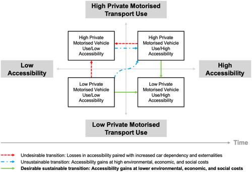
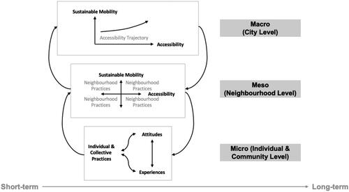
The quadrants in also help frame the potential transitions that can materialize over time at the city and neighborhood levels. further unpacks the evolution of accessibility at the city (macro), neighborhood (meso), and individual and collective (micro) scales, adding a more precise definition of the temporal scale. As shown in , at the first scale and from the short to the long term, cities define their accessibility trajectory, which leads to an evolution in accessibility with more or less sustainable mobility (or, in other terms, lack of dependency from private motorized travel). At the second scale and in the short to medium term, neighborhood practices can lead to more or less accessibility with variable levels of sustainable mobility use. At the most disaggregated scale of the individual and collective, considers the more immediate experiences and attitudes that derive from the accessibility practices people engage with. The framework in posits that all scales of accessibility are interrelated and that the changes in practices, attitudes, and experiences in the short and medium term by individuals and communities are both influenced by and can influence the accessibility trajectory of the city in the long term and its ability to achieve a more or less sustainable transition. The following section provides an overview of Freetown and a brief description of the neighborhoods that fit the different quadrants in .
Figure 3. Links between accessibility practices, experiences, and attitudes at different spatial and temporal scales.
Source: Author
4. Context
The paper focuses on Freetown, Sierra Leone, as an underexamined example of cities in low- and middle-income countries, which concentrate 77% of the world’s urban population (World Bank, Citation2023), and where rapid economic and demographic change is currently leading to increasingly urbanized and car-dependent spatial, functional, and institutional configurations (Oviedo et al., Citation2022).
Freetown is located in the Western Area Urban District of Sierra Leone. It is one of Africa’s most densely populated cities (Koroma et al., Citation2021), and faces rapid population growth. From 2004 to 2015, the city had an estimated annual growth rate of 4.2% (SSL., Citation2016). Freetown is also surrounded by hills and the ocean, bringing a series of development challenges. There is a lack of essential services and amenities like water, electricity, healthcare, and affordable housing. Consequently, informal settlements are developing across the city in areas particularly susceptible to shocks, including flooding and disease outbreaks (Koroma et al., Citation2021).
The city’s informal economy provides jobs for an estimated 70% of Freetonians (SSL., Citation2017a). The transport sector is the second highest generator of jobs, of which 85% are informal, thus making it one of the most significant contributors to Freetown’s vibrant and diverse informal economy (World Bank, Citation2018). Further, as the center of business and government in Sierra Leone, Freetown contributes 30% of the country’s GDP and attracts many rural migrants annually (ibid.). and summarize key demographic and economic indicators of Freetown as well as how the city compares to other capital cities across SSA.
Table 1. Key demographic and economic indicators in Freetown.
Table 2. Socio-economic indicators of Freetown and other capital cities in SSA with similar population.
The informality of the city’s transport sector is a symptom of the limited institutional capacity for planning and delivery of reliable and affordable public transportation. Freetown has also seen an uncontrolled expansion of private and informal collective transport. Despite this expansion, private vehicles continue to dominate the use of road space in the city. As a result, pedestrian spaces in Freetown (walking is the most dominant mode of transport) are constantly being encroached on by private vehicles (Koroma et al., Citation2021). The low-but-rising rate of motorization, as evidenced by the growing numbers of vehicle registrations and subsequent negative externalities such as the increasing number of traffic collisions, is likely to exasperate the environmental and health risks Freetonians face (ibid.).
However, present-day research and policy documents on transport and mobility in Freetown are limited. This results in not merely a lack of understanding of the structural drivers of transport and land-use trends and practices but also substantial data gaps related to urban planning despite the creation of various government-led and international development institutions-led initiatives to consolidate such data in the last decade. This study, therefore, aims to contribute toward research and practice by examining four neighborhoods in Freetown with different levels of accessibility and motorized transport dependency to test the frameworks illustrated in and , and through interrogating residents’ perceptions of the transport, land-use, as well as social and temporal components of accessibility, this study seeks to gain a comprehensive understanding of individual and collective constructions and experiences of urban transport and its potential implications for the city’s future sustainable accessibility trajectory. The four neighborhoods (see and ) were selected based on available secondary data (Koroma et al., Citation2021; World Bank, Citation2018).
Figure 4. Map of Western Area urban District (which comprises Freetown as well as surrounding towns and landscapes) and location of each neighborhood.
Source: OpenStreetMap & Datawrapper
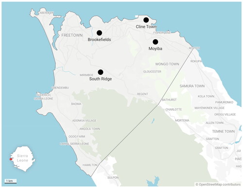
Table 3. Brief description of selected neighborhoods for focus group discussions.
Cline Town
A middle-low-income neighborhood situated along the major trunk road in the east end of Freetown and is linked to the rest of the country by Bureh Road. The area has the largest concentration of warehouses in the municipality, a cement factory, metal workshops, repair garages, and a range of secondary industries. Cline Town thus generates considerable employment opportunities. There are relatively good road networks and port facilities. In addition, Cline Town has a range of schools, health centers, recreational sites, cemeteries, community centers, prominent historical buildings, and a railway museum. The area also experiences heavy traffic load to and from the port area, producing congestion and delays.
Moyiba
A hillside low-income neighborhood (informal settlement) of Freetown with an estimated 37,000 residents (SSL., Citation2017b). The topography makes it difficult to access public transport and emergency services. A vast proportion of the residents access the essential services via footpaths; walking therefore is an affordable and accessible mode of transport (Oviedo et al., Citation2021). Since its establishment in 1919, Moyiba has evolved from a farming community to a major supplier of stones through a quarry in its center (Walker et al., Citation2022). There is a lack of formal land title deeds, with most land informally owned by households or occupied by tenants (ibid.). Furthermore, Moyiba is close to several government offices, contributing to employment opportunities. There is also a range of educational institutions, health centers, and market trading facilities locally known as the Peace Market.
Brookefields
A medium-high income neighborhood close to the city center and well-endowed with infrastructure and services. Brookefields is in a low-lying area and is easily accessible through the many secondary and tertiary roads leading to or servicing it and has a good road network. There is also reasonable access to public transport. The area has public administration, health centers, recreation spaces, religious facilities, cemeteries, and many educational institutions including the Freetown Secondary School for Girls, the Young Women’s Christian Association (YWCA), and other secondary and tertiary training institutions.
Southridge
A mixed neighborhood with different income streams. The hilly topography and a limited coverage infrastructure and collective transport services are significant constraints faced by the local community. Southridge provides low accessibility for its lower-income residents and relatively high motorization amongst its high-income residents. Consequently, the most vulnerable social groups and low-and-middle-income households tend to walk more and often make tradeoffs between walking and okadas (motorcycle taxis) and kekehs (autorickshaws).
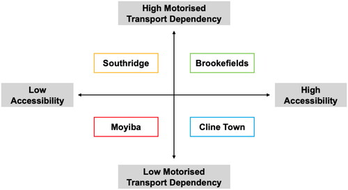
In summary, the selected neighborhoods are socially and economically diverse, and they account for the macro, meso, and micro factors related to the availability of opportunities, local road infrastructure, environmental risks, and difficulties in everyday mobility and access. summarizes the neighborhoods’ observable levels of accessibility and motorized transport dependency.
Figure 5. Location of each neighborhood in the accessibility-motorized transport dependency quadrants.
Source: Authors
5. Data and methods
This paper builds on the analysis of data from focus group discussions to understand how accessibility is perceived at the individual, community, neighborhood, and city levels, as well as the resulting everyday practices, experiences, and attitudes of residents in four neighborhoods across Freetown that are at different stages of motorized transport dependency. In doing so, the paper adds to the substantially limited body of scholarship about the perceptions and attitudes underpinning transport and land-use configurations in cities across SSA, filling a gap in international evidence in a region where most research emerges from South Africa, Kenya, Namibia, and Tanzania while Western Africa continues to be the least studied sub-region (see Sietchiping et al., Citation2012 for overview).
A range of complementary data sources—from open-source and planning data provided by project partners to primary qualitative data—were also used for capturing, to varying degrees, the different scales and factors driving accessibility, enabling the research team to draw relevant policy and planning insights on the quotidian drivers, motivations, and aspirations of residents in urban neighborhoods experiencing diverse social and transport inequalities, so as to determine the factors that might accelerate/decelerate the rising levels of motorization, and consequently, the long-term trajectory the transition toward more sustainable and equitable urban mobility might take.
Qualitative methods (Ferrer & Ruiz, Citation2018; Li, Citation2018; Simons et al., Citation2014) were used in this study so that residents of the four neighborhoods could articulate the deeper nuances of their everyday mobility practices and accessibility in a way that is, as far as possible, free from the preconceived views of the transport researcher, which represented a boundary of what could and/or should be appropriate for discussion. In other words, qualitative methods were used in this study to improve existing understandings and significant data gaps in the characterization of mobility practices and accessibility in Freetown.
Focus group discussion is a common qualitative method to gain an in-depth understanding of transport users’ perceptions, attitudes, and emotions, and they typically consist of between 8 to 15 participants (e.g. Bonham & Wilson, Citation2012; Cascajo et al., Citation2019; Hopkins & Mandic, Citation2017; Hwang et al., Citation2021). Specifically, the focus group discussions conducted in this study aimed to obtain evidence on three areas of accessibility and mobility related to people’s (i) behaviors and practices, (ii) rationales and motivations, and (iii) expectations and suggestions related to policy and practice to “help grasp people’s perspectives, stories, experiences and valuations, as well as the ways these are socio-institutionally structured” in the four neighborhoods selected for this study (van den Broeck, Citation2014, p. 135).
5.1. Data collection and analysis
Each focus group discussion had 12 to 16 participants from the neighborhood to allow for diversity in opinions but also provide the opportunity for everyone to participate (Silverman, Citation2014). In total, 57 individuals participated in these discussions facilitated by three members of the research team. This small group of participants also allowed the team to address some of the challenges that characterize focus group discussions, such as keeping focus, coordinating logistics and ensuring that everyone has the opportunity to participate (ibid.). The participants make-up for the focus group discussions is not representative of the demographic make-up of each neighborhood; owing to the substantial data gaps related to urban planning described in Section 4, this study aims to get an initial but nuanced understanding of everyday livelihood in Freetown that could apply to transport research and beyond. Large-scale quantitative surveys commonly used in transport research are only helpful in the future when researchers and policymakers already have a better grasp of the known knowns and unknown knowns about Freetonians’ everyday mobility practices and accessibility. Facilitators introduced the discussion topics and encouraged participants to share their everyday experiences and perceptions.
In addition, a short survey was carried out with all participants as a pilot for a potential more extensive implementation. This standardized demographic information (e.g. age, gender, length of residence in the neighborhood) and specifics about individual travel behavior (e.g. reasons for traveling out of the neighborhood, mode choice) serve as a backdrop for the in-depth focus group discussions. Participants were provided with a project information sheet and signed a consent form before partaking in the focus group discussions. The consent form described what data participants provided for the study, its intended use, data protection guarantees and the right to withdraw their information.
Overall, women and men were equally representedFootnote2. Each focus group lasted two hours and was conducted in the local Krio language (an English-based creole language), with the discussions recorded (audio), transcribed, and translated by the research team. Participants were asked about the modes of transport used to reach main activities and the frequency of these activities. The age range of participants in Brookefields, Cline Town and South Ridge ranged between 17 to 63 years of age, whereas the focus group discussions participants in Moyiba were considerably younger, aged 21 to 33 years old. Most participants had lived in their neighborhood for over five years.
Analyzing qualitative data is an iterative research process that “involves the examination and re-examination of data” (Silverman, Citation2014, p. 141). This is reflected in the study’s analysis approach, which was carried out in two stages. First, using the accessibility framework developed in Section 3, a thematic content analysis was conducted. This involved an open coding approach that helped identify key themes across the focus group discussions (ibid.). Then, within each theme, the data was organized against the accessibility framework using a focused coding approach.
The analysis matrix is divided into themes and sub-themes. It comprised responses and comments from participants extracted verbatim from the transcripts of the focus group discussions (Miles et al., Citation2019). Then, participant responses are systematically compared through cross-analysis. This exercise allowed the research team to understand the barriers and opportunities to accessibility, travel behavior and private vehicle use. In the second stage, the additional dimension of practices, experiences, and attitudes were added to the analysis matrix. This provided a greater understanding of the on-the-ground realities and some of the assumptions, opinions, and attitudes that are a product of the participants’ lived experiences.
6. Findings
This section provides an overview of the key findings drawing on the analysis of the focus group discussions and surveys undertaken in the four neighborhoods. The key themes are summarized not in any order of importance.
6.1. Urbanization and living peferences (quantity and quality of distribution)
Freetown is the business and commerce center of Sierra Leone, and it attracts people from all over the country, resulting in rapid population growth (Koroma et al., Citation2021). As noted by a participant from Cline Town: “People come from the provinces and other parts of the city to reside here”. As urban-to-urban migrants often cannot access safe and affordable housing in central areas of Freetown, they tend to settle on the hillsides or close to the bay. These areas are considered unsafe due to the increased exposure to natural disasters, notably floods and landslides.
Several participants highlighted how Freetown’s public services are currently unable to meet the increased demand. A participant from Cline Town stated: “There are a lot of disadvantages of rapid population growth with respect to accessing enough facilities and or services”. In Moyiba, participants noted that water is costly due to the neighborhood’s hilly terrain; motorcycles transport water to those living further up the hillside. As a result, accessing water is a challenge for some communities as they rely on motorized transport to access essential services: “We have a big challenge to access water. The [motorcycle] riders charge high because of the nature of the road network in this community”. Although essential services and amenities are available in Brookefields, participants remarked that they tend to be low quality, often requiring travel to other parts of the city to access basic needs.
There was also a growing concern that Freetown’s transport system could not respond to the increased demand. Participants from Clinetown, Brookefields, and Moyiba mentioned that accessing transport services has become more challenging and involves frequent queuing. A participant from Brookefields stated: “There are certain areas that are constantly having traffic due to the increasing population and vehicles”.
6.2. Land-use and accessibility
Residents in Freetown assign significant socio-cultural value to the prospect of owning land, encouraging them to settle in rapidly developing informal settlements. A participant from Moyiba highlighted: “Most of us are here in this community because it is only here that we can have access to land and build our own houses”. Furthermore, when asked about the prospect of relocating within Freetown or moving out of the city, participants from Brookefields and Cline Town noted that they would be open to it if the essential services and amenities would improve in other areas.
“There are some people that don’t want to stay here, especially in the slums. But one will have a lot of constraints in getting stuff like ID cards, passports, and so on if they leave here for a place like Waterloo and beyond because everything is centralised, and that is why people keep coming to the city and settling in the slums.” (Participant from Cline Town)
Beyond the everyday struggles to access basic amenities, the participants find it challenging to access essential services, employment and educational opportunities and recreational activities due to distance and transport povertyFootnote3. In Moyiba, a participant stressed: “We lack so many facilities and services here; no church, no hospital, no school, and no market”. In South Ridge, a participant highlighted: “The lack of financial resources often restricts us from going out to visit friends and families”.
While street traders come to the neighborhoods, the variety of goods they offer is limited and often more expensive than those offered at the centralized markets: “We have markets, but the prices differ from the ones in town. Therefore, most women prefer going to town, especially when they want to buy in bulk. Furthermore, they take up pedestrian space as there are limited markets in these neighborhoods”. Female participants from Moyiba, who do most of the food shopping for their household or business, further noted that they face high transport costs, which “makes them sometimes run into loss”.
6.3. Roads
The limited supply of road and pedestrian infrastructure in Freetown—both in terms of quality and capacity—affects the everyday accessibility of residents across the four neighborhoods studied. Frequently mentioned barriers to accessibility include unsurfaced roads and potholes. A participant from South Ridge noted: “Okadas and kekehs are more expensive in [unpaved] routes”. Along the same vein, a participant from Moyiba observed: “Even when you want to negotiate [with the okada riders] to reduce the cost, they will refuse because of the bad roads and high cost of fuel”. Feeder roads are particularly problematic in Freetown and limit access to more central parts of the city.
The lack of footpaths and safe spaces for pedestrians across Freetown is stressed by a participant in Moyiba: “We don’t have footpaths at all, [putting] our lives to be in danger”. The poor quality and capacity of pedestrian infrastructure often force pedestrians to walk on the road, increasing their risk of being involved in an accident. This is a significant policy and planning challenge, given that the survey finds walking a dominant mode of transport for most Freetonians.
During the rainy season from May to November, transport challenges disproportionally affect the urban poor who live in hilly and flood-prone areas. In Moyiba, participants noted that during the rainy season, there is an increased number of motorcycle accidents: “We usually have a lot of motorcycle accidents during these periods when the roads are muddy and slippery”. Furthermore, travel for older and disabled persons during the rainy season is limited due to the increased cost and limited availability of transport. Residents have established community-driven initiatives to mitigate and respond to some of these issues. For instance, drainages in Moyiba are blocked during the rainy season due to improper waste management and are often cleaned by residents: “We usually mobilize the youths every rainy season to do a cleaning process, especially in the drainages, to allow the easy flow of water and to avoid blockages that will lead to flooding”. However, participants noted a lack of proper planning practices and disaster preparedness or response by the local and national governments.
Beyond the limited supply of road and pedestrian infrastructure across Freetown, the four neighborhoods are affected by the increasing congestion; Moyiba and Cline Town are close to high-demand road corridors and the central business district, while South Ridge faces challenging topographies. A participant from Cline Town summarized: “Why we spend so much time accessing facilities, goods or services from the central parts of the city is because of the traffic”.
6.4. Availability of transport and challenges to travel
6.4.1. Preferred mode of travel
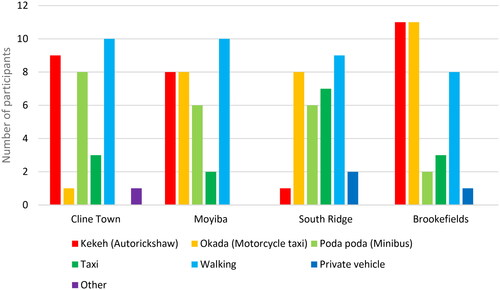
The survey results revealed that the most popular mode of transport varies between each neighborhood studied (), which is in turn influenced by both demography and topography. For example, okadas and kekehs struggle with the hilly dirt roads in Moyiba. Walking is, however, a dominant means of transport across the neighborhoods. As stressed by a participant from South Ridge: “Most time, people spend two to three hours walking to go to town, especially businesspeople”. Due to its central location and good access to public transport, okadas and kekehs are less prevalent in Brookefields.
Figure 6. Mode use per neighborhood.
Source: Authors
While there are some differences related to the availability of transport and the challenges to travel between genders, the data currently collected from the focus group discussions are insufficient to establish a broader perspective on the gendered travel behavior of Freetonians. In South Ridge, female market vendors leave their homes in the night/early morning to avoid traffic issues when buying goods. A male participant emphasizes this: “My wife leaves here at 2 am every morning to go to town to buy [goods]”. However, there is a significant risk of sexual harassment and assault (including rape): “Some [drivers] will pretend to be [motorcycle] riders when they are not. Either they collect something from you, or they rape you, for as long as people are not around”. Traveling together in groups or pairs is a way participants have adopted to mitigate the risk: “Well, sometimes if you are going out alone, then you must take the risk. And you will onboard the same motorcycle with someone if you go out together”.
6.4.2. Affordability
The cost of motorized transport leads to immobility or Freetonians being forced to walk in various neighborhoods. As stated by a participant from South Ridge: “We prefer saving the little we have just for feeding because things are hard these days. [The] biggest inhibitor is the lack of money for transport”. In addition, the transport cost fluctuates depending on the load, quality of roads, weather, and time of day: “It all depends on the distance you are going. You pay double during the rains”.
6.4.3. Safety and security
Participants across the four neighborhoods noted that safety and security issues in Freetown are caused mainly by the city’s limited road and pedestrian infrastructure, inadequate street lighting, lack of traffic enforcement, and challenging travel conditions during the rainy season. As emphasized by a participant from Moyiba: “We don’t use bicycles because the roads are bad, narrow, and congested [making it unsafe to cycle]”. The poor road conditions make accessing parts of the neighborhood difficult without okadas. Furthermore, footpaths across Freetown are often used for parking or street trading, forcing pedestrians onto the roads while causing traffic congestion: “People will just park their cars on the streets, taking part of the streets and causing the roads to be narrower”. Weak traffic enforcement is recognized as a key driver of the day-to-day transport challenges experienced in Freetown: “The level of bribing that we have in Sierra Leone cannot allow the strong enforcement of laws”.
The crime risk on all is significant when traveling at night on any mode of transport. Women and girls are particularly affected and generally consider public transport unsafe due to the risk of sexual harassment and assault, ultimately limiting their everyday mobility. In South Ridge, a participant stressed that: “Women, disabled, and lactating mothers are the most vulnerable when it comes to transportation issues”.
6.5. Future travel preferences
Participants were asked to discuss future travel preferences. While okadas are a dominant mode of motorized transport in the neighborhoods studied, the convenience they offer suggests a complex tradeoff over affordability, safety, and security concerns. Numerous participants aspire to purchase their own motorcycles. A participant from South Ridge highlighted this: “I [would] prefer buying a motorcycle because it is faster”. In Brookefields and Moyiba, several participants mentioned that car use would improve their everyday mobility while acknowledging that the poor road infrastructure and associated costs make car use impractical.
Participants from Moyiba, Cline Town, and Brookefields expressed their desire to have access to high-capacity public transport and stressed their willingness to pay more to access these services. There was also a discussion on the use of electronic ticketing. As stated by a participant from Moyiba: “Yes, we will pay, for as long as the road is good, and the buses are comfortable and safer”. The diversification of transport modes in Freetown, including trains and ferries, was welcomed by participants from Brookefields: “Using trains will be easier and will reduce the intensity of traffic in the city.”
7. Discussion
Findings from this study illustrate the determinants of everyday accessibility and mobility from the perspective of residents’ experiences, practices, and attitudes in four different neighborhoods in Freetown. The conceptual framework introduced in Section 3 allowed the research team to unpack the different geographical scales, time frames, and relationships between land-use and transport development, as well as the residents’ behavior and perceptions of different conditions of dependency on motorized transport, their influence on the potential adoption of motorized transport.
7.1. Everyday experiences of accessibility
The lived, everyday experiences of accessibility can be framed by the quadrants in and the meso scale of the framework presented in . This study identified how community-driven initiatives have emerged to reconfigure the accessibility environment. In neighborhoods like Moyiba and South Ridge, such practices have led to patching up incomplete or damaged infrastructure networks and trying to mitigate environmental risks to local mobility. Community-based practices to restructure the local built environment have recently drawn attention from scholars writing about Africa, which is in line with some of the findings in this paper (Khayesi et al., Citation2016; Lesala Khethisa et al., Citation2020; Oviedo et al., Citation2021). An additional form of community-based practice that reconfigures accessibility across the four neighborhoods is informal trade. It is a source of livelihood for some focus group discussion participants and enables local access to essential goods and services. While the informal economy shapes the everyday accessibility of Freetonians, particularly those living in areas with low levels of accessibility, conventional analyses often dismiss its effects as either fixed in time or space.
Participants’ testimonies suggest that their experiences of accessibility are not just spatially differentiated. They are constantly changing due to the dynamic risks associated with the participant’s everyday environment, the weather, and the ever-changing configuration of the city’s formal and informal public transport network. This supports the need for considering timeframes when approaching accessibility in its different scales.
The analyses of individual experiences of accessibility show that except for Brookefields (the wealthiest neighborhood in the study), walking remains the most common form of transport, followed by the more nimble but expensive okadas and kekehs. As suggested by existing literature, the high dependency on walking can be explained by affordability and poor road infrastructure that cannot support the operation of motorized transport—particularly in some parts of the neighborhoods studied, which are challenged by topography and peripherality (Bryceson et al., Citation2003; Cervero, Citation2013; Kamalipour & Dovey, Citation2019; Oviedo et al., Citation2021), and the need for securing livelihoods, even at the expense of long walking times and risks of injury and crime (Esson et al., Citation2016; Pojani & Stead, Citation2017; Venter et al., Citation2014). Results in Section 6.4 also suggest that in neighborhoods where residents have been both partially excluded from transport supply and priced out of transport, gaps in mobility, accessibility, and expenditure on transport (in terms of time, money, and effort) are more marked, leading to higher levels of immobility in some population groups.
The gender dimension becomes particularly relevant in discussions about the experiences of accessibility and their influence on residents’ attitudes toward adopting motorized transport. Women in all neighborhoods negotiate additional risks and costs for accessing essential goods and services. The information on mode choice suggests that when purchasing power is available, women tend to spend more on motorized transport, especially for trips conducted when risks are higher (e.g. nighttime and rainy season). Women’s experiences, practices, and attitudes must be explicitly recognized in transport policy and practice, particularly in planning and regulating collective transport services. A more explicit gender dimension must be incorporated into Freetown’s future public transport reforms. The latter may become instrumental in preventing a transition to car-dependent urban development as the city’s purchasing power increases.
7.2. Freetown’s sustainable accessibility trajectory
In Sub-Saharan African cities, issues at the macro scale have almost invariably been addressed through a top-down approach in the accessibility literature and practice (Bautista-Hernández, Citation2020; Klopp & Cavoli, Citation2017; Levine, Citation2020). These issues are also approached from a quantitative perspective (Malekzadeh & Chung, Citation2020; van Wee, Citation2016). The actual decision-making processes concerning the macro or strategic accessibility are, therefore, somewhat disconnected from the everyday, lived experiences of accessibility which affects marginalized and vulnerable Freetonians the most as the city develops (Oviedo & Nieto-Combariza, Citation2021; Uteng & Lucas, Citation2017; Venter et al., Citation2019). The focus group discussions challenge mainstream decision-making approaches, demonstrating that most participants’ rudimentary understanding of how long-term city-wide urbanization and development processes (Section 6.1), as well as transport and land-use planning (Section 6.2), influence their everyday ability to use diverse forms of transport and gain access to livelihood opportunities. These findings align with previous research unpacking the city’s development from different perspectives (Koroma et al., Citation2021; Oviedo et al., Citation2021; World Bank, Citation2018). Furthermore, despite the significant differences in each neighborhood’s social, economic, spatial, and motorized dependency features, results related to the macro scale suggest that needs-based informal practices related to land-use, housing, and transport are significant drivers of accessibility and influence people’s decisions and attitudes toward the future, particularly concerning the adoption of high-capacity motorized transport.
7.3. Learnings for transitions to sustainable accessibility
Findings from the focus group discussions shed light on the links between the individual and collective construction of everyday accessibility and people’s attitudes toward (un)sustainable mobility, particularly the adoption of private vehicle use. On the one hand, the perceptions from neighborhoods with poor accessibility (i.e. Moyiba and Cline Town) are that even if income increased, the poor quality and quantity of roads would be a sufficient deterrent to prevent participants from purchasing a car. On the other hand, in wealthier and more accessible neighborhoods (i.e. Brookefields and South Ridge), car and especially motorcycle ownership are perceived as potential means of improving one’s everyday mobility and access after factoring in the challenges associated with accessing affordable, reliable, and safe public transport, long walking duration, road congestion, as well as the host of environmental and personal security risks involved. While there are several lessons Freetown can offer other cities in SSA with low-but-rising levels of motorization, particularly the massive role played by informal transport as well as the lack of policy priority given to non-motorized transport, it is hard to draw generalizable learnings from the perceptions about the adoption of private motorization by a study of this scale as a multitude of structural and socio-cultural forces compounds the issue.
Participants’ contrasting attitudes toward adopting private motorized vehicles are further complicated by local geographical constraints. In South Ridge and Moyiba, where there is a more challenging topography, the motorcycle is seen as a feasible alternative to improve mobility regardless of income level. Such findings caution planners and policymakers in Freetown and other fast-growing sub-Saharan African cities about the rise in the modal share of private motorized vehicles that often accompanies GDP per capita growth and the challenge it poses for transitioning to sustainable mobility if no planning and policy reforms are made to improve access to non-motorized and public transport.
8. Conclusions
This study highlights the relevance and usefulness of sustainable accessibility frameworks in analyzing everyday practices for mobility and interrogating the drivers of future sustainable development pathways. The paper’s main conclusion is that inaccessibility leads to double marginalization. In other words, exclusion from essential and good-quality opportunities for those neighborhoods in a more disadvantaged accessibility position was found to be compounded by vulnerability and exposure to environmental risks and externalities. The analysis of everyday accessibility provides a solid and deep foundation to inform large-scale assessments of distributional and equity issues informed by more traditional data collection methods, such as surveys, which can further inform the targeting of policies and optimization of resources. We found that perceived accessibility influences everyday mobility and land-use practices and the attitudes of individuals in diverse communities toward sustainable mobility by driving them to trade off immediate needs with long-term risks and exposures, imagine motorized futures, and collectively transform the functional and physical configuration of their built environment to address their most critical needs in the absence of suitable top-down interventions.
The unheard voices of Freetonians taking part in this study made it evident that there can be no positive change without participation, as testimonies from citizens with different intersecting social identities can debunk deep-seated assumptions such as a default turn toward specific modes without considering the local socio-cultural contexts. The complexities of cities in SSA, coupled with the considerable gaps in empirical evidence in these contexts despite the scale and relevance of their urban development trajectories for global sustainability, support the need for localized methods that unpack the nuances and challenge the biases of traditional transport research methods. This leads to the conclusion that research must play a role in enabling dialogues between citizens, academia, practitioners, and policymakers and, therefore, building new bridges previously not considered in the collective construction of sustainable mobility.
The diversity of motivations and attitudes toward mode choice, including the paradoxes in current and future needs, demonstrates the limitations of conventional transport planning instruments and research methods where everyday mobility practices and experiences are over-simplified and biased toward realized travel, ignoring the travel needs of underserved and marginalized populations. For example, it is essential to recognize that most participants walk and, consequently, that integrating non-motorized travel into Freetown’s transport policies has strategic significance for achieving sustainable accessibility. The lack of targeted policies and investments that address the city’s poor pedestrian infrastructure highlights the gap between policy and planning and the everyday, lived experiences of Freetonians. There is also a lack of mention of cycling-related infrastructure by participants. The city’s challenging topographies and weather conditions obscure whatever potential the city may have to accommodate cycling as a viable mode of transport. Existing and often negative perceptions about cycling are unlikely to change without an initial adoption of pro-cycling policies to shift the public’s attitudes and perceptions.
The motorized future articulated by a sizeable portion of participants represents the socio-institutional challenges faced by Freetown and other fast-growing cities across SSA, which are at a similar point in their motorization process and are seeking to transition toward sustainable mobility with high levels of accessibility for all. It also opens questions concerning the methodological learnings that future research on the subject matter may consider to better understand individuals’ everyday mobility practices and accessibility experiences vis-à-vis their social identities. In addition to the transport policies mentioned above, improving access to suitable goods, services, and livelihood opportunities, mainly through policies and investments targeted at enhancing internet connectivity and other online services, can be critical in reducing trips and distances traveled across the city.
8.1. Research limitations
Our research highlights the relevance of qualitative insights for understanding the lived experiences of accessibility and the interrelations between urban trajectories, practices, perceptions, and attitudes of residents. However, the sample size of this study is a limitation for drawing generalizable insights that are representative of the demographics of the neighborhoods surveyed. It is, therefore, necessary to expand the diversity of participants in future research to account for the everyday experiences of individuals with intersecting social identities, including ethnic minorities, people with disabilities and different gender and sexual identities.
However, the evidence gathered from the everyday practices of participants illustrates the value of qualitative methods beyond deep-seated requirements for representativeness usually adopted in disciplines linked with transport and land-use planning. Methods from the social sciences and humanities add layers of complexity to make visible the wide-ranging environmental and socio-economic consequences of urban development trajectories. The perspectives of residents about their everyday mobility practices and environment for accessibility presented in Section 7 are very rarely heard in traditional transport policy and planning, effectively ignoring those most affected by public policy and transport planning practices. This also means considering the potential contradictions between different testimonies and extracting their contextual significance, as they are an inherent part of people’s daily experiences and tradeoffs to secure their livelihoods.
8.2. Avenues for further research
The research opens new conceptual and methodological avenues for accessibility analysis that can be scaled up in cities across SSA. Specifically, the qualitative research approach described in this paper illustrates a practical foundation for decolonized transport research that is aligned with the global development agenda, national and local policy and planning priorities whilst also giving space to the voices of residents, which are rarely heard in conventional, mainstream transport research in such depth and detail. As argued in the previous paragraphs, further research is necessary to test the frameworks and instruments in other urban contexts across different intersecting social identities. There is also potential to build on qualitative insights to inform the design of quantitative instruments that can capture urban residents’ mobility practices, experiences, and attitudes at a broader scale. Similarly, there is potential to expand the content of focus groups to understand differing needs and desires concerning public and collective transport, its improvement in the local context, and its role as a people-centric instrument to accelerate sustainable mobility transitions.
Ethical approval
This research received ethical approval from the University College London Research Ethics Board under project ID 8699/002. We confirm that all participants in this research were provided with appropriate informed consent forms, as explained in the methods section.
Acknowledgements
The team thanks Professor Peter Jones, Professor Caren Levy from University College London and Dr Joseph Mustafa McCarthy from the Sierra Leone Urban Research Centre for their input and advice. We also thank the Federation of the Urban Poor in Sierra Leone for their help in facilitating access to the communities and participants. We also acknowledge the contributions of Miss Sudie Austina Sellu from the Sierra Leone Urban Research Centre for her support. Finally, we thank all the participants and residents of urban communities in Freetown who informed and facilitated this research.
Disclosure statement
No potential conflict of interest was reported by the author(s).
Additional information
Funding
Notes
1 For example, societies transitioned from horse-drawn carriages to the automobile in the twentieth century (Kemp et al., Citation2012).
2 At Moyiba, two-thirds of the focus group discussion participants were women.
3 The term ‘transport poverty’ is used in literature to describe various deprivations related to transport access and affordability (Churchill & Smyth, Citation2019). It is used in this study in a narrower sense to refer to individuals and households finding it difficult to meet the monetary costs associated with transport.
References
- Acheampong, R. A. (2019). Integrated spatial development and transportation planning. In Spatial planning in Ghana: Origins, contemporary reforms and practices, and new perspectives (pp. 231–268). Springer.
- AfDB (2021). African economic Outlook 2021.
- Agora Verkehrswende, & GIZ. (2023). Leapfrogging to Sustainable Transport in Africa: Twelve Insights into the Continent’s Sector Transformation. Retrieved Mar 12, 2023, from https://www.agora-verkehrswende.de/en/publications/leapfrogging-to-sustainable-transport-in-africa-twelve-insights/
- Alam, B. M. (2009). Transit accessibility to jobs and employment prospects of welfare recipients without cars: A study of Broward County, Florida, using geographic information systems and an econometric model. Transportation Research Record: Journal of the Transportation Research Board, 2110(1), 78–86. https://doi.org/10.3141/2110-10
- Andreasen, M. H., & Møller-Jensen, L. (2017). Access to the city: Mobility patterns, transport and accessibility in peripheral settlements of Dar es Salaam. Journal of Transport Geography, 62, 20–29. https://doi.org/10.1016/j.jtrangeo.2017.05.005
- Banister, D. (2008). The sustainable mobility paradigm. Transport Policy, 15(2), 73–80. https://doi.org/10.1016/j.tranpol.2007.10.005
- Bautista-Hernández, D. A. (2020). Commuting inequality, role of urban structure, and identification of disadvantaged groups in the Mexico City metropolitan area. Journal of Transport and Land Use, 13(1), 159–183. https://doi.org/10.2307/26967240
- Benton, J. S., Jennings, G., Walker, J., & Evans, J. (2023). “Walking is our asset”: How to retain walking as a valued mode of transport in African cities. Cities, 137. https://doi.org/10.1016/j.cities.2023.104297
- Bonham, J., & Wilson, A. (2012). Bicycling and the life course: The start-stop-start experiences of women cycling. International Journal of Sustainable Transportation, 6(4), 195–213. https://doi.org/10.1080/15568318.2011.585219
- Bryceson, D. F., Mbara, T. C., & Maunder, D. (2003). Livelihoods, daily mobility and poverty in sub-Saharan Africa. Transport Reviews, 23(2), 177–196. https://doi.org/10.1080/01441640309891
- Bueno Cadena, P. C., Vassallo, J. M., Herraiz, I., & Loro, M. (2016). Social and distributional effects of public transport fares and subsidy policies: Case of Madrid, Spain. Transportation Research Record: Journal of the Transportation Research Board, 2544(1), 47–54. https://doi.org/10.3141/2544-06
- Cascajo, R., Lopez, E., Herrero, F., & Monzon, A. (2019). User perception of transfers in multimodal urban trips: A qualitative study. International Journal of Sustainable Transportation, 13(6), 393–406. https://doi.org/10.1080/15568318.2018.1476632
- Cavoli, C. (2021). Accelerating sustainable mobility and land-use transitions in rapidly growing cities: Identifying common patterns and enabling factors. Journal of Transport Geography, 94, 103093. https://doi.org/10.1016/j.jtrangeo.2021.103093
- Cavoli, C., Yusuf, Y., Oviedo, D., Mella Lira, B., Koroma, B., & Jones, P. (2021). Transitions to sustainable urban mobility: Participatory policy planning.
- Cervero, R. (2013). Linking urban transport and land use in developing countries. Journal of Transport and Land Use, 6(1), 7–24. https://doi.org/10.5198/jtlu.v6i1.425
- Churchill, S. A., & Smyth, R. (2019). Transport poverty and subjective wellbeing. Transportation Research Part A: Policy and Practice, 124, 40–54. https://doi.org/10.1016/j.tra.2019.03.004
- Cooke, S., Ryseck, B., Siame, G., Nkurunziza, A., Molefe, L., & Zuidgeest, M. (2022). Proximity is not access: A capabilities approach to understanding non-motorized transport vulnerability in African cities. Frontiers in Sustainable Cities, 4, 1–13 . https://doi.org/10.3389/frsc.2022.811049
- Cools, M., Fabbro, Y., & Bellemans, T. (2016). Free public transport: A socio-cognitive analysis. Transportation Research Part A: Policy and Practice, 86, 96–107. https://doi.org/10.1016/j.tra.2016.02.010
- Dahab, R., & Sakellariou, D. (2020). Barriers to accessing maternal care in low income countries in Africa: A systematic review. International Journal of Environmental Research and Public Health, 17 (12), 4292. https://doi.org/10.3390/ijerph17124292
- Esson, J., Gough, K. V., Simon, D., Amankwaa, E. F., Ninot, O., & Yankson, P. W. K. (2016). Livelihoods in motion: Linking transport, mobility and income-generating activities. Journal of Transport Geography, 55, 182–188. https://doi.org/10.1016/j.jtrangeo.2016.06.020
- Falchetta, G., Noussan, M., & Hammad, A. T. (2021). Comparing paratransit in seven major African cities: An accessibility and network analysis. Journal of Transport Geography, 94, 103131. https://doi.org/10.1016/j.jtrangeo.2021.103131
- Ferrer, S., & Ruiz, T. (2018). The impact of the built environment on the decision to walk for short trips: Evidence from two Spanish cities. Transport Policy, 67, 111–120. https://doi.org/10.1016/j.tranpol.2017.04.009
- Geels, F. W. (2012). A socio-technical analysis of low-carbon transitions: Introducing the multi-level perspective into transport studies. Journal of Transport Geography, 24, 471–482. https://doi.org/10.1016/j.jtrangeo.2012.01.021
- Gössling, S., Schröder, M., Späth, P., & Freytag, T. (2016). Urban space distribution and sustainable transport. Transport Reviews, 36(5), 659–679. https://doi.org/10.1080/01441647.2016.1147101
- Hansen, W. G. (1959). How accessibility shapes land use. Journal of the American Institute of Planners, 25(2), 73–76. https://doi.org/10.1080/01944365908978307
- Hess, D. B. (2005). Access to employment for adults in poverty in the Buffalo-Niagara region. Urban Studies, 42(7), 1177–1200. https://doi.org/10.1080/00420980500121384
- Hopkins, D., & Mandic, S. (2017). Perceptions of cycling among high school students and their parents. International Journal of Sustainable Transportation, 11(5), 342–356. https://doi.org/10.1080/15568318.2016.1253803
- Hwang, J., Li, W., Stough, L. M., Lee, C., & Turnbull, K. (2021). People with disabilities’ perceptions of autonomous vehicles as a viable transportation option to improve mobility: An exploratory study using mixed methods. International Journal of Sustainable Transportation, 15(12), 924–942. https://doi.org/10.1080/15568318.2020.1833115
- Jin, Z., Schmöcker, J. D., & Maadi, S. (2019). On the interaction between public transport demand, service quality and fare for social welfare optimisation. Research in Transportation Economics, 76, 100732. https://doi.org/10.1016/j.retrec.2019.05.005
- Johansen, N., Wilson, R., Tichon, J., Senserrick, T., & Tranter, K. (2021). Decolonizing road safety for transportation justice in Australia. Transportation Research Part D: Transport and Environment, 98, 102970. https://doi.org/10.1016/j.trd.2021.102970
- Jones, P. (2014). The evolution of urban mobility: The interplay of academic and policy perspectives. IATSS Research, 38(1), 7–13. https://doi.org/10.1016/j.iatssr.2014.06.001
- Jones, P., & Lucas, K. (2012). The social consequences of transport decision-making: Clarifying concepts, synthesising knowledge and assessing implications. Journal of Transport Geography, 21, 4–16. https://doi.org/10.1016/j.jtrangeo.2012.01.012
- Jones, P., Anciaes, P., Buckingham, C., Cavoli, C., Cohen, T., Cristea, L., Gerike, R., Halpern, C., Pickup, L. (2018). Urban mobility: Preparing for the future, learning from the past - CREATE project summary and recommendations. https://discovery.ucl.ac.uk/id/eprint/10058850/
- Kamalipour, H., & Dovey, K. (2019). Mapping the visibility of informal settlements. Habitat International, 85, 63–75. https://doi.org/10.1016/j.habitatint.2019.01.002
- Kębłowski, W. (2020). Why (not) abolish fares? Exploring the global geography of fare-free public transport. Transportation, 47(6), 2807–2835. https://doi.org/10.1007/s11116-019-09986-6
- Kemp, R., Geels, F. W., & Dudley, G. (2012). Introduction: Sustainability transitions in the automobility and the need for a new perspective. In F. W. Geels, R. Kemp, G. Dudley, & G. Lyons (Eds.), Automobility in transition?: A socio-technical analysis of sustainable transport (pp. 3–28). Routledge.
- Khayesi, M., Nafukho, F. M., & Kemuma, J. (2016). Informal public transport in practice: Matatu Entrepreneurship. In Informal public transport in practice: matatu entrepreneurship. Taylor and Francis. https://doi.org/10.4324/9781315588490
- Klopp, J. M., & Cavoli, C. M. (2017). The paratransit puzzle: Mapping and master planning for transportation in Maputo and Nairobi. In T. P. Uteng, & K. Lucas (Eds.), Urban mobilities in the global south (pp. 95–110). Routledge.
- Koroma, B., Oviedo, D., Yusuf, Y., Macarthy, J. M., Cavoli, C., Jones, P. M., Levy, C., & Sellu, S. A. (2021). City profile: Freetown, base conditions of mobility, accessibility and land use. London, UK: University College London.
- Lesala Khethisa, B., Tsibolane, P., & Van Belle, J. P. (2020). Surviving the Gig economy in the global south: How Cape Town domestic workers cope. IFIP Advances in Information and Communication Technology, 601, 67–85. https://doi.org/10.1007/978-3-030-64697-4_7
- Levine, J. (2020). A century of evolution of the accessibility concept. Transportation Research Part D: Transport and Environment, 83, 102309. https://doi.org/10.1016/j.trd.2020.102309
- Levy, C., Allen, A., Castán Broto, V., & Westman, L. (2017). Unlocking urban trajectories: Planning for environmentally just transitions in Asia. In F. Caprotti, & L. Yu (Eds.), Sustainable cities in Asia (pp. 7–22). Routledge.
- Li, J. (2018). Residential and transit decisions: Insights from focus groups of neighborhoods around transit stations. Transport Policy, 63, 1–9. https://doi.org/10.1016/j.tranpol.2017.10.012
- Malekzadeh, A., & Chung, E. (2020). A review of transit accessibility models: Challenges in developing transit accessibility models. International Journal of Sustainable Transportation, 14(10), 733–748. https://doi.org/10.1080/15568318.2019.1625087
- Miles, M. B., Huberman, A. M., & Saldaña, J. (2019). Qualitative data analysis: A methods sourcebook (4th ed.).
- ODI. (2020). City profile: Freetown, Sierra Leone. https://cdn.odi.org/media/documents/hmi_mayors_dialogue_freetown.pdf
- Oviedo, D., Villamizar Duarte, N., & Ardila Pinto, A. M. (Eds.) (2020). Urban mobility and social equity in Latin America: Evidence, concepts, methods. Emerald Publishing.
- Oviedo, D., Cavoli, C., Jones, P., Levy, C., Koroma, B., Macarthy, J. M., Sabogal, O., & Arroyo, F. (2022). Accessibility and sustainable mobility transitions in Sub-Saharan Africa: Insights from Freetown. Journal of Transport Geography, 105, 103464. https://doi.org/10.1016/j.jtrangeo.2022.103464
- Oviedo, D., & Guzmán, L. Á. (2020). Should urban transport become a social policy? Interrogating the role of accessibility in social equity and urban development in Bogotá, Colombia. In D. Oviedo, N. Villamizar Duarte, & A. M. Ardila Pinto (Eds.), Urban mobility and social equity in Latin America: Evidence, concepts, methods (pp. 11–32). Emerald Publishing.
- Oviedo, D., & Nieto-Combariza, M. (2021). Transport planning in the global south. International Encyclopedia of Transportation. 118–124. https://doi.org/10.1016/B978-0-08-102671-7.10624-4
- Oviedo, D., Okyere, S. A., Nieto, M., Kita, M., Kusi, L. F., Yusuf, Y., & Koroma, B. (2021). Walking off the beaten path: Everyday walking environment and practices in informal settlements in Freetown. Research in Transportation Business & Management, 40, 100630. https://doi.org/10.1016/j.rtbm.2021.100630
- Peralta-Quiros, T., Kerzhner, T., & Avner, P. (2019). Exploring accessibility to employment opportunities in African cities: A first Benchmark (8971).
- Pojani, D., & Stead, D. (Eds.) (2017). The urban transport crisis in emerging economies. Springer.
- Porter, G., Abane, A., & Lucas, K. (2020). User diversity and mobility practices in sub-Saharan African cities: Understanding the needs of vulnerable populations. The State of Knowledge and Research.
- Sanchez, T. W., Shen, Q., & Peng, Z. R. (2004). Transit mobility, jobs access and low-income labour participation in us metropolitan areas. Urban Studies, 41(7), 1313–1331. https://doi.org/10.1080/0042098042000214815
- Schwanen, T. (2018). Towards decolonised knowledge about transport. Palgrave Communications, 4(1), 1–6. https://doi.org/10.1057/s41599-018-0130-8
- Schwanen, T. (2020). Towards decolonial human subjects in research on transport. Journal of Transport Geography, 88, 102849. https://doi.org/10.1016/j.jtrangeo.2020.102849
- Sietchiping, R., Permezel, M. J., & Ngomsi, C. (2012). Transport and mobility in sub-Saharan African cities: An overview of practices, lessons and options for improvements. Cities, 29(3), 183–189. https://doi.org/10.1016/j.cities.2011.11.005
- Silverman, R. M. (2014). Analysing qualitative data. In E. A. Silva, P. Healey, N. Harris, & P. van den Broeck (Eds.), The Routledge handbook of planning research methods (pp. 140–156). Routledge. https://doi.org/10.4324/9781315851884.ch3.2
- Simons, D., Clarys, P., de Bourdeaudhuij, I., de Geus, B., Vandelanotte, C., & Deforche, B. (2014). Why do young adults choose different transport modes? A focus group study. Transport Policy, 36, 151–159. https://doi.org/10.1016/j.tranpol.2014.08.009
- SSATP. (2020). Policies for Sustainable Accessibility and Mobility in the Cities of Burkina Faso. Retrieved Mar 12, 2023, from https://www.ssatp.org/sites/ssatp/files/publication/1143_190-rap-jal-egu-BF-FinalReport-EN_v2_%28VersionNonMiseEnForme%29.pdf
- SSL, OPHI, & UNEP. (2019). Sierra Leone multidimensional poverty index 2019.
- SSL. (2016). 2015 population and housing census: Summary of final results.
- SSL. (2017a). Sierra Leone 2015 population and housing census: Thematic report on economic characteristics.
- SSL. (2017b). Sierra Leone 2015 population and housing census: Thematic report on population structure and population distribution.
- SSL. (2017c). Sierra Leone 2015 population and housing census: Thematic report on poverty and durables.
- Teoh, R., Anciaes, P., & Jones, P. (2020). Urban mobility transitions through GDP growth: Policy choices facing cities in developing countries. Journal of Transport Geography, 88, 102832. https://doi.org/10.1016/j.jtrangeo.2020.102832
- Titheridge, H., Christie, N., Mackett, R., Oviedo Hernández, D., & Ye, R. (2014). Transport and poverty: A review of the evidence.
- UNDP. (2022). Human development index (HDI). https://hdr.undp.org/data-center/human-development-index#/indicies/HDI
- UNEP. (2016). Global Outlook on walking and cycling: policies & realities from around the world.
- UNEP, & UN-Habitat. (2022). Walking and Cycling in Africa – Evidence and Good Practice to Inspire Action. Retrieved Apr 15, 2023, from https://wedocs.unep.org/20.500.11822/40071
- UNGA (2015, October 21). Transforming our world: The 2030 agenda for sustainable development. Seventieth Session (Agenda Items 15 and 116). https://www.un.org/en/development/desa/population/migration/generalassembly/docs/globalcompact/A_RES_70_1_E.pdf
- UN-Habitat (2016). New urban agenda.
- Uteng, T. P., & Lucas, K. (2017). The trajectories of urban mobilities in the Global South: An introduction. In T. P. Uteng, & K. Lucas (Eds.), Urban mobilities in the global south (pp. 1–18). Routledge.
- van den Broeck, P. (2014). Rediscovering qualitative research. In E. A. Silva, P. Healey, N. Harris, & P. van den Broeck (Eds.), The Routledge handbook of planning research methods (pp. 135–139). Routledge. https://doi.org/10.4324/9781315851884.ch3.1
- van Wee, B. (2016). Accessible accessibility research challenges. Journal of Transport Geography, 51, 9–16. https://doi.org/10.1016/j.jtrangeo.2015.10.018
- Van Wee, B. V., & Geurs, K. (2011). Discussing equity and social exclusion in accessibility evaluations. European Journal of Transport and Infrastructure Research, 11(4), 350–367. https://doi.org/10.18757/EJTIR.2011.11.4.2940
- Varela, C., Young, S., Mkandawire, N., Groen, R. S., Banza, L., & Viste, A. (2019). Transportation barriers to health care access for surgical conditions in Malawi: A cross sectional nationwide household survey. BMC Public Health, 19(1), 264. https://doi.org/10.1186/s12889-019-6577-8
- Vecchio, G., Tiznado-Aitken, I., & Hurtubia, R. (2020). Transport and equity in Latin America: A critical review of socially oriented accessibility assessments. Transport Reviews, 40(3), 354–381. https://doi.org/10.1080/01441647.2020.1711828
- Velaga, N. R., Beecroft, M., Nelson, J. D., Corsar, D., & Edwards, P. (2012). Transport poverty meets the digital divide: Accessibility and connectivity in rural communities. Journal of Transport Geography, 21, 102–112. https://doi.org/10.1016/j.jtrangeo.2011.12.005
- Venter, C., Mahendra, A., & Hidalgo, D. (2019). From mobility to access for all: Expanding urban transportation choices in the global south.
- Venter, C. J., Molomo, M., & Mashiri, M. (2014). Supply and pricing strategies of informal rural transport providers. Journal of Transport Geography, 41, 239–248. https://doi.org/10.1016/j.jtrangeo.2014.10.001
- Wachs, M. (2010). Transportation policy, poverty, and sustainability: History and future. Transportation Research Record: Journal of the Transportation Research Board, 2163(1), 5–12. https://doi.org/10.3141/2163-01
- Walker, J., Koroma, B., Sellu, S. A., & Rigon, A. (2022). The social regulation of livelihoods in unplanned settlements in Freetown: Implications for strategies of formalisation. International Development Planning Review, 44(1), 33–54. https://doi.org/10.3828/idpr.2021.3
- Weiss, D. J., Nelson, A., Gibson, H. S., Temperley, W., Peedell, S., Lieber, A., Hancher, M., Poyart, E., Belchior, S., Fullman, N., Mappin, B., Dalrymple, U., Rozier, J., Lucas, T. C. D., Howes, R. E., Tusting, L. S., Kang, S. Y., Cameron, E., Bisanzio, D., … Gething, P. W. (2018). A global map of travel time to cities to assess inequalities in accessibility in 2015. Nature, 553(7688), 333–336. https://doi.org/10.1038/nature25181
- Wood, A., Kębłowski, W., & Tuvikene, T. (2020). Decolonial approaches to urban transport geographies: Introduction to the special issue. Journal of Transport Geography, 88, 102811. https://doi.org/10.1016/j.jtrangeo.2020.102811
- World Bank (2018). Reviving urban development: The importance of freetown for the national development. https://openknowledge.worldbank.org/handle/10986/30032
- World Bank (2023). Urban population – World, low & middle income. https://data.worldbank.org/indicator/SP.URB.TOTL?locations=1W-XO
- Wu, H., & Levinson, D. (2020). Unifying access. Transportation Research Part D: Transport and Environment, 83, 102355. https://doi.org/10.1016/j.trd.2020.102355
- Zizzamia, R. (2020). Is employment a panacea for poverty? A mixed-methods investigation of employment decisions in South Africa. World Development, 130(104938), 104938. https://doi.org/10.1016/j.worlddev.2020.104938