
ABSTRACT
Relationships between humans and environments are deeply challenged by recognition of the Anthropocene, which implicates humans as major drivers of planetary-scale environmental changes. Responding to these challenges requires technical expertise, but also creativity in dealing with complex social, cultural and political relationships of place. This paper introduces Relief as an art project that repurposes historical aerial photographs for the creation of affective, low-tech 3D experiences of landscapes and their histories. The creation of these works, and the experience of viewing them, offer a process for witnessing change in the Anthropocene. Content and aesthetics bring viewers into different ways of seeing landscapes, with implications for outreach and communication, as well as approaches to situating science and scientist in relation to society, politics and place. This art project leads into discussion of human agents and non-human agents as co-producers of landscapes, and the opportunities for art and science to respond to environmental concerns.
1. Introduction
Recognition of the Anthropocene brings deep challenges to human-environment relationships and our place in the world by asserting that our re-shaping of the planet's surface is a force of geological scale (CitationCrutzen, 2002; CitationMaslin & Lewis, 2015; CitationSteffen, Crutzen, & McNeill, 2007). Activities such as mining, dam building, manufacturing and urban development have altered geologic, geomorphic, hydrologic and atmospheric systems and processes in significant ways, unsettling our relationships with natural systems. This upheaval of our sense of place in the world has been likened to the destabilising effect brought by the discovery of plate tectonics (CitationClark, 2011) and even Galileo's radical insistence that the Earth does indeed move (and now is trembling in response to our significant environmental impacts; Serres, quoted in CitationLatour, 2014). So deep are the Anthropocene's challenges to society and a sense of place that writers are developing new vocabulary specifically to describe them (CitationMacfarlane, 2016) and even proposing ‘psychoterratic disorders’ that stem from socio-environmental change (CitationAlbrecht et al., 2007). As a fluvial geomorphologist, it is easy to reach for instances that confirm the Anthropocene, if not necessarily as a formal geological epoch, then as an expression of the deep, complex and compounding ways that humans have changed the surface of the Earth in the ‘critical zone’ (CitationBrown et al., 2017; CitationLewin & Macklin, 2014; CitationMeybeck, 2003; CitationWohl, 2013).
Geomorphology and related geoscientific disciplines are recognising and responding to these complex human-environment relationships by investigating the co-production of social and physical systems (e.g. CitationAshmore, 2015; CitationLinton & Budds, 2014; CitationMould, Fryirs, & Howitt, 2018; CitationUrban, 2002). Recognition of geomorphic landscapes as co-produced by social and physical processes goes further than investigation of ‘human impacts’ (CitationHead, 2008). It suggests that humans are acting with environments from within socio-natural systems, echoing longer-standing arguments from the social sciences and environmental philosophy (e.g. CitationLatour, 2005; CitationMuecke, 2006). Co-production and the Anthropocene are opening up discourse within sciences – including in physical geography – about the roles of science and scientists as social, political and environmental agents who not only investigate landscapes but also re-make landscapes through their positions, intentions, interventions and analytical frameworks (CitationAshmore, 2015; CitationMould et al., 2018; CitationTadaki, Brierley, & Cullum, 2014). A proposed ‘critical physical geography’ (i.e. reflection and critique from within physical geography) aims to explore these concerns (CitationLave et al., 2014; CitationTadaki, Brierley, Dickson, Le Heron, & Salmond, 2015).
My own research interests in fluvial geomorphology relate to river rehabilitation and recovery, and how physical and social processes combine to make and re-make rivers. Stemming from this research is recognition of the politics of being a scientist – and a citizen – embedded in relationships between people and places. Particularly in river rehabilitation, we must engage with others, who see, feel and know differently to ourselves, and yet to a large degree, our scientific training does not prepare us for this challenge. I feel tension between my scientific culture, which values objectivity, and my felt responsibility to engage with the socio-political context of connection in which I live and work. Rather than attempting to suppress this tension, I make use of it through an art practice that allows me to explore both divergence and convergence between my science, my self and my sense of place. This paper will present a selection of images from the art project, Relief, in which historical aerial survey photographs are repurposed to tell stories about geomorphic landscapes and challenging human-environment interactions. This project is innovative in that it transforms aerial photographs from inert snapshots into an impetus for critically exploring time and agency in environmental change. The images are three-dimensional (3D) ‘portraits’ that draw attention to human and non-human agency and an aesthetic of place. This processes takes on particular relevance in the context of the Anthropocene, wherein we must question where it is that we fit in relation to our environments. This paper will then briefly discuss ‘seeing double’ (through scientific and artistic lenses) as a practice that simultaneously cross-pollinates and critiques between art and science, helping to resituate the scientist in relation to society, politics and place.
2. Methods for production of maps
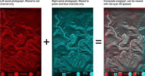
The Relief project consists of a series of composite images created using historical aerial survey photographs from locations across New South Wales (NSW), Australia. Stereo pairs of photographs (adjacent photographs from an aerial survey with overlapping coverage) were digitally scanned from sets of aerial photographs held in my home institution archives and at the National Library of Australia. Selected pairs were modified in Adobe Photoshop software to produce anaglyphs. Anaglyphs are stereo images overlayed and filtered into red and cyan channels so as to appear in 3D when viewed with red/cyan 3D glasses (). An anaglyph uses filters to allow each eye to see only one of the two images in the composite image, substituting normal 3D binocular vision for the left and right vision fields of successive aerial photographs, so viewing common objects from two different angles. Some photographs were further modified by superimposing dark shadowy shapes on the landscape, marking areas where significant environmental changes have taken place. These shadows were added by tracing features from topographic maps and satellite photography available form NSW Spatial Information Exchange (http://maps.six.nsw.gov.au).
Figure 1. Red-cyan anaglyphs are created by overlaying adjacent aerial photographs from a survey flight. Images are digitally filtered using the RGB (Red-Green-Blue) channels.
3. ‘Relief’: background and introduction to works
Relief emerged from a point of inspiration in teaching second-year undergraduate geomorphology students to use stereoscopic images for geomorphic mapping, and the sense of wonder and excitement that some students expressed when two flat images came together to ‘leap out’ in 3D. I routinely use historical aerial imagery in my research that reconstructs river evolution (e.g. CitationMould & Fryirs, 2017, Citation2018), and have become fascinated by the medium. In contrast with more modern sources of spatial data, such as Google Earth (which has transformed virtual spatial experiences; e.g. CitationTooth, 2006), aerial photographs offer a view restricted by the framing of the photograph. This limitation is significant for creating a particular experience, one that is more like viewing a portrait than interpreting data. The viewer is denied distraction, which makes for a slower experience of place with more careful engagement. The affective quality of the aerial images is made more potent with the knowledge that many photographs depict aspects of landscapes that no longer exist, in the sense that they have been irreversibly transformed. In beginning the project, I wanted to share that uneasy feeling that arises from the viewer experiencing a relic.
Images in the series were first released in the form of an experimental self-published magazine (a ‘zine’), presented at the 2016 Zine Fair, Australian Museum of Contemporary Art, Sydney. Since release of the short zine, Relief has been developing to engage more deeply with concepts of agency, responsibility and environmental change. Initially, the images were presented with little background information or context. However, works produced subsequently tend to be more critical, some using shadows to indicate specific changes that have occurred in these landscapes since the photographs were taken, thus incorporating a temporal dimension. This is an important development for the project in that it makes a shift away from novelty, retaining the exciting experience of 3D vision but using that experience to communicate my deeper sense of unease with the loss and change that has occurred.
This paper presents images from the Snowy Mountains region of southeast Australia, Australia (). The works presented in this paper, examples from Relief ( and ), are not maps in the traditional sense, as in a reference text with clear delineations, numerical scale or utility (e.g. navigation). As a collection, they form something closer to a ‘narrative atlas’ (c.f. CitationWood, 2013) that is deliberately ambiguous; the images are small vignettes of specific locations with particular histories, but speak to a broader narrative of impermanence, agency and responsibility (http://www.simonmould.com/relief/). They are best viewed with widely available red/cyan 3D glasses, so appear in 3D, but 3D vision is not critical for understanding the work.
Figure 2. Location map, showing the Snowy Mountain region, southeast Australia, and the approximate area covered by and .
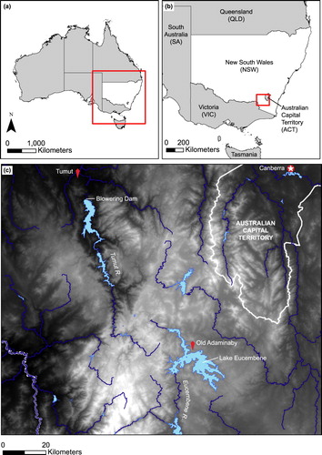
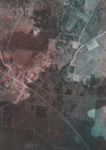
Figure 3. ‘Tumut River (1944)’, showing an active river with meander cutoffs and abandoned channels, and a shadow indicating the footprint of the reservoir that would later be impounded behind the Blowering Dam wall.

Figure 4. ‘Old Adaminaby (1944)’, showing the town of Old Adaminaby, a shadow indicating the footprint of the future Lake Eucembene.
3.1. Tumut River (1944)
‘Tumut River’ () shows an active river whose meander cutoffs and abandoned channels demonstrate its freedom to adjust its form and move across the floodplain in response to flowing water. However, in 1968, the Blowering Dam was built as part of the Snowy Mountains Hydroelectric Scheme, impounding the river and forming a reservoir (lake). As a result, the Tumut River's capacity to adjust was constrained by the stillness of its water. In , a dark shadow indicates the contemporary footprint of the reservoir, the dam wall being the straight line at the top of the shadowy shape. All that is under this shadow – river, hills, trees, roads – has since been made invisible beneath the water.
3.2. Old Adaminaby (1944)
‘Old Adaminaby’ () also depicts an area now partially filled by a reservoir, Lake Eucembene. The farming town of Old Adaminaby (pictured) was relocated to make way for the reservoir and people were still living in the town at the time the photographs were taken (see CitationRaymond, 1958). The dark shadowy area in this image represents the contemporary inundation extent of the lake, which slowly crept up over the town following impoundment in 1958. From time to time, in periods of low rainfall, the waters of Lake Eucembene recede and the ruins of Old Adaminaby re-emerge (CitationMorris, 2006), neither wholly human or natural, but a kind of halfway place where physical and social agencies intersect.
4. Discussion
4.1. Interpreting ‘Relief’
Relief presents 3D portraits of landscapes that invite viewers to see those places in a particular way. This experience of place is influenced by the subject matter (landscapes with particular characteristics and histories) and the aesthetic qualities of the medium (anaglyph). In terms of subject matter, each image presents a story of landscape evolution involving interactions between geological, geomorphic and anthropogenic/social processes. ‘Tumut River’ () and ‘Old Adaminaby’ () both deal with the circumstances and consequences of damming as part of the Snowy Mountains Hydroelectric Scheme. The Scheme was an enormous project undertaken from 1949 to 1974. Construction consisted of ‘seven power stations, 16 major dams, 145 km of interconnected tunnels and 80 km of aqueducts’ (CitationSnowy Hydro, 2017) to divert water from the Murrumbidgee, Snowy and Tumut Rivers for agricultural use and the generation of hydroelectricity. Approximately 100,000 people contributed to the construction, one-third of whom were Australian, and with many of the others coming from Europe after World War II. Thus, the Scheme produced significant changes in both the physical environment and the make-up of communities as new landforms were created and ‘new Australians’ were inducted through labour and the creation of myths that would shape Australian identity (CitationAshton, 2009; CitationGriffin, 2009).
Elsewhere, both in Australia and farther afield, there is a long history of significant social and cultural change resulting from damming; for example, the flooding of Lake Pedder in Tasmania, Australia and the Tryweryn valley in north Wales. In the Tasmanian example, loss of ‘wilderness’ in part sparked the rise of the Green political movement in Australia in the 1970s, which contributed to protection of the iconic Franklin River shortly thereafter (see Crowley, Citation1999). In Wales, the Tryweryn scheme continues as a symbol for the Welsh nationalist movement, having had significant hydropolitical consequences in the region (CitationGriffiths, 2014). In the Snowy Mountains Hydroelectric Scheme, much public discussion, understandably, focuses on the significant engineering feat and its economic and social implications. There is typically far less consideration afforded to the landscapes that were lost, or irreversibly changed, in the process. Damming typically induces significant changes in the behaviour and functioning of rivers and the impacts are in many cases irreversible; for this reason, dams are particularly evocative of the Anthropocene. Relief draws attention to places that were drowned when rivers turned into reservoirs, taking those ‘lost’ places out of the abstract by revealing their forms. This encourages the viewer to consider what has been lost in each case and to engage with these places by witnessing their histories.
In ‘Tumut River’ (), viewers are invited to experience a section of river that can no longer be seen or visited. The section of river underneath the shadowy outline of the lake is a complex environment with a long history of geomorphic evolution, reflected in the many meander cutoffs and abandoned channels that reveal how the river has changed course over time. This complexity in character and behaviour has been lost through damming, which has simplified the environment with the introduction of a homogenous, dark water surface. Complex interactions between water and landforms have been reduced to a simple function of topography: anything below the particular elevation of the dam wall will be inundated. The brutal simplicity of this new engineered environment, constrained by the straight line of the dam wall, is juxtaposed against the elegance of a dynamic geomorphic system. The dark shape of the lake, which hovers over the landscape, allows one static image to represent a process of transformation by superimposing the present on the past.
‘Old Adaminaby’ () shows a small section of Lake Eucembene, where the shadowy shape of the reservoir is encroaching on a small town. Although this represents a similar inundation process as in ‘Tumut River’ (), the framing of this image suggests a different kind of agency for the waters of the former Eucembene River. The dam wall is not visible in this image, and the water appears to be creeping up over the town, seeking out the low-lying areas (). In contrast with ‘Tumut River’, the creeping waters in this image appear indifferent to the hard edges of anthropogenic development, instead responding only to the contours of the bedrock valley. What remains of the human settlement after relocation will be swallowed up and then revealed by the receding water only in periods of low rainfall and out of human control. The superimposition of contemporary water levels on this historical image of Old Adaminaby, taken when it was still inhabited, points to the loss of human relationships with place. Although the town was relocated only a short distance away, the upheaval of a community is a significant task. It would likely have been an unsettling experience for many residents to watch the streets of their town – and its familiar landmarks – disappearing under the rising water. Similarly, the recurrent surfacing of artefacts and ruins as the waters recede likely also brings to the surface difficult memories, entwining human experience of place with the hydrological variability of the reservoir (c.f. CitationGriffiths, 2014).
Others have responded to the physical and relational transformation of rivers by damming in ways that dialogue constructively with Relief. For example, Hywel Griffiths's poetry on the dammed Elan Valley in Wales conveys a similar melancholic feeling for the loss of natural character and behaviour, a parallel with the dark and eerie shapes that foreshadow the loss of place in Relief:
‘There are no currents weaving, ribbon-like,
it's quiet where the waterfall once roared,
the sources and the sink are now divorced’
(CitationGriffiths et al., 2017, p. 6).
However, CitationGriffiths et al. (2017) also articulate an interpretation of the ‘Anthropo(s)cenic’ (CitationMatless, 2017), which recognises the opportunities for new and positive relationships with place, brought about by transformation at Anthropocenic scale (see also CitationTooth, 2016). This tension in human-environment relationships, created by transformation, is captured effectively by Australian artist, Bryden Williams, who has produced works in response to damming in Australia and China (http://brydenwilliams.com). Williams's photographic works in the ‘Hydro-Wilderness’ series examine containment of ‘natural’ forces by anthropogenic materials and the [blurry] distinctions between public (wild) and private (urban) space. ‘On The Yangtze’ is a video work also produced by Williams, on which he reflects: ‘Together we sat in awe of the sheer size and sense of sublime that resided within both the natural and the man made features of the environment.’ This sense that heavily transformed landscapes may simultaneously be characterised as emblematic of extreme human modification, but also beautiful and revered by people (as in CitationGriffiths et al., 2017), is a thought-provoking proposition for the Anthropocene and how we can foster a sense of place in these landscapes. In the Relief project, coming to terms with transformation of human-environment relationships is explored through a process of witnessing as a practice for recognising and processing the consequences – both positive and negative – of change.
Witnessing geomorphic and geological landscapes that have been made invisible is a primary concern for the series of works in Relief. It is inspired by the practice of becoming-witness, which involves ‘drawing people into others’ (including non-humans’) lives’ and both ‘standing as witness’ (sharing/communicating) and ‘bearing witness’ (opening oneself to others; CitationRose & van Dooren, 2017, p. 125). By witnessing ‘lost’ landscapes, it is my intent that a viewer is invited to not only see, but also to care, as they seek to learn about an ‘other’ (in this case, a landscape) and become more receptive – and empathetic – to its past, present and future. Such attentiveness is seen as being critical at a time when we are recognising, more and more, our implication in the causes, consequences and necessary responses to some of our most significant environmental challenges. Viewers of Relief are invited to witness landscapes as an exercise in empathy that might lead to new ways of thinking and acting in relation to landscapes. This is to guard against the ‘social death’ that befalls non-humans when they are seen as dispensable or inconsequential, a process that enables the ecocide associated with the Anthropocene (CitationRigby, 2009; CitationRose & van Dooren, 2017), but in this case applied to the geosphere – perhaps ‘geo-cide’.
Particular aesthetic qualities of the medium used in Relief contribute to an experience conducive to bearing witness. The subject matter and aesthetic in Relief, together make for an uneasy experience of landscapes that have been lost. This experience invites the viewer to reflect on environmental change with the weight of responsibility that comes with recognising the role of humans in that change. Rather than being ‘just images’, Relief is an attempt to create virtual experiences of places that offer more to the viewer than the raw data (aerial photographs) are capable of. The 3D effect is the most prominent element of the visual aesthetic because it transforms a flat image into something more dynamic. Not only do the landforms take on height, but in the printed medium, they also shift and bend as the viewer makes small movements with their hands. This makes for a surprisingly tactile experience of holding and peering into a place. The red/cyan 3D glasses also introduce a particular effect. First, they are somewhat isolating and encourage the viewer to focus on the anaglyphic material, since it can be difficult to focus on the non-anaglyphic world when wearing the glasses. Second, they give a shadowy quality to the viewer's vision, since images with variable relief require that the viewer readjust their eyes to focus on particular points. Together, these effects make for an immersive experience that some viewers have described as dream-like and hazy, similar to a distant memory. Although the memory is not the viewer's own, it is a sort of ‘second-hand,’ shared memory, accessible only through documents and artefacts (c.f. CitationGriffiths, 2014). Accessing these memories in order to witness can trigger an emotional response that is similar to – albeit much milder than – the ‘solastalgia’ described by CitationAlbrecht et al. (2007). One of a range of proposed ‘psychoterratic disorders’, solastalgia describes a sense of loss one feels when the environment changes around a person to the point that one can no longer find solace in their surroundings – a kind of homesickness for a place that has been transformed (CitationAlbrecht et al., 2007; CitationMacfarlane, 2016).
4.2. ‘Seeing double’ as a practice
‘Seeing double’ – that is, through art and science – is a practice that can help to recognise and negotiate social, political and place-based context, personally and professionally. I consider this to be consistent with notions of being critical in physical geography (CitationLave et al., 2014; CitationTadaki et al., 2015). The art practice described in this paper is not academic research in its own right, but it has implications for research practice. I seek out places and situations that will allow me to explore intersections of human and non-human agencies. It is at first driven by curiosity, but leads to the compulsion to communicate. This is the responsibility of bearing witness: by witnessing, the researcher is bound to a place through a relationship of morality, or an ethic, that requires them to stand as witness (CitationRose & van Dooren, 2017).
One way that this practice contributes to research is by guiding reflection on the role of researcher in relation to the landscape under study. For example, while Relief celebrates the aerial photograph, it also performs critique on the neutrality of such a data source and the particular context in which these place-based data are interpreted. Although aerial photographs are objective in their rendering of a particular view of a landscape, their production and use are unavoidably political. All aerial photographs are taken for a reason and do not exist as neutral artefacts. For example, the 1944 set of aerial photographs from which ‘Tumut River’ () and ‘Old Adaminaby’ () were sourced were taken specifically for the purpose of scoping and planning the Snowy Mountains Hydroelectric Scheme; i.e. for understanding the landscape so to be able to transform it. It is likely that not all members of the national-level committee responsible for this project were familiar with the region concerned and would have relied on these aerial photographs – along with maps and other resources – to make important decisions concerning this landscape's future. Hence, it is significant that these photographs represent the landscape in a particular way. The scale of the photographs is important, keeping in mind that scale can variously make objects and patterns visible or invisible, pronounced or diminished (CitationWood & Fels, 1992). Temporality is also a concern here: because aerial photographs represent a scene as it was for only a fraction of a second, they make invisible certain variabilities and tend to present the landscape as inert. The particular view of these landscapes provided by aerial survey creates particular possibilities for interpretation, making the photographs powerful beyond their face value.
The fact that these particular photographs would have been used in the design of systems and processes that would so significantly transform their subjects makes their repurposing in Relief all the more powerful. By modifying these photographs and mobilising them as tools for witnessing, Relief ‘reclaims’ their political power for an alternative, critical purpose. The implication for scientific practice is that all spatial data, and their interpretation, are the product of particular, contingent framings – some subtle, some not so subtle – that are deserving of critique when making interpretations that aim to describe the world (c.f. CitationHarley, 1989; Harvey & Chrisman, Citation1998; CitationKitchin & Dodge, 2007). These framings are produced by inescapable social, political and place-based contexts. The influence of context on data collection and interpretation does not suggest that objectivity in science is impossible. Rather, it supports an argument for critical engagement with that context as part of a process of reflection and situated practice in science (c.f. CitationSuchet, 2002) rather than practicing objectivity by insisting on value neutrality. Art-science practices, like in Relief, can help to draw attention to the social and political context in which technical interpretations and decisions are made, encouraging critical reflection within the sciences that is consistent with analysis of the co-production of physical and social landscapes (CitationAshmore, 2015; CitationLinton & Budds, 2014).
Recognising our social, political and place setting is all the more important in the context of the Anthropocene as we realise just how closely (and complexly) linked are the futures of humans and non-humans. As a matter of inherent moral concern (as opposed to a neutral issue become politicised; CitationLatour, 2005; CitationStengers, forthcoming), the Anthropocene requires thinking that traverses fact and feeling and extends beyond disciplines to answer the question ‘how should we live?’ (CitationCastree, 2014). Scientists are active in remaking the world, materially and conceptually, so our institutional, intellectual and cultural settings, which influence our work, can have real implications for the material world and surrounding discourse (CitationTadaki et al., 2014). Hard engineering and ‘techno-fixes’ cannot be the primary response to the challenges of the Anthropocene as these are the very kinds of responses that have created many of our present problems (CitationChakrabarty, 2009). Critical reflection on the place of the geoscientist can contribute meaningfully to reframing public understandings of landscapes and environmental systems in ways that recognise relationships and agencies and, particularly, do not diminish the agencies of the geosphere (CitationClark, 2011). Respect for environmental agencies and natural systems is at the heart of ‘softer’ modes of human intervention, which characterise contemporary best practice environmental management (e.g. CitationBiron et al., 2014; CitationFryirs & Brierley, 2009).
Geosciences and art (particularly visual arts) can work together to both support and critique in constructive ways. Rather than either being consumed or appropriated by the other, perhaps the most interesting science-art projects could be described as ‘more than art, more than science’ – hybridisation rather than homogenisation (CitationMarston & De Leeuw, 2013). Relief demonstrates one model of scientist-as-artist, but collaborations of scientists with artists can also form productive relationships capable of opening up new and creative ways of practicing science and art (e.g. CitationDixon, Hawkins, & Straughan, 2012; CitationGibbs, 2014; CitationGriffiths et al., 2017; CitationHawkins, 2011; CitationMarston & De Leeuw, 2013; CitationTooth et al., 2016). As argued by CitationDixon et al. (2012, p. 242), ‘collaborations can produce novel narratives that no longer “fit” in the established spaces of the journal and the gallery, the field site [or laboratory] and the studio.’ Such possibilities for transdisciplinary work hold promise for finding ways to address significant social, political and environmental concerns that also reach across and outside of traditional intellectual and cultural boundaries. By choosing to ‘see double’, researchers may renegotiate their position in relation to the subjects of their research and the people who also relate to those places in different ways.
5. Conclusion
The Relief project highlights two primary opportunities for crossover between art and geosciences. First, that repurposing scientific materials and methods can bring viewers into different ways of seeing and appreciating landscapes and their histories. Second, that art practice can support a process of situating the researcher by providing an opportunity to explore and reflect on personal and professional relationships with society, politics and place. Both of these ‘outcomes’ are embedded in a practice of witnessing, as clarified in this paper, which positions the witness in relation – and moral engagement – with others. Repositioning humans in relation with society, politics and place is necessary for the task of responding to significant environmental concerns in the Anthropocene, which inherently cross technical, social and cultural terrain.
Software
Maps were created using Adobe Photoshop CS6 and Adobe InDesign CS6.
Supplemental Material
Download PDF (2.7 MB)Acknowledgments
Aerial photographs were sourced from the National Library of Australia (Canberra, Australian Capital Territory) and Macquarie University, Department of Environmental Sciences. My doctoral candidature is supported by the Australian Government's Research Training Program. Kirstie Fryirs provided helpful comments on a draft of this paper. Two reviewers, Ken Gregory and Hywel Griffiths, along with a Special Issue editor, Stephen Tooth, provided detailed and thoughtful comments that significantly improved the quality of this manuscript.
Disclosure statement
No potential conflict of interest was reported by the author.
ORCID
Simon A Mould http://orcid.org/0000-0003-0029-8719
References
- Albrecht, G., Sartore, G. M., Connor, L., Higginbotham, N., Freeman, S., Kelly, B., … Pollard, G. (2007). Solastalgia: The distress caused by environmental change. Australasian Psychiatry, 15(Suppl 1), S95–S98. doi: 10.1080/10398560701701288
- Ashmore, P. (2015). Towards a sociogeomorphology of rivers. Geomorphology, 251, 149–156. doi: 10.1016/j.geomorph.2015.02.020
- Ashton, P. (2009). ‘The birthplace of Australian multiculturalism?’ Retrospective commemoration. Participatory Memoralisation and Official Heritage. International Journal of Heritage Studies, 15(5), 381–398. doi: 10.1080/13527250903072724
- Biron, P. M., Buffin-Belanger, T., Larocque, M., Chone, G., Cloutier, C. A., Ouellet, M. A., … Eyquem, J. (2014). Freedom space for rivers: A sustainable management approach to enhance river resilience. Environmental Management, 54(5), 1056–1073. doi: 10.1007/s00267-014-0366-z
- Brown, A. G., Tooth, S., Bullard, J. E., Thomas, D. S. G., Chiverrell, R. C., Plater, A. J., … Aalto, R. (2017). The geomorphology of the Anthropocene: Emergence, status and implications. Earth Surface Processes and Landforms, 42(1), 71–90. doi: 10.1002/esp.3943
- Castree, N. (2014). The Anthropocene and geography III: Future directions. Geography Compass, 8(7), 464–476. doi: 10.1111/gec3.12139
- Chakrabarty, D. (2009). The climate of history: Four theses. Critical Inquiry, 35(Winter), 197–222. doi: 10.1086/596640
- Clark, N. (2011). Inhuman nature: Sociable life on a dynamic planet. London: SAGE Publications.
- Crowley, K. (1999). Lake Pedder’s loss and failed restoration: Ecological politics meets liberal democracy in Tasmania. Australian Journal of Political Science, 34(3), 409–424. doi: 10.1080/10361149950317
- Crutzen, P. (2002). Geology of mankind. Nature, 415(23). doi: 10.1038/415023a
- Dixon, D. P., Hawkins, H., & Straughan, E. R. (2012). Wonder-full geomorphology: Sublime aesthetics and the place of art. Progress in Physical Geography, 37(2), 227–247. doi: 10.1177/0309133312457108
- Fryirs, K. A., & Brierley, G. J. (2009). Naturalness and place in river rehabilitation. Ecology & Society, 14(1), 1–10. doi: 10.5751/ES-02789-140120
- Gibbs, L. (2014). Arts-science collaboration, embodied research methods, and the politics of belonging: ‘SiteWorks’ and the Shoalhaven River. Australia. Cultural Geographies, 21(2), 207–227. doi: 10.1177/1474474013487484
- Griffin, G. (2009). Selling the snowy: The snowy mountains scheme and national mythmaking. Journal of Australian Studies, 27(79), 39–49. doi: 10.1080/14443050309387886
- Griffiths, H. M. (2014). Water under the bridge? Nature, memory and hydropolitics. Cultural Geographies, 21(3), 449–474. doi: 10.1177/1474474013510109
- Griffiths, H. M., Goodwin, G., Leevil, T., Salisbury, E., Tooth, S., & Roberts, D. (2017). Searching for an Anthropo(s)cene in the uplands of mid-Wales. GeoHumanities, 1–13. doi: 10.1080/2373566x.2017.1329631
- Harley, J. B. (1989). Deconstructing the map. Cartographica, 26(2), 1–20. doi: 10.3138/E635-7827-1757-9T53
- Harvey, F., & Chrisman, N. (1998). Boundary objects and the social construction of GIS technology. Environment and Planning A, 30, 1683–1694. doi: 10.1068/a301683
- Hawkins, H. (2011). Dialogues and doings: Sketching the relationships between geography and art. Geography Compass, 5(7), 464–478. doi: 10.1111/j.1749-8198.2011.00429.x
- Head, L. (2008). Is the concept of human impacts past its use-by date? The Holocene, 18(3), 373–377. doi: 10.1177/0959683607087927
- Kitchin, R., & Dodge, M. (2007). Rethinking maps. Progress in Human Geography, 31(3), 331–344. doi: 10.1177/0309132507077082
- Latour, B. (2005). Reassembling the social: An introduction to actor-network-theory. Oxford: Oxford University Press.
- Latour, B. (2014). Agency at the time of the Anthropocene. New Literary History, 45(1), 1–18. doi: 10.1353/nlh.2014.0003
- Lave, R., Wilson, M. W., Barron, E. S., Biermann, C., Carey, M. A., Duvall, C. S., … Van Dyke, C. (2014). Intervention: Critical physical geography. The Canadian Geographer / Le Géographe canadien, 58(1), 1–10. doi: 10.1111/cag.12061
- Lewin, J., & Macklin, M. G. (2014). Marking time in geomorphology: Should we try to formalise an Anthropocene definition? Earth Surface Processes and Landforms, 39(1), 133–137. doi: 10.1002/esp.3484
- Linton, J., & Budds, J. (2014). The hydrosocial cycle: Defining and mobilizing a relational-dialectical approach to water. Geoforum; Journal of Physical, Human, and Regional Geosciences, 57, 170–180. doi: 10.1016/j.geoforum.2013.10.008
- Macfarlane, R. (2016). Generation Anthropocene: How humans have altered the planet for ever. The Guardian. Retrieved from https://www.theguardian.com/books/2016/apr/01/generation-anthropocene-altered-planet-for-ever
- Marston, S. A., & De Leeuw, S. (2013). Creativity and geography: Toward a politicized intervention. The Geographical Review, 103(2), iii–xxvi. doi: 10.1111/gere.12001
- Maslin, M. A., & Lewis, S. L. (2015). Anthropocene: Earth system, geological, philosophical and political paradigm shifts. The Anthropocene Review, 2(2), 108–116. doi: 10.1177/2053019615588791
- Matless, D. (2017). The Anthroposcenic. Transactions of the Institute of British Geographers, 42(3), 363–373. doi: 10.1111/tran.12173
- Meybeck, M. (2003). Global analysis of river systems: From earth system controls to Anthropocene syndromes. Philosophical Transactions of the Royal Society of London B Biological Sciences, 358(1440), 1935–1955. doi: 10.1098/rstb.2003.1379
- Morris, L. (2006, 23 September). Mary’s quite contrary: church born again in village of the dammed, The Sydney Morning Herald. Retrieved from http://www.smh.com.au/news/national/marys-quite-contrary-church-born-again-in-the-village-of-the-dammed/2006/09/22/1158431904489.html
- Mould, S. A., & Fryirs, K. (2017). The Holocene evolution and geomorphology of a chain of ponds, southeast Australia: Establishing a physical template for river management. Catena, 149, 349–362. doi: 10.1016/j.catena.2016.10.012
- Mould, S. A., & Fryirs, K. (2018). Contextualising the trajectory of river recovery with social and environmental history for river management. Applied Geography, 94, 130–146. doi: 10.1016/j.apgeog.2018.03.008
- Mould, S. A., Fryirs, K., & Howitt, R. (2018). Practicing sociogeomorphology: Relationships and dialogue in river research and management. Society & Natural Resources, 31. doi: 10.1080/08941920.2017.1382627
- Muecke, S. (2006). What the cassowary does not need to know. Australian Humanities Review, 39–40. Retrieved from http://www.australianhumanitiesreview.org/archive/Issue-September-2006/muecke.html#_edn1
- Raymond, R. (Writer). (1958). A town to be drowned. Sydney: Australian Broadcasting Corporation. Retrieved from https://aso.gov.au/titles/tv/town-to-be-drowned/clip1/
- Rigby, K. (2009). Writing in the Anthropocene: Idle chatter of ecoprophetic witness? Australian Humanities Review, 47. Retrieved from http://www.australianhumanitiesreview.org/archive/Issue-November-2009/rigby.html
- Rose, D. B., & van Dooren, T. (2017). Encountering a more-than-human world. In U. K. Heise, J. Christensen, & M. Niemann (Eds.), The Routledge companion to the environmental humanities (pp. 120–128). Abingdon: Taylor & Francis.
- Snowy Hydro. (2017). The history of the snowy mountains scheme. Retrieved from http://www.snowyhydro.com.au/our-energy/hydro/the-history/
- Steffen, W., Crutzen, P. J., & McNeill, J. R. (2007). The Anthropocene: Are humans now overwhelming the great forces of nature? Ambio, 36(8), 614–621. doi: 10.1579/0044-7447(2007)36[614:TAAHNO]2.0.CO;2
- Stengers, I. (Forthcoming). Another science is possible: A manifesto for slow science. Polity Press.
- Suchet, S. (2002). ‘Totally wild’? Colonising discourses, indigenous knowledges and managing wildlife. Australian Geographer, 33(2), 141–157. doi: 10.1080/00049180220150972
- Tadaki, M., Brierley, G., & Cullum, C. (2014). River classification: Theory, practice, politics. Wiley Interdisciplinary Reviews: Water, 1(4), 349–367. doi: 10.1002/wat2.1026
- Tadaki, M., Brierley, G., Dickson, M., Le Heron, R., & Salmond, J. (2015). Cultivating critical practices in physical geography. The Geographical Journal, 181(2), 160–171. doi: 10.1111/geoj.12082
- Tooth, S. (2006). Virtual globes: A catalyst for the re-enchantment of geomorphology? Earth Surface Processes and Landforms, 31(9), 1192–1194. doi: 10.1002/esp.1383
- Tooth, S. (2016). A glossary for the Anthropocene. Retrieved from https://stephentooth.wordpress.com/2016/03/09/a-glossary-for-the-anthropocene/
- Tooth, S., Viles, H. A., Dickinson, A., Dixon, S. J., Falcini, A., Griffiths, H. M., … Whalley, B. (2016). Visualizing geomorphology: Improving communication of data and concepts through engagement with the arts. Earth Surface Processes and Landforms, 41(12), 1793–1796. doi: 10.1002/esp.3990
- Urban, M. (2002). Conceptualizing anthropogenic change in fluvial systems: Drainage development on the Upper Embarras River, Illinois. The Professional Geographer, 54(2), 204–217. doi: 10.1111/0033-0124.00326
- Wohl, E. (2013). Wilderness is dead: Whither critical zone studies and geomorphology in the anthropocene? Anthropocene, 2, 4–15. doi: 10.1016/j.ancene.2013.03.001
- Wood, D. (2013). Everything sings: Maps for a narrative atlas (2nd ed.). Los Angeles: Siglio Press.
- Wood, D., & Fels, J. (1992). The power of maps. New York: The Guilford Press.