
Abstract
Identification of potential critical habitat, seasonal distributions, and movements within and between river systems is important for protecting the Gulf of Maine (GOM) distinct population segment of Atlantic Sturgeon Acipenser oxyrinchus oxyrinchus. To accomplish these objectives, we captured Atlantic Sturgeon from four GOM rivers (Penobscot, Kennebec system, Saco, and Merrimack) and tagged 144 individuals (83.3–217.4 cm TL) internally with uniquely coded acoustic transmitters. Tagged fish were detected from 2006 to 2014 by primary receiver arrays that were deployed in the four GOM rivers or were detected opportunistically on a secondary group of receivers deployed within the GOM and along the continental shelf. Tagged Atlantic Sturgeon were documented at three spawning areas in the Kennebec system in June and July, including an area that became accessible in 1999 when Edwards Dam was removed. The majority (74%) of tagged fish were detected in the estuaries of the four GOM rivers, primarily in May–October. They spent most of their time in a 45-km reach within the Kennebec system but occupied more limited areas (≤5-km reach) within the Penobscot, Saco, and Merrimack rivers. Approximately 70% of the tagged fish were detected in GOM coastal waters and aggregated in the Bay of Fundy (May–January), offshore of the Penobscot River (September–February and May), offshore of the Kennebec River (September–February), in Saco Bay and the Scarborough River (July–November), and along the eastern Massachusetts coast between Cape Ann and Cape Cod (April–February). Nine tagged Atlantic Sturgeon (7%) left the GOM; three of those individuals moved north as far as Halifax, Nova Scotia, Canada, and six moved south as far as the James River, Virginia. Information obtained in this study has been used to make recommendations to avoid or reduce the impacts of in-water projects on Atlantic Sturgeon.
Received July 15, 2016; accepted November 27, 2016
As an anadromous member of the Acipenseriformes, one of the most imperiled groups of fishes (Birstein et al. Citation1997), the Atlantic Sturgeon Acipenser oxyrinchus oxyrinchus is recognized as needing protection in both marine and riverine habitats. The species is long lived and late maturing, with a historic range along the East Coast of North America from Hamilton Inlet, Labrador, Canada, to the Saint Johns River, Florida (Scott and Crossman Citation1973). Atlantic Sturgeon once were very abundant (Armstrong and Hightower Citation2002) and supported a large U.S. fishery for caviar that started in 1870, peaked in 1890, and collapsed in 1901 (Smith and Clugston Citation1997; Secor and Waldeman Citation1999). In Maine, sporadic exploitation of sturgeon, which may have included the Shortnose Sturgeon A. brevirostrum, began earlier and declined earlier, with the first documented fishery being initiated in 1628 (Wheeler and Wheeler Citation1878), the largest recorded harvest (~145 metric tons) occurring in 1849, and the harvest declining to approximately 5.7 metric tons by 1880 (Atkins Citation1887).
Coastwide management of Atlantic Sturgeon began in 1988 when the Atlantic States Marine Fisheries Commission (ASMFC) began developing a fisheries management plan for the species that was adopted 2 years later (ASMFC Citation1990). Subsequently, all member states and jurisdictions imposed either a moratorium or a size limit on the Atlantic Sturgeon fishery in their waters. After completing a stock assessment, ASMFC (Citation1998) instituted a 40-year moratorium on the harvest of Atlantic Sturgeon. That same year, Atlantic Sturgeon were formally retained on the federal species of concern list. Nearly a decade later, the Atlantic Sturgeon Status Review Team (ASSRT Citation2007) analyzed all available information on Atlantic Sturgeon and concluded that the species could be divided into five distinct population segments (DPSs). In 2012, the National Marine Fisheries Service (NMFS) listed the Gulf of Maine (GOM) DPS of Atlantic Sturgeon as threatened and the New York Bight, Chesapeake Bay, Carolina, and South Atlantic DPSs as endangered under the Endangered Species Act (ESA; NMFS Citation2012a, Citation2012b).
Little information about the presence of Atlantic Sturgeon and the location of potential critical habitat in GOM river systems was available prior to the ESA listing. Studies conducted from 1977 to 2001 in the Kennebec system (which includes the Kennebec, Androscoggin, and Sheepscot rivers) resulted in the capture of 403 Atlantic Sturgeon, the discovery of a spawning area in the upper Kennebec estuary, and identification of several potential foraging areas (Wippelhauser and Squiers Citation2015). An intensive gill-net study in the Merrimack River from 1987 to 1990 captured 36 Atlantic Sturgeon, but there was no evidence of a spawning population in the river (Kieffer and Kynard Citation1993). Seven Atlantic Sturgeon were caught in the Penobscot River during 2006 and 2007, largely in an area of probable foraging habitat (Fernandes et al. Citation2010). In 2007, the presence of Atlantic Sturgeon was documented in the Saco River for the first time in more than 50 years (Little Citation2013; Wheeler et al. Citation2016; Novak et al. Citation2017).
Although the distribution of Atlantic Sturgeon in freshwater and estuarine habitats is well known for some populations (ASSRT Citation2007), the distribution of the species in marine waters is poorly understood throughout its range. Stein et al. (Citation2004a) analyzed data from monitored commercial fishing trips and reported that the bycatch of Atlantic Sturgeon occurred close to shore, generally within the 50-m isobath, although some were caught over deeper waters off the coasts of New Jersey, Rhode Island, and Massachusetts. Laney et al. (Citation2007) reported the incidental capture of 146 Atlantic Sturgeon in cooperative tagging cruises off the coasts of Virginia and North Carolina during winter between 1998 and 2006 and concluded that the fish represented wintering aggregations. Dunton et al. (Citation2010) examined data from five fishery-independent surveys within the mid-Atlantic and northeast regions and reported that juvenile Atlantic Sturgeon were largely confined to coastal water depths less than 20 m and that aggregations tended to occur near the mouth of Chesapeake Bay, Delaware Bay, the Hudson River, and the Kennebec River. Atlantic Sturgeon also are commonly caught in the upper Bay of Fundy and Minas Basin in Canada (Dadswell Citation2006; Taylor et al. Citation2016).
Dams, dredging, and bycatch were identified by NMFS as major factors affecting the GOM DPS of Atlantic Sturgeon (NMFS Citation2012a). In the Kennebec system, the removal of Edwards Dam in 1999 allowed Atlantic Sturgeon to access the remaining 21 km of their historic spawning habitat; however, the use of this area after dam removal was not assessed. In the Penobscot River, two dams (Great Works and Veazie) prevented Atlantic Sturgeon from accessing 21% of their likely historical habitat at the time of the listing; those barriers were removed in 2012 and 2013. In the Merrimack River, two dams (Essex and Pawtucket) constructed during the mid-19th century have prevented Atlantic Sturgeon from reaching 58% of their probable historic habitat (Noon Citation2003) and likely resulted in the extirpation of a Merrimack River spawning population. Another factor affecting Atlantic Sturgeon is dredging, which occurs periodically in the estuarine portions of some GOM rivers. Finally, the incidental capture of Atlantic Sturgeon by commercial fisheries along the entire East Coast is considered a significant threat to the GOM DPS as well as the other four DPSs (NMFS Citation2012a).
Research priorities for Atlantic Sturgeon rangewide include the long-term monitoring of populations, estimation of spawning population abundances, characterization of population genetics, and identification of spawning and nursery grounds (ASSRT Citation2007). To date, critical habitat has not been designated for Atlantic Sturgeon. Our primary objectives for this study were focused on Atlantic Sturgeon in the Kennebec system—the only known spawning population within the GOM DPS—and their relationship to Atlantic Sturgeon in the Penobscot, Saco, and Merrimack River systems. Specifically, we sought to use abundance and telemetry data to identify potential critical habitat, document seasonal distribution, and elucidate migration routes and interbasin movements during 2006–2014. Of particular interest was whether Atlantic Sturgeon were utilizing spawning habitat that became accessible after the removal of Edwards Dam in 1999.
STUDY AREA
The GOM () is a large, semi-enclosed sea located on the East Coast of North America. It is bounded to the west and north by the shorelines of three states (Massachusetts, New Hampshire, and Maine) and two Canadian provinces (New Brunswick and Nova Scotia). The southern border is defined by Cape Cod, Massachusetts, while Georges Bank and Browns Bank form a barrier between the GOM and the Atlantic Ocean.
FIGURE 1. Map of the Gulf of Maine, showing the locations of the four study rivers: the Penobscot River (PR), the Kennebec system (KS; includes the Kennebec, Androscoggin, and Sheepscot rivers), the Saco River (SR), and the Merrimack River (MR). Coastal areas (circled) where Atlantic Sturgeon were concentrated include the Bay of Fundy–Minas Basin area (BOF), offshore of PR, offshore of the Kennebec River, the Saco Bay–Scarborough River area, and the Massachusetts coast from Cape Ann to Cape Cod (CA–CC). Also shown are the locations of receiver arrays (circles), UMOOS buoys (triangles), the Saint John River (SJR), Georges Bank (GB), and Browns Bank (BB). Water depth is indicated by shading: 0–100 m (light gray), 100–200 m (medium gray), and over 200 m (dark gray).
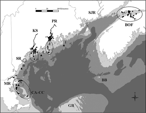
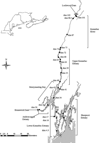
Within the GOM, the four primary study areas (henceforth, the “four study rivers”) included the Kennebec system and the estuarine portions of the Penobscot, Saco, and Merrimack rivers (). Sites within the four study rivers are identified by river kilometer (rkm) as measured from the river mouth in the Kennebec system, Saco River, and Merrimack River and from Verona Island in the Penobscot River. The Kennebec system () includes a barrier-free section of the Kennebec River (rkm 103 to rkm 74); tidal freshwater habitat in the upper Kennebec estuary (rkm 74 to rkm 45), Merrymeeting Bay (rkm 45 to rkm 30), and the 8.4-km-long Androscoggin River estuary; the lower Kennebec estuary, where salinity ranges from 0% to 32% (Mayer et al. Citation1996); and the more saline Sasanoa River, Back River, and Sheepscot River estuary. The natural upstream limit of Atlantic Sturgeon was likely Pejepscot Falls (the current site of Brunswick Dam) at rkm 8.4 in the Androscoggin River estuary and Taconic Falls (the current site of Lockwood Dam) at rkm 103 in the Kennebec River (). From its construction in 1837 to its removal in 1999, Edwards Dam at rkm 74 prevented Atlantic Sturgeon from accessing the Kennebec River. Hereafter, we refer to the reach between rkm 74 and rkm 103 as the “restored Kennebec River.” The Penobscot River estuary extends from the southern end of Verona Island (rkm 0), which marks the transition between the estuary and Penobscot Bay, to Veazie Dam (rkm 47). Constructed near the head of tide in 1833, Veazie Dam was impassable to sturgeon during this study. The remains of Bangor Water Works Dam, which was built in 1874 and breached in 1995, are located approximately 5 km downstream of Veazie Dam. In summer, salinity levels of up to 5‰ can be detected at approximately rkm 30 (Haefner Citation1967). The Saco River estuary extends from its natural mouth (rkm 0) to Saco Falls (rkm 10; current location of Cataract Dam), which separates the estuarine and riverine portions of the system (Little Citation2013). Salinity in the Saco River estuary ranges seasonally from 0‰ to 32‰ (Wargo et al. Citation2009; Tilburg et al. Citation2011). In the Merrimack River estuary, Essex Dam (rkm 46) marks the upstream limit of sturgeon movement. Salinity between rkm 0 and rkm 16 ranges from 0‰ to 27.5‰ (Kieffer and Kynard Citation1993).
FIGURE 2. Detailed map of the Kennebec system in Maine. Receiver locations are indicated by black circles and river kilometer (rkm). Letters indicate the Sasanoa River (S) and the Back River (B). Dam locations are indicated by bold black lines.
METHODS
Capture and tagging
The capture, handling, and tagging of Atlantic Sturgeon complied with NMFS sturgeon handling protocols (Kahn and Mohead Citation2010) and ESA Section 10(a)(1)(A) permit conditions (permits 16526 and 1549); procedures were similar among the four study rivers (). Between 2006 and 2013, Atlantic Sturgeon were captured or recaptured (n = 716) with anchored gill nets set in the study rivers (); after removal from the nets, the fish were held in floating net-pens before being processed. Fish were transferred individually to a holding tank, where TL (cm), FL (cm), and weight (kg) were measured. Each fish was scanned for a PIT tag using an AVID Power Tracker II, V, or VII reader. Untagged individuals received a 23-mm Biomark PIT tag or a 14-mm AVID PIT tag that was injected into the muscle tissue along the base of the dorsal fin. Each Atlantic Sturgeon that was captured in the Kennebec system, Penobscot River, or Saco River also received a uniquely numbered external tag (T-bar tag, Carlin dangler tag, or plastic-tip dart tag). To identify females and their maturation status, a borescope was used (Kynard and Kieffer Citation2002) to examine Atlantic Sturgeon that were captured in the Penobscot and Merrimack rivers. A small fin clip was taken from adult Atlantic Sturgeon (>152 cm TL) captured at spawning areas in the Kennebec system and from all newly captured fish in the Penobscot, Saco, and Merrimack rivers. Tissue samples were stored in ethanol prior to transfer to the New York University (NYU) School of Medicine or the U.S. Geological Survey (USGS) for inclusion in the NMFS genetic archive. Captured fish were grouped into two of four putative life stages based on Bain’s (Citation1997) length categories: late juveniles (>70–149 cm TL) and mature adults (≥150 cm TL).
TABLE 1. Details of gill-net sampling conducted in four Gulf of Maine river systems to capture Atlantic Sturgeon, 2006–2013. Nets were constructed of a single mesh size except in the Kennebec system (all mesh is stretch measure).
Acoustic transmitters () were surgically implanted into the body cavity of 144 Atlantic Sturgeon (83.3–217.4 cm TL) that were captured in the four study rivers. Surgical procedures were performed only on apparently healthy fish when water temperatures were 8–25°C. Individuals selected for tagging were anesthetized with buffered tricaine methanesulfonate (MS-222). A surgical blade was used to make a 3–4-cm incision on one side of the mid-ventral line for insertion of a transmitter that had previously been treated with a disinfectant and (in the Merrimack River) coated with a biologically inert elastomer (Kieffer and Kynard Citation2012). The incision was closed with one or two sets of sutures. After surgery, the fish was allowed to recover in a floating net-pen for at least 15 min.
TABLE 2. Tagging details for Atlantic Sturgeon captured in four Gulf of Maine river systems and tagged with internal or external acoustic transmitters, 2006–2013.
Externally mounted acoustic transmitters were attached to 25 individuals under special circumstances (). In the Kennebec system, 20 adult Atlantic Sturgeon captured at known or suspected spawning areas were tagged with externally mounted Vemco transmitters (3-year battery life) to avoid invasive surgery on prespawn fish. Coated stainless-steel wire was threaded through holes in each end of the transmitter, a neoprene cushion pad, corresponding holes made in the base of the dorsal fin with a PIT tag needle, a second pad, and a hard-plastic disk. The wire ends were secured together with a crimped copper sleeve that was designed to eventually corrode and detach. One individual in the Penobscot River that was captured during the spawning season and that was large enough (196.4 cm TL) to be a mature male was tagged using the same technique. In the Merrimack River, four fish (120.2–143.5 cm TL) were tagged with satellite transmitters (not discussed in this paper) and acoustic transmitters (1-year battery life) to prevent recapture. Each acoustic tag was mounted to the dorsal fin base as was done for Kennebec system fish, but the tag was secured with monofilament as described by Kieffer and Kynard (Citation2012).
Riverine acoustic receiver arrays
Movements of Atlantic Sturgeon were monitored between 2006 and 2014 by compatible receiver arrays that were deployed annually in each of the four study rivers. The arrays were active during ice-free months, generally from March or April through October–early December, although a few receivers that were placed at Shortnose Sturgeon wintering areas in the Penobscot and Merrimack River systems remained in those areas through the winter. Receivers normally were anchored in areas where a single receiver was able to detect tagged fish across the entire width of the river channel. However, if an important river reach was too wide for one receiver, multiple receivers were deployed to maintain a high probability of detection. Receivers were identified by their rkm location, except that two receivers in the Androscoggin River estuary were arbitrarily denoted as rkm 30 and rkm 31. Within the Kennebec system, a single stationary acoustic receiver (Vemco VR2 in 2007; Vemco VR2W in 2008–2014) was deployed at 17–19 sites located between rkm 4.5 and rkm 102 in the main-stem Kennebec River; two receivers were also deployed in the Androscoggin River estuary (). In the Penobscot River system, an array of 82–122 receivers was deployed to monitor up to 39 stations located between 49 rkm downstream of Verona Island (rkm 0) and 46 rkm upstream of the island (G.B.Z., personal observation). In the Saco River system, an array of 10 receivers was deployed from approximately 2 rkm downstream of the river mouth to the first dam at rkm 10 (Little Citation2013; Novak et al. Citation2017). In the Merrimack River, up to 12 receivers were maintained in the river between rkm 1 and rkm 38 and at a location 1 km outside of the river mouth.
Marine receiver arrays
Movements of tagged Atlantic Sturgeon in coastal waters within and outside of the GOM were monitored by concurrent and compatible receiver arrays maintained for varying time periods () by state, federal, and university researchers cooperating through the Atlantic Cooperative Telemetry (ACT) Network (www.theactnetwork.com) or the Ocean Tracking Network (OTN; Dalhousie University; www.oceantrackingnetwork.org). Marine receiver arrays in the GOM were located from the Bay of Fundy and the southern coast of New Brunswick, Canada, to Cape Cod, Massachusetts (). A single array was located north of the GOM in an area off Halifax, Nova Scotia. South of the GOM, arrays extended from Long Island to Chesapeake Bay ().
TABLE 3. Locations and deployment periods for receiver arrays where acoustically tagged Atlantic Sturgeon were detected, including those in the four study rivers and independent arrays maintained by cooperating investigators (GOM = Gulf of Maine; tMOLT = Telemetry Monitoring on Lobster Traps; UMOOS = University of Maine Ocean Observing System). Arrays are listed from north to south, with the exception of the UMOOS buoys, which range from Penobscot Bay to Massachusetts Bay. Some receivers from Cape Cod to Cape Ann were deployed year-round or from October to March. Receivers at the entrance of the Saint John River were deployed year-round.
Ichthyoplankton sampling
From 2009 to 2011, a modified plankton net was used to capture early life stages (eggs and larvae) for purposes of confirming that Atlantic Sturgeon were spawning in the Kennebec system. The 4.3-m-long net was made of 800-μm or 1,600-μm square mesh and had a 1-m-diameter mouth opening that was attached to a “D”-shaped frame. The net was set on the bottom, downstream of a suspected spawning area. The number of sampling events was limited because the goal was only to verify the presence of viable early life stages. Most of the material that was rinsed from the net was immediately preserved in 5% formalin. However, potential sturgeon larvae that were dead or moribund were preserved in 75% ethanol, whereas larvae that were viable were returned to the river. Samples preserved in formalin were sorted in the laboratory under a dissecting microscope, and eggs were transferred to 75% ethanol for subsequent identification according to Jones et al. (Citation1978) and Gilbert (Citation1989). The larvae preserved in ethanol were identified to species via genetic analysis (mitochondrial DNA).
Environmental data
In the Kennebec system, mean daily discharge and mean daily water temperature were recorded to identify the range of environmental conditions that were related to prespawning and spawning behavior. Discharge data were downloaded from two USGS gauging stations: station 01059000 was located in the Androscoggin River approximately 27 km above Brunswick Dam, and station 01049265 was located in the Kennebec River at rkm 87. From 2009 to 2014, a HOBO U10-001 data logger in a waterproof case recorded water temperature approximately 1 m from the bottom at four receiver locations (rkm 30, 42, 68, and 102). High river discharge resulted in the loss of a data logger in 2011 and two data loggers in 2012, and water temperature was estimated from the nearest data logger that was recovered.
Data analysis
Data recorded by the receivers in the four study rivers were downloaded several times during the field season and when the receivers were retrieved in the fall. Data were sorted by transmitter number and date, and invalid codes were removed from further analysis. Detections were plotted for each tagged Atlantic Sturgeon to describe its position (rkm) in the river system over time, allowing us to verify that a given individual was not simultaneously detected in disparate locations. We assumed that all internally tagged Atlantic Sturgeon were equally vulnerable to detection during the study, with the exception of five fish that were tagged in the Penobscot River that were stationary for more than 60 d (G.B.Z., personal observation), resulting in a sample size of 139 tagged individuals.
Spawning activity, which was used to identify critical habitat in the Kennebec system, was inferred from (1) the capture of ripe males in the upper Kennebec estuary and the Androscoggin River estuary and (2) the detection of tagged Atlantic Sturgeon at these locations and in the restored Kennebec River during the putative spawning season from mid-June to mid-July (Wippelhauser and Squiers Citation2015). We defined the time spent at a spawning site as the elapsed time between the first and last detections of an individual at a specific receiver: the receiver at rkm 30 was used for fish spawning in the Androscoggin River estuary and the receiver at rkm 48 was used for fish that spawned in the upper Kennebec estuary and the restored Kennebec River. Most of the tagged Atlantic Sturgeon passed these receivers twice; however, six fish passed the receiver at rkm 48 several times. The time spent downstream of the rkm 48 receiver (0.3–5.0 d) was not included in calculation of the time at the spawning area. Tagged fish that were detected between receivers at rkm 59 and rkm 76 were categorized as occupying spawning habitat in the upper Kennebec estuary, and individuals that were detected by the receiver at rkm 87 or rkm 102 were classified as occupying spawning habitat in the restored Kennebec River. Movements of tagged Atlantic Sturgeon in the other three study rivers showed no indication of spawning activity.
The seasonal occurrence of nonspawning Atlantic Sturgeon in each study river was assessed for each fish by determining the date of its first and last detections in a river system within a given year and the most upstream location at which it was detected. Nonspawning Atlantic Sturgeon included all juveniles as well as those adults that were not detected at a known spawning area during a specific year. This analysis encompassed fish that may have exited and entered a river multiple times during a given year. We also determined how many years each fish returned to a particular river system.
The seasonal occurrence of nonspawning Atlantic Sturgeon along the coast was similarly assessed for each tagged fish. Because cooperating arrays were widespread, we grouped detections into larger hydrographical regions. We included observations from 2014 so that fish tagged between 2006 and 2013 would have an opportunity to be detected at least 1 year after tagging.
RESULTS
We captured 681 Atlantic Sturgeon within the four study rivers between 2006 and 2013. Approximately 96% (n = 652) of the fish were PIT-tagged, and 25% (n = 169) were tagged with acoustic transmitters (144 internal tags; 25 external tags). Thirty-five (5%) of the captured Atlantic Sturgeon were recaptured, resulting in 716 capture events. The sex of 13 Atlantic Sturgeon, all caught in the Kennebec system, was determined during the study. Eight ripe males were caught at spawning areas; three males and two prespawn females sampled from Merrymeeting Bay in August and September were identified during tag implantation. During the 8 years of the study, only four mortalities occurred across all river systems as a result of gill-net sampling.
Kennebec System: Critical Spawning Habitat
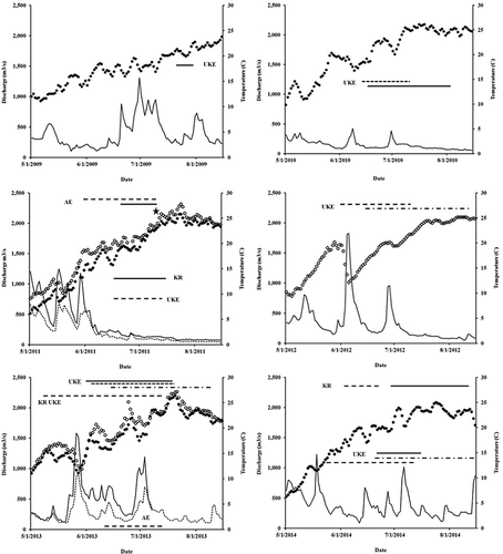
Spawning was confirmed in the Kennebec River and upper Kennebec estuary by the capture of three Atlantic Sturgeon larvae in 2011. Two larvae were caught at rkm 75 in the Kennebec River: one larva was 15 mm TL (captured on July 11), and the other was 10 mm TL (July 12). An additional 15-mm TL larva was caught at rkm 72 in the upper Kennebec estuary on July 11. Bottom water temperature was 23–24°C when the larvae were caught (). Species identification as Atlantic Sturgeon was made for two of the larvae (one was released alive) and was confirmed by mitochondrial DNA analysis (I. Wirgin, NYU School of Medicine, personal communication).
FIGURE 3. Freshwater discharge (m3/s) in the Kennebec River (solid line) and Androscoggin River, Maine (dashed line); bottom water temperature (°C) in the upper Kennebec estuary or the Kennebec River (filled circles) and in the Androscoggin River estuary (open circles); and the putative spawning periods (horizontal lines) in the Kennebec River (KR), upper Kennebec estuary (UKE), and Androscoggin River estuary (AE) based on detections of Atlantic Sturgeon tagged in the Kennebec system (solid line), Penobscot River (short-dashed line), Saco River (long-dashed line), and Merrimack River (dotted–dashed line) during 2009–2014. The star indicates when Atlantic Sturgeon larvae were captured.
During 2009–2011, 39 adult Atlantic Sturgeon (152.0–199.0 cm TL), including some in spawning condition (ripe males releasing milt), were caught between June 16 and July 22 at a previously identified spawning area in the upper Kennebec estuary and at two putative historical spawning areas. Of the 39 adults, 27 fish (including five ripe males, 166.0–197.4 cm TL) were caught in the upper Kennebec estuary between rkm 70 and rkm 74; four individuals (including one ripe male, 188.5 cm TL) were captured from the restored Kennebec River at rkm 75; and eight fish (including one ripe male, 181.4 cm TL) were caught in the Androscoggin River estuary near the receiver at rkm 30 (). Two of the individuals (including the ripe male) captured in the Androscoggin River estuary had been caught and PIT-tagged in the Saco River estuary during the previous year. After their capture at a spawning area, 20 of the 39 fish were tagged externally with acoustic transmitters: 13 from the upper Kennebec estuary, 4 from the restored Kennebec River, and 3 from the Androscoggin River estuary. Seventeen of the tagged Atlantic Sturgeon remained at a spawning area until August 2 at the latest; two moved downstream 12–19 h after being tagged; and one individual was never detected (possibly due to tag failure). After likely spawning, 15 tagged individuals remained in the Kennebec system for up to 60.9 d—primarily in Merrymeeting Bay or the lower Kennebec estuary—before departing the system.
Between 2010 and 2014, 21 adult Atlantic Sturgeon that previously had been caught in the four study rivers and internally tagged were detected at the known or putative spawning areas in the Kennebec system. These probable spawners of undetermined sex included 3 (9%) of 35 fish that were tagged in the Kennebec system, 3 (8%) of 37 individuals that were tagged in the Penobscot River, 9 (18%) of 51 fish that were tagged in the Saco River, and 6 (38%) of 16 individuals that were tagged in the Merrimack River. Twelve individuals were detected at a spawning site in only 1 year, eight fish were present in each of 2 years (seven skipped 1 year, and one skipped 2 years), and one fish was present in three consecutive years, collectively resulting in 31 putative spawning events. Atlantic Sturgeon moved to spawning habitat in the upper Kennebec estuary (16 events) or the Androscoggin River estuary (3 events), or they visited both the upper Kennebec River estuary and the restored Kennebec River within the same year (12 events). Two additional fish that were detected in the upper Kennebec estuary during 2012 may also have spent time in the restored Kennebec River, but the loss of the receivers at rkm 87 and rkm 102 prevented us from determining the upriver extent of their movements in that year.
Tagged Atlantic Sturgeon typically entered the Kennebec system during April and May (mean = May 6; SD = 17.3 d; range = April 11–June 17), moved to spawning areas in June (mean = June 14; SD = 14.7 d; range = May 8–July 20), and remained at a spawning area through July (mean = July 13; SD = 17.2 d; range = June 12–August 20). Water temperatures typically were less than 16.0°C when Atlantic Sturgeon entered the Kennebec system (mean = 10.5°C; SD = 4.1°C; range = 3.7–18.6°C) and were over 16.0°C during the occupation of spawning areas (mean = 20.3°C; SD = 3.2°C; range = 12.9–26.1°C). Freshwater discharge typically was less than 399 m3/s when Atlantic Sturgeon were at spawning areas. However, in 2012, discharge between June 3 and June 11 peaked at 1,824 m3/s in the Kennebec River due to an extreme rain event and caused water temperatures to drop from 20°C to 12.1°C ().
Intrasystem, Intersystem, and Coastal Movements during 2007–2014
The majority (74%) of internally tagged, nonspawning Atlantic Sturgeon were detected in one or more of the four study rivers during the years after tagging (). Fish that were tagged in the Penobscot River returned to that system at the highest rate (31 of 37 fish; 84%), followed by the Saco River (35 of 51 fish; 69%), the Merrimack River (9 of 16 fish; 56%), and the Kennebec system (12 of 35 fish; 34%). Some individuals returned to the Saco River in each of 6 years, to the Penobscot and Merrimack rivers in each of 5 years, and to the Kennebec system in each of 4 years. The majority of Atlantic Sturgeon (63%) were documented as accessing river systems other than the one in which they were tagged. Fifty-nine individuals that were tagged elsewhere were detected in the Kennebec system, including 78% of fish tagged in the Penobscot River, 41% of those tagged in the Saco River, and 56% of individuals tagged in the Merrimack River. Twenty-eight Atlantic Sturgeon that were tagged in other systems entered the Saco River, including 16% of fish tagged in the Penobscot River, 34% of individuals tagged in the Kennebec system, and 63% of fish tagged in the Merrimack River. Twenty-nine fish that were tagged in the other rivers were detected in the Merrimack River, including 19% of individuals tagged in the Penobscot River, 29% of fish tagged in the Kennebec system, and 24% of those tagged in the Saco River. Just six Atlantic Sturgeon tagged in other river systems entered the Penobscot River, along with 10% of fish tagged in the Saco River and 6% of those tagged in the Merrimack River. No fish that were tagged in the Kennebec system were detected entering the Penobscot River.
TABLE 4. Number of Atlantic Sturgeon that were tagged in each of the four study rivers and that were detected by riverine and marine receiver arrays within and to the south of the Gulf of Maine, 2006–2014 (tMOLT = Telemetry Monitoring on Lobster Traps; UMOOS = University of Maine Ocean Observing System). Detection locations are listed from north to south; tagging locations are listed from west to east.
In the months after tagging, eight externally tagged Atlantic Sturgeon displayed movements similar to those of internally tagged fish. Five individuals tagged at a spawning area in the Kennebec system were subsequently detected in the Saco River. One large Atlantic Sturgeon that was tagged in the Penobscot River was later detected in the Kennebec system, although not at a spawning area. One individual that was tagged in the Merrimack River spent the winter in that river and was subsequently detected in the Penobscot River.
Regardless of where they were tagged, nonspawning Atlantic Sturgeon generally entered the Penobscot River and the Kennebec system earlier in the spring and departed from those rivers earlier in the fall relative to the Saco and Merrimack rivers, although these data were not examined statistically. Median immigration dates were May 13 (mean = May 15; SD = 27.8 d) for the Penobscot River, May 30 (mean = June 20; SD = 58.3 d) for the Kennebec system, June 15 (mean = June 18; SD = 52 d) for the Saco River, and July 30 (mean = July 30; SD = 78.1 d) for the Merrimack River. Median emigration dates were September 16 (mean = August 31; SD = 43.5 d) for the Penobscot River, August 25 (mean = August 5; SD = 61.4 d) for the Kennebec system, October 20 (mean = October 17; SD = 32 d) for the Saco River, and October 9 (mean = October 9; SD = 61.5 d) for the Merrimack River.
Nonspawning Atlantic Sturgeon occupied a much larger area in the Kennebec system than in the other three rivers. Tagged Atlantic Sturgeon that entered the Kennebec system spent the majority of their time between rkm 0 and rkm 45. Atlantic Sturgeon in the Penobscot River were concentrated between rkm 20 and rkm 25 (G.B.Z., personal observation). Tagged fish that entered the Saco and Merrimack rivers spent most of their time near the mouth of each estuary (rkm 0 to rkm 2 in the Saco River; rkm –1 to rkm 2 in the Merrimack River).
Ninety-seven (70%) of the 139 Atlantic Sturgeon tagged in the four study rivers were detected outside of those rivers and their associated arrays but remained within the GOM from 2011 to 2014. These detections were concentrated in five general areas along the coast: the Bay of Fundy, offshore of the Penobscot River, offshore of the Kennebec River, in Saco Bay and the Scarborough River, and along the eastern coast of Massachusetts between Cape Ann and Cape Cod (). In the Bay of Fundy, individuals were located at the inner Minas Passage during May–January, with 6% of detections occurring in the winter. Offshore of the Penobscot River, Atlantic Sturgeon were most often detected from September to February and in May. Similarly, tagged fish were detected offshore of the Kennebec River from September to February. In southern Maine, Atlantic Sturgeon were detected in Saco Bay and the Scarborough River during July–November. In the Massachusetts Bay area, Atlantic Sturgeon were detected primarily near Cape Ann, the southern part of Massachusetts Bay, Cape Cod, and the Cape Cod Canal during April–February, with 10% of the detections occurring in winter. Some of the individual University of Maine Ocean Observing System (UMOOS) or Telemetry Monitoring on Lobster Traps (tMOLT) receivers where Atlantic Sturgeon detections occurred were located approximately 5.0–21.5 km offshore and in 62–110 m of water ().
Nine (7%) of the 139 tagged Atlantic Sturgeon moved outside of the GOM during the study period. Two fish tagged in the Penobscot River and one fish tagged in the Kennebec system were detected near Halifax, Nova Scotia, during May, June, and September. One individual that was tagged in the Merrimack River was detected near the mouth of Chesapeake Bay in February and April, and another fish was detected in the Connecticut River and adjacent areas of Long Island Sound during May–August and along the shore of Long Island, New York, and off Rockaway Beach, New York, the following April. Two fish that were tagged in the Kennebec system were detected off the coast of Long Island in January and April–October. Two fish tagged in the Penobscot River were detected off the coast of Long Island during April and May (G.B.Z., personal observation).
DISCUSSION
This research has greatly expanded our understanding of Atlantic Sturgeon in the GOM, particularly the identification of potential critical habitats. Two new spawning areas (Androscoggin River estuary and restored Kennebec River) and a previously identified one (upper Kennebec estuary) in the Kennebec system were used by Atlantic Sturgeon tagged in each of the four study rivers. We determined when Atlantic Sturgeon were present in each study river and where they were concentrated; such information is important for reducing the impacts of dredging, construction projects, and vessel traffic. Our data also provide insight into the wintering habits of GOM Atlantic Sturgeon, which were detected in coastal habitats within the geographical limits of the GOM DPS throughout the year. Detection data provided by other researchers indicated that some adults make annual movements outside of the geographically defined GOM DPS, both to the north and to the south.
Our data indicated that Atlantic Sturgeon use the newly restored Kennebec River for spawning. Although spawning habitat downstream of Edwards Dam in the upper Kennebec estuary and downstream of Brunswick Dam in the Androscoggin River estuary has always been accessible, additional upriver habitat in the Kennebec River only became accessible after Edwards Dam was removed in 1999. Recent dam removals in the Penobscot River have made 12 km of potential spawning habitat accessible to both Shortnose Sturgeon and Atlantic Sturgeon. Research is ongoing to determine whether sturgeon are recolonizing newly accessible habitat in the Penobscot River as they have in the Kennebec River.
The behavior of spawning Atlantic Sturgeon in the Kennebec system was consistent with that described for spawners in other northeast river systems. Adults migrate to freshwater before the spawning season (Vladykov and Greely 1963)—for example, entering the Hudson River from the end of April through May (Dovel and Berggren Citation1983), the Kennebec system from mid-April to early May (this study), and the St. Lawrence River from late May through early July (Scott and Crossman Citation1973). Spawning occurs at temperatures of 13.3–17.8°C in the Delaware River (Borodin Citation1925); at 12.9–26.1°C (June and July) in the Kennebec system (this study); and at 14.5–23.4°C (June and July) in the St. Lawrence River (Hatin et al. Citation2002). After spawning, some male Atlantic Sturgeon remained in the Hudson River until November (Dovel and Berggren Citation1983); some of the postspawn males in the Kennebec system remained there until early October.
Specific estuarine areas in the four study rivers and some bays may be used as foraging areas. Potential foraging areas include rkm 21.0–24.5 in the Penobscot River estuary(Fernandes et al. Citation2010; G.B.Z., personal observation), rkm 0–42 in the Kennebec system (this study), rkm 0–2 in the Saco River (Novak et al. Citation2017), and rkm 0–10 in the Merrimack River estuary (Kieffer and Kynard Citation1993; this study). Large embayments near the Kennebec system, such as Sagadahoc Bay (Fire et al. Citation2012), sandy beaches such as Scarborough Beach (this study), the area around Plum Island, and throughout Cape Cod, may be important sources of foods like the American Sand Lance Ammodytes americanus (Furey and Sulikowski Citation2011). In the Penobscot River, a different forage base—spionid polychaetes—dominates Atlantic Sturgeon diets (Dzaugis Citation2013). Similarly, for aggregating Atlantic Sturgeon sampled in Minas Passage (Bay of Fundy), a high percentage of stomachs (99.7%) contained polychaete worms (McLean et al. Citation2013). Hence, estuarine areas of northern river systems might offer an alternative forage base to the resources available in coastal sandy habitats of the southern GOM coast and Massachusetts.
Information on Atlantic Sturgeon movements and use of habitat in the ocean environment is limited. Our data indicate that Atlantic Sturgeon adults and late juveniles are commonly detectable in the coastal waters of the GOM during summer and fall and less often during winter. All coastal detections were in waters less than 110-m depth and did not have sufficient resolution to determine coastal water depth preferences. Similarly, bycatch data from commercial fisheries and data from fisheries-independent surveys indicated that most Atlantic Sturgeon inhabit shallow inshore areas and may form aggregations at the mouths of large bays or estuaries (Stein et al. Citation2004a, Citation2004b; Laney et al. Citation2007; Dunton et al. Citation2010, Citation2015). Detections from UMOOS buoys in the GOM indicate that Atlantic Sturgeon often move farther offshore in deeper waters during winter. This is consistent with the winter distributions of satellite-tagged Atlantic Sturgeon in the Bay of Fundy (Taylor et al. Citation2016) and with records of occasional captures in deeper offshore waters at that time of year (Collins and Smith Citation1997).
Our study revealed some interesting patterns from a broad ecological perspective. Although the Kennebec system was clearly a central location for Atlantic Sturgeon tagged in the GOM, the most northeast system examined—the Penobscot River—stood out in a couple of ways. Similar numbers of Atlantic Sturgeon tagged in the Penobscot River system entered many other systems, but those tagged elsewhere were less often observed using the Penobscot River. This could be linked to GOM circulation patterns or other features that influence the productivity and movement patterns of these animals and appear to change where the Penobscot River discharges into coastal waters (Tian et al. Citation2015). There was also an apparent influence of latitude based on the pattern of river entry timing, which seems to have been earlier for the fish tagged farther northeast than for those tagged closer to the southern GOM.
Our telemetry study supports the results of recent genetic analysis focused on mixed-stock samples obtained along the Atlantic coast. Based on microsatellite DNA and mitochondrial DNA analysis, Wirgin et al. (Citation2012) determined that 34–36% of the Atlantic Sturgeon captured in Minas Basin and the inner Bay of Fundy originated from the Kennebec system. Similar genetic analyses of Atlantic Sturgeon sampled near the Delaware River mouth revealed that 6.8% of the fish originated from the GOM DPS (Wirgin et al. Citation2015a), as did 10.1% of the Atlantic Sturgeon encountered as bycatch from the GOM to Cape Hatteras, North Carolina (Wirgin et al. Citation2015b). Our study found that the majority of Atlantic Sturgeon that were captured and tagged within the geographic limits of the GOM DPS remained within those limits. A small number of fish (11%) remained in the GOM but moved outside of the area corresponding to the GOM DPS and into Canadian waters. Just nine individuals (7%) exited the GOM and remained outside of the GOM for extensive periods.
Although we identified potential critical habitat, seasonal distributions, and movements of GOM Atlantic Sturgeon, there remain many open questions regarding the relationship among individuals captured in the GOM, particularly due to their long-distance movements within and outside of the GOM. For example, the GOM DPS of Atlantic Sturgeon was identified (defined) using mitochondrial DNA and microsatellite DNA analysis of tissue samples from adults that were captured on suspected breeding grounds in the Kennebec system during 1977–2001 and during the present study. Genetic analysis of Atlantic Sturgeon from the Penobscot River and other GOM river systems would clarify the relatedness among individuals captured in these different systems. Elucidating this relationship would better inform recovery and management of Atlantic Sturgeon based on the remaining anthropogenic threats to the species, particularly dredging activities and fisheries bycatch.
ACKNOWLEDGMENTS
This research was funded by NMFS grants NA06NMF-4720249A, NA07NMF4720053, and NA10NMF4720023. All methods were conducted under National Oceanic and Atmospheric Administration (NOAA) ESA Section 10 Permit numbers 1549, 1578, 1595, 16306, and 16526 for the take of protected species for scientific purposes. Research in the Penobscot River was conducted under the University of Maine Institutional Animal Care and Use Committee protocol numbers A2008-07-01, A2011-06-11, and A2014-05-06. We thank Matthew Altenritter, Jason Bartlett, Greg Beadle, James Beaudry, Toby Bonney, Amy Carlson, Edith Carson, Phillip Dionne, Claire Enterline, Steve Fernandes, Nathaniel Gray, Catherine Johnston, Cheryl Kieffer, Craig King, Kevin Lachapelle, Josh Noll, Mark Pasterczyk, Ian Trefrey, Matthew Wegener, and George Zink for their assistance in capturing and tagging Atlantic Sturgeon and maintaining the receiver arrays. The views expressed herein are those of the authors and do not necessarily reflect the views of the Penobscot River Restoration Trust, the NOAA, or any of their members or subagencies; or the Maine Agricultural and Forest Experiment Station. We also thank the following GOM Coastal Tracking Network, ACT Network, and OTN researchers, staff, and partner organizations that maintained receivers outside the four study rivers and provided data: Jay Barthelotte, Rod Bradford, Robert Branton, Jeremy Broome, Nicholas Buchan, Christian Conroy, Michael Dadswell, Greg DeCelles, Keith Dunton, Michael Frisk, Graham Goulette, Jonathan Grabowski, James Hawkes, David Hebert, William Hoffman, Adrian Jordaan, Richard Karsten, Christina Kennedy, Jeff Kneebone, John Kocik, Matthew Litvak, Martha Mather, Kim McKown, Paul Music, Ron O’Dor, Anna Redden, Tom Savoy, Jinyu Sheng, Greg Skomal, Peter C. Smith, Michael Stokesbury, Brian Tarbox, Winsor Watson, Carter Watterson, Fred Whorisky, Acadia University, Connecticut Department of Energy and Environmental Protection, Dalhousie University, Department of Fisheries and Oceans Canada, Massachusetts Division of Marine Fisheries, Mount Allison University, NMFS, New York Department of Environmental Conservation, Northeastern University, Southern Maine Community College, Stony Brook University, U.S. Department of the Navy, University of Massachusetts–Amherst, University of Massachusetts–Dartmouth, and University of New Hampshire–Durham.
REFERENCES
- Armstrong, J. L., and J. E. Hightower. 2002. Potential for restoration of the Roanoke River population of Atlantic Sturgeon. Journal of Applied Ichthyology 18:475–480.
- ASMFC (Atlantic States Marine Fisheries Commission). 1990. Interstate fishery management plan for Atlantic Sturgeon. ASMFC, Fisheries Management Report 17, Washington, D.C.
- ASMFC (Atlantic States Marine Fisheries Commission). 1998. Amendment 1 to the interstate fishery management plan for Atlantic Sturgeon. ASMFC, Management Report 31, Washington, D.C.
- ASSRT (Atlantic Sturgeon Status Review Team). 2007. Status review of Atlantic Sturgeon (Acipenser oxyrinchus oxyrinchus). ASSRT, Report to the National Marine Fisheries Service, Northeast Regional Office. Available: http://www.nmfs.noaa.gov/pr/pdfs/statusreviews/atlanticsturgeon2007.pdf. (March 2017).
- Atkins, C. G. 1887. The river fisheries of Maine. Pages 673–728 in G. B. Goode, editor. The fisheries and fishing industries of the United States, section V, volume 1. Government Printing Office, Washington, D.C.
- Bain, M. B. 1997. Atlantic and Shortnose sturgeons of the Hudson River: common and divergent life history attributes. Environmental Biology of Fishes 48:237–247.
- Birstein, V. J., W. E. Bemis, and J. R. Waldman. 1997. The threatened status of acipenseriform species: a summary. Environmental Biology of Fishes 48:427–435.
- Borodin, N. 1925. Biological observations on the Atlantic Sturgeon, Acipenser sturio. Transactions of the American Fisheries Society 55:184–190.
- Collins, M. R., and T. I. J. Smith. 1997. Distribution of Shortnose and Atlantic sturgeons in South Carolina. North American Journal of Fisheries Management 17:995–1000.
- Dadswell, M. J. 2006. A review of the status of Atlantic Sturgeon in Canada, with comparison to populations in the United States and Europe. Fisheries 31:218–229.
- Dovel, W. L., and T. J. Berggren. 1983. Atlantic Sturgeon of the Hudson River estuary, New York. New York Fish and Game Journal 30:140–172.
- Dunton, K. J., A. Jordaan, D. O. Conover, K. A. McKown, L. A. Bonacci, and M. G. Frisk. 2015. Marine distribution and habitat use of Atlantic Sturgeon in New York lead to fisheries interactions and bycatch. Marine and Coastal Fisheries: Dynamics, Management, and Ecosystem Science [online serial] 7:18–32.
- Dunton, K. J., A. Jordaan, K. A. McKown, and M. G. Frisk. 2010. Abundance and distribution of Atlantic Sturgeon (Acipenser oxyrinchus) within the northeast Atlantic Ocean, determined from five fishery-independent surveys. U.S. National Marine Fisheries Service Fishery Bulletin 108:450–465.
- Dzaugis, M. P. 2013. Diet and prey availability of sturgeons in the Penobscot River, Maine. Undergraduate thesis. University of Maine, Orono.
- Fernandes, S. J., G. B. Zydlewski, J. D. Zydlewski, G. S. Wippelhauser, and M. T. Kinnison. 2010. Seasonal distribution and movements of Shortnose Sturgeon and Atlantic Sturgeon in the Penobscot River estuary, Maine. Transactions of the American Fisheries Society 139:1436–1449.
- Fire, S. E., J. Pruden, D. Couture, Z. Wang, M.-Y. Dechraoui Bottein, B. L. Haynes, T. Knott, D. Bouchard, A. Lichtenwalner, and G. Wippelhauser. 2012. Saxitoxin exposure in an endangered fish: association of a Shortnose Sturgeon mortality event with a harmful algal bloom. Marine Ecology Progress Series 460:145–153.
- Furey, N. B., and J. A. Sulikowski. 2011. The fish assemblage structure of the Saco River estuary. Northeastern Naturalist 18:37–44.
- Gilbert, C. R. 1989. Species profiles: life histories and environmental requirements of coastal fishes and invertebrates (Mid-Atlantic Bight): Atlantic and Shortnose sturgeons. U.S. Fish and Wildlife Service Biological Report 82 (11.122).
- Haefner, P. A. Jr. 1967. Hydrography of the Penobscot River (Maine) estuary. Journal of the Fisheries Research Board of Canada 24:1553–1571.
- Hatin, D., R. Fortin, and F. Caron. 2002. Movements and aggregation areas of adult Atlantic Sturgeon (Acipenser oxyrinchus) in the St. Lawrence River estuary, Quebec, Canada. Journal of Applied Ichthyology 18:586–594.
- Jones, P. W., F. D. Martin, and J. D. Hardy Jr. 1978. Development of fishes of the Mid-Atlantic Bight: an atlas of eggs, larval, and juvenile stages. Volume 1: Acipenseridae through Ictaluridae. U.S. Fish and Wildlife Service FWS/OBS-78/12.
- Kahn, J., and M. Mohead. 2010. A protocol for use of Shortnose, Atlantic, Gulf, and Green sturgeons. NOAA Technical Memorandum NMFS-OPR-45.
- Kieffer, M., and B. Kynard. 2012. Long-term evaluation of telemetry tagging on Shortnose Sturgeon. Pages 297–320 in B. Kynard, P. Bronzi, and H. Rosenthal, editors. Life history and behaviour of Connecticut River Shortnose and other sturgeons. World Sturgeon Conservation Society, Special Publication 4, Books on Demand, Norderstedt, Germany.
- Kieffer, M. C., and B. Kynard. 1993. Annual movements of Shortnose and Atlantic sturgeon in the lower Merrimack River, Massachusetts. Transactions of the American Fisheries Society 122:378–386.
- Kynard, B., and M. C. Kieffer. 2002. Use of a borescope to determine the sex and egg maturity stage of sturgeons and the effect of borescope use on reproductive structures. Journal of Applied Ichthyology 18:505–508.
- Laney, R. W., J. E. Hightower, B. R. Versak, M. F. Mangold, W. W. Cole Jr., and S. E. Winslow. 2007. Distribution, habitat use, and size of Atlantic Sturgeon captured during cooperative winter tagging cruises, 1988–2006. Pages 167–182 in J. Munro, D. Hatin, J. E. Hightower, K. McKown, K. J. Sulak, A. W. Kahnle, and F. Caron, editors. Anadromous sturgeons: habitat, threats, and management. American Fisheries Society, Symposium 56, Bethesda, Maryland.
- Little, C. 2013. Movement and habitat use of Atlantic (Acipenser oxyrinchus oxyrinchus) and Shortnose Sturgeon (Acipenser brevirostrum) in the Saco River estuary system. Master’s thesis. University of New England, Biddeford, Maine.
- Mayer, L. M., D. W. Townsend, N. R. Pettigrew, T. C. Loder, M. W. Wong, D. Kistner-Morris, A. K. Laursen, A. D. Schoudel, C. Conairis, J. Brown, and C. Newell. 1996. The Kennebec, Sheepscot, and Damariscotta River estuaries: seasonal oceanographic data. University of Maine, Department of Oceanography, Technical Report 9601, Orono.
- McLean, M. F., M. J. Dadswell, and M. J. W. Stokesbury. 2013. Feeding ecology of Atlantic Sturgeon, Acipenser oxyrinchus oxyrinchus Mitchill, 1815 on the infauna of intertidal mudflats of Minas Basin, Bay of Fundy. Journal of Applied Ichthyology 29:503–509.
- NMFS (National Marine Fisheries Service). 2012a. Endangered and threatened wildlife and plants; threatened and endangered status for distinct population segments of Atlantic Sturgeon in the northeast region. Federal Register 44:4(6 February 2012):5880–5912.
- NMFS (National Marine Fisheries Service). 2012b. Endangered and threatened wildlife and plants; final listing determinations for two distinct population segments of Atlantic Sturgeon (Acipenser oxyrinchus oxyrinchus) in the southeast. Federal Register 77:24(6 February 2012):5914–5982.
- Noon, J. 2003. Fishing in New Hampshire. Moose County Press, Warner, New Hampshire.
- Novak, A. J., A. E. Carlson, C. R. Wheeler, G. S. Wippelhauser, and J. A. Sulikowski. 2017. Critical foraging habitat of Atlantic Sturgeon based on feeding habits, prey distribution, and movement patterns in the Saco River estuary, Maine. Transactions of the American Fisheries Society 146:308–317.
- Scott, W. B., and E. J. Crossman. 1973. Freshwater fishes of Canada. Fisheries Research Board of Canada Bulletin 184.
- Secor, D. H., and J. R. Waldeman. 1999. Historical abundance of Delaware Bay Atlantic Sturgeon and potential rate of recovery. Pages 203–216 in J. A. Musick, editor. Life in the slow lane: ecology and conservation of long-lived marine animals. American Fisheries Society, Symposium 23, Bethesda, Maryland.
- Smith, T. I. J., and J. P. Clugston. 1997. Status and management of Atlantic Sturgeon, Acipenser oxyrinchus, in North America. Environmental Biology of Fishes 48:335–346.
- Stein, A. B., K. D. Friedland, and M. Sutherland. 2004a. Atlantic Sturgeon marine bycatch and mortality on the continental shelf of the northeast United States. North American Journal of Fisheries Management 24:171–183.
- Stein, A. B., K. D. Friedland, and M. Sutherland. 2004b. Atlantic Sturgeon marine distribution and habitat use along the northeastern coast of the United States. Transactions of the American Fisheries Society 133:527–537.
- Taylor, A. D., K. Ohashi, J. Sheng, and M. K. Litvak. 2016. Oceanic distribution, behaviour, and a winter aggregation area of adult Atlantic Sturgeon, Acipenser oxyrinchus oxyrinchus, in the Bay of Fundy, Canada. PLOS (Public Library of Science) ONE [online serial] 11(4):e0152470.
- Tian, R., C. Chen, J. Qi, R. Ji, R. Beardsley, and C. Davis. 2015. Model study of nutrient and phytoplankton dynamics in the Gulf of Maine: patterns and drivers for seasonal and interannual variability. ICES Journal of Marine Science 72:388–402.
- Tilburg, C. E., S. M. Gill, S. I. Zeeman, A. E. Carlson, T. W. Arienti, J. A. Eickhorst, and P. Yund. 2011. Characteristics of a shallow river plume: observations from the Saco River Coastal Observing System. Estuaries and Coasts 34:785–799.
- Vladykov, V. D., and J. R. Greeley. 1963. Order Acipenseroidei. Pages 24–60 in H. B. Bigelow, editor. Fishes of the western North Atlantic, part 3: short-rayed bony fishes. Memoir Sears Foundation for Marine Research, Number I, Yale University, New Haven, Connecticut.
- Wargo, A. M., C. E. Tilburg, W. B. Driggers, and J. A. Sulikowski. 2009. Observations on the distribution of ichthyoplankton within the Saco River estuary system. Northeastern Naturalist 16:647–654.
- Wheeler, C. R., A. J. Novak, G. S. Wippelhauser, and J. A. Sulikowski. 2016. Using circulating reproductive hormones for sex determination of Atlantic Sturgeon (Acipenser oxyrinchus oxyrinchus) in the Saco River estuary, Maine. Conservation Physiology [online serial] 4(1):cow059.
- Wheeler, G. A., and H. W. Wheeler. 1878. History of Brunswick, Topsham, and Harpswell, Maine. Alfred Mudge and Son Printers, Boston.
- Wippelhauser, G. S., and T. S. Squiers. 2015. Shortnose Sturgeon and Atlantic Sturgeon in the Kennebec River system, Maine: a 1977–2001 retrospective of abundance and important habitat. Transactions of the American Fisheries Society 144:591–601.
- Wirgin, I., M. W. Breece, D. A. Fox, L. Maceda, K. W. Wark, and T. King. 2015a. Origin of Atlantic Sturgeon collected off the Delaware coast during spring months. North American Journal of Fisheries Management 35:20–30.
- Wirgin, I., L. Maceda, C. Grunwald, and T. King. 2015b. Population origin of Atlantic Sturgeon Acipenser oxyrinchus oxyrinchus by-catch in the U.S. Atlantic coast fisheries. Journal of Fish Biology 86:1251–1270.
- Wirgin, I., L. Maceda, J. R. Waldeman, S. Wehrell, M. Dadswell, and T. King. 2012. Stock origin of migratory Atlantic Sturgeon in Minas Basin, inner Bay of Fundy, Canada, determined by microsatellite and mitochondrial DNA analysis. Transactions of the American Fisheries Society 141:1389–1398.