Abstract
If management of water resources is to fully take into account the requirements of the environment, it will benefit from quantitative predictions of the ecological effects of river flow alterations. A significant relationship between flow reductions caused by groundwater abstraction and ecological conditions (as measured by relevant biotic indices) has been shown in streams in the midlands of England. In this article, we combine this relationship with hydrological indices derived from calibrated regional groundwater models to assess river reaches that are likely to be ecologically impacted by abstraction and might consequently be at risk of failing to meet EC Water Framework Directive standards. We demonstrate the application of this method within the framework of the Ecological Limits of Hydrologic Alteration (ELOHA) approach to making water resource decisions. We provide examples of how this approach can be used to assess the implications of different groundwater abstraction scenarios for river water bodies.
Editor D. Koutsoyiannis; Guest editor M. Acreman
Citation Streetly, M.J., Bradley, D.C., Streetly, H.R., Young, C., Cadman D., and Banham, A., 2014. Bringing groundwater models to LIFE: a new way to assess water resource management options. Hydrological Sciences Journal, 59 (3–4), 578–593.
Résumé
Si la gestion des ressources en eau doit prendre pleinement en compte les besoins de l’environnement, elle bénéficiera des prévisions quantitatives des effets écologiques des altérations des écoulements en rivière. Une relation significative entre les réductions de débit causées par les prélèvements en eau souterraine et les conditions écologiques (telles que mesurées par des indices biotiques pertinents) a été démontrée pour des cours d’eau du centre de l’Angleterre. Dans cet article, nous combinons cette relation avec des indices hydrologiques issus de modèles hydrogéologiques régionaux, calés de manière à déterminer les tronçons de rivière susceptibles d’être impactés écologiquement par les prélèvements et qui, par conséquent, pourraient présenter le risque de ne pas répondre aux normes de la Directive cadre sur l’eau. Nous décrivons l’application de cette méthode dans le cadre de l’approche ELOHA (Ecological Limits Of Hydrologic Alteration—limites écologiques liées aux modifications hydrologiques) pour la prise de décision sur les ressources en eau. Nous fournissons des exemples sur la façon dont cette approche peut être utilisée pour évaluer les conséquences de différents scénarios de prélèvement d’eau souterraine sur les cours d’eau.
INTRODUCTION
Water resource managers are increasingly challenged to supply reliable, affordable water to growing human populations, while at the same time protecting aquatic organisms and valued ecosystem services (Poff et al. Citation2010). The concept of environmental flows that unites these competing water requirements is enshrined in water management policies across the world; for example, in the United States, South Africa, Australia and Europe (Dyson et al. Citation2008). Defining the limits of river flow alteration to maintain ecological integrity is central to the management of environmental flows. However, quantitative ecological responses to degrees of river flow alteration have rarely been reported (but see Castella et al. Citation1995, Merritt and Poff Citation2010, Carlisle et al. Citation2012, Bradley et al. Citation2013) and quantitative generalizations that could inform regional or national water management remain elusive (Poff and Zimmerman Citation2010).
Across Europe, the Water Framework Directive (WFD; 2000/60/EC) places the ecological requirements for water at the centre of water management policy. Current assessments indicate that many rivers are already over-abstracted; for example, 15% of river water bodies in the United Kingdom are considered to be failing WFD standards because of the abstraction or impoundment of water (source: Environment Agency UK). In the absence of tools that quantify the direct effects of water abstraction on ecology, the impacts of abstraction can be inferred from flow–biota relationships (e.g. Extence et al. Citation1999, Monk et al. Citation2008, Dunbar et al. Citation2010), conceptual models (SNIFFER Citation2012) or expert opinion (Acreman et al. Citation2008). The uncertainty of current abstraction assessments is of concern given the potential for over-conservative abstraction reductions to place large burdens on water users and to suppress economic growth.
The development of river macro-invertebrate indices, such as the Lotic invertebrate Index for Flow Evaluation (LIFE; Extence et al. Citation1999), creates a possibility of being able to develop quantitative ecological tools for setting abstraction limits. LIFE is an index that aggregates the perceived water velocity requirements of different macro-invertebrate species or families in a river sample, weighted towards their individual abundances. It provides an integrated biological measurement of the effect of flow alteration on the ecological quality of river habitats.
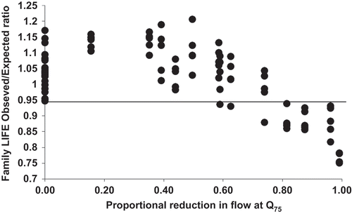
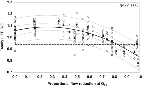
The LIFE index has been related to antecedent river flows in the United Kingdom (Extence et al. Citation1999, Monk et al. Citation2008), taking into account the geomorphic setting of the river channel (Dunbar et al. Citation2010), and most recently, has been related directly to the effect of groundwater abstraction on river flows (Bradley et al. Citation2013). Bradley et al. (Citation2013) reported significant correlations between LIFE observed/expectedFootnote1 (O/E) ratios and the hydrological effect of groundwater abstraction across six streams originating from sandstone aquifers in the English midlands ().
Fig. 1 The relationship between Lotic invertebrate Index for Flow Evaluation (LIFE) observed/expected scores and abstraction effect on medium-low flows (Q75) (Bradley et al. Citation2013). The horizontal line indicates LIFE observed/expected score of 0.94, below which low flows are a possible pressure acting on the ecological community.
In this article, we demonstrate the extension of the hydro-ecological relationships in Bradley et al. (Citation2013) to assess abstraction impacts on macro-invertebrates at stream sites across the sandstone aquifers of the English midlands. The method is applied within the framework of Poff et al. (Citation2010) (ELOHA, ecological limits of hydrological alteration) for developing regional environmental flow standards. Our hydro-ecology method is consistent with ELOHA in four ways: first it is applied at the regional scale across rivers with similar flow regimes and geomorphic features; second, it is based on a hydrological foundation, expressed as degrees of alteration from a naturalized condition; third, ecological metrics have been quantified in response to varying degrees of flow alteration; and fourth, we use groundwater models to apply the method to ungauged analysis nodes across the whole region.
Frameworks for implementing environmental flows, such as ELOHA and downstream response to imposed flow transformation (DRIFT; King et al. Citation2003), also incorporate socio-economics. We have focused only on the scientific approaches to abstraction management in this article, but acknowledge that socio-economics is an equally important component of water resource management. In the case of the WFD, the measures required to achieve good ecological status will be subject to a disproportionate cost test at a national level.
STUDY AREA
The National Environment Programme (NEP) is a programme of actions and investigations for environmental improvement schemes, which ensures that water companies in England and Wales meet European Union Directives, national targets and their statutory environmental obligations. The Environment Agency (UK) produces the NEP after consultation with the water industry and a number of other organizations. The NEP includes investigations into the impact of water abstraction on the environment.
Severn Trent Water Ltd (STWL) supplies water throughout the midlands of England and parts of eastern Wales. It is licensed to abstract water from nearly 200 groundwater sources, mainly in Staffordshire, Shropshire, Worcestershire and Nottinghamshire, and this provides about a third of the supplies (about 600 ML/d (Mega litres per day, i.e. 6.9 m3/s), and so it is a vital component of the company’s operation.
The Environment Agency (UK) identified over 40 licensed groundwater sources (~180 ML/d, 2.1 m3/s) that required investigation by STWL under the NEP in the period 2010–2015. These groundwater abstractions mostly abstract from the Permo-Triassic sandstones supporting flows in streams similar to those assessed in Bradley et al. (Citation2013). The main driver for this work was to restore river flows to rates that support good ecological status or good ecological potential as required by the WFD.
METHODS
The groundwater models
Following a review of its groundwater modelling programme in 1998–1999, the Environment Agency developed a Framework for Groundwater Resources—Conceptual and Numerical Modelling (Brown and Hulme Citation2001). Since that time, the Environment Agency’s nationally coordinated programme of groundwater resource assessment and modelling has resulted in the development of calibrated, transient, regional groundwater models for almost all the major aquifer units in England (Whiteman et al. Citation2012).
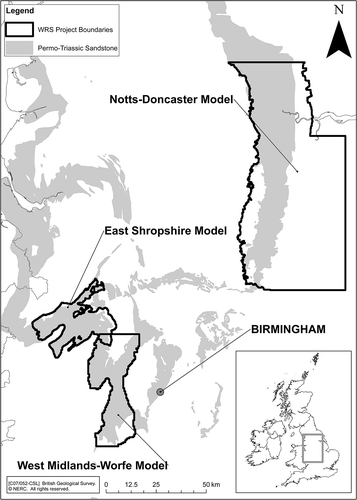
In the Environment Agency’s Midlands Region, groundwater models have been developed for West Midlands Worfe (WMW; Soley et al. Citation2001), East Shropshire (ESM; Streetly and Shepley Citation2005), East Midlands Yorkshire (EMY; Shepley and Soley Citation2009) and Bromsgrove (Streetly and Shepley Citation2010) Permo-Triassic sandstone aquifers, as shown in . The use of these models to derive “natural” summer flows in the associated streams is described in Shepley and Streetly (Citation2007).
Fig. 2 Groundwater models and NEP/RSA investigation areas.
The groundwater models have been constructed to quality criteria (Hulme et al. Citation2002) that are applied by the Environment Agency to all groundwater models used for catchment management. This includes validation of the groundwater models against observed groundwater level time series and total surface water flow time series measured at gauging stations (streamflow gauges for catchments in the range 30–400 km2 with data for the last 30–40 years). In some cases, refinement at a more local scale has been carried out using spot flow gauging data, particularly on reaches where abstraction stress was considered to be significant.
The groundwater models use the MODFLOW code (McDonald and Harbaugh Citation1988) and take inputs from separate recharge models that are not dynamically linked to the groundwater model. The recharge models calculate routed runoff, and total surface flows are then calculated from the combined outputs of the groundwater and recharge models. For the ESM, the recharge model calculates runoff at a sub-catchment scale so that total flows can only be calculated at sub-catchment outflow points. The other three models use the 4R code (Heathcote et al. Citation2004) in which the runoff is routed via a stream network using the same grid as the groundwater model, thus providing inflows to the MODFLOW stream cells. This means that total flow can be calculated for every stream cell (250–500 m) in these models.
The models can be considered to be a reliable tool for assessing different water resource options at the scale at which they have been calibrated. In general, for the sites considered in this study, they are reliable tools for assessing flows at the sub-catchment scale being considered, but their use at the reach scale (<1 km) should be considered as a scoping calculation to be supported by more detailed local data.
While the 4R recharge models calculate a water balance every day, because the Permo-Triassic sandstone responds very slowly to recharge and provides baseflow at a fairly steady rate, the groundwater models typically use a monthly stress period. This means that the total surface water flows calculated by the models are generally monthly average flows. The evaluation techniques presented in this article require assessment of various flow statistics (Q75, Q95, etc.) based on daily flow data. The difference between daily and monthly average flow statistics is discussed in the Appendix, which shows that, for these catchments, it is possible to produce a simple correction factor to produce approximations to the daily flow statistics from monthly average flows calculated by the groundwater models. However, the spatial distribution of groundwater abstraction effects on surface water flows is largely unaffected by this aspect of the models, and application of the correction factor did not significantly affect the reaches considered to be affected by abstraction stress.
The development of these groundwater models has allowed various “predictive scenario” model runs to be carried out in order to simulate potential future conditions. In general, these repeat the climate sequence used in the historic, calibrated run (typically 40 years), starting from the latest simulated heads and flows, but change the abstraction and discharges applied. The key model predictive runs used in this article for the assessment of current impacts on surface water bodies are the following:
– Naturalized model: this represents “natural” conditions in the aquifer, with no abstractions and most other anthropogenic influences removed (however, no change to land use is applied).
– Recent actual model: this represents the aquifer conditions under the current abstraction rates (generally based on actual abstractions averaged over the last 5 yearsFootnote2).
By comparing the results from these two model runs, we can assess the effects that groundwater abstraction has on groundwater levels and surface water flows.Footnote3 Further predictive model runs can then be carried out to assess the implications of different abstraction regimes (or potentially different climate sequences).
Most of the NEP sites under investigation for 2010–2015 were located in catchments for which the Environment Agency had already developed a regional groundwater model. This allows the spatial and temporal effects of groundwater abstraction on streamflows to be assessed more reliably. This is in contrast to the work presented in Bradley et al. (Citation2013), which is based on data from similar investigations by STWL in 2005–2010, on sites that did not have the benefit of a groundwater model for exploring the potential for different water resource options to result in improvements of in-stream ecology.
Integration of groundwater model results with hydro-ecological relationships
The hydro-ecological relationships established at other similar sites in the region by Bradley et al. (Citation2013) () were then used to indicate the likely impact of abstraction on the ecological status of in-stream macro-invertebrate communities using the following categorization:
Green Flow reduction <60% Q75, indicating that impacts of low flows on macro-invertebrates were unlikely in the absence of other pressures.
Yellow Flow reduction 60–80% Q75, indicating that impacts of low flows on macro-invertebrates were possible in the absence of other pressures.
Red Flow reduction >80% Q75, indicating that impacts of low flows on macro-invertebrates were likely in the absence of other pressures.
In applying these categories for this purpose, it is important to note that it was developed using data from sites that are affected by groundwater abstraction. It has been shown that groundwater abstraction impacts on streams sourced from the Permo-Triassic Sandstone, such as these, are fairly constant (in terms of magnitude) across the flow spectrum (Shepley and Streetly Citation2007). In other words, the general effect of groundwater abstraction from the Permo-Triassic Sandstone is to shift the whole flow duration curve (FDC) downwards by a constant amount and to have a fairly steady impact from year to year.
In contrast, surface water abstractions or reductions in flow as a result of impoundment may affect flows more abruptly, and the resultant shape of the impacted FDC may differ substantially from “natural”. Thus, while the relationships demonstrated in Bradley et al. (Citation2013) at a single flow percentile may be appropriate for managing groundwater abstraction stress, a more complex consideration of impacts at different flow percentiles may be required for managing surface water abstractions.
The approach outlined above can be compared to the Environment Agency’s national screening approach for identifying abstraction-related stress on aquatic ecology. The latter uses a system of Environmental Flow Indicators (EFIs). For streams in the study area, EFIs have been set at flow equivalent between 80% and 90% of the estimated naturalized Q95 (i.e. abstraction reductions need to be less than 10–20% of Q95)Footnote4 (UKTAG 2008). Where the estimated flows under the recent actual abstraction scenario were less than 50% of the EFI (i.e. overall flow reductions of 55–60% of Q95) and the reduction was mainly due to public water supply abstraction, sites were put forward by the Environment Agency for the NEP programme of low flow investigations.
Comparison of different flow scenarios
Having established the hydro-ecology model, it was then possible to interrogate the results from any predictive model scenario and present them directly in terms of the risk of causing negative impacts to macro-invertebrate communities in the absence of other pressures. To demonstrate this, the hydro-ecological model was used to predict two operating scenarios: (1) the effect of reducing abstraction at the investigation sites on the macro-invertebrates in the surrounding streams and (2) the effect of augmentation of river flow by discharges from water treatment works. The results of these scenarios are discussed below.
RESULTS
Identification of reaches potentially impacted by abstraction-related flow stress (regional)
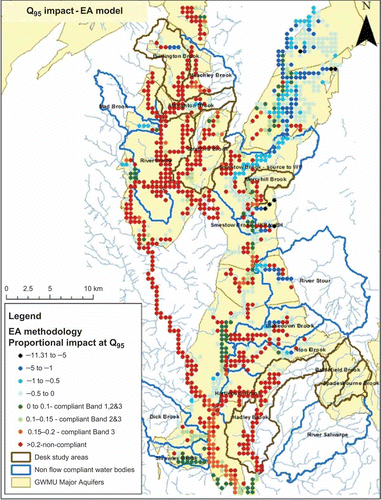
shows the results of applying the hydro-ecological relationship in Bradley et al. (Citation2013) to the recent actual abstraction scenario from the WMW model. Comparison with the equivalent figure applying the relevant EFIs () suggests that the locally derived hydro-ecological relationship implies that there are fewer reaches in which the macro-invertebrates were likely to be negatively impacted by abstraction than appeared to be the case using the national screening EFIs as criteria. In general, the reaches where macro-invertebrates were considered to be at risk of being negatively impacted by groundwater abstraction using the former approach were restricted to small headwater streams.
Fig. 3 Assessment of likely ecological status of streams in WMW model area using local hydro-ecological relationship at Q75 (Bradley et al. Citation2013). Colour coding of green, yellow and red is the same as categories described in the text. Blue areas show reaches where the flow under the recent actual scenario is greater than the naturalized flow; these increased flows are predominantly due to sewage discharges.
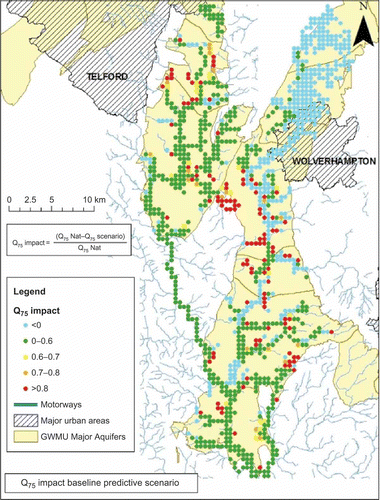
Fig. 4 Compliance of flows in streams in WMW model area with WFD EFIs for Q95 flows.
This has been confirmed by comparison of an independent set of LIFE data for these streams (collected by the Environment Agency) with the effect of abstraction on river flows calculated by the groundwater models (). This retrospective check with independent data from similar sites within the study area provides a powerful validation of the hydro-ecological relationships developed by Bradley et al. (Citation2013).
Fig. 5 Hydro-ecology validation plot for the WMW area. Data for AMP4 sites (Bradley et al. Citation2013) and historical data from Environment Agency sites (flow impacts derived from groundwater model). The mean LIFE O/E value at each site is plotted. The trend line, its 95% confidence and prediction intervals are shown together with 0.94 LIFE O/E.
Looking at , there is clearly a fair amount of variation in the y-axes (LIFE Observed/Expected), which may be related to temporal climatic variation and other environmental factors. This may merit more detailed local investigation of other pressures, but does not alter the overall conclusions with respect to groundwater abstraction stress.
Comparison of different abstraction scenarios (local)
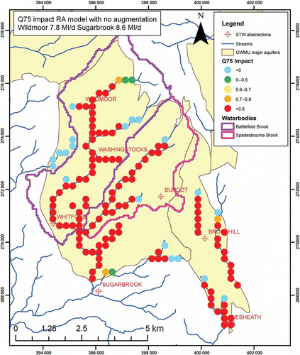
Having established a methodology that effectively calibrates the groundwater model results against ecological status, it is then possible to interrogate the results from any predictive model scenarios and assess the implications of any proposed change in abstraction directly in terms of the implied risk to the local macro-invertebrate communities. An example of this is shown in and , which present the inferred ecological status of the streams around Bromsgrove as a result of two different abstraction scenarios: In the scenario presented on , the Wildmoor groundwater abstractions have been switched off. The length of river over which ecological status would be expected to improve as a result of this change can be assessed directly from these plots.
Fig. 6 Hydro-ecological assessment of streams on Bromsgrove aquifer for the recent actual scenario.
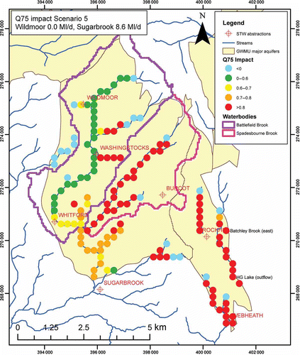
Fig. 7 Hydro-ecological assessment of streams on Bromsgrove aquifer for the recent actual scenario, except Wildmoor PWS is switched off.
Quantification of proportion of wastewater discharge in streams at low flows
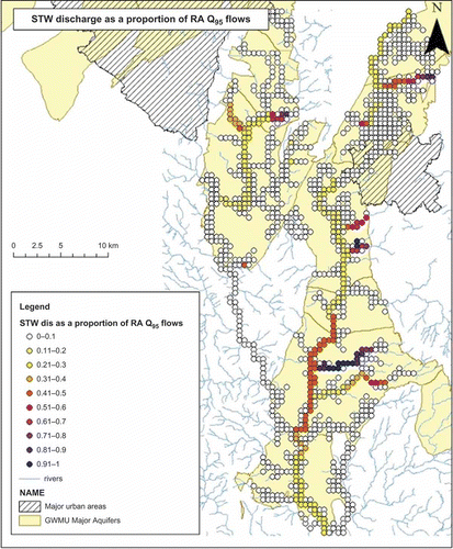
The groundwater models can also be used to quantify the amount of sewage treatment discharge in the streams under different flow scenarios as shown in . In this case, the discharges from the treatment works (which are included in the 4R recharge–runoff model) have been switched off and the change in flows downstream has been used as a measure of the contribution of the discharges to flow. It can be seen that some streams have a significant component of wastewater discharge, and it can be anticipated that, in these streams, water quality may be a confounding influence on LIFE scores.
Fig. 8 Proportion of sewage treatment works (STW) discharge in streams at Q95.
DISCUSSION
Applications and potential limitations of the methodology
The discipline of hydro-ecology (and ecohydrology) is barely a decade old (Wood et al. Citation2007), and yet it is increasingly called upon to inform major decisions about the allocation of the world’s most precious natural resource. As water resource management increasingly considers the environment, it would benefit from quantitative predictions of the ecological effects of river flow alterations. Few studies, however, provide sufficient information to support the development of regional environmental flow frameworks, such as ELOHA (Poff and Zimmerman Citation2010, Carlisle et al. Citation2012). This study is currently unique in that it uses quantitative relationships between ecology and flow alterations (Bradley et al. Citation2013) and applies them in a method that is appropriate to inform regional water management decisions.
There has been extensive development and application of environmental flow methods globally (Tharme Citation2003, Acreman and Dunbar Citation2004, Dyson et al. Citation2008). Most of these methods use relationships between biota and river flows to infer impacts from abstraction or flow regulation in the setting of environmental flow standards (e.g. Bovee et al. Citation1998, Extence et al. Citation1999, Dunbar et al. Citation2010). These methods fall short in that they do not incorporate quantitative measures of hydrological alteration from reference conditions and, ultimately, rely on expert opinion to set environmental flow standards, such as the Environment Agency (UK) EFIs (Acreman et al. Citation2008).
Consistent with the ELOHA framework, the method presented here uses quantitative measures of deviation from reference conditions for both hydrology and ecology (Poff et al. Citation2010). The scale at which this method is applied is designed to bridge the gap between existing methods that are either highly detailed and site-specific (such as Physical Habitat Simulation; Bovee et al. Citation1998) or national-scale “rules of thumb” (such as EFIs; Acreman et al. Citation2008) that have insufficient certainty to apply to investigation sites and are therefore conservative and used as screening tools to trigger further investigation using a method such as the one presented here.
A major advantage of the method presented here, and a feature that is consistent with ELOHA, is that it can be applied along river reaches between existing assessment points, at the scale of the groundwater model analysis nodes (Poff et al. Citation2010). This will help to optimize resources by focusing sampling to areas of uncertainty and provide an assessment of possible ecological impacts of abstraction throughout entire river water bodies. In this way, the method overcomes the problems of relying on sample-specific impact assessment and quantifies the length of river that will benefit from any mitigation measures.
There are several limitations of this method that need to be considered:
– First, it is a regional model based on data from streams originating from Permo-Triassic Sandstone aquifers in the midlands of England. While the methodological approach might have more wide application, the underlying models presented in this study do not.
– Second, the underlying hydro-ecological relationships (Bradley et al. Citation2013) were calibrated on unpolluted streams with similar physical character and on reaches with no major morphological alterations. The relationship between river flow variability and ecology is dependent on the geomorphic context of the river channel (Poff et al. Citation2006) and especially the degree of artificial modification (Dunbar et al. Citation2010). This method cannot be applied with confidence directly to river reaches that are artificially modified or have poor water quality. However, the model that is independent of major environment pressures other than groundwater abstraction has a useful application in water company investigations where the impact of abstraction in the absence of other pressures needs to be established. Further work is underway to quantify the relationships between LIFE and the hydrological effect of groundwater abstraction under different levels of morphological alteration.
– Third, LIFE scores reflect the physical quality of river reaches for macro-invertebrates; they do not describe the quantity of aquatic habitat for macro-invertebrates (SNIFFER Citation2012). The standard sampling method prescribes a fixed sampling time, regardless of the size of the wetted habitat. The implications of this are that river habitats that shrink due to abstraction and retain their physical character in miniature will not be reflected in LIFE scores. Quantitative sampling of separate and visually distinct in-stream habitats, combined with mapping of habitat areas (Armitage and Pardo Citation1995), should be considered in future assessments of the impact of flow alterations on macro-invertebrates to account for habitat quantity. Also, while macro-invertebrates are widely used biological indicators of environmental perturbations, this method cannot be directly applied to impact assessments of other organisms, such as fish.
– Fourth, the measure of ecological impact on the underlying model relies on the prediction of a reference condition for macro-invertebrates in the absence of flow alterations owing to groundwater abstraction. The River Invertebrate Prediction and Classification System (RIVPACS) model that provides these predictions was originally designed for assessing the effects of water pollution, so the variables that are measured on site to generate the predictions are not all independent of the effects of abstraction (Wright et al. Citation2000). Work is currently underway to develop pressure-independent RIVPACS models for more reliable application to water resource investigations (SNIFFER Citation2011). Also, the reference sites used in the model might not all be independent of flow alterations. Ongoing work to improve RIVPACS for water resource investigations has identified 42 reference sites that should be excluded from the model (SNIFFER Citation2008).
These limitations associated with the RIVPACS model need to be tested in every individual water resource application. Bradley et al. (Citation2013) examined the community response of macro-invertebrate taxa to the effect of abstraction in order to test the validity of the RIVPACS-based hydro-ecology model described in this study. The response of the individual macro-invertebrate taxa to the effect of abstraction was consistent with the RIVPACS-based model, giving confidence to the methods presented here (Bradley et al. Citation2013). Furthermore, the results presented in Bradley et al. (Citation2013) were consistent with other studies on the impacts of abstraction on macro-invertebrates that showed that impacts were most obvious with substantial dewatering (Armitage and Petts 1992, Bickerton et al. 1993, Castella et al. Citation1995, Chessman et al. Citation2011).
Implications for water resource management in the area
EFIs are used by the Environment Agency as national flow screening thresholds. Where flows are below the EFIs, this indicates reaches in which flow pressure may compromise WFD ecological status. The values set for EFIs make this a conservative approach, as would be expected for a national screening system.
Where flows are currently assessed as being below the relevant EFI, this triggers further investigations to confirm ecological impact. For sites flagged up by this screening exercise, it is possible that site-specific flow and ecology data may show that abstraction effects on streamflows and ecology are acceptable and do not contribute to the failure of Good Ecological Status under the WFD.
The flow reductions required to reduce abstraction stress to acceptable levels (as assessed by the adoption of locally based hydro-ecologically derived flow targets) are therefore, in this case, substantially lower than those implied by adoption of the EFIs. For the Worcestershire Middle Severn Sandstone groundwater body (effectively the area covered by the WMW and Bromsgrove models), the difference between applying the site-specific targets and the nationally applied EFIs is ~80 ML/d (0.93 m3/s); that is ~20 ML/d or 0.23 m3/s reduction is required using local hydro-ecological targets as opposed to ~100 ML/d (1.2 m3/s) using EFIs.
Given that re-locating 1 ML/d of abstraction is typically costed at £1–3 millionFootnote5, the cost implications of these findings are significant and provide a clear justification for carrying out such local investigations. In addition, the ability to use the groundwater model results to quantify the reaches that might benefit from different abstraction regimes provides useful information for the cost-benefit analysis that will be used to judge the cost effectiveness of the options considered to remediate any impacts of over-abstraction.
Assessing the significance of anthropogenic discharges
As discussed above, several of the streams in the area that are affected by groundwater abstraction have the impact on flow effectively mitigated by discharge of treated sewage effluent. While this will benefit flows, the overall effect on stream ecology will be determined by the amount of dilution of the discharge and the level of treatment applied. This gives an indication of reaches in which the attainment of Good status may be limited by water quality rather than flow.
In some of the sites being investigated, STWL is considering closing small, inefficient or outdated sewage treatment works. The resultant relocation of this discharge of water may have significant effects on local streamflows and quality. However, this process is largely managed and regulated through different teams in STWL and the Environment Agency, and so integrating this into the overall water resource management system is a challenge.
Similarly, while reduction in STWL’s mains leakage rates—down from 584 ML/d (6.8 m3/s) in 1996/97 to 474 ML/d (5.5 m3/s) in 2011/12—has reduced abstraction demand, it has also reduced the return of almost a quarter of this abstracted water to streams in urban areas (where most of the leakage occurs). In some of the areas being investigated (e.g. Bromsgrove and Coventry), main leakage appears to make a significant contribution to the local water balance, and reductions in urban streamflows in these areas will potentially be an unforeseen side effect of increased efficiencies in urban water use.
Ongoing work
The success of the analysis outlined above in quickly giving STWL and the Environment Agency confidence in the likely status of rivers across the area with respect to abstraction stress has helped to focus monitoring in the current investigations on sites at which there was the greatest level of uncertainty about the likely degree of abstraction stress; that is the screening analysis identified sites that were very likely to be stressed, (and thus required only validation sampling to confirm this) and also screened out some sites at which stress was unlikely and further investigation was clearly not required. The STWL is now carrying out a major programme of hydro-ecological field investigations (flow, groundwater levels and ecology surveys) at the sites where the level of abstraction stress was uncertain so as to quantify the level of abstraction stress more accurately and, where this is significant, to help identify the flows required to reduce stress to an acceptable level. These new data will allow the results of this modelling study to be validated. These investigations include investigation of fish as well as macro-invertebrates and also assessment of potentially confounding effects (e.g. water quality, sediment, etc.).
In parallel, the Environment Agency has licensed STWL to use the regional groundwater models that it has developed to support these investigations. In some cases STWL has carried out further localized refinement of these models so that they are able to provide a more robust assessment of the likely implications of abstraction in the catchments being studied. The results of these investigations will be fed into STWL’s 25 year Water Resources Management Plan, which is currently under preparation.
CONCLUSIONS
Methods for managing water resources that are based on quantitative relationships between degrees of river flow alteration and ecological impact are scarce and, as a result, most environmental flow management relies on expert opinion and is characterized by high uncertainty. This is increasingly unacceptable given the global demands for water, climate change and the potentially large financial investments that will be needed to protect valuable ecosystems and services. In this article, we have presented an approach for integrating local hydro-ecological relationships with the results of groundwater models that have been used to quantify reductions in streamflow as a result of groundwater abstraction. This type of approach has the potential to provide regulators and water users with a powerful tool for assessing the potential effects of different water resource options on ecological status as defined by the macro-invertebrate LIFE index.
This approach implies that, for the streams investigated, the WFD EFIs are distinctly conservative, as required for a national screening tool. The flows implied by the EFIs should not be unquestioningly translated into flow targets without a more detailed assessment of local hydro-ecological conditions. Use of EFIs as flow targets to assess the scale of reductions in groundwater abstraction that would be required to ensure that the hydro-morphology of these streams supports Good Ecological Status/Potential leads to very substantial potential reductions in abstraction being flagged up to water companies (e.g. as in the Environment Agency’s “Case for change—current and future water availability”), whereas more detailed studies have in this case demonstrated that the scale of abstraction reduction required is much less than this.
Acknowledgements
The investigations on which this article is based were commissioned by Severn Trent Water Ltd, and the company’s support and permission to publish this is gratefully acknowledged. The groundwater models used for assessing flow impacts were developed by the Environment Agency and were run under license for Severn Trent Water Ltd. The authors thank Mike Dunbar and an anonymous reviewer for valuable and constructive comments on the manuscript.
Notes
1 Expected LIFE scores are calculated using the River Invertebrate Prediction and Classification System (RIVPACS).
2 Note that the end date for each of the models is slightly different as they were developed sequentially. The period used for calculating the flow statistics presented in this article varies slightly between models but is generally around 30 years. This is unlikely to make a significant difference to the results, especially as the key comparator is between the naturalized and recent actual runs for each model, which use identical climate sequences/periods.
3 The naturalized models start from naturalized groundwater levels and are run sequentially until equilibration is achieved. However, the recent actual models usually start from present day conditions so may not be fully equilibrated at the beginning of the model run.
4 Note that EFIs have also been set for other flow percentiles (e.g. Q30, Q50, Q70) with more flow reduction being allowed at higher flows. However, as noted above, groundwater abstraction affects flows at a fairly constant magnitude across the flow spectrum. As a result, the Q95 EFI is the most conservative with respect to groundwater abstraction and effectively controls the screening assessment results.
5 In http://nora.nerc.ac.uk/9807/1/Bearing_the_cost_CIWEM.pdf, the British Geological Society quotes a mean figure of £1.3 million per ML/d.
6 Days in a year multiplied by 1000.
REFERENCES
- Acreman, M., et al., 2008. Developing environmental standards for abstractions from UK rivers to implement the EU Water Framework Directive. Hydrological Sciences, 53, 1105–1120.
- Acreman, M. and Dunbar, M.J. 2004. Defining environmental river flow requirements—a review. Hydrology and Earth System Sciences, 8, 861–876.
- Armitage, P.D. and Pardo, I. 1995. Impact assessment of regulation at the reach level using mesohabitat information. Regulated Rivers: Research & Management, 10, 147–158.
- Armitage, P.D. and Petts, G.E. 1992. Biotic score and prediction to assess the effects of water abstractions on river macroinvertebrates for conservation purposes. Aquatic Conservation: Marine and Freshwater Ecosystems, 2, 1–17.
- Bickerton, M.A., et al., 1993. Assessing the ecological effects of groundwater abstraction in chalk streams: three examples from eastern England. Regulated Rivers: Research and Management, 8, 121–134.
- Bovee, K.D., et al., 1998. Stream habitat analysis using the instream flow incremental methodology. Washington, DC: US Geological Survey, Biological Resources Division. Information and Technology Report USGS/BRD–1998–0004.
- Bradley, D.C., et al., 2013. Establishing hydroecological relationships to manage the impacts of groundwater abstraction. Water and Environment Journal [online]. Available from: http://authorservices.wiley.com/bauthor/onlineLibraryTPS.asp? doi: 10.1111/wej.12018 [Accessed 24 January 2014].
- Brown, L. and Hulme, P. 2001. Environment agency framework for groundwater resources conceptual and numerical modelling. Environment Agency R&D Technical Report W214.
- Carlisle, D.M., Nelson, S.M., and Eng, K. 2012. Macroinvertebrate community condition associated with the severity of streamflow alteration. River Research and Applications. Published online in Wiley Online Library. doi:10.1002/rra.26.26
- Castella, E., et al., 1995. The effects of water abstractions in invertebrate communities in UK streams. Hydrobiologia, 308, 167–182.
- Chessman, B.C., Royal, M.J., and Muschal, M. 2011. The challenge of monitoring impacts of water abstractions on macroinvertebrates assemblages in unregulated streams. River Research and Applications, 27, 76–86.
- Dunbar, M.J., et al., 2010. River discharge and local-scale physical habitat influence macroinvertebrate LIFE scores. Freshwater Biology, 55, 226–242.
- Dyson, M., Bergkamp, G., and Scanlon, J., eds., 2008. Flow—the essentials of environmental flows. 2nd ed. Gland: IUCN.
- Extence, C.A., Balbi, D.M., and Chadd, R.P. 1999. River flow indexing using British Benthic Macroinvertebrates: a framework for setting hydroecological objectives. Regulated Rivers Research & Management, 15, 543–574.
- Heathcote, J.A., Lewis, R.T., and Soley, R.W.N. 2004. Rainfall routing to runoff and recharge for regional groundwater resource models. Quarterly Journal of Engineering Geology and Hydrogeology, 37, 113–130.
- Hulme, P., Fletcher, S., and Brown, L. 2002. Incorporation of groundwater modelling in the sustainable management of groundwater resources. In: K.M. Hiscock, M.O. Rivett and R.M. Davison, eds. Sustainable groundwater development, London: Geological Society, Special Publication 193, 83–90.
- King, J., Brown, C., and Sabet, H. 2003. A scenario-based holistic approach to environmental flow assessments for rivers. River Research. Applications, 19, 619–639.
- McDonald, M.G. and Harbaugh, A.W. 1988. A modular three dimensional finite difference ground-water flow model. US Geological Survey Techniques of Water Resources Investigations Report, 06–A1. United States Geological Survey. Available from: http://water.usgs.gov/ogw/MODFLOW_list_of_reports.html [Accessed 1 November 2013] .
- Merrit, D.M. and Poff, N.L. 2010. Shifting dominance of riparian Populus and Tamarix along gradients of flow alteration in western North American rivers. Ecological Applications, 20, 135–152.
- Monk, W.A., et al., 2008. Macroinvertebrate community response to inter-annual and regional river flow dynamics. River Research and Applications, 24, 988–1001.
- Poff, N.L., et al., 2010. The ecological limits of hydrological alteration (ELOHA): a new framework for developing regional environmental flow standards. Freshwater Biology, 55, 147–170.
- Poff, N. L., et al., 2006. Placing global streamflow variability in geographic and geomorphic contexts. River Research and Applications, 22,149–166.
- Poff, N.L. and Zimmerman, J.K.H. 2010. Ecological responses to altered flow regimes: a literature review to inform the science and management of environmental flows. Freshwater Biology, 55, 194–205.
- SNIFFER, 2008. River invertebrate classification tool. SNIFFER Research Report WFD72C. SNIFFER. Available from: http://nora.nerc.ac.uk/3800/ [Accessed 1 November 2013].
- SNIFFER, 2011. Enhancement of the river invertebrate classification tool. SNIFFER Research Report WFD119. SNIFFER. Available from: http://nora.nerc.ac.uk/17989/ [Accessed 1 November 2013].
- SNIFFER, 2012. Ecological indicators of the severe effects of abstraction and flow regulation; and optimising flows from impoundments. SNIFFER Research Report WFD 21D. SNIFFER. Available from: http://www.wfduk.org/search/content/optimisation%20of%20flow%20releases [Accessed 14 January 2014].
- Shepley, M.G. and Soley, R. 2009. East midlands yorkshire sherwood sandstone groundwater modelling project – task 3. Final report. Version 1. Report for the Environment Agency of England and Wales. Rotherham: Environment Agency.
- Shepley, M.G. and Streetly, M. 2007. The estimation of “Natural” summer outflows from the Permo-Triassic Sandstone Aquifer, UK. Quarterly Journal of Engineering Geology and Hydrogeology, 40, 213–227.
- Soley, R.W.N., et al., 2001. West midlands permo-triassic sandstone water resources study. Report for the Environment Agency of England and Wales, Report No. rr880i2. Rotherham: Environment Agency.
- Streetly, H. and Shepley, M.G. 2010. Bromsgrove Sherwood Sandstone aquifer investigation. Report for the Environment Agency of England and Wales. Rotherham: Environment Agency.
- Streetly, M.J. and Shepley, M.G. 2005. Final report, East Shropshire Permo-Triassic sandstone groundwater modelling project—task 8. Report of the Environment Agency of England and Wales. Rotherham: Environment Agency.
- Tharme, R.E. 2003. A global perspective on environmental flow assessment: emerging trends in the development and application of environmental flow methodologies for rivers. River Research and Applications, 19, 397–441.
- UKTAG, 2008. UK environmental standards and conditions (Phase 1), Final Report (Sr1—2006), UK Technical Advisory Group on the Water Framework Directive [online]. Available from: http://www.wfduk.org/resources%20/uk-environmental-standards-and-conditions-report-phase-1.
- Whiteman, M.I., et al., 2012. Start, development and status of regulator-led national groundwater resources modelling programme in England & Wales. In: M.G. Shepley, et al., eds. Groundwater resources modelling: a case study from the UK. London: Geological Society of London Special Publication, 364.
- Wood, P.J., Hannah, D.M., and Sadler, J.P., eds., 2007. Hydroecology and ecohydrology: past, present and future. Chichester: Wiley and Sons.
- Wright, J.F., Sutcliffe, D.W., and Furse, M.T. 2000. Assessing the biological quality of freshwaters: RIVPACS and other techniques. Ambleside: Freshwater Biological Association.
APPENDIX
COMPARISON OF MONTHLY AND DAILY MODEL RESULTS
Comparison of monthly vs daily flow duration curves
As discussed, the results of the groundwater models used in these investigations are typically calculated for monthly stress periods, and therefore, comparisons with daily flow data need to be treated with caution. To demonstrate this, the flow duration curves (FDC) derived from daily and monthly observed data for the Battlefield Brook in Bromsgrove are shown in Fig. A1. The monthly FDC is less “flashy” because the extreme high and low daily flows have been averaged over a monthly period. For larger streams and flashier streams, such as those with areas of Mercia Mudstone or Carboniferous deposits in their catchment, the difference between monthly and daily FDCs will be proportionally greater.
Correction for monthly time steps
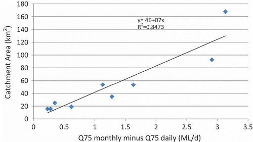
Daily data for nine water courses with permanent gauges, whose catchments are predominantly on the Permo-Triassic Sandstone, have been analysed to determine the effect of using monthly flows the groundwater model to determine Q75. The results are summarized in .
The difference between Q75 values derived from monthly averages and daily data is correlated reasonably well with the catchment size, as shown in Fig. A2. If the difference between Q75 values (in ML/d) is converted to an equivalent recharge rate over the catchment, then these rates vary from 5 to 13 mm/year.
Therefore, the difference between monthly and daily Q75 values can be estimated from the catchment size, and correction can be made to the groundwater model Q75 to account for the fact that it is using monthly average flows. As a worst case, we have used a value of 15 mm/year across the catchment to calculate the reduction in Q75 for each of the water bodies as follows:
where
andFootnote
Daily WMW model
The effects of using monthly model outputs on the results have also been investigated by running the WMW naturalized model with daily time steps for the period January 1990–July 2006. The results were checked by comparing the groundwater level outputs with those from the original WMW model. At the end of the model run, there was a maximum difference of 0.04 m at the observation wells for the final stress period, which was judged to be insignificant given the overall range in water level fluctuation (5–20 m) in most observation boreholes. The difference in Q75 flows between the daily and monthly models is shown in .
The impact of groundwater abstractions on flows (i.e. the difference in flows between the monthly naturalized and RA models) is expected to be similar for both the daily and monthly models, as abstractions only impact on base flows and stream leakage, which do not fluctuate on a daily timescale. Therefore, the spatial distribution of proportional impact at Q75 has been calculated, using the results from the naturalized daily model, as follows:
Note that generally the Q75 from the daily model is less than the Q75 from the monthly model, due to the simulation of flashier flows. However, there may be areas where the daily model Q75 flows are higher because the stream leakage is reduced in the daily model compared with the monthly model (water not available for leakage on every day in the month).
The use of the daily naturalized model makes a small difference to the proportional impact at Q75 calculated using the empirical monthly to daily approach (corrected for catchment area) at the waterbody outflow points, as summarized in . However, the difference was not large enough to change the attribution of impact category in each catchment in most cases.
Table A1 Difference between daily and monthly flow duration curves.
Table A2 Summary of Q75 impacts for surface waterbodies. Red shading, proportional impact at Q75 > 0.8; yellow, proportional impact at Q75 between 0.6 and 0.8.
Fig. A1 Monthly vs daily flow duration curves for the Battlefield Brook at Sanders Park.
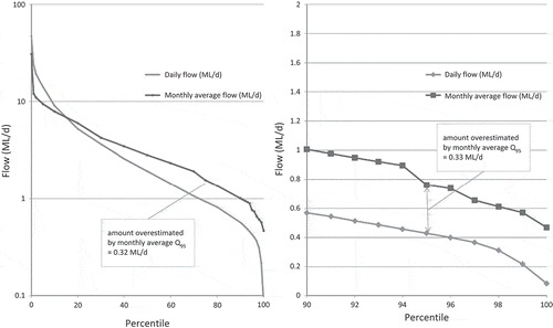
Fig. A2 Correlation of Q75 monthly minus Q75 daily with catchment size.