
Abstract
This article identifies and analyzes the effects of human pressures on the river systems, landscape, flow regime, and water quality in the Bucharest region, the largest urbanized area in Romania. The analyses focused on four streams crossing the Bucharest region, namely the Dâmboviţa, Colentina, Argeş, and Sabar rivers. Our approach relied especially on three types of information: (1) spatial data; (2) hydrological data sets; and (3) water quality data. We made a diachronic analysis of the available maps and ran classic statistical analysis of the data sets, as well as trend analysis. At the same time, we compared the flows in natural (reconstituted) and modified (current) regimes. The results showed that the stream system and its associated landscapes have considerably changed due to several engineering works (reservoirs, dams, channelization works, diversion canals, water intakes, etc.). Under these circumstances, the flow regime suffered changes that differed among the rivers. Thus, the multiannual discharges of the Argeş and Dâmboviţa rivers did not exhibit significant changes, but only mitigated the monthly discharge variability. In the case of Sabar and Colentina, a significant increase of the annual and monthly discharges was identified, due to the water transferred from the neighboring rivers. Water quality worsened, especially on the lower courses of the Dâmboviţa and Argeş rivers, degrading the states and health of the aquatic ecosystems in the study region.
Introduction
Human pressure on rivers is increasing all over the world, threatening the water security, and the aquatic ecosystem health. The problem is particularly acute in urbanized regions because the cities, due to their specific features, are a major factor influencing the water cycle, in general, and the river systems, in particular. Over the last two centuries, urbanization has caused important changes in watershed drainage system and hydrology: the rivers crossing city areas have been exploited for water supply and have been regulated, channelized, dammed, diverted, and buried (Ceola et al. Citation2015). As natural receptacles for urban wastewaters, the rivers undergo continuous qualitative alterations, which affect the related ecosystems' health or their ecological integrity (Oliveira and Cortes Citation2006). It is therefore obvious that in urbanized areas river flow regime, water chemistry, and quality are modified, affecting the ecosystem structure, functions, and services (Su et al. Citation2012, Kaushal et al. Citation2015). The urbanization has led to an “urban stream syndrome” having as symptoms a flashier hydrograph, elevated concentrations of nutrients and contaminants, modified channel morphology, and reduced biotic richness (Walsh et al. Citation2005).
Many previous works have referred to the relation between rivers and urban development as well as to the effects of urbanization on landscapes and stream systems. Of these, the following are worth mentioning: Leopold (Citation1968), Paul and Meyer (Citation2001), Miltner et al. (Citation2004), Meyer et al. (Citation2005), Walsh et al. (Citation2005), Chin (Citation2006), Barles (Citation2007), Kennedy et al. (Citation2007), Grimm et al. (Citation2008), O'Driscoll et al. (Citation2010), McDonald et al. (Citation2011a, Citation2011b, Citation2013, Citation2014), Pickett et al. (Citation2011), Haidvogl et al. (Citation2013), Hohensinner et al. (Citation2013a, Citation2013b), Kaushal et al. (Citation2015).
This article investigates the case of Bucharest, the capital of Romania, the country's most representative example in terms of urban effects on river systems. It aims to provide a synthetic portrait of human interventions on the main rivers crossing the Bucharest region and to assess some of their quantitative and qualitative effects on these watercourses. The paper focuses on two main issues: (1) the major human pressures responsible for hydrographic, hydrological, and qualitative changes in the rivers (engineering works; water abstraction for various needs; wastewater discharge) and (2) the effects of urbanization on stream network, landscape, flow regime, and water quality.
The paper supplements and updates the information generated by previous works and studies, regarding the quantitative and qualitative characteristics of water resources in the Bucharest region, on the one hand, and their management, on the other hand. The most important such studies are the following: Georgescu et al. (Citation1966), Giurescu (Citation1967), Iordan (Citation1977), Pişota and Moissiu (Citation1977), Solacolu and Ceachir (Citation1981), Ionescu et al. (Citation1988), Popescu and Lăzărescu (Citation1988), Solacolu (Citation1988), Zaharia et al. (Citation1997), Cocoş (Citation1999), Zaharia and Cocoş (Citation1999), Cocoş (Citation2006), Soare‐Bratosin (Citation2015), Soare (Citation2015a, Citation2015b). Likewise, the Watershed management plan of Argeş—Vedea Water District (NARW Citation2011, MEWF and NARW Citation2016), the Watershed flood defense plan in Argeş—Vedea Water Branch (NARW Citation2015a), the County flood defense plans (NARW Citation2015b), and the annual environmental state reports in Bucharest City (made by the National Environmental Protection Agency) include a rich body of information concerning the watercourses in the Bucharest region and their management.
This article synthesizes and integrates information from the aforementioned studies, but at the same time delivers certain original contributions concerning the following topics: (1) diachronic analysis of cartographic documents and images, which allowed us to highlight the changes in the stream network and in the landscape associated with the rivers crossing Bucharest region; (2) comparative analysis of the average annual and monthly discharges of the main rivers in the study area, under natural (reconstituted) and modified flow regimes, analysis based on which we identified and quantified the changes induced by human pressures; (3) trend analysis of hydrological data sets variability; (4) spatial analyses regarding the ecological state of the studied rivers. The results allow a better understanding of the effects of the urbanization on watercourses, and generally of the human‐coupled aquatic ecosystems functioning in the investigated area.
Study area and the main morphometric and hydrologic features of the rivers crossing the Bucharest region
Bucharest, capital of Romania since 1659, is the most important city in terms of the number of residents and its various functions (economic, political, cultural, financial, etc.). First mentioned in documentary sources in the 15th century (1459), the settlement has developed continuously, becoming the greatest urban area in the country. At present, Bucharest stretches over 238 km2 (10% of the country's area) and shelters a number of 2,140,816 people (on 1 July 2013), which accounts for about 10% of Romania's population, with a density of 8,895 inhabitants per square kilometer (according to RSDBM Citation2014).
Bucharest is located in the southeastern part of the country, within the Argeş River watershed, in a region belonging to the Romanian Plain, where drainage density is high and elevations are of 60–90 m a.s.l. (Fig. 1). Its territory is crossed on a northwest–southeast direction by the Dâmboviţa and Colentina rivers, which have large floodplains and terraces where the city has found good conditions for its sprawl. However, because of this location in a floodplain area, Bucharest has high flood risk susceptibility. Consequently, in order to avoid such events, since the 18th century, the authorities have imposed a number of protection measures and have developed engineering techniques.
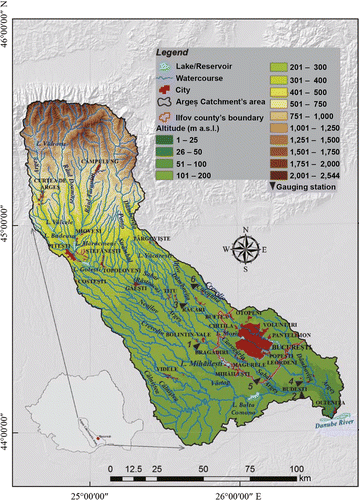
In the vicinity of Bucharest, there are other rivers as well: Argeş, Sabar, Ciorogârla, Ilfov, Ialomiţa, and Pasărea. Over time, all these were engineered and included in a complex management scheme, aimed at meeting the water demands of the Bucharest urban area, as well as at protecting the city against flooding. The present analysis focuses on the Dâmboviţa, Colentina, Argeş, and Sabar rivers. Their main morphometric and hydrological features are given in Tables and .
Table 1. Main morphometric features of the rivers crossing the Bucharest City region
Table 2. Main hydrological features of the rivers crossing the Bucharest City region
The city's development and the high concentration of people and socioeconomic activities have increased water consumption for various uses. In 2013, the amount of drinking water supply was 381 million m3, of which 213 million m3 for domestic use. In the same year, the wastewater volumes released in Bucharest area (Bucharest City and adjoining county Ilfov) were about 370 million m3 (RSDBM Citation2014).
Materials and Methods
The paper relies on several types of data: (1) information extracted from scientific literature; (2) spatial information provided by cartographic documents and images from various periods; (3) hydrological data sets concerning the average monthly and annual discharges recorded on the main rivers in the region (Argeş, Dâmboviţa, Colentina, and Sabar), which were provided by the National Administration “Romanian Waters”—the Argeş‐Vedea Water Branch (NARW‐AVWB); and (4) data on water quality provided by the NARW‐AVWB. Table shows the data/documents used and their characteristics.
Table 3. The data and documents used and their characteristics
In terms of methods, the paper is based particularly on the following: (1) bibliographic and cartographic research; (2) diachronic analysis of cartographic documents and satellite images; (3) statistical analyses of hydrological data sets (classical statistical parameters); (4) trend analysis in hydrological data sets variability using Mann‐Kendall statistical test; and (5) spatial analysis of the ecological state of the studied rivers.
The effects of the engineering works on river flow were highlighted based on the comparative analysis between the monthly and annual average discharges in natural flow regime (Qn), on the one hand, and the modified regime (Qm), on the other hand, as resulted from the data provided by the NARW‐AVWB. The periods for the selected gauging stations are mentioned in Table and they are depending on data availability.
The natural flow regime was reconstituted by the NARW‐AVWB, based on the various water uses. To quantify the difference between the natural/reconstituted (Qn) and the modified/current discharges (Qm), we computed the change rate (DQ) using the equation:
1
The flow variability of the two types of regimes (natural and modified) was highlighted based on the variation coefficients (Cv) of the annual and monthly average discharges.
Results
The main anthropogenic pressures on the rivers in the Bucharest City region
Just as in all urban areas, the rivers in the Bucharest City region are subjected to quantitative and qualitative pressures, which are mainly represented by engineering techniques, water abstractions, and wastewater discharges. The key objectives of all these are related to the aquatic ecosystem services: (1) water supply for various uses; (2) flood defense; (3) sewage collection; (4) recreation (swimming pools, wetlands, fountains), etc.
The main engineering techniques
The engineering works in the Bucharest region are mainly represented by dams, reservoirs, channelization and flow regulation works, interbasin water transfers and water intakes. These works are an integral part of the Argeş watershed management scheme, which includes the study area. The region shows a dense network of dams and reservoirs, as well as diversion and water provision canals (Fig. 2). The first significant engineering works started in the 18th century and, as the socioeconomic and demographic importance of the city grew, they have developed accordingly.
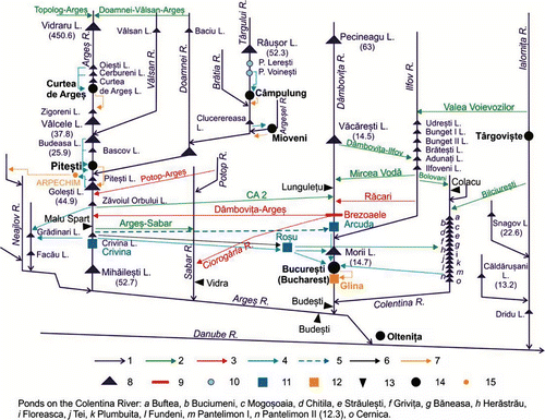
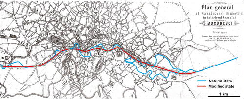
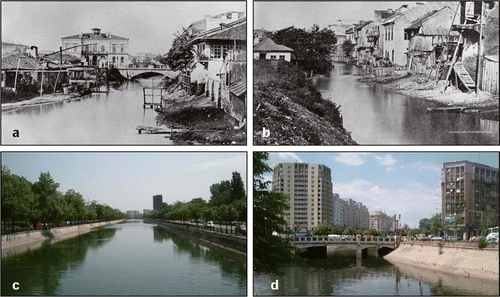
Dâmboviţa River originates in the Carpathian area, at 1,800 m a.s.l., and flows into the Argeş downstream of Bucharest (Fig. 1). Its total length (L) is 286 km and the area of its watershed (A) is 2,824 km2 (Table ). The average multiannual discharge recorded at Budeşti gauging station (upstream of the confluence with the Argeş River) is about 22 m3/s (Table ). Bucharest is located in the lower course of the Dâmboviţa, which crosses it on a northwest–southeast direction on about 24 km. The implementation of engineering works on this river started in 1774, when following a sequence of catastrophic flooding, Prince Alexandru Ipsilanti ordered the creation of a diversion canal upstream of Bucharest (between Lunguleţu and Brezoaele). This was meant to transfer, during high water and flood periods, discharges from Dâmboviţa River to the Sabar River, which flows to the west, through the Ciorogârla River (Georgescu et al. Citation1966). After the damaging floods that occurred between 1862 and 1865 in Bucharest region, the authorities built a diversion canal at Arcuda. Subsequently, the Dâmboviţa River's training has become more and more complex, including: 13 canals for water transfer (10 of them in the Bucharest City area), which link the river to the other streams in the region, channelization works, dams, and reservoirs. At the end of the 19th century (1880–1900), Dâmboviţa's course in the Bucharest area underwent extensive channelization and regulation works (Fig. 3). Consequently, its length within the city was reduced by about one kilometer. By the end of the 20th century, three reservoirs were completed on the Dâmbovi-a River, namely: Pecineagu, with a volume (W) of 63 million m3, in the upper (mountain) sector; Văcăreşti (W = 14.5 million m3), in the middle (hilly) sector; and Lacul Morii (W = 14.7 million m3) within the Bucharest City (the volumes correspond to the normal designed stage and are according to NARW Citation2015a).
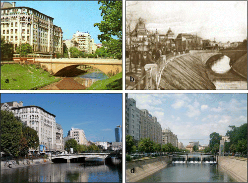
During the period 1985–1989, the authorities implemented the “Complex Management Scheme of the Dâmboviţa River in Bucharest,” which aimed to: regulate Dâmboviţa's flow, protect the city against flooding, collect and remove wastewaters and storm waters, as well as establish a number of recreation sites for the city's residents (Solacolu Citation1988). The engineering works mainly consisted of three elements: (1) Lacul Morii reservoir (A = 220 ha; W = 14.7 million m3) lying upstream the Ciurel dam (15 m high); (2) the channelization of the Dâmboviţa River within the city (downstream of the Ciurel dam), on a length of 17 km, including 11 weirs which separated slackwater pools; and (3) the wastewater drain situated under the Dâmboviţa's canal. Unlike the channelization accomplished at the end of the 19th century, the riverbed was covered with concrete and the channel was segmented by weirs (Fig. 4). Lacul Morii reservoir has multiple functions: flood peaks mitigation; Bucharest protection against overflowing; water supply of Dâmboviţa's canal downstream of the Ciurel dam (minimum 3 m3/s) and its periodical sweep (30 m3/s); ensuring the dilution discharge for the wastewater drain lying under the Dâmboviţa's canal (minimum 1.5 m3/s), as well as the necessary amount of water for its periodical sweep (20 m3/s); supplying water for the Grozăveşti thermal power station; fish breeding; irrigations and recreation (Popescu and Lăzărescu Citation1988, Cocoş Citation1999).
Dâmboviţa River is connected with the adjacent watercourses by diversion and water supply canals, which ensure interbasin transfers. Thus, there are several canals diverting water from the Argeş River to the Dâmboviţa River, with the purpose of supplementing the necessary discharges for the Bucharest's water provision (through the canals derived from Crivina, which carries the water to the Arcuda and Roşu drinking water treatment plants) and for the Lacul Morii reservoir. Together, these canals are designed to have a discharge of more than 20 m3/s. At low and normal waters, the Dâmboviţa's flow is supplemented with water transferred from the Argeş River (namely Zăvoiul Orbului reservoir), through the CA2 canal, having a designed discharge (Qi) of about 12 m3/s (NARW Citation2015a) (Fig. 2). In order to protect Bucharest City against flooding, during high water periods, discharges from Dâmboviţa River can be transferred into Argeş River through the Dâmboviţa—Argeş canal, which has a designed capacity of 300–500 m3/s. Dâmboviţa River is connected with its tributary, Ilfov River, by two canals: one of them brings water from the Dâmboviţa River into Ilfov River (Qi = 8.5 m3/s), while the other (Mircea Vodă canal; Qi = 5 m3/s) has an opposite function. If necessary, it is possible to transfer water from Ialomiţa River into Dâmboviţa stream through Valea Voievozilor canal (Qi = 5 m3/s) and then along Ilfov River. When Bucharest City is threatened by floods, a part of the Dâmboviţa's water can be transferred to the Argeş River by a canal (diverted from Brezoaele hydrotechnic fork), which has a maximum capacity of 300 m3/s (the canals' discharges were taken from the NARW Citation2015a).
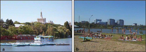
Colentina River (L = 101 km; A = 643 km2) crosses the northern part of Bucharest and flows into the Dâmboviţa River a few kilometers downstream of the city (Fig. 1). It originates in the plain, at an elevation of 179 m a.s.l., and has a mean gradient of 1 m/km (Table ). The average multiannual discharges at Colacu gauging station are very low in both natural and modified flow regimes: 0.33 and 1.46 m3/s, respectively. As a result of its different morphometric and hydrological features in comparison with the Dâmboviţa River, it was subjected to other types of engineering works. To meet the domestic water needs, the residents built a number of ponds by weirs/sluice gates emplacements. The first of such ponds (the so‐called Mogoşoaia Lake) is mentioned as early as 1702. The main nuisance caused by this river was water stagnation (because of the low discharges, gentle slopes, and shallow groundwater), a phenomenon occurring especially in summer, which was responsible for the repeated outbreaks of malaria. In 1933, statistics showed that 60–70% of the people suffering from malaria were living in the vicinity of the Colentina River (Georgescu et al. Citation1966). However, the authorities had begun to seek for solutions for the sanitation of the Colentina stream as early as 1929. The works started in 1933 and were completed by 1960. At present, on the Colentina River within the Bucharest area there are 15 ponds with multiple services: fishing, industrial water supply, flow regulation, and recreation (Fig. 5). All in all, these ponds have a volume of about 36 million m3 and an area of almost 14 km2 (the volumes and areas correspond to the normal designed stage and are according to NARW Citation2015a). The ponds are fed by the water transferred to Colentina River from the adjacent streams (Fig. 2): from the Ialomiţa River through the Bilciureşti canal (Qi = 15 m3/s) and from the Ilfov River through the Bolovani canal (Qi = 6 m3/s) (NARW Citation2015a).
Argeş River, although it does not cross the city (passing a few kilometers to the west), plays a major role for Bucharest's economic development. Together with Dâmboviţa River, it is the main source for the city's water needs. It originates in the Carpathian mountains (more precisely in Făgăraş mountains) and, due to its larger drainage area, its discharge at Budeşti gauging station is almost double (47.5 m3/s) in comparison with Dâmboviţa's (Table ). It is worth mentioning that the Argeş River and its watershed are among the most heavily managed river basins in Romania. Between 1965 and 1997, along the Argeş River 13 multipurpose reservoirs were designed (Fig. 2). The most important in terms of volume (450 million m3) is Vidraru, which is located in the mountain area.
Over the period 1985–1989, 70% of its lower course was modified as far as the junction of the Danube (near Olteniţa City), in order to be turned into a navigable waterway meant to connect Bucharest with the Danube River. After 1990, the works were abandoned and the canal has remained unfinished (Zaharia and Cocoş Citation1999).
Argeş River is regulated on almost a quarter of its length. Its course is linked with adjacent streams by nine canals for water diversion and 13 canals for water bringing (NARW Citation2015a) (Fig. 2).
Sabar River (L = 174 km; A = 1,346 km2) passes a few kilometers west of Bucharest City. It originates in the high plain region, at 349 m a.s.l., flows into the Argeş River (at 37 m a.s.l.), and has a mean slope of 2 m/km (Table ). Due to its proximity to the city, it was included in the comprehensive management scheme of the rivers in the Bucharest region. The Sabar River is very important for the flood control, inasmuch as its channel may serve as a diversion passage for the high waters flowing on the nearby rivers (Argeş, Dâmboviţa, and Potop; Fig. 2). Its multiannual discharge under natural flow regime is about 3 m3/s, but due to water received from the neighboring streams, the recorded discharge exceeds 8 m3/s (see the chapter ).
Water withdrawals
The rivers in the Bucharest region are the city's main water supply source, and they meet nearly all of its water needs. On the Dâmboviţa River, there are three water intakes. Two of them are found at the Văcăreşti dam; their role is to provide water for Bucharest City (Qi = 32 m3/s) and to supplement the discharge of the Ilfov River (Qi = 10.8 m3/s). The third intake (Qi = 20 m3/s) is situated downstream of the Ciurel dam and provides the necessary water for flushing the underground wastewater drain (NARW Citation2015a). On the Sabar River, there is only one water intake (at Jilava), which supplies water for irrigation (Qi = 10 m3/s).
Along the Argeş River, there are 13 intakes designed to provide the necessary water for various uses. The most important of them, with a designed discharge of 26.5 m3/s, is located at Crivina (Fig. 2) and ensures significant amounts of water for Bucharest City. The total designed discharge of all the water intakes installed on the Argeş River is almost 190 m3/s (NARW Citation2015a).
On the Colentina River, there are intakes only for industrial water supply located in the Pantelimon and Cernica ponds, but currently the taken volume is not significant.
To ensure the Bucharest City region's water supply, an average of 352,425 m3/d is withdrawn from the Dâmboviţa River, while 353,419 m3/d is collected from the Argeş River (the data are for 2013 and are according to NAPA Citation2014). The water extracted from the Dâmboviţa and Argeş rivers supplies three drinking treatment plants (Fig. 2). The one located at Arcuda (set up in 1888) is provided by the Dâmboviţa River and has a capacity of 650,000 m3/d. The Argeş River supplies both the Roşu treatment plant (set up in 1970), with a capacity of 520,000 m3/d, and the Crivina plant (which came into operation in 2006), with a capacity of 260,000 m3/d (Apa Nova Citation2016).
Wastewater effluents—qualitative pressures on the rivers
In urbanized areas, water quality and, consequently, aquatic ecosystem health are considerably influenced by industrial and agricultural effluents, as well as by the wastewaters collected by the public sewerage system. In the study area, Bucharest is the main city that impacts the quality of the rivers significantly (the institution responsible for the water supply and sewerage system management in Bucharest City is S.C. Apa Nova S.A.). The storm water and the wastewaters collected by the sewage system finally reach the drain that underlies the Dâmboviţa's channelized watercourse. Subsequently, they are released in the Dâmboviţa River downstream of Bucharest City (in Glina village), where the wastewater treatment plant is located (Fig. 2). Although the construction began in 1985, it is not yet fully operational and, consequently, the spilled waters are only partly purified, significantly affecting the water quality of the Dâmboviţa River and its ecological state. In 2015, the Glina wastewater treatment plant could process mechanically above 750,000 m3/d, which represents more than 85% of the total volume of wastewater collected; at the same time, it completely purged (mechanically and biologically) 60% of the total volume. The entry into full operation mode of the wastewater treatment plant is planned for 2017, when it is expected to purify the maximum wastewater discharge of 12 m3/s designed for dry periods; at present, the plant can process mechanically up to 10 m3/s of wastewater, and completely up to 5 m3/s, while the mean designed wastewater discharge collected by the sewerage system under dry weather conditions is about 12 m3/s (Mihailovici and State Citation2015). Generally, the discharged wastewaters have high concentrations in ammonium, total nitrogen, and total phosphorous, exceeding the allowed limits in the national regulation (NARW Citation2011).
Colentina River receives the wastewaters discharged from the sewerage system of the Buftea City, located north of Bucharest (Fig. 1). Having passed through the mechanical and biological treatment, the effluent discharge reaches about 0.024 m3/s. The waters spilled into Colentina River usually exceed the allowed limits for suspensions content, biochemical oxygen demand, chemical oxygen demand (chromium), total nitrogen, total phosphorous, ammonium, and detergents (NARW Citation2011).
Upstream of the Bucharest urban area, the quality of the Argeş River is altered by the socioeconomic activities carried out in Piteşti City. The main contamination source is the company responsible for water supply and sewerage (S.C. Apă Canal 2000 S.A. Piteşti) (NARW Citation2011, Soare Citation2015b). Downstream of Bucharest, Argeş River collects Dâmboviţa River's polluted waters, and consequently its quality is altered significantly.
Regarding Sabar River, it is not subjected to significant qualitative pressures, inasmuch as the settlements located on its banks are rural.
At the scale of the entire study area, the largest amounts of wastewaters that are spilled into the rivers derive from the commercial companies (S.C.) responsible for urban water management: S.C. Apa Nova Bucureşti S.A.—Glina (357.936 million m3/yr); S.C. Apă Canal 2000 S.A. Piteşti (22.102 million m3/yr); S.C. Apa Nova Bucureşti S.A.—Crivina Water Treatment Plant (5.194 million m3/yr), and S.C. Apa Nova Bucureşti S.A.—Arcuda Water Treatment Plant (4.372 million m3/yr; the data correspond to 2009 and are according to Soare‐Bratosin Citation2015). Over the period 2006–2011, of the total amount of wastewaters (urban, industrial, and agricultural) discharged in the Bucharest area (Bucharest City and the adjoining Ilfov County), which was nearly 400 million m3/yr, about 95% was not subjected to any treatment at all (according to Soare‐Bratosin Citation2015 and NAPA Citation2012).
The effects of anthropogenic pressures
The human pressures on the rivers in the Bucharest region have caused significant changes in stream network and associated landscape, as well as in flow regime and water quality; all these changes have negative consequences on the ecosystems' health.
Changes in stream network and landscape
The sprawl of Bucharest City and the river training have generated noticeable changes in the appearance of the stream network and river‐related landscapes. These changes are highlighted by the comparative analysis of cartographic representations and images from different periods. It is obvious that, on the maps dating back to the 14th, 18th, and 19th centuries, Dâmboviţa's channel shows meanders and anabranched reaches, while its floodplain shelters wetlands, lakes, and marshes (Fig. 6a, b, c). As far as the Colentina River is concerned, the maps of 1791 and 1842 (Fig. 6b, c) show that it flowed outside the city's perimeter and had some ponds and a floodplain with marshy areas.
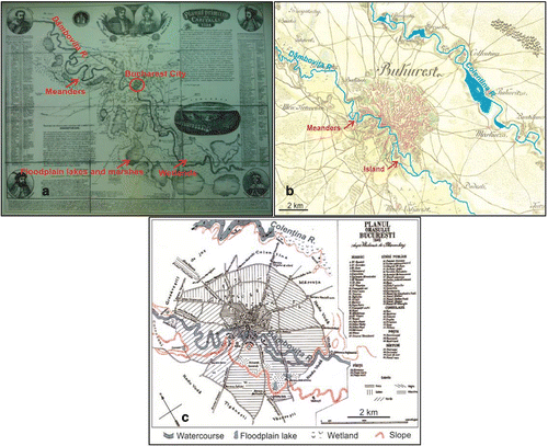
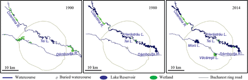
To make a diachronic analysis for the period 1900–2014, we digitized the Military Survey Maps (Planurile Directoare de Tragere) of scale 1:20,000 (1900), the topographic maps of scale 1:25,000 (1980), and Google maps imagery (2014). We were thus able to identify significant changes undergone over time by the two rivers crossing Bucharest City. Nowadays, two man‐made lakes (Lacul Morii and Văcăreşti) and an artificial channel can be seen along Dâmboviţa River, while Colentina River has turned into a chain of ponds (Fig. 7).
The present appearance of the Dâmboviţa River in Bucharest City is totally different from what it looked like in the 19th century (Fig. 8). The lakes (ponds) on Colentina River provide economic (water supply for industrial and irrigation needs, fishing), aesthetical, and recreational services (Fig. 5). The canals for interbasin water transfer (Fig. 2) have induced significant changes in the stream network appearance and the watersheds hydrology in the Bucharest region.
Impacts on river flow regime
To assess urbanization effects on the river flow regime, we processed the monthly and annual average discharges recorded at the gauging stations (GSs) located on the main rivers in the Bucharest region: the Argeş River at Malu Spart GS (upstream of Bucharest) and at Budeşti GS (downstream of Bucharest); the Dâmboviţa River at Lunguleţu GS; the Colentina River at Colacu GS; and the Sabar River at Vidra GS (the data regarding these stations are given in Table and their location is shown in Figs. 1 and 2). The analyzed periods are mentioned in Table . To quantify the differences between the natural (reconstituted) flow regime (Qn) and the modified (current) flow regime (Qm), we computed the change rate (DQ), determined as we explained in chapter Materials and methods.
1. Effects on the annual and multiannual average discharges. The analysis of the variability of the annual average discharges of the Argeş River shows an alternation in periods in which the flows in natural regime were higher than those in altered regime and vice versa (Fig. 9a, b). Thereby, after 1986 both investigated gauging stations recorded a lower flow in altered regime (on an average by 40–50%), while in the previous period the altered discharges were generally higher by 30–40% in comparison with the natural ones. The differences between the two types of regimes depend on water uses and engineering work management.
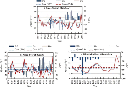
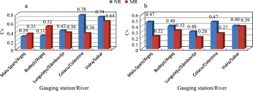
For all the analyzed periods, the differences between the multiannual average discharges in natural and modified regimes are not significant. Thus, over the period 1954–2006 the multiannual natural average discharge (Qnm) at Malu Spart GS was 39.9 m3/s, while the modified one (Qmm) was 39.4 m3/s. Downstream of Bucharest, at Budeşti GS, for the period 1950–2006, a slight drop (by 6.5%) of the Qmm (47.5 m3/s) can be noticed in comparison with the Qnm (50.6 m3/s). This fact highlights a low reduction in the mean annual flow caused by human pressures. As for the variation coefficients (Cv) of the annual average discharges, one can ascertain that human pressures have been responsible for the increase in the flow variability in modified regime as compared to the natural regime (from 0.29–0.31 to 0.35–0.52) (Fig. 10).
On the Dâmboviţa River, at Lunguleţu GS, the natural average discharges over the period 1988–2006 were generally lower than the values recorded before 1998 (Fig. 9c). After this period, there have been no significant differences between the two types of hydrological regimes. For most of this period, as in the case of the Argeş River, the difference between the multiannual discharges in natural and modified flow regimes is low (7%): Qnm = 9.9 m3/s and Qmm = 10.6 m3/s.
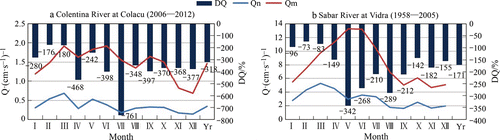
Concerning the Colentina River, at Colacu GS, during the whole analyzed period (2006–2012) the natural annual average discharges were much lower than the modified ones, the differences ranging from less than 200% to more than 1,000% (Fig. 11a), which reflects the additional inflows. Under these circumstances, the modified multiannual average discharge is 4.4 times higher than the natural one (Qmm = 1.46 m3/s and Qnm = 0.33 m3/s).
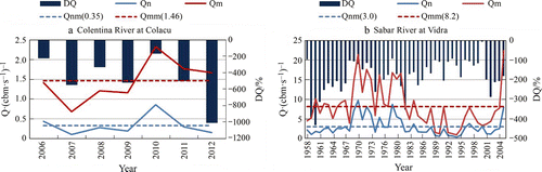
Regarding Sabar River, at Vidra GS, the annual average discharges under natural flow regime were lower than the modified ones for the entire analyzed period (1958–2005). The differences amounted to 300–400% (Fig. 11b). The multiannual average discharge in modified regime was 2.7 times higher than the natural one (Qmm = 8.2 m3/s and Qnm = 3.0 m3/s). As mentioned in a previous chapter, the river receives water from the neighboring streams.
2. Impacts on average monthly discharges. The analysis of the variation of the monthly average discharges under the two types of flow regimes (natural and modified) showed a similar situation for the Argeş and Dâmboviţa rivers. Thus, from April to June, a period that is normally characterized by high waters, the natural discharges are higher than the modified ones. Generally, for the rest of the year the modified discharges are higher than the natural ones. The positive or negative differences between the two types of regimes may reach 20–30% (Fig. 12). This situation highlights the regulatory role of the reservoirs emplaced along the rivers.
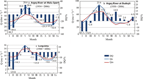
For Colentina and Sabar rivers, the situation is different from Argeş and Dâmboviţa rivers. Thus, the natural monthly average discharges are always lower than the modified ones. As a rule, the differences are higher during the warm season (April–October), when they can exceed 400% (up to 760%) on Colentina River and 200–300% on Sabar River (Fig. 13). This means that the two rivers receive additional amounts of water either for supplying the reservoirs/ponds (the case of Colentina River) or for flow regulation and floods control on Dâmboviţa and Argeş rivers (the case of Sabar River).
The variation coefficients of the monthly average discharges during the year indicate the regulatory effect of the engineering works for all the investigated gauging stations. The reduction in these coefficients is significant (about 50%) for Argeş River (at Malu Spart GS), Dâmboviţa River (at Lunguleţu GS), and Colentina River, while for Sabar River, the values are similar (0.39–0.40) for both types of flowing regimes (Fig. 10).
3. Trends in river flow variation. To identify the trends in the flow variation of the rivers crossing the Bucharest region, we applied the Mann‐Kendall test on the annual and monthly discharge data sets, under natural and modified flow regimes, for Argeş River (at Malu Spart and Budeşti gauging stations) and Sabar River (at Vidra). The test was not applied for Dâmboviţa and Colentina rivers because of the insufficient extent of the available data sets.
As Table shows, under both types of regimes (natural and modified), significant downward trends (for various levels of significance) can be noticed in spring (March–May) and in the first part of summer (June–July), when the rivers usually experience high waters. In the case of Argeş River, at both analyzed gauging stations, increasing flowing trends can be noted in September and October when, as a rule, the river flow is low. Under natural regime, the trends in the discharge variation mirror the changes in the hydroclimatic parameters identified throughout the Romanian territory and at the regional level. Thus, a reduced flow in spring and summer is a direct consequence of rainfall decrease in conjunction with temperature and evaporation increase recorded in these seasons; at the same time, the snowpack supplying the rivers in springtime decreased. The upward trends in autumn flow are justified by the season's increase in precipitation in Romania (Busuioc et al. Citation2010, Bîrsan et al. Citation2012, Citation2014, Bojariu et al. Citation2015).
Table 4. Trends in the variability of monthly and annual average discharges of the Argeş and Sabar rivers, in natural and modified flow regimes
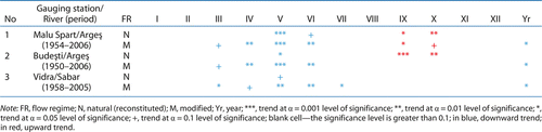
Regarding the modified flow regime, the trends are the result of cumulative influences of climate variability and anthropogenic pressure. In comparison with the natural flow regime, the trends in the modified one generally have a higher level of significance; they were identified in several months vs. natural regime, including the annual discharges. This shows the effects of anthropogenic pressures on the rivers' water resource, having as possible consequence the future decline of this resource and related water security issues.
Effects on river water quality
In Romania, river water quality is established based on the ecological state of the watercourse, according to the provisions of the European Water Framework Directive (WFD) 2000/60/EC, which have been implemented in the Romanian legislation. Consequently, the river quality is defined by taking into account biological, physicochemical, hydromorphological, and microbiological elements, each of which including specific parameters (MEWF and NARW Citation2016).
According to the WFD, the water quality classification in Romania includes five quality classes: class I—very good quality (blue color); class II—good quality (green color); class III—moderate quality (yellow color); class IV—poor quality (orange color); and class V—bad quality (red color). The classification of the ecological state relies on the principle, “one out–all out” (i.e., the worst status of the elements used in the assessment determines the final status of the waterbody), according to the WFD provision. The same principle also applies for the quality parameters belonging to the same group (biological, physicochemical, and hydromorphological elements) (MEWF and NARW Citation2015, Citation2016).
To establish the quality of the main rivers crossing the Bucharest region (the Dâmboviţa, Colentina, Argeş, and Sabar rivers), we made use of the data provided by the NARW‐AVWB for the year 2013. The analysis highlights the ecological state, based on biological and physicochemical elements (the last ones include parameters that support the biological elements). The assessment of the biological state relied on a number of parameters regarding phytoplankton, phytobenthos, and macrozoobenthos, while the physicochemical state was established based on several groups of parameters, as follows: thermal regime and acidification (TRA); oxygen regime (OR); nutrients regime (NUT); mineralization degree or salinity (SAL); natural‐specific toxic pollutants (NSTP); and other relevant chemical indicators (ORCI), like phenols, detergents, and AOX. Each of the two major categories of elements (biological and physicochemical) defined a specific quality class, and, finally, the global ecological state was established. At that time, there were no data on hydromorphological parameters.
For Dâmboviţa River, the quality parameters were determined for five monitoring sections located both upstream and downstream of Bucharest City, namely at Brezoaele, Arcuda, Bălăceanca, and Budeşti. From the biological standpoint, the waters belong to quality classes III–V, especially because of the macrozoobenthos. According to the chemical indicators, the waters belong to quality classes II–V, because the values of OR, NUT, and ORCI are higher. Given these circumstances, the global ecological state of the Dâmboviţa River corresponds to the quality classes III–V. The worst condition (poor quality and bad quality) was found at the monitoring sections located downstream of Bucharest (at Bălăceanca and Budeşti), which receive the partly treated wastewaters released from Bucharest sewerage (Table and Fig. 14).
Table 5. Biological, physicochemical, and ecological states of the main rivers crossing Bucharest City region in 2013
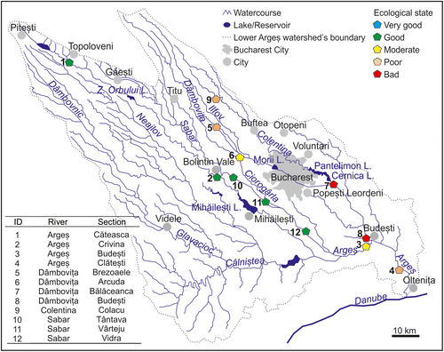
Colentina River has only one station for quality measurements, located at Colacu, upstream of Bucharest (Fig. 14). From the biological point of view, the water at this monitoring station belongs to quality class IV (because of the macrozoobenthos), while from the standpoint of the physicochemical indicators it belongs to class III (because of the ORCI indicators). Therefore, the final ecological state is indicative for class IV (Table ).
On Argeş River, four monitoring sections, located both upstream and downstream of the Bucharest City, were considered. They are located at Căteasca, Crivina (upstream of the water intake), Budeşti, and Olteniţa (Fig. 14). The analyses showed that from the biological and physicochemical points of view, upstream of Budeşti, the waters belong to quality classes II and III. Downstream of this locality, as the river receives the polluted waters of the Dâmboviţa River, water quality worsens, and at Clăteşti monitoring section it belongs to quality class IV, because of certain biological (phytoplankton, macrozoobenthos) and physicochemical (nutrients) indicators (Table ).
Concerning the Sabar River, three monitoring sections were considered, located at: Tântava, Vârteju, and Vidra. As the pressures on this river are lower, water quality is better in comparison with the other streams, and it is therefore included in quality class II (Table and Fig. 14).
Discussions and Conclusions
The intensive human pressures on the aquatic ecosystems in urbanized areas have led to significant quantitative, qualitative, and ecological changes, affecting their structure, functions, services, and health. The quality and, consequently, the ecological integrity/ecosystem health of any given stream are negatively correlated with the urbanization intensity in its surrounding watershed (Miltner et al. Citation2004, Oliveira and Cortes Citation2006). Given that a healthy ecosystem is crucial to provide services for society and the natural environment, designing workable strategies to achieve and maintain ecosystem health is a key future challenge for the society (Lu et al. Citation2015).
This paper showed the example of the Bucharest City region, which is the largest urbanized area in Romania. In the first part, the main urban pressures on the river systems (by dams, reservoirs/ponds, canals for interbasin water transfers and water intakes) are presented, while in the second part, some of the effects of these pressures on the stream network and related landscape, flow regime, and water quality are highlighted.
The engineering works in the Bucharest region are included in the complex management scheme of the Argeş River watershed, in which it is located. The study focuses on four streams, of which two cross Bucharest City (Dâmboviţa and Colentina rivers) and two pass near its western boundary (Argeş and Sabar rivers); the latter have an important role in the river scheme management in the Bucharest region. The diachronic analysis of the maps from different periods (starting with the 14th century) highlighted significant hydrographic and landscape changes, both within the city and in its hinterland.
In terms of effects on the flow regime, the two allochthonous rivers (Argeş and Dâmboviţa) did not exhibit significant alterations in the multiannual average discharges, but only the attenuation of monthly discharge variability (the average discharges in modified flow regime are lower in high water season and higher in low water periods when compared to natural regime) due to the regulatory role of the reservoirs. On the autochthonous streams (Sabar and Colentina), a significant increase in the annual and monthly average discharges was found, due to water transferred from the neighboring rivers. The trend analysis of the annual and monthly average discharges, under natural (reconstituted) and modified (current) regimes, showed significant downward trends (for various levels of significance) in spring (March–May) and in the first part of summer (June–July), while in the first part of autumn (September and October) an increasing trend was found. Under natural regime, the trends in discharge variation mirror the changes in the hydroclimatic parameters identified throughout the Romanian territory and at regional level, while in modified regime, the trends are the result of cumulative influences of climate variability and anthropogenic pressure. In comparison with the natural flow regime, the trends in the modified one generally have a higher level of significance and they were identified in several months vs. natural regime, including annual discharges.
Given that the rivers in the Bucharest region collect the wastewaters released by the urban sewage systems, which are only partially treated, the water quality of these rivers is impaired. The most heavily altered is Dâmboviţa River, which receives the wastewaters from Bucharest's sewage system, as well as the wastewaters discharged by drinking water treatment plants. Under these circumstances, downstream of Bucharest, the ecological state of the Dâmboviţa River falls in the worst quality class V (bad waters), while the Argeş River, downstream of the confluence with Dâmboviţa, falls in class IV (poor waters).
Despite the hydrographic, hydrological, and qualitative changes induced by the urban pressures in the Bucharest region, all these rivers are vital for the city's functionality and its economic development. The engineering works proved to be effective for meeting the water demands of the urbanized area and for its flood defense. Thus, for about 40 yr (since the 1970s), Bucharest City has been protected by the flooding caused by overflowing rivers. However, the flooding caused by storm waters, which are specific to urban areas, is still a threat. Its occurrence could be diminished through the expansion and modernization of the sewerage system, but also through finding alternative techniques to the classical sewerage network that favor rainwater infiltration and storage (Zaharia Citation2006).
In general, Dâmboviţa and Colentina rivers are well integrated in the urban landscape and provide, among others, aesthetic and recreation services. The Dâmboviţa River, however, still requires works in order to improve the unaesthetic appearance caused by its artificial concrete channel. The river also should be better integrated and valorized in the urban development in Bucharest City, mainly through its recreational function. But the major problem to be solved is the water quality of the region's rivers, especially in the case of the two main streams, Dâmboviţa and Argeş. It is expected that, as soon as the Glina wastewater treatment station starts operating at full capacity, the rivers' quality downstream of Bucharest and the related ecosystem health will improve significantly.
In perspective, we believe that the development of urban stream restoration projects in the Bucharest City region will solve some of the specific problems concerning the urban pressures on the stream system in the area. Many studies on this topic (Lepori et al. Citation2005, Niezgoda and Johnson Citation2005, Bukaveckas Citation2007, Kaushal et al. Citation2008, Sivirichi et al. Citation2011, McMillan et al. Citation2014, Sommerhaeuser Citation2016) showed the benefits of stream restoration projects in urbanized areas. Stream restoration is considered to be an urban adaptation in response to watershed impairments, as it has an important role in the transition from a Sanitary City to a Sustainable City (Kaushal et al. Citation2015).
To maintain and improve the ecosystem health, urban strategies promoting social–ecological sustainability should be designed. They should be based on the understanding of mutual interactions within social–ecological systems and should include preemptive actions aiming to maintain the vitality of ecosystems (Lu et al. Citation2015). Nowadays, a challenge in urban development is the deployment of ecological urbanism, considered to be a way toward sustainable cities (Pickett and Zhou Citation2015). In Bucharest City, the Integrated urban development plan (IUDP) “Central zone,” approved in 2012 and adopted at the beginning of 2016 by the General Council of the Bucharest Municipality, is a major and ambitious plan for the restoration and enhancement of the urban identity. IUPD includes many projects aiming at harmonious and sustainable development of the urban area, based on its needs and potential. One of the priorities of IUPD is to regain the attractiveness of the Dâmbovi-a River (BCH Citation2012). If so far the Dâmbovi-a River's engineering was considered mainly as a public utility infrastructure, according to the IUPD, the river should become a valuable urban element as in other capitals and European cities, such as Paris, Vienna, Budapest, Prague.
Acknowledgments
We kindly thank the National Administration “Romanian Waters”—Argeş‐Vedea Water Branch for providing the data used in this manuscript. We also thank our colleague Romulus Costache who helped us with the design of Fig. 1.
Related Research Data
Literature Cited
- Apa Nova. 2016. Uzinele de tratare. http://www.apanovabucuresti.ro/servicii/serviciul-public-de-alimentare-cu-apa/captarea-tratarea-si-distributia-apei/uzinele-de-tratare/
- Aquaproiect. 1992. Atlasul Cadastrului Apelor din România. Ministerul Mediului, Bucureşti, Romania.
- Barles, S. 2007. Urban metabolism and river systems: an historical perspective – Paris and the Seine, 1790–1970. Hydrology and Earth System Sciences 11:1757–1769.
- BCH [Bucharest City Hall]. 2012. Integrated urban development plan “Central zone” [in Romanian]. http://www4.pmb.ro/wwwt/L52/docs/01_20120412.pdf
- Bîrsan, M. V., L. Zaharia, V. Chendeş, and E. Brănescu. 2012. Recent trends in streamflow in Romania (1976–2005). Romanian Reports in Physics 64:275–280.
- Bîrsan, M. V., L. Zaharia, V. Chendeş, and E. Brănescu. 2014. Seasonal trends in Romanian streamflow. Hydrological Processes 28:4496–4505.
- Bojariu, R. et al., 2015. Schimbările climatice – de la bazele fizice la riscuri şi adaptare. Editura Printech, Bucureşti, Romania.
- Bukaveckas, P. A. 2007. Effects of channel restoration on water velocity, transient storage, and nutrient uptake in a channelized stream. Environmental Science & Technology 41:1570–1576.
- Busuioc, A., M. Caian, S. Cheval, R. Bojariu, C. Boroneant, M. Baciu, and A. Dumitrescu. 2010. Climate variability and change in Romania. Editura Pro Universitaria, Bucureşti, Romania.
- Ceola, S., F. Laio, and A. Montanari. 2015. Human pressure on rivers is increasing worldwide and threatens water security. Pages 109–110 in Christophe Cudennec, Siegfried Demuth, Anil Mishra, and Gordon Young, editors. Proceedings of the 11th Kovacs Colloquium, June 16–17, 2014, Paris. Proceedings of the International Association of Hydrological Sciences, 366. Copernicus GmbH, Gottingen, Germany.
- Chin, A. 2006. Urban transformation of river landscapes in a global context. Geomorphology 79:460–487.
- Cocoş, O. 1999. Sistemele hidrografice şi gestionarea apei în municipiul Bucureşti. First edition. Edition du Goéland, Bucureşti, Romania.
- Cocoş, O. 2006. Managementul apei în Municipiul Bucureşti. First edition. Editura Ars Docendi, Bucureşti, Romania.
- Crăciunescu, V., I. Rus, Ş. Constantinescu, I. Ovejanu, and Z. Bartos‐elekes. 2011. Planurile directoare de tragere. http://www.geo-spatial.org/download/planurile-directoare-de-tragere
- Georgescu, F., A. Cebuc, and P. Daiche. 1966. Probleme edilitare bucureştene. Alimentarea cu apă, canalizarea Dâmboviţei, asanarea lacurilor din nordul capitalei. First edition. Muzeul de istorie al oraşului Bucureşti, Bucureşti, Romania.
- Gherasim, C. C. 2005. Bucureştiul reflectat în documente cartografice. Dissertation. Universitatea din Bucureşti, Bucureşti, Romania.
- Giurescu, C. C. 1967. Istoria Bucureştilor. First edition. Editura pentru literatură, Bucureşti, Romania.
- Grimm, N. B., S. H. Faeth, N. E. Golubiewski, C. L. Redman, J. G. Wu, X. M. Bai, and J. M. Briggs. 2008. Global change and the ecology of cities. Science 319:756–760.
- Haidvogl, G., M. Guthyne‐horvath, S. Gierlinger, S. Hohensinner, and C. Sonnlechner. 2013. Urban land for a growing city at the banks of a moving river: Vienna's spread into the Danube island Unterer Werd from the late 17th to the beginning of the 20th century. Water History 5:195–217.
- Hohensinner, S., B. Lager, C. Sonnlechner, G. Haidvogl, S. Gierlinger, M. Schmid, F. Krausmann, and V. Winiwarter. 2013b. Changes in water and land: the reconstructed Viennese riverscape from 1500 to the present. Water History 5:145–172.
- Hohensinner, S., C. Sonnlechner, M. Schmid, and V. Winiwarter. 2013a. Two steps back, one step forward: reconstructing the dynamic Danube riverscape under human influence in Vienna. Water History 5:121–143.
- Ionescu, A., L. Dumitrescu, and G. Răducu. 1988. Unele probleme ale proiectării colectorului general de canalizare realizat în cadrul lucrărilor de amenajare complexă a râului Dâmboviţa în municipiul Bucureşti. Hidrotehnica 33:27–30.
- Iordan, I. 1977. Zona periurbană a Bucureştilor. Editura Academiei R.S.R., Bucureşti, Romania.
- Kaushal, S. S., P. M. Groffman, P. M. Mayer, E. Striz, and A. J. Gold. 2008. Effects of stream restoration on denitrification in an urbanizing watershed. Ecological Applications 18:789–804.
- Kaushal, S. S., W. H. Mcdowell, W. M. Wollheim, T. A. Newcomer johnson, P. M. Mayer, K. T. Belt, and M. J. Pennino. 2015. Urban evolution: the role of water. Water 7:4063–4087.
- Kennedy, C., J. Cuddihy, and J. Engel‐yan. 2007. The changing metabolism of cities. Journal of Industrial Ecology 11:43–59.
- Leopold, L. B. 1968. Hydrology for urban land planning: a guidebook on the hydrologic effects of urban land use. First edition. US Government Printing Office, Washington, D.C., USA.
- Lepori, F., D. Palm, and B. Malmqvist. 2005. Effects of stream restoration on ecosystem functioning: detritus retentiveness and decomposition. Journal of Applied Ecology 42:228–238.
- Lu, Y., R. Wang, Y. Zhang, H. Su, P. Wang, A. Jenkins, R. C. Ferrier, M. Bailey, and G. Squire. 2015. Ecosystem health towards sustainability. Ecosystem Health and Sustainability 1:2.
- Mcdonald, R. I., I. Douglas, N. B. Grimm, R. Hale, R. Revenga, C. Gronwall, and B. Fekete. 2011a. Implications of fast urban growth for freshwater provision. Ambio 40:437–447.
- Mcdonald, R. I., P. Green, D. Balk, B. Fekete, C. Revenga, M. Todd, and M. Montgomery. 2011b. Urban growth, climate change, and freshwater availability. Proceedings of National Academy of Sciences USA 108:6312–6317.
- Mcdonald, R. I., P. Marcotullio, and B. Güneralp. 2013. Urbanization and trends in biodiversity and ecosystems services. Pages 31–52 in T. Elmqvist, M. Fragkias, J. Goodness, B. Güneralp, P. J. Marcotullio, R. I. Mc donald, S. Parnell, M. Schewenius, M. S. Seto, and K. C. Wilkinson, editors. Urbanization, biodiversity, and ecosystem services: challenges and opportunities. Springer, New York, New York, USA.
- Mcdonald, R. I. et al., 2014. Water on an urban planet: urbanization and the reach of urban water infrastructure. Global Environmental Change 27:96–105.
- Mcmillan, S. K., A. K. Tuttle, G. D. Jennings, and A. Gardner. 2014. Influence of restoration age and riparian vegetation on reach‐scale nutrient retention in restored urban streams. Journal of American Water Resources Association 50:626–638.
- MEWF [Ministry of Environment, Water and Forests], and NARW [National Administration Romanian Waters]. 2015. Planul Na-ional de Management aferent por-iunii na-ionale a bazinului hidrografic interna-ional al fluviului Dunărea. http://www.rowater.ro/TEST/Planul%20National%20de%20Management%202010%20-%20Sinteza%20planurilor%20de%20management%20la%20nivel%20de%20bazine-spatii%20hidrografice/Plan%20National%20Management%20-%20sinteza%20-%20vol.I%20%20final(februarie).pdf
- MEWF [Ministry of Environment, Water and Forests], and NARW [National Administration Romanian Waters]. 2016. Watershed management plan of Argeş – Vedea Water District. http://www.rowater.ro/daarges/SCAR/Planul%20de%20management.aspx
- Meyer, J. L., M. J. Paul, and W. K. Taulbee. 2005. Stream ecosystem function in urbanizing landscapes. Journal of North American Benthological Society 24:602–612.
- Mihailovici, M., and R. State. 2015. Evoluţia epurării apelor uzate în municipiul Bucureşti. Hidrotehnica 60:25–34.
- Miltner, R. J., D. White, and C. Yoder. 2004. The biotic integrity of streams in urban and suburbanizing landscapes. Landscape and Urban Planning 69:87–100.
- NAPA [National Environmental Protection Agency]. 2012. Report on environmental state in Region 8 Bucharest‐Ilfov in 2011 [in Romanian]. http://www.anpm.ro/web/apm-bucuresti/rapoarte-anuale1
- NAPA [National Environmental Protection Agency]. 2014. Report on environmental state in Bucharest City in 2013 [in Romanian]. http://www.anpm.ro/web/apm-bucuresti/rapoarte-anuale1.
- NARW [National Administration Romanian Waters]. 2011. Watershed management plan of Argeş – Vedea Water District [in Romanian]. http://www.rowater.ro/daarges/SCAR/Planul%20de%20management.aspx
- NARW [National Administration Romanian Waters]. 2015a. Watershed flood defense plan, Argeş‐Vedea Water Branch [in Romanian]. http://www.rowater.ro/daarges/Continut%20Site/Planuri%20de%20aparare/Planuri%20bazinale.aspx
- NARW [National Administration Romanian Waters]. 2015b. County flood defense plans, Argeş‐Vedea Water Branch [in Romanian]. http://www.rowater.ro/daarges/Documente%20Planuri%20Judetene/Forms/AllItems.aspx
- Niezgoda, S. L., and P. A. Johnson. 2005. Improving the urban stream restoration effort: identifying critical form and processes relationships. Environmental Management 35:579–592.
- O'driscoll, M., S. Clinton, A. Jefferson, A. Manda, and S. Mcmillan. 2010. Urbanization effects on watershed hydrology and in‐stream processes in the southern United States. Water 2:605–648.
- Oliveira, S. V., and R. M. V. Cortes. 2006. Environmental indicators of ecological integrity and their development for running waters in northern Portugal. Limnetica 25:479–498.
- Paul, M. J., and J. L. Meyer. 2001. Streams in the urban landscape. Annual Review of Ecology and Systematics 32:333–365.
- Pickett, S. T. A., G. L. Buckley, S. S. Kaushal, and Y. Williams. 2011. Social‐ecological science in the humane metropolis. Urban Ecosystems 14:319–339.
- Pickett, S. T. A., and W. Zhou. 2015. Global urbanization as a shifting context for applying ecological science toward the sustainable city. Ecosystem Health and Sustainability 1:5.
- Pişota, I., and C. Moissiu. 1977. Hidrografia Bucureştiului şi a împrejurimilor sale. Pages 24–30 in Societatea De ştiinţe geogafice, editor. Geografia municipiului Bucureşti şi a Judeţului Ilfov. Întreprinderea Poligrafică ”Bucureştii‐Noi”, Bucureşti, Romania.
- Popescu, C., and F. Lăzărescu. 1988. Concepţia generală de amenajare a râului Dâmboviţa în municipiul Bucureşti. Hidrotehnica 33:3–9.
- RSDBM [Regional Statistical Division of Bucharest Municipality]. 2014. Bucharest statistical yearbook. RSDBM, Bucureşti, Romania.
- Sivirichi, G. M., S. S. Kaushal, P. M. Mayer, C. Welty, K. T. Belt, T. A. Newcomer, K. D. Newcomb, and M. M. Grese. 2011. Longitudinal variability in streamwater chemistry and carbon and nitrogen fluxes in restored and degraded urban stream networks. Journal of Environmental Monitoring 13:288–303.
- Soare, M.. 2015a River water quality in the lower catchment of the Argeş River. Riscuri şi Catastrofe 14:123–135.
- Soare, M. 2015b. Characteristics of flow in the lower catchment of the Argeş River. Riscuri şi Catastrofe XIV:83–94.
- Soare‐bratosin, M. 2015. Bazinul inferior al râului Argeş. Studiu de hidrologie şi calitatea apelor. Dissertation. Universitatea din Bucureşti, Bucureşti, Romania.
- Solacolu, P. 1988. Încadrarea amenajării complexe a râului Dâmboviţa în schema cadru a bazinului hidrografic. Hidrotehnica 33:10–16.
- Solacolu, P., and O. Ceachir. 1981. Schema de apărare a Capitalei împotriva inundaţiilor. Hidrotehnica 26:76–79.
- Sommerhaeuser, M. 2016. The Emscher re‐conversion: a large scale river restoration project and its effects on river ecology, biodiversity and improvement of quality of life in one of the Europe's most densely populated areas. Page 41 in Petre Gâştescu and Petre Breţcan, editors. Book of abstract of the 3rd International Conference Water resources and wetlands,Tulcea, September 8–10, 2016. Editura Transversal, Târgovişte, Romania.
- Su, C. H., B. J. Fu, C. S. He, and Y. H. Lü. 2012. Variation of ecosystem services and human activities: a case study in the Yanhe Watershed of China. Acta Oecologica 44:46–57.
- Walsh, C. J., A. H. Roy, J. W. Feminella, P. D. Cottingham, P. M. Groffman, and R. P. Morgan. 2005. The urban stream syndrome: current knowledge and the search for a cure. Journal of the North American Benthological Society 24:706–723.
- Zaharia, L. 2006. Tehnicile alternative la sistemele clasice de canalizare şi rolul lor în diminuarea riscului la inundaţiile pluviale urbane. Riscuri şi Catastrofe V:43–54.
- Zaharia, L., and O. Cocoş. 1999. Management schemes and their impact on runoff regime of the rivers in the Bucharest city area. Pages 79–84 in Virgil Surdeanu, editor. Geography within the context of contemporary development. Napoca Star, Cluj‐Napoca, Romania.
- Zaharia, L., P. Stanciu, and A. Stanciu. 1997. L'effet de la variabilité climatique et des aménagements sur l'écoulement liquide dans le bassin‐versant de l'Argeş. Analele Universităţii din Bucureşti seria Geografie XLVI:89–97.