
Abstract
The present study is an attempt to evaluate the availability of using the groundwater for different purposes at Manfalut District, Assuit Governorate. Chemical analysis of water samples in the study area at Manfalut District are located between latitudes 27°00′ & 27°30′ North and longitudes 30°30′ & 31°00′ East. It is bounded to: the East by the River Nile, the North by El-Qusiya District, the South by Assuit District and the West by the Western Desert.
The concentration of total dissolved salts (TDS) of groundwater in the studied area ranges from 256 to 2816 ppm. The minimum TDS 256 ppm was recorded in the area located near Naga Hammadi canal. The maximum TDS was found in the western part near desert. This TDS level has been affected by the soil leaching and the diffusion of marine groundwater from the Miocene aquifer located in the west.
The well samples which can be used in drinking purposes according to WHO standards are located in west area of River Nile, while the sample located at the second region in the western area cannot be used for drinking or domestic uses due to very high salinity.
The concentrations of trace elements in the groundwater of Manfalut District were generally within the permissible limits for irrigation. No toxicity will arise by using water for permanent irrigation in all soils. However, the slight increase in Cadmium concentration in most wells should be removed first from groundwater in the study area.
1 Introduction
River Nile is considered the life nerve of Egypt. It represents the main source of drinking and irrigation water. Its amount is limited due to the increase demand for irrigation. As a result of the lack of the Nile water and the uncontrolled increase of population in during the last decades, people and scientists were directed towards other non-conventional sources of water such as groundwater.
Regionally, groundwater flow was toward the north along the valley and laterally away from the River Nile. Some downward flow penetrates the semi confining Holocene clay as recharge to the aquifer and carries pollutants to the aquifer (CitationAbu-Zeid, 1995). The uncontrolled construction, the inadequate capacity of the sewerage network, and the high rate of vertical leakage increases the amount of deteriorated water that infiltrates downward to affect the aquifer (CitationAbu-Zeid, 1995).
The Nile Valley receives great attention for a long time. Many works were carried out dealing with geological, hydrogeological, hydrochemical and environmental conditions as reported by CitationRIGW/IWACO (1989), CitationAtta (1991), CitationEl Arabi (1995), CitationAbdel Gelil (2004), CitationAtta et al. (2004), CitationDawoud et al. (2006) and CitationSoliman (2007), respectively.
2 Location of the study area
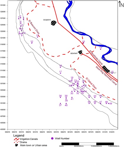
Manfalut District is located between latitudes 27°00′ & 27°30′ North and longitudes 30°30′ & 31°00′ East. It is bounded, to the East by the River Nile, to the North by El-Qusiya District, to the South by Assuit District and to the West by the Western Desert as shown in .
3 Objective and methodology
3.1 Objective
The aim of the present study is to assess the geological, hydrogeological and hydrochemical characteristics of groundwater at Manfalut District and suitability of groundwater for different purposes. This purpose water samples were collected from 49 wells constructed at different depths varying from 22 to 200 m in Manfalut District as shown in .
3.2 Methodology
The groundwater samples were collected in two liters polyethylene bottles. Physico-chemical analyses were carried out as specific electric conductance (EC), nitrate and pH measurements. Second sample was acidified with 1 ml concentrated nitric acid to analyze the trace elements. The chemical analyses were carried out in the Central Laboratories of National Water Research Center according to the CitationAmerican Public Health Association (APHA) (2012).
4 Geo-morphological and geological settings
The lateral slopes are very gentle all over the valley ending with the high plateau to the west. The land surface drops gently from about 54 m to 49 m above sea level in the longitudinal direction (northward). In the fringes, the slope is very high in comparison with topography of the flood plain where the land surface elevation ranges between 100 and 200 m (Topographic Map of Manfalut Area, CitationRIGW, 1994).
4.1 Geomorphologic units
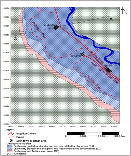
The study area represents the northern part of the Upper Egypt. The following geomorphologic units can be recognized in the Nile Valley as shown in .
4.1.1 The young alluvial plains of the Nile
The young alluvial plains dominate the cultivated lands bordering the River Nile from the west and the drains dissect them as shown in . The young alluvial plains are almost flat and sloping regionally from south to north. The surface sediments were formed via the disintegrate igneous, metamorphic rocks of the Ethiopian plateau and south of Sudan (CitationAwad, 1999). The sediments were transported by the River Nile and its tributaries to the Delta during the repetitive flood seasons for more than ten thousand years. The level of alluvial plains ranges from 49 m in the north to 54 m in the south.
4.1.2 The old alluvial plains of the Nile
The old alluvial plains are formed along the both sides of the Nile Valley as shown in . It was exposed as terraces found at various heights above the young alluvial plains and consists of sand and gravels. The deposits were formed in the Pleistocene and Holocene age. The level of old alluvial plains ranges from 100 m to 150 m. They formed gently undulating dissected pedeplains surface made up of serial board bench-like gravelly terraces interfingering and occasionally overhanging each other. The terraces were formed as a result of the aggradation and degradation of the Nile Valley relative to the eustatic changes of the ultimate base level of the Mediterranean. The old alluvial plains occupied the areas between the foot slopes of the Eocene scarps and the cultivated flood plains. Most of the reclaimed areas of the Nile Valley and Delta fringes were found in those old alluvial plains.
4.1.3 Limestone plateau (The Calcareous Plateau)
These plateaux were made up of the weathered resistant hard limestone of Eocene age which consisted of carbonate rocks. It is bounding the Nile Valley from its eastern and western sides and terminating with cliffs overlooking the flood plain. The eastern plateau was topographically higher and highly dissected by faulting than the western plateau (CitationAwad, 1999). These plateaus are drained by a great number of vallies that cut deeply through the Eocene rocks as shown in . The level of limestone plateau ranged from 150 m to 200 m depth.
4.2 Subsurface geology
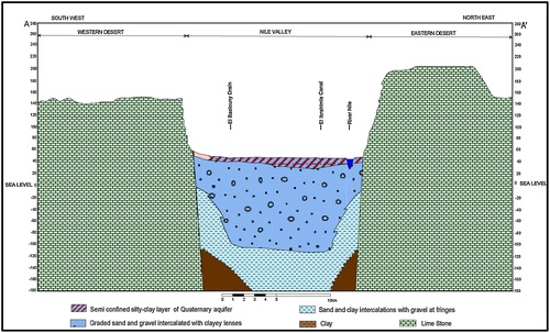
The sequence of deposits rocks of wells have been investigated through the study of hydrogeological cross section A–A′ that is located in . This figure shows that, the study area represents a part of the Upper Egypt and the surrounding plateaus on both sides. illustrates the lithological cross section in the northern region from which, it was noticed that the main aquifer is consisted of medium to coarse sand and gravel formation with clay lenses in some localities from Pleistocene age. The aquifer thickness reached 300 m. The aquifer thickness was reduced in both sides to reach 20 m depth. The aquifer was coverlained by a silty clayey layer with a thickness ranged between 0.5 m and 20 m. The main aquifer is underlained by Pliocene clayey deposits and bounded from west and east by the Eocene Limestone formation.
5 Hydrogeological review
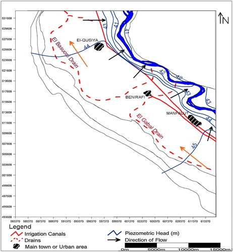
Canals and drains are playing an important role in the water regime of the study area. The existing surface water system mainly cut through sands, therefore, a direct connection between the surface water and groundwater system. The seepage from surface water to groundwater and vice versa depends on water levels in both.
shows the water level contour lines of the GW in the west of River Nile, GW level slopes gently towards the River Nile direction from level 44 m to 41 m. In the longitudinal direction, the groundwater flows from south to north from 45 m to 44 m. The River Nile is considered as a drain for the aquifer. The increase of groundwater levels in the west is still due to the farmer’s behavior since old lands moved to the desert and started to reclaim the new land along the fringes of the study area (CitationAtta, 2014).
6 Hydro-chemical study
6.1 Total dissolved salts
The obtained results of the total dissolved salts (TDS) in the groundwater samples at the studied wells and the irrigation canals are given in and , respectively. It is evident that the TDS is mainly governed by the geographical position of each locality. It shows that the TDS of the groundwater in the studied area ranges from 256 to 2816 ppm. The minimum total dissolved salts 256 ppm was recorded in well No. 16 in the area due to seepage of the excess irrigation water to the groundwater. The maximum was found in well No. 12 in the western part near desert as shown in . shows the distribution and contour lines of Manfalut District map. From the map, it is notice that the water with TDS less than 1000 ppm was found in the eastern part of the studied area. This saline water is nearly similar to that of the Nile irrigation water, Ibrahimia canal & Nag Hammadi canal (235, 263 & 250) ppm, respectively which is the main groundwater source of the water aquifer. However, the higher TDS in the Nile water is probably due to the Seepage of surface water loaded with agriculture drainage and subsoil water that contains considerable amounts of soluble salts.
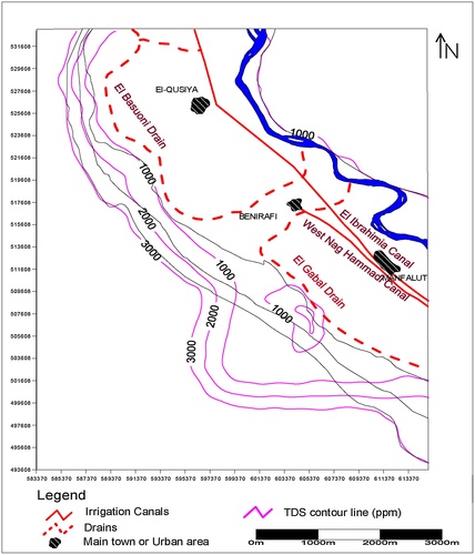
Table 1 Chemical analysis of groundwater samples.
Table 2 Chemical analysis of irrigation canals.
The class of highly saline water that ranges between 1000 and 2000 ppm is located in the western part of the studied area. This TDS level was affected by the soil leaching and the diffusion of marine groundwater from the Miocene aquifer located in the west. The high salinity is also due to the extensive withdrawing of groundwater to reclaim the desert areas. The class of highly saline water with more than 2000 ppm was located in the western part. This salinity level is affected by invasion of marine water from Miocene aquifer in the west. The marine water from Miocene aquifer pollutes the groundwater of the Pleistocene aquifer, and increases the salinity from less than 1000 ppm to more than 2000 ppm.
6.1.1 pH value in Manfalut District
shows that the studied samples of water have pH values ranging between 7.2 and 8.1 that is in the range of slightly alkaline water. The minimum pH value was found in wells Nos. 1 & 4, while the maximum pH value was found in well No. 8. Generally, the pH values in most wells were slightly alkaline.
6.2 Nitrate (NO3−)
Nitrogen fertilizers including ammonium sulphate, ammonium nitrate, urea and animal wastes (manure) are the main sources of nitrate in the groundwater. These fertilizers provide plants with their need of nitrate, while the excess nitrogen fertilizers cause the increase of nitrate of groundwater. In terms of a real extent, agriculture is one of the most widespread human activities that can affect groundwater quality.
Results showed that the nitrate content in the groundwater of Manfalut District was very low in all samples as shown in . The concentration of nitrate varies between 0.45 to 5.6 ppm with an average 2.3 ppm. The minimum value was observed in well No. 15 and the maximum value was detected in well No. 19 with an average 2.3 ppm. The decrement of nitrate may be due to the denitrification process by acting bacteria, the oxygen in nitrate ions is consumed by denitrifying bacteria resulting decrease of nitrate and produce N2 gas.
6.3 Trace elements
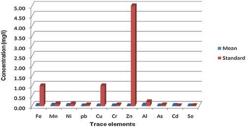
The term heavy metal refers to any metallic chemical element that has a relatively high density at least 5 times the density of water and is toxic or poisonous at low concentrations. Heavy metals include Iron (Fe), Manganese (Mn), Nickel (Ni), Lead (Pb), Copper (Cu), Chromium (Cr), Zinc (Zn), Aluminium (Al), Arsenic (As), Cadmium (Cd), Selenium (Se), Cobalt (Co) and Antimony (Sb). Trace elements were determined in the 32 groundwater samples in the study area to evaluate the quality of water and to identify the toxic effects of these elements. The results of the determination of trace elements in the groundwater samples from Manfalut area are shown in .
Table 3 Trace elements analyses (ppm).
6.3.1 Iron (Fe)
Iron is a very common element in the earth crust, it is very important for all living organic matters. The concentration of iron in Manfalut District was less than 0.02 ppm in all wells.
6.3.2 Manganese (Mn)
The geochemistry of manganese was similar to that of iron. In general the concentration of manganese in water is less than that of iron. The manganese content in Manfalut District varies between less than 0.006 ppm and 0.097 ppm with an average 0.0515 ppm. The minimum value is observed in most of wells and the maximum value is observed in well 6, 16, 37, 44 & 48.
6.3.3 Nickel (Ni)
Nickel occurs naturally in soils, groundwater and surface waters. It generally gets into water from mining and refining operations. Nickel content in the groundwater in the study area varies between less than 0.001 and 0.031 ppm with an average 0.016 ppm. The lower value is observed in most of wells and the high content of nickel ion in wells Nos. 2, 4, 5, 16, 17, 31, 35, 43 & 48, respectively.
6.3.4 Lead (Pb)
Lead is a toxic metal that is harmful to human health; there is no safe level for lead exposure. The concentration of lead content in the groundwater in the study area is less than 0.001 ppm.
6.3.5 Copper (Cu)
Copper is found in surface water, groundwater, and seawater. Copper content in Manfalut District reaches to less than 0.001 ppm. Generally, the concentration of copper is considered low concentration of groundwater and it can be used for all purposes. Low content of copper in the study area is mostly due to lack of copper minerals, the strong attachment of copper to organic matter and soil particles.
6.3.6 Chromium (Cr)
Chromium is a naturally occurring metal that forms in drinking water compounds with valences of +3 and +6, with the trivalent state being the most common. The concentration of chromium content in the groundwater in the study area was very low and reaches to less than 0.001 ppm in all wells.
6.3.7 Zinc (Zn)
Zinc can occur in industrial wastewater as well as a natural component of many minerals, dissolved from galvanized pipes and in pesticides. Zinc content in the groundwater samples in Manfalut District reaches to less than 0.001 ppm in all wells.
6.3.8 Aluminium (Al)
Aluminium is the third abundant of the elements in the earth's outer crust. It rarely occurs in natural water in concentration greater than a few tenths of a milligram per liter. The concentration of aluminium content in the groundwater in the study area was very low and varied between 0.005 and 0.133 ppm with an average 0.069 ppm. The lower value was observed in most of wells and the high content of aluminium ion in wells Nos. 6, 15 & 48.
6.3.9 Arsenic (As)
Arsenic, in rocks may occur in reduced form as mineral veins and/or oxide. Arsenic content in the groundwater samples in Manfalut District reached to less than 0.001 ppm in all wells.
6.3.10 Cadmium (Cd)
Cadmium content varied between 0.02 ppm and 0.021 ppm. The concentration of cadmium in all wells is considered the same.
6.3.11 Cobalt (Co)
Cobalt is known to be essential in plant and in animal nutrition, but is required only in very small quantities. The concentration of cobalt content in the groundwater in the study area is very low and varies between less than 0.01 to 0.012 ppm. The concentration of cobalt in all wells was considered the same.
6.3.12 Selenium (Se)
The intake of selenium by animals is mainly from vegetation. Selenium content in the groundwater samples in Manfalut District reaches to less than 0.001 ppm in all wells.
6.3.13 Antimony (Sb)
Antimony content in the groundwater samples in Manfalut District reaches to less than 0.001 ppm in all wells.
7 Results and discussion
7.1 Water evaluation and suitability to use
The quality of water resources in Egypt has been accepted to have a great importance during the last ten years as its quantity. Good quality water saves the health of people and protects crops from dangerous pollution. Clean water is simply provides good health. The quality parameters are represented in terms of many standards, which were set to a specific use. It proposes the principle parameter, which was used in the evaluation of the quality of water for different purposed.
7.1.1 Suitability of water for drinking and domestic purposes
Chemicals in drinking water, which are toxic, may cause either acute or chronic health effects. An acute effect usually follows a large dose of a chemical and occurs almost immediately. The levels of chemicals in drinking water are seldom high enough to cause acute health effects. Water for drinking and domestic uses should be colorless, odorless, clear and free from excessive dissolved solids as well as harmful organism. It has high standards of physical, chemical and microbiological purity. Generally, water for potable uses should have good quality, with total dissolved salts not exceed 500 mg/l according to CitationWorld Health Organization (1998) as shown in .
Table 4 Standard concentration given by CitationWHO (1998).
By applying the international standards recommended by CitationWHO (1998), on these analyzed water samples, the following could be deduced. In the present study the TDS varies between 256 to 2816 ppm as shown in . The well samples which can be used in drinking according to standards of CitationWHO (1998) are first area in west of River Nile. The second region in the western area cannot be used for drinking to very high and excessively high saline water as shown in .
The pH value in the present study varies between 7.2 and 8.1 in all samples and can be used for drinking purposes without problems.
According to the CitationWorld Health Organization (WHO) (1998) recommended maximum limit of nitrate for drinking water is 10 mg/l (NO3− −N), water with higher concentration represent a significant health risk. For that, the groundwater is suitable for drinking purposes in Manfalut District.
The concentrations of trace elements in the groundwater in the present study as shown in are less than permissible limits and can be used in drinking water except cadmium content is higher than the permissible limits according to CitationWHO (1998) as shown . Cadmium should be removed before using by aeration and sedimentation/filtration or reverse osmoses process.
7.1.2 Suitability of groundwater for irrigation purposes according to total dissolved salts (TDS)
The total dissolved salts is one of the most important parameters in assessing the suitability of water for irrigation. In the present work, the TDS are considered as a standard for evaluation the water for irrigation and other purposes, the CitationUnited States Salinity Laboratory Classification (1954) according to salt concentration is discussed as follows:
7.1.3 Low saline water
This type contains less than 200 ppm. It can be used for irrigation with most crops on most soils, with little likelihood that a salinity problem will develop. Some leaching is required but this occurs under normal irrigation practices, except in soils of extremely low permeability. In this study, the type of water is not found.
7.1.4 Medium saline water
The total dissolved salts of this class ranges between 200–500 ppm. This type of water is suitable for moderate salt tolerance without problems and no special practices for total dissolved salts are needed. This class of water is represented by the groundwater wells locating in the western of River Nile as shown in Table 6. This type of water can be used for irrigation when a moderate amount of leaching occurs.
7.1.5 Highly saline water
The total dissolved salts of this class ranges between 500–1500 ppm. It can be used for moderate- good permeable soils while it cannot be used on soil with restricted drainage. Even with adequate drainage special management for salinity control may be required and plants with good salt tolerance should be selected. This class of water is represented by groundwater in the western of River Nile and middle region.
7.1.6 Very high saline water
The total dissolved salts of this category ranges between 1500–3000 ppm. This type of water is not suitable for irrigation under ordinary conditions. The soil must be permeable, drainage must be adequate and very salt tolerance crops should be selected.
This class of water is represented by groundwater in the middle zone of the area as shown in . This type of water can be used for moderate – good permeable soils, while it cannot be used in soil with restricted drainage. Even with adequate drainage special managements for salinity control may be required and plants with good salt tolerance should be selected.
Table 5 Type of groundwater salinity in Manfalut District.
7.2 Classification of groundwater quality according to nitrate (NO3−1)
According to CitationFAO (1985), the guidelines for nitrogen in irrigation water can be classified as follow:
A – Water with less than 5 ppm NO3−-N (about 23 ppm as NO3) is very good water for irrigation and can be used without any restrictions.
B – Water with nitrate (NO3−-N) 5–30 ppm (23–135 ppm NO3) can be used for irrigation but with slight to moderate restriction
C – Water with more than 30 ppm NO3-N (>135 ppm as NO3) is bad water.
Generally, the concentration of nitrate in the groundwater of Manfalut District is less than the permissible limits and can be used for irrigation.
7.3 Quality of groundwater according to trace elements
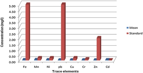
There are many ions that can be toxic to plants, either by direct up takes or by interfering with the mobility of other ions and reducing their availability to plant roots. Recommendation for maximum concentration of phototoxic elements in irrigation water was presented by the National Academy of Science as given in Table 6. Trace elements were determined in the groundwater samples in the study area to evaluate the quality of water and to identify the toxic effects of these elements.
The results of the determination of trace elements in the groundwater samples from 32 wells from Manfalut District are given in .
shows the concentrations of trace elements in the groundwater of Manfalut District. It is generally within the permissible limits for irrigation. No toxicity will arise by using water in permanent irrigation of all soil in all elements. However, the slight increase in Cadmium concentration in most of wells in the study area should be removed from groundwater. It can be done using one from these methods as aeration, sedimentation/filtration, pH adjustment, ozone or potassium permanganate oxidation with precipitation/filtration or other treatments.
In generally, the trace elements are within the permissible limits for irrigation as shown in . No toxicity will arise by using each water in permanent irrigation of all soil in Fe, Mn, Zn, Cr, Cd, Cu, Pb, and Ni elements.
8 Conclusion
This study concludes that, the main aquifer consists of medium to coarse sand and gravel formation with clay lenses in some localities from Pleistocene age. The aquifer thickness reaches to 300 m. In the west of River Nile, the groundwater level slopes gently towards the River Nile direction from level 44 m to 41 m. In the longitudinal direction, the groundwater flows from south to north from level 45 m to 44 m. The River Nile is considered as a drain for the aquifer. The TDS of groundwater in the studied area ranges from 256 in the area located near Naga Hammadi canal to 2816 ppm in the western part near desert. The chemical constituents are generally within the permissible limits for drinking and irrigation purposes.
Conflict of interest
No.
Contribution
1- This research is thus focused on: Hydrochemical Study of Groundwater and its Suitability for Different Purposes at Manfalut District, Assuit Governorate.
2- The novelty of this work is that: This paper studied the hydrogeological characteristics of groundwater aquifer at Manfalut District. Also, studied the water quality of the groundwater and its suitability for drinking and irrigation.
The research shows that, low salinity of groundwater was recorded in the area located near the canals, while high salinity was found in the western part near desert due to the diffusion of marine groundwater from Miocene aquifer.
Notes
Peer review under responsibility of National Water Research Center.
References
- H.S.AttaGroundwater Potential in Manfalut District, Assuit Governorate, Egypt. M.Sc. Thesis2014Faculty of Engineering, Cairo University
- M.Abu-ZeidMajor Policies and Programs for Irrigation Drainage and Water Resources Development in Egypt1995Water Research Center (WRC)Cairo, Egypt
- American Public Health AssociationStandard Methods for the Examination of Water and Waste Water22nd ed.2012American Public Health AssociationNew York
- S.A.AttaGroundwater hydrogeology and hydrochemistry of Sohag RegionSci. Bull. Fac. Eng. Ain Shams Univ.26December (4)19913447
- S.A.AwadEnvironmental Studies on Groundwater Pollution in Some Localities in Egypt. Ph.D. Thesis1999Faculty of Science, Cairo University
- K.A.Abdel GelilAssessment of Groundwater Potential in Wadi El Assuity, Eastern Desert-Egypt2004Annual Technical Publications, Research Institute for Groundwater, National Water Research Center
- S.A.AttaA.El morsiS.R.AwadM.M.AwadQuality of groundwater in El Minia area and impact of agricultural activitiesInternational Symposium on Desert Biome Management, Development and Improvement, Organized by Institute of African Research and StudiesDecember20044863
- M.A.DawoudN.E.El ArabiA.R.KhaterJ.WonderenImpact of rehabilitation of Assuit Barrage, Nile River, on groundwater rice in urban areasJ. Afr. Earth Sci.452006395407
- N.E.El ArabiEnvironmental impacts of desert reclamation in the Nile ValleyProceeding of the Regional Conference and International Symposium on Environmental HydrologyPublished by American Society of Civil Engineers, Egypt-Section, 10–12 October1995585594
- FAO (Food and Agriculture Organization of the United Nation), 1985. Water Quality of Agriculture. FAO Irrigation and Drainage Paper, No. 29, rev. 1, Rome.
- RIGW/IWACO, 1989. Groundwater Development for Irrigation and Drainage in the Nile Valley, Groundwater Development West El Fashn, Evaluation of Measures to Control Water Logging. March.
- RIGWHydrogeological Map of Manfalut District1994Research Institute for GroundwaterEl Kanater El Khayria, Egypt
- Soliman, S., April–October 2007. Potentiality of groundwater in the desert fringes (Case Study Mallawy, El Minia Governorate-Upper Egypt). Natl. Water Res. Center J., 41–42, 18–26.
- United States Salinity Laboratory Classification (Richard, 1954). Improvement of Saline and Alkali Soils. Agric. Hand Book No. 60, M.S. Dep. Agric., Washington, pp. 69–82.
- World Health Organization (WHO)Guidelines for Drinking Water Quality2nd ed.1998WHOGeneva, Switzerland