Abstract
Capsule Nests of Cinereous Vultures were found to be located farther from roads, villages and the edge of large vegetation patches. They preferred large vegetation patches containing extensive Cork Oak cover on steeper slopes and with lower solar radiation. Less than 8% of the study area was predicted to be suitable for nesting.
Aims To generate a predictive habitat suitability map for the Cinereous Vulture's nesting-habitat on a fine scale for conservation applications within its breeding range.
Methods Habitat features of 43 nest-locations and random points were compared in order to identify nest-habitat selected in the region of the Hornachuelos Natural Park (Spain). A logistic regression approach was used to create habitat models.
Results Compared with random points, nests were found to be located farther from roads, villages and patch edges, and in large vegetation patches containing extensive Cork Oak cover on steeper slopes with lower solar radiation. The predictive map revealed that less than 8% of the study area had a greater probability of occupancy than 0.8.
Conclusions Most habitats in the study area are unsuitable for nesting suggesting that conservation of the best suitable areas is important. The fine-scale predictive map approach may be valuable in designating conservation priority areas.
Understanding the strength of the relationships between habitat and the distribution of raptors may be important in the management of protected areas and in contributing to the development of successful conservation programmes (Limiñana et al. Citation2011, Di Vittorio et al. Citation2012). To address this, modelling of species' distributions has been increasingly used in order to identify suitable habitat and to predict potential distributions (Austin Citation2002, Rushton et al. Citation2004). Predictive habitat distribution modelling based on statistical techniques and geographic information system (GIS) tools have important potential applications, such as forecasting species occurrence in poorly documented areas, the identification of adequate target areas for species reintroduction or conservation programmes or predicting the climatic change impact (Rodríguez et al. Citation2007, Muñoz et al. Citation2013). However, there are only a few published examples of high-resolution predictive habitat distribution models (e.g. < 100-m precision) built to predict suitable nesting areas for raptors within their breeding range.
Like many birds, raptors are usually highly selective with regard to their habitats, particularly as regards the availability of suitable nesting areas (Limiñana et al. Citation2011). This is the case of the Cinereous Vulture (Aegypius monachus), a highly selective tree-nesting raptor. This raptor is considered to be an umbrella flagship species (Carrete & Donázar Citation2005) and is classified as Near Threatened in the IUCN Red List, and Vulnerable in the Spanish Red List. In the Iberian Peninsula, Cinereous Vulture populations have undergone a sharp decline, particularly throughout the first half of the 20th century, as a consequence of habitat loss and alteration, a decrease in food availability, poisoning and human disturbance (Donázar et al. Citation2002, Madroño et al. Citation2004).
Previous studies have shown that nest-site selection and occupancy by Cinereous Vultures are most likely to be affected by either loss of nests and nesting-habitat as result of human activities or disturbance during the pre-laying and laying period, particularly if these circumstances occur consistently over time (Donázar et al. Citation2002, Gavashelishvili et al. Citation2006). Consequently, the Cinereous Vulture selects its nesting-habitat in undisturbed areas, in mature vegetation patches with steep slopes (Poirazidis et al. Citation2004, Morán-López et al. Citation2006a, Moreno-Opo et al. Citation2012). The optimal habitat for Cinereous Vulture has been dramatically reduced, making its current distribution in Europe small in historical terms (Gavashelishvili et al. Citation2012), and it is thus urgent to identify and protect those suitable areas. The aim of this work is therefore to apply habitat modelling techniques with the use of a logistic regression approach and GIS tools to generate an explicative and predictive habitat suitability model for the Cinereous Vulture's nesting-habitat at a fine spatial resolution (50-m resolution) within its breeding range.
METHODS
Study area
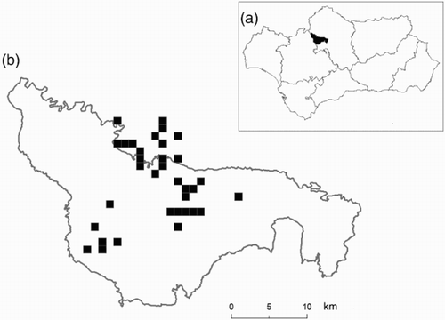
The study was conducted in Córdoba Province, in the Sierra Morena mountains (southern Spain, ) in and around the Hornachuelos Natural Park, where the Cinereous Vulture breeds currently and historically (Dobado & Arenas Citation2012). The Hornachuelos mountains were designated as a Natural Park in 1989 and cover 60 000 ha. The climate is typically Mediterranean, with moderately cool rainy winters and hot dry summers. The altitude ranges from 200 to 800 m. The dominant vegetation includes tree species such as Holm Oak (Quercus ilex) and Cork Oak (Quercus suber), reforestations of Stone Pine (Pinus pinea) and Cluster Pine (Pinus pinaster), Mediterranean scrubland dominated by Cistus spp., Erica spp., Pistacia spp., Phyllirea spp. and Rosmarinus spp and pastures areas occupied by oak savannah (dehesa). Some nests belonging to the colony are located outside the Natural Park's limits, and a 5-km conservation buffer (the maximum distance between the two nearest nests) has, therefore, been designated around them, since it is known that Cinereous Vulture usually establishes the new nests in adjacent areas to pre-existing ones. This buffer zone is included in the Guadiato-Bembézar ‘Site of Community Importance’ for the Natura 2000 network.
Figure 1. (a) The shaded area shows the location of Hornachuelos Natural Park in the region of Andalusia (southern Spain). (b) The black squares indicate the location of Cinereous Vulture nests in the study area, and the grey line is the limit of the Natural Park.
Nest survey
In 2011, the study area was searched for nest sites, and a minimum of three visits was made to every nest during the breeding season. A nest was considered to be occupied if we observed a minimum of typical pair behaviour, courtship, brood rearing activity or young (Carrete et al. Citation2001, López-López et al. Citation2006). The geographical coordinates of nests were recorded with a global positioning system. As habitat-selection studies require a comparison of the selected sites (presences) with a randomly chosen control points of non-used sites (absences) (Manly et al. Citation1993), a GIS was used to generate the same number of random points as nests, so that the number of sampled nests and the random plots was balanced (Moreno-Opo et al. Citation2012). Autocorrelation problems were reduced by constraining the random points to be at least 59-m apart (the minimum of the nearest neighbour distance of the Cinereous Vulture in the study area).
Studied variables
Those variables that affect nest-site selection by Cinereous Vultures in Spain were selected in accordance with previous studies (Morán-López et al. Citation2006a, Moreno-Opo et al. Citation2012). A total of 11 variables provided by GIS analyses were taken into account: altitude (m), slope (%), mean incident solar radiation from February to June (Wh/m2), distance to nearest road (m), distance to nearest track (m), distance to the nearest village (m), the size of the homogenous land cover patch in which the nest was located (ha), the distance from the nest/random point to the border of the vegetation patch (m) and the canopy cover covered by Q. suber (%), Quercus rotundifolia (%) and Pinus spp. (%). Topographic variables (altitude slope and solar radiation) were obtained from a digital elevation model with an accuracy of 10-m pixels of horizontal and vertical resolution, whereas vegetation variables were obtained from the third National Forestry Inventory (1997–2007) and the Corine land cover (2006). Climatic factors were not considered owing to the relatively small study area, which implies similar values of temperature, rainfall and humidity throughout the study area (Moreno-Opo et al. Citation2012).
Statistical analysis and predictive map
Univariate and multivariate statistical techniques were used to determine which factors affect the Cinereous Vulture's nest-site selection. First, Mann–Whitney U-tests were used to provide a simple description of the main differences in the mean values of the variables between nests and random sites. Secondly, a binomial logistic regression (with a logit link function), a particular case of generalised linear model, was used to identify which variables were the best predictors (Pearce & Ferrier Citation2000). Two different models were built: considering the distance to the nearest neighbour (model 1), because this variable has biological meaning and captures the spatial configuration (Barrio et al. Citation2009); and without including this spatial variable (model 2). In both cases, a forward–backward stepwise procedure was applied using the Akaike Information Criterion with a small-sample bias adjustment (AICc) to select the most parsimonious models. The accuracy of the predictive distribution models were assessed by calculating the area under the receiver operating characteristic curve (known as AUC). AUC values of > 0.7 indicate acceptable predictive power. Collinearity among continuous explanatory variables was low (Pearson correlation < 0.6; variance inflate factor < 10). The distance to the nearest nest was ln-transformed in order to eliminate nonlinearity among the independent variables and the logit of the dependent variable. Finally, Moran's I coefficient was calculated to examine spatial autocorrelation in residuals of the models in order to confirm the assumption of independent errors (Dormann et al. Citation2007).
The final models obtained by model selection were implemented in GIS using the inverse of logit transformation (Real et al. Citation2006). The predictive maps were built with a resolution of 50-m per pixel, a scale considered to represent the minimum suitable surface unit needed by the Cinereous Vulture for breeding (Poirazidis et al. Citation2004). GIS analyses were performed using ArcGIS 9.3.1 (ESRI Inc, Redlands, CA, USA) and all the statistical analysis was performed using SPSS 11 software (IBM corp. Chicago, USA).
RESULTS
In total, 43 nest-site locations were recorded in 2011, and the mean distance to the nearest neighbour was 1031 m (± 927 sd; range 59–5353 m). Nests were located farther from roads, villages and patch edges, in larger homogenous patches with high proportion of Cork Oak cover and on steeper slopes with lower solar radiation (). Both most parsimonious models showed a positive effect of slope and Cork Oak cover to the distance of vegetation patch border, and model 2 also showed a significant positive effect with the distance from the villages (). As we predicted, model 1 demonstrated an effect of the nearest nest (). Model 1 and model 2 had AUC values of 0.93 and 0.87, respectively, indicating a good discrimination capacity. Moran's I coefficient of the model with the distance to the nearest nest was particularly low, thus indicating no significant spatial autocorrelation among residuals (Moran's I = −0.007, P = 0.98), whereas the residuals of the model without this spatial variable showed spatial autocorrelation (Moran's I = −0.44, P < 0.001).
Table 1. Means (± se) of variables measured for the nests (n = 43) and the random points (n = 43).
Table 2. Logistic regression models of Cinereous Vulture habitat requirements in Hornachuelos Natural Park.
DISCUSSION
Given that the Cinereous Vulture has a long reproductive season, this species is strongly affected by anthropogenic disturbance (Madroño et al. Citation2004, Morán-López et al. Citation2006b, Margalida et al. Citation2011). Our results were in agreement with those of previous studies in that they showed that the Cinereous Vulture selected steep slope areas far away from roads, villages and from the edges of larger vegetation patches, suggesting that this species selected areas less disturbed by humans. Moreover, because the maximum temperature in the study area can reach 40°C, the thermoregulation of the young may constitute a limiting factor, and therefore, these birds tend to select areas with lower solar radiation, highlighting the importance of avoiding warmer places under these harsh conditions (Morán-López et al. Citation2006b). Lastly, some previous studies have highlighted the positive effect of extensive Cork Oak coverage, because the Cinereous Vulture selects old Cork Oaks as a preferred nesting tree, because they can support the weight of nests and are easier to land on and take off from (Donázar et al. Citation2002, Moreno-Opo et al. Citation2012).
Since this study was carried out inside the limits of a current and historical breeding area for the Cinereous Vulture, the effects of anthropogenic disturbance were likely to be uniformly weak () in contrast to other areas where they are an important predictor (Morán-López et al. Citation2006a), thus the results should be interpreted in this context. Therefore, although distance from tracks and roads to the nest was not a very important negative predictor, road access is restricted in many areas of the study area, and the roads which cross the study area are secondary roads with little car transit. In the same way, since the study area has low human population density, the distance from villages between occupied and unoccupied areas is also less marked ().
With regard to habitat nest-selection for colonial or semi-colonial raptor species, conspecific attraction may play an important role in breeding spatial distribution (Sergio & Penteriani Citation2005, Limiñana et al. Citation2011). Indeed, the first model confirmed that the proximity to the nearest nest was an important predictor in determining nest-location, and therefore, most of the predicted suitable areas were located surrounding pre-existing vulture nests (a). Moreover, this model had a higher AUC value, lower AICc value and no spatial autocorrelation among residuals, thus suggesting that the aggregated spatial pattern of the nests should be considered in any predictive model for Cinereous Vulture. Model 2 can also be considered for predicting the spread of the colony in the long term, because this model allows the identification of places far away from the current existing nests (b). However, in the light of the aforementioned reasons, we believe that the model that included the distance to the nearest nest is more appropriate, particularly in order to predict the immediate colonization of new territories. Therefore, for this semi-colonial species, increasing the availability of preferred habitats in the periphery of the existing nests might be more efficient in ensuring the occupancy of given areas when designing areas for conservation priority.
Figure 2. Probability of presence of Cinereous Vultures derived from logistic regression at a 50 × 50 m resolution taken into account the distance from the nearest nest (a) or without this variable (b).
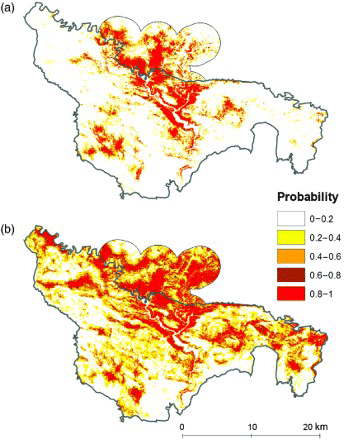
Predictive species distribution models have been used in a wide range of applications including regional biodiversity assessments, conservation biology, wildlife management and conservation planning (Rodríguez et al. Citation2007). However, the lack of fine-grain predictive maps may result in their low effectiveness for designing further protected areas (López-López et al. Citation2007, Fernández & Gurrutxaga Citation2010). In the light of these considerations, our predictive maps may be valuable for the local management of the Cinereous Vulture. For instance, here we have shown that many favourable areas are situated outside the protected limits of the Natural Park, but are inside the Guadiato-Bembézar ‘Site of Community Importance’ for the Natura 2000 network (). In these conservation priority areas for the Cinereous Vulture, the implementation of spatial and temporal buffer zones around potentially sensitive areas (breeding sites) where disturbances are limited or prohibited (Margalida et al. Citation2011), and the preservation of large vegetation patches with extensive coverage of Cork Oak should favour the establishment of new breeding pairs. Lastly, the probability maps may also be very helpful in identifying sites for the construction of artificial nests, although microhabitat variables such as tree species and tree height would be necessary to select the exact sites for these.
The Cinereous Vulture can be considered as an habitat indicator species owing to its nest-site selection in areas with high conservation status that are important to many other species (Moreno-Opo et al. Citation2012). The predictive map that included the distance to the nearest neighbour also revealed that less than 8% of the study area had a higher probability value of occupancy than 0.8 (a), which can be considered a reasonable threshold value, because the odds are higher than 4:1 (Real et al. Citation2006). These low values of suitable habitat inside the breeding range imply that the conservation of these best suitable areas is a major concern in order to minimize the negative impact of habitat loss. The scale used in our experiment (50-m resolution) permits the delimitation of protection areas in which the occurrence of target species is more probable, thus allowing the application of fine-scale management decisions.
ACKNOWLEDGEMENTS
A. monachus nesting population in the Hornachuelos colony was surveyed with the aid of staff from the Andalusia Environmental Agency. We would first like to express our gratitude to the staff from Andalusia Environmental Government for collecting the data, particularly to Pablo M. Dobado. We would also like to thank I.C. Barrio and A.J. Carpio and for their useful comments and suggestions, and S. Crespo for her support.
FUNDING
This work is funded by the Andalusia Environmental Government through a project for the conservation of the Cinereous Vulture in Cordoba Province.
REFERENCES
- Austin, M.P. 2002. Spatial prediction of species distribution: an interface between ecological theory and statistical modelling. Ecol. Model. 157: 101–118. doi: 10.1016/S0304-3800(02)00205-3
- Barrio, I.C., Bueno, C.G. & Tortosa, F.S. 2009. Improving predictions of the location and use of warrens in sensitive rabbit populations. Anim. Conserv. 12: 426–433. doi: 10.1111/j.1469-1795.2009.00268.x
- Carrete, M. & Donázar, J.A. 2005. Application of central-place foraging theory shows the importance of Mediterranean dehesas for the conservation of the cinereous vulture, Aegypius monachus. Biol. Conserv. 126: 582–590. doi: 10.1016/j.biocon.2005.06.031
- Carrete, M., Sánchez-Zapata, J.A., Martínez, J.E., Palazón, J.A. & Calvo, J.F. 2001. Distribución espacial del Águila Azor-Perdicera (Hieraaetus fasciatus) y del Águila Real (Aquila Chrysaetos) en la región de Murcia. Ardeola 48: 175–182.
- Di Vittorio, M., Maurizio, S. & López-López, P. 2012. Habitat preferences of Bonelli's Eagles Aquila fasciata in Sicily. Bird Study 59: 207–217. doi: 10.1080/00063657.2012.656577
- Dobado, P.M. & Arenas, R. 2012. (coords) The Black Vulture: Status, Conservation and Studies. Consejería de Medio Ambiente, Junta de Andalucia, Córdoba.
- Donázar, J.A., Blanco, G., Hiraldo, F., Soto-Largo, E. & Oria, J. 2002. Effects of forestry and other land-use practices on the conservation of cinereous vultures. Ecol. Appl. 12: 1445–1456. doi: 10.1890/1051-0761(2002)012[1445:EOFAOL]2.0.CO;2
- Dormann, C.F., McPherson, J.M., Araujo, M.B., Bivand, R., Bolliger, J., Carl, G., Davis, R., Hirzel, A., Jetz, W., Kissling, W.D., Kühn, I., Ohlemüller, R., Peres-Neto, P.R., Reineking, B., Schröder, B., Schurr, F.M., & Wilson, R. 2007. Methods to account for spatial autocorrelation in the analysis of species distributional data: a review. Ecography 30: 609–628. doi: 10.1111/j.2007.0906-7590.05171.x
- Fernández, J.M. & Gurrutxaga, M. 2010. Habitat suitability models for assessing bird conservation goals in special protection areas. Ardeola 57: 79–91.
- Gavashelishvili, A., Mcgrady, M.J. & Javakhishvili, Z. 2006. Planning the conservation of the breeding population of cinereous vultures Aegypius monachus in the Republic of Georgia. Oryx 40: 76–83. doi: 10.1017/S0030605306000081
- Gavashelishvili, A., McGrady, M., Ghasabian, M. & Bildstein, K.L. 2012. Movements and habitat use by immature cinereous vultures (Aegypius monachus) from the Caucasus. Bird Study 59: 449–462. doi: 10.1080/00063657.2012.728194
- Limiñana, R., Arroyo, B.E., Surroca, M., Urios, V. & Reig-Ferrer, A. 2011. Influence of habitat on nest location and reproductive output of Montagu's Harriers breeding in natural vegetation. J. Ornithol. 152: 557–565. doi: 10.1007/s10336-010-0615-8
- López-López, P., García-Ripollés, C., Aguilar, J.M., García-López, F. & Verdejo, J. 2006. Modelling breeding habitat preferences of Bonelli's eagle (Hieraaetus fasciatus) in relation to topography, disturbance, climate and land use at different spatial scales. J. Ornithol. 147: 97–106. doi: 10.1007/s10336-005-0019-3
- López-López, P., García-Ripollés, C., Soutullo, A., Cadahía, L. & Urios, V. 2007. Are important bird areas and special protected areas enough for conservation? The case of Bonelli's eagle in a Mediterranean area. Biodivers. Conserv. 16: 3755–3780. doi: 10.1007/s10531-007-9179-1
- Madroño, A., González, C. & Atienza, J.C. (eds) 2004. Libro Rojo de las Aves de España. Dirección General para la Biodiversidad SEO/Bird Life, Madrid.
- Manly, B.F.J., Mcdonald, L.L. & Thomas, D.L. 1993. Resources Selection by Animals. Statistical Design and Analysis for Field Studies. Springer, London.
- Margalida, A., Moreno-Opo, R., Arroyo, B.E. & Arredondo, A. 2011. Reconciling the conservation of endangered species with economically important anthropogenic activities: interactions between cork exploitation and the cinereous vulture in Spain. Anim. Conserv. 14: 167–174. doi: 10.1111/j.1469-1795.2010.00412.x
- Morán-López, R., Sánchez, J.M., Costillo, E. & Villegas, A. 2006a. Nest-site selection of endangered cinereous vulture (Aegypius monachus) populations affected by anthropogenic disturbance: present and future conservation implications. Anim. Conserv. 9: 29–37. doi: 10.1111/j.1469-1795.2005.00003.x
- Morán-López, R., Sanchez, J.M., Costillo, E., Corbacho, C. & Villegas, A. 2006b. Spatial variation in anthropic and natural factors regulating the breeding success of the cinereous vulture (Aegypius monachus) in the SW Iberian Peninsula. Biol. Conserv. 130: 169–182. doi: 10.1016/j.biocon.2005.12.011
- Moreno-Opo, R., Fernández-Olalla, M., Margalida, A., Arredondo, Á. & Guil, F. 2012. Effect of methodological and ecological approaches on heterogeneity of nest-site selection of a long-lived vulture. PLoS ONE 7: e33469. doi: 10.1371/journal.pone.0033469
- Muñoz, A.-R., Márquez, A.L. & Real, R. 2013. Updating known distribution models for forecasting climate change impact on endangered species. PLoS ONE 8: e65462. doi: 10.1371/journal.pone.0065462
- Pearce, J. & Ferrier, S. 2000. Evaluating the predictive performance of habitat models developed using logistic regression. Ecol. Model. 133: 225–245. doi: 10.1016/S0304-3800(00)00322-7
- Poirazidis, K., Goutner, V., Skartsi, T. & Stamou, G. 2004. Modelling nesting habitat as a conservation tool for the Eurasian black vulture (Aegypius monachus) in Dadia Nature Reserve, northeastern Greece. Biol. Conserv. 118: 235–248. doi: 10.1016/j.biocon.2003.08.016
- Real, R., Barbosa, A.M. & Vargas, J.M. 2006. Obtaining environmental favourability functions from logistic regression. Environ. Ecol. Stat. 13: 237–245. doi: 10.1007/s10651-005-0003-3
- Rodríguez, J.P., Brotons, L., Bustamante, J. & Seoane, J. 2007. The application of predictive modelling of species distribution to biodiversity conservation. Divers. Distrib. 13: 243–251. doi: 10.1111/j.1472-4642.2007.00356.x
- Rushton, S.P., Ormerod, S.J. & Kerby, G. 2004. New paradigms for modelling species distributions? J. Appl. Ecol. 41: 193–200. doi: 10.1111/j.0021-8901.2004.00903.x
- Sergio, F. & Penteriani, V. 2005. Public information and territory establishment in a loosely colonial raptor. Ecology 86: 340–346. doi: 10.1890/04-0137