
If maps serve to clarify the role of space and place in the human journey, maps created for providing observations of topography – the shape and character of the Earth's surface – were amongst the first to be made. They symbolized landscapes long before the introduction of scientific methods to cartography, when the idea of drawing to a fixed scale revolutionized topographical mapping in the sixteenth century (Harvey, Citation1980: 14). Topographic maps thereafter became increasingly useful tools for exploring, understanding, and controlling the environment, with, for example, the systematic Carte Géometrique de la France prepared by different generations of the Cassini family at a scale of 1:86 400 from 1750 to 1815, serving as a model and inspiration for other European states (Hodgkiss, Citation1981: 170). The relevance of topographic information provided the motivation for many initiatives in state map-making, particularly for military and cadastral purposes. Gradually, methods of survey developed to incorporate photogrammetry and cartographic production improved with colour lithographic printing to enable topographic maps to be regarded as the ‘supreme achievement of the modern age of cartography’ (Jervis, Citation1936: 171).
Today, topographic maps maintain their unique position of authority amongst cartographic products. This authority is, of course, in part derived from the apparent scientific accuracy with which symbols on the map correspond to features in the real world, but is also a reflection of state authorship and production. Governmental organizations, such as the military and/or National Mapping and Cadastral Agencies (NMCAs), are usually responsible for maintaining the complete and detailed topographic mapping of national territory. This includes ensuring that standards of cartographic accuracy are upheld in their portrayal of natural and cultural features, such as relief, water, vegetation, transportation, urban areas, and toponomy. National topographic map series store and offer topographic information from large to small scales and provide a spatial reference framework for other data about the Earth and its resources. They serve multiple purposes, such as infrastructure planning and management, resource, exploitation, demographic analysis, recreational activities, and military planning. Topographic map series have a nationally consistent range of map scales, geodetic base information (e.g. ellipsoid and height datum), projection, symbology, content, and sheet design. Due to their comprehensive description of the landscape and the wide range of uses and users, topographic maps are highly complex maps with numerous map features related to each other (Robinson et al., Citation1995; Bollmann et al., Citation2002; Vereshchaka Citation2002; Buckley et al., Citation2005). Nevertheless, topographic maps are just as likely to be admired in artwork that explores space and place ex situ () as they are to be used for the multitude of purposes they are intended to serve in situ.
Figure 1. Detail from Snowdon (Yr Wyddfa) West Sheet (Taflen y Gorliewin) (2018), tempera on map paper (126×94 cm), by Uwe Walther (reproduced courtesy of the artist and the John Martin Gallery).
The growth and use of GIS have fundamentally changed the cartographic production technology of topographic maps as well as their use. To meet these increasing demands, NMCAs have established national topographic databases based on their traditional topographic map series. The content of topographic maps evolved into topographic reference data that were structured into themes and feature types. These databases provide seamless, object-structured reference data on the national level to be used in NSDI (National Spatial Data Infrastructure) services, in GIS applications for spatial analysis and modelling, and to generate cartographic products. Nevertheless, a pressing issue, raised by Morrison (Citation2006: 10) about the future of cartography, concerns the inevitable delay that is initiated by new technologies between user expectations and the capability to deliver these associated products. New display technologies raise the expectation that one day it will no longer be necessary to establish different design concepts for different output media. Some believe that the development of a large, flexible, and portable display, with increased graphic capabilities and a pixel size comparable to the resolution of a printed paper map, may eventually lead to the final replacement of the printed topographic map (Hopfstock, Citation2010: 146).
Until web map servers gathered pace in the first decade of the new millennium, topographic maps were often the most common form of detailed mapping available. Growth in the mapping initiatives of technology giants, such as Apple Maps, Bing (Microsoft) and Google Maps, and the dramatic success of OpenStreetMap (OSM) since its foundation in 2004 – from a user-generated source of digital mapping to a global counter map – began to challenge the long-held position of NMCAs as the exclusive and official providers of national topographic mapping products. Moving beyond the initial perspective of mutual competition, today many NMCAs have a different view and in many cases OSM and NMCAs have begun to exchange information; NMCA data are integrated into OSM making it more reliable, while OSM provides crowd-sourced updates and additional content for the NMCAs. Mapping from the private sector also relies on geodata from the NMCAs as they purchase national mapping products and develop them further according to their needs (even if this is often a one-way transaction, since national mapping products are often bought once; updates and changes are undertaken by the private companies themselves). The major challenges for NMCAs are to manage resources (time, trained cartographers, budget) effectively, to adapt to new technologies, to develop flexible mapping products that are required by a growing diversity of users and applications, and to manage competition from products developed by the private sector.
Overall, the unique status of topographic maps is derived from the high degree of trust that users place in them and from their enduring relevance to society. They tend to be regarded as authoritative, objective and truthful representations due to their long tradition of scientific survey and institutionalised production, but they are also seen as cultural objects (Grothenn, Citation1994) and national treasures (Lilley, Citation2009). Indeed, stylistic diversity in the cartography of topographic maps produced by different nations demonstrates that aesthetics and national identity play just as important a role in their formation as cultural artefacts as their scientific value (Kent and Vujakovic, Citation2009, Citation2011; Ory et al., Citation2015). More recently, greater insights into the true scope of the Soviet global topographic mapping programme are coming to light (e.g. Davies and Kent, Citation2017), proving that regardless of the contrasting contexts of their production and their real and imagined uses, topographic maps have an enduring appeal that transcends time, space and culture. Perhaps no other type of map simultaneously interweaves art and science, inspires wonder in both its cartography and its subject, and generates the desire to engage in counter-mapping, than the topographic map – this hymn to the national landscape.
The papers in this Special Issue bring together different perspectives on topographic mapping. They highlight rich national and regional traditions by examining their history, describe how topographic mapping is embracing current technologies and point to some challenges of the future. The first paper, by Beata Medyńska-Gulij and Tadeusz Żuchowski, provides a well-illustrated investigation into the implementation of different drawing techniques when topographic surveys were increasingly being undertaken by European powers during the Enlightenment. This is followed by Mirela Altić’s contribution, which focuses on the design and production of Ottoman topographic maps in the nineteenth century and describes how the topographic maps produced by foreign states influenced the design and production of the Ottoman sheets left a stylistic legacy. The focus of this Special Issue then shifts towards techniques employed in topographic mapping, from the automation of relief and rock hachures in Switzerland, discussed by Geisthövel and Hurni, to new symbology for portraying urban areas in Brazil, by Claudia Robbi Sluter and her colleagues. The final two papers address current and future technologies associated with topographic mapping. The first, by E. Lynn Usery and his colleagues at USGS, explains how a new form of topographic map is being created where the Semantic Web and Linked Open Data allow the map to become an interactive, linked knowledge base. This is followed by a foray into the potential use of Virtual Reality in topographic mapping provided by Łukasz Halik, which raises pertinent questions about the development of new products in this area. We are very grateful to all our authors for responding to our call for papers and for submitting their manuscripts on time.
Reflecting on the past year, as is customary for the final instalment of The Cartographic Journal in each Volume, this has seen the flagship publication of the BCS continue to advance in several ways. Issue 55.1 saw the introduction of the new page layout and design, while both the Journal's impact factor and the number of manuscript submissions have increased (reaching their highest yet). I should therefore like to thank all those who have played a role in supporting the Journal, especially our reviewers, who have freely given their time and expertise to ensure that we maintain our standards in publishing the best cartographic research. I am enormously grateful to be able to count on the Journal's Associate Editors, Peter Vujakovic and Gwilym Eades, for their ongoing commitment to quality, and to Martin Davis, the Editorial Assistant, who continues to raise the book and atlas reviews to a new level. Sincere thanks are also due to all those who serve on the editorial board and have generously shared their wisdom in shaping the design and content of the Journal this year. Last, but by no means least, the team at Taylor & Francis (Carolina Bergfors, Prempriya Mohan, Eilise Norris and Matt Cannon) have never failed to provide their inimitable blend of patience and professionalism, which thoroughly deserves our appreciation. Earlier this year, the cartographic community were saddened to learn of the deaths of Waldo Tobler and Ann Sutherland. Waldo was known to many around the world for his pioneering contributions to cartography and quantitative geography (obituary on pp.303–304) and Ann was an ardent champion of map curatorship, whose presence at BCS Council meetings will be missed (obituary on pp.405–406). As is also customary for this time of year, this Special Issue includes the Society's Annual Report and a summary of the Society's awards for 2018.
Notes on the cover
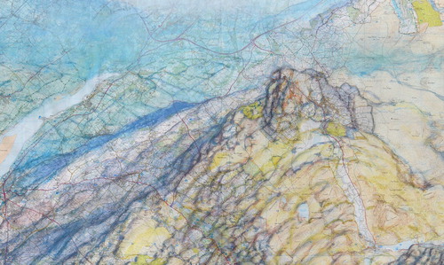
The cover image is an extract from Mürren Finsteraarhorn (2016) by Uwe Walther. The artist's parents were cartographers in the former East Germany, and Uwe (who is also a keen mountaineer), became fascinated with the technical and aesthetic beauty of the 1:25 000 Swiss national topographic maps when he moved to Switzerland 30 years ago. The maps provide a framework for the artist's subtle interventions in which new perspectives are conjured out of the contour lines of the printed page. As Uwe explains:
The idea at the heart of my map paintings is quite simple: every map contains different information about the territory that it represents (the location of streets, forests, water, villages, as well as the altitude of the ground, and so on). When you study a map, this is the information that helps you visualize the landscape. This is exactly what I do with my pictures: I read a map then I put it into the cinema of my mind and I imagine how the terrain might appear. In doing so, I transfer the objective, technical and scientific elements of a territory, approved and published by the state, into a subjective idea of a landscape.
Notes on the contributors
 Alexander J. Kent is Reader in Cartography and Geographic Information Science at Canterbury Christ Church University in the UK, where he lectures on map design, GIS, remote sensing and on European and political geography. His research explores the relationship between maps and society, particularly the intercultural aspects of topographic map design and the aesthetics of cartography. Alex is also the Immediate Past President of the BCS and Chair of the ICA Commission on Topographic Mapping.
 Anja Hopfstock is Head of the German SDI Coordination Office at the Federal Agency for Cartography and Geodesy, Germany. She has been deeply involved in several international projects dealing with cross-border harmonization of topographic and cadastral reference data. She is active in the German Cartographic Association and as Vice-Chair of the ICA Commission on Topographic mapping.
References
- Bollmann, J., Lipinski, A. and Koch, W.G. (Eds) (2001, 2002) Lexikon der Kartographie und Geomatik (2 vols) Heidelberg: Spektrum Akademischer Verlag.
- Buckley, A., Frye, C. and Buttenfield, B. (2005) “An Information Model for Maps: Towards Cartographic Production from GIS Databases” Proceedings of the 22nd International Cartographic Conference (ICC) A Coruña: Global Congresos.
- Davies, J. and Kent, A.J. (2017) The Red Atlas Chicago: University of Chicago Press.
- Grothenn, D. (1994) “Einheitliche Gestaltung der amtlichen topographischen Kartenwerke in Europa?” Kartographische Nachrichten 44 (1) pp. 1–6.
- Harvey, P.D.A. (1980) The History of Topographical Maps: Symbols, Pictures and Surveys London: Thames & Hudson.
- Hodgkiss, A.G. (1981) Understanding Maps: A Systematic History of Their Use and Development Folkestone: Wm Dawson & Son.
- Hopfstock, A. (2010). “A user oriented map design in the SDI environment-using the example of a European Reference Map at medium scale.” Technische Universität Dresden (PhD thesis) Available at: http://nbn-resolving.de/urn:nbn:de:bsz:14-qucosa-71981 (Accessed 28th January 2019).
- Jervis, W.W. (1936) The World in Maps: A Study in Map Evolution London: George Philip & Son.
- Kent, A.J. (2009) “Topographic Maps: Methodological Approaches for Analyzing Cartographic Style” Journal of Map and Geography Libraries 5 (2) pp.131–156. doi: 10.1080/15420350903001187
- Kent, A.J. and Vujakovic, P. (2009) “Stylistic Diversity in European State 1:50 000 Topographic Maps” The Cartographic Journal 46 (3) pp.179–213. doi: 10.1179/000870409X12488753453453
- Kent, A.J. and Vujakovic, P. (2011) “Cartographic Language: Towards a New Paradigm for Understanding Stylistic Diversity in Topographic Maps” The Cartographic Journal 48 (1) pp.21–40. doi: 10.1179/1743277411Y.0000000004
- Lilley, R.J. (2009) “Cartographic Renaissance at Ordnance Survey (GB)” In: Proceedings of the ICA Symposium on Cartography for Central and Eastern Europe, pp.51–66.
- Morrison, J. L. (2006) “Whither Where? Remarks on the Future of our Profession” In: Kriz, K., Cartwright, W., Pucher, A. and Kinberger, M. (Eds) Wiener Schriften zur Geographie und. Kartographie: Vol. 17. Kartographie als Kommunikationsmedium. Vienna: Inst. Für Geographie und Regionalforschung der Univ. Kartographie und Geoinformation.
- Ory, J., Christophe, S., Fabrikant, S.I. and Bucher, B. (2015) “How to Map Readers Recognize a Topographic Mapping Style?” The Cartographic Journal 52 (2) pp.193–203. doi: 10.1080/00087041.2015.1119459
- Robinson, A.H., Morrison, J.L., Muehrcke, P.C., Kimerling, A.J. and Guptill, S.C. (1995) Elements of Cartography (6th ed.) New York: John Wiley & Sons.
- Vereshchaka, T.V. (2002) Topograficheskie karty: Nauchnye osnovy soderzhaniëiìa [Topographic Maps: The Scientific Principles of their Content] Moscow: MAIK Nauka/Interperiodika.