
27th May 1927 to 15th November 2019
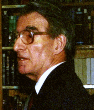
After graduating from Cambridge, John Harwood Andrews joined the geography department at Trinity College, Dublin in 1954, from which he retired as Associate Professor in 1990. He is best known as the leading historian of the mapping of Ireland, and particularly for his work on the Ordnance Survey. History in the Ordnance Map (Citation1974) and A Paper Landscape: The Ordnance Survey in Nineteenth-century Ireland (Citation1975) are both models of style, and Shapes of Ireland: Maps and their Makers 1564–1839 (Citation1997) is a history of the development of topographic mapping of the island up to the arrival of the Ordnance Survey.
In the 1960s and 1970s, Andrews was influenced particularly by R.A. Skelton (who died in 1970) and by Brian Harley, but after the early 1980s, their paths diverged: Harley pursued a method that used theory derived from writers such as Foucault and Derrida, whereas Andrews continued to be more straightforwardly empirical, explaining developments by reference to practical needs and the realities of the situation. He was particularly concerned with Harley's defining maps in social terms, rather than as primarily practical tools. The spread of Harley's ideas was not impeded by his premature death in 1991; Andrews published several papers arguing for a less theory-dependent approach, but seemed to be battling against the tide. Andrews certainly found Harley stimulating, and it is a measure of his fair-mindedness that a version of one of Andrews’ papers appears as the introduction to Harley's essay collection The New Nature of Maps (Citation2001). Andrews was very much his own man; one had the impression that this was shaped partly by the relative isolation of working in Dublin, though there was also unquestionably his considerable intellect. As he explained in the preface to the 2002 reissue of A Paper Landscape, he was also influenced by a current of ‘value-free historiography’, ‘judicious […] and apparently designed to prevent readers from deducing which church an author worshipped in, which flag he pledged allegiance to, or which party he voted for’.
Andrews’ approach was also certainly stimulated by the appearance in Citation1981 of Brian Friel's play Translations. The play implied that the Ordnance Survey's name-recording process in Ireland was an imposition of outside values, and many have taken it as a rather closer approximation to historical truth than the record justifies. Andrews sought to counter this, with several seminar papers and publications, but was obliged to concede that Friel appeared to be gaining the greater circulation.
The question of how far either Harley or Andrews was justified in the debate about theory and the social construction of maps is not one that can be pursued here, but it had the material consequence of Andrews’ final book, Maps in Those Days: Cartographic Methods before 1850 (Citation2009). It can be read on two levels: as a manual of technical processes, from geodesy right through to the finished map, in manuscript or in print; and as an implied final counterblast to the ‘Harley school’: the overall implication is that maps as we see them are framed by practical considerations.
John Andrews must rank amongst the most readable of cartographic historians and commentators, and many of us have enjoyed his writing and been inspired by his style. When I last met him, he told me that he did not ‘enjoy’ writing: this should come as no surprise, as such facility is the product of thought and polishing as well as spontaneity and reasoning. (It is telling that the preface to A Paper Landscape is dated ‘October 1970–April 1974’.) Not the least of his contributions was to set a high standard for expressing what was to be said about maps.
References
- Andrews, J.H. (1974) History in the Ordnance Map Dublin: The Ordnance Survey Office.
- Andrews, J.H. (1975) A Paper Landscape: The Ordnance Survey in Nineteenth-Century Ireland Oxford: Oxford University Press.
- Andrews, J.H. (1997) Shapes of Ireland: Maps and their Makers 1564–1839 Dublin: Geography Publications.
- Andrews, J.H. (2001) “Introduction: Meaning, Knowledge, and Power in the Map Philosophy of J.B. Harley” In Harley, J.B. and Laxton, P. (Eds) The New Nature of Maps: Essays in the History of Cartography Baltimore, MD: The Johns Hopkins University Press, pp.1–32.
- Andrews, J.H. (2009) Maps in Those Days: Cartographic Methods before 1850 Dublin: Four Courts Press.
- Friel, B. (1981) Translations London: Faber and Faber.