Site details
The Lake Orestiás is situated in the Kastoria Basin, northern Greece (40° 30′ 42″ N, 21° 15′ 28″ E; 630 m a.s.l.; size: 3240 ha) and is surrounded by the Trikalario (1749 m), Verno (2128 m) and Askion (1703 m) mountains. It has a maximum depth of 9.1 m in the northern part of the lake, while its mean depth is 4.5 m. Several streams discharge into the northern, western and eastern part of the lake. The overflow then discharges into the Aliakmon River through the Gioli Channel in the south. The vegetation of the Kastoria Basin is diverse. Cultivated land and pasture comprises 44% of the catchment area, mainly in the lower elevations. In hilly areas, mixed deciduous oak forests intersperse with open shrubby vegetation and stands of chestnut, while beech and coniferous forests occur in the mountainous areas around Mount Vermo. The climate is characterised as semi-humid to humid with moderate dry summers (C2s B1b3 type according to Thornthwaite; Karras, Citation1973). The mean annual temperature is 12.5 °C while the mean annual precipitation is 591.7 mm showing a double fluctuation within the year (maxima in May and December; Balafoutis, Citation1977). The Kastoria Basin has apparently been settled by humans continuously since the Neolithic. The settlement Dispilió at the southern shore of the Lake Orestiás is of Middle Neolithic to Early Bronze Age (c. 5500–3500 bc) and has been excavated for the last decade (Hourmouziadis, Citation2002).
Sediment description
A 550 cm core was recovered in 1996 from the western part of the Lake Orestiás about 1 km south of the city of Kastoria. The composition was as described below:
0–200 cm: dark olive grey silt
200–300 cm: olive silt
300–325 cm: olive grey very fine sand
325–335 cm: olive grey silt with mollusc fragments
335–360 cm: dark grey silt
360–445 cm: dark grey fine sand with mollusc fragments
445–485 cm: dark grey silt with mollusc fragments
485–490 cm: light grey fine sand with mollusc fragments
490–495 cm: light grey silt
495–505 cm: laminated silt
505–540 cm: grey to olive grey silt
540–550 cm: very dark grey fine sand
Dating
AMS 14C dating was performed on Pinus pollen grains, in the AMS C14-Laboratory Erlangen, University of Erlangen, Germany. Dating results are as follows:
75 cm: 1931 ± 524 years cal. bp (Pto 2516, Erl‐2290)
110 cm: 4687 ± 155 years cal. bp (Pto 2573, Erl‐2444)
242 cm: 7246 ± 364 years cal. bp (Pto 2373, Erl‐2291)
Interpretation
The pollen percentage diagram () is based on a pollen sum of more than 300 terrestrial pollen and spores, excluding pollen and spores of aquatic plants and Cyperaceae.
Figure 1. Percentage pollen diagram from Lake Orestiás. The diagram is based on a pollen sum of more than 300 terrestrial pollen and spores, excluding pollen and spores of aquatic plants and Cyperaceae.
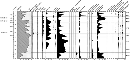
Zone KA-W1 (550–485 cm): Pollen assemblage is characterised by the dominance of Poaceae, Chenopodiaceae and Asteraceae, implying open steppe vegetation for the area during the Late glacial. Nevertheless, the minor presence of Quercus, Pinus, Ulmus, Carpinus/Ostrya type and Juniperus indicates the occurrence of restricted forests in favourable areas (Bennett et al., Citation1991).
Zone KA-W2 (485–405 cm): Pinus values increase rapidly reflecting the early expansion of coniferous forests observed in certain Greek sites of intermediate altitude (Bottema, Citation1974, Citation1979; Digerfeldt et al., Citation2000), just before the beginning of the Holocene.
Zone KA-X (405–300 cm): The rapid expansion of Quercusis indicative of the establishment of open deciduous forests at intermediate altitudes as a response to the climatic amelioration at the onset of the Holocene.
Zone KA-Ya (300–262 cm): An expansion of conifer forests characterises the beginning of this zone. After an abrupt reduction at the base of the zone, Quercus values increase gradually, together with the Carpinus/Ostrya type and Fagus. The sharply reduced abundance of the light-demanding Sanguisorba minor type indicates a closure of the deciduous forests.
Zone KA-Di (262–132 cm): Human impact on the natural vegetation, as a result of establishment of the Dispilió lake settlement, is inferred from the fluctuations of the AP:NAP ratio and by the presence of anthropogenic pollen indicators (Kouli & Dermitzakis, Citation2008).
Zone KA-Yb (132–100 cm): The increase in the abundances of Quercus, Fagus, Abies and the decrease in Poaceae and Cerelia-type coincides with the abandonment of the lake settlement and the displacement of the centre of human activity from the lake shore.
Zone KA-Z1 (100–60 cm): A sharp decline in AP is recorded. Quercus, Pinus and Abies values decrease, while pollen percentage values of Fagus, the Carpinus/Ostrya type and Juglans are stable. Poaceae reach their maximum values.
Zone KA-Z2 (60–27 cm): Further decrease in Quercus pollen values are accompanied by a decrease in Fagus, the Carpinus/Ostrya type and Poaceae. Pinus pollen values increase gradually.
Zone KA-Z3 (27–0 cm): In the upper zone, most arboreal pollen types are of limited presence. Quercus recovers with regard to the previous zone, though its values remain low. Poaceae, Asteraceae and Chenopodiaceae values point to an open landscape in the surroundings of the lake.
Acknowledgements
The investigation was supported by the programme PEND-95-ED-1983, co-funded by the European Union, and the General Secretary of Research and Technology of Greece. Prof. Dr J. F. W. Negendank and Prof. Dr T. Litt are thanked for the 14C dating.
Related Research Data
References
- Balafoutis , C. 1977 . Contribution to the study of the climate of Makedonia and west Thrace , Thessaloniki, , In Greek : Aristotle University of Thessaloniki, PhD Diss .
- Bennett , K. D. , Tzedakis , P. C. and Willis , K. J. 1991 . Quaternary refugia of north European trees . Journal of Biogeography , 18 : 103 – 115 .
- Bottema , S. 1974 . Late Quaternary vegetation history of northwestern Greece , Groningen : Rijksuniversiteit Groningen, PhD Diss .
- Bottema , S. 1979 . Pollen analytical investigations in Thessaly (Greece) . Palaeohistoria , 21 : 19 – 40 .
- Digerfeldt , G. , Olsson , S. and Sandgren , P. 2000 . Reconstruction of lake-level changes in lake Xinias, central Greece, during the last 40 000 years . Palaeogeography, Palaeoclimatology, Palaeoecology , 158 : 65 – 82 .
- Hourmouziadis , G. 2002 . Dispilió 7 500 years after , Thessaloniki : University Studio Press (In Greek with English summary) .
- Karras , G. 1973 . Climatic classification of Greece according to , In Greek : Thornthwaite. Athens: University of Athens, PhD Diss .
- Kouli , K. and Dermitzakis , M. D. 2008 . Natural and cultural landscape of the Neolithic settlement of Dispilió: palynological results . Hellenic Journal of Geosciences , 43 : 29 – 39 .