Prior to the introduction of the cross staff by the Portuguese about 1514, the only method of taking an altitude of a celestial body at sea was by use of the astrolabe or derivatives of it like the quadrant.
The astrolabe was developed prior to the Christian era in classical Greece as an instrument for measuring altitudes and calculating sunrise and sunset, and is mentioned by Ptolemy. Its principal use from early times was in astronomy. However, it was during the phase of Islamic scientific development that it became refined and by about ad 800 it had achieved a high degree of accuracy. Islam had a keen interest in astronomy as a means of calculating prayer times and finding the direction of Mecca. The instrument arrived in Europe via Spain where it was introduced by the Islamic invaders. But it was the need to define a vessel's position at sea, which became more urgent as the European exploration of the world commenced in the fifteenth and sixteenth centuries that led to a simpler form of the astrolabe being introduced for maritime navigators. This was known as the mariner's or sea astrolabe whose sole purpose was to measure altitudes of celestial bodies at sea.
The mariner's astrolabe is a simple disc, made of brass, calibrated around the rim in degrees. Attached by a pin through the dead centre of this disc is the alidade, a narrow plate with pointers and two upright perpendicular plates called vanes at each end. In each of these vanes are a small hole and these holes align with the pointers. To read the altitude of a chosen body the observer looks through these two small holes at the body and then reads off the altitude from the pointers on the calibrated scale. To ensure that the astrolabe is vertical, it is held by a swivelled suspension ring at the top which allowed the instrument to swing as a vessel rolled or pitched. To provide greater steadiness on a rolling and pitching deck, the instruments were usually solid and quite heavy, but even this weight would not hold the instrument steady in strong winds. Obviously the larger the instruments, the bigger the gaps between the degree marks at the circumference, and the easier the instrument would be to read, but there was a practical limit to the weight that could be comfortably suspended by the fingers and the windage, which, if it was too large, could make the instrument unsteady. In practice most mariner's astrolabes are about 150 mm in diameter which makes each degree at the circumference about a millimetre. This appears very small, but in practice it is possible to divide this roughly into quarters which would create an error within 15 minutes of latitude, or fifteen nautical miles.
The quadrant, also originally suggested by Ptolemy, was certainly in use by Arabian astronomers by the ninth century. A simple version consists of a semicircular plate, with a plumb bob attached to the middle of the straight side. By lining up the straight side with a chosen celestial object and noting where the plumb bob cuts the circle, an altitude can be measured. The earliest surviving examples date from around fourteenth century. The quadrant was easier to use than an astrolabe because the scale could be larger. Early versions were not graduated in degrees, but marked with certain altitudes at which a port might be found when measuring from the altitude of the Pole Star, Polaris.
Both the astrolabe and the quadrant require two people to take observations of the stars, one to hold the instrument steady and the other to sight along the straight edge of the quadrant or through the pinnules on the alidade of the astrolabe. The straight edge of the quadrant was easier to line up with Polaris than the astrolabe, but almost impossible to line up with the sun as it blinded the navigator. The astrolabe, with its two pin holes on the vanes in its alidade, could be swung round until its plane was aligned to the sun and then the alidade moved until the sun's ray through the upper hole lined up with the lower hole, so the observer does not have to squint into the sun.
These instruments had one purpose and that was to measure the height of a celestial body above the horizon. Once declination tables had been formulated, the tables that tabulate the position of a body within the celestial sphere, if the altitude of a chosen body above the horizon could be measured at its highest altitude, which would be on the same meridian as the observer, during the day or night, then the vessel's latitude could be calculated. This was a major breakthrough. It provided the Renaissance navigators with a relatively accurate East/West position line, and removed much of the risk, guesswork and luck of long distance voyaging out of sight of land and across oceans where the currents were unknown.
The custom, before the introduction of the declination tables, was to do what we call latitude sailing. This entails sailing north or south until the Pole Star was at the same altitude as found at the intended destination and then alter course East or West for that destination. Keeping Polaris at the same altitude. Calculating longitude was not possible until the introduction of accurate chronometers in the eighteenth century, despite efforts at the Royal Observatory at Greenwich, and in other countries, to use the movement of planets and other bodies to measure it. The system of measuring distance travelled east or west depended upon an estimate of the distance to travel and a regular measurement of a vessel's speed. But the inability to plot the longitude of places on the planet meant that even if the speed of the vessel, and therefore its distance covered, was accurate, the position of a chosen destination was not accurately plotted, so landfalls were dependent upon alertness and good eyesight as the rough whereabouts of a destination came closer.
This method of finding a destination by the altitude of Polaris appears to have been in general use right to the end of the fifteenth century. The kamal, a simple system used by Arabian navigators, which consisted of a vertical stick that was held at a chosen distance from the eye by means of a piece of string with knots tied to hold behind the teeth and set the distance to provide the same altitude as the chosen destination, was common in the Indian Ocean and in use further eastwards. These systems worked so long as the navigators remained in the northern hemisphere and could see Polaris. It ceased to be effective as the Portuguese navigators made their way south down the African coast in their quest to find a sea route to India round that continent. Polaris disappeared below the horizon at the equator and another point of reference was required in order to measure progress southwards. The Portuguese formed a small committee of a navigator, a mathematician and an astrologer and after one year, in 1485, produced the first declination tables for the sun measured in degrees and minutes. These tables are remarkably accurate, and using them off Caiscais, near Lisbon, with an altitude taken with a cross staff, produced a Latitude only 7 miles from the true position. The division of quadrant's into degrees appears to have started about this time which is probably not a coincidence.
Using the sun's declination tables, it was possible to calculate the latitude by taking the altitude of the sun at its highest point during the day, when it is on the observers meridian, known as noon. The five basic adjustments required for correcting a sextant altitude at noon do not all apply to the astrolabe which makes its use simpler. The index error could be worked out individually for both instruments; this is the difference between the instrument reading and the true reading. The dip of the sea horizon did not apply as the astrolabe does not use the horizon as its datum but the plane through the observer. Refraction caused by the bending of the light waves through the atmosphere would apply, but this is very small at high altitudes and would create only a very small error of a maximum of about one mile. The correction for the semi-diameter of the sun, required with the sextant reading which is taken on the lower or upper limb of the sun, so that the reading is adjusted to read for the centre of the sun does not apply to an astrolabe either, as it uses the whole sun's body for its measurement. Parallax, which compensates for the observer being on the surface of the earth instead of at its centre which is the datum used for sight calculations would be less than one tenth of a mile and so could be ignored.
Thus the theoretical error of an astrolabe reading and calculation as compared to those of a sextant might amount to an error of just over one mile provided the astrolabe could produce readings as accurately as the sextant. Landmarks around a known shoreline would be used for the final approach to a destination, but there were no contemporary accounts of just how close to known landmarks navigation using the astrolabe might be in practice. Most academic estimates suggested that the accuracy might be within 60 to 120 miles, which might be too far away from a chosen destination if there was no local knowledge within a crew. However, Alan Stimson, curator of navigation at the National Maritime Museum, and, as a master mariner, a qualified navigator, felt that greater accuracy could be achieved, perhaps within 15 miles,Footnote1 but no one had experimented practically at sea to find out.
To discover successfully how to use an ancient instrument the modern navigator needs to put themselves in a situation where that is the only instrument available and there are no other outside influences. Whatever practices the navigators of 500 years might have used have been lost to our generation and might only be rediscovered if there was total dependence on the astrolabe. With this in mind a month-long voyage across the Atlantic, following a route about which some facts were known, seemed to offer the best opportunity, provided that there was no other modern instrument of navigation available to be a distraction. An obvious comparison could be made with Columbus's voyage in 1492, as he used an Astrolabe and there exists copies of his Diario which gives an account of his first voyage across the Atlantic.
Columbus had sailed from Gomera in the Canary Islands and 35 days later arrived at San Salvador. There was sufficient information in Columbus's Diario to provide a route and the attempt to keep to that route, where the astrolabe could be used to check the latitude, would provide a useful test. For longitude, something that worked like a Dutchman's Log would have to be used.Footnote2 This involves timing a chip of wood or anything else suitable through a known length on the boat and calculating the speed from that. For example, if the chip takes 3 seconds to cover 30 feet, then in 60 seconds the boat will travel 600 feet or one cable. Thus it would take 10 minutes to cover one nautical mile so the speed of the boat is 6 knots. If regular readings are taken, an indication of the distance travelled each day can be calculated. This was important as when approaching the destination the distance to land needs to be known to avoid running ashore. The other advantage of following Columbus's route is that it took place between 24° and 28° N, just outside the Tropics, but within the normal sphere of the trade winds. This meant fair winds, and more importantly, clear skies, so the sun would be more reliable for taking observations.
In order to ensure the total dependence on the astrolabe, all other sources of modern information had to be removed. There was no GPS, but the sextant was locked away, wrist watch removed, the chronometer run down, and the corrector magnets removed from the compass. The sailors of the time would have kept time by hour glasses but there was no one else to turn one when it ran out, so time was to be judged by the sun. There was one modern advantage that could not be changed. In Columbus's time the Pole Star revolved about 3.5° from the true pole, whereas today it is within 1°, so it would be easier to check the course against it than it was when Columbus sailed.
The astrolabe used for this experiment was an electroform copy of the Valentia instrument found in Ireland about 1845 and probably of Portuguese origin, possibly from an Armada wreck.Footnote3 This index error of the copy was calibrated in Gomera before the voyage as these errors would have to be applied to the readings taken during the voyage to obtain reasonable accuracy. The only way to do this was to take a reading with the sextant immediately after taking the altitude with the astrolabe. There could be a small error caused by the delay between the two readings but it was possible to count the seconds between the readings and work back to remove this error. The index error of the astrolabe was quite large, but this did not matter so long as it was known and consistent.
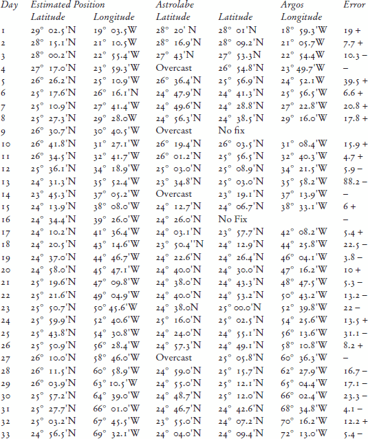
To assess the accuracy of the observed positions aboard the boat by astrolabe the intention was to radio through the boat's calculated position for noon each day and compare these with the position relayed by an Argos satellite transmitter which was fitted to the boat and gave its position every six hours.
The voyage started from the island of Gomera, Columbus's departure point, on 23 September.Footnote4 Seasonally, this was within eight days of Columbus's start. The last opportunity to check the astrolabe against a reasonably accurate dead reckoning came the next day and gave the astrolabe reading as 17.5 miles north of the estimated position (EP). In fact, unknown at the time, the EP was 3 miles north of the position logged by the Argos transmitter. The errors of the astrolabe for the next two days were 8 miles north and then 10 miles south. On the fourth day no reading was possible owing to complete cloud cover.
Already some lessons were being learned about the use of the astrolabe. Trying to take the altitude of the Pole Star was almost impossible for one person to achieve. It definitely requires one person to hold the instrument and another to take the sight. If there was any cloud that created haziness in the sky, readings of the sun's altitude were very difficult because the small spot of sunlight coming through the upper pinnule in the alidade was very hard to see against a shiny brass surface. Putting black masking tape on the lower alidade plate improved matters, but it remained imperfect. It was the application of a candle flame to blacken the surface which proved very effective in the end. This was probably a trick well known to renaissance navigators, but had to be rediscovered 500 years later in a practical environment.
The comparison between the EPs, the astrolabe latitudes and the Argos satellite positions given for noon each day are tabulated opposite. The actual errors over 33 days are far smaller than was anticipated. The largest error, 88 miles on the thirteenth day, can be explained because the sun was in haze. But the average error in latitude, ignoring the reading on the thirteenth day, which any navigator would have mistrusted, recognizing that it might not be a very accurate reading at the time, is 13.63 nautical miles.Footnote5
Assuming that the error in this experiment using the astrolabe might be 15 nautical miles on each observation, the lookout on the masthead of a late fifteenth-century vessel, whose range of visibility to the horizon from a height of 70 feet was just under 10 miles, could expect to sight a familiar hill 200 feet high at a distance of 26 miles. Higher objects would be seen even earlier. Navigators, then as now, always noted obvious features ashore such as prominent hills or mountains to guide them to their destinations. It was a part of their craft. Thus an error of 15 miles when making a landfall would have been perfectly acceptable to an experienced pilot at that time, and would have enabled them to steer themselves to their chosen destination.Footnote6
The mariner's astrolabe, in the hands of a navigator familiar with it, would have provided a reasonably accurate means of calculating latitude at sea, and for calculating the latitude of ports. It remained in use until towards the end of the seventeenth century when Davis's backstaff provided a more convenient and accurate means of measuring altitudes.
http://dx.doi.org/10.1080/00253359.2013.766999
© The Society for Nautical Research
Notes
1 Alan Stimson's estimate was to prove remarkably prescient.
2 According to May, the first reference to the Dutchman's log is in 1623, after the ship log, see May, A History of Marine Navigation. See also Waters, A History of Navigation, and Scott, ‘Speed, Navigational Accuracy and the Ship Log’. According to Eva Taylor, however, both the ‘Dutchman's log’ and the ‘common log’ are generally regarded as having come into use after 1500. See Taylor The Haven-finding Art, 201.
3 The astrolabe was reproduced by kind permission of Alan Stimson.
4 Knox-Johnston, The Columbus Venture.
5 The significance of the differences in longitude are not pertinent to the study of the accuracy of an astrolabe, but might be explained by an underestimate of the strength of the equatorial current.
6 Although the estimate of longitude was nearly 200 miles short, on this occasion a reflected wave indicated the proximity of land to leeward at a range of 22 miles. Polynesian navigators are thought to have been able to discern islands by this means at distances of up to 100 miles.
Related Research Data
References
- Knox-Johnston , R. 1991 . The Columbus Venture London
- May , W. E. 1973 . A History of Marine Navigation Henley on Thames
- Taylor , E. G. R. 1956 . The Haven-finding Art London
- Scott , F. 2006 . Speed, Navigational Accuracy and the Ship Log . Mariner's Mirror , 92 ( 4 ) : 477 – 81 .
- Waters , D. W. 1953 . A History of Navigation in Elizabethan and Stuart Times London