Abstract
Suspended sediment yields (SY) were measured at seven sites in the Motueka catchment to characterise major influences on sediment yield variation and estimate sediment delivery to Tasman Bay. Relationships between storm event SY and peak flow were used with long-term flow records to calculate SY. At large catchment scale, there were clear differences in SY related to geology and rainfall, but the major influence on SY was the impact of a >50-year return period storm that caused an increase in event SY ranging from 10–20 times in the headwaters to 2–3 times at the coast. Forest harvesting was an important influence at small catchment scale, producing a five-fold increase in event SY. The magnitude of the SY increase, the time to recover and the total area affected were all smaller than the impact of large storms. Annual SY at the coast was extremely variable, ranging from 49,000 t to 1.7 Mt.
Introduction
Integrated catchment management (ICM) recognises that the resources and components of the environment within a catchment are inextricably linked. Sediment is a common focus in many ICM studies since variations in the flux of sediment can cause both on-site and off-site problems within catchments, and the transport of other contaminants (e.g. phosphorus, faecal microbes) is often associated with sediment transport. At the inception of the Motueka ICM programme, Dunne and Likens (Citation2000) identified the need to define the sources and dispersal of sediment as a key goal of the programme. The sediment issues they identified included: the filling of channel pools with medium-sized sand affecting trout habitat, the implications of changes in bed elevation and gravel-bar volume for gravel extraction from the channel, sedimentation effects on the scallop fishery in Tasman Bay, and changes in the supply of sediment to the Bay causing long-term changes in the texture of the substrate and the form of the Bay itself as a result of erosion and deposition.
Fine sediment in streams and coastal receiving waters is a major pollutant that can have severe impacts on the ecology and habitat of freshwater and marine ecosystems. Both suspended and deposited sediment cause effects ranging from degradation of habitat for fish and invertebrates through to reduction in recreational opportunities in receiving waters. Recent reviews have established fine sediment as one of the main stressors on freshwater and marine environments in New Zealand (Davies-Colley et al. Citation2003; Morrison et al. Citation2009). Fundamental to understanding and managing these impacts is establishing the variation in sediment loadings and the major factors controlling this variation. Natural factors, particularly climate and geology, and anthropogenic changes, such as deforestation, can both impact on rates of sediment generation.
In north-west Nelson, New Zealand, sediment yield data, and information on the major factors influencing yields have been limited. While the area is generally regarded as having low sediment yields because of the underlying geology (Griffiths & Glasby Citation1985; Hicks & Shankar Citation2003), there have been concerns about accelerated sediment delivery during forest harvesting on some rock types (e.g. Mosley Citation1980). The impact of sediment on freshwater values, including the world-renowned trout fishery in the Motueka River (Graynoth Citation1979; Jellyman et al. Citation2003) and the developing aquaculture industry in Tasman and Golden bays (Forrest et al. Citation2007), have also raised questions about the potential effect of land use on sediment generation. These questions are being addressed as part of the Motueka ICM research programme (Basher Citation2003), which has implemented targeted data collection within the Motueka catchment () to provide improved estimates of sediment yield and sediment delivery to Tasman Bay, and to characterise the major influences on sediment yield variation.
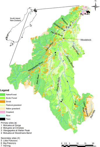
Figure 1 Map of Motueka catchment showing land cover and location of sediment sampling sites.
At regional and national scale in New Zealand, geology and rainfall are the major drivers for variation in sediment yield (Hicks et al. Citation1996). At this scale, factors such as topography, land use and vegetation cover appear to have less influence on sediment generation rates than they do at the hillslope scale (e.g. Page et al. Citation2000; Fahey et al. Citation2003; Glade Citation2003). In north-west Nelson, because the geology is highly diverse (ranging from clay-bound Moutere Gravel to highly indurated igneous and sedimentary basement rocks) and rainfall varies by a factor of 4–5, it is expected that sediment yields will be highly variable and that any land-use influence will be superimposed on this variation. Hicks & Shankar (Citation2003), using the Suspended Sediment Yield Estimator (SSYE), estimate specific suspended sediment yields (SSY) of 80–170 t/km2/year for the four major rivers of north-west Nelson (Aorere, Takaka, Motueka and Waimea). Within these catchments yields are estimated to vary from <50 to>1000 t/km2/year.
Existing sediment yield data for the Motueka catchment are sparse, being limited to first-order estimates of average annual sediment yield at large catchment scale and small-catchment data on the influence of land use. Griffiths & Glasby (Citation1985) calculated the suspended sediment yield (SY) of the Motueka River to the coast at 277 t/km2/year. However, this estimate was based on a relationship between SY and rainfall derived from dominantly greywacke and schist catchments throughout the South Island (Griffiths Citation1981), and probably overestimated the yield. Mosley (Citation1980), using the Griffiths (Citation1981) method, suggested much of the yield is derived from the high-rainfall, steep terrain of the west-bank tributaries and estimated rates of 119 t/km2/year from the Dart River and 583 t/km2/year from the Wangapeka River. Hicks & Shankar (Citation2003) provide revised estimates of sediment yield () based on compilation of the limited available suspended sediment (SS) data (from four sites over a limited range of flow) as well as improved understanding of the influence of rock type and rainfall (Hicks et al. Citation1996). This analysis suggests a relatively low yield from the western tributaries underlain by strongly indurated metasedimentary and igneous basement rocks (Wangapeka River—74 t/km2/year, Baton—66 t/km2/year) and much higher yields from the hilly Moutere Gravel terrain (Motupiko—290 t/km2/year, Stanley Brook—167 t/km2/year) and the southern headwaters underlain by strongly indurated metasedimentary and ultramafic basement rocks (Upper Motueka—362 t/km2/year). It also suggests a significantly lower whole catchment yield (168 t/km2/year) than earlier estimates. These data suggest the biggest contributors to sediment yield at the coast are the Motupiko River and Upper Motueka, which provide a far greater percentage of the load than their percentage of the catchment area (). The Wangapeka River also provides a significant contribution, although the amount (10%) is far less than its percentage of the catchment area (23%).
Table 1 Annual specific suspended sediment yields for major subcatchments of Motueka River, predicted from rainfall and geology.
Since at least the late 1970s there has been concern about the impacts of land use on sediment generation, particularly forest harvesting on highly erodible Separation Point granite. Mosley (Citation1980) made a semi-quantitative estimate of the impact of forest road erosion in the Dart Valley and estimated that annual sediment yield from the area of the valley that was roaded increased to 710 t/km2/year, compared with a background rate of 119 t/km2/year. However, he suggested much of the sediment associated with roading was stored on slopes and in headwater channels and not delivered downstream. Using a plot-based approach Fahey & Coker (Citation1989) estimated sediment production rates from surface erosion on existing roads in forests on Separation Point granite at 37 t/km2/year. At the time of peak harvesting, this was predicted to rise to 160–320 t/km2/year. Mass movements during infrequent high-magnitude storms were the major contributors to erosion (Coker & Fahey Citation1993). Because the roaded areas cover a small proportion of the forest, Fahey & Coker (Citation1989) suggested it is unlikely that they make a major contribution to the sediment yield of large rivers in the area.
Land use and forest harvesting effects on sediment yield have also been examined in catchments underlain by Moutere Gravel. In small catchments at Big Bush Forest (0.05–0.20 ha), under a rainfall of 1700 mm/year, sediment yield was 5–35 t/km2/year under undisturbed native forest (O'Loughlin et al. Citation1978; O'Loughlin Citation1980). Over a 2-year period, most sediment was derived from streambank erosion during a single storm of <1-year recurrence interval. After harvesting of trees at Big Bush, sediment yields increased (in the short term) up to >100 times, depending on the harvesting method, with most sediment delivered in a few high-intensity storms with roads becoming an important sediment source (O'Loughlin et al. Citation1980; Fahey & Jackson Citation1993; Fahey et al. Citation1993). Short-term (1983–86) data from two small Moutere experimental station catchments (0.04 and 0.07 ha), under an annual rainfall of 1050 mm, were 4 t/km2/year under pine forest and 79 t/km2/year under pasture (Hicks Citation1990). The storm events that were most effective in transporting sediment occurred every few months. Similarly, Smith (Citation1992) measured sediment yields of 21 t/km2/year under pasture, and 32 and 67 t/km2/year from two catchments under pasture with riparian pine. She suggested increased erosion in the pasture catchments with riparian pine was associated with poor ground cover in riparian forest causing overland flow and streambank erosion. It is interesting to note that the sediment yields measured from small Moutere Gravel catchments are considerably lower than those estimated at larger catchment scale ().
This paper describes recent work to improve knowledge of SY in the Nelson region, based on a case study of the Motueka River. Because the variation in SY within the Motueka River was poorly constrained by measurements, data collection focused initially on getting a high-quality record to characterise both sediment yield from major tributaries and sediment yield to the coast. Four sites with existing flow recorders that encompassed the major variations in geology and rainfall within the catchment were instrumented for SS measurement. These were all large catchments, predominantly with mixed land use. The impact of the March 2005 storm on sediment yield at these sites is described in Hicks & Basher (Citation2008). Subsequently, three further sites in small catchments undergoing land use change were instrumented. The objectives of the study were to (1) measure rates of sediment generation from major subcatchments and total sediment delivery to Tasman Bay, (2) measure the sediment yield response to forest harvesting, and (3) determine the major influences on sediment yield variation.
This research addresses two of the themes of the ICM programme: ‘Managing land uses in harmony with freshwater resources’ and ‘Managing land and freshwater resources to protect and manage marine resources’. It has provided data to underpin development of understanding of sediment loading to the coast (Forrest et al. Citation2007; Gillespie et al. 2011, this volume) and the impacts of storm events on microbial contaminant delivery (McKergow & Davies-Colley Citation2010).
Methods
Study area
The Motueka River drains a 2075-km2 catchment into Tasman Bay at the northern end of the South Island (). Elevation ranges from sea level to almost 1900 m. The western tributaries (notably the Wangapeka and Baton) and southern headwaters are mountainous, receive relatively high rainfall (up to 3500 mm/year) and are a dominant influence on the flow regime of the lower river (Basher Citation2003). The eastern tributaries and the major southern tributary (Motupiko River) are hilly and receive much lower rainfall. Upper reaches of both areas are characteristically steep, with boulder or cobble-bed streams and limited sediment storage. The middle and lower reaches are gravel bed rivers, typically entrenched in relatively narrow floodplains and terraces. The latter comprise about 12% of the catchment.
The catchment is geologically diverse (Rattenbury et al. Citation1998). The western tributaries drain Palaeozoic metasediments (Mt Arthur Group) and basic igneous rocks (Riwaka Complex), with smaller areas of Mesozoic weathered granites (Separation Point granite) and Tertiary soft sediments. The southern headwaters drain Palaeozoic metasediments (Maitai Group) and ultramafic rocks (Dun Mountain Group). The hilly eastern tributaries and the Motupiko River drain mainly Late-Tertiary–Quaternary gravels (Moutere Gravels). Geology strongly influences water yield (Johnston Citation1980) and the SY estimates of Hicks & Shankar (Citation2003).
Annual rainfall averages 1670 mm across the catchment, but there is a strong spatial pattern of variation related to topography and distance from the coast: rainfall is highest in the headwaters of the western tributaries and southern headwaters (up to 3500 and 2000 mm/year respectively). Lowest annual rainfall is in the hilly central part of the catchment (<1000 mm/year). In the lower, drier areas of the catchment rainfall has a marked winter seasonal maximum, whereas in the higher rainfall areas variation is more storm-driven. Variation in annual rainfall is very high (at Motueka it has ranged from 687 to 1747 mm and in the headwaters from 3043 to 5116 mm). Storms can arrive from the north, west or south, and the rainfall distribution over the catchment is typically patchy during events. Short- to medium-duration rainfall is often high intensity and can cause severe flooding and erosion.
Over the Easter weekend of 2005 (23–26 March) heavy rain fell in the upper Motueka and Motupiko tributaries (170 mm over 12 h with hourly intensities up to ∼60 mm/h), with lower falls elsewhere in the catchment. A rainstorm of this magnitude has a >50-year return period over durations from 0.5 to 24 h. The storm caused multiple landslides and reactivated gully complexes, in both the mountainous areas in the Motueka upstream of Motueka Gorge and the hilly terrain drained by the Motupiko River. These erosion sites are only infrequently active when a rainfall threshold is exceeded. This event was a significant influence on sediment yield in the upper Motueka and Motupiko during the period of data collection, but had less influence at the coast and little influence in the Wangapeka (Hicks & Basher Citation2008).
The western and southern headwaters have a predominantly native forest cover, with some scrub and grassland. The hillslopes of the lower reaches of these and the eastern tributaries are typically commercial exotic forest or pastoral farmland used for sheep and cattle grazing, while the valley floors are used for grazing, dairying or horticulture. The exotic forest is concentrated on Moutere Gravels and Separation Point granite rock types.
Suspended sediment monitoring
Suspended sediment (SS) was measured at seven sites in the Motueka catchment (, ). The sampling network comprises four primary large-catchment sites that have a long-term flow record and characterise the major variation in rainfall and geology within the catchment and sediment load to the coast: (1) the Motueka River at Motueka Gorge represents the mountainous, high-rainfall, southern headwaters underlain by metasediments (Maitai Group) and igneous rocks (Dun Mountain ultramafics); (2) the Wangapeka River at Walter Peak represents the mountainous, high-rainfall, terrain of the western tributaries underlain by metasediments (Mt Arthur Group) and igneous rocks (Riwaka Complex basic igneous rocks and Separation Point granite); (3) the Motupiko River at Christies Bridge represents the low-rainfall, hilly, Moutere Gravel terrain; (4). the Motueka River at Woodmans Bend gives the cumulative discharge of sediment to the coast from the mainstem river.
Table 2 Catchment characteristics for suspended sediment monitoring sites.
Each of these sites has mixed vegetation cover (), and while some forest harvesting was taking place during the monitoring period there was no major change in the total area of forest harvesting. At these four sites, continuous SS monitoring was undertaken for 4–6 years (beginning in November 2002 at three of the sites and April 2004 at the fourth).
In addition, three secondary sites sample small catchments with more uniform geology and land use. Each had native forest in the steep headwaters and predominantly plantation forest, with some pastoral farming, in the middle and lower reaches. Geology varies within these catchments, with metasediments and basic igneous rocks in the steep headwaters and erodible Separation Point granite in the middle and lower reaches where forestry is concentrated. Significant forest harvesting occurred in these catchments during the monitoring period. Continuous SS monitoring was undertaken for 2 years at these sites (July 2006–June 2008). In addition, there was an earlier period of less intensive SS monitoring (1997–2001) when only flow and storm SS concentrations (SSC) were measured (summarised in Hewitt Citation2002). The focus in this paper is on the period of continuous data collection and the comparison between the Herring Stream (with substantial forest harvesting) and the Little Pokororo and Big Pokororo Streams (with limited forest harvesting). However, these results can also be compared with the earlier period of data collection when there was no harvesting in the Herring Stream and active harvesting within the other two catchments.
The measurement strategy at all sites had two main components: (1) to continuously record back-scatter-type turbidity as a surrogate for SSC, and (2) to collect water samples during floods using automatic samplers to compile calibration relationships between turbidity and SSC beside the sensors. These data were then used to compile a continuous record of SSC. The analytical procedures are described in detail in Wild et al. (Citation2006).
At all seven sites, the instrumentation included a data-logger, turbidity sensor, stage sensor and an automatic sampler. SSC was proxied continuously (every 15 min) with nephelometric turbidity sensors (Greenspan TS300 or TS1200). They were equipped with a small water pump that regularly squirted a jet of water over the lens to inhibit bio-fouling. At the four primary sites, the stage sensor record was used by the data-logger to provide a running total of water discharge and the auto-samplers were activated on a flow-proportional basis once a threshold stage was passed. At the secondary sites, the auto-samplers were activated on a fixed time (15-min) basis once a flow threshold was exceeded. Samples were analysed in the laboratory for SSC and turbidity. Rigorous quality assurance procedures were implemented to ensure reliable data from the turbidity sensors and reliable estimates of SSC (described in Wild et al. Citation2006).
Suspended sediment yield calculation
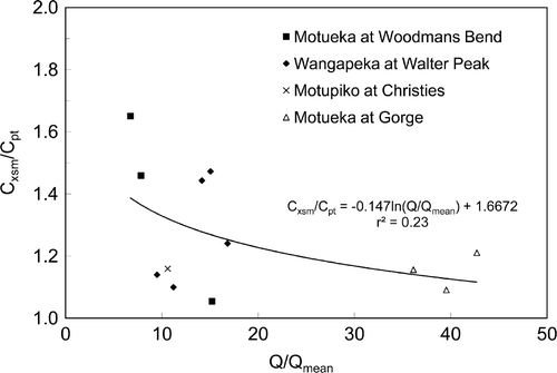
The auto-sampler data from high-flow events was used to maintain a running field-based relationship between turbidity and SSC, to check for drift in turbidity–SSC relationships, to compile running water discharge (Q)–SSC rating relationships, and to provide a backup SSC record in case of turbidity sensor failure. Gaps in the turbidity-generated record (related, for example, to sensors washing away during floods) were filled by preference with SSC data interpolated from the auto-samples, or otherwise using the current SSC–Q rating. Occasional manual depth-integrated sampling at the primary sites was used to relate the point SSC at the sensor and auto-sampler intake (C pt) to flow-weighted cross-section mean SSC (C xsm). The ratio of C xsm to C pt ranged from 1.05 to 1.65 () and a correction was applied as a function of the ratio of measured flow (Q) to mean flow (Q mean). No cross-section mean SSC data were available for the secondary sites on small streams and it is assumed they are better mixed and no correction is applied.
Figure 2 Relationship between cross-section mean suspended sediment concentration (SSC) (C xsm), point SSC (C pt) and flow, expressed as the ratio of measured discharge (Q) to mean discharge (Q mean).
Mean SY over the monitoring period and SYs during discrete events were integrated from the SSC and Q series records. Events were defined from the onset and ending of quickflow, which is separated from the hydrograph using the approach of Hewlett & Hibbert (Citation1967). These data were used to determine relationships between event SY and peak flow (Q p) and then these relationships were used to estimate yields in unmeasured events over the complete flow record. Because the sites drain very different sized catchments, comparisons are based on normalising the data for area as specific SY (SSY, t/km2/yr). Uncertainty associated with the sediment yield estimates varies according to the period of record examined, but for the long-term estimates of SSY ranged from ±10% for Motueka at Woodmans Bend to ±29% for Motupiko at Christies. These long-term yield uncertainty estimates were derived by summing the variance due to of the error-of-estimate associated with the event SY vs Q p relationships, assuming that errors were uncorrelated between events.
Results
Suspended sediment record
The SS record samples a large number of storms and covers a wide range of flow conditions. Between 62 and 126 events were analysed at the primary sites and 27 or 28 events at the secondary sites. Fewer events occurred at the Motupiko and Woodmans Bend sites than at Motueka Gorge and the Motupiko. The record includes flows up to c. 30–40 times mean flow at most sites and >100 times mean flow at the Motupiko and Motueka Gorge sites (). Maximum measured SSC ranged from 1870 mg/l at the Little Pokororo to 6142 mg/l at the Herring. The SSC–Q relationships show a large amount of scatter at all sites (), with the widest scatter at the Gorge and Motupiko sites and sediment yields calculated using a rating curve approach would have high uncertainty because of this scatter. Concentrations vary by up to two orders of magnitude for a given flow. At three of the four primary sites, this scatter increased significantly after the March 2005 flood, the exception being the Wangapeka, and suggests non-stationarity in SSC–Q relationships (Hicks & Basher Citation2008). At two of the secondary small-catchment sites (Little Pokororo and Herring) hysteresis effects relating to varying sediment supply during run-off events account for much of the scatter. Concentrations tended to be higher on the rising stage than the falling stage of flow events.
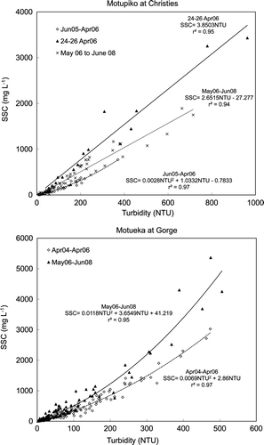
Figure 3 Relationships between suspended sediment concentration (SSC) and flow.
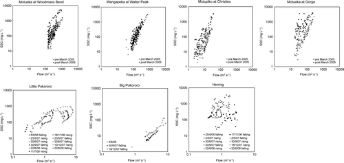
Table 3 Summary of measured data for suspended sediment monitoring sites.
There was a strong correlation between turbidity and SSC at all sites () with r 2>0.9 for most sites. However the correlations varied between sites (); some were linear and some were curvilinear (Motueka Gorge, Wangapeka, Little and Big Pokororo). The different relationships among the sites are probably a result of variations in SS particle size. Specific turbidity (NTU; mg/l) tends to be lower for coarser particles. The steepest relationships (low specific turbidity) occur at Wangapeka and Motueka Gorge, where the suspended load is expected to be coarser because of the source rocks (granite in the Wangapeka) or proximity to source terrain (Motueka Gorge). Alternatively, the differences may reflect intrinsic differences between the sensors, perhaps relating to drift in their internal calibration (all were bench-calibrated against formazin standards before field deployment). Regular collection of calibration samples allowed these effects to be accounted for in the calculation of SSC and for reliable estimates of SSC to be made from turbidity. They also altered through time () or at higher turbidity at some of the sites, emphasising the importance of maintaining strict quality assurance procedures to obtain reliable SSC data from the turbidity sensors. Multiple turbidity–SSC relationships were used at all the primary sites. For the four primary sites, Motueka Gorge and Wangapeka tended to have similar relationships between SSC and turbidity, while Woodmans Bend had far lower SSC for an equivalent turbidity reading. The Motupiko was intermediate between the two. At the secondary sites, there were similar relationships between SSC and turbidity at all three sites.
Figure 4 Relationship between auto-sampled suspended sediment concentration (SSC) and turbidity (inset in the bottom diagram shows the similarity between the Big Pokororo and Little Pokororo).
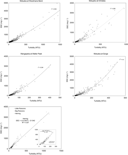
Figure 5 Relationship between auto-sampled suspended sediment concentration (SSC) and turbidity at different times at Motupiko at Christies and Motueka at Gorge sites.
Storm event SY was closely related to peak flow (when plotted on a log–log scale) as has been found in previous New Zealand studies (e.g. Hicks Citation1990, Citation1994; Basher et al. Citation1997; Hicks et al. 2000; Fahey et al. Citation2003). The scatter in these rating relationships is far lower than for the SSC–Q rating relationships. The event–yield ratings all had a power law relationship of the form:
Figure 6 Relationships between event specific sediment yield and peak flow at primary and secondary sites. Best-fit regression lines are shown.
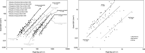
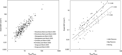
Figure 7 Relationships between event specific sediment yield and ratio of peak flow to mean flow at primary and secondary sites. Best-fit regression lines are shown for secondary sites.
Sediment yield at primary sites
Variation in annual SSY was very high (), particularly at the Motueka Gorge (106–2535 t/km2) and Motupiko sites (21–539 t/km2), but even at the other two sites it varied by more than a factor of five. This variability reflected the number and size of events occurring each year and particularly the influence of the March 2005 flood event, and is indicative of the difficulty of measuring long-term average annual sediment loads from short-term data collection programmes (Hicks & Basher Citation2008). Over the common period of measurement for all four sites (May 2004–June 2008), SSY ranged from 71 t/km2/year at the coast (Woodmans Bend) to 745 t/km2/year at Motueka Gorge. However, the results for the Motueka Gorge and Motupiko sites were heavily influenced by a single low-frequency event with a 50-year recurrence interval that caused elevated SSY during the monitoring period. The Wangapeka showed no influence of that event and at Woodmans Bend it was little more than the mean annual flood. In the 2004/05 year, SSY peaked at 2535 t/km2/year at Motueka Gorge and 539 t/km2/year at the Motupiko site. While the March 2005 event produced the highest event sediment load at Woodmans Bend in the 5 years of record (60 t/km2), there were few other events in the 2004/05 year, and the annual yield was only the second highest (after 2003/04) in the 5 years of record.
After the March 2005 event, the shift in event SSY–Q p relationships was greatest at the Motueka Gorge site, and also quite large at the Motupiko (). At these sites, the slope of the regression line remained similar, but similar peak flows produced higher SSY. At Woodmans Bend, the slope of the regression line steepened, suggesting lower yields during small events and higher yields during large events, resulting in an overall increase in event SSY. At the Wangapeka there was little change in event SSY relationships.
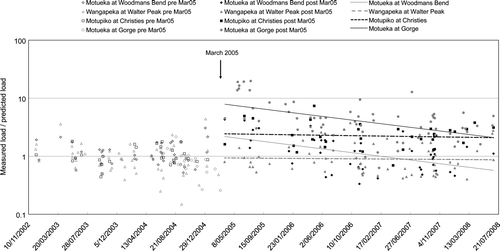
The extent of the increase in yield can be examined using the pre-March 2005 SSY–Q p relationships to predict event SSY, and comparing the predicted yields with observed yields. plots the ratio of measured to predicted yield for the SS record and shows the best-fit regression lines indicating the trend since March 2005. This suggests that at Motueka Gorge yields increased by a factor of 10–20 and they have been slowly declining back towards pre-March 2005 event yields. At Motupiko, yields increased by 4–5 times and have remained high with little trend through time. Even though the effect of the event was highly diluted below the Wangapeka confluence, event yields increased 2–3 times at Woodmans Bend and the trend line suggests on average event yields are now lower than they were before March 2005. However, the regression coefficients for the trend lines are quite low (<0.3) and it appears that the scatter in the ratio of measured to predicted yields has increased since March 2005. There was no change in yields at the Wangapeka, with the ratio of predicted to measured yields close to one ().
Figure 8 Trend in ratio of predicted specific suspended sediment yield (SSY) to measured SSY at primary sites. Best-fit regression lines for the temporal trend in predicted SSY are shown for the post-March 2005 data.
At all sites, the sediment load was dominated by large events. The March 2005 event was by far the largest event at three of the four sites, carrying >70% of the load measured over the whole monitoring period at Motueka Gorge and Motupiko and 20% at Woodmans Bend. Although the yield at the Wangapeka was lower, it was still dominated by large events, with the largest event measured at that site carrying 26% of the total load over the monitoring period. The largest event produced a yield of 127 t/km2 from a flood with about a 10-year recurrence interval. With the exception of the March 2005 flood, this is the highest event SSY at any of the sites. The five largest events carried between 58 and 89% of the total load measured over the whole monitoring period across the four sites.
Sediment yield at secondary sites
Over the 2-year monitoring period, SSY ranged from 11 t/km2/year at Big Pokororo to 152 t/km2/year at Herring (). The Little Pokororo and Big Pokororo had similar yields (11 and 18 t/km2/year) and were far lower than the Herring, primarily in response to the higher level of forest harvesting in the Herring than the other sites. While there was a low level of forest harvesting in the Big Pokororo, it tended to have a lower yield than the Little Pokororo. At the storm-event level, the Herring generally produced 4–10 times more sediment (expressed as SSY) than the Little Pokororo and 10–15 times more than the Big Pokororo (). The differences between the Little Pokororo and Big Pokororo are likely to reflect an inherent difference between the two catchments. On average, almost twice as much sediment (per unit area) was generated from the Little Pokororo, possibly as a result of the greater proportion of the catchment on Separation Point granite.
Annual yields were lower in 2006/07 than 2007/08 at all sites as a result of the smaller number of storm events (12 in 2006/07 and 18 in 2007/08) and lower total rainfall. Additionally, at the Herring, forest management moved from harvesting to replanting and this would have reduced sediment generation. The annual yields were dominated by a few large events, particularly at the Herring (). The four largest events accounted for >75% of the total yield over 2 years at the Herring and Big Pokororo and 60% at the Little Pokororo.
Figure 9 Comparison of storm event yields and rainfall at the three secondary sites.
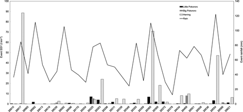
While there was a tendency for the largest rainfall events to produce high SSY, there are some longer duration events where rainfall was high but sediment yield was low (e.g. 10 January 2007, 30 June 2007). There was a close relationship between increasing event SSY and increasing peak flow (with log transformation), with r 2 ranging from 0.65 at Little Pokororo to 0.89 at Herring (). When normalised for flow (), the Herring produced almost an order of magnitude more SS than the other two catchments. The regression line for the relationship between Q p/Q mean and event SSY had a similar slope for both the Little Pokororo and Big Pokororo, but the Herring had a steeper slope indicating larger magnitude floods have a relatively greater effect on sediment generation at the Herring than the other two sites.
Similar results were obtained during monitoring of these sites from 1997 to 2001, reported in Hewitt (Citation2002). At this time, there was no harvesting in the Herring, while the Little Pokororo and Big Pokororo had both roading and harvesting activities underway. Sediment yields were estimated using a rating curve approach with higher uncertainty on estimated yields. However, the comparisons between the catchments again provide an estimate of relative yields (). During this period, annual SSY from the Herring, with no forest harvesting, ranged from 18–44 t/km2/year and averaged 30 t/km2/year. This compares with an average of 152 t/km2/year from 2006 to 2008, when the catchment was being harvested. By contrast, SSY from the Little Pokororo and Big Pokororo was much higher in 1997–2001, when the catchments were being harvested, than in 2006–08. Annual variability in SSY was high, ranging from 21–111 t/km2/year (average 57 t/km2/year) in the Big Pokororo and 44–151 t/km2/year in the Little Pokororo (average 90 t/km2/year). This variability appears to relate in part to variability in rainfall and area of forest harvesting (). In this period, the Little Pokororo also tended to produce higher SSY than the Big Pokororo. In both periods of data collection, almost twice as much sediment on average was generated from the Little Pokororo as the Big Pokororo. SSY in the Little Pokororo and Big Pokororo returned to pre-harvest levels within 5 years (), although the gap in monitoring from 2001 to 2006 precludes an accurate estimate of how long this has taken. Results from elsewhere in the country suggest the recovery time could be as little as 2–3 years (Eyles & Fahey Citation2006).
Table 4 Summary of measured data for the secondary catchments for 1997–2001, and comparison with 2006–08 data.
The results from both periods of data collection show a consistent trend for sediment yields to increase associated with forest harvesting. While factors such as variation in rainfall and flooding patterns, and variation in the area harvested, also affect the extent of this increase, the 2006–08 data suggest about a five-fold increase in the Herring SSY associated with forest harvesting and a five-fold decrease in the Little Pokororo and Big Pokororo associated with cessation of forest harvesting.
Discussion
Over the common monitoring period (2006–08), at all seven sites the Little Pokororo and Big Pokororo had very low SSY (), while the Herring, Wangapeka and Motueka Gorge had the highest yields. Forest harvesting activities were the cause of the very high yields at the Herring, while the high yield at Motueka Gorge was related to the residual effect of the March 2005 storm. The Wangapeka SSY for 2006–08 is relatively high compared with the entire monitoring period (2004–08), with the load in 2007/08 the highest in 5 years of monitoring because of one 10-year flood—over the 5 years of monitoring the Wangapeka had about half the yield of the Motupiko.
At the scale of the secondary catchments, the signature of land use change is very strong with about a five-fold increase in annual sediment load as a result of forest harvesting, but loads appear to return to pre-harvest levels within 2–3 years. This is comparable with sediment yield increases measured in other studies of forest harvesting impacts in New Zealand (O'Loughlin et al. 1980; Fahey et al. 2003; Phillips et al. Citation2005; Eyles & Fahey 2006). However, there were no major storms during both monitoring periods at the secondary sites and the increase in yield could have been considerably higher if harvesting had coincided with larger storms. Coker & Fahey (Citation1993) found that in a 20-year storm on similar terrain sediment generation dramatically increased because of mass movement along roads. However, the effect of harvesting on event yields appears to be of lesser magnitude than the effect of large storms.
At the primary sites, there are clear differences in SSY between the different tributaries over the monitoring period, with the highest yields coming from the upper Motueka and Motupiko. However, the major influence on measured yields is the impact of the March 2005 storm (Hicks & Basher Citation2008), which is superimposed on inherent differences related to geology and rainfall. This storm activated sediment sources that caused subsequent smaller, more common run-off events from these tributaries to carry sediment loads that were up to an order of magnitude larger than those events would have carried prior to March 2005. While this event did not significantly affect the western tributaries, the yields from the southern tributaries were sufficient to elevate sediment yields to the coast by a factor of 2–3 over the following 3 years. The increased yields (for events of the same peak flow) have declined exponentially with time at Motueka Gorge, but not at the Motupiko. After 3 years at both sites, yields remain above what they were prior to March 2005.
Hicks & Basher (Citation2008) suggest large storm events are ‘threshold’ events, which have been observed elsewhere, both in New Zealand and internationally (e.g. Hicks et al. Citation2000; Nistor & Church Citation2005). Hence it is likely that similar low-frequency events will affect other parts of the Motueka catchment at different times. This makes it difficult to compare yields across all seven sites when only some were affected by a low-frequency event during the monitoring period. However, the data collected in this study do allow the long-term sediment yield to be calculated () based on long-term flow records at the four primary sites and the event SSY–Q p relationships derived from this study. The flow record at Woodmans Bend is short (commencing 2002) but the long flow record at Woodstock (catchment area 1750 km2—see for location) can be used as a proxy for Woodmans Bend as flow at the two sites is very closely correlated. The following relationship was developed to convert flows at Woodstock (Q ws , m3/s) to flows at Woodmans Bend (Q wb , m3/s):
The mean yield is highly dependent on the length of record considered. If annual yields are averaged across the entire record at each site (), they range from 110 t/km2/year (at Motupiko at Christies) to 507 t/km2/year at Motueka at Gorge, while Wangapeka at Walter Peak (148 t/km2/year) and Motueka at Woodmans Bend (196 t/km2/year) are intermediate between these values. If they are averaged across the common period of record (1990–2008), the yield at Motueka at Gorge is little different from the longer record, but yields at Wangapeka at Walter Peak and Motueka at Woodmans Bend are both lower and of similar magnitude (136 and 137 t/km2/year). These results clearly illustrate the difficulty of determining long-term sediment yields from short-term data collection with extremely high inter-annual variability of sediment yield (). They also suggest low loads during the monitoring period at Motueka at Woodmans Bend and Wangapeka at Walter Peak, but higher loads at Motueka at Gorge and Motupiko at Christies. The data suggest some years produce extremely high loads, but the years producing the highest loads are highly variable across the four sites—1983 and 1974 at Motueka at Woodmans Bend; 1988, 1997, 1983 and 1998 at Wangapeka at Walter Peak; 2005 and 1998 at Motupiko at Christies; and 1995 and 2005 at Motueka at Gorge. These are years with large floods and/or high numbers of larger floods. While there is no flow record to calculate long-term yields at the secondary sites, it is likely that sediment yields during the 2-year monitoring period are also an underestimate of the long-term yields.
Figure 10 Variation in total annual suspended sediment load (t) at the four primary sites. Dotted grey line shows the average sediment load over the entire period of record at each site; solid grey line shows the average sediment load over the monitoring period (2002–08). Long-term data for Woodmans Bend are derived using the flow record for Motueka at Woodstock.
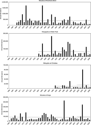
The results from Motueka at Woodmans Bend have implications for the developing aquaculture industry in Tasman Bay. Concern has been expressed at the decline of the scallop fishery in Tasman Bay in the last decade, which some commentators have attributed to the impacts of land-derived sediment. However, the data presented in this paper () suggest the load to Tasman Bay has been relatively low in the last decade (averaging 188,000 t/year) and aquaculture will have to manage the effects of periodic very high loads of sediment (up to 1.7 Mt/year).
This high inter-annual variability of SS loads and the observed non-stationarity of Q–SSC rating relations present significant issues for calculating sediment yields. As Brasington & Richards (Citation2000) note, not much high-quality data exist to examine the temporal variation in sediment transport over decadal and longer time scales, or over event-based time scales. However, it is increasingly recognised that SY response is typically highly episodic, with much of the load carried in events occurring over short time scales, and that event sediment flux is characterised by variable hysteresis and sediment exhaustion effects (e.g. Brasington & Richards Citation2000; Lenzi et al. Citation2003; Smith et al. Citation2003). Similar characteristics also control bedload transport (e.g. Marutani et al. Citation1999; Coulthard et al. Citation2007) and hillslope sediment delivery processes (Wolman & Gerson Citation1978).
Hicks & Basher (2008) outlined an approach to estimating long-term SSY taking account of threshold events where there is a long time-series of event peak flows available. It is based on monitoring sediment loads only long enough to identify the magnitude of hydrological event required to trigger a significant change in the SSC–Q or SSY–Q p relationship, measuring the relative increase in sediment load immediately after the threshold event, and defining the characteristic time for yields to return to the normal range. Applied to Motueka Gorge, and assuming a 1 in 20 annual recurrence interval for threshold events, the average annual sediment load is estimated at 507 t/km2/year compared with 94 t/km2/year if threshold events are not accounted for (Hicks & Basher Citation2008).
The data can also be used as a validation of the long-term yield estimates incorporated in the SSYE. The long-term yield at the coast from the SSYE (168 t/km2/year) compares well with that calculated for Motueka at Woodmans Bend (196 t/km2/year for the period 1969–2008). However, the SSYE appears to under-predict the yield for Wangapeka (74 compared with 148 t/km2/year for the period 1981–2008) and Motueka at Gorge (362 compared with 507 t/km2/year for the period 1965–2008), and over-predict the yield for the Motupiko at Christies (290 compared with 110 t/km2/year for the period 1990–2008). These results would also indicate that the Upper Motueka and Wangapeka rivers provide a greater contribution to the yield at the coast (20.4 and 17.2% respectively), and the Motupiko a smaller contribution (9.1%) than suggests.
Conclusions
Storm-event SYs were strongly correlated with peak flow across a wide range of catchment scales, and can be estimated using power law relationships. The small catchment sites produced higher event yields (in relation to peak flow) than the primary large-catchment sites. At the small-catchment scale, forest harvesting produced a five-fold increase in event yields, while in the large catchments a storm in March 2005 caused an increase in event yields ranging from 10–20 times in the headwaters to 2–3 times at the coast. Variation in annual SS load during the monitoring period was very high at the large-catchment sites, primarily related to the effect of large flood events. At all sites, annual yields were dominated by a few large events that carried most of the SS load.
At the large-catchment scale, there are clear differences in SY between the different tributaries, but the major influence on measured yields was the impact of the March 2005 storm, which is superimposed on inherent differences related to geology and rainfall. After 3 years, yields from headwater catchments affected by this storm remain above what they were prior to March 2005. Land use change is an important influence at small-catchment scale but the extent of the yield increase, the time to recover, and the total area affected are all smaller than the impact of large storms.
Sediment loads during the monitoring period were far lower than long-term yields at Motueka at Woodmans Bend (47%) and Wangapeka at Walter Peak (65%), but higher at Motueka at Gorge (119%) and Motupiko at Christies (146%). Long-term annual loads are extremely variable, ranging from 49,000 t to 1.7 Mt at the coast.
Acknowledgements
The study was funded by the Foundation for Research, Science and Technology under contract C09X0305 and by Tasman District Council. TDC also supplied flow data for some sites. Rob Merrilees and Kieran Scott from the NIWA Nelson field team did a great job in maintaining the instrumentation and collecting the suspended sediment data at the primary sites. Michelle Wild and Jo Bind processed much of the data. We thank Andrew Fenemor, Barry Fahey, Christine Bezar and two anonymous referees for reviewing earlier drafts of the manuscript.
Related Research Data
References
- Basher LR (compiler) 2003 . The Motueka and Riwaka catchments: a technical report summarising the present state of knowledge of the catchments, management issues and research needs for integrated catchment management . Lincoln, Landcare Research .
- Basher , LR , Hicks , DM , Ross , CW and Handyside , B . 1997 . Erosion and sediment transport from the market gardening lands at Pukekohe, Auckland, New Zealand . Journal of Hydrology (NZ) , 36 : 73 – 95 .
- Brasington , J and Richards , K. 2000 . Turbidity and suspended sediment dynamics in small catchments in the Nepal Middle Hills . Hydrological Processes , 14 : 2559 – 2574 .
- Coker , RJ and Fahey , BD . 1993 . Road-related mass movement in weathered granite, Golden Downs and Motueka Forests, New Zealand: A note . Journal of Hydrology (NZ) , 31 : 65 – 69 .
- Coulthard , TJ , Lewin , J and Macklin , MG . 2007 . 12 Non-stationarity of basin scale sediment delivery in response to climate change . Developments in Earth Surface Processes , 11 : 315 – 331 .
- Davies-Colley R , Cameron K , Francis G , Bidwell V , Ball A , Pang L 2003 . Effects of rural land use on water quality . Hamilton, National Institute of Water and Atmospheric Research. NIWA Client Report HAM2003-057 .
- Dunne T , Likens GE . 2000 : Research for integrated catchment management . Unpublished report for Landcare Research, Lincoln, New Zealand .
- Eyles G , Fahey B 2006 . The Pakuratahi Land Use Study: a 12 year paired catchment study of the environmental effects of Pinus radiate forestry . Napier, Hawke's Bay Regional Council. HBRC Plan No. 3868 .
- Fahey , BD and Coker , RJ . 1989 . Forest road erosion in the granite terrain of Southwest Nelson, New Zealand . Journal of Hydrology (NZ) , 28 : 123 – 141 .
- Fahey BD , Jackson R. 1993 . Hydrological impacts of converting old growth Nothofagus to P. radiata plantation, Big Bush, New Zealand . In: Water Issues in Forests Today, International Symposium on Forest Hydrology, 22–26 November 1993, Canberra . Pp. 23 – 24 .
- Fahey BD , Jackson RJ , Rowe LK 1993 . Long-term hydrological changes after beech conversion to pines, Big Bush, Southwest Nelson . In: Abstracts New Zealand Hydrological Society Symposium, Nelson, October 1993 .
- Fahey , B , Marden , M and Phillips , C . 2003 . Sediment yields from plantation forestry and pastoral farming, coastal Hawke's Bay, North Island, New Zealand . Journal of Hydrology (NZ) , 42 : 27 – 38 .
- Forrest , BM , Gillespie , PA , Cornelisen , C and Rogers , KM . 2007 . Multiple indicators reveal river plume influence on sediments and benthos in a New Zealand coastal embayment . New Zealand Journal of Marine and Freshwater Research , 41 : 13 – 24 .
- Gillespie PA , Forrest RW , Peake BM , Basher LR , Clement DM , Dunmore RA , Hicks DM . Spatial delineation of the depositional footprint of the Motueka River outwelling plume in Tasman Bay, New Zealand . New Zealand Journal of Marine and Freshwater Research, ICM special issue
- Glade , T . 2003 . Landslide occurrence as a response to land use change: a review of evidence from New Zealand . Catena , 51 : 297 – 314 .
- Graynoth , E . 1979 . Effects of logging on stream environments and faunas in Nelson . New Zealand Journal of Marine and Freshwater Research , 13 : 79 – 109 .
- Griffiths , GA . 1981 . Some suspended sediment yields from South Island catchments, New Zealand . Water Resources Bulletin , 17 : 662 – 671 .
- Griffiths , GA and Glasby , GP . 1985 . Input of river derived sediment to the New Zealand continental shelf. I Mass. Estuarine . Coastal and Shelf Science , 21 : 773 – 787 .
- Hewitt T 2002 . A study of the effects of forest management practices on sediment yields in granitic terrain in Motueka Forest . Unpublished Dip. Appl. Sci. dissertation. Palmerston North, Massey University .
- Hewlett JD , Hibbert AR 1967 . Factors affecting the response of small watersheds to precipitation in humid areas . In: Sopper WE , Lull HW . Forest hydrology, Proceedings of the International Symposium. New York, Pergamon . Pp. 275 – 290 .
- Hicks DM 1990 . Suspended sediment yield from pasture and exotic forest basins . In: Abstracts New Zealand Hydrological Society Symposium, Taupo, November 1990 . Pp. 20 – 23 .
- Hicks , DM . 1994 . Land-use effects on magnitude-frequency characteristics of storm sediment yields: some New Zealand examples. In: Variability in stream erosion and sediment transport, Proceedings of a Symposium held in Canberra, Australia, December 1994 . IAHS Publication , 224 : 395 – 402 .
- Hicks , DM and Basher , LR . 2008 . The signature of an extreme erosion event on suspended sediment loads: Motueka River catchment, South Island, New Zealand. In: Sediment Dynamics in Changing Environments, Proceedings of a Symposium held in Christchurch, New Zealand, December 2008 . IAHS Publication , 325 : 184 – 191 .
- Hicks DM , Shankar U 2003 . Sediment from New Zealand rivers. Wellington, National Institute of Water and Atmospheric Research . NIWA Chart, Miscellaneous Series No. 79 .
- Hicks , DM , Gomez , B and Trustrum , NA . 2000 . Erosion thresholds and suspended sediment yields, Waipaoa River basin, New Zealand . Water Resources Research , 36 : 1129 – 1142 .
- Hicks , DM , Hill , J and Shankar , U . 1996 . Variation in suspended sediment yields around New Zealand: the relative importance of rainfall and geology. In: Erosion and Sediment Yield: Global and Regional Perspectives, Proceedings of the Exeter Symposium, July 1996 . IAHS Publication , 236 : 149 – 156 .
- Jellyman DJ , Unwin MJ , James GD 2003 . Anglers’ perceptions of the status of New Zealand lowland rivers and their trout fisheries . Wellington, National Institute of Water and Atmospheric Research. NIWA Technical Report 122 .
- Johnston MR 1980 . Outline of geology of the Nelson district and some of the geological factors influencing water yield . In: Seminar on Land Use in Relation to Water Quality, Nelson, 7–8 November 1979. Nelson, Nelson Catchment and Regional Water Board . Pp. 113 – 121 .
- Lenzi , MA , Mao , L and Comiti , F . 2003 . Interannual variation of suspended sediment load and sediment yield in an alpine catchment . Hydrological Sciences Journal , 48 : 899 – 915 .
- Marutani , T , Kasai , M , Reid , LM and Trustrum , NA . 1999 . Influence of storm-related sediment storage on the sediment delivery ratios of tributary catchments in the Upper Waipaoa River, New Zealand . Earth Surface Processes and Landforms , 24 : 881 – 896 .
- McKergow , LA and Davies-Colley , RJ . 2010 . Stormflow dynamics and loads of Escherichia coli in a large mixed land use catchment . Hydrological Processes , 24 : 276 – 289 .
- Morrison MA , Lowe ML , Parsons DM , Usmar NR , McLeod IM 2009 . A review of land-based effects on coastal fisheries and supporting biodiversity in New Zealand. Wellington Ministry of Fisheries . New Zealand Aquatic and Biodiversity Report 37 .
- Mosley , MP . 1980 . The impact of forest road erosion in the Dart Valley, Nelson . New Zealand Journal of Forestry , 25 : 184 – 198 .
- Nistor , CJ and Church , M . 2005 . Suspended sediment transport regime in a debris-flow gully on Vancouver Island, British Columbia . Hydrological Processes , 19 : 861 – 885 .
- O'Loughlin CL 1980 . Water quality and sediment yield consequences of forest practices in north Westland and Nelson . In: Seminar on Land Use in Relation to Water Quality, Nelson, 7–8 November 1979. Nelson, Nelson Catchment and Regional Water Board . Pp. 152 – 171 .
- O'Loughlin , CL , Rowe , LK and Pearce , AJ . 1978 . Sediment yields from small forested catchments North Westland—Nelson, New Zealand . Journal of Hydrology (NZ) , 17 : 1 – 15 .
- O'Loughlin , CL , Rowe , LK and Pearce , AJ . 1980 . Sediment yield and water quality responses to clearfelling of evergreen mixed forests in western New Zealand. In: The Influence of Man on the Hydrological Regime with Special Reference to Representative and Experimental Basins, Proceedings of the Helsinki Symposium, June 1980 . IAHS Publication , 130 : 285 – 292 .
- Page , MJ , Trustrum , NA and Gomez , B . 2000 . Implications of a century of anthropogenic erosion for future land use in the Gisborne-East Coast region of New Zealand . New Zealand Geographer , 56 : 13 – 24 .
- Phillips , CJ , Marden , M and Rowan , D . 2005 . Sediment yield following plantation harvesting, Coromandel Peninsula, North Island, New Zealand . Journal of Hydrology (NZ) , 44 : 29 – 44 .
- Rattenbury MS , Cooper RA , Johnston MR 1998. Geology of the Nelson area . Wellington, Institute of Geological and Nuclear Sciences. 1:250,000 geological map 9 .
- Smith , BPG , Naden , PS , Leeks , GJL and Wass , PD . 2003 . The influence of storm events on fine sediment transport, erosion and deposition within a reach of the river Swale, Yorkshire, UK . The Science of the Total Environment , 314–316 : 451 – 474 .
- Smith , CM . 1992 . Riparian afforestation effects on water yield and water quality in pasture catchments . Journal of Environmental Quality , 21 : 237 – 245 .
- Wild M , Hicks DM , Merrilees R 2006 . Suspended sediment monitoring in the Motueka catchment: data report to 1 May 2006 . Christchurch, National Institute of Water and Atmospheric Research. NIWA Client Report CHC2006-087.
- Wolman , MG and Gerson , R . 1978 . Gerson. Relative scales of time and effectiveness of climate in watershed geomorphology . Earth Surface Processes , 3 : 189 – 208 .