Abstract
We examined catchment-scale transport of sodium monofluoroacetate (‘1080’) in rainfall run-off. We developed a hydrological model describing the overland transport of 1080 and validated model results using field data from a headwater catchment, where we intensively sampled a stream during a rainfall event (28 mm in 8 h) that followed 1080 aerial application. Only one stream sample contained a measurable concentration of 1080 (0.1 µg/l; collected 105 min from the start of rainfall), while 1080 was below detection limits (0.1 µg/l) in all other samples. Absence of visually observable overland flow conditions (puddles and saturated areas connected to the stream) early during the rainfall event suggested that overland transport might not have been the dominant mechanism in this catchment. Moreover, analyses of soilwater samples collected from lysimeters installed in the catchment indicated the propensity of 1080 to leach into soil, suggesting the need to investigate subsurface transport pathways.
Introduction
In New Zealand, sodium monofluoroacetate (‘1080’) is widely used to control the introduced Australian brushtail possum Trichosurus vulpecula, where it threatens natural ecosystems and where it carries bovine tuberculosis virus (TB). In steep, forested catchments infested with these pests, 1080-impregnated cereal baits are applied aerially. While these applications have greatly reduced the incidence of TB in livestock and improved the re-emergence of native flora and fauna, public concern over the possibility of 1080 contaminating drinking water persists. To address concerns relating to 1080 contamination of drinking water, an upper tolerable daily intake of 0.03 µg/kg/day for humans has been suggested (Foronda et al. Citation2007). Thus, an adult weighing 80 kg would exceed this if they drank 10 l of water a day with 1080 concentration 0.24 µg/l. This suggested standard is an order of magnitude lower than the current NZ Ministry of Health maximum acceptable value, 3.5 µg/l (Ministry of Health 2008). Additionally, local regional councils mandate measures such as buffer strips around streams in areas where aerial applications are conducted to prevent 1080 contamination (Suren Citation2006). Despite the use of buffers around large rivers, it is impractical, often impossible, to place buffers around small streams, so some degree of contamination is inevitable during aerial applications (Suren Citation2006). However, in the past, the vast number of water samples collected have shown that 1080 concentrations in surface waters following aerial applications are well below detection limits (0.1 µg/l) (e.g. Hamilton & Eason Citation1994; Eason et al. Citation1994; Fowles & Williams Citation1997; Booth et al. Citation2007; Eason & Temple Citation2008; Eason et al. 2010). Such observations indicate that 1080 contamination of streams might be insignificant. However, most monitoring for 1080 is done 24 h following an aerial application, and so may have missed transient contamination arising from baits that land directly in streams (Suren Citation2006).
The potential for contamination of drinking water, surface water and groundwater is controlled by the fate of 1080 in the catchment and its transport to receiving waters. Factors that influence this include the availability and abundance of unconsumed baits, persistence of 1080 in unconsumed baits, 1080 release rates from baits, degradation and decomposition of 1080 released from baits in soil and water, availability and mode of transport (overland flow and infiltration, resulting from rainfall), and catchment conditions controlling the 1080 transport pathways. Generally, a high incidence of possum kill, and re-emergence of native flora and fauna following aerial applications have been cited as evidence for large consumption of baits by target pests such as possums. Eason et al. (Citation1992) reported 85–95% possum kill following the aerial applications. Coleman & Morgan (Citation2002) observed that over years the sowing rates (baits applied per ha) have considerably decreased, from 10 kg to 2.5 kg, thereby reducing the availability of 1080 in the environment. These observations, high possum kill and substantial decrease in sowing rates infer that very little unconsumed 1080 baits might be available in the environment with potential to contaminate waterways.
Few studies have addressed degradation of 1080 baits under controlled (laboratory) conditions. King et al. (Citation1994) indicated that, in southwest Australian soils, under optimum soil moisture (8.3–15%) and ambient temperature (25–28 °C) conditions, indigenous micro-organisms can defluorinate as much as 50% of 1080 in 6 days and 87% in 23 days, and these degradation rates could be the lowest at 30% soil moisture levels. Bong et al. (Citation1979), based on laboratory studies, reported that 75% of 1080 is defluorinated at 25 °C in 14 days.
Bowen et al. (Citation1995) quantified 1080 release from cereal baits (Wanganui No. 7 and RS5) under simulated rainfall conditions (20 mm/h applied continuously for 10 h). They reported that as much as 50% of 1080 could be released from the baits in less than 3 h of rainfall. Similar results were reported by Suren (Citation2006), who studied the release of 1080 from cereal baits (Wanganui No. 7) submerged in running water, simulating 1080 release from baits directly falling into streams. He reported that as much as 50% of 1080 could leave baits after 5 h of submergence and 90% within 24 h. Parfitt et al. (Citation1994) predicted that under the frequent rainfall conditions characteristic of areas in NZ where aerial applications occur, any 1080 released from baits might leach into the soil. However, field observations by Bowman (Citation1999) and Eason et al. (Citation1992) found no evidence of 1080 leaching deep into the soil or to groundwater.
The fate of 1080 released from baits during rainfall events immediately following aerial applications, and the dominant transport pathways through which the released 1080 could be transported to surface waters, have not fully been investigated. Thus, there is little scientific information available on 1080 transport processes that could be used to allay concerns of potential 1080 contamination of surface waters. Information as to how, and whether, 1080 can move from land into streams is lacking, as are details as to whether we can develop measures to manage these transport pathways.
The goals of this study were thus to develop a better understanding of the fate of 1080 in unconsumed baits left in the field and of the catchment-scale transport of 1080 from land to streams during rainfall events immediately following aerial applications. The study reported here includes modelling and field components. The modelling component describes the development of a catchment-scale 1080 transport model. The field study was aimed at validating the model assumptions and results. During the field study, 1080 concentrations in stream and soilwater (at 100–150 mm depth) were monitored during a rainfall event immediately following an aerial application. Based on field and modelling studies, we drew inferences on the factors that could be controlling the fate of 1080 released from baits and the dominant 1080 transport pathways in catchments.
Methods and materials
Source-overland transport model
Our model included two parts: a sub-model to simulate 1080 release from baits during a rainfall event, thereby estimating the amount of 1080 available for transport (source sub-model) and a sub-model to simulate overland transport of released 1080 from land to stream (overland transport sub-model).
The source sub-model was based on 1080 release from bait data from Bowen et al. (Citation1995). Bowen et al. (Citation1995) studied 1080 release from Wanganui No. 7 and RS5 cereal baits with two different 1080 concentrations, 0.08 and 0.15% w/w 1080, under simulated rainfall conditions. They applied rainfall at an intensity of 20 mm/h for 600 min, and measured the amount of 1080 remaining in baits at 0.5, 1, 2.5, 5, 7.5 and 10 h since the start of rainfall. They concluded that 1080 release from baits varied with rainfall duration, with the majority of release occurring early, within the first 1–2.5 h of rainfall. In our field study, we used Wanganui No. 7 (0.15% w/w 1080) baits. Bowen et al. (Citation1995) indicated a sharp decline in 1080 release rates after 1 h of rainfall for Wanganui baits. Thus, two different best-fit equations were developed based on the data published by Bowen et al. (Citation1995) to represent the varying 1080 release rates with rainfall duration (EquationEquation 1).
where p is the amount of 1080 left in baits (mg of 1080 per g of bait) and t is the duration of rainfall (hours). In the absence of 1080 release data for other rainfall intensities, we used the above equations for all rainfall intensities.
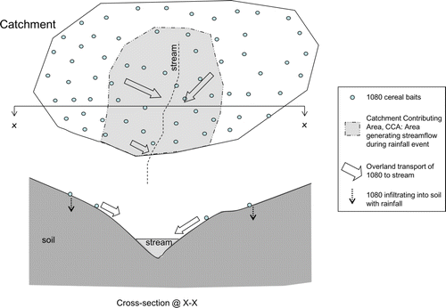
The overland transport sub-model described the extent of a catchment from which 1080 could theoretically be transported overland to streams, and in-stream 1080 concentrations during the rainfall event. This sub-model uses rainfall conditions (depth, intensity and duration) and catchment characteristics (slope, surface cover, soil drainage, stream density, stream length and stream roughness). Hydrological field studies in NZ (e.g. Srinivasan & McDowell Citation2009), and elsewhere (e.g. Freeze Citation1974), have shown that during rainfall events, a large proportion of stormflow might be generated from limited areas of a catchment, termed ‘catchment contributing areas’, or CCAs (). These CCAs are, usually, located adjacent to streams, hydraulically connected to water bodies, with potential to transport contaminants from the land (Gburek et al. Citation2002). Gburek et al. (Citation2002) assumed all rainfall on CCAs became stormflow, and accounted all stormflow generated to these CCAs. Thus, in order to account for stormflow generated, they varied the extent of CCAs according to rainfall received. The same assumption was adopted in our transport sub-model. During rainfall events, as rainfall varied, CCAs varied dynamically, spatially expanding and contracting over time, simulating stormflows. It was assumed that only the 1080 released within the CCAs was transported in overland flow to streams and 1080 released elsewhere in the catchment was added to the soil.
Figure 1 Schematic of catchment contributing area and 1080 overland flow transport model.
To construct the storm hydrograph, flow volume, time-to-peak flow and duration of stormflow were computed. The flow volume was estimated using the Curve Number method (Soil Conservation Service 1972), based on hydrologic soil group (well draining to poorly draining soils), land cover characteristics (good to poor), catchment antecedent conditions (wet to dry), catchment area and rainfall depth. Since 1080 aerial applications predominantly occur in forested catchments, only land under forest was considered. Poorly draining soils, poor land cover and wet antecedent conditions were assumed conducive for overland flow. Peak flow was estimated using the ‘rational method’ as a function of rainfall intensity, catchment area and a catchment run-off coefficient (Haan et al. Citation1994). The catchment run-off coefficient was determined as a function of the soil drainage class and the landscape slope (Haan et al. Citation1994). Time-to-peak flow was estimated using landscape (surface roughness and distance to stream) and stream characteristics (stream length and stream surface roughness) following a method described by Chow et al. (Citation1988: 165–167).
The 1080 release, stormflow and extent of CCA were computed at 15-min intervals. Also, at each time step, the width of the catchment adjoining the stream and contributing to run-off was estimated by dividing the CCA by stream length. Within the CCA, any 1080 released from baits was routed overland to the stream, and then to the catchment outlet. At each time step, based on the amount of 1080 transported and streamflow routed to the catchment outlet, the in-stream 1080 concentration was computed. Over the rainfall duration, the extent of the CCA, the amount of 1080 available for transport, the amount of 1080 routed to the catchment outlet and the volume of flow generated varied dynamically. Correspondingly, the modelled 1080 concentrations at the catchment outlet varied.
Field study
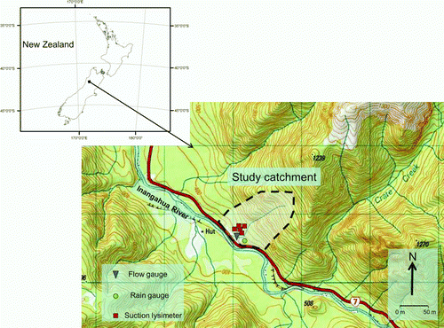
The field study was conducted within a headwater catchment (NZMS260 1516079E, 5319018N; drainage area, 148.8 ha), located on the north bank of the Inangahua River, in the West Coast region of New Zealand's South Island (). This catchment was characterised by steep topography, covered with mixed beech forest (Nothofagus spp.). The regional, underlying geology comprised principally weathered granite conglomerate, and the catchment was dominated by very rocky, well draining, steepland soils (Katrine soil series—silt loam, sandy loam to stony loam; Landcare 2010). This catchment is subject to periodical aerial 1080 applications. A small (<1 m wide) first-order stream drains the catchment directly into the Inangahua River. An automated, tipping bucket rain gauge and a pressure transducer, recording the head of water in the stream, were used to measure rainfall and stream stage, respectively. These data were collected at 15-min intervals from 24 August to 2 September 2009, the duration of our field study. Streamflow was also manually gauged five times during high and low flow periods to develop a stage-discharge rating curve. During the field study, we did not find any observable changes in stream bed (e.g. scouring or deposition), and hence, concluded the five manual gaugings sufficiently represented the flow conditions of that time.
Figure 2 Study catchment locator map.
Five suction lysimeters were placed throughout the lower part of the catchment (within 20 m radius from each other), to collect soilwater samples. The suction lysimeters consisted of a PVC tube sealable at the top with a single-hole rubber stopper and a porous ceramic cup (40 mm diameter by 61 mm long) at its base. Suction was applied from the top, allowing soilwater to pass through the ceramic cup into the PVC tube. Prior to installation, the porous base of the lysimeter was soaked in distilled water for a minimum of 15 min to ensure good hydraulic contact between the ceramic cup and the surrounding soil. Any gaps on the surface around the lysimeter and the soil were sealed with bentonite clay to prevent edge flow. The lysimeters were installed to a depth of 150–200 mm (porous cup located at 150–200 mm).
All the lysimeters were located within 20 m from the stream. According to the CCA concept used in our model, this near-stream corridor actively contributes to overland flow during rainfall events, potentially transporting water and 1080 via overland to streams. The soilwater samples drawn from these near-stream lysimeters captured 1080 leaching, if any, occurring with infiltrating rainfall. The soilwater samples collected represented the 1080 sampled at a specific depth (here, 150–200 mm below surface), did not account for soil properties influencing 1080 leaching.
The cereal 1080 baits (Wanganui No. 7, 0.15% w/w 1080) were aerially applied, at a rate of 2.5 kg/ha on 24 August at 10:00 h, 1 day prior to a significant rainfall forecast. By planning the aerial application closer to a rainfall event, we were able to minimise any possible degradation or consumption of 1080 baits, and focus primarily on release of 1080 related to rainfall, and its transport to streams.
Grab samples of stream water were collected at regular intervals prior to, during and after the rain event in acid-washed 250-ml polyethylene bottles. Samples were immediately stored on ice to reduce the rate of 1080 decomposition, and subsequently frozen. The frequency of sample collection varied from the start to the end of the rainfall event (see and for sample dates and times). Since our model development assumed that overland flow dominated 1080 transport from land to streams, more samples were collected during rainfall events when surface run-off would be dominant. Once rainfall ceased, as streamflow started to recede, sampling frequency decreased. At the completion of the field study, the stream hydrograph was examined, and samples of interest (i.e. those collected throughout the rise and peak of the flow hydrograph) were identified and analysed.
Figure 3 Rainfall and streamflow hydrograph for the study catchment. Rainfall and flow were measured at 15-min interval. 1080 was applied on 24 August (shown by dotted-black arrow). For 3 h on 27 August, the pressure transducer recorded erroneous readings, and hence, a gap in the flow record. T0, T1, T2, T3 and T4 refer to soilwater and bait sampling times listed in .
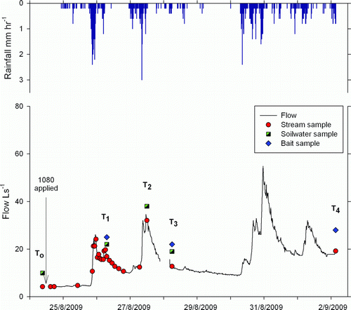
Table 1 Timing and in-stream 1080 concentrations for the samples collected during the field study.
Soilwater samples were collected four times throughout the study before and after application (T0, T1, T2 and T3; and ). Although baits were aerially applied throughout the catchment, examination of the immediate area surrounding the lysimeters indicated presence of no baits, despite baits being observed in other areas of the catchment. Therefore, to ensure a 1080 concentration ‘signature’ captured within the soilwater, a bait was placed on the soil surface approximately 200 mm upslope of each lysimeter. Soilwater was obtained by applying a vacuum (~60 centibars) to the lysimeter.
Table 2 Timing and concentrations of 1080 in soilwater samples and the persistence of 1080 in baits during the field study.
Stream and soilwater samples were stored at 80 °C prior to 1080 analysis using gas chromatography method (Ozawa & Tsukioka Citation1987). Analyses were carried out by Landcare Research (Lincoln, NZ), and the method detection limit (MDL) was 0.1 µg/l and 1080 recovery rate was 98% (Booth, Landcare, 2011; pers. comm.). The 1080 concentrations from each lysimeter samples were normalised by dividing the measured concentration by measured maximum concentration for that lysimeter. The normalised concentration varied from 0 (no 1080) to 1 (maximum concentration).
During the field study, 1080 baits were collected randomly at different times (T1, T3 and T4; and ) to analyse the persistence of 1080. Four baits were collected at each time. However, the baits placed next to the lysimeters remained undisturbed until the end of the study, and were only collected at time T4. The collected baits were stored at 80° C, and were analysed by the Animal Control Products (Wanganui, NZ) to quantify residual 1080 using the gas chromatography technique based on Method 8B of the Denver Wildlife Center. This method has a detection limit of 1 mg/kg and a recovery rate of 94.6% (Hall, Animal Control Products, 2011; pers. comm.).
Results
In-stream 1080 concentrations: modelling versus field studies
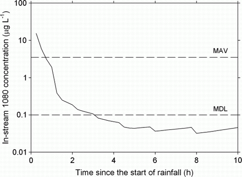
From 21:15 h 25 August to 05:00 h 26 August, approximately 34 h after the aerial application, a total of 28 mm was recorded in less than 8 h, with intensity varying from 0.8 to 9.6 mm/h. This rainfall event represented a return period of less than 2 years for this region (Thompson Citation2002). Daily soilwater balance (Kandel et al. Citation2005) during the study period (24 August–2 September 2009) was close to field capacity at the start, but increased to more than 40 mm above field capacity over the study period. Our model estimated 1080 concentrations in the stream to reach a maximum of 15 µg/l within 30 min from the start of rainfall, then fall below the Ministry of Health guideline standard (3.5 µg/l) 30–45 min later, and eventually below MDL (0.1 µg/l) in less than 2 h after. For the rest of the period, our model predicted that 1080 concentrations remained below MDL ().
Figure 4 Modelled in-stream 1080 concentrations for a rainfall event (28 mm over 8 h) that was monitored in the study catchment. MAV is maximum allowable value, set by the New Zealand Ministry of Health (3.5 µg/l) for 1080 in drinking water and MDL is method detection limit (0.1 µg/l). In our field study, only one stream sample contained a measurable concentration of 1080 (0.1 µg/l; collected 105 min from the start of rainfall), while 1080 was below detection limits (0.1 µg/l) in all other samples ().
During the field study, following the first rainfall event of 28 mm, an additional 100 mm rain fell over the next 9 days. Sampling continued during this period. A total of 25 stream water samples were collected, capturing baseflow conditions and a series of stormflow events that occurred over 10 days since the aerial application ( and ). From these, 17 samples were selected that best reflected the peaks and troughs throughout the hydrograph, and were subsequently analysed for 1080. In 16/17 samples analysed, 1080 concentrations were below MDL (0.1 µg/l). One sample with measurable 1080 concentration contained 0.1 µg/l, and was collected 105 min after the start of the first rainfall event on 26 August (). During this time 16 mm of rain had fallen.
1080 concentrations in soilwater
In the field, the soilwater yield from the five lysimeters varied spatially and temporally. For instance, no soilwater was obtained from two lysimeters during baseline sampling (T0), whereas 20–50 ml was obtained from the other three lysimeters. Analysis for 1080 within the soilwater was subsequently done only on samples obtained from these three lysimeters (referred as SW1, SW2 and SW3 in ). Over time, the difference between lysimeter yields remained variable, ranging from 50 ml to in excess of 300 ml. At T1, 1080 concentration varied by one order of magnitude between lysimeters, with 4 µg/l in SW2, and 20 and 61 µg/l in SW1 and SW3, respectively (nominal concentrations from field soilwater samples are shown in ). At T2, after a further 22.6 mm of rain had fallen, 1080 concentration in soilwater was lower than at T1, and differed between lysimeters by two orders of magnitude with 0.5 µg/l measured in SW2, 2 µg/l in SW1 and 30 µg/l in SW3. At T3, after a further 3.6 mm of rain, 1080 concentrations in soilwater were 17 and 53 µg/l from SW1 and SW3 respectively, while it was below MDL in SW2.
Persistence of 1080 in baits
Baits collected at different times during the field study were analysed to assess the persistence of 1080, and hence 1080 availability to transport over subsequent rainfall events (). Samples collected from the field indicated that 1203±85 mg/kg of 1080 from the baits had been released with 34.4 mm of rainfall occurring at an average intensity of less than 2 mm/h. The field samples were collected at different times (), and hence their exposure to catchment conditions also differed as well as the rainfall depths. After 60.6 mm rainfall, the field baits had released 1360±78 mg/kg. Analysis of baits collected from field 10 days after the aerial application indicated that almost all 1080 had left the baits (1499±1 mg/kg of 1080 had been released).
Discussion and summary
During the aerial application for our field experiment, no buffer strip was placed around the first-order stream. However, samples collected immediately following the aerial application, and prior to the rainfall event, indicated that 1080 concentration in the stream were below MDL. Absence of measurable 1080 concentrations in the stream immediately following aerial application indicated that by chance, few, if any, 1080 baits fell directly into the stream in this study, whereas Suren (Citation2006) observed that baits do fall into streams on occasion. Measureable 1080 concentrations (0.1 µg/l) in the stream sample 105 min after the rainfall event commenced suggested that this 1080 came from baits on land, rather than from baits that fell into the stream. This also suggests that the 1080 transport from land to streams could be occurring during the rainfall event, though the pathway of this transport can only be inferred, at this stage. Absence of measureable concentrations of 1080 in any of the other stream samples is indicative of either dilution of 1080 in streams to below MDL or that 1080 transport from land to streams was limited.
While our transport sub-model simulated a large 1080 concentration early during the rainfall event, it was not observed in the field study. This most likely reflects absence of significant amounts of 1080 available to transport early during the rainfall event, absence of significant overland flow early during the rainfall event to transport the released 1080, or both. The source sub-model was developed based on laboratory-scale simulated rainfall experiments, with 20 mm/h rainfall applied over 10 h (Bowen et al. Citation1995). However, during our field study, the maximum rainfall intensity did not exceed 12 mm/h, and the average intensity remained less than 5 mm/h. Suren (Citation2006), who studied 1080 release from cereal baits under running water conditions, reported release rates that were similar to those of Bowen et al. (Citation1995). Bowen et al. (Citation1995) also reported that 1080 is highly water soluble, and the baits can release 1080 into the environment with as little as 5 mm of rainfall. However, it is not known if the rates of 1080 release from baits at such low rainfall intensities as <5 mm/h are similar to those reported at 20 mm/h by Bowen et al. (Citation1995). If the release rates during our field study were smaller than those reported by Bowen et al. (Citation1995), that would explain an absence of 1080 in the water samples collected early during the rainfall event.
Visual observations during the field study indicated occurrence of several puddles across the lower end of the catchment that were connected to other puddles, and then to the stream. However, these puddles had not formed until after 60 mm of rainfall and 2 days after the first rainfall event (~4 days after aerial application). This saturated soil condition would have resulted in overland flow later during the storm but not early during the rainfall event when the soil was not completely saturated. This could have resulted in lower than predicted levels of overland flow and transport of 1080 to stream. Also, later during the rainfall event, when conditions were conducive to overland flow, dilution and/or reduced availability of 1080 to transport would have resulted in concentration below detection limits. However, in catchments where soils are shallow, where soils are saturated at the time of 1080 application and before the first rainfall event after application and where the water table is close to the surface, conditions conducive to overland flow could occur early during the rainfall events, possibly resulting in significant overland transport.
The occurrence of 1080 in soilwater samples collected during this study indicated the potential for 1080 to leach during rainfall. Thus, potential overland transport to streams of 1080 released within the near-stream corridor needs to be revisited. While no direct evidence for 1080 in overland flow was collected during the field study, presence of 1080 in soilwater indicated that not all 1080 released in these CCAs was transported overland, as was assumed in the transport sub-model.
The occurrence of saturation conditions and presence of puddles also appeared to have impacted the 1080 concentrations in the soilwater. For example, at SW2, ponded water was observed throughout the study and the soilwater concentrations were very low throughout, possibly because of dilution. Under field conditions, the variability among soilwater samples (i.e. volumes collected and 1080 concentrations) most likely reflects inherent soil and topographical heterogeneity. Because individual baits were placed adjacent to the lysimeters, we could not quantify the degree to which soilwater throughout the catchment was contaminated with 1080. Neither did we sample soilwater across the entire catchment to characterise the spatial and temporal variability of 1080 leaching. It is thus unknown how, or indeed whether, 1080 is transported widely in soilwater. In the absence of any significant overland flow early during the rainfall event, the single sample with measurable 1080 concentration could have come via subsurface flow to the stream, or from baits landed nearby the stream via overland flow. More research is thus required to assess the relative importance of these two different modes of transport of 1080 to surface waters. Also, 1080 concentrations in soilwater varied temporally. For instance, at SW1 and SW3, 1080 concentrations were greater at T3 than those at T2 (). In the absence of site specific knowledge of subsurface soil properties, it can be only be speculated that the 3.6-mm rainfall that occurred between T2and T3 could have resulted in less diluation at T3 than at T2 (between T1 and T2, 22.6 mm of rainfall had occurred; ). However, this was not observed at SW2. Also, subsoil heterogeneity could have resulted in different leaching rates between sites.
No previous studies (e.g. Eason et al. Citation1992; Bowman Citation1999) have reported occurrence of 1080 in groundwater, suggesting that 1080 in soilwater is greatly diluted and dissipated to below detection limits before reaching the water table. Affinity of 1080 to soil and degradation of 1080 in soils might also influence the eventual fate and transport of 1080. However, degradation and flowpaths of 1080 released into the soil have not yet been fully studied. In catchments where the water table could rise towards the surface during rainfall events, infiltrating 1080 could reach the groundwater before appreciable degradation. Additional data are needed to relate the role of infiltrating 1080 and its fate in soilwater and possible transport to groundwater.
This study reports the results of the most temporally detailed sampling programme to date investigating the fate of 1080 after aerial applications. Often, in majority of field studies reported in the literature, samples for 1080 have been collected only once, usually 12–24 h after application. Moreover, this study was designed to maximise the conditions where 1080 could be transported to surface water, with an aerial application of 1080 immediately before predicted rainfall. However, this is not normal operating procedure but was done to maximise 1080 transport to streams, thereby simulating the maximum likelihood contamination of streams. Our field experiment, which monitored 1080 concentration in water frequently after an aerial application and during a series of rainfall event that followed, recorded no significant 1080 contamination of stream. This further supports observations from the past where no significant 1080 contaminations were reported. Even though Bowen et al. (Citation1995) predicted quick and large release of 1080 early during rainfall events, in the absence of conducive overland flow conditions (puddles, saturated areas), released 1080 may not reach the streams quickly. However, as predicted by Parfitt et al. (Citation1994), the released 1080 showed propensity to leach into the soil, though its fate remains to be investigated.
Acknowledgements
We would like to thank the Animal Health Board, Wellington, New Zealand, for funding this study. Thanks to C. Pullen, TBFree West Coast and K. Steffard, Epro Limited, for coordinating the 1080 aerial application at our request, to L. Booth and L. Brown, Landcare, for their assistance with analysing water samples and to D. Hall, Animal Control Products Limited, for her assistance with analysing 1080 baits.
References
- Bong , CL , Cole , AL and Walker , JRL . 1979 . Effect of sodium monofluoroacetate (‘compound 1080’) on the soil microflora . Soil Biology and Biochemistry , 11 : 13 – 18 .
- Booth , LH , Fisher , P and Brown , L . 2007 . The 1080 debate—water monitoring after aerial application of 1080 baits for pest control—an update . New Zealand Water & Wastes Association Journal , 156 : 38 – 39 .
- Bowen , LH , Morgan , DR and Eason , CT . 1995 . Persistence of sodium monofluoroacetate (1080) under simulated rainfall . New Zealand Journal of Agricultural Research , 38 : 529 – 531 .
- Bowman , RG . 1999 . Fates of sodium monofluoroacetate (1080) following disposal of pest bait to a landfill . New Zealand Journal of Ecology , 23 : 193 – 197 .
- Chow VT, Maidment DR, Mays LW 1988 . Applied hydrology . New York , McGraw-Hill International Edition .
- Coleman JD, Morgan DR 2002 . Knowledge gaps in conventional control of possums. Landcare Research Report LCD0203/021, prepared for Animal Health Board , Wellington .
- Eason CT, Miller A, Ogilvie S, Fairweather A 2011 . An updated review of the toxicology and ecotoxicology of sodium fluoroacetate (1080) in relation to its use as a pest control tool in NZ . New Zealand Journal of Ecology 35 : 1 – 20 .
- Eason CT, Temple W. 2008 . Water sampling for sodium fluoroacetate (1080)—how much is enough? Water and Wastes in New Zealand . September . Pp. 32 – 36 .
- Eason CT, Morgan AJ, Wright GR 1994 . The fate of sodium monofluoroacetate (1080) in the stream water, and risks to humans . Human Experimental Toxicology 13 : 640 .
- Eason , CT , Wright , GR and Fitzgerald , H . 1992 . Sodium monofluoroacetate (1080) water-residue analysis after large-scale possum control . New Zealand Journal of Ecology , 16 : 47 – 49 .
- Foronda , NM , Fowles , J , Smith , N , Taylor , M , Temple , W and Darlington , C . 2007 . The use of myocardial and testicular end points as a basis for estimating a proposed tolerable daily intake for sodium monofluoroacetate (1080) . Regulatory Toxicology and Pharmacology , 47 : 29 – 36 .
- Fowles , CR and Williams , JR . 1997 . Water quality monitoring in relation to a possum control operation on Mount Taranaki/Egmont . New Zealand Natural Science , 23 : 93 – 99 .
- Freeze , AR . 1974 . Streamfow generation . Reviews in Geophysical and Spatial Physics , 12 : 627 – 647 .
- Gburek , WJ , Drungil , CC , Srinivasan , MS , Needelman , BA and Woodward , DE . 2002 . Variable-source-area controls on phosphorus transport: bridging the gap between research and design . Journal of Soil & Water Conservation , 57 : 534 – 543 .
- Haan , CT , Barfield , BJ and Hayes , JC . 1994 . Design hydrology and sedimentology for small catchments , California : Academic Press .
- Hamilton , DJ and Eason , CT . 1994 . Monitoring for 1080 residues in waterways after a rabbit-poisoning operation in Central Otago . New Zealand Journal of Agricultural Research , 37 : 195 – 198 .
- Kandel D, Chiew F, Grayson R 2005 . A tool for mapping and forecasting soil moisture deficit over Australia . Monash University , Victoria , Cooperative Research Centre for Catchment Hydrology .
- King DR, Kirkpatrick WE, Wong DH, Kinnear JE 1994 . Degradation of 1080 in Australian soils. In: Seawright AA, Eason CT ed. Proceedings of the science workshop on 1080 . Wellington , The Royal Society of New Zealand, Miscellaneous Series 28 . Pp. 45 – 49 .
- Landcare . 2010 . New Zealand Land Resources Inventory database . http://www.landcareresearch.co.nz/databases/nzlri.asp (accessed 1 May 2010) .
- Ministry of Health . 2008 . Drinking-water Standards for New Zealand 2005 (Revised 2008) . Wellington , Ministry of Health . http://www.moh.govt.nz/water(accessed 1 May 2010) .
- Ozawa , H and Tsukioka , T . 1987 . Gas chromatographic determination of sodium monofluroacetate in water by derivation of dicyclohexyl-carbodiimide . Analytical Chemistry , 59 : 2914 – 2917 .
- Parfitt RL, Eason CT, Morgan AJ, Wright GR, Burke CM 1994 . The fate of sodium monofluoroacetate (1080) in soil and water. In: Proceedings of the science workshop on 1080 . Seawright AA, Eason CT The Royal Society of New Zealand Miscellaneous series 28 . Pp. 59 – 66 .
- Soil Conservation Service . 1972 . Hydrology . In: National engineering handbook, Section 4 . Washington , DC , USDA Soil Conservation Service .
- Srinivasan MS, McDowell RW 2009 . Identifying critical source areas for water quality: 1. Mapping and validating transport areas in three headwater catchments in Otago , New Zealand. Journal of Hydrology doi: 10.1016/j.jhydrol.2009.09.044 .
- Suren , AM . 2006 . Quantifying contamination of streams by 1080 baits, and their fate in water . New Zealand Journal of Marine and Freshwater Research Res , 40 : 159 – 167 .
- Thompson , C . 2002 . High Intensity Rainfall Design Systems (HIRDS)—Version 2.00 , Wellington : National Institute of Water & Atmospheric Research Ltd .