
Abstract
Nagra, the National Cooperative for the Disposal of Radioactive Waste, in Switzerland, is realizing a project of the century: the planning, construction, operation, and closure of a deep geological repository (DGR) for the nation’s radioactive waste. The site selection process for a DGR is regulated by a three-stage process described in the Sectoral Plan, which the Federal Government approved in 2008. An overconsolidated shale, the Opalinus Clay, was selected as the most suitable rock formation as a result of Stage 2 of the Sectoral Plan. The three remaining siting regions were investigated in detail during Stage 3, including more than 12.5 km of exploratory boreholes drilled since 2018 and high-resolution, three-dimensional seismic surveys covering an area of approximately 250 km2. In September of 2022, Nagra proposed Nördlich Lägern as the preferred siting region for a combined repository in Northern Switzerland. Nagra plans to submit the corresponding general license application to the authorities by the end of 2024.
I. INTRODUCTION
Nagra, the National Cooperative for the Disposal of Radioactive Waste, is responsible for the disposal of all radioactive wastes generated in Switzerland. According to Swiss legislation (the “Nuclear Energy Act”[Citation1]), these will be disposed of in a deep geological repository (DGR). The associated “Nuclear Energy Ordinance”[Citation2] specifies the objectives and criteria of the site selection process for a DGR in Switzerland in a Sectoral Plan,[Citation3] which was approved by the Federal Government in 2008. The Swiss Federal Office of Energy leads this stepwise process, with Nagra as the implementer and the Swiss Federal Nuclear Safety Inspectorate as the national regulatory body responsible for the nuclear safety and the security of Swiss nuclear facilities.
Further details about Nagra’s initial blank-map and ensuing stepwise narrowing-down approach used for the site selection process for a DGR in Switzerland can be found in Ref. [Citation4].
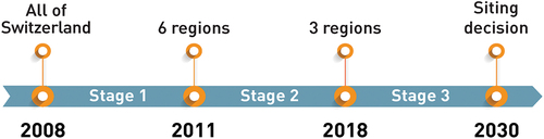
The Federal Council of Switzerland approved Stage 1 of the site selection process in December 2011 and Stage 2 in November 2018 (see ).
Fig. 1. Timeline of the different stages of the stepwise site selection process for a DGR in Switzerland (not displayed: Nagra’s announcement of the siting proposal in September 2022).
For all remaining siting regions, an overconsolidated (approximately 175-million-year-old) shale, the Opalinus Clay, was selected to host a DGR. The suitability[Citation5] of this rock formation[Citation6] was proven based on properties such as its self-sealing capacity, sorption capability, and very low permeability.
II. SITE INVESTIGATIONS
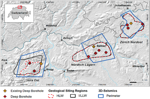
To strengthen previous site investigations such as the two-dimensional (2D) seismic surveys conducted in 2011 and 2012, the three siting regions in Northern Switzerland (see ) remaining after the conclusion of Stage 2 were further investigated during Stage 3 of the Sectoral Plan.
Fig. 2. The three siting regions in Northern Switzerland with the locations of the successfully completed 3D seismic surveys and Nagra’s deep exploratory boreholes.
II.A. Three-Dimensional Seismic Surveys
From October 2015 until February 2016, a three-dimensional (3D) seismic survey extending over approximately 92.6 km2 was conducted in the Jura Ost siting region. To complete the 3D seismic acquisition for the Zürich Nordost siting region that had initially covered approximately 48.3 km2 in 1997, a second 3D seismic survey was performed in March 2016 to cover the remaining approximately 18.3-km2 section. Finally, from October 2016 until February 2017, a 3D seismic survey extending over approximately 91.2 km2 was conducted in the Nördlich Lägern siting region.
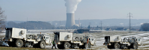
For the surveys conducted between 2015 and 2017, a total of 53 municipalities and around 4000 landowners were contacted and informed. About 98% of the landowners allowed Nagra to place source and/or receiver points on their property. Overall, in total, approximately 51 460 receiver points (with an average line spacing of 120 to 150 m) and approximately 40 950 source points (with an average line spacing of 150 to 180 m) were placed. Seismic excitation of around 85% of these points was generated by vibration vehicles (see ); explosives were used for the remaining points. The recording frequency of the geophones was 0 to 200 Hz.
Fig. 3. Seismic acquisition by vibration vehicles using a frequency of 10 to 120 Hz (photograph courtesy of B. Müller).
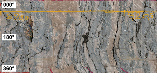
Details on Nagra’s 3D seismic measurements covering a total area of approximately 250 km2 in Northern Switzerland can be found in Ref. [Citation7]. All seismic marker horizons were mapped with high confidence and with high resolution. Birkhäuser et al.[Citation8] demonstrated that faults with vertical offsets down to approximately 10 m can be successfully identified and geometrically described by tracing offsets in the flat-lying sedimentary layers.
II.B. Quaternary Investigations
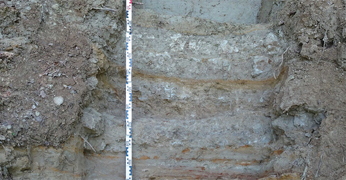
Sedimentary deposits from the Quaternary (the most recent geological period from around 2.5 million years to the present) provide information on past erosion processes and potential tectonic activity. For this reason, Nagra has investigated these sediments with geophysical methods, such as high-resolution 2D seismic surveys and passive seismic measurements, as well as with direct investigation methods such as trenches (see ) and boreholes.
Fig. 4. Example of a trench in Quaternary sediments.
Between March 2018 and December 2020, 12 vertical boreholes with a total depth of approximately 1845 m were drilled in the Quaternary sediments in Northern Switzerland. All boreholes reached into the underlying rock formations, which, depending on their location in relation to the glacially over-deepened valleys and paleochannels, resulted in a maximum depth of approximately 325 m. The core material (see ) from these boreholes was investigated in detail, i.e., with a multi-sensor core logger, and dated whenever possible, as described in Ref. [Citation9]. Further details on these investigations can be found in Nagra Technical Report NTB 21-02.[Citation10]
Fig. 5. Drill core from an unsorted glacial till.
II.C. Deep Exploratory Boreholes
After the completion of the 3D seismic surveys, the Mesozoic sedimentary layers, including the host rock formation Opalinus Clay, were intensively investigated by drilling nine deep exploratory boreholes (see ). This drilling campaign started in spring 2019 and was successfully completed in spring 2022 without any major incidents or interruptions, for example, due to COVID19.
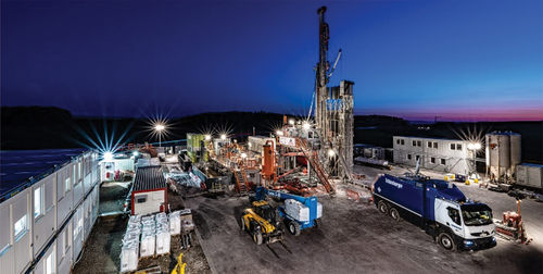
Two drilling rigs (see ) were operated simultaneously on a 24/7 schedule, resulting in a total borehole length of approximately 10.7 km of which about 60% was wireline cored with a triple core barrel system, including a protective plastic liner. To reduce unwanted swelling of clay-rich rock formations and thus improve borehole stability in these sections, a special drilling fluid containing potassium silicate and polymers was used.
Fig. 6. Geophysical wireline logging at one of the two rigs in operation for Nagra’s deep exploratory drilling campaign.
After cleaning and initial documentation (see ), all drill cores were scanned using an optical scanner with a specially calibrated illumination system developed by Nagra. Whenever possible and especially for all sampled sections, a 360-deg unwrapped core scan was performed in high resolution (see ).
Fig. 7. Initial core documentation at a deep exploratory drill site (photograph courtesy of Comet Photoshopping GmbH).
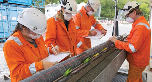
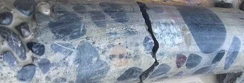
Fig. 8. Unwrapped (360-deg) high-resolution scan of a drill core from the deep exploratory drilling campaign.
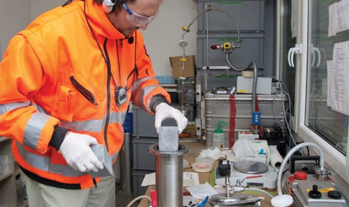
Approximately 4600 core samples were taken from the core material and sent to highly specialized laboratories for detailed measurements of mineralogical, geochemical, petrophysical, hydraulic, geomechanical, and other relevant properties. Different sample preservation and conservation methods were applied. For isotope analyses, for example, noble-gas-flushed steel containers (see ) were immediately filled at the drill site to prevent oxidation and other forms of contamination. On average, drill cores were sampled within approximately 30 min after core retrieval.
Fig. 9. Special protection of core samples in noble-gas-flushed steel containers for subsequent isotope analysis.
The following tests were successfully conducted in the mostly vertical deep exploratory boreholes that reached depths of up to approximately 1370 m below ground level: 140 micro-hydraulic fracturing tests (to assess minimum stress orientation and magnitude), 94 hydraulic packer tests (to assess hydraulic permeabilities and heads), and 6 gas injection tests (to assess the gas threshold pressure). The sampling and measurement methods applied as well as sample results from one of Nagra’s deep exploratory boreholes can be found in Nagra Work Report NAB 20-09.[Citation11]
III. RESULTS
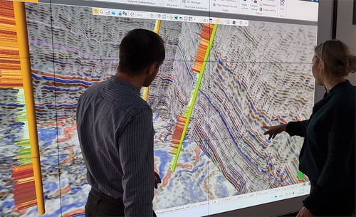
With the described site investigation program, Nagra collected an extensive, high-quality data set. Currently, all measurements are being analyzed and synthesized. With the help of software tools, all relevant information—especially from the approximately 65 km of geophysical wireline logging performed in the deep exploratory boreholes and from the seismic surveys—is being combined in Nagra’s special visualization laboratory (see ). The purpose of this “ViLab” is to generate geoscientific 3D models allocating geostatistical properties to each relevant rock formation.
Fig. 10. Nagra’s “ViLab” for 3D data visualization and interpretation of the collected seismic and borehole data.
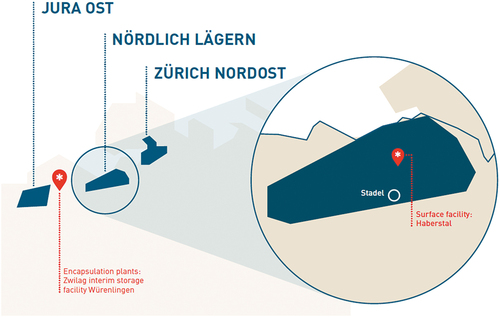
The accumulated information allows Nagra to compare the three remaining siting regions and to propose one site for a combined DGR (see ) for both low- and intermediate-level waste (L/ILW) and high-level waste (HLW). In September 2022, Nagra announced its siting proposal at a press conference. All three siting regions in Northern Switzerland fulfill the requirements for the construction of a combined DGR, but the Nördlich Lägern siting region is the most suitable. It is foreseen to place the surface facilities for the DGR in Haberstal close to the village of Stadel in the canton of Zürich and the encapsulation plants at the ZWILAG interim storage facility close to the village of Würenlingen in the canton of Aargau (see ).
Fig. 11. Sketch of a combined DGR in Switzerland.
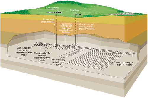
Fig. 12. Nagra’s siting proposal for a combined DGR in Northern Switzerland.
A report published in September 2022[Citation12] summarizes Nagra’s considerations, which are based mainly on three criteria: quality, stability and flexibility. These were the key factors designated to make the siting proposal more easily understandable to the public. However, Nagra’s proposal is based on 13 detailed criteria related to safety and engineering feasibility as laid out in the Sectoral Plan.[Citation3] While all three siting regions are equally suitable with regard to certain criteria, Nördlich Lägern is best suited to satisfy all of them.
III.A. Quality of the Geological Barrier
A large distance between the host rock and the nearest aquifers contributes to the containment of the waste and is an important argument with regard to the overall suitability of a potential siting region. The Opalinus Clay in Nördlich Lägern has the greatest distance to the nearest aquifers. In addition, ancient porewater in the Opalinus Clay, i.e., porewater that has been enclosed in the rock over a very long time, indicates a highly effective containment capacity.
III.B. Stability of the Geological Barrier
The Opalinus Clay has to safely enclose the waste not only for today but also for up to one million years. Natural influences such as erosion by glaciers and rivers can change the landscape at the surface and below ground. The host rock in Nördlich Lägern protects the repository from such processes, partly because of its greater depth of approximately 900 m. As a result, it ensures the greatest long-term stability.
III.C. Flexibility
Nördlich Lägern has the largest area suitable for the construction of a DGR, providing Nagra with the greatest degree of flexibility with regard to the layout. From Nagra’s point of view, the siting region of Nördlich Lägern has the best overall safety reserves and is therefore the most suitable site for a DGR.
IV. OUTLOOK
Nagra is in a position to successfully proceed with the next planning and licensing steps for a DGR in Northern Switzerland. Submission of the corresponding general license application to the authorities is foreseen by late 2024 (see ). The official review and approval process is expected to last about 6 years and might be followed by a public referendum at a national level.
Fig. 13. Planned completion timeline of a DGR in Switzerland.
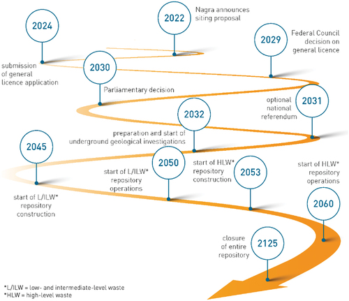
Preparation for the underground investigation program and initial construction works are foreseen to start in 2032. Further details regarding the Swiss waste management program can be found in Nagra Technical Report NTB 21-01.[Citation13]
Disclosure Statement
No potential conflict of interest was reported by the author(s).
References
- “Nuclear Energy Act” [“Kernenergiegesetz (KEG)”], Ratified on March 21, 2003, SR 732.1, Publication Platform for Federal Law,” Switzerland (2003); https://www.fedlex.admin.ch/eli/cc/2004/723/en.
- “Nuclear Energy Ordinance” [“Kernenergieverordnung (KEV)”], Ratified on December 10, 2004, SR 732.11, Publication Platform for Federal Law,” Switzerland (2004); https://www.fedlex.admin.ch/eli/cc/2005/68/en.
- “Sectoral Plan for Deep Geological Repositories—Conceptual Part,” Swiss Federal Office of Energy of the Federal Department of the Environment, Transport, Energy and Communications, Bern, Switzerland (2008); https://www.bfe.admin.ch/bfe/en/home/versorgung/kernenergie/radioaktive-abfaelle/sachplan-geologische-tiefenlager.exturl.html/aHR0cHM6Ly9wdWJkYi5iZmUuYWRtaW4uY2gvZW4vcHVibGljYX/Rpb24vZG93bmxvYWQvODE3MQ==.html.
- P. ZUIDEMA and S. VOMVORIS, “Site Selection in Switzerland: Stepwise Narrowing-Down Methodology and Its Application,” Proc. 16th Int. High-Level Radioactive Waste Management Conf., Charlotte, North Carolina, April 2017, American Nuclear Society ( 2017); https://www.ans.org/pubs/proceedings/article-43298/.
- “Projekt Opalinuston: Synthese der geowissenschaftlichen Untersuchungsergebnisse: Entsorgungsnachweis für abgebrannte Brennelemente, verglaste hochaktive sowie langlebige mittelaktive Abfälle,” NTB 02-03, Nagra, Wettingen, Switzerland (2003); https://nagra.ch/wp-content/uploads/2022/08/d_ntb02-003.pdf.
- “Clay Rocks and Their Contribution to Radioactive Waste Disposal,” Nagra, Wettingen, Switzerland (2020); https://nagra.ch/wp-content/uploads/2022/07/e_th12_Tongesteine.pdf.
- A. HÖLKER and P. BIRKHÄUSER, “3D-Seismik Datenbearbeitung 2016–2017,” NAB 17-36, Nagra, Wettingen, Switzerland (2018); https://nagra.ch/wp-content/uploads/2022/08/d_nab17-036.pdf.
- P. BIRKHÄUSER et al., “3D-Seismik: Räumliche Erkundung der mesozoischen Sedimentschichten im Zürcher Weinland,” NTB 00‑03, Nagra, Wettingen, Switzerland (2001); https://nagra.ch/wp-content/uploads/2022/08/d_ntb00-003.pdf.
- D. MÜELLER et al., “Luminescence Properties and Dating of Glacial to Periglacial Sediments from Northern Switzerland,” Geochronology, 2, 305 (2020); https://doi.org/10.5194/gchron-2-305-2020.
- “The Nagra Research, Development and Demonstration (RD&D) Plan for the Disposal of Radioactive Waste in Switzerland,” NTB 21-02, Nagra, Wettingen, Switzerland (2021); https://nagra.ch/wp-content/uploads/2022/08/NTB-21-02.pdf.
- “TBO Trüllikon-1-1: Data Report. Dossiers I to X + Summary Plot,” NAB 20-09, Nagra, Wettingen, Switzerland (2021); https://nagra.ch/en/downloads/arbeitsbericht-nab-20-09-2/.
- “The Site for the Deep Geological Repository—Nagra’s Proposal,” Nagra, Wettingen, Switzerland (2022); https://nagra.ch/wp-content/uploads/2022/09/Report-the-site-for-the-deep-geological-repository-Nagras-proposal.pdf.
- “Waste Management Programme,” NTB 21-01, Nagra, Wettingen, Switzerland (2021); https://nagra.ch/wp-content/uploads/2022/08/NTB-21-01E.pdf.