Abstract
The impact of soil erosion on the nutrient dynamics in alpine grassland soils is still an essential problem. Selecting a grass-covered hillslope in eastern Tibet Plateau, the cesium-137 (137Cs) technique was used to determine the impacts of soil erosion on soil organic carbon (SOC), total nitrogen (TN), total phosphorus (TP), and total potassium (TK). The 137Cs data revealed that there were distinct soil redistribution patterns in different hillslope positions because of the influences of slope runoff, plant coverage and grazing activity. For the upper slope, soil erosion first decreased downward, followed by soil deposition in its lower part. In contrast, for middle and toe slopes, there was an increasing soil erosion along a downslope transect. Across the lower slope, soil erosion showed an irregular variation. Influenced by the selective transport of water erosion, SOC, TN and TP storage decreased with increasing soil erosion in upper, middle and toe slopes. In contrast, SOC, TN and TP storage varied little with soil erosion in the lower slope. On the whole hillslope, TK storage also varied little with soil erosion due to the large amount of potassium elements derived from soil parent materials. Particularly noteworthy was the greatest storage of SOC, TN and TP in the lower slope where most obvious net soil erosion occurred, which is closely related to the humus accumulation combined with gravel separation as well as weathering and pedogenesis of parent rocks induced by soil freeze-thaw.
INTRODUCTION
Alpine grassland is a major type of ecosystem in the Tibetan Plateau, covering an area of 7.8 × 10⁷ ha, approximately 65.6% of the land area of the plateau (Zhong et al. Citation2008). The ecosystem plays important barrier functions in terms of ecological security, such as climate regulation, water and soil conservation, and biodiversity maintenance. But the alpine grassland is rather fragile and sensitive to exogenous disturbances, such as the intensive agriculture and soil erosion. It is well known that overgrazing and unreasonable land-use change have resulted in severe soil degradation in the alpine grassland of the Tibetan Plateau, China (Li et al. Citation2007; L.L. Yang et al. Citation2008; Nie et al. Citation2010). Fortunately, effective measures, such as the projects to reconvert the farmland into grassland and scientific grazing including fencing enclosure, rotational grazing and conservative grazing, have been carried out in the plateau to combat grassland degradation. However, little has been done to attend to the impacts of soil erosion on the soil degradation of alpine grassland in the plateau, especially in eastern Tibet which is characterized by alpine gorge geomorphology.
Soil erosion is one of the most severe natural disturbances to alpine grassland soil in eastern Tibet. Nowadays, more than 44% of the total land area of eastern Tibet is suffering from soil erosion and the dominant erosion type is water erosion (Zhong et al. Citation2008). Given the projected tendency of an increase in global temperature, an increase in snowmelt at higher latitudes will accelerate soil erosion and the consequent soil degradation of alpine grassland in the region.
There is a particular shortage of data concerning quantitative soil erosion assessment in eastern Tibet due to lack of long-term field observation. Despite the fact that satellite remote sensing techniques are popularly used to investigate soil erosion in the alpine gorge regions, this can only provide a qualitative description of soil erosion, not a quantitative evaluation. In comparison, the cesium-137 (137Cs) technique can overcome the limitations associated with the above-mentioned traditional approaches and has been proven effective in quantifying alpine soil erosion in the European Alps (Konz et al. Citation2012). 137Cs, an artificial radionuclide (half-life 30.2 a) produced by the nuclear tests that occurred between the 1950s and 1970s, fell on Earth's surface worldwide through atmospheric circulation transport and then was mixed into soil. By comparing 137Cs inventories of the study sites with those of reference sites, one can determine whether soil erosion (less 137Cs in study sites than in reference sites) or soil deposition (more 137Cs in study sites than in reference sites) has occurred. What's more, this method has proved to be a valuable tool for investigating the erosion-carbon relationship in different agricultural watersheds (Quine and Zhang Citation2002; Ritchie and McCarty Citation2003; J.H. Zhang et al. Citation2006a, Citation2006b; Mabit et al. Citation2008; Nie et al. Citation2010). In this study, we use the same methodology to evaluate the relationship between erosion and nutrient dynamics in the alpine grassland soil of eastern Tibet.
Soil nutrient dynamics in alpine freeze-thaw landscapes are the focus of much current research. Soil freeze-thaw is an important ecological process in alpine areas (Sjursen et al. Citation2005). Previous studies demonstrated that freeze-thaw cycles promote gaseous emissions such as nitrous oxide and carbon dioxide (Teepe et al. Citation2000; Priemé and Christensen Citation2001; Fitzhugh et al. Citation2003; Callesen et al. Citation2007), and enhance the magnitudes of water-soluble organic carbon, nitrogen (N), and phosphorus (P) (Fitzhugh et al. Citation2001; Watmough et al. Citation2004; Freppaz et al. Citation2007) in alpine soils. Except for freeze-thaw cycles, the impacts of soil erosion on soil nutrient dynamics in alpine freeze-thaw landscapes should not be neglected, whereas the relevant information is largely absent. The absence could be adverse to sustainable agriculture in alpine regions such as eastern Tibet where freeze-thaw area covers 48% of the land surface (Zhong et al. Citation2008).
Against this background, the objectives of this study were (1) to quantify the rates of soil erosion and deposition at different landscape positions using the 137Cs technique, (2) to examine the distribution of soil organic carbon (SOC), total nitrogen (TN), total phosphorous (TP) and total potassium (TK) along an eroded hillslope and (3) to determine the impacts of soil erosion on the nutrient parameters in an alpine grassland soil. The results may provide insights for enhancing the ecological security of alpine grassland ecosystems in eastern Tibet.
MATERIALS AND METHODS
Study area
The Aixigou small watershed (98°27'–98°36' E, 31°28'–31°39' N) with an expansion of 164.23 km2, located at Jiangda Couty of eastern Tibet, was selected as the study area. With elevations from 3320 to 4940 m above mean sea level, the area is of typical alpine gorge geomorphology. The study area has a semi-humid temperate climate with a mean annual temperature of 4.5°C (range, –15 to 28°C), an annual precipitation of 550 mm, mostly (77.9–95.8%) falling between May and September, and an annual evaporation of 1600–1700 mm. There is a short period of strong wind with a velocity of 17 m s−1 of about 45 d per annum but a long frost period of about 150 d. The dominant natural ecosystems include forest and grassland. Alpine meadow is the major natural vegetation in the grassland ecosystem with about 40–90% vegetation coverage, dominated by Kobresia pygmaea (C.B. Clarke), Kobresia humilis (C. A. Mey ex Trauvt.) Sergievskaya and Stipa purpurea Griseb. The soils are derived from slope materials of slate, phyllites, and magmatic rock, and are classified as alpine meadow soil in Chinese soil taxonomy (or felty soil, comparable to cambisols in the soil classification system by Food and Agriculture Organization of the United Nations, and United Nations Educational, Scientific, and Cultural Organization). Eroded soils on the hillslope in the study area are characterized by a thin soil layer (20–35 cm), underlain by a rock stratum.
Soil sampling
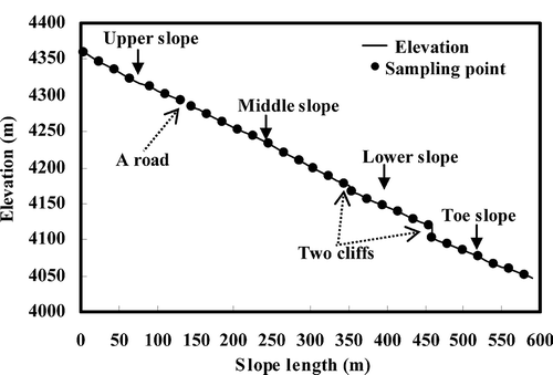
A grass-covered hillslope with a gradient of 31° and a slope length of 590 m was selected from the study area to conduct soil sampling. The hillslope is divided into four segments by a road at 138–145 m of the slope length and two cliffs at the positions 350–355 m and 459–460 m of the slope length, respectively, i.e., upper, middle, lower, and toe slope (). The grassland on the hillslope belongs to a seasonal freeze-thaw landscape, where the depths of the thaw layer and freeze layer are less than 50 cm. Field investigation found that the lower slope (elevation: 4046–4166 m above sea level) has apparent characteristics of soil freeze-thaw, i.e. bulged divots with a stripped distribution (length: 0.5–1 m, width: 15–20 cm, height: 16–20 cm) and stagnant water, whereas the characteristics are not obvious in other positions of the hillslope. The soils in the lower slope are clay loam (25% clay, 37% silt and 38% sand) with a pH of 5.65, and the soils in other hillslope positions are loam clay (27–28% clay, 35–40% silt, 33–38% sand) with a pH of 5.44–5.92.
Figure 1 The selected toposequence and sampling points.
The samples were collected at 20-m intervals along a downslope transect using a soil corer (6.8-cm diameter). The coordinates of each sampling point as well as the elevation were measured using a survey-grade Differential Global Positioning System (DGPS). For each sampling point, three soil cores were collected to depths ranging from 0–20 cm to 0–35 cm depending on soil thickness above parent material, and then bulked to make a composite sample. There were 31 composite samples, i.e., 31 sampling points along the hillslope transect. In addition, plant coverage was measured using the digital photography method reported by X.X. Zhang et al. (Citation2008). Down each hillslope segment, six vegetation quadrats of 1 × 1 m2 were selected at random and were photographed in situ. ENVI (Environment for Visualizing Images) remote sensing image processing system was adopted for distortion correction of the obtained pictures and to identify spectral information about vegetation and bare soil, whereby plant coverage was estimated.
Permanent pastures or forests can be used to assess the reference inventory of 137Cs fallout (Sutherland Citation1996; Owens and Walling Citation1996). However, no grassland left undisturbed and non-eroded since the early 1950s could be found in the Aixigou small watershed. For that purpose, the 137Cs reference inventory was estimated at undisturbed, non-eroded and flat forest sites in the watershed where the vegetation is dominated by Picea asperata Mast., Betula platyphylla Suk, Salicaceae, Caragana sinica (Buc'hoz) Rehder and Potentilla fruticosa L. A mean of 2387 Bq m−2 (s.d. ± 208 Bq m−2, n = 12) was determined as the reference inventory in the present study.
Laboratory analysis
Soil samples were air-dried, crushed, passed through a 2-mm mesh sieve to remove coarse material, and then divided into two parts, one for the measurement of 137Cs activity, and the other for SOC, TN, TP, TK and soil particle-size fractions. Samples for the < 2-mm fraction were sealed in a 200-cm3 (Φ 101 mm by 25 mm) plexiglass box. Twenty-eight days later, 137Cs activity of these samples was measured using a hyperpure lithium-drifted germanium detector linked to a LabSOCS (CANBERRA, USA) with a counting time of 36,000–86,400 s and a measurement precision of ca. ± 4.7% (95% confidence). The concentrations of 137Cs were originally expressed on a unit mass basis (Bq kg−1), and then were converted into an area basis (Bq m−2) using the total weight of the bulked core sample and the cross-sectional area of the sampling device. Soil bulk density (Mg m−3) calculations were based on volume of bulked soil cores and oven-dried mass determinations. The SOC was determined using wet oxidation with potassium dichromate (K2Cr2O7), and the measurement of TN followed the classical Kjeldahl digestion method (Liu Citation1996). The determination of TP and TK was carried out by sodium hydroxide (NaOH) digestion and an ammonium acetate extraction method, respectively (Liu Citation1996). Soil particle-size fractions were determined by the pipette method following hydrogen peroxide (H2O2) treatment to destroy organic matter and dispersion of soil suspensions in Na-hexametaphosphate (Liu Citation1996).
Statistical analysis
Statistical analysis was performed with SPSS for Windows version 11.0 (SPSS Inc., USA, 2002). Simple correlation analysis was carried out to test the relationships between 137Cs, soil fine particles, nutrient parameters and SOC/TN ratio at different positions of the hillslope. Analysis of variance (ANOVA) was used to compare the data, and to test the significance of differences between different slope positions.
RESULTS
137Cs distribution and soil erosion
There was a great variation in 137Cs inventories, ranging from 313 to 3556 Bq m−2 (mean, 1485 Bq m−2) in the whole hillslope landscape (). Higher 137Cs inventories (mean, 3130 Bq m−2; range 2591 to 3242 Bq m−2) higher than the 137Cs reference value of 2387 Bq m−2 occurred in the lower part (slope length, 90–130 m) of the upper slope (), indicating the occurrence of soil deposition there. However, in other positions of the hillslope, soil erosion had been identified by comparing the in situ 137Cs data with the 137Cs reference inventory (). The most severe soil erosion appeared in the lower slope where the mean 137Cs inventory (1122 Bq m−2) was the smallest. Moreover, 137Cs inventories in the lower slope were significantly lower than those in the upper slope (P < 0.05) but insignificantly lower than those in the middle and toe slopes (P > 0.05) ().
Table 1 Landscape elements, cesium-137 (137Cs) inventories, and soil nutrient levels
Figure 2 Distribution of cesium-137 (137Cs) inventory along the hillslope.
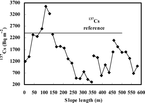
Despite the great variations in 137Cs inventory over the whole hillslope, some distinctive patterns can be observed at different hillslope segments (). In the upper slope, 137Cs inventory increased linearly with slope length (r = 0.95, P < 0.01), showing a decreasing soil erosion along a downslope transect, and even deposition in its lower parts. In contrast, in the middle and toe slopes, 137Cs inventory decreased linearly with slope length (middle: r = –0.95, P < 0.01; toe: r = –0.93, P < 0.01), indicating an increasing soil erosion along a downslope transect. In the lower slope, the distribution of 137Cs inventory was scattered and no correlation existed between 137Cs inventory and slope length (r = –0.09, P > 0.05).
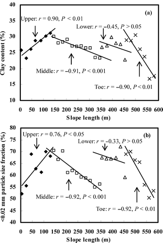
shows the distribution patterns of fine soil particles at the different hillslope segments. In the upper slope, clay content (< 0.002 mm soil particles) gradually increased down the slope, as shown by its positive correlation with slope length (r = 0.90, P < 0.01) (). In the middle and toe slopes, clay content decreased linearly downslope, with r = –0.91, P < 0.001 for the middle slope and r = –0.90, P < 0.01 for the toe slope (). Likewise, the percentage of the < 0.02-mm soil particles including clay and silt increased down the upper slope (r = 0.76, P < 0.05), and decreased down the middle slope (r = –0.92, P < 0.001) as well as the toe slope (r = –0.92, P < 0.01) (). These results demonstrated that the fine soil particles were selectively transported downslope mainly by water within the upper, middle and toe slopes. However, in the lower slope, there was no obviously selective soil transportation of water erosion because of little variability in the fine particles with slope length (r = –0.45, P > 0.05 between clay and slope length; r = –0.33, P > 0.05 between < 0.02 mm particles and slope length).
Figure 3 Distribution of fine soil particles along the hillslope: (a) clay; (b) < 0.02 mm particles.
Soil nutrient dynamics
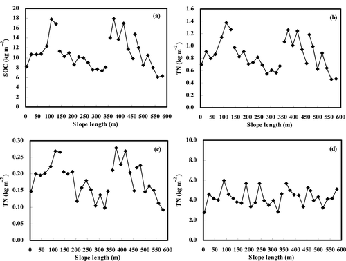
The average SOC, TN and TP contents over the whole hillslope were found to be 10.92, 0.86 and 0.18 kg m−2, respectively, and showed a wide variation (with a coefficient of variation (CV) of 30%, 29% and 29% for SOC, TN and TP, respectively) compared to that of TK (mean, 4.30 kg m−2; CV, 19%). Significant differences in SOC, TN and TP were found among the four hillslope segments (P < 0.05); however, no statistically significant difference in TK content was identified (P > 0.05). The highest nutrient contents were found in the lower slope, with means of 14.03 kg SOC m−2, 1.04 kg TN m−2 and 0.22 kg TP m−2, while in the middle and toe slopes, the contents of SOC, TN and TP decreased by 33%, 28%, 27%, and by 35%, 30%, 27%, respectively (P < 0.05) (). The decrease in these contents became insignificant in the upper slope (P > 0.05).
On the whole hillslope, distinctive patterns observed in soil nutrient were the increase in the contents of SOC, TN and TP down upper slope, and meanwhile the decrease of these contents down middle and toe slopes (–c). However, in lower slope, the three changed very irregularly (–c). Additionally, the changes in TK contents were also quite irregular on the whole hillslope ().
Figure 4 Distribution of soil nutrient along the hillslope: (a) soil organic carbon (SOC); (b) total nitrogen (TN); (c) total phosphorus (TP); (d) total potassium (TK).
Relationship between nutrient dynamics and soil erosion
As shown in the previous section, SOC, TN and TP contents increased downslope in the upper slope while they decreased in the middle and toe slopes, similarly to the distribution pattern of 137Cs inventory. The correlation analysis also indicated that significant correlations existed between SOC, TN and TP contents and 137Cs inventory in upper, middle and toe slopes (). The results suggested that the storage of SOC, TN and TP increased downslope with decreasing soil erosion in the upper slope, while it decreased downslope with increasing soil erosion in the middle and toe slopes. On the contrary, no such correlation could be identified in the lower slope (), suggesting that the SOC, TN and TP storage varied very little with soil erosion intensity in the hillslope positions characterized by obvious freeze-thaw. TK storage and SOC/TN ratios were also found to have little variation with soil erosion intensity in all slope positions, as shown by the absence of a correlation between TK, SOC/TN and 137Cs ().
Table 2 Correlation coefficients (r) between soil nutrient contents (kg m−2) and cesium-137 (137Cs) inventories (Bq m−2) at different slope positions
showed different relationships between the movement of fine soil particles and the dynamics of soil nutrients on the hillslope. In the upper slope, the storage of SOC, TN and TP was found to be positively correlated with the content of clay (< 0.002 mm) rather than the total fine particles (< 0.02 mm). This indicates that the distribution of SOC, TN and TP storage in upper slope is closely linked with clay transportation by water erosion. Yet the change in SOC/TN ratio is associated with transportation of the total fine particles by water erosion only in the upper slope, as revealed by a positive correlation between the two parameters (r = 0.76, P < 0.05). In both the middle and toe slopes, the storage of SOC, TN and TP was strongly positively correlated with the content of the total fine particles compared with the clay, suggesting that the distribution of SOC, TN and TP storage in the two positions is dominated by the movement of the total fine particles by water erosion. However, the movement of fine soil particles didn't cause the changes in the ratios of SOC/TN in the two slope positions, as revealed by poor correlations between them. In the lower slope, there was no correlation between the four parameters (SOC, TN, TP, TK and SOC/TN) and fine soil particles. For TK, its storage was also not correlated with fine soil particles in each slope position.
Table 3 Correlation coefficients (r) between soil nutrient contents (kg m−2) and fine particles (%) at different slope positions
DISCUSSION
Slope runoff, plant coverage and grazing activity are essentially three major factors that impact soil redistribution patterns as 137Cs data revealed over the whole hillslope. Compared to the rest of the hillslope, the upper slope develops a weak ground runoff as well as good vegetation cover (60–90%) because of the difficulty of access by livestock, resulting in the weakest soil erosion there. Meanwhile, soil erosion decreased downward from the upper parts of the upper slope firstly, followed by soil deposition in the lower parts. This result is mainly attributed to an increase in vegetation coverage from 60% in the upper parts to 90% in the lower parts of the upper slope; thus the eroded soils from the upper parts were gradually deposited to the lower parts. In the middle and toe slopes, increasing soil erosion along a downslope transect was caused by increasing gathering of slope runoff, less sufficient vegetation coverage (36–45%) and overgrazing due to ease of access by livestock. Soil erosion varied irregularly in the lower slope, which is closely related to the disordered slope runoff pathway due to the rolling microtopography caused by the bulged divots there. Moreover, net soil erosion was most obvious in the lower slope, which could be ascribed to soil removal by ground cracking during the soil thawing period there. However, the 137Cs data reveal that there were lower 137Cs inventories in the lower part of the middle slope than in the lower slope (). Based on consecutive ground runoff from the upper slope, 137Cs inventories in the upper part of the lower slope should be lower than those in the lower part of the middle slope. Thus, soil deposition from the middle slope could be concluded in the lower slope. Lower slope gradient in the lower slope (28°) than in the middle slope (33°) also results in the possibility of soil deposition. In addition, there were higher 137Cs inventories in the upper part of the toe slope compared with in the lower slope, probably showing soil erosion from the lower slope to the toe slope.
In our study, average SOC content over the whole hillslope was 10.92 kg m−2, which is in good agreement with that (9.3–12 kg SOC m−2) of alpine grassland soils in Qinghai-Tibetan Plateau (Wu et al. Citation2003; G.X. Wang et al. Citation2008). Meanwhile, the mean TN content was 0.86 kg m−2 in this study, close to that of 0.80 kg m−2 in alpine meadow soils reported by Y.H. Yang et al. (Citation2007). However, the mean TP content was 0.18 kg m−2, remarkably lower than that of 0.28 kg m−2 in alpine meadow soils obtained from the Second National Soil investigation (T. Wang et al. Citation2008). This mainly depends on poor phosphorus content (0.02%) in parent materials of the studied meadow soil in comparison with other alpine meadow soils (Bureau of Land Management in Tibet Autonomous Region Citation1994).
The storages of SOC, TN and TP were positively correlated with 137Cs inventories in upper, middle and toe slopes. This result is consistent with previous studies conducted in alpine regions such as the Qinghai-Tibetan Plateau (J.H. Zhang et al. Citation2006a; Nie et al. Citation2010) and non-alpine agricultural areas (Ritchie and McCarty Citation2003; J.H. Zhang et al. Citation2006b), suggesting that SOC, TN and TP storage decrease with increasing soil erosion intensity. The impact of soil erosion led to significantly lower storage of SOC, TN and TP in the middle and toe slopes than in the upper slope. However, the dynamics of TP is also affected by the characteristics of livestock behavior patterns. Obviously, severe grazing intensity in the middle and toe slopes compared with the upper slope also reflects the differences in SOC, TN and TP storage. In addition, the impact of soil erosion mainly depends on selective soil transportation by water erosion in our study. The spatial distribution of SOC, TN and TP storage in the middle and toe slopes was dominated by the movement of total fine particles (< 0.02 mm), while their distribution in the upper slope was controlled by the movement of clay (< 0.002 mm). Thus, it can be seen that the movement of fine soil particles by water erosion was more intensive in the middle and toe slopes, which is attributed to lower plant coverage in these two slope positions (36–45%) than in the upper slope (60–90%). A significant correlation between SOC/TN ratio and fine soil particles only occurred in the upper slope, which might be due to the weak intensity of fine particle movement caused by high plant coverage there. However, a poor relationship was found between the TK dynamics and soil erosion across the whole hillslope, which can be ascribed to the large amount of potassium elements (3.15%) in the soil parent materials in our study site that contain minerals such as muscovite and potassium feldspar (Bureau of Land Management in Tibet Autonomous Region Citation1994).
In the lower slope, we found distinctive dynamics of SOC, TN, and TP, i.e., no correlation between 137Cs, fine soil particles and SOC, TN or TP, and the greatest storage of SOC, TN and TP. No correlation between them in the lower slope could be attributed to soil deposition from the middle slope and soil erosion to the toe slope, as mentioned in the preceding text. In the lower slope, we found the greatest storage with 14.03 kg m−2 SOC, 1.04 kg m−2 TN, and 0.22 kg m−2 TP, which are quite close to those (15.70 kg m−2 SOC, 1.26 kg m−2 TN, and 0.25 kg m−2 TP) in slope positions with net soil deposition (90–130 m from the summit). In particular, SOC storage in the slope position was almost the same as that (14.4 kg m−2) of the wetland soils in the Arctic regions (Bockheim et al. Citation2004). The high values of the three parameters can be explained as follows. First, in the lower slope characterized by obvious soil freeze-thaw, the soil anaerobic conditions caused by more moisture increase the accumulation of semi-digested plant remains that is one of the major formation processes of alpine meadow soil (Bureau of Land Management in Tibet Autonomous Region Citation1994). Second, in our investigation, the gravel (> 2 mm) contents (mean, 13%) in soil profiles of the lower slope were found to be obviously lower than those (mean, 30%) of the upper, middle and toe slopes due to more intensive gravel separation by freeze-thaw. This improves soil structure in the lower slope. Third, more intensive soil freeze-thaw in the lower slope accelerates the weathering and pedogenesis of the parent rocks, which effectively offsets the removal of eroded soils.
However, soil freeze-thaw increases the gaseous emissions and enhances the contents of water-soluble nutrients, commonly resulting in net nutrient loss from alpine soils (Henry Citation2007). Therefore, the adverse impacts of freeze-thaw on alpine grassland soil should not be neglected in slope landscapes with obvious soil freeze-thaw. In particular, freeze-thaw erosion and gully erosion could be triggered as a result of an elongated soil-thawing period under global climate warming. It can also be expected that disastrous soil nutrient loss would happen in slope landscapes with obvious soil freeze-thaw, which is supported by the fact that both freeze-thaw erosion and gully erosion have been widely observed in other freeze-thaw landscapes of alpine gorge regions in the eastern Tibetan Plateau.
CONCLUSIONS
In the steep hillslope landscape of the eastern Tibetan Plateau, the impacts of soil erosion on the dynamics of alpine soil nutrient are different between slope positions with different plant coverage, livestock behavior, and freeze-thaw intensity. The impact of soil erosion on SOC, TN and TP is severe in slope positions with low vegetation coverage and intensive grazing when compared to slope positions with high vegetation coverage and slight grazing intensity. In slope positions without obvious soil freeze-thaw, the storage of SOC, TN and TP decreases with increasing soil erosion due to selective soil transportation via water erosion. In contrast, SOC, TN and TP storages varies little with soil erosion in slope positions characterized by obvious soil freeze-thaw. Moreover, the highest storage of SOC, TN and TP is found in slope positions characterized by obvious soil freeze-thaw, which is closely linked with humus accumulation, gravel separation and weathering and pedogenesis of parent rocks caused by freeze-thaw cycles.
ACKNOWLEDGMENTS
This work was jointly supported by the National Natural Research Foundation of China (No. 41001157 and 31140039), the Science and Technology Project of China (No. 2007BAC06B06 and 2007BAC06B08), and a Doctoral Program Foundation of Henan Polytechnic University grant given to Xiaojun Nie (No. B2010–47). We also thank Ms. S.Z. Liu, Mr. X.D. Wang and Mr. S.X. Gu for their assistance with experimental design and soil testing.
Related Research Data
REFERENCES
- Bockheim , JG , Hinkel , KM , Eisner , WR and Dai , XY . 2004 . Carbon pools and accumulation rates in an age-series of soils in drained thaw-lake basins, arctic Alaska . Soil Sci. Soc. Am. J. , 68 : 697 – 704 .
- Bureau of Land Management in Tibet Autonomous Region . 1994 . The Tibet Autonomous Region Species , 32 – 87 . Science Press, Beijing (in Chinese .
- Callesen , I , Borken , W , Kalbitz , K and Matzner , E . 2007 . Long-term development of nitrogen fluxes in a coniferous ecosystem: Does soil frost trigger nitrate leaching? . J. Plant Nutr. Soil Sci. , 170 : 189 – 196 .
- Fitzhugh , RD , Driscoll , CT , Groffman , PM , Fahey , TJ , Tierney , GL and Hardy , JP . 2001 . Effects of soil freezing disturbance on soil solution nitrogen, phosphorus, and carbon chemistry in a northern hardwood ecosystem . Biogeochemistry , 56 : 215 – 238 .
- Fitzhugh , RD , Driscoll , CT , Groffman , PM , Tierney , GL , Fahey , TJ and Hardy , JP . 2003 . Soil freezing and the acid-base chemistry of soil solutions in a northern hardwood forest . Soil Sci. Soc. Am. J. , 67 : 1897 – 1908 .
- Freppaz , M , Williams , BL , Edwards , AC , Scalenghe , R and Zanini , E . 2007 . Simulating soil freeze/thaw cycles typical of winter alpine conditions: Implications for N and P availability . Appl. Soil Ecol. , 35 : 247 – 255 .
- Henry HAL . 2007 . Soil freeze-thaw cycle experiments: Trends methodological weaknesses and suggested improvements . Soil Biol. Biochem. , 39 : 977 – 986 .
- Konz , N , Prasuhn , V and Alewell , C . 2012 . On the measurement of alpine soil erosion . Catena , 91 : 63 – 71 .
- Li , XG , Li , FM , Rengel , Z , Zhan , ZY and Bhupinderpal , S . 2007 . Soil physical properties and their relations to organic carbon pools as affected by land use in an alpine pastureland . Geoderma , 139 : 98 – 105 .
- Liu , GS . 1996 . Soil Physical and Chemical Analysis and Description of Soil Profiles , 123 – 166 . Beijing : Chinese Standard Press . (in Chinese)
- Mabit , L , Bernard , C , Makhlouf , M and Laverdière , MR . 2008 . Spatial variability of erosion and soil organic matter content estimated from 137Cs measurements and geostatistics . Geoderma , 145 : 245 – 251 .
- Nie , XJ , Wang , XD , Liu , SZ , Liu , HJ and Gu , SX . 2010 . 137Cs tracing dynamics of soil erosion, organic carbon and nitrogen in sloping farmland converted from original grassland in Tibetan plateau . Appli. Radiat. Isot. , 68 : 1650 – 1655 .
- Owens , PN and Walling , DE . 1996 . Spatial variability of caesium-137 inventories at reference sites: An example from two contrasting sites in England and Zimbabwe . Appli. Radiat. Isot. , 47 : 699 – 707 .
- Priemé , A and Christensen , S . 2001 . Natural perturbations, drying-wetting and freezing-thawing cycles, and the emission of nitrous oxide, carbon dioxide and methane from farmed organic soils . Soil Biol. Biochem. , 33 : 2083 – 2091 .
- Quine , TA and Zhang , Y . 2002 . An investigation of spatial variation in soil erosion, soil properties, and crop production within an agricultural field in Devon, United Kingdom . J. Soil Water Conserv. , 57 : 55 – 65 .
- Ritchie , JC and McCarty , GW . 2003 . 137Caesium and soil carbon in a small agricultural watershed . Soil Tillage. Res. , 69 : 45 – 51 .
- Sjursen , HS , Michelsen , A and Holmstrup , M . 2005 . Effects of freeze-thaw cycles on microarthropods and nutrient availability in a sub-Arctic soil . Appl. Soil Ecol. , 28 : 79 – 93 .
- Sutherland , RA . 1996 . Caesium-137 soil sampling and inventory variability in reference locations: A literature review . Hydrol. Processes , 10 : 43 – 53 .
- Teepe , R , Brumme , R and Beese , F . 2000 . Nitrous oxide emissions from frozen soils under agricultural, fallow and forest land . Soil Biol. Biochem. , 32 : 1807 – 1810 .
- Wang , GX , Li , YS , Wang , YB and Wu , QB . 2008 . Effects of permafrost thawing on vegetation and soil carbon pool losses on the Qinghai-Tibet Plateau, China . Geoderma , 143 : 142 – 152 .
- Wang T , Yang , YH and Ma , WH . 2008 . Storage, patterns and environmental controls of soil phosphorus in China . Acta Scientiarum Naturalium Universitatis Pekinensis , 44 : 945 – 952 . (in Chinese)
- Watmough , SA , Eimers , MC , Aherne J and Dillon , PJ . 2004 . Climate effects on stream nitrate concentrations at 16 forested catchments in South Central Ontario . Environ. Sci. Technol. , 38 : 2382 – 2388 .
- Wu , H , Guo , Z and Peng , C . 2003 . Land use induced changes of organic carbon storage in soils of China . Global Change Biol. , 9 : 305 – 315 .
- Yang , LL , Zhang , FS , Mao , RZ , Ju , XT , Cai , XB and Lu , YH . 2008 . Conversion of natural ecosystems to cropland increases the soil net nitrogen mineralization and nitrification in Tibet . Pedosphere , 18 : 699 – 706 .
- Yang , YH , Ma , WH , Mohammat , A and Feng , JM . 2007 . Storage, patterns and controls of soil nitrogen in China . Pedosphere , 17 : 776 – 785 .
- Zhang , JH , Liu , SZ and Zhong , XH . 2006a . Distribution of soil organic carbon and phosphorus on an eroded hillslope of the rangeland in the northern Tibet Plateau, China . Eur. J. Soil Sci. , 57 : 365 – 371 .
- Zhang , JH , Quine , TA , Ni , SJ and Ge , FL . 2006b . Stocks and dynamics of SOC in relation to soil redistribution by water and tillage erosion . Global Change Biol. , 12 : 1834 – 1841 .
- Zhang , XX , Zhu , QK , Wu , GM and Sun , DZ . 2008 . Vegetation coverage assessment by digital photos . J. Beijing For. Univ. , 30 : 164 – 169 . in Chinese
- Zhong , XH , Wang , XD and Liu , SZ . 2008 . Ecological Security of the Xizang Plateau , 53 – 109 . Science Press, Beijing (in Chinese) .