
 ?Mathematical formulae have been encoded as MathML and are displayed in this HTML version using MathJax in order to improve their display. Uncheck the box to turn MathJax off. This feature requires Javascript. Click on a formula to zoom.
ABSTRACT
Archaeological plant remains are key data in the identification of the material consequences of imperial interventions in past local lifeways. In this paper, the spatial and stratigraphic analysis of plant remains preserved in a hypothesized kitchen context from the archaeological site of Dhiban, Jordan, is presented in detail. This context is dated to ca. a.d. 570–640 based on 16 AMS dates, a time when the Dhiban community was part of and located at the eastern edge of the Byzantine empire. Analysis of over 130 point-provenienced flotation samples reveals a local emphasis on the agricultural production of wheat, peas, and grape, in spite of the challenges of water management in a semi-arid landscape. Comparison with other nearby and contemporaneous sites indicates that while all grew a similar suite of crops, their frequencies vary, possibly indicating a community of agricultural practice specializing in different foodstuffs or crops.
Introduction
The archaeological investigation of how imperial interventions affected local lifeways in the past relies on a wide array of different analytic methods and perspectives, as each line of evidence represents the physical outcome of a multi-faceted sociocultural process (Sinopoli Citation2001). For that reason, archaeological research on premodern empires has examined settlements located far from primary imperial centers of elite or economic influence to broaden the investigation of how, why, and if imperial networks affected the lifeways of incorporated communities (Lightfoot and Martinez Citation1995; Stein Citation2002). Analysis of a growing corpus of data collected on Inka (Peru) and Hittite (Turkey) period archaeological sites, for example, has highlighted how roadways and spheres of influence contingent on environment and local politics structured the economic and social connections between formerly disconnected communities that were brought together by the affordances of (attempted) centralized political control by imperial elites (Glatz Citation2009; Garrido Citation2016; Zori, Brant, and Rodríguez Citation2017).
While the circulation of ceramics and prestige architecture such as monumental structures have played a primary role in identifying the development of these socio-economic networks, plant remains systematically collected from archaeological sites provide another key source of data. Economically important domesticated plants (i.e., crops) and, in particular, domesticated grasses (wheat, maize, rice, etc.) formed the foundation of the agricultural economies that maintained the inhabitants of nearly every premodern imperial polity worldwide. In addition, these same cultigens held cultural and political, and therefore symbolic, value, often serving as metaphors for the state itself as depicted in art and iconography (Hastorf Citation2009). A considerable amount of human labor in imperial polities was oriented toward agricultural production, both at the scale of a household, however defined, or of the state. Detectable changes in local agricultural lifeways that revolved around the seasonally cyclical growth of desired plants, even at the scale of a household or single room, provide insight into the timing and extent of the impacts of imperial networks on these communities (Hastorf Citation1990; D’Altroy and Hastorf Citation2002).
For example, the period of Byzantine political intervention in the eastern Mediterranean, occurring approximately from the reign of Constantine I ca. a.d. 325 until the Umayyad conquest of the area in a.d. 642, has been argued to have ushered in a period of sustained agricultural intensification and a florescence of village settlement in an area that encompasses contemporary Israel, Jordan, Lebanon, Palestine, and western Syria (Watson Citation2008). While a number of inorganic archaeological proxies, discussed below, have been used to identify how and why this florescence in settlement occurred, organic remains as recovered through archaeobotanical or zooarchaeological methods figure less visibly in historical syntheses of regional economies during this period (cf. Decker Citation2009).
Moreover, when archaeological plant remains are collected, the resolution of collection and presentation of data is typically at the site level or time period (but see Pető et al. Citation2015; Forste Citation2021). Lost in this less granular resolution of collection are the ways in which archaeological plant remains provide quantitative data about site formation processes, cultural practices of deposition, or spatial variability in archaeological plant density that might suggest storage, processing, or consumption. While time-consuming, the point-provenience of samples in a bulk collection strategy provides another line of evidence regarding why (carbonized) archaeological plant remains are present in the places in which they are found (van der Veen Citation2007). In turn, greater precision in the identification of depositional practices (i.e., crop processing, rubbish disposal, etc.) provides a link between archaeological plant remains and the socio-natural circumstances that led to their inclusion and preservation in the archaeological record (Fuller and Stevens Citation2009). When these insights are coupled with high-resolution radiometric dating and other forms of archaeological evidence, and when compared to contemporaneous data from nearby settlements, it is possible to identify the extent to which agricultural practices were affected, or not, by the incorporation of local communities into imperial networks.
In this paper, the results of the analysis of 131 archaeological sediment samples from an archaeological site in central Jordan (Dhiban, Madaba Governate) are presented in detail. These samples were collected from an exceptional taphonomic context located in the southeastern corner of the site (“Field S”) preserved by the collapse of a room engulfed by a fire. Numerous archaeological plant remains recovered through flotation provide direct physical evidence of the specific crops that were grown and consumed, which include free-threshing wheat, peas, grapes, lentils, and figs. Sixteen AMS radiocarbon dates on the plant remains themselves indicate that this context represents a snapshot of at least one season of the agricultural economy in the late 6th/early 7th century a.d. Spatial analyses of the plant remains and artifacts from the same samples (grinding stones, ceramics, etc.) suggest that these remains are an in situ food-preparation assemblage inside of what was likely a kitchen or larder.
It is argued below that some of the ceramic storage vessels may have contained wine based on the specific parts of the grape plant recovered from the same sampled locations. Comparison of the archaeobotanical assemblage of Field S at Dhiban to those from nearby and contemporaneous archaeological sites reveal a common production of specific cultigens (wheat, pea, and grape) across much of the southern Levant at this time, which is alluded to in historical documents. The similarity of this crop inventory across communities may represent networks of practice in which agricultural techniques and knowledge were shared. However, differences in the ubiquities of specific cultigens at some sites, such as barley (e.g., between Lejjun and Dhiban), may point to intentional specialization, functional needs, and community exchange.
Papyrological evidence discussed below suggests that the Byzantine state did not directly intervene in the agricultural production schemes of the villages of the Late Antique southern Levant. These archaeobotanical data therefore suggest that the economic connectedness of the Byzantine empire facilitated, but did not dictate, economic exchange and crop production at Dhiban. Moreover, any less granular level of spatial resolution would not permit the identification of these plant remains as deriving from a likely food-preparation space and, by extension, the activities that occurred within it. Therefore, this study highlights the importance of using these high-resolution methods when logistically and financially feasible.
Historical Background
The beginning of the political existence of the Byzantine empire is typically dated to ca. a.d. 325 in the eastern Mediterranean with the ascension of the emperor Constantine I. At its height, the empire stretched across the majority of the eastern Mediterranean but contracted considerably in size after a series of wars with the Umayyad Caliphate beginning in a.d. 641. The capital city of the Byzantine empire was Constantinople (Istanbul), but several other large cities were nearly as important with respect to political governance and economic production, especially Alexandria (al-Iskandariyah) in Egypt and Antioch (Antakya) on the eastern Mediterranean littoral. The area that is now the Hashemite Kingdom of Jordan, at varying times part of the Byzantine provinces of Arabia and Palaestina Salutaris/Tertia, remained its southeastern-most frontier throughout this time. Regional imperial officials recruited both local clients and appointed regional functionaries to monitor and protect this area through a system of military encampments and fortresses along the western edge of the Eastern Desert (Parker Citation1987, Citation2006; Kennedy Citation2004).
A diverse array of archaeological proxies indicates an increase in economic exchange and settlement density in the southern Levant at this time (Kingsley and Decker Citation2001; Chavarria and Lewit Citation2004), although some researchers have argued that this increased economic production and exchange should be dated just prior to the end of Byzantine political hegemony in the region ca. a.d. 640 (Bar-Oz et al. Citation2019; Fuks et al. Citation2020). The data for the latter are visible in the expansion and density of non-urban and urban settlements (Hirschfeld Citation1997; Bar Citation2004); the number of new constructions of buildings, specifically churches (Di Segni Citation1999); the circulation of ceramic vessels such as amphorae (Pieri Citation2012) and number of shipwrecks with diverse-origin cargo (Parker Citation1992); and, the number and density of agricultural installations, such as olive and wine presses (Frankel Citation1997).
One hypothesis for this increase in proxies of exchange is that the demands of large urban centers such as Constantinople and Alexandria spurred rural communities to supply foodstuffs to non-producing urban dwellers (Morrison and Sodini Citation2002). The extent to which this rural-to-urban food redistribution was overseen by the Byzantine state (in the form of the taxation system known as the annona civica) is still debated, although it is clear that Byzantine political elites did occasionally oversee transfers of grain from state-owned storage structures to buffer against crop loss, drought, and starvation (Laiou and Morrisson Citation2007, 31–33).
In addition, local recruits into the Byzantine army were stationed around the southeastern borders of the Levant in response to major recurring military conflicts with the bordering Sasanian Persian empire and buffering Arab client states such as the Nasrids (Sauer et al. Citation2017). These soldiers required food to be provisioned by local communities (Rubin Citation1996, 63–67), and there is papyrological evidence that actively commissioned soldiers were engaged in small-scale agriculture (Fiema Citation2007). The payment of this food to the military as tax via the annona militaris has thus been argued to be a mechanism which promoted intensified agriculture at this time, as local communities increased crop production to supply foodstuffs to nearby barracks (Kingsley and Decker Citation2001, 5–9).
Finally, in a.d. 380, Christianity became the sole official religion of the Byzantine empire through an edict of the emperor Theodosius. Although formal adoption of Christianity occurred at different rates in different regions for diverse individuals and communities, the church as an institution, and the clergy especially, gained considerable power as a consequence of their fusion with the bureaucratic apparatus of the state (Brown Citation2012). The prestige of the church was likely elevated among the communities of the southern Levant in the 5th–6th centuries a.d. particularly because the area had been the one in which Christianity originated (Morrison and Sodini Citation2002, 182). Numerous pilgrimages were organized, and the entire area received its designation as the “Holy Land” (Wolf Citation1964). A corollary of this prestige has been argued to have been financial gain: papyri from villages and cities indicate that by the 6th century a.d., ecclesiastic institutions owned vast tracts of land in the Levantine provinces (Ashkenazi and Aviam Citation2017). Quantitative analysis by Di Segni (Citation1999) of the number of inscriptions that mention dates of foundations on churches from Jordan and Syria shows a burst of ecclesiastic building construction in the period of a.d. 530–640, but not thereafter.
Taken together, the arguments for increased agricultural production and more extensive economic connections among the communities of the Late Antique southern Levant furnish the opportunity to identify such socio-economic transformations at specific archaeological sites in the region through the recovery of the outcomes of these initiatives: the plant remains themselves.
The Archaeological Site and Environmental Context of Tall Dhiban
Excavations (2009–2023) at the archaeological site of Dhiban (Lat/Long: 31 30’ 6.97” N, 35
46’ 35.33” E, A) in the Hashemite Kingdom of Jordan provide evidence of how one such community was involved in the negotiation of these socio-economic changes through local strategies of agricultural production.
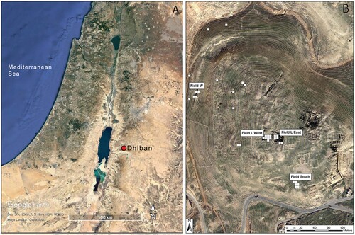
Figure 1. A) The geographic region surrounding the archaeological site of Dhiban, with site location marked. B) The archaeological site of Dhiban. Excavation units (5 × 5 m) are outlined in white, and adjacent labels name each excavation area. The topographic lines are at an interval of 15 m.
The archaeological site of Dhiban consists of a 12.5–15 ha mound, or tall, that is located on a plateau bearing the same name. The plateau is hemmed by two deep escarpments of Cretaceous origin that have water perennially available at their bottoms, known as wadis: the Wadi al-Mujib to the south and the Wadi al-Wala to the north. These wadis were historically recharged by precipitation that falls between the months of November and March, although contemporary dams, reservoirs, and wells have dramatically changed the direction, speed, and intensity of water flow. Precipitation data collected by the Water Authority of Jordan from 1960 until 1990 indicates that the mean annual precipitation of Dhiban is 256.56 mm/yr, with considerable inter-annual variability (El-Naqa Citation1993).
The climate of this area is characterized as mainly hot summer-Mediterranean (Csa) and arid (Bwh), according to the Köppen classification (Peel, Finlayson, and McMahon Citation2007). The plateau and site itself are at the intersection of a Mediterranean and Irano-Turanian bioclimate (Cordova et al. Citation2005, 30), with plant taxa characteristic of Mediterranean, Irano-Turanian, and even Sudanian floristic provinces (Soto-Berelov, Fall, and Falconer Citation2012).
Early excavations were conducted at Dhiban in the 1950s by W. Morton, D. Reed, A.D. Tushingham, and F. Winnett (Winnet and Reed Citation1964; Tushingham Citation1972; Morton Citation1989), while recent excavations have been undertaken by Katherine Adelsberger, Danielle Steen Fatkin, Melissa Kutner, Benjamin Porter, and Bruce Routledge between 2004 and 2023 under the mantle of the Dhiban Excavation and Development Project (DEDP). These excavations have produced evidence that communities have repeatedly resettled the mound for nearly 5000 years, from ca. 3000 b.c. through the present. This is visible in monumental walls, architecture, inorganic objects, and biological remains (Porter et al. Citation2005, Citation2010, Citation2012; Routledge et al. Citation2013).
The site has been divided into four primary areas of excavations referred to as “Fields:” 1) W, 2) L-West, 3) L-East, and 4) S. Field S is located in the southeastern corner of the tall (B). Surface surveys in 2009 and 2010, followed by initial excavations in 2012, led to a preliminary dating of this area to ca. a.d. 500–750 based on diagnostic ceramic evidence. Further excavations within a 10 × 10 m area were then conducted in 2013, 2017, and 2019. All of the data presented in this study derive from Field S.
Phasing and chronology of Field S
A combination of stratigraphy, architecture, radiocarbon dates, and the absence of particular diagnostic pottery points to two broad spans of use of the structures recovered in the 10 × 10 m excavation area of Field S: the period up to and including a catastrophic collapse of these structures (“collapse phase”) and all reuse and reinhabitation that occurred afterward in this same area (the “post-collapse phase”). While the phase of collapse predated the phase of reuse above it, the available radiocarbon evidence, discussed below, suggests that the difference in time between the two phases is likely measurable in decades, if not years, sometime around a.d. 600.
The post-collapse phase begins approximately 25 cm below the surface and comprises what appears to be a reuse and, in certain places, reconstruction of earlier existing architecture. The deposits of this phase are mostly composed of undifferentiated accumulations of sediment (fill), although there were some cooking installations and pits.
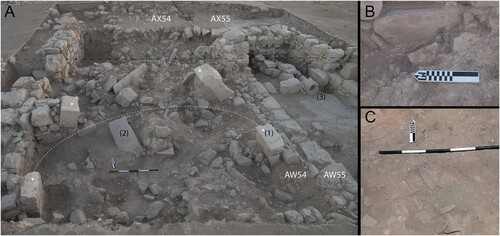
The older collapse phase beneath it consists of at least two identifiable rooms. For ease of readability in this report, these rooms and/or areas, whose architectural limits became clearer by the end of 2013 and were finalized in 2017, are numbered one through four. The westernmost of these rooms (Room 1) was supported by four arch springers (A:1). The deposits found in its center contained large, flat, limestone paving stones more than 1 m in length (A:2) that constituted either an upper floor or a roof. In addition, there were burn marks on the limestone room walls (B), large quantities of charcoal in adjacent deposits, burned small vessels, and numerous reconstructible vessels of various sizes (C). This evidence points to a conflagration and then collapse (or vice-versa) of this room, sealing all of its contents within it, albeit in a fragmentary state.
Figure 2. The collapsed room in Field S in 2013. Unit boundaries have been superimposed on their approximate locations as dashed black lines (photo credit: John E. Webley). The dashed white lines indicate hypothesized arch locations on each set of springers. The numbers indicate 1) arch springers, 2) fallen paving stones, and 3) a drain-like feature. Breakout boxes illustrate B) extensive ash and burning visible on architecture (AX55/AW54) and C) large quantities of pottery, especially storage vessels, recovered from the southern portion of Unit AW54 between A:2 and A:1.
Calibration of 16 AMS 14C dates of short-lived (annual) archaeological plant remains reveals that 10 out of the 16 date to a 2 probability interval of cal a.d. 560–645. It is likely that 12 dates in total date to this range, but larger error ranges from two samples (#13 and 14) do not permit direct chronological comparison in temporal distributions These samples were chosen from deposits at different depths and across all excavation units (A, C).
Figure 3. A) Calibrated radiocarbon probability distributions arranged according to their depth (y-axis) and by excavation unit. B) Bayesian modeled start and end date boundaries for the collapse context (see Supplemental Material 1). C) Spatial locations of calibrated dates within both phases of architecture (post-collapse: gray, collapse: unfilled lines), with rooms or areas highlighted and labeled.
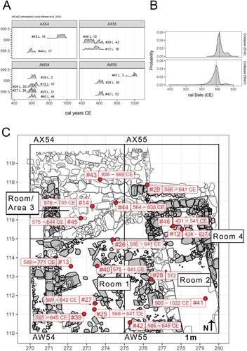
The radiocarbon data indicate that four dates are major temporal outliers. Room 4 (Unit AX55) contained a drain comprised of two rows of stone ca. 30 cm apart ending in a reused basalt mill-stone outlet (A:3). The drain appears to have been blocked not too long after its construction. Two radiocarbon dates from within and adjacent to the drain (#12 and 46) produce the same date range: ca. cal a.d. 430–550, even though they are separated vertically by 50 cm. In addition, the fills of this room consistently contain pale painted pottery; this pale painted ware is not present inside the adjacent and arched larger room (Room 1). The depositional processes that led to the infill of this drain feature must have involved the movement of older organic material. Unfortunately, this does not clarify its function. As a result, the data from Room 4 are presented separately in subsequent tables, as its chronological association with surrounding deposits cannot be verified. Nevertheless, in some spatial visualizations, samples from Room 4 are associated with the phase of major collapse based on the stratigraphic position of samples alone.
The remaining two anomalous dates (#41 and 43) date to the later Abbasid/Fatimid/Crusader periods. They both derive from the uppermost deposits of their respective units (see A), within 10–20 cm of topsoil. They are also located at the furthest northern and southeastern areas of these excavation units, respectively (see C). These late dates are likely due to disturbance of these deposits during or after the time period to which these plant remains date (Porter et al. Citation2007). In contrast, the dates from collapse period deposits in Room 1, three of which were found interspersed among fragmented storage vessels (#25, 26, and 28) and one embedded within a more compact deposit (#27), are all stratigraphically contemporaneous and date to the same exact range, cal a.d. 550–640 (2, ).
Table 1. Uncalibrated and calibrated radiocarbon dates collected from archaeological plant remains in Field S deposits up to the 2017 season. Calibrated dates are based on the IntCal20 curve and were calibrated in R using the rcarbon package. For modeled dates, see Supplemental Material 1.
A Bayesian model of all of the non-outlier radiocarbon dates (Ramsey [Citation2009]; using OxCal 4.4; see Supplemental Material 1 for code) from Room 1 (n = 8) illustrates that the modeled boundaries of the collapse event are centered on a starting date around a.d. 590 and an end date of a.d. 630 (B). This date range serves as the terminus ante quem for the material below it. The two modeled dates from the upper deposits of Room 1, which belong stratigraphically to the post-collapse phases, fall within a 1 range of cal a.d. 600–640 (#13 and 39). They contrast with dates below them that are consistently within a modeled 1
interval of cal a.d. 575–635.
Given this date interval, it is unlikely that the Umayyad conquests of ca. a.d. 640 are the reason for the room’s destruction. Instead, the modeled date of the collapse of the structures in the early 7th century a.d. correlates with archaeological and epigraphic evidence for earthquakes in the region (Rucker and Niemi Citation2010), as well as the destruction of contemporaneous sites (En-Gedi) on the western shore of the Dead Sea. The destruction of these sites near the Dead Sea remains unexplained, however. Researchers have attributed evidence of destruction to attacks by so-called nomads or social and political tension (Hirschfeld Citation2005). In addition, the Sasanian Persian campaign through the Levant in the early 6th century a.d. is a further possibility, considering that Sasanian armies successfully captured Jerusalem in a.d. 614 and held it until a.d. 630 (Foss Citation2003). At present, earthquake damage has not been identified in the Field S structures at Dhiban, nor is there yet any indication of violence (e.g., arrowheads, human skeletons, etc.) in the collapse of these structures.
Even still, Field S is an exceptional context, as the collapse and burning of these rooms, especially Room 1, preserved a snapshot of agricultural production and daily life in the 6th–7th centuries a.d. As a result, its archaeobotanical data illustrates the ways in which the Dhiban community negotiated with larger Byzantine imperial networks in the Late Antique southern Levant during this moment of efflorescence of village life.
Paleoclimate and paleoenvironment
Unlike the archaeological proxies of economic intensification, there is substantial debate regarding climatic conditions in the southern Levant between the 5th and 7th centuries a.d., and systematic reviews of current paleoclimatic evidence are available (e.g., Fuks et al. Citation2017). In brief, palynological (Neumann et al. Citation2007) and limnological (Enzel et al. Citation2003) research conducted at sites near the Dead Sea (and within the Sea itself), alongside analyses of stable inorganic isotopes of O in cave speleothems to the west (Bar-Matthews, Ayalon, and Kaufman Citation1997), have been argued to indicate increased precipitation, runoff flooding, and humidity at this time. The consilience of these climate proxies has led researchers to dub this period as the “Late Antique Little Ice Age” (Büntgen et al. Citation2011, Citation2016), as inferred temperatures reached some of the lowest for this area during the Holocene. Olive and grape pollen have featured prominently in this debate, as they are tied to anthropogenic landscape changes in the form of agriculture, and several pollen cores collected around the Dead Sea note an increase in the frequency of the pollen of both plants, especially from the 4th–7th century a.d. (Neumann et al. Citation2007, Citation2010).
Furthermore, there has been a large amount of archaeological, paleoecological, and paleoclimatic research within the Negev Desert region, as it receives very little precipitation (< 100 mm/yr), and yet archaeobotanical evidence collected from several sites reveals local production of cereals, grape (for wine), and fig up to the mid-6th century a.d. (Ramsay and Tepper Citation2010; Ramsay et al. Citation2016; Ramsay Citation2017). Archaeological evidence of wine presses dating to the 5th and early 6th centuries a.d. likewise indicate major community investment in an agricultural industry that was dependent on a quantity of water that did not exist without irrigation or floodwater runoff capture (Rosen Citation2007). Stable inorganic isotopic evidence (C,
N, and
O) from ovicaprid remains from Shivta and Nessana are argued to show little evidence of a major climatic change in this region, however, as ruminant grazing as well as human herd management strategies persisted both before and after these periods (Vaiglova et al. Citation2020). The archaeobotanical evidence also indicates that the cessation of sustained wine production began up to a century before any major proposed aridification events in the late 6th and early-to-mid 7th century a.d. (Bar-Oz et al. Citation2019). In short, Fuks and colleagues (Citation2020) conclude that “current evidence does not support major long-term climate change in the Negev over the Byzantine–Umayyad period.”
It is therefore likely that temperature and precipitation conditions around Dhiban in the 6th/7th centuries a.d. would have been similar to those encountered today, although with a slightly greater amount of precipitation and less aridity. The Dhiban community still grappled with agricultural production in a semi-arid climate in which rainfall alone could not be entirely relied upon, but one in which water irrigation infrastructure was necessary.
Methodology
Archaeobotanical field sampling
All of the deposits encountered in Field S, as well as the entire archaeological site of Dhiban, were sampled for archaeological plant remains (Farahani Citation2018). A blanket sampling strategy was employed in that every identified context was sampled (d’Alpoim Guedes and Spengler Citation2014). At least one bulk sample was collected from each context. Each bulk sample was one individual collection of sediment from a discrete, physically bounded space. When possible, multiple non-contiguous bulk samples were collected per unique, identifiable archaeological deposit (Lennstrom and Hastorf Citation1992). Archaeological features such as pits and tabuns, if identified as such, were collected in their entirety. These features were sampled at 10 cm intervals, and each subdivision was processed separately. Deposits identified as surfaces were divided into 1 × 1 m grids. No archaeological remains were removed from the sediment matrix during sampling, including faunal remains, ceramic, shell, and other organic and inorganic material. All samples were point-provenienced using a total station. Samples were processed using a mechanized flotation device based on the Siraf model (Williams Citation1973). An additional ca. 50 g of sediment was also collected from each deposit for microbotanical analysis, which has not yet been conducted.
The results of sample collection between 2009 and 2017 yielded 304 samples in Field S (1189.5 L total of sediment, mean = 7 L). Samples collected up to and including the 2017 excavation season are presented below. However, only a subset (n = 9) of the 2017 samples whose coordinate data could be confirmed through independent field records are utilized. The entirety of each dried light fraction sample was passed through a series of US Standard geologic meshes > 2 mm, > 1 mm, and > 0.5 mm in size. All archaeological plant remains were separated, identified, and quantified using a stereo-microscope to the most specific taxonomic level possible, e.g., to species, genus, or family, in each mesh size up to 0.5 mm. In addition, all of the heavy fraction for each of these samples was processed, which is the material that did not float, and which was captured in a 1 mm mesh. The dried heavy fraction was passed through a set of sieves > 25 mm, > 12.5 mm, > 8 mm, > 4 mm, and > 2 mm in size. All of the analyzed results of heavy fraction sorting are incorporated into this study. Identifications of archaeobotanical specimens were based on modern comparative collections in addition to numerous online and physical resources (e.g., Neef et al. Citation2012).
Spatial and statistical analyses
Spatial analysis of the archaeological plant remains utilizes the Getis-Ord statistic, which locates a point or feature within a defined radius and calculates the spatial clustering of high or low attribute values, in this case the density of plant remains (#/L) (Ord and Getis Citation1995). The output is a
statistic based on a distance-weighted version of a z-score across all samples within a reference area (Bivand, Pebesma, and Gomez-Rubio Citation2013; Bivand and Wong Citation2018). Samples with higher
values, i.e., higher z-scores, will tend to share greater density values with nearby samples. A permutation method was chosen, re-simulating the data 499 times, and the search space around each sample was set to 1 m. In order to reduce the probability of committing a Type I error, research shows that for a sample size of 45 or over, a critical value (
) over 3.0175 must be used (Ord and Getis Citation1995). Analyses were conducted in R > v.4.2.0 using the spdep package.
Results
The collapse assemblage constituted 59 individual samples that equaled 353 L of sediment across 25 unique loci (see for a breakdown by room). These samples produced 5890 archaeological plant remains (excluding wood charcoal), of which 1102 were identified as disseminules of agricultural crops (19% of the total) (see Supplemental Material 1). There was a high level of fragmentation, as there were 2224 fragments identifiable to some crop (38% of all remains) and 1580 unidentifiable fragments (27% of all remains). The large number of identifiable and unidentifiable fragments (65% of all remains) is likely due to the destructive processes that led to the collapse and conflagration of the room(s).
Table 2. The count, proportion, and ubiquity of major classes of archaeobotanical remains recovered in Field S by Room/Area.
Within the collapse deposits, the most numerous identified whole plant remains of agricultural origin were free-threshing wheat caryopses (= grains, see ), most likely of bread or macaroni wheat (Triticum aestivum L./durum L.) based on the evidence of the preserved rachis nodes and diagnostic caryopsis morphology. The next most abundant remains were grape pips (Vitis cf. vinifera L.) and pea (Pisum sativum L.) seeds, and then fig (Ficus carica L.) achenes. In addition, barley (Hordeum vulgare) caryposes were identified, both of the (hulled) two (Hordeum vulgare ssp. distichon) and six (Hordeum vulgare ssp. vulgare) row varieties, although barley grains were neither abundant (n = 16) nor ubiquitous (% = 0.32). There were also emmer wheat (Triticum dicoccum) grains interspersed throughout these samples, although their low count and ubiquity (n = 23, %
= 0.15) suggests that they were a trace crop (i.e., likely residually present in fields), rather than a major object of cereal production.
Lentils (Lens culinaris L.) were the most abundant legume, followed by at least two different varieties of vetch interspersed with other crop seeds, including bitter vetch (Vicia ervilia Willd) and broad bean (Vicia faba). Many of the pea remains were found either halved or fragmented and yet still identifiable due to surface morphology and diagnostic features such as the presence of the hilum. The preservation of many whole pea remains allowed for estimation of the number of peas from identifiable fragments based on weight. An ordinary least squares regression model was created based on random resampling with replacement of available pea weights (see Supplemental Material 1). This method estimated an additional 278–338 peas across six loci, and with this estimate, peas would be the numerically most abundant recovered plant remain (451–511 seeds total).
Finally, while grape pips were the second (or third, if the pea estimates are factored in) most abundant whole crop remain type recovered, there were also other elements of the grape plant present, as well. Grape pedicels, the parts of the stem that attach directly to the grape fruit, as well as pressed grape fruit (mesocarp) and skins, some of which contained embedded grape pips, were found in 28% (pedicels) and 16% (mesocarp) of all samples.
Other infrequently occurring crop or potentially consumable plant remains included two whole olive (Olea europaea L.) pits, a Christ’s Thorn Berry seed (Ziziphus spina-christi), and a fennel (Foeniculum vulgare) schizocarp. The latter two derive from the top of a wall separating Rooms 1 and 3 and from within Room 3, respectively, and therefore may have moved downward from the uppermost deposits.
A larder for wheat, peas, and grapes?
Calculation of the Getis-Ord statistic on the densities (#/L) of grape, pea, and wheat remains shows that there are two separate “hot spots”—one statistically significant cluster of samples that contained a dense concentration of wheat grains and pea seeds in the southern half of Room 1 and another cluster of samples that contained grape pips in the southwestern portion of the same room (). These two clusters of samples contained the greatest densities of remains for each of these taxa and were also spatially proximate in three-dimensional coordinate space.
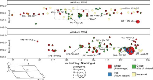
Figure 4. The spatial distribution of the densities of crop remains (grains, seeds, etc. per L) recovered in each flotation sample. Each point represents a bulk flotation sample, and its size is proportional to the density of remains. Color symbolizes the Gi* statistic. Representative photos of specimens of each type of crop remain are located to the right of each plot.
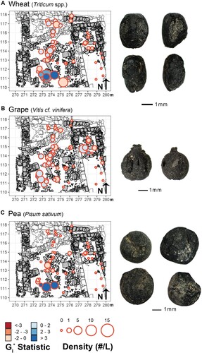
The stratigraphic position of these samples likewise demonstrates that the densest concentrations of wheat and pea were found just below and amid the collapsed limestone paving stones in Room 1 (). Grape remains are predominately found in samples from Room 1 in upper (post-collapse) and lower (collapse) deposits, suggesting that their use (and likely production/harvesting) continued after these rooms collapsed and were re-organized. Peas, in contrast, are virtually absent from almost all of the samples in the upper (post-collapse) deposits. Instead of a termination of production of peas by the Dhiban community after the collapse of these rooms, the presence of pea in the lower collapse deposits, and their absence above, is likely explainable by the exceptional taphonomic circumstances of the conflagration that preserved them nearly in situ in Room 1.
Figure 5. The vertical location of each bulk flotation sample, where the y-axis represents depth (in cm), and the x-axis represents northing and southing values (in m). The figure in the bottom-left indicates the direction of view across excavation units. Point sizes are proportional to the combined density of wheat, pea, and grape remains. Points are colored according to the relative percentage of each taxon they contain. The none category indicates none of the three remains was present. All radiocarbon dates are calibrated to 1.
Moreover, the spatial distributions of the archaeological plant remains and artifacts recovered from the same samples suggest that Room 1 served a purpose akin to a larder in the moments just before its catastrophic collapse: a place where food was kept, handled, and prepared for its final (consumptive) use. While several lines of evidence point to this specific interpretation, until further excavation of this area securely identifies the functional connection of this structure to others at the site, the identification of this space as a larder or a kitchen remains a hypothesis.
First, the values of the densities of ceramic vessel remains (g/L) are the most highly correlated to those of wheat and pea (#/L) in Room 1 (
= 0.81, 95% CI = 0.70–0.88;
: 0.70, 95% CI = 0.54–0.81; A). That is, the densest clusters of samples containing ceramic remains were often the densest clusters of wheat grains and pea seeds. Two adjacent samples in the south of Room 1 have the highest
values for the densities of ceramic and crop remains—this is likely because the wheat grains and pea seeds were stored in at least two or more separate, spatially proximate vessels. Based on the ceramic evidence, both were likely storage jars—neither were amphorae meant for transport (e.g., Magness Citation1993, 227–230). Therefore, these vessels likely held these grains and seeds at the point of transformation into cuisine, as associated samples consisted of more than 94% of crop remains.
Figure 6. A) Density of ceramic remains (g/L) recovered in the heavy fraction of flotation samples. The size of points and color (including the 1 × 1 m grids) indicates the density of remains. B) Images of objects include 1) a basalt quern, 2) an entire juglet recovered in situ, 3) a ceramic cross, 4) an as-yet-unidentified carbonized larva, and 5) and 6) are a reconstructed pouring and cooking vessel, respectively (assembled at UCLA by Francisca Bravo, Cassandra Dadat, and Kaitlyn Ireland under the supervision of Vanessa Muros). The locations of these items are indicated on the map by their associated number.
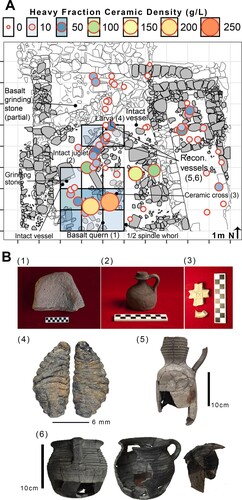
In addition, these dense samples were within 0.5 m of a half-preserved basalt quern and an intact small serving juglet (B:1, 2). Two m to the north, there was a “cooking pot” (cf. Tushingham Citation1972, fig. 9, 6–10), a pouring vessel, large numbers of metal nails, and a large carbonized larva possibly of the Calyptratae, a subsection of the order Diptera that includes house flies (B:4–6).Footnote1 The presence of a large larva in the same deposits as these cooking vessels and grape fruit remains suggests that it was undisturbed for a long enough time to reach a late stage in its growth cycle. Preliminary analysis of the ceramic remains indicate that there were ten pithoi, or very large storage vessels (e.g., Sauer and Herr Citation2012, fig. 3.63.2-4; Tushingham Citation1972, fig. 12, 47–57), in this room, in addition to bowls and plates (e.g., Sauer and Herr Citation2012, figs 3.22.7, 3.71.9, 3.90.3-4), further supporting the interpretation that these vessels were kept in and part of an area of active food storage and processing. Analysis of the faunal remains by Dr. Hannah Lau mirrors the spatial distribution of crop density, in that the deposits within Room 1 contain the greatest concentration of fish (icthyofaunal) remains, as well as those of domesticated animals such as sheep, goat, chicken, and pig. Therefore, both plants and animals likely destined for consumption were handled in the same area.
Wine at Late Antique Dhiban?
Margaritis and Jones (Citation2006) have argued that the presence of different parts of the domesticated grape plant—pips, pedicels, and fruits—found within ceramic vessels may indicate wine storage or its presence. By comparing ethnoarchaeological research on wine-making techniques in contemporary rural Greece with the results of the experimental charring of grape mesocarps and pips, Margaritis and Jones argued that if all of these remains are found together in association with whole or fragmented pithoi, “they can represent wine dregs of any kind of wine stored in the vessel” (Margaritis and Jones Citation2006, 798). The authors indicate that remains found in this state might indicate white wine specifically (Margaritis and Jones Citation2006, 799). In fact, Flavius Cresconius Corripus, a poet of the 6th century a.d., praised the wine of Byzantine Palestine for its “very fair snow white color” (alba colore nivis blandoque levissima, In Laudem Iustini Augusti Minoris 3.85–97).
It is likely that some of the samples from Room 1 derive from the remains (dregs) of wine. Specifically, the deposits in the southwest of Room 1 contained 1) the most grape pips, 2) pressed grape mesocarps with seeds still embedded, and 3) very long pedicels (). The deposit directly underneath these samples contained a dense concentration of ceramic remains (59 g/L, symbolized in light green in the 1 × 1 m grid of A), among which preliminary analysis has identified jars.
Figure 7. The distribution of all grape remains recovered in flotation samples from the collapse deposits, in which point size is proportional to the total density of grape pips, pedicels, and pressed skins. The interior colors represent the relative percentage of each recovered item, and images of representative archaeological remains are located beneath the legend.
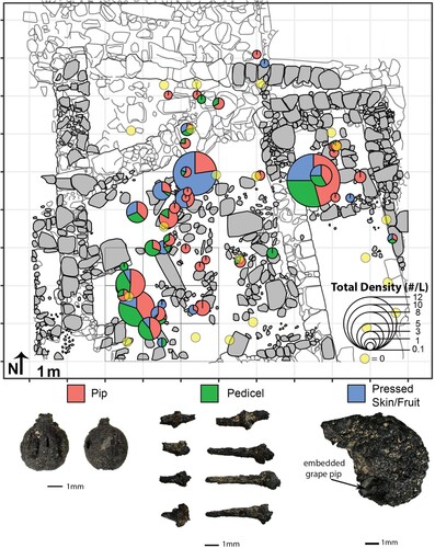
It is possible, however, that these grape remains represent raisins or whole grapes, since it is not always possible to morphologically distinguish archaeological raisins, grapes, and the dregs of wine. For example, at Bronze Age Tell es-Sa‘idiyeh in the Jordan Valley, researchers argued that carbonized grape remains preserved in a similar larder context were whole grapes, and not raisins, based on SEM analyses of surface morphology (Cartwright Citation2003). Similarly, Margaritis and Jones (Citation2006, 800) remark that raisins and whole grapes are identified in archaeological contexts as “embedded whole fruits, occasionally with attached or loose pedicles.”
While this description fits a dense concentration of grape pips and fruit fragments found in the north of Room 1, where they are found alongside cooking and serving vessels (), no whole grapes were found, despite the excellent conditions of preservation. In contrast, the samples in the southwest of Room 1 do not contain a high density of pips, contain long pedicels, and are also more correlated with ceramic remains. It is therefore more likely that the remains in the north of Room 1 (i.e., those found in the same area as the larva and the cooking pots) are grapes (or raisins) meant for consumption, while those from the southwestern corner of the room could represent wine. Further analysis of the ceramic vessels from these contexts will help distinguish between these possibilities.
Specialization and localization in Late Antique Dhiban and the greater Dead Sea communities
At a much larger scale, the presence of wheat, peas, and grape in association with ceramic vessels used for storage, cooking, and serving all point to a broader agricultural strategy focused on the production of these crops. The near-contemporaneous Nessana and Petra papyri provide supporting evidence that wheat and grape were grown broadly in the region at this time. These papyri are a unique source of information, as they highlight the minutiae of agricultural life recorded by members of the communities of Nessana (in the Negev) and Petra (near Wadi Musa), both approximately 150 km to the south of Dhiban. Nessana Papyrus 82, for example, explicitly mentions the triple-cropping of wheat-legume-grape, describing how wheat (sitos) and a legume (arakos) were alternated in adjacent plots (Kraemer Citation2015).
Moreover, Nessana Papyrus 39, dated to the mid-6th century a.d., lists several nearby cities (poleis) of the Negev west of the Dead Sea from whom taxes are collected by imperial authorities in fractions and “carats,” or fractions, of solidii, which were gold coins used in this period as a tradeable item with a semi-stable value fixed to their level of fineness and weight (Morrison and Sodini Citation2002, 218; Kraemer Citation2015, 120–121; ). While these are taxes “in coin,” illustrating the importance of the Byzantine imperial monetary economy in the southern Levant (Walmsley Citation1999), Nessana Papyrus 40, dated to the early 7th century a.d., indicates that wheat could often be used as a form of salary (tropheia) for work performed. Nessana Papyrus 80 also records that wheat alone was used as a donative to the local church. Wheat served not only a functional role as food for the Late Antique communities of the southern Levant but could also be used as salary, a donative, and a taxed commodity.
Therefore, how and why the communities around the Dead Sea and broader southern Levant chose to engage in specific schemes of agricultural production appears to be a product of imperial demand and local specialization. The triple-cropping strategy identified in the archaeological plant remains recovered at Dhiban and recorded in papyri from the Negev may indicate that there were regional knowledge networks about agricultural production among the Dead Sea Late Antique communities that were specifically oriented to the environmental challenges of plant growth in a semi-arid landscape but also respondent to the social realities of taxation and payments of salary.
There are two key indicators of this specialization. The first is olive, which is rare among the analyzed samples in the collapse deposits of Field S at Dhiban. Only two samples yielded an entire Olea pit, while fragments were interspersed in very low densities (< 0.05 g in four samples). The rarity of olive at Dhiban suggests that olive was not grown in the vicinity of the site, was present as processed oil alone, or that the fruits of this crop are to be found in other areas of the site. Another possibility is seasonality: as olive trees were typically harvested in the ancient Mediterranean between November and December (Foxhall Citation2007, 6–9), the contents of this kitchen might represent the harvest of wheat and pea only, which often occurs between the months of April and June (Palmer Citation1998, 150).
Still, the presence of olive remains at other contemporaneous sites in the region that report archaeobotanical data illustrate the unique situation of this specific context at Dhiban. Olive is present in 41% of samples at Hisban, 20% of the samples from Khirbet Faris, 20% of the samples at Pella, and it constitutes 34% of the identified domesticated remains (not samples) from a pool and garden context at Petra (, ). Moreover, olive pits have been recovered at sites in the arid Negev, such as Elusa (Bar-Oz et al. Citation2019), and an olive press at Shivta suggests larger scale oil production there (Fuks et al. Citation2016). Given that the unique taphonomic circumstances of the collapse context in Field S at Dhiban seem to have preserved most of the archaeological plant remains, if olive were consumed or stored whole, there is little evidence of it in this area, which is all the more surprising considering the remains of cooking and food preparation activities in this space.
Figure 8. The ubiquity, or proportional presence across samples, of selected crop remains from sites near Dhiban that date approximately between a.d. 500 and 700 where such data are available. The number of analyzed samples is located with each plot.
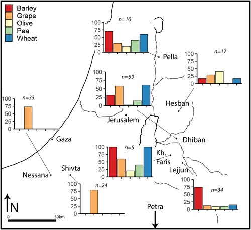
Table 3. Contemporaneous sites in the southern Levant ca. 6th/7th century a.d. that have reported relevant archaeobotanical data. A ‘+’ indicates the presence of that archaeobotanical remain category. Sites are arranged according to their direct linear distance in kilometers from Dhiban.
In contrast, the collapse contexts of the Field S structures at Dhiban have one of the highest ubiquities of grape pips (58% of samples) of any contemporaneous site, apart from the wine producing centers of Nessana and Shivta. It could be argued that differences in crop frequencies between settlements are due to the archaeological contexts that have been excavated. For instance, thus far at Dhiban, only one Byzantine/Late Antique period structure-complex (Field S) has been sampled for archaeobotanical and faunal remains. Nevertheless, differences in excavation contexts alone cannot account for the presence and absence of major crops across these sites. Despite the greater amount of sediment processed in Field S at Dhiban, neither dates (Phoenix dactylifera) nor peach pits (Prunus persica) have been found, and yet they are present at nearby Lejjun and Khirbet Faris, despite the smaller number of analyzed samples.
Instead, the greater relative frequency of some crops, such as wheat and grape at Dhiban, barley at Lejjun, and olive at Hisban, appear connected to the interdependence of the (tax) desires of imperial elites and trade between and among these communities based on their specific local environmental opportunities and challenges. Here, “elite” refers to imperial agents such as the governors of provinces and on-the-ground local functionaries drawn from a mixed Greek and Arabic (and to a lesser degree, Aramaic) speaking population (as seen in the names of the sons of Eulais in Nessana Papyrus 31, including one Victor and Khalaf Allah). While certain plants, such as wheat, were an important domesticate for millennia in this region, the Nessana papyri nonetheless illustrate how they gained considerable legal, economic, and political potency under the Byzantine imperial state in the Late Antique period.
To this end, Eusebius, in his Onomasticon, noted that Dhiban was a very large village stationed in a remote area (epi tēs erēmiou) in the 4th century a.d. Even in the early 8th century a.d., church mosaics, including at Umm al-Rasas, 8 km southeast of Dhiban, do not include it among the registers of important cities (poleis) in the Late Antique period (Bowersock Citation2006). Rather, Dhiban was most likely a village, or a komē. As Kraemer (Citation2015, 123) argues from the evidence of the Nessana papyri, one group under taxation in these villages () were the suntelstai, or “the association of citizens responsible for seeing that tax quotas were met,” whether in coin or in wheat valued by weight. The organization of these tax efforts seems to have had little direct state intervention, as inscriptions in the Negev cite officials known as vicarii, who were “prominent on the local level but did not hold high-ranking positions in the imperial administration” (Rubin Citation1996, 62).
A komē like Dhiban would have likely paid taxes as wheat organized by their own local suntelstai. Apart from the very-dense samples of wheat from Room 1 that were likely from specific, destroyed storage vessels, wheat is the most ubiquitous crop remain across the collapse context of Field S, attesting to its importance. Indeed, comparison of the archaeobotanical data from Field S to later periods of inhabitation at the same site illustrates the temporal specificity of the importance of specific crops. During the Middle Islamic II period (ca. a.d. 1260–1450), when Dhiban was part of the Mamluk empire, archaeobotanical data show a much lower ubiquity of grape and a greater abundance of barley, in near parity with wheat, likely due to a shifted emphasis on sheep-goat husbandry (Farahani Citation2018).
More contemporary sites reveal a similar trend. At al-Lejjun, a contemporary military barracks 20 km to the southeast of Dhiban, nearly 75% of the analyzed samples contain barley, interpreted as likely animal fodder. Wheat caryposes were not abundant, but a higher ubiquity of wheat rachises suggests that the stationed soldiers and affiliated villagers were also harvesting it. As Crawford (Citation2006, 459) notes, however, “it is not clear … whether all of these items were produced locally.” One possibility is that a komē such as Dhiban, with clear evidence of sustained wheat production, was one such exporter of wheat to nearby communities.
The abundance of grape pips (seeds), pedicels, and exo/mesocarps (skins/fruits) in Field S at Dhiban likewise suggest that the community produced these crops for more than intra-community consumption. Regional and long-distance exchange in wine and grape in the Late Antique southern Levant is well documented through the circulation of specific types of amphorae and serving vessels (Kingsley Citation2001; da Costa Citation2007) and is depicted in mosaics from the region: one from Kissufim, now in Israel, shows a named individual (Orbikon) leading a camel that bears likely wine-holding amphorae, as the driver conspicuously holds a bunch of grapes in his right hand (Fuks et al. Citation2020). This trade was supported by networks of caravanserai across the region used by travelers, merchants, and religious pilgrims (Kingsley and Decker Citation2001).
Wine, apart from its ritual significance in church rites, was also a major object of ecclesiastic production for trade and exchange (Mayerson Citation1985). The structure complex containing Room 1 in Field S at Dhiban is 80 m to the west and north of a contemporaneous church documented by Tushingham and colleagues in the 1950s a.d. (Tushingham Citation1972, 63–68). The excavators dated the structure to the late 6th century a.d. based on a Justinian coin found underneath the church pavement, indicating that it could be dated “no earlier” than his reign. While no wine presses have been found at Dhiban, a small 6 × 6 cm ceramic cross found in Room 1 (B:3) suggests that agricultural productive efforts related to grape could have contributed to larger ecclesiastic functions relating to food or at least may have been traded across inter-community exchange networks. Again, inscriptional and architectural evidence shows that there was a dense concentration of churches in settlements around Dhiban, such as at Hisban, Umm al-Rasas, and Mount Nebo (Di Segni Citation1999), which were vital conduits in pilgrimage and ecclesiastic-economic networks.
Finally, further morphometric research will determine to what extent these grapes were of domesticated or wild varieties. Morphometric research has shown that morphological differentiation between wild and domesticated archaeological grape remains by shape is possible using statistical techniques such as elliptical Fourier analysis (Terral et al. Citation2010; Bouby et al. Citation2013). An archaeobotanical analysis of a Roman-period wine press in Portugal using such methods found that nearly 60% of archaeological grape seeds were likely of wild origin, suggesting that wine was made even with wild grapes (Coradeschi et al. Citation2023). Therefore, it is possible that some of the grape pips recovered at Field S are of wild origin but were nonetheless harvested for processing, consumption, and trade.
Conclusion
Paleoethnobotanical evidence illustrates that the inhabitants of Dhiban were fully integrated into regional agricultural networks and adapted to the local socio-economic realities of the 6th and 7th centuries a.d. through the production of specific crops and not others. The recovery of grapes, wheat, and peas, but not olive or date, provides a unique window into how the Dhiban community negotiated its role within the larger Byzantine empire: through the production of agricultural goods, such as wheat, of great value to imperial political functionaries, through possible participation in exchange networks with grapes, but also through attention to local environmental conditions by growing nitrogen-fixing peas. What the differential distribution of these crops between contemporaneous sites illustrates are the ways in which plants played a key role in the relationships of southern Levantine communities of Late Antiquity to each other, to the Byzantine imperial state, and to their local environment. To what extent these agricultural practices correlate with climatically favorable conditions for agriculture, especially after the mid-6th century a.d., remains debated (Neumann et al. Citation2010; Rambeau Citation2010; Izdebski et al. Citation2016; Fuks et al. Citation2017).
Papyrological evidence from the Negev and archaeological evidence from Dhiban suggest that the Byzantine state did not directly intervene into the lifeways of the local community but instead facilitated the conditions for emergent communities of agricultural practice and specialization in the southern Levant through the mechanisms of taxation, supply of food to the army, and religious sponsorship. The kitchen context of Field S at Dhiban is therefore a microcosm of this broader economic and environmental world—the crops found within it exist only because they were embedded in larger socio-economic practices and productive strategies. The archaeobotanical data recovered at Dhiban suggest that its community participated in these socio-economic networks in intentional ways—not necessarily because of any deliberate imperial mandate but in response to local opportunities while grappling with a less predictable water supply. The Dhiban community, therefore, was far from a passive reactant, as it seems to have actively negotiated its place within a broader mosaic of cities and villages.
Finally, while time and labor intensive, the point-provenience of each of these individual archaeobotanical samples is a key driver of insight into the spatial association of plants, artifacts, and architecture used to answer the question of non-local imperial invention that would have been lost with less granular methods. Presentation of these data as an entire time period dis-embedded from its spatial context would miss the ways in which these plants were heterogeneously distributed across the site. Much more information is revealed concerning the daily, lived practices of the community, including how they stored food, where, and in what ways. Use of these methods therefore improves the ability of archaeologists to identify changes in lifeways locally and regionally in moments of imperial socio-political reconfiguration. Paleoethnobotany can provide data when epigraphic, historical, or other forms of available written language evidence might be scarce or otherwise absent.
Supplemental Material
Download Comma-Separated Values File (4.3 KB)Supplemental Material
Download Comma-Separated Values File (435.4 KB)Supplemental Material
Download Comma-Separated Values File (34.3 KB)Supplemental Material
Download Comma-Separated Values File (1.8 KB)Supplemental Material
Download MS Word (1.3 MB)Acknowledgements
An earlier iteration of this research appears in a 2014 UC Berkeley dissertation by the first author (Farahani 2014). The first author thanks the following former research assistants from the University of California, Berkeley—Paquita Esterly, Loren Murch, and Daniela Ruiz—and the UCLA Cotsen Institute of Archaeology—Francisca Bravo, Amy Chan, Cassandra Dadat, Michele Gorrie, Maya Gutierrez, Kaitlyn Ireland, Lauren Lien, Kyle Montgomery, Sergio Roman, Paulo Suarez, and Brian Vallejo—for their invaluable help in the laboratory analysis of the heavy fraction of flotation. This material was excavated by, and the authors are indebted to, Christopher Bravo, Elizabeth Dolinar, Faye Johnson, Emily Booker, Rudi Vanzin, Martin Weber, and Deland Wing, as well as DEDP team members Andrew Wilson, Bruce Routledge, and Katherine Adelsberger. The authors thank the director and staff of the Jordanian Department of Antiquities for their support during the excavation of this evidence. Finally, thanks to Hannah Lau and two anonymous reviewers for their very helpful suggestions that improved this manuscript.
Disclosure Statement
No potential conflict of interest was reported by the authors.
Additional information
Funding
Notes on contributors
Alan Farahani
Alan Farahani (Ph.D. 2014, UC Berkeley) is the founder of SciScope Solutions, a consulting group that develops database, analytic, and visualization tools for laboratory and field scientists. He is also graduate faculty at the University of Nevada, Las Vegas (USA) in the Department of Anthropology.
Melissa Kutner
Melissa Kutner (Ph.D. 2012, Stanford University) is an Assistant Professor at the University of Maryland, Baltimore County (USA) in the Department of Ancient Studies.
Danielle Steen Fatkin
Danielle Steen Fatkin (Ph.D. 2007, Stanford University) is the associate Dean for Faculty Affairs and Associate Professor of History at Knox College (IL, USA), where she is also the Chair of Archaeology.
Benjamin W. Porter
Benjamin W. Porter (Ph.D. 2007, University of Pennsylvania) is an Associate Professor of Middle Eastern Archaeology in the Department of Middle Eastern Languages & Cultures at the University of California, Berkeley (USA).
Notes
1 Preliminary identification by Dr. Martin Hauser, Senior Insect Biosystematist, California Department of Food and Agriculture.
References
- Ashkenazi, J., and M. Aviam. 2017. “Monasteries and Villages: Rural Economy and Religious Interdependency in Late Antique Palestine.” Vigiliae Christianae 71: 117–133.
- Bar, D. 2004. “Population, Settlement and Economy in Late Roman and Byzantine Palestine (70 - 641 AD).” Bulletin of the School of Oriental and African Studies 67: 307–320.
- Bar-Matthews, M., A. Ayalon, and A. Kaufman. 1997. “Late Quaternary Paleoclimate in the Eastern Mediterranean Region from Stable Isotope Analysis of Speleothems at Soreq Cave, Israel.” Quaternary Research 47: 155–168.
- Bar-Oz, G., L. Weissbrod, T. Erickson-Gini, Y. Tepper, D. Malkinson, M. Benzaquen, D. Langgut, Z.C. Dunseth, D.H. Butler R. Shahack-Gross, and J. Roskin. 2019. “Ancient Trash Mounds Unravel Urban Collapse a Century Before the End of Byzantine Hegemony in the Southern Levant.” Proceedings of the National Academy of Sciences 116: 8239–8248.
- Bivand, R. S., E. Pebesma, and V. Gomez-Rubio. 2013. Applied Spatial Data Analysis with R. 2nd ed. New York: Springer.
- Bivand, R. S., and D. W. Wong. 2018. “Comparing Implementations of Global and Local Indicators of Spatial Association.” TEST 27: 716–748.
- Bouby, L., I. Figueiral, A. Bouchette, N. Rovira, S. Ivorra, T. Lacombe, T. Pastor, S. Picq, P. Marinval, and J.-F. Terral. 2013. “Bioarchaeological Insights Into the Process of Domestication of Grapevine (Vitis Vinifera L.) During Roman Times in Southern France.” PLoS One 8: e63195.
- Bowersock, G. W. 2006. Mosaics as History: The Near East from Late Antiquity to Islam. Cambridge: Harvard University Press.
- Brown, P. 2012. Through the Eye of a Needle: Wealth, the Fall of Rome, and the Making of Christianity in the West, 350-550 AD. Princeton: Princeton University Press.
- Büntgen, U., V. S. Myglan, F. C. Ljungqvist, M. McCormick, N. Di Cosmo, M. Sigl, J. Jungclaus, S. Wagner, P. J. Krusic, J. Esper, and J. O. Kaplan. 2016. “Cooling and Societal Change During the Late Antique Little Ice Age from 536 to Around 660 AD.” Nature Geoscience 9: 231–236.
- Büntgen, U., W. Tegel, K. Nicolussi, M. McCormick, D. Frank, V. Trouet, J. O. Kaplan, F. Herzig, K. U. Heussner, H. Wanner, and J. Luterbacher. 2011. “2500 Years of European Climate Variability and Human Susceptibility.” Science 331: 578–582.
- Cartwright, C. R. 2003. “Grapes or Raisins? An Early Bronze Age Larder Under the Microscope.” Antiquity 77: 345–348.
- Chavarria, A., and T. Lewit. 2004. “Archaeological Research on the Late Antique Countryside: A Bibliographic Essay.” In Late Antique Archaeology Vol II: Recent Research on the Late Antique Countryside, edited by W. Bowden, L. Lavan, and C. Machado, 2: 3–51. Leiden.
- Coradeschi, G., M. Ucchesu, E. Dias, J. Cunha, M. M. Baleiras-Couto, M. Ângelo, C. A. Ribeiro, C. B. Dias, and G. Bacchetta. 2023. “A Glimpse Into the Viticulture of Roman Lusitania: Morphometric Analysis of Charred Grape Pips from Torre Dos Namorados, Portugal.” Vegetation History and Archaeobotany 32: 349–360.
- Cordova, C. E., C. Foley, A. Nowell, and M. Bisson. 2005. “Landforms, Sediments, Soil Development, and Prehistoric Site Settings on the Madaba-Dhiban Plateau, Jordan.” Geoarchaeology: An International Journal 20: 29–56.
- Crawford, P. 2006. “The Plant Remains.” In The Roman Frontier in Central Jordan: Final Report on the Limes Arabicus Project, edited by S. T. Parker, 453–461. Washington D.C: Dumbarton Oaks.
- da Costa, K. 2007. “The Limits of Long-Distance Exchange: Evidence from Sixth-Century Palaestina/Arabia.” In Incipient Globalization? Long-Distance Contacts in the Sixth Century, edited by A. Harris, 35–46. Oxford: British Archaeological Reports.
- d’Alpoim Guedes, J., and R. Spengler. 2014. “Sampling Strategies in Paleoethnobotanical Analysis.” In Method and Theory in Paleoethnobotany, edited by J. M. Marston, J. d’Alpoim Guedes, and C. Warinner, 77–94. Boulder: University Press of Colorado.
- D’Altroy, T. N., and C. A. Hastorf. 2002. “The Domestic Economy, Households, and Imperial Transformation.” In Empire and Domestic Economy, edited by T. N. D’Altroy, and C. A. Hastorf, 3–25. New York: Kluwer Academic Publishers.
- Decker, M. 2009. Tilling the Hateful Earth: Agricultural Production and Trade in the Late Antique East. Oxford: Oxford University Press.
- Di Segni, L. 1999. “Epigraphic Documentation on Building in the Provinces of Palaestina and Arabia, 4th-7th CE.” In The Roman and Byzantine Near East, 2: Some Recent Archaeological Research, edited by J. H. Humphrey, 149–178. Journal of Roman Archaeology.
- El-Naqa, A. 1993. “Hydrological and Hydrogeological Characteristics of Wadi El-Mujib Catchment Area, Jordan.” Environmental Geology 22: 257–271.
- Enzel, Y., R. Bookman, D. Sharon, H. Gvirtzman, U. Dayan, B. Ziv, and M. Stein. 2003. “Late Holocene Climates of the Near East Deduced from Dead Sea Level Variations and Modern Regional Winter Rainfall.” Quaternary Research 60: 263–273.
- Farahani, A. 2018. “A 2500-Year Historical Ecology of Agricultural Production Under Empire in Dhiban, Jordan.” Journal of Anthropological Archaeology 52: 137–155.
- Fiema, Z. T. 2007. “The Byzantine Military in the Petra Papyri.” In The Late Roman Army in the Near East from Diocletian to the Arab Conquest, edited by A. S. Lewin, and P. Pellegrini, 313–319. Oxford: Archaeopress.
- Forste, K. M. 2021. “An Intrasite Analysis of Agricultural Economy at Early Islamic Caesarea Maritima, Israel.” Ethnobiology Letters 12: 58–69.
- Foss, C. 2003. “The Persians in the Roman Near East (602 AD).” Journal of the Royal Asiatic Society 13: 149–170.
- Foxhall, L. 2007. Olive Cultivation in Ancient Greece: Seeking the Ancient Economy. Oxford: Oxford University Press.
- Frankel, R. 1997. “Presses for Oil and Wine in the Southern Levant in the Byzantine Period.” Dumbarton Oaks Papers 51: 73–84.
- Fuks, D., O. Ackermann, A. Ayalon, M. Bar-Matthews, G. Bar-Oz, Y. Levi, A. Maeir, E. Weiss, T. Zilberman, and Z. Safrai. 2017. “Dust Clouds, Climate Change and Coins: Consiliences of Palaeoclimate and Economy in the Late Antique Southern Levant.” Levant 49: 205–223.
- Fuks, D., G. Bar-Oz, Y. Tepper, T. Erickson-Gini, D. Langgut, L. Weissbrod, and E. Weiss. 2020. “The Rise and Fall of Viticulture in the Late Antique Negev Highlands Reconstructed from Archaeobotanical and Ceramic Data.” Proceedings of the National Academy of Sciences 117: 19780–19791.
- Fuks, D., E. Weiss, Y. Tepper, and G. Bar-Oz. 2016. “Seeds of Collapse? Reconstructing the Ancient Agricultural Economy at Shivta in the Negev.” Antiquity 90 (353, e5): 1–5.
- Fuller, D. Q., and C. J. Stevens. 2009. “Agriculture and the Development of Complex Societies: An Archaeobotanical Agenda.” In From Foragers to Farmers: Papers in Honour of Gordon C. Hillman, edited by A. Fairbairn, and E. Weiss, 37–57. Oxford: Oxbow Books.
- Garrido, F. 2016. “Rethinking Imperial Infrastructure: A Bottom-up Perspective on the Inca Road.” Journal of Anthropological Archaeology 43: 94–109.
- Gilliland, D. 1986. “Paleoethnobotany and Paleoenvironment.” In Environmental Foundations: Studies of Climatical, Geological, Hydrological, and Phytological Conditions in Hesban and Vicinity, edited by Ø LaBianca, and L. Lacelle, 123–142. Berrien Springs, MI: Andrews University Press.
- Glatz, C. 2009. “Empire as Network: Spheres of Material Interaction in Late Bronze Age Anatolia.” Journal of Anthropological Archaeology 28 (2): 127–141.
- Hastorf, C. A. 1990. “The Effect of the Inka State on Sausa Agricultural Production and Crop Consumption.” American Antiquity 55: 262–290.
- Hastorf, C. A. 2009. “Agriculture as Metaphor of the Andean State.” In Polities and Power: Archaeological Perspectives on the Landscapes of Early State, edited by S. E. Falconer, and C. Redman, 52–72. Tuscon: University of Arizona Press.
- Hirschfeld, Y. 1997. “Farms and Villages in Byzantine Palestine.” Dumbarton Oaks Papers 51: 31–71.
- Hirschfeld, Y. 2005. “En-Gedi: ‘A Very Large Village of Jews’.” Liber Annuus 55: 327–354.
- Hoppé, C. 1999. “A Thousand Years of Farming: Agricultural Practices from the Byzantine to Early Ottoman Period at Khirbet Faris, the Kerak Plateau, Jordan.” PhD thesis, Sheffield: University of Sheffield.
- Izdebski, A., J. Pickett, N. Roberts, and T. Waliszewski. 2016. “The Environmental, Archaeological and Historical Evidence for Regional Climatic Changes and Their Societal Impacts in the Eastern Mediterranean in Late Antiquity.” Quaternary Science Reviews 136: 189–208.
- Kennedy, D. L. 2004. The Roman Army in Jordan. London: Council for British Research in the Levant.
- Kingsley, S. 2001. “The Economic Impact of the Palestinian Wine Trade in Late Antiquity.” In Economy and Exchange in the East Mediterranean During Late Antiquity, edited by M. Decker, and S. Kingsley, 44–68. Oxford: Oxbow Books.
- Kingsley, S., and M. Decker. 2001. “New Rome, New Theories on Inter-Regional Exchange. An Introduction to the East Mediterranean Economy in Late Antiquity.” In Economy and Exchange in the East Mediterranean During Late Antiquity, edited by M. Decker, and S. Kingsley, 1–27. Oxford: Oxbow Books.
- Kraemer Jr, C. J. 2015. Excavations at Nessana, Volume 3: Non-Literary Papyri. Princeton: Princeton University Press.
- Laiou, A. E., and C. Morrisson. 2007. The Byzantine Economy. Cambridge: Cambridge University Press.
- Lennstrom, H. A., and C. A. Hastorf. 1992. “Testing Old Wives’ Tales in Palaeoethnobotany: A Comparison of Bulk and Scatter Sampling Schemes from Pancán, Peru.” Journal of Archaeological Science 19 (2): 205–229.
- Lightfoot, K. G., and A. Martinez. 1995. “Frontiers and Boundaries in Archaeological Perspective.” Annual Review of Anthropology 24: 471–492.
- Magness, J. 1993. Jerusalem Ceramic Chronology Circa 200-800 CE. Sheffield: Sheffield Academic Press.
- Margaritis, E., and M. Jones. 2006. “Beyond Cereals: Crop Processing and Vitis Vinifera L. Ethnography, Experiment and Charred Grape Remains from Hellenistic Greece.” Journal of Archaeological Science 33: 784–805.
- Mayerson, P. 1985. “The Wine and Vineyards of Gaza in the Byzantine Period.” Bulletin of the American Schools of Oriental Research 257: 75–80.
- Morrison, C., and J.-P. Sodini. 2002. “The Sixth-Century Economy.” In The Economic History of Byzantium: From the Seventh Through the Fifteenth Century, edited by A. E. Laiou, 171–218. Washington D.C: Dumbarton Oaks.
- Morton, W. H. 1989. “The 1954, 55, and 65 Excavations at Dhiban in Jordan.” In Studies in the Mesha Inscription and Moab, edited by A. Dearman, 239–246. Atlanta: Scholars Press.
- Neef, R., R. T. Cappers, R. M. Bekker, and L. Boulos. 2012. Digital Atlas of Economic Plants in Archaeology. Barkhuis: Amsterdam.
- Neumann, F. H., E. J. Kagan, S. A. Leroy, and U. Baruch. 2010. “Vegetation History and Climate Fluctuations on a Transect Along the Dead Sea West Shore and Their Impact on Past Societies Over the Last 3500 Years.” Journal of Arid Environments 74: 756–764.
- Neumann, F. H., E. J. Kagan, M. J. Schwab, and M. Stein. 2007. “Palynology, Sedimentology and Palaeoecology of the Late Holocene Dead Sea.” Quaternary Science Reviews 26 (11): 1476–1498.
- Ord, J. K., and A. Getis. 1995. “Local Spatial Autocorrelation Statistics: Distributional Issues and an Application.” Geographical Analysis 27: 286–306.
- Palmer, C. 1998. “Following the Plough”: The Agricultural Environment of Northern Jordan.” Levant 30: 129–165.
- Parker, S. T. 1987. The Roman Frontier in Central Jordan: Interim Report. Oxford, UK: British Archaeological Reports.
- Parker, A. J. 1992. “Cargoes, Containers and Stowage: The Ancient Mediterranean.” International Journal of Nautical Archaeology 21: 89–100.
- Parker, S. T. 2006. The Roman Frontier in Central Jordan: Final Report. Washington, D.C.: Dumbarton Oaks.
- Peel, M. C., B. L. Finlayson, and T. A. McMahon. 2007. “Updated World Map of the Köppen-Geiger Climate Classification.” Hydrol. Earth Syst. Sci. 11: 1633–1644.
- Perry, M., M. Y. el-Najjar, M. Finnegan, D. S. Reese, and J. Ramsay. 2013. “Human, Animal, and Plant Remains.” In Humayma Excavation Project, 2: Nabataean Campground and Necropolis, Byzantine Churches, and Early Islamic Domestic Structures, edited by J. P. Oleson, and R. Schick, 321–379. Boston, MA: American Schools of Oriental Research.
- Pető, Á, Á Kenéz, A. C. Prunner, and Z. Lisztes-Szabó. 2015. “Activity Area Analysis of a Roman Period Semi-Subterranean Building by Means of Integrated Archaeobotanical and Geoarchaeological Data.” Vegetation History and Archaeobotany 24: 101–120.
- Pieri, D. 2012. “Regional and Interregional Exchanges in the Eastern Mediterranean During the Early Byzantine Period: The Evidence of Amphorae.” In Trade and Markets in Byzantium, edited by C. Morrisson, 27–50. Washington, D.C.: Dumbarton Oaks Papers.
- Porter, B. W., B. Routledge, D. Fatkin, K. Adelsberger, A. Farahani, A. Wilson, and W. Schultz. 2012. “The Dhiban Excavation and Development Project’s 2009 Season: Field L Excavations.” Annual of the Department of Antiquities of Jordan, 111–129.
- Porter, B. W., B. Routledge, D. Fatkin, W. Zimmerle, J. Hakes, J. Salvant, and W. Schultz. 2010. “The Dhiban Excavation and Development Project’s 2005 Season.” Annual of the Department of Antiquities of Jordan 54: 9–34.
- Porter, B. W., B. Routledge, D. Steen, and F. al-Kawamlha. 2007. “The Power of Place: The Dhiban Community Through the Ages.” In Crossing Jordan: North American Contributions to the Archaeology of Jordan, edited by T. E. Levy, M. P. M. Daviau, R. W. Younker, and M. Shaer, 315–322. London: Equinox Publishing.
- Porter, B. W., B. Routledge, D. Steen, C. Parlsow, L. de Jong, and W. Zimmerle. 2005. “Tall Dhiban 2004 Pilot Season: Prospection, Preservation, and Planning.” Annual of the Department of Antiquities of Jordan 49: 201–216.
- Rambeau, C. M. C. 2010. “Palaeoenvironmental Reconstruction in the Southern Levant: Synthesis, Challenges, Recent Developments and Perspectives.” Philosophical Transactions of the Royal Society A: Mathematical, Physical and Engineering Sciences 368: 5225–5248.
- Ramsay, J. 2017. “Human Population Increase and Its Effects on the Arid Landscape of Southern Jordan: An Archaeobotanical Study.” In The Socio-Economic History and Material Culture of the Roman and Byzantine Near East: Essays in Honor of S. Thomas Parker, edited by W. D. Ward, 349–383. Piscataway, NJ: Gorgias Press.
- Ramsay, J., and L.-A. Bedal. 2015. “Garden Variety Seeds? Botanical Remains from the Petra Garden and Pool Complex.” Vegetation History and Archaeobotany 24: 621–634.
- Ramsay, J., and A. M. Smith. 2013. “Desert Agriculture at Bir Madhkur: The First Archaeobotanical Evidence to Support the Timing and Scale of Agriculture During the Late Roman/Byzantine Period in the Hinterland of Petra.” Journal of Arid Environments 99: 51–63.
- Ramsay, J., and Y. Tepper. 2010. “Signs from a Green Desert: A Preliminary Examination of the Archaeobotanical Remains from a Byzantine Dovecote Near Shivta, Israel.” Vegetation History and Archaeobotany 19: 235–242.
- Ramsay, J., Y. Tepper, M. Weinstein-Evron, S. Aharonovich, N. Liphschitz, N. Marom, and G. Bar-Oz. 2016. “For the Birds Environmental Archaeological Analysis of Byzantine Pigeon Towers at Shivta (Negev Desert, Israel).” Journal of Archaeological Science: Reports 9: 718–727.
- Ramsey, C. B. 2009. “Bayesian Analysis of Radiocarbon Dates.” Radiocarbon. An International Journal of Cosmogenic Isotope Research 51: 337–360.
- Rosen, A. M. 2007. Civilizing Climate: Social Responses to Climate Change in the Ancient Near East. Lanham, MD: Altamira Press.
- Routledge, B., D. S. Fatkin, B. W. Porter, K. Adelsberger, and A. Wilson. 2013. “Long-Term Settlement Change at Dhiban.” Studies in the History and Archaeology of Jordan (SHAJ) 11: 131–141.
- Rubin, R. 1996. “Urbanization, Settlement and Agriculture in the Negev Desert - The Impact of the Roman-Byzantine Empire on the Frontier.” Zeitschrift Des Deutschen Palästina-Vereins, 49–60.
- Rucker, J. D., and T. M. Niemi. 2010. “Historical Earthquake Catalogues and Archaeological Data: Achieving Synthesis Without Circular Reasoning.” In Ancient Earthquakes, edited by J. D. Rucker, T. M. Niemi, M. Sintubin, I. Stewart, and E. Altunel, 97–106. Boulder, CO: The Geological Society of America.
- Sauer, J. A., and L. G. Herr. 2012. Hesban 11 Ceramic Finds: Typological and Technological Studies of the Pottery Remains from Tell Hesban and Vicinity. Berrien Springs, MI: Andrews University Press.
- Sauer, E. W., J. Nokandeh, K. Pitskhelauri, and H. O. Rekavandi. 2017. “Innovation and Stagnation: Military Infrastructure and the Shifting Balance of Power Between Rome and Persia.” In Sasanian Persia: Between Rome and the Steppes of Eurasia, 241–267. Edinburgh: Edinburgh University Press.
- Sinopoli, C. M. 2001. “Empires.” In Archaeology at the Millennium, 439–471. Springer.
- Soto-Berelov, M., P. Fall, and S. Falconer. 2012. “A Revised Map of Plant Geographical Regions of the Southern Levant.” In Proceedings of the Geospatial Science Research 2 Symposium, edited by C. Arrowsmith, C. Bellman, W. Cartwright, K. Reinke, M. Shortis, M. Soto-Berelov, and L. Suarez Barranco. Vol. 1328. Melbourne: School of Mathematical and Geospatial Sciences, RMIT University.
- Stein, G. J. 2002. “From Passive Periphery to Active Agents: Emerging Perspectives in the Archaeology of Interregional Interaction.” American Anthropologist 104: 903–916.
- Terral, J.-F., E. Tabard, L. Bouby, S. Ivorra, T. Pastor, I. Figueiral, S. Picq, J.B. Chevance, C. Jung, L. Fabre, and C. Tardy. 2010. “Evolution and History of Grapevine (Vitis Vinifera) Under Domestication: New Morphometric Perspectives to Understand Seed Domestication Syndrome and Reveal Origins of Ancient European Cultivars.” Annals of Botany 105: 443–455.
- Tushingham, A. D. 1972. The Excavations at Dibon (Dhiban) in Moab: The Third Campaign 1952-53. Vol. 40. Annual of the American Schools of Oriental Research.
- Vaiglova, P., G. Hartman, N. Marom, A. Ayalon, M. Bar-Matthews, T. Zilberman, G. Yasur, M. Buckley, R. Bernstein, Y. Tepper, and L. Weissbrod. 2020. “Climate Stability and Societal Decline on the Margins of the Byzantine Empire in the Negev Desert.” Scientific Reports 10: 1–13.
- van der Veen, M. 2007. “Formation Processes of Desiccated and Carbonized Plant Remains - The Identification of Routine Practice.” Journal of Archaeological Science 34: 968–990.
- Walmsley, A. 1999. “Coin Frequencies in Sixth and Seventh Century Palestine and Arabia: Social and Economic Implications.” Journal of the Economic and Social History of the Orient 42: 326–350.
- Watson, P. 2008. “The Byzantine Period.” In Jordan: An Archaeological Reader, edited by R. B. Adams, 443–482. London: Equinox Publishing.
- Willcox, G. 1992. “Archaeobotanical Investigations at Pella (1983).” In Pella in Jordan 2: The Second Interim Report of the Joint University of Sydney and College of Wooster Excavations at Pella 1982-1985, edited by A. W. McNicoll, 253–256. Sydney: Mediterranean Archaeology Supplement.
- Williams, D. 1973. “Flotation at Siraf.” Antiquity 47: 288–292.
- Winnet, F., and W. Reed. 1964. The Excavations at Dibon (Dhiban) in Moab: The First and Second Campaigns (1950 - 1952). Vol. 36/37. Annual of the American Schools of Oriental Research.
- Wolf, C. U. 1964. “Eusebius of Caesarea and the Onomasticon.” The Biblical Archaeologist 27: 66–96.
- Zori, C., E. Brant, and M. U. Rodríguez. 2017. “Empires as Social Networks: Roads, Connectedness, and the Inka Incorporation of Northern Chile.” Ñawpa Pacha 37: 1–23.