
Abstract
To understand why historic landscapes changed in the past researchers need to identify when and where changes took place, but in rural landscapes, the origins and development of many historic elements including field systems, roads, terraces and other earthworks remain poorly understood. This paper outlines a practical interdisciplinary method using GIS-based historic landscape characterisation (HLC) to integrate data from different sources and model how historic character varies in space. It pilots an innovative approach using luminescence profiling and dating that can underpin the HLC with significantly improved knowledge of historic processes of change. We focus on four case studies of terraced agricultural landscapes in western Catalonia and demonstrate for the first time that existing terrace systems often have medieval or early modern origins.
Introduction
This article outlines the first steps towards a new interdisciplinary method for understanding the historic character of rural landscapes. The paper reports results from a pilot study undertaken in western Catalonia between 2013 and 2015 in the framework of a collaborative research programme based at the University of Lleida, Canvis i continuitats (‘Changes and continuities’). The project brought together landscape historians, archaeologists and environmental scientists with two goals: (a) to understand how historic character varies across space and (b) to help explain when different types of historic character originated. To do so, the team integrated methods from historical geography and environmental archaeology using geographical information systems (GIS). The key innovation presented in the paper is the combination of historic landscape characterisation (HLC) with a method for dating the development of earthwork features known as luminescence profiling. To illustrate this method, we have used the example of terraces and terraced fields since they are key elements of Mediterranean landscapes. The dating of agricultural terraces is a long-standing problem; without understanding them better, there are fundamental difficulties in developing rigorous and reliable landscape analyses.
Our approach is rooted in the holistic concept of landscape outlined by the European Landscape Convention (ELC) (CoE, Citation2000, Articles 1 and 2). Following the ELC our approach to landscape history encompasses ‘the entire territory’ (not only particular points of interest) and the long term. We recognise that people perceive landscapes differently depending on their context and agendas and that the changes people make to landscapes are related to how they perceive and value them. We reject the idea of ‘non-places’ (Augé, Citation1995) and argue that anywhere which is (or has been) inhabited, worked in or visited by people is landscape. The ELC’s wide definition of landscape is a challenge for researchers because it demands new interdisciplinary and inter-sectoral ways of working, which can overcome the limitations of established approaches. This article has most direct relevance for rural landscape history, but as envisioned by the Convention our ambition is to use the knowledge we create about cultural heritage to inform strategies for future management and planning. We hope that by discovering more about the historic character of landscapes, we will be able to inform and influence the ways people value them as a type of cultural heritage.
The first part of the paper outlines some of the methodological problems involved in understanding the origins and development of rural landscapes with a particular focus on the Mediterranean. The second part introduces recent research in Catalonia, summarising how HLC has been adapted for the region, and the potential of an emerging methodology called luminescence profiling and dating. The third part of the article describes the application of this technique to a series of case studies in western Catalonia. It demonstrates how the method can help identify the contrasting histories of different types of terraces, thereby providing improved chronological definition to the interpretations presented through HLC.
Challenges in understanding the historic character of landscapes
Academic disciplines including archaeology, ecology, geography and history have distinctive approaches to studying how historic landscapes change. The methods of each discipline have particular strengths and weaknesses: specialists in each field have naturally focussed on those questions to which their techniques are best suited. Some key challenges can be epitomised with reference to examples of common features in historic landscapes.
Landscape historians examine change through archival and documentary sources. Whilst these can provide much information, the creation and survival of written records have been uneven, and many areas have no sources before the modern era. Linking texts to specific places can also be a significant problem: for example, tax records may provide a seductive level of detail about crops and other products, but relating them to actual fields or farms is frequently impossible (Zarinebaf, Bennet, & Davis, Citation2005). Even when the close analysis is feasible, it still relies on a few documents written at specific dates, and it is usually not possible to define the origins and development of land use patterns (e.g. for the open fields of Northamptonshire, UK: Hall, Citation1995).
Historical geographers have countered the spatial vagueness of historical sources using cartography and other geographic data, but the complex relationships between the existing historic landscapes and their ancient predecessors can be problematic (Chouquer, Citation2015, pp. 112–134; Watteaux, Citation2005). To some extent, methods like analytical earthwork survey (Bowden & McOmish, Citation2011) or ‘retrogressive’ analysis (Oosthuizen, Citation2006) can help disentangle the complexities of landscape change, especially in combination with other data such as aerial photographs, satellite imagery and lidar (Doneus, Briese, Fera, & Janner, Citation2008; Hritz, Citation2014). As with maps, the interpretation of features identified using these methods relies on analogies with known examples (Williamson, Citation2016).
Landscape archaeologists have developed various techniques to chart long-term landscape change. A leading method is intensive field survey, where researchers walk over large tracts of country collecting artefacts discarded in earlier centuries (Francovich, Patterson, & Barker, Citation2000). This method has generated a huge amount of knowledge, but nevertheless tends to perpetuate the traditional focus on discrete archaeological ‘sites’ whilst relying on archaeologists’ ability to identify concentrations of artefacts (especially ceramics). In extreme cases, entire periods of history remain largely undocumented where such artefacts are poorly understood, for example the early Middle Ages in the Eastern Mediterranean (Decker, Citation2016, pp. 131–133). Collaboration with environmental scientists has enabled archaeologists to overcome some of the problems of intensive survey. Geoarchaeological and palaeoecological methods are applied to investigate change through proxies such as phytoliths and pollen. Such methods can be used to address big questions about demographic and land-cover change over the long term (Fyfe, Woodbridge, & Roberts, Citation2015; Trondman et al., Citation2015), but they also rely on the availability of particular deposits (e.g. samples preserved in lakes or peat bogs): in the Mediterranean, regions of interest often lack suitable sampling sites.
Conventional archaeological and scientific dating methods are used widely in settlements and other individual sites, but have also been applied to date landscape features. Archaeological dating normally relies on a stratigraphic method where finds or samples of known age allow different ‘contexts’ to be placed in a relative sequence. Whilst this conventional method can work for landscape features like banks and terraces (Harfouche, Citation2007; Koborov & Borisov, Citation2013), it is common for excavations across earthworks to yield no datable finds. Even when objects are recovered, it is frequently impossible to determine whether they are in a primary context (i.e. were deposited at the time of loss or breakage), or in a secondary context (e.g. if they had eroded from an earlier deposit and were subsequently reburied).
Scientific methods including radiocarbon dating and optically stimulated luminescence (OSL) have been used to provide more precise data by analysing terrace sediments directly (Bevan, Conolly, Colledge, & Stellatou, Citation2012; for radiocarbon: Ballesteros-Arias & Criado-Boado, Citation2009; Quirós Castillo, Nicosia, Polo-Díaz, & Ruiz del Árbol, Citation2013; for OSL: Beckers, Schütt, Tsumkamoto, & Frechen, Citation2013; Gadot et al., Citation2016; Puy & Balbo, Citation2013). They are nevertheless affected by similar problems to artefactual dating since both ecofacts and sediments are liable to be redeposited in secondary contexts. In practical terms—because laboratory methods can be costly—both radiocarbon and OSL dating tend to rely on a small number of samples and a few quantitative age estimates or dates per feature: the relative ages of the sediment profile must then be estimated based on the stratigraphy. This is problematic because disturbed sediment sequences are often invisible to the excavator, and because sediments build up at different rates depending on a range of environmental and cultural factors. These processes are of great interest to historical researchers, but hitherto they have been very hard to identify.
Existing methods for historic landscape research all have identifiable benefits and weaknesses. Notable problems include how to move from the level of the individual site to understanding historic character more generally across the landscape, and how to trace the origins and development of different types of landscape features such as field systems and terraces. In our research, we aimed to pilot an interdisciplinary approach to these problems using case studies of different types of terraces in western Catalonia.
Investigating terraces and fields in Catalonia
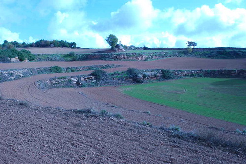
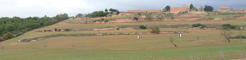
Oliver Rackham and his collaborators defined a basic typology of Mediterranean terraces related to their physical form and topographical location (Grove & Rackham, Citation2001, pp. 107–110; Rackham & Moody, Citation1996). They describe six main categories: parallel step terraces (either straight or curving around the contour), braided terraces (joined by zigzags) (Figure ), check-dams (across gullies or valleys), pocket terraces (often around individual trees), terraced fields (whose outer boundaries are terraced) and false terraces (bulldozed with machines). All types of historic terraces can be fronted with drystone walls, though earth banks are also common.
Figure 1. Braided terraces being cultivated at l’Espanyol, Els Prats de Rei, Catalonia. Photo: Sam Turner, November 2014.
Given how widespread terraces are and the extensive studies dedicated to their ecological and agricultural functions (e.g. Arnáez, Lana-Renault, Lasanta, Ruiz-Flaño, & Castoviejo, Citation2015; García-Ruiz et al., Citation2010), it is perhaps surprising that their histories are still quite poorly understood. As noted above, earthwork features can be hard to date using either conventional artefactual dating or scientific methods. Archaeologists have argued that terraces existed from the Bronze Age onwards in parts of the Eastern Mediterranean (e.g. Harfouche, Citation2007), but historical references to terraces are either absent or ambiguous in antiquity, and there is little consensus amongst classicists about how common they were (Price & Nixon, Citation2005). The difficulty of dating them means that scholars have tended to regard likely medieval examples as exceptional, preferring to explain most terraces as the result of agricultural intensification in the eighteenth and nineteenth centuries (Grove & Rackham, Citation2001, pp. 113–115). Even prehistorians of the Mediterranean tend to follow historical arguments, which place the construction of most terrace systems in the post-medieval period (Blanchemanche, Citation1990; Walsh, Citation2014, pp. 177, 178).
Like others in the Mediterranean, the date and development of Catalan terrace systems remain unclear. A post-medieval origin is widely accepted by historians and archaeologists, as for example in the area of Les Garrigues south of Lleida (Boixadera et al., Citation2016). Nevertheless, the documentary sources hint at earlier origins in some cases. For ‘Old Catalonia’, the northern and eastern areas that formed the frontier region between Muslim Spain and the Carolingian empire from the ninth to eleventh centuries, many thousands of early documents survive relating to land grants (see e.g. Bolòs & Hurtado, Citation2012, 2015). They record the names of estates and settlements, which can often be identified today (Bolòs, Citation2004). Many such places are associated with terrace systems, which may also have early origins, like those of Sant Julià de Cerdanyola, which extend for nearly 3 km east of the present village (Bolòs, Citation2015, pp. 73–86; Torró, Citation2007). Archaeological excavations at Can Ruti, Badalona led Palet (Citation1997) to argue that a terrace system there was established between the eleventh and fourteenth centuries. Elsewhere deserted medieval settlements are associated with abandoned terrace systems, as at Vilosiu and Montestir (Bolòs, Citation2004, p. 328). One of the aims of our pilot study was to establish whether different types of terraces were established at different times.
The exact nature of terraces appears to vary widely in different parts of Catalonia depending on a range of factors such as topography, geology, soils, settlement pattern and farming practice. In some regions, terraces often have no walls, for example around Berga and in the lower Pyrenees, but in others rubble or even rough ashlar walls are widespread. In many places, there is clear evidence that the terrace walls have been rebuilt on several occasions: it is important to note that there is no reason why the terrace itself and the retaining wall should necessarily be contemporary (Bolòs, Citation2004; p. 328). Step terraces, braided terraces, terraced fields and check-dams are the most widespread types. They are known by several names, including terrasses, feixes and bancals (Boixadera et al., Citation2016; Bolòs, Citation2004, p. 328). Check-dams are widely used to create level valley-bottom fields known as comes (singular coma) or commellars. The word feixes, like the equivalent Provençale term faïsses (Grove & Rackham, Citation2001, p. 113), means ‘terrace’ today but also ‘strip’ in the medieval documents. It seems likely that feixes simply meant long, narrow plots of cultivated land whether found on a steep mountainside or in flatter lowlands. This highlights the importance of understanding not only the history of individual plots but also how they were articulated in wider field systems, a topic that has been neglected in previous studies of terraces (Puy, Balbo, & Bebenzer, Citation2016). The relationships between terraces and other features are crucial for understanding how the historic landscape developed.
The broad historic character of the Catalan landscape has been the focus of recent research, which has used GIS to integrate data from archaeology, documentary records, historic maps and remote sensing (Bolòs, Citation2010, 2015). Through the long-term perspective of the historical geographer, a series of case studies have yielded new insights on the development of historic landscapes. The results suggest that many field systems have their origins in the medieval period (e.g. the so-called parellades, which resemble the ‘co-axial’ fields identified elsewhere in Europe: Bolòs, Citation2015, p. 111), and that some were probably laid out with reference to even earlier patterns of Roman fields. Although signs of ancient origins occur frequently across Catalonia, such interpretations rely on the detection of shared alignments in roads, field boundaries and other linear features: firmly dated evidence is rare. Recent critiques of these geographical approaches have encouraged our team to consider whether more robust methods for dating historic features might be developed (e.g. Bolòs, Citation2015, p. 94; Chouquer, Citation2015; Lavigne, Citation2003; Williamson, Citation2016).
Historic landscape characterisation
In an attempt to move beyond archaeology’s traditional site-based focus, our research has used GIS and HLC (other recent HLCs in Catalonia include Menàrguens and Almacelles: Bolòs & Bonales, Citation2013, 2015). HLC is a method that presents an interpretation of the historic character of the whole landscape (Turner, Citation2006). It was first developed in England (Herring, Citation1998) but has subsequently been used to inform landscape management, planning and research throughout the UK and elsewhere in Europe (e.g. Crow & Turner, Citation2009; Crow, Turner, & Vionis, Citation2011; Fairclough & Herring, Citation2016). An HLC map classifies the whole landscape into a series of GIS polygons, which reflect particular categories or ‘types’ of historic landscape character. As such it is always concerned with patterns and groups rather than individual monuments or discrete features. The specific HLC types that are selected for use in each project vary according to the region under study and the foreseen applications of the resulting characterisation. The HLC types are generally defined at the outset with reference to previous research on the historic landscape of the study area.
An advantage of HLC is that it provides a way to interpret the historic character of the whole landscape (Herring, Citation2013). In our research, it has enabled us to address our first aim, namely to analyse and present how historic character varies in space (some results are presented in the discussion of the case studies below). A disadvantage of HLC is that it risks over-simplifying complex histories of development when there is insufficient evidence to support its interpretations (Austin, Citation2007). Even in regions with long traditions of landscape history, major challenges still exist in this respect: the hedgebanks of south-west England and north-west France provide good examples, since the date of their original construction remains largely unknown (Turner, Citation2007). In Catalonia and the Mediterranean, terraces present a similar problem. For this reason, our team has piloted a new methodology using luminescence profiling and dating techniques. The results can be integrated into the HLC to add a new level of detail to the interpretations of landscape development presented in the characterisation.
OSL profiling and dating
A practical method for dating the establishment and development of terrace systems needs to comprise minimally intrusive fieldwork (to prevent excessive damage to potentially fragile features) that can be carried out rapidly by a small, mobile team (to minimise costs). Conventional OSL dating has been used for the last couple of decades to date archaeological deposits during excavations. Luminescence originates as a consequence of energy deposited within certain minerals, typically quartz and feldspar in response to naturally occurring ionising radiation in the samples and its environment. Luminescence signals can be erased by either heat or exposure to daylight; for the latter, exposure to light during the erosional or transport phases acts as the zeroing mechanism. The enclosure of the sediment after final deposition protects it from light and allows the accumulation of luminescence signals that can be used for age estimation. The luminescence age is determined by combining determinations of the radiation dose equivalent to the signals recovered from the samples (the equivalent dose), with measurements of the radiation dosimetry of the sample and its environment (the dose rate); the age is the quotient of equivalent dose over dose rate (Yukihara & McKeever, Citation2011).
The innovation applied in our research was to use a field profiling method, which enables luminescence stratigraphies to be created on-site and linked immediately to soil profiles. It was the first time this method had been applied to agricultural terraces, though it has previously been used in archaeological excavations and palaeoenvironmental studies (Kinnaird, Sanderson, & Woodward, Citation2012; Portenga & Bishop, Citation2016). The technique has two key advantages. First, it enables the field team to adapt their sampling strategy in real time in order to maximise the effectiveness of fieldwork. Second, and most significantly, in combination with laboratory profiling and OSL dating, it enables us to assess the relative chronology of the whole sediment profile rather than relying on just one or two quantitative dates from arbitrarily selected points somewhere in the profile. Field profiling was undertaken using a SUERC portable luminescence reader, which records both infra-red stimulated luminescence (IRSL) and OSL from bulk sediments (Sanderson & Murphy, Citation2010). Laboratory profiling and conventional quantitative quartz OSL dating were completed at the SUERC laboratories in accordance with established protocols (Ghilardi et al., Citation2015; Kinnaird, Sanderson, & Bigelow, Citation2015). A full description of the methods and results of the dating programme are published in a separate paper (Kinnaird, Bolòs, Turner, & Turner, Citation2017).
Four case studies from western Catalonia
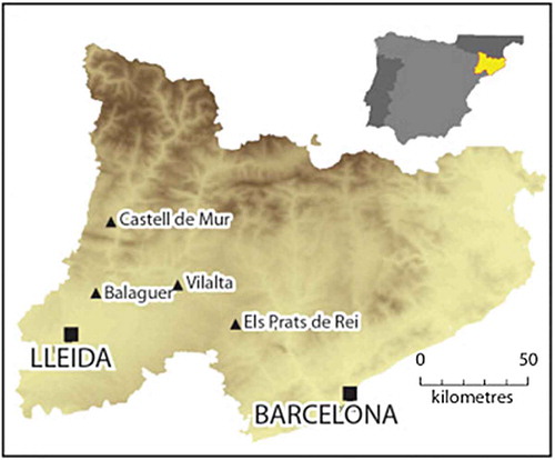
Four case-study sites were examined in two short field seasons in November 2013 and November 2014. Fieldwork had two aims: first, to verify the HLC types we were developing based on GIS data; second, to collect samples for luminescence profiling and dating from a series of contrasting types of terrace (Figure ).
Figure 2. Locations of four case studies in western Catalonia. (Map: Alex Turner).
Balaguer
Our first study area lies on the old road between the early medieval fortress and medina at Pla d’Almatà (Balaguer) and Castelló de Farfanya, which climbs gently as it travels north-west. Both the road and many of the large fields on the alluvium below the low marl and sandstone ridge of Serra del Bisbe and La Garriga have the same general orientation as a Roman field pattern identified elsewhere in the valley of the river Segre as ‘Ilerda G’ (Bolòs, Citation2015, pp. 89, 90; ICGC, Citation2007).
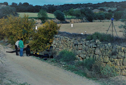
Initial reconnaissance identified a number of field and terrace types, which appeared to have different histories (Bolòs, Citation2015, p. 94). In the bottom of the narrow coombes cutting down from the ridge, check-dams create comes with stone-faced terrace walls, some over 2 m high (Figure ). Fields with stepped contour terraces are frequent on the hillsides whilst the steepest slopes have small areas of very straight stepped terraces.
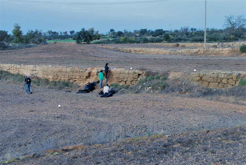
Figure 3. Fieldwork on the Balaguer-Castelló road (looking north-west). Arrows indicate the location of profiles taken from the stone-faced check-dam in the foreground and the earth bank in the background, which delimits the gently-sloping terraced field behind. Photo: Sam Turner, November 2014.
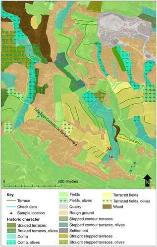
On more gently sloping valley sides, earth-faced banks define larger terraced fields used for arable and extensive olive cultivation in the nineteenth and early twentieth centuries. To the south of the road, large fields on gently rolling alluvial land were formerly divided into straight stepped terraces. Mechanised farming led to the removal of many terraces in the late twentieth century, but their remains show clearly as cropmarks in conventional and infrared air photos (ICGC, Citation2016). Such terraces were commonly fitted into the pre-existing fields, which suggests a relatively recent origin (perhaps in the eighteenth or nineteenth centuries), though neither the fields nor terraces have been firmly dated (Bolòs, Citation2015, p. 94) (Figure ).
Figure 4. HLC of the Balaguer case-study area. (Includes data © Institut Cartogràfic i Geològic de Catalunya, 2016. http://www.icc.cat/vissir/).
To address the chronology of two types of fields, we sampled for luminescence profiling and dating in a coma exactly halfway along the old road between Balaguer and Castelló de Farfanya. Historic occupation of the immediate vicinity is shown by the discovery of early medieval burials nearby at Les Taütetes (Fité & Bolòs, Citation1994), and by late twelfth and early thirteenth century records concerning ‘towers’ (perhaps small settlements) and their estates on the same road, though it is notable that few medieval documentary sources survive for this area.
Two locations were sampled to investigate (1) a stone-faced check-dam about 1.5 m high, which lies across the coma and immediately next to the road and (2) the earth bank of an adjacent terraced field. The luminescence profiles of both features demonstrated the build-up of soils over time with a normal age-depth progression. Laboratory profiling and OSL dating of the lowest preserved soils behind the check-dam suggested a date of construction in the sixteenth or early seventeenth century (AD 1630 ± 20 (0.39 ± 0.02 ka; SUTL2744)). The earth bank of the terraced field appeared to have a similar chronology, with a stony horizon around 0.9 m below modern ground level thought to indicate stabilisation of the ground surface at the time of construction. Dating samples positioned to either side of this layer suggested the terrace was created in the later Middle Ages (OSL dates provided a terminus post quem AD 1290 ± 50 (0.73 ± 0.05 ka; SUTL2746) and terminus ante quem of AD 1490 ± 40 (0.53 ± 0.04 ka; SUTL2745; Kinnaird et al., Citation2017, p. 74).
This evidence suggests that the terraced fields and comes in this area should probably be regarded as late medieval and early modern in date. The coma in this small valley may have been created to conserve sediments that had begun to be eroded as a result of arable farming in the fields to either side.
Ca l’Espanyol, Els Prats de Rei (Anoia)
The dissected landscape of Oligocene sandstones and shales around Els Prats de Rei provides a marked contrast to the previous case study in both physical and cultural terms, with much woodland and many small, scattered settlements in steep, isolated valleys.
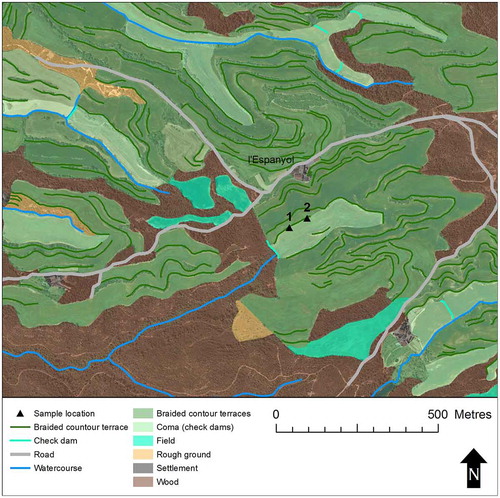
The terraces in the local area are mainly of two types. Check-dams form comes in the valley-bottoms whilst braided terraces capitalise on natural benches in the bedrock and roughly follow the contours of the valley sides (Figure ). Both have been ploughed extensively with machines since the mid-twentieth century, and there has been a notable level of consolidation and bulldozing of old terrace boundaries to create new access routes. Nevertheless, the basic organisation and grain of the historic pattern appear to be largely preserved in the modern landscape across a large area.
Figure 5. General view (looking north-west) of l’Espanyol, Els Prats de Rei, showing the settlement above the valley with braided terraces. The arrows indicate the location of luminescence profiles taken from the lowest terrace. Photo: Sam Turner, November 2014.
Field profiles and dating samples were taken from the bottom of the small valley immediately to the east of the hamlet of Ca l’Espanyol and 2.8 km south-east of Els Prats de Rei. It is likely that the settlement pattern of this area has medieval origins; a rock-cut dwelling on a rocky ridge 300 m south of l’Espanyol is thought to be the remains of a medieval hermitage or oratory (Enrich, Citation1992).
The profiles at l’Espanyol came from two locations on the lowest valley-side terrace above the coma. This terrace was preserved as a substantial earthwork with a fragmentary drystone wall along its whole surviving length (c. 140 m). Both profiles demonstrated a normal age-depth progression with archaeological soils of seventeenth- to eighteenth-century date preserved beneath modern plough disturbance (Figure ). A dating sample from the lowest preserved soil in the eastern profile provided a terminus ante quem for construction of the terrace of AD 1440 ± 30 (0.57 ± 0.03 ka; SUTL2571). This evidence strongly suggests that the feature originated in the late medieval period at the latest, and that it was used throughout the early modern period for arable farming. It is likely that similar braided terraces, which extend across the surrounding landscape, have similar histories (Figure ).
Figure 6. Luminescence profiles from l’Espanyol showing increasing age with depth (Kinnaird et al., Citation2017, Figure 6).
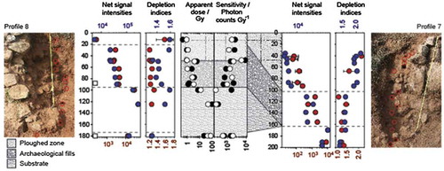
Figure 7. HLC of l’Espanyol case-study area. (Includes data © Institut Cartogràfic i Geològic de Catalunya, 2016. http://www.icc.cat/vissir/).
Vilalta (Vilanova de l’Aguda, la Noguera)
Vilalta is a small nucleated village in the Segarra region occupying a low hilltop (c. 465 m above sea level) about 3.5 km west of the Llobregós River. It is first mentioned in historical sources in AD 1176, though it was perhaps founded a hundred years before (Bolòs, Citation2015, p. 99; Tugues, Citation1994).
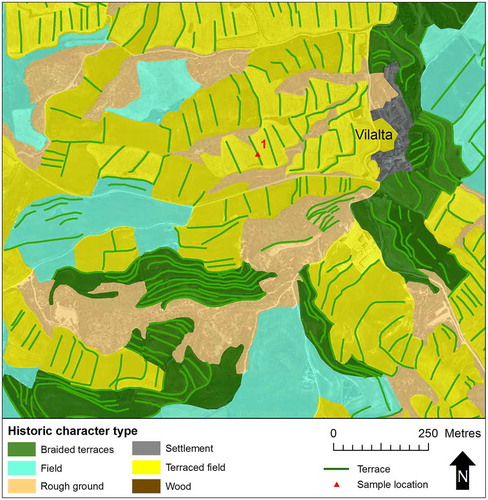
The underlying Oligocene marl siltstones and sandstones with interbedded conglomerates slope gently away from the village on the west side, though steeper hillsides lie immediately to the east and the south-west (ICGC, Citation2007). The topography has a strong relationship to the historic character: on the gentler slopes to the west, terraced fields stretch away from the village, but the steeper slopes have braided and stepped terrace systems (Figure ). Using analogies with other places, Bolòs suggested that areas to the east and west of the village might preserve ancient field patterns given their shared orientations with Lleida’s ‘Ilerda A’ and ‘D’ field systems, which may belong to the Roman period (Bolòs, Citation2015, p. 100). The terraces and other boundaries of the whole Segarra region are characterised by substantial stone walls of rough ashlar built in the local sandstone: all the terrace walls we observed around Vilalta have this form.
Figure 8. HLC of the Vilalta case-study area. (Includes data © Institut Cartogràfic i Geològic de Catalunya, 2016. http://www.icc.cat/vissir/).
A single stone-built terrace 360 m west of the village was sampled for luminescence profiling and dating (Figure ). We took four profiles, each up to 2 m high. The profiles suggested the survival of archaeological soils dating from the twelfth to the seventeenth centuries below the level disturbed by modern ploughing. A date of construction around the beginning of the thirteenth century was suggested by an OSL terminus post quem from strata adjacent to the wall foundations of AD 1230 ± 40 (0.79 ± 0.04 ka, SUTL2750) and a terminus ante quem from the lowest preserved soil in the sequence of AD 1200 ± 60 (0.81 ± 0.06 ka, SUTL2748). This evidence confirms the medieval origins of this terraced field. Given that it is indistinguishable from all the other terraced fields around Vilalta, it seems most likely that the whole system was established in the Middle Ages and has subsequently been exploited more or less continuously for arable.
Figure 9. Fieldwork at Vilalta: profiling the terraced field boundary. The rough ashlar walls of the terraced fields are typical of the region. Photo: Sam Turner, November 2014.
Mur (Pallars Jussà)
Our final example was located in a mountainous region 5.5 km north of the Montsec ridge, on the west side of the Noguera Pallaresa River. The Castell de Mur stands at 900 m above sea level on a steep promontory whose precipitous sides drop more than 250 m to the north and south. The castle itself is thought to date to the eleventh and twelfth centuries, with possible early medieval antecedents, whilst the adjacent collegiate church of Santa Maria de Mur was consecrated in the mid-eleventh century (Sancho, Citation2009). A deserted settlement with a ruined medieval church stands on the ridge about 220 m to the north-west as it rises gently towards the summit of les Mosques (1031 m) (Figure ).
Figure 10. Castell de Mur. The steep flanks of this mountainous ridge are covered in step contour terraces and braided terraces, with patches of recently planted olives. The white triangles indicate sites sampled for luminescence profiling. (Photo: © Institut Cartogràfic i Geològic de Catalunya, August 2015. http://www.icc.cat/vissir/).
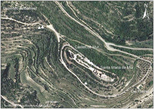
The landscape of the promontory is characterised by stepped contour terraces and braided terraces with stone walls, many over 2 m high and with evidence for phases of repair and rebuilding. Close to the castle, a complex historic irrigation system of uncertain date includes a number of small cisterns and aqueducts. Air photographs from the mid-twentieth century show that although the terrace systems have been altered little since that time, the straight lines of olive trees are mostly recent additions (except around the hamlet of Cal Franxo, 300 m to the south-east of the castle).
Luminescence profiles were taken from two separate locations, two high, stepped contour terraces with rubble retaining walls around 200 m north-west of the castle and a further contour terrace with neatly coursed rubble facing c. 150 m to its south-east. A terminus ante quem from the lowest fill of one of the step terraces to the north-west of the castle showed they were established before AD 1570 ± 50 (0.44 ± 0.05 ka; SUTL2756). Remodelling of the system in the early nineteenth century was demonstrated by quartz OSL SAR ages for strata enclosing a prominent stone horizon in the profile at 1.40 m depth (AD 1810 ± 15 (0.21 ± 0.02 ka; SUTL27540 and AD 1805 ± 30 (0.21 ± 0.03 ka; SUTL2755). Meanwhile, the foundation fill of the contour terrace south-east of the castle was dated to AD 1710 ± 20 (0.31 ± 0.02 ka; SUTL2757). The luminescence profiling and dating around the Castell de Mur showed that even though the step contour terraces here are now abandoned, they were used, rebuilt and remodelled throughout the early modern period and into the nineteenth century.
Discussion and conclusions
At the outset, our study had two aims: to analyse and present how historic character varies across space and to help explain when different types of historic character originated. In pursuit of these goals, we developed an interdisciplinary methodology that integrated techniques from history, historical geography, archaeology and environmental science through GIS.
Using an innovative luminescence profiling and dating technique, we were able to demonstrate conclusively for the first time that terrace systems in Catalonia originated in the Middle Ages and the early modern period (Kinnaird et al., Citation2017). Furthermore, we were able to show that different types of terraces originated and developed in different ways. For example, the neatly terraced fields with rough ashlar walls around Vilalta were dated to the early thirteenth century with a more or less continuous history of use up until modern times. By contrast, the massive contour terraces on the vertiginous slopes of the Castell de Mur appear to have been constructed by the late sixteenth century, remodelled in the early nineteenth century and deserted during the twentieth century. A summary of these results is presented in Table .
Table 1. Case-study terraces and HLC types.
The information generated through the luminescence profiling and dating enables us to develop the HLC typology with increased confidence since it underpins our chronological understanding of different categories of terraces. This represents an important advance with the potential to significantly improve our knowledge of how terraced landscapes have developed over time and understand them in relation to their historical contexts: both have been virtually impossible up until now. In turn, the HLC affords the capability to generate a detailed picture of where different types of terraces and fields occur.
This pilot study has only considered a small number of case studies including at most two terraces in each system. As Puy et al. (Citation2016) have noted, researchers have neglected terrace systems as a whole. A clear imperative for future research is to identify and sample a larger number of terraces from one or more discrete systems with the aim of discovering whether episodes of construction and modification were really coherent and planned, or whether farmers took a more piecemeal attitude to building terraces.
In conclusion, it is important to note the potential for combining HLC and luminescence profiling with additional soil science approaches. We now have the capacity to understand when and where change occurred in historic field systems in much more detail than has previously been possible. Thanks to the relatively low cost of OSL profiling, such methods could be applied over much larger areas as part of regional or national programmes of historic landscape mapping. By integrating other research techniques which can address soil management and quality or agricultural regimes (using, e.g. pollen, phytoliths, biomarkers and DNA), it should be possible to write detailed landscape histories using the soil itself as the primary source. This will not only reduce our dependence on fragmentary written and archaeological sources, but will also enable us to make better use of them by exploring the contradictions and tensions which become evident.
Finally, there is now considerable scope to develop new historical studies that will inform future landscape management. It is clear that different human activities in the past have led to the creation of both highly sustainable and productive landscapes and damaging consequences like soil erosion and flooding. Our improving ability to understand the detailed chronologies and spatial characteristics of historic landscape change should enable much more effective collaboration between historians, archaeologists and environmental scientists. The methods we outline in this paper provide the first steps towards detailed knowledge about when, where and how fields and terrace systems have changed in the past. Future research will enable us to examine the historic impact of innovations like terracing and the precise effects of changes such as abandonment or mechanisation. This knowledge will not only inform our understanding of past landscapes, but will also help underpin strategies for responsible and sustainable management in the future.
Funding
This work was supported by Ministerio de Economía y Competitividad, Spain [grant number MINECO HAR2012-35022].
Disclosure statement
No potential conflict of interest was reported by the authors.
Acknowledgements
We were helped in the field by Joan Lluís, Anna Perera, Natalia Salazar, Marta Sancho and Alex Turner and in the laboratory by David Sanderson. We thank them all for their support and insights.
References
- Arnáez, J. , Lana-Renault, N. , Lasanta, T. , Ruiz-Flaño, P. , & Castoviejo, J. (2015). Effects of farming terraces on hydrological and geomorphological processes. A review. Catena , 128 , 122–134. doi:10.1016/j.catena.2015.01.021
- Augé, M. (1995). Non-places. Introduction to an anthropology of supermodernity . London: Verso.
- Austin, D. (2007). Character or caricature? Concluding discussion Landscapes , 8 (2), 92–105.10.1179/lan.2007.8.2.92
- Ballesteros-Arias, P. , & Criado-Boado, F. (2009). El paisaje agrario medieval en Galicia. Herramientas metodológicas [The medieval agrarian landscape in Galicia. Methodological tools]. In J. Bolós & E. Vicedo (Eds.), Poblament, territori i historia rural. VI Congrés sobre Sistemes Agraris, Organització Social i Poder Local (pp. 599–612). Lleida: Institut d’Estudis Ilerdencs. Retrieved from http://hdl.handle.net/10261/24841
- Beckers, B. , Schütt, B. , Tsumkamoto, S. , & Frechen, M. (2013). Age determination of Petra’s engineered landscape e optically stimulated luminescence (OSL) and radiocarbon ages of runoff terrace systems in the Eastern Highlands of Jordan. Journal of Archaeological Science , 40 (1), 333–348.10.1016/j.jas.2012.06.041
- Bevan, A. , Conolly, J. , Colledge, S. , & Stellatou, A. (2012). The long-term ecology of agricultural terraces and enclosed fields from Antikythera. Greece. Human Ecology , 41 (2), 255–272. doi:10.1007/s10745-012-9552-x
- Blanchemanche, P. (1990). Bâtisseurs de Paysages: Terrassement, épierrement et petite hydraulique agricoles en Europe, XVIIe-XIXe siècles [Landscape builders: Terracing, stone clearance and agricultural water management in Europe, 17th-19th centuries]. Paris: La Maison des Sciences de l’Homme.
- Boixadera, J. , Riera, S. , Vila, S. , Esteban, I. , Albert, R. , Llop, J. , & Poch, R. (2016). Buried A horizons in old bench terraces in Les Garrigues (Catalonia). Catena , 137 , 635–650. doi:10.1016/j.catena.2014.08.017
- Bolòs, J. (2004). Els Orígens Medievals del Paisatge Català. L’arqueologia del paisatge com a font per a conèixer la història de Catalunya [The medieval origins of the Catalan landscape. Landscape archaeology as a source for encountering the history of Catalonia]. Barcelona: Institut d’estudis Catalans.
- Bolòs, J. (2010). PaHisCat: A project to discover the landscape of the past and manage the countries of the future. La caracterització del paisatge històric. Territori i Societat: El paisatge històric , 5 , 371–407.
- Bolòs, J. (2015). Paisatges i transicions: Canvis i continuïtats al llarg de la història [Landscapes and transitions. Changes and continuities through history]. El pasisatge en èpoques de transició al llarg dels darrers dos mil anys. Territori i Societat: El paisatge històric , 7 , 59–126.
- Bolòs, J. , & Bonales, J. (2013). Atlas històric de Menàrguens [Historic atlas of Menarguens]. Lleida: Ajuntament de Menàrguens.
- Bolòs, J. , & Bonales, J. (2015). Atlas històric d’Almacelles [Historic atlas of Almacelles]. Lleida: Ajuntament d’Almacelles.
- Bolòs, J. , & Hurtado, V. (2012). Atles dels Comtats de Pallars i Ribagorça (v806–v998) [Atlas of the counties of Pallars and Ribagorca]. Barcelona: Rafael Dalmau.
- Bolòs, J. , & Hurtado, V. (2015). Atles dels Comtats de Cerdanya i Berga (v788–v990) [Atlas of the counties of Cerdanya and Berga]. Barcelona: Rafael Dalmau.
- Bowden, M. , & McOmish, D. (2011). A British tradition? Mapping the archaeological landscape Landscapes , 12 (2), 20–40.
- Chouquer, G. (2015). Les parcellaires médiévaux en Émilie et en Romagne. Centuriations et trames coaxiales. Morphologie et droit agraires [Medieval field patterns in Emilia-Romagna. Centuriation and coaxial organisation. Morphology and agrarian law]. Paris: France Internationale pour l’Expertise Foncière. Retrieved from https://www.formesdufoncier.org/pdfs/00-EmiRom-TOTAL.pdf
- CoE . (2000). European Landscape Convention . Council of Europe Treaty 176. Retrieved from http://www.coe.int/en/web/conventions/full-list/-/conventions/treaty/176
- Crow, J. , & Turner, S. (2009). Silivri and the Thracian hinterland of Istanbul: An historic landscape. Anatolian Studies , 59 , 167–181.10.1017/S0066154600000958
- Crow, J. , Turner, S. , & Vionis, A. (2011). Characterizing the historic landscapes of Naxos. Journal of Mediterranean Archaeology , 24 (1), 111–137.
- Decker, M. (2016). The byzantine dark ages . London: Bloomsbury.
- Doneus, M. , Briese, C. , Fera, M. , & Janner, M. (2008). Archaeological prospection of forested areas using full-waveform airborne laser scanning. Journal of Archaeological Science , 35 (4), 882–893.10.1016/j.jas.2007.06.013
- Enrich, H. J. (1992). El roc foradat de Ca n’Espanyol [The rock-cut site at Ca n’Espanyol]. Catalunya Romànica (Vol. 19, El Penedès, l’Anoia, pp. 474–475). Barcelona: Enciclopèdia Catalana.
- Fairclough, G. , & Herring, P. (2016). Lens, mirror, window: Interactions between historic landscape characterisation and landscape character assessment. Landscape Research , 41 (2), 186–198.10.1080/01426397.2015.1135318
- Fité, F. , & Bolòs, J. (1994). Torre i necròpoli de les Taütetes [Tower and necropolis at les Tautetes]. Catalunya Romànica (Vol. 19, El Penedès, l’Anoia, p. 346). Barcelona: Enciclopèdia Catalana.
- Francovich, R. , Patterson, H. , & Barker, G. (Eds.). (2000). Extracting meaning from ploughsoil assemblages . Oxford: Oxbow.
- Fyfe, R. , Woodbridge, J. , & Roberts, N. (2015). From forest to farmland: Pollen-inferred land cover change across Europe using the pseudobiomization approach. Global Change Biology , 21 , 1197–1212. doi:10.1111/gcb.12776
- Gadot, Y. , Davidovich, U. , Anvi, G. , Anvi, Y. , Piasetzky, M. , Faershtein, G. , … Porat, N. (2016). The formation of a Mediterranean terraced landscape: Mount Eitan, Judean Highlands, Israel. Journal of Archaeological Science: Reports , 6 , 397–417. doi:10.1016/j.jasrep.2016.02.028
- García-Ruiz, J. M. , Lana-Renault, N. , Beguería, S. , Lasanta, T. , Regüés, D. , Nadal-Romero, E. , … Alatorre, L. C. (2010). From plot to regional scales: Interactions of slope and catchment hydrological and geomorphic processes in the Spanish Pyrenees. Geomorphology , 120 , 248–257. doi:10.1016/j.geomorph.2010.03.038
- Ghilardi, M. , Sanderson, D. , Kinnaird, T. , Bicket, A. , Balossino, S. , Parisot, J.-C. , … Fleury, J. (2015). Dating the bridge at Avignon (south France) and reconstructing the Rhone River fluvial palaeo-landscape in Provence from medieval to modern times. Journal of Archaeological Science: Reports , 4 , 336–354.10.1016/j.jasrep.2015.10.002
- Grove, D. , & Rackham, O. (2001). The nature of Mediterranean Europe: An ecological history . New Haven, CT : Yale University Press.
- Hall, D. (1995). The open fields of northamptonshire . Northampton: Northamptonshire Record Society.
- Harfouche, R. (2007). Histoire des paysages méditerranéens terrassés: Aménagements et agriculture [The history of Mediterranean terraced landscapes. Management and agriculture]. British archaeological reports international series 1634. Oxford: Archaeopress.
- Herring, P. (1998). Cornwall’s historic landscape. Presenting a method of historic landscape character assessment . Truro: Cornwall County Council.
- Herring, P. (2013). Valuing the whole historic landscape. In P. Howard , I. Thompson , & E. Waterton (Eds.), Routledge companion to landscape studies (pp. 166–178). London: Routledge.
- Hritz, C. (2014). Contributions of GIS and satellite-based remote sensing to landscape archaeology in the middle east. Journal of Archaeological Research , 22 (3), 229–276. doi:10.1007/s10814-013-9072-2
- ICGC . (2016). VISSIR v.3.26 . Barcelona: Author. Retrieved from http://www.icc.cat/vissir/
- ICGC . (2007). Base geològica 1:50,000 [Solid geology 1:50,000]. Barcelona: Author. Retrieved from http://www.icc.cat/vissir/
- Kinnaird, T. , Sanderson, D. , & Woodward, N. (2012). Applying luminescence methods to geoarchaeology: A case study from Stronsay, Orkney. Earth and Environmental Science Transactions of the Royal Society of Edinburgh , 102 (3), 191–200. doi:10.1017/S1755691012011115
- Kinnaird, T. , Sanderson, D. , & Bigelow, G. (2015). Feldspar SARA IRSL dating of very low dose rate aeolian sediments from Sandwick South, Unst, Shetland. Quaternary Geochronology , 30 (Part B), 168–174. doi:10.1016/j.quageo.2015.02.019
- Kinnaird, T. , Bolòs, J. , Turner, A. , & Turner, S. (2017). Optically-stimulated luminescence profiling and dating of historic agricultural terraces in Catalonia (Spain). Journal of Archaeological Science , 78 , 66–77. doi:10.1016/j.jas.2016.11.003
- Koborov, D. , & Borisov, A. (2013). The origins of terraced field agriculture in the Caucasus: New discoveries in the Kislovodsk basin. Antiquity , 87 , 1086–1103.10.1017/S0003598X00049887
- Lavigne, C. (2003). De nouveaux objets d’histoire agraire pour en finir avec le bocage et l’openfield [New objects in agrarian history: finishing with ‘bocage’ and ‘openfield’]. Études Rurales , 167–168 , 133–185.
- Oosthuizen, S. (2006). Landscapes decoded: The origins and development of Cambridgeshire’s medieval fields . Hatfield: University of Hertfordshire Press.
- Palet, J. M. (1997). Estudi territorial del Pla de Barcelona. Estructuració i evolució del territori entre l’època íbero-romana i altmedieval. Segles II-I aC – x-xi dC [Territorial study of the Pla de Barcelona. Structure and evolution of the territory between the Ibero-Roman period and the early Middle Ages (2nd-1st centuries BC to 10th-11th centuries AD)]. Barcelona: Ajuntament de Barcelona.
- Portenga, E. , & Bishop, P. (2016). Confirming geomorphological interpretations based on portable OSL reader data. Earth Surface Processes and Landforms , 41 , 427–432. doi:10.1002/esp.3834
- Price, S. , & Nixon, L. (2005). Ancient Greek agricultural terraces: Evidence from texts and archaeological survey. American Journal of Archaeology , 109 , 665–694.10.3764/aja.109.4.665
- Puy, A. , & Balbo, A. (2013). The genesis of irrigated terraces in al-Andalus. A geoarchaeological perspective on intensive agriculture in semi-arid environments (Ricote, Murcia, Spain). Journal of Arid Environments , 89 , 45–56. doi:10.1016/j.jaridenv.2012.10.008
- Puy, A. , Balbo, A. , & Bebenzer, O. (2016). Radiocarbon dating of agrarian terraces by means of buried soils. Radiocarbon , 58 (2), 345–363.10.1017/RDC.2015.21
- Quirós Castillo, J. A. , Nicosia, C. , Polo-Díaz, A. , & Ruiz del Árbol, M. (2013). Agrarian archaeology in northern Iberia: Geoarchaeology and early medieval land use. Quaternary International , 346 , 56–68.
- Rackham, O. , & Moody, J. (1996). The making of the Cretan landscape . Manchester, NH : Manchester University Press.
- Sancho, M. (Ed.). (2009). Mur, la història d’un castell feudal a la llum de la recerca històrico-arqueològica [Mur, the history of a feudal castle in the light of historical-archaeological research]. Tremp: Garsineu.
- Sanderson, D. , & Murphy, S. (2010). Using simple portable OSL measurements and laboratory characterisation to help understand complex and heterogeneous sediment sequences for luminescence dating. Quaternary Geochronology , 5 , 299–305.10.1016/j.quageo.2009.02.001
- Torró, S. (2007). Terrasses irrigades a les muntanyes valencianes: les transformacions de la colonització Cristiana [Irrigated terraces of the Valencian mountains: Transformations of the Christian colonization]. In J. Bolòs (Ed.), Estudiar i gestionar el paisatge historic medieval. Territori i Societat a l’Edat Mitjana (pp. 81–143). Lleida: Universitat de Lleida.
- Trondman, A.-K. , Gaillard, M. , Mazier, F. , Sugita, S. , Fyfe, R. , Nielsen, A. , … Wick, L. (2015). Pollen-based quantitative reconstructions of Holocene regional vegetation cover (plant-functional types and land-cover types) in Europe suitable for climate modelling. Global Change Biology , 21 , 676–697. doi:10.1111/gcb.12737
- Tugues, J. (1994). Sant Salvador de Vilalta [St Salvador, Vilalta]. Catalunya Romànica (Vol. 17. La Noguera, p. 66). Barcelona: Enciclopèdia Catalana.
- Turner, S. (2006). Historic landscape characterisation: A landscape archaeology for research, management and planning. Landscape Research , 31 (4), 385–398.10.1080/01426390601004376
- Turner, S. (2007). Ancient country: The historic character of rural Devon . Exeter: Devon Archaeological Society.
- Walsh, K. (2014). The archaeology of mediterranean landscapes. Human-environment interaction from the Neolithic to the Roman period . Cambridge: Cambridge University Press.
- Watteaux, M. (2005). Sous le bocage, le parcellaire… [Below the ‘bocage’, the field pattern...] Études Rurales , 175–176 , 53–80.
- Williamson, T. (2016). The ancient origins of medieval fields: A reassessment. Archaeological Journal , 173 (2), 264–287. doi:10.1080/00665983.2016.1191129
- Yukihara, E. , & McKeever, S. (2011). Optically stimulated luminescence: Fundamentals and applications . Chichester: Wiley. doi:10.1002/9780470977064.ch1
- Zarinebaf, F. , Bennet, J. , & Davis, J. L. (2005). A historical and economic geography of Ottoman Greece: The southwestern Morea in the 18th century . Hesperia Supplement 34. Princeton, NJ: American School of Classical Studies at Athens.