
ABSTRACT
Historically, the cultural landscape of northern Haiti has been severely impacted by Amerindian, Spanish, and African cultures. Historical accounts often consider only the transformations that left visible imprints in the environment, neglecting or overlooking other social changes. This research provides a new set of data, built upon results from mainly archaeological surveys. A landscape biographical approach is applied to capture the historic development of the Fort-Liberté region, Haiti. The discussion shows that the history of the region can be understood as a landscape palimpsest resulting from complex relations between different cultural groups over time.
1. Introduction
Christopher Columbus reached the coast of northern Haiti in 1492. His logbook describes the region as a ‘paradise valley’ by a large number of indigenous villages with well-cultivated agricultural fields and beautiful environmental features (Dunn & Kelly, Citation1989; Morison, Citation1940). Although the first Spanish fort in the New World (La Navidad, which was built with wood from the wrecked Santa Maria), did not last until Columbus’ fleet returned in 1493, from the first year onward the Spanish invasion had a rapid and dramatic impact on the island’s indigenous population. In the seventeenth century, French colonists settled in the region, including Fort-Liberté, which had previously been occupied by the Spaniards. With a huge contribution from enslaved people, they transformed it into colonial plantations. At an early stage in the colonization process, the French settlers invested in the production of annatto (rocou) and tobacco, later replaced with indigo and sugar (Burnard & Garrigus, Citation2016; J. Cauna, Citation2003; J. D. Cauna, Citation2013; Dubois, Citation2004; Garrigus, Citation1993). In the eighteenth century, the French colony became the biggest sugar producer and the wealthiest colony in the New World (Burnard & Garrigus, Citation2016; J. D. Cauna, Citation2013; Dubois, Citation2004).
Regional archaeological surveys show that traces of Fort-Liberté’s history are still visible on the surface and in vestiges of indigenous settlements (Hofman et al., Citation2018; Jean, Citation2019; Koski-Karell, Citation2002; Moore & Tremmel, Citation1997; Rainey, Citation1941; Rouse, Citation1939, Citation1941). Spanish activity (Hamilton & Hodges, Citation1995) and large-scale French colonial plantations (Jean, Citation2019) represent the reuse of places and the successive reorganisation and rearrangement of Fort-Liberté’s landscape by diverse cultural groups through time.
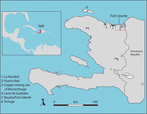
The purpose of this paper is to analyse the long-term transformations that occurred and to clarify the multi-layered aspects of these transformations during historical developments in the Fort-Liberté region of Haiti (). We study Amerindian living strategies that were disrupted by the rapid expansion of devastating Spanish colonisation and look at the subsequent French colonial rule, which significantly affected the appearance of the local environment. This region presents a unique opportunity to investigate the implementation of early colonial strategies over indigenous people and their land (e.g. Deagan, Citation1995; Dunn & Kelly, Citation1989; Hofman et al., Citation2018; Jean, Citation2019; Morison, Citation1940), and the way in which the colonists organised the landscape until Haitian independence in 1804. Currently, traces of the indigenous and colonial past remain visible in the region and, although heavily damaged through exposure, reveal a forgotten cultural heritage. For this, we use a biographical approach to landscape (Bloemers et al., Citation2010; Kolen & Renes, Citation2015; Pollard & Reynolds, Citation2002; Roymans et al., Citation2009) to discuss both the region’s transformations from the earliest indigenous settlement that dates to around 3000 BC up until the end of the colonial era in the early nineteenth century and the current uses of the archaeological heritage in the region.
Figure 1. The Spanish colonial activities in the North of Haiti including the Fort-Liberté region
2. Focus on the landscape
Landscapes are dynamic and constantly in transformation, arising from human–environmental interactions and intercultural relations between different groups (Ingold, Citation2000). These activities over different temporal scales generate, erase, and accumulate landscape manifestations as a complex palimpsest (Bailey, Citation2007). Landscape biographies are created by collecting narratives and meanings at each point in time, from the early history up to the present day (Bloemers et al., Citation2010; Kolen & Renes, Citation2015; Kolen et al., Citation2015), to represent the multivocal character of the past (Roymans et al., Citation2009, p. 356). The ʺlongstanding and complex interplay between the history of mentalities and values … social and economic developments and ecological dynamicsʺ (Roymans et al., Citation2009, p. 339) give it a multivocal dimension. This approach allows archaeologists and heritage practitioners to address and critically reflect upon the key questions regarding identity, memory, and cultural heritage that emerged from different historical processes (Bloemers et al., Citation2010; Kolen et al., Citation2015; Roymans et al., Citation2009). It enables direct action in heritage management and protection and can affect social perception (Palang & Peil, Citation2010; Palang et al., Citation2011; Roymans et al., Citation2009; Smith & Waterton, Citation2009; Sullivan & Mackay, Citation2012). Landscape biography provides insights into present-day transformations of landscapes and can be used to critique management and conservation practices that are currently in use (Bloemers et al., Citation2010; Kolen & Renes, Citation2015; Papmehl-Dufay, Citation2015; Roymans et al., Citation2009).
Through archaeological perspectives, scholars have studied the long-term historical dynamics in the Caribbean region. Recent studies have focused on the indigenous plantscape dynamics that benefitted the early Europeans’ survival and domination of the Caribbean (Pagán-Jiménez et al., Citation2020) and the pre-colonial landscape that was changed over time by colonial activity (e.g. Bain et al., Citation2018; Castilla-Beltrán et al., Citation2020, Citation2018; Hofman et al., Citation2020; Hofman & Keehnen, Citation2019; C. Hofman et al., Citation2020; Rivera-Collazo, Citation2015; Rivera-Collazo et al., Citation2018; Samson & Cooper, Citation2015).
The colonial forces caused profound social change, as well as an ecological impact on plants, animals, and forests (Kimber, Citation1988). Reinaldo Funes (Citation2008) shows, for example, in ‘physico-natural’ regional studies, how Cuban forests were impacted from indigenous times to the twentieth century. Here, in particular, the extensive production of sugar caused ecological disruption to land surfaces and forest.
The landscape of Saint-Domingue (now Haiti) has been studied for a variety of reasons. Initially, the plantation farming produced a rich agricultural landscape, but overexploitation through the centuries dramatically influenced the ecosystem. Moreau de Saint-Merry in 1797 described how intensification of sugar and coffee plantation was affecting the ecological dynamics of the colony. Over the past two decades, scholars have concentrated on the recent environmental and landscape change, particularly on modern land use—from deforestation to agroforestry (e.g. Bannister & Nair, Citation2003; Bellande, Citation2009; Churches et al., Citation2014; Dolisca et al., Citation2007; Jean-Denis et al., Citation2014; Sprenkle-Hyppolite et al., Citation2016; Tarter et al., Citation2016; Versluis & Rogan, Citation2010; White et al., Citation2013). However, studies have also focussed on a more distant past. For instance, Higuera-Gundy et al. (Citation1999) analysed the climate and environmental changes before and after the first human settlements in Haiti. Others focused on the dynamics of the Amerindian settlement before Columbus (Herrera Malatesta, Citation2018; Hofman et al., Citation2018; Jean, Citation2019; Koski-Karell, Citation2002) and the impacts of the French colonial system on the modification of landscape (e.g. Lindskog, Citation1998; Tarter et al., Citation2016). André Marcel D’Ans (Citation1987) tackles the Haitian landscape and its society, using mainly historical, anthropological, and linguistic perspectives. His analytical conclusion finds the landscape as ʺdes-indigenizedʺ (D’Ans, Citation1987, p. 317); namely, the native landscape is completely erased over time, as is evident in the disappearance of many components of the indigenous biodiversity and agricultural practices. The colonisation of the island served as the principal factor in long-term landscape transformation. This included the implementation of new agricultural techniques and infrastructures that reshaped the land and the introduction of new people, plants (e.g. sugar cane, coffee and indigo) and animals (e.g. cattle, pigs, goats, horses, and domestic poultry), which influenced the ecological dynamics. French colonial transformation created a ʺhybrid landscapeʺ, meaning an imperial transfer of seeds and machinery from other parts of the world to refashion Saint-Domingue economically, politically and aesthetically (Casid, Citation2005, pp. 30–31). The French reorganisation of the region led to a radical transformation of the region in which lived the Amerindian communities and the Spanish colonists. A landscape biographical approach captures the long-term historic development of the Fort-Liberté region, from the early human settlements up to the eighteenth century. This approach also addresses the use of archaeological sites by individuals today.
3. Note on region and methods
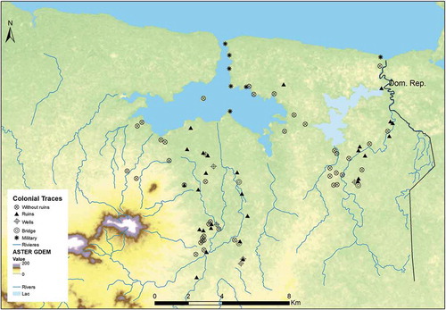
Fort-Liberté is a coastal sector of low elevation semi-arid and alluvial plains, surrounded by small hills situated between Manzanillo Bay and Caracol Bay, which are fed by permanent and intermittent rivers (). The endemic flora and fauna are highly biodiverse, but agricultural vegetation makes up the dominant vegetation type (Ménanteau & Vanney, Citation1997). Fort-Liberté has a large number of archaeological sites associated with the Amerindian settlement, colonial occupation, and the post-Haitian-independence era. A non-systematic archaeological survey covering around 200 km2 from the coast to the hinterlands was conducted during four field seasons 2014–2016 (Jean, Citation2019) to re-evaluate Amerindian activity (3000 BC–1492 AD) which had already been partly reported (Koski-Karell, Citation2002; Moore & Tremmel, Citation1997), and to draw a picture of European colonial occupation in this region. Material culture, here related to Amerindian and colonial activities, indicates a change in the landscape and its interpretation captures the cultural context. The interpretation of the data from an indigenous way of life through to the colonial period brings up vital information, not only about how the landscape evolves according to different uses, but also how the landscape is more than merely an exploitable natural resource and plays an important role in shaping human activities. The archaeological sites were recorded in GIS (Geographical Information System) to determine spatial patterns of past human activities and correlated with historic archive data, especially old French colonial maps, to capture how the plantation’s landscape was organised across this sector. By georeferencing historic maps, we determined different forms of land use during French colonial times. We also sought to investigate the contemporary meaning of the archaeological remains in order to engage with the non-linearity of landscape palimpsests. For this, we collected around 20 recorded and non-recorded narratives from individuals about their activities on and around archaeological sites (see Jean, Citation2019; Sonnemann & Jean, Citation2016).
Figure 2. The location of Fort-Liberté and its topography

4. The case of Fort-Liberté bay
4.1. The Amerindian settlement dynamics: 3000 BC–1492 AD
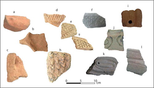
With the inclusion of previous archaeological studies, which also covered Tortuga Island (Koski-Karell, Citation2002; Moore & Tremmel, Citation1997), more than 300 Amerindian archaeological sites have been identified with different cultural components and mostly relating to the coastal regions of northern Haiti. The Fort-Liberté region may have contained some of the largest Amerindian settlements in northern Haiti (). For example, 164 traces of settlement have been documented in the area of study, with about half of them previously documented (Koski-Karell, Citation2002; Moore & Tremmel, Citation1997). The recent fieldwork consisted of revisiting and evaluating the sites, during which additional sites were identified. The studies revealed the earliest settlement dynamics characterised by distributions of both ground and flaked stone tools associated with shell mounds (Jean, Citation2019; Moore & Tremmel, Citation1997; Rainey, Citation1941; Rouse, Citation1939; Rouse, Citation1941). These sites are attributed to Archaic Age peoples who occupied Haiti from around 4500 BC till 600 AD (Koski-Karell, Citation2002; Moore, Citation1992). These societies probably performed horticulture, like other Archaic Age peoples in the Caribbean (Hofman & Antczak, Citation2019; Pagan-Jimenez, Citation2011, Citation2013; Reid, Citation2018). Of northern Haiti, the Fort-Liberté region shows the earliest traces of these people who settled in a wide area of ‘considerable biodiversity’ (Kramer et al., Citation2016), dating back to 3000 BC. shows that these sites are concentrated in two areas close to rivers. Evidence of interaction among the Archaic Age peoples and, at around AD 600, with different groups of newly arrived people, is reflected in the material culture (Keegan, Citation2006; Rouse, Citation1992). A large number of Ceramic Age sites developed from around AD 600 through the colonial invasion of 1492 across the region. Traces of settlement activity in Fort-Liberté () are concentrated along rivers but were also found in the dry and semi-arid sectors. The sites can be differentiated by their ceramic styles such as Ostionoid, Meillacoid, and Chicoid ().
Figure 3. Distribution of traces of Amerindian activities in the region
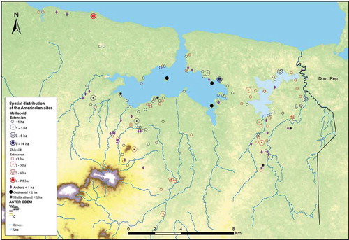
Figure 4. Affiliations of Amerindian ceramics in Haiti: (a), (b) and (c) Ostionoid; (d), (e), (f), (g) and h) Meillacoid; (i), (j), (k) and (l) Chicoid
Settlements with Meillacoid and Chicoid cultural components dominate the Amerindian landscape until Spanish colonial time (). The variation in site-sizes (i.e. from <1 ha to 14 ha) suggests a complexity of settlement distribution (Herrera Malatesta, Citation2018), which may explain the diverse social, economic, and symbolic activities. They may have had different purposes all along their settlement dynamics. The coastal area, in particular, expresses this pattern, with the largest settlements of both cultural components being located close to the coast. However, considering that some large settlements developed several kilometres further inland, they may also have played an important role in the establishment of large-scale settlements.
Changing demographic dynamics and socio-cultural transformations are traceable in the archaeological record up to the eve of Spanish colonisation. For instance, Meillacoid ceramics retain or reuse certain Archaic Age designs, which suggests an interaction with and integration of Archaic Age elements into later ceramic decorations and persistent reoccupations of the area (Keegan, Citation2006; Rouse, Citation1992). At Fort Liberté, Ostionoid ceramic sites were mainly found on small islands within the bay. Ceramic sites culturally affiliated with Meillacoid and Chicoid styles are predominant in the broader regional context, as well as at Fort-Liberté. We can observe grouped and aligned coastal sites that contain the same or different types of ceramics. Many sites were located close to semi-humid sectors near rivers and lagoons which gave direct access to natural resources but were also documented in areas currently without access to freshwater. The results of the investigations show that Meillacoid sites represent the largest number of Amerindian settlements at Fort-Liberté. Some sites contain both Meillacoid and Chicoid ceramics. These patterns of multicomponent ceramics in small and large settlements are common on the island (Herrera Malatesta, Citation2018; Hofman et al., Citation2018; Keegan, Citation2001; Koski-Karell, Citation2002; Moore & Tremmel, Citation1997; Ulloa Hung, Citation2014).
4.2. Dynamics of the colonial landscape
The knowledge of Haiti’s colonial period gained from archaeological research is minimal. Most research has been focussed on En Bas Saline, considered as the La Navidad location, and Puerto Real (e.g. Deagan, Citation1987, Citation1995; Ewen, Citation1992; LeFebvre, Citation2015; Newsom, Citation1995; Reitz, Citation1986; Williams, Citation1986), which is 30 km to the west of the region that is the subject of this study, and Bayahá (Hamilton & Hodges, Citation1995). As the earliest known colonial footprints in northern Haiti, those regions are crucial for the understanding of the colonial landscape dynamics through time.
The colonial town of Puerto Real, founded in 1503, is situated about 3 km from the sea on a vast alluvial plain. The archaeological map of northern Haiti shows this town to be close to a large number of indigenous settlements (Jean, Citation2019, p. 157). The Amerindian dwellers of those settlements may have been forced to work at Puerto Real during the Spanish colonial time (Deive, Citation1989). Analysis of archaeological material such as ceramic production techniques suggests contact among Amerindians, Europeans, and Africans at Puerto Real (G. G. Smith, Citation1995), that was generated from cultural ethnogenesis on the island (Deagan, Citation1995). However, other activities may have occurred over a more extensive area, e.g. the use of the alluvial plain for cattle ranching as a part of the Spanish economy. As a result of illegal smuggling activities in the north, Spanish authorities forced Puerto Real’s inhabitants to relocate to Bayaha (1578–1605), a new town founded 10 km inland from the coast which was near a river on a small semi-humid plateau (Hamilton & Hodges, Citation1995; Jean, Citation2019).
Only one archaeological excavation has been conducted (in early 1980) to find Bayaha (Hamilton & Hodges, Citation1995). The investigation revealed that the Spanish colonial settlement of Bayaha reused areas already chosen by Amerindian communities. For instance, faunal remains such as pig bones were found in an archaeological context associated with Amerindian ceramics, suggesting that the Indigenous communities had incorporated European animals into their diet before the Spanish founded Bayaha (Hamilton & Hodges, Citation1995). This indicates that some Amerindian activities probably continued during the massive displacement of the Indigenous populations to the colonial towns during the early stage of Spanish colonisation.
The depopulated Spanish towns in the northern part of Haiti may have served as starting points for French settlers in 1605. These former Spanish places were remodelled during the centuries that followed (Oexmelin, Citation1688). For instance, French colonists founded the Bourg de Bayaha in the vicinity of its Spanish namesake and used it as an administrative centre during the development of the plantations. From 1714 onwards, many sugar plantations were established in the Bayaha region and it became the major production centre of indigo in northern Haiti (Moreau de Saint-mery, Citation1797, p. 114). Two decades later, additional sugar plantations (Saint-Louis, Citation2004) and military bases were established and the administrative centre was moved from Bourg de Bayaha to the newly founded city of Fort-Dauphin (now Fort-Liberté) on the coast.
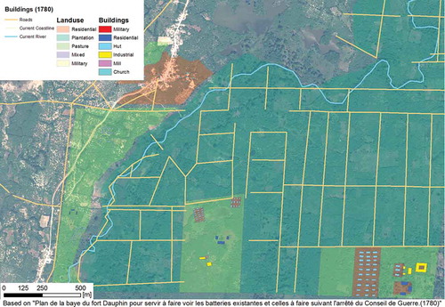
The most recent field-walking archaeological survey revealed how the French colonists used this region in the seventeenth and eighteenth centuries (Jean, Citation2019). Alluvial plains along the rivers and lagoons were crucial for growing sugarcane, sugarcane plantations occupied those areas, while dry sectors were reserved for indigo planting. An evolution of farm practices focussed on land exploitation and the founding of new individual settlements overwrote most of the Spanish colonial patterns at Fort-Liberté. Rivers were a crucial resource for irrigation, particularly for the sugar plantations. The detailed historical maps show at micro-scale the spatial organisation of the plantations’ ownership, pastures, and industrial and residential buildings in colonial Maribaroux Plaine, Fort-Liberté (). Based on data from Digital Globe Foundation, a combination of high resolution multispectral remote sensing data sets of WorldView2 and aerial images by Centre Nationale de l'Information Géo-Spatiale (CNIGS), were compared with the French historical maps in a GIS approach to visualise and interpret the change in land use. The modern satellite data show that many traces of the past are erased by land use, soil erosion, and modern expansion of villages and towns. Compared to the intensive agrarian system which determined the area in the past, the region today appears sparsely used and barren. Nevertheless, a number of hedges displayed in the historical maps, once separating and delimiting plantations, still exist today as living evidence of previous land ownership ().
Figure 5. Sugar plantations in the humid plains in the region of Fort-Liberté showing the location of buildings, gardens, and rivers
Based on archaeological survey results, shows the distribution of colonial archaeological traces, associated with plantations, colonial houses, mills, small bridges, and military bases along the coast and across the hinterlands. In this colonial context, they represent a new repertoire of material culture that shows this fundamental characteristic of the multi-layered aspects of Fort-Liberté’s landscape transformation. These historic features, as the materiality of the colonial phases, relate to multiple authors (colonists and enslaved Africans) who influenced the landscape’s paths in the seventeenth and eighteenth centuries.
Figure 6. Distribution of different colonial traces in the region
New incoming groups of people change the social demography. The transfer of plants and animals, new values, mentalities, and ideologies (Casid, Citation2005) may bring in new technologies that impact the process of landscape change that is visible in the change of material culture. Sometimes these elements explain superimposed layers of activities (Bailey, Citation2007) as is evident from one survey site characterised by coexisting Amerindian and colonial remains at some places at Fort-Liberté (). Another observation is related to the French colonial sites that reveal various objects of material cultures from France and other European countries used by the elite households (). ) shows different types of colonial archaeological traces in the Fort-Liberté landscape today. These traces, including for example, the vestiges of industrial buildings, wells, and industrial colonial ceramics, represent the implementation of new technologies introduced by French colonists who developed new types of strategies based on an extensive exploitation of the landscape to maintain the colonial system.
Figure 7. Colonial and Amerindian archaeological deposits in the same place
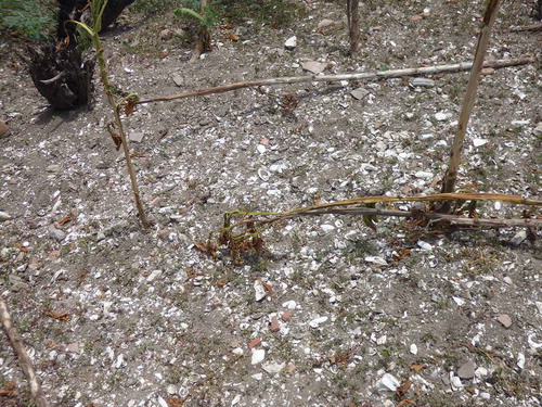
Figure 8. Different types of colonial sites (clockwise from top left): (a) vestiges of an industrial building; (b) wall of a military fortress; (c) water well; and (d) vestiges of industrial colonial ceramics
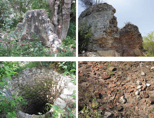
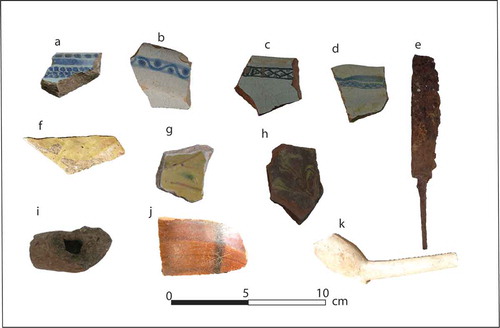
Figure 8. Different types of colonial material: (a) and (b) Faience blanche; (c) and (d) Faience brune; (e) colonial knife; (f) Biot (Jarre de Provence); (g) Cox; (h) Vallée de Huveaune; (i) local pipe; (j) Albisola; and (k) white pipe (seventeenth century)
4.3. Living archaeological sites
The material culture indicates that several indigenous and colonial archaeological sites were settled anew by the current population, tangibly demonstrating a long-term (re)occupation (Jean, Citation2019; Sonnemann & Jean, Citation2016). Some places in Fort-Liberté may have been resettled and reused by the freed people immediately after Haitian independence in 1804 and by others much later. Reoccupation of space and the continuity of use of the landscape can accelerate the process of erasure of previous human footprints and historical memory (Jean et al., Citation2020).
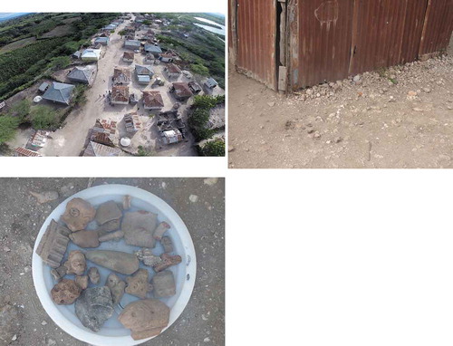
The modern village of Meillac ()) is situated on a plateau between a river and a lagoon and above one of the most significant Amerindian archaeological sites of Fort-Liberté that was re-occupied by colonists in the eighteenth century. The current occupants of the village built their homes on the archaeological site ()). However, there is no evidence of continuing occupation shortly after the Haitian revolution in 1804. Some inhabitants recognise the traces of the Amerindians who lived there before the European colonists. They raised this narrative of recognition after questions were asked about collections of archaeological finds. The primary importance of the archaeological objects is economic and not the preservation of the memory of the Amerindians. Some people appropriate these artefacts to sell them to heritage collectors ()). Other archaeological remains, like the colonial ruins in Haitian Creole regarded as ʺvye mazi, vye bout miray or vye bout miʺ (old hovels) (see also, Cauna, Citation2013), receive more interest from the local population than other sites, since it is easy to recognise them. To the name ʺvye miray blan fransè yoʺ (old French colonial vestiges) is attached such a strong pejorative implication that these colonial ruins can be destroyed without any compunction. The materials from the vestiges can be reused for house construction, since they are pejoratively considered as ʺancient thingsʺ (vye bagay ansyen).
Figure 9. Clockwise from top left: (a) Village built on an archaeological site; (b) House on top of archaeological materials; (c) Archaeological objects appropriated by individuals for selling
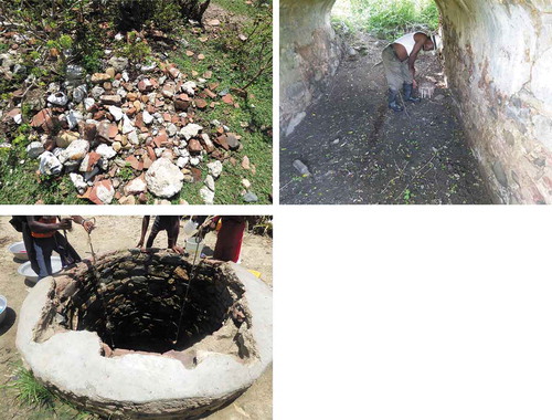
) shows this practice to be widespread at Fort-Liberté. However, some ruins are reused and protected by individuals who identify with them. Their significance is associated with their African ancestors who lived in these places, which results in the preservation of historical memory. Considered as a ʺspiritual resting placeʺ, they are then eritaj or eritay (heritage) and intended for devotional and religious practices. For instance, ) shows a man with a candle inside former storage where he usually performs religious rites. Thus, such colonial ruins are not merely evidence of the past, but also play essential roles in the present as an integrated relic of healing. The reuse of a relic can make it a part of the daily life of a community which gives it a new and different meaning. Archaeological remains can be just as useful in the present ()), in that they can be linked to different values depending on the social context and how they are re-appropriated. Communities thus decide what to preserve or destroy (L. Smith, Citation2006).
Figure 10. Clockwise from top left: (a) Destruction of archaeological ruins; (b) A man undertaking religious activities in a colonial ruin; (c) Community members taking water from a colonial well
5. Biography of a complex palimpsest landscape
The Fort-Liberté landscape experienced successive events with symbolic, economic, social, and political impacts. This region has a long history that stretches from Amerindian settlements through European colonisation to the post-colonial period, which is linked to various meanings and human interactions with the environment. The multi-layered imprint of diverse cultural groups shows their engagement with the physical environment that created a complex palimpsest landscape. Its biography implies reuse, rearrangement, and reorganisation of space through time (Kolen & Renes, Citation2015; Roymans et al., Citation2009). In our context, it shows a long history of the Amerindian organisation which began to decline from 1492, and also how it was significantly metamorphosed by moments of struggle during the colonial period through a radical change to a culture marked by the relationship between coloniser and colonised/enslaved people, and among European colonisers themselves.
5.1. Amerindian landscape organisation
The biography of landscape reminds us that Amerindian social and economic development at Fort-Liberté started with small-scale human activities. The earliest remains of Amerindian settlements suggest that the Archaic period spanned over 3000 years before large-scale pottery sites developed in the area. Considering the small number of Archaic Age sites, the first settlers seem to have had a limited impact on the landscape. Few activity areas at Fort-Liberté possibly existed over a long period based on subsistence economies. The social dynamics are highlighted by the specific materials collected. The growth of the Amerindian population that began from around 600 AD and lasted into the early colonial period was spread over a large number of settlements. Through the understanding of this landscape organisation, Ostionoid pottery sites are documented at three small sites on the islands in the Fort-Liberté bay, while Meillacoid and Chicoid pottery sites constituted the main settlement configuration in the region on the eve of the European invasion. The site distribution at this micro-regional scale may indicate negotiations of space by individuals and communities, as settlement patterns display similarities and differences in occupation strategies. For instance, areas along the coastline exhibit intensive Meillacoid and Chicoid pottery sites while, in some areas, Meillacoid pottery is predominant.
Understanding this episode in the Amerindian archaeological settlements at Fort-Liberté has clarified how indigenous communities created a landscape by engaging with this micro-geographic area. Their manifestations in this micro-region demonstrate traces of grouped settlements that contain either one or two types of pottery. These traces of activities across Fort-Liberté thus question the idea of Amerindian villages being usually conceptualised as single sites. The analysis of these Amerindian settlements leaves an excellent opportunity to deconstruct the differentiation of small, medium and large villages based conventionally only on single-site settlements (Koski-Karell, Citation2002). Isolated or grouped and aligned sites classified by the same or different cultural components can be considered as single Amerindian settlements dedicated to a community. All of the grouped sites can be conceptualised as villages based on kinship, where political and social dimensions played an important role (Torres, Citation2010). This picture can also be linked to micro-scale settlements of communities affiliated by shared social experiences, which created social organisations based on social dynamics within different communities in the region.
The Fort-Liberté region demonstrates that complex social organisations of precolonial Amerindian populations cannot be restricted to a single cultural component associated with a particular type of pottery (Rouse, Citation1992). However, the non-linear temporality of settlement sites that shows evidence of the two types of pottery that emerged at the same time cannot be ignored. The empirical evidence of Amerindian occupation and the spatial character of their settlement strategies, encompassed in their daily life and social practices of diverse communities in the region at the eve of Spanish colonisation (Herrera Malatesta, Citation2018), indicates a complex social organisation during this particular moment in the region’s historical development.
5.2. Colonial landscape (re)organisation
The colonial transformation of the landscape is characterised by the erasure of the indigenous landscape organisation and integration of European values. For example, the European reorganisation started with the change of indigenous toponyms (Dunn & Kelly, Citation1989; Morison, Citation1940). Columbus described Amerindian communities and their environment and replaced their indigenous names with European names to legitimise the Spanish appropriation of the island. Similar legitimisation was sought with symbolic and political strategies by the founding of Puerto Real and Bayaha. While the Amerindian impact on the environment was limited (Castilla-Beltrán et al., Citation2018), the reorganisation of ancient Amerindian landscapes through colonial land-grabbing imposed new political, ecological, and economic dynamics upon those landscapes. Reorganisation of the landscape led to the accumulation of new values, material culture, infrastructure, goods, natural and animal species, and peoples. For this reason, the colonial period of Fort-Liberté carries diverse biographies of multiple groups shaping the landscape through time. In this context, we must be aware that the old traces can be deliberately obliterated or reused by other people. At Fort-Liberté, places alongside the coast and inland have been abandoned and reoccupied through the centuries. The reshaping process of the colonial landscape then enabled the complex interplay between the Spaniards and French colonists to control the region. Intensive and extensive dimensions of this reshaping took place under French rule that reused Spanish sectors to establish themselves. Yet, each social context is vital for understanding different meanings of economic, social, and ecological manifestations of the landscape over time. Economic manifestations can be seen through the implementation of the colonial infrastructure that encompasses buildings, machines, and roads. Further, new agricultural methods and techniques affected not only the landscape of Fort-Liberté but also established new values and perceptions of lands and people, for example, the materiality of power to protect the colonial territory and condition of the enslaved people as property to maintain the system.
The spatial distribution of colonial remains at Fort-Liberté shows that the French used the lands by exploiting environmental features such as rivers, lagoons, dry and humid zones, and coastal and hinterlands, as sectors for different purposes. We can see the aim of this exploitation to be an accumulation of economic, symbolic, and social power that ensured the French colonists could create colonial urban and rural landscapes with the movement of plants, animals, and people. This radical change imposed new ecological dynamics and caused a significant impact on the natural environment through activities such as the felling of trees and the use of river waters for establishing plantations. Through the ʺhybrid landscapeʺ (Casid, Citation2005), French colonial plantations became the central element in the economic and social configuration of the European colonial era. Natural and topographic conditions of Fort-Liberté made sugar and indigo the essential indicators of the process of landscape change in association with the massive enslavement of Africans for working on the plantations (e.g. Garrigus, Citation1993; Geggus, Citation1999). These are the fundamental elements that provoked the profound economic, social, and political change in the region’s history (Fick, Citation1990) and constructed new stories in the colonial landscape. As Reinaldo Funes (Citation2008) has shown in the case of Cuba, the sugar industry caused long-term social and environmental impacts, which remain visible through soil and forest deterioration today. However, through the spatial organisation necessitated by the exploitation of Fort-Liberté, extensive land-use may also have provoked environmental change and changed the ecological dynamics of the landscape. As a symbol of the ‘development of capitalist production’ (Mintz, Citation1985), the plantation reflects the core of the spatial landscape configuration at Fort-Liberté through which the colonists created boundaries between plantations of different private ownership. Each estate can be considered as a micro-landscape where lands, environmental variables, and enslaved Africans became exploitable colonial properties sustained by laws and regulations, constituting the institutionalisation of the process of changing the landscape (Jean, Citation2019). This colonial pattern sheds light on the rural landscape’s organisation in which interconnected military forts, ports, and towns constituted the communication network that facilitated the movement of goods, animals, and people.
The physical material is important for this landscape biography. It helps us in tracking different human paths. Therefore, we highlight here the vestiges of military forts, ruins of colonial and industrial houses, and the remains of movable objects found in Fort-Liberté which show the French colonial project to be rooted in complex relations between humans and the construction of landscape. The materials related to the colonial context cannot be understood without taking into account the daily life of Africans on the plantations. Their enslavement not only maintained the colonial economy but also fed the resistance to the colonial system and the rejection of the colonial order (Casimir, Citation2020). Today, archaeological objects from this colonial era across the region do not merely represent the exploitation of its environment and people, but also a landscape of resistance—ʺcounter colonial landscapesʺ (Casid, Citation2005) where the enslaved people struggled to survive and break out of the colonial domination in the eighteenth century (Casimir, Citation2020). These people began a long-lasting resistance in the context of ʺtransculturalʺ experience (Ortiz, Citation1970) that caused a social, economic, and political rupture in Haiti in the eighteenth century (Dubois, Citation2004; Geggus, Citation2012; Hurbon, Citation2000).
The struggle between the Spanish and French to gain control of the lands obliterated most of the Spanish imprints in the Fort-Liberté’s landscape. By contrast, there are numerous ruined structures associated with the French plantations. It is characteristic of a palimpsest landscape that colonial dynamics erase, render silent, accumulate, and overlap stories of different peoples. Spanish and French rules intermingled in time. Archaeological practices create paths to interpret the past objects of the Spanish period hidden in the Fort-Liberté soil and bring stories to capture this specific time in the present. The colonial landscape of Fort-Liberté is complex and crowded with multiple imprints. The visibility of the colonial ruins suppresses the movable materials that may be directly attributable to the households of enslaved people. The study of ancient plantations in Haiti should focus on the silenced heritage of the ʺenslaved Africans who created a sovereign societyʺ (Casimir, Citation2020) and the continuing interactions that the current communities have developed with the related material past (Jean et al., Citation2020).
5.3. The archaeological heritage today
We outlined the different cultural groups that created Fort-Liberté’s landscape over time, up to the end of the colonial period. Beyond archaeological interpretations and understanding, it is necessary to highlight the role of archaeological features in present-day society. These features are an essential element in the biographical approach to landscape, either through their meaning for individuals or through heritage practices that encompass local government politics. The biographical approach sees archaeological material not separated from individuals and communities. Archaeological objects can be impacted by individuals and cultural groups, which affect human understanding at each point in time. They can interweave with the present in many ways, which affects the social perception and sense of cultural appropriation (Bradley, Citation2002; Holtorf & Williams, Citation2006; Olivier, Citation2011; L. Smith, Citation2006). In terms of social significance, more attention is attracted by colonial ruins than by Amerindian materials at Fort-Liberté. This may be because the colonial past is more recent than the history of Amerindians in Haiti which has, for long, been suppressed by the society in general. Also, colonial features are more visible in the landscape. We found that individuals reuse, destroy, protect, and re-appropriate them for different purposes and intentions. Colonial vestiges (vye mazi/ancient things) can be claimed by individuals when they are found on their land. However, that is not generally related to a personal attachment leading to protection for them as heritage, but rather to the reuse of some elements such as bricks and rocks for personal purposes, leading to their total erasure. On the other hand, we observed that some individuals create an affiliation with the ruins, an intangible aspect that results in their preservation. The pattern of reuse corresponds with religious practices for which these sites are used. Given the recognition as historical elements of the slavery of their ancestors, revisiting the colonial ruins for religious rites refers to the memory of the enslaved ancestors. They are also associated with other social meanings in the current landscape, for tackling the complex and non-linear temporalities of the colonial vestiges symbolising the collapse of the imperial system.
In the present context, archaeological research cannot only focus on collecting narratives of the past from chronology or object technology. To develop strategies for the future of the archaeological heritage, it becomes necessary to consider the current narratives of individuals and communities who interact with the sites today.
However, in terms of heritage practices, great challenges persist (Jean et al., Citation2020). The regional administrative centres do not have a heritage database of the locations of the ancient settlements. There are no local museums, educational programme, or associations to play an active role in meeting the challenges about the future of Fort-Liberté’s heritage. Neglected by the local government in the context of land management and the planning budget, there is no clear strategy for the protection and preservation of this heritage. This issue poses another challenge to translating the various values attaching to heritage into sustained practices that can set the foundation for securing the present Fort-Liberté archaeological sites against loss (Jean et al., Citation2020).
Archaeological sites at Fort-Liberté face obliteration by the rapid expansion of modern villages, expansion of land management practices, and a growing threat from natural hazards. These common phenomena can deprive us of an understanding of past human footsteps in the landscape. Oral traditions and local narratives associated with the specific sites contribute to their preservation. However, local government, institutional authorities, educational institutions, and members of communities need to work on developing strategies to protect these sites as landmarks in the history of Haitian development (Jean et al., Citation2020). The representation of the past in the Haitian post-colonial context should give voice to the deep historical past by using strategies and practices to perpetuate the heritage, so that the violence that marked the colonial times, which is shadowed in the society, is not forgotten (Trouillot, Citation1994).
6. Concluding note
The landscape biography of the Fort-Liberté region is marked by a long period. This biography is reflected in and defined by successive layers that characterised the landscape at various times; by erasure and accumulations of diverse footprints, these multiple histories with remarkable archaeological features make the Fort-Liberté case a particular story within the larger regional history. Fort-Liberté’s geographic location and natural settings play an important role in its landscape dynamic that is marked by numerous traces of various stages of Amerindian activity and vestiges of colonial past, such as the remains of plantations and military ruins. Landscape biography, besides studying different historical layers, opens important possibilities for looking at this region through the lens of its heritage management and planning. This is important to rescue its heritage from oblivion because land management and development projects are being implemented in the region.
We took on board the early human strategies in this micro-region and found that the complex indigenous cultural landscape is a manifestation of a long process of human-environment interactions since about 3000 BC. Ecological variables associated with economic and symbolic activities may have contributed significantly to the creation of this Amerindian landscape. Other factors, such as negotiation of places and exchange networks, may have been crucial for identity formation. Their settlement strategies across the region of this study (grouped and isolated) and the circulation of material culture among the communities might have played an important role in the process of social organisation which later was deeply impacted by the European footprints. This history involves two different strategies in the process of colonial transformations of the region’s landscape. Even though farming and cattle ranching remained an important part of the Spanish economy, the implementation of Spanish colonial strategies was generally aimed at creating urban landscapes, but these could not develop because of the continuous illegal trade that weakened their economy. In contrast, the French colonists capitalised on extensive industrial plantations and the use of enslaved African labour was the key factor in the development of Fort-Liberté’s profitable rural landscape of indigo and sugar plantations. In summary, many individuals and communities were involved in the long process of reshaping the landscape, which left indigenous and colonial archaeological traces that are socially significant; however, they represent a heritage that is either being re-appropriated or remains neglected today.
Acknowledgments
We acknowledge the Digital Globe Foundation and Centre Nationale de l'Information Géo-Spatiale (CNIGS). Special thanks go to communities of the Fort-Liberté region for their help during this survey and Mr. Erol Josué (director of the Bureau National d’Ethnologie, Haiti) for providing administrative assistance during this fieldwork. Editorial help and valuable comments were provided by Ian Lilley, Andy Ciofalo, Simone Casale, and Emmade Mooij. Also, we would like to acknowledge the insightful comments of the anonymous reviewers.
Disclosure statement
No potential conflict of interest was reported by the authors.
Additional information
Funding
Notes on contributors
Joseph Sony Jean
Joseph Sony Jean is a Post-doctoral Researcher at KITLV within the CaribTRAILS project. His work focuses on Haiti's long-term landscape transformations by using data from ethnography, ethnohistory, and archaeological records. He is interested in heritage studies, particularly the politics of heritage and relationships between contemporary societies and heritage.
Till Sonnemann
Till Sonnemann is Junior Professor for Digital Geoarchaeology (IVGA) at Bamberg University in Germany. His research and teaching interest is to improve the analysis and protection of archaeological and natural heritage by non-destructive and digital means.
Corinne L. Hofman
Corinne L. Hofman is Professor of Caribbean Archaeology at the Faculty of Archaeology, Leiden University. She is currently PI of the CaribTRAILS project at the KITLV, which receives funding from the NWO Spinoza prize awarded to her in 2014. From 2013 to 2019, Prof. Hofman was the CPI of the ERC-Synergy project NEXUS1492.
References
- Bailey, G. (2007). Time perspectives, palimpsests and the archaeology of time. Journal of Anthropological Archaeology, 26(2), 198–223. https://doi.org/10.1016/j.jaa.2006.08.002
- Bain, A., Faucher, A. M., Kennedy, L. M., LeBlanc, A. R., Burn, M. J., Boger, R., & Perdikaris, S. (2018). Landscape transformation during ceramic age and colonial occupations of Barbuda, West Indies. Environmental Archaeology, 23(1), 36–46. https://doi.org/10.1080/14614103.2017.1345115
- Bannister, M. E., & Nair, P. K. R. (2003). Agroforestry adoption in Haiti: The importance of household and farm characteristics. Agroforestry Systems, 57(2), 149–157. https://doi.org/10.1023/A:1023973623247
- Bellande, A. (2009). Impact Socioeconomique de la dégradation des terres en Haïti et interventions pour la réhabilitation du milieu cultivé. Comisión Económica para América Latina y el Caribe (CEPAL). (pp. 1–73). https://repositorio.cepal.org/bitstream/handle/11362/3740/S2009235_fr.pdf?sequence=1&isAllowed=y
- Bloemers, J. H. F., Kars, H., & Valk, A. V. D. (Eds.). (2010). The cultural landscape & heritage paradox: Protection and development of the Dutch archaeological-historical landscape and its European dimension. Amsterdam University Press.
- Bradley, R. (2002). The past in prehistoric societies. Routledge.
- Burnard, T., & Garrigus, J. (2016). The plantation machine: Atlantic capitalism in French Saint-Domingue and British Jamaica. University of Pennsylvania Press.
- Casid, J. H. (2005). Sowing empire: Landscape and colonization. University of Minnesota Press.
- Casimir, J. (2020). The Haitians: A decolonial history. University of North Carolina Press.
- Castilla-Beltrán, A., Hooghiemstra, H., Hoogland, M. L. P., Donders, T. H., Pagán-Jiménez, J. R., McMichael, C. H., … Hofman, C. L. (2020). Ecological responses to land use change in the face of European colonization of Haytí island. Quaternary Science Reviews, 241(1), 106407. https://doi.org/10.1016/j.quascirev.2020.106407
- Castilla-Beltrán, A., Hooghiemstra, H., Hoogland, M. L. P., Pagán-Jiménez, J., van Geel, B., Field, M. H., … McMichael, C. H. (2018). Columbus’ footprint in Hispaniola: A paleoenvironmental record of indigenous and colonial impacts on the landscape of the central Cibao Valley, northern Dominican Republic. Anthropocene, 22(2018), 66–80. https://doi.org/10.1016/j.ancene.2018.05.003
- Cauna, J. (2003). Au temps des isles à sucre: Histoire d’une plantation de Saint-Domingue au XVIIIe siècle. Karthala.
- Cauna, J. D. (2013). Patrimoine et mémoire de l’esclavage en Haïti: Les vestiges de la société d’habitation coloniale. In Situ, (20). https://doi.org/10.4000/insitu.10107
- Churches, C. E., Wampler, P. J., Sun, W., & Smith, A. J. (2014). Evaluation of forest cover estimates for Haiti using supervised classification of Landsat data. International Journal of Applied Earth Observation and Geoinformation, 30(2014), 203–216. https://doi.org/10.1016/j.jag.2014.01.020
- D’Ans, A. M. (1987). Haiti: Paysage et société. Karthala.
- Deagan, K. A. (1987). Initial encounters: Arawak responses to European contact at the En Bas Saline site, Haiti. In D. T. Gerace (Ed.) Proceedings of the First San Salvador Conference (pp. 341–359). College Center of the Finger Lakes, Gerace Research Center, San Salvador, The Bahamas.
- Deagan, K. A. (Ed.) (1995). Puerto Real: The archaeology of a sixteenth-century Spanish town in Hispaniola. University Press of Florida.
- Deive, C. E. (1989). Los guerrilleros negros: Esclavos fugitivos y cimarrones en Santo Domingo. Fundacion cultural dominicana.
- Dolisca, F., Mcdaniel, J., Teeter, L. D., & Jolly, C. M. (2007). Land tenure, population pressure, and deforestation in Haiti: The case of Forêt des Pins Reserve. Journal of Economics, 13(4), 277–289.
- Dubois, L. (2004). Avengers of the new world. Harvard University Press.
- Dunn, O., & Kelly, J. E. (1989). The diario of Christopher Columbus’ first voyage to America 1492-93. University of Oklahoma Press.
- Ewen, C. (1992). From Spaniard to Creole: The archaeology of culture formation at Puerto Real. Haiti. University of Alabama Press.
- Fick, C. E. (1990). The making of Haiti: The Saint Domingue revolution from below. University of Tennessee Press.
- Funes, M. R. (2008). From rainforest to cane field in Cuba: An environmental history since 1492. University of North Carolina Press.
- Garrigus, J. (1993). Blue and brown: Contraband indigo and the rise of a free colored planter class in French Saint-Domingue. The Americas, 50(2), 233–263. https://doi.org/10.2307/1007140
- Geggus, D. P. (1999). Slave society in the sugar plantation zones of Saint Domingue and the revolution of 1791–93. Slavery & Abolition, 20(2), 31–46. https://doi.org/10.1080/01440399908575276
- Geggus, D. P. (2012). Saint-Domingue on the eve of the Haitian revolution. In Sepinwall, A. (Ed.), Haitian history (pp. 82–98). Routledge.
- Hamilton, J. M., & Hodges, W. H. (1995). The aftermath of puerto real: Archaeology at Bayaha. In K. A. Deagan (Ed.), Puerto real. The archaeology of a sixteenth-century Spanish town in Hispaniola (pp. 377–418). University Presses of Florida.
- Herrera Malatesta, E. N. (2018). Una Isla, dos mundos: Estudio arqueológico sobre el paisaje indígena de Haytí y su transformación al paisaje colonial de La Española (1200-1550). Sidestone Press.
- Higuera-Gundy, A., Brenner, M., Hodell, D. A., Curtis, J. H., Leyden, B. W., & Binford, M. W. (1999). A 10,300 14C yr record of climate and vegetation change from Haiti. Quaternary Research, 52(2), 159–170. https://doi.org/10.1006/qres.1999.2062
- Hofman, C., Valcárcel Rojas, R., & Ulloa Hung, J. (2020). Colonization, transformations, and indigenous cultural persistence in the Caribbean. In C. Beaule & J. Douglass (Eds.), The global Spanish empire: Five hundred years of place making and pluralism (pp. 55–82). University of Arizona Press.
- Hofman, C. L., & Antczak, A. T. (Eds.). (2019). Early settlers of the insular Caribbean: Dearchaizing the Archaic. Sidestone Press.
- Hofman, C. L., Borck, L., Laffoon, J. E., Slayton, E. R., Scott, R. B., Breukel, T. W., Guzzo Falci, C., & Hoogland, M. L. P. (2020). Island networks: Transformations of inter-community social relationships in the Lesser Antilles at the advent of European colonialism. The Journal of Island and Coastal Archaeology, 1–27. https://doi.org/10.1080/15564894.2020.1748770
- Hofman, C. L., & Keehnen, F. W. M. (Eds.). (2019). Material encounters and indigenous transformations in the early colonial Americas: Archaeological case studies. Brill.
- Hofman, C. L., Ulloa Hung, J., Herrera Malatesta, E., Jean, J. S., Sonnemann, T., & Hoogland, M. L. P. (2018). Indigenous Caribbean perspectives: Archaeologies and legacies of the first colonised region in the new world. Antiquity, 92(361), 200–216. https://doi.org/10.15184/aqy.2017.247
- Holtorf, C., & Williams, H. (2006). Landscapes and memories. In D. Hicks & M. C. Beaudry (Eds.), The Cambridge companion to historical archaeology (pp. 235–254). Cambridge University Press.
- Hurbon, L. (Ed.). (2000). L’insurrection des esclaves de Saint-Domingue, 22-23 août 1791: Actes de la table ronde internationale de Port-au-Prince, 8 au 10 décembre 1997. Karthala Editions.
- Ingold, T. (2000). The perception of the environment: Essays on livelihood, dwelling and skill. Psychology Press.
- Jean, J. S. (2019). La biographie d’un paysage. Etude sur les transformations de longue durée du paysage culturel de la région de Fort-Liberté, Haïti. Sidestone Press.
- Jean, J. S., Joseph, M., Louis, C., & Michel, J. (2020). Haitian archaeological heritage: Understanding its loss and paths to future preservation. Heritage, 3(3), 733–752. https://doi.org/10.3390/heritage3030041
- Jean-Denis, S., Jean-Pierre, D., Mutel, M., Duchaufour, H., Langlais, C., Fernandes, P., & Malézieux, É. (2014). Changes in the structure of agroforestry systems according to family life cycles: The example of home gardens in Haiti. Bois et Forets Des Tropiques, 321(321), 7–20. https://doi.org/10.19182/bft2014.321.a31213
- Keegan, W. F. (2001). Archaeological investigations on He á Rat, Haiti: Avoid the oid. In G. Richard (Ed.), Proceedings of the XVIII International Congress for Caribbean Archaeology (pp. 233–239). IACA. St George's University Campus, St George, Grenada.
- Keegan, W. F. (2006). Archaic influences in the origins and development of Taino societies. Caribbean Journal of Science, 42(1), 1.
- Kimber, C. T. (1988). Martinique revisited: The changing plant geographies of a West Indian island. Texas A&M University Press.
- Kolen, J., & Renes, J. (2015). Landscape biographies: Key issues. In J. Renes, R. Hermans, & J. Kolen (Eds.), Landscape biographies: Geographical, historical and archaeological perspectives (pp. 21–43). Amsterdam University Press.
- Kolen, J., Renes, J., & Hermans, R. (Eds.). (2015). Landscape biographies: Geographical, historical and archaeological perspectives on the production and transmission of landscapes. Amsterdam University Press.
- Koski-Karell, D. A. (2002). Prehistoric northern Haiti: Settlement in diachronic ecological context. [Unpublished doctoral dissertation]. Catholic University of America
- Kramer, P., Atis, M., Schill, S., Williams, S. M., Freid, E., Moore, G., … Grizzle, R. (2016). Baseline ecological inventory for Three Bays National Park, Haiti. The Nature Conservancy: Report to the Inter-American Development Bank.
- LeFebvre, M. J. (2015). Animals, food, and social life among the pre-Columbian taíno of En Bas Saline, Hispaniola [Unpublished Doctoral dissertation]. University of Florida.
- Lindskog, P. (1998). From Saint Domingue to Haiti: Some consequences of European colonization on the physical environment of Hispaniola. Caribbean Geography, 9(2), 71. https://search.proquest.com/docview/232108976?pq-origsite=gscholar&fromopenview=true
- Ménanteau, L., & Vanney, J. R. (Eds.). (1997). Atlas côtier du Nord-Est d’Haïti: Environnement et patrimoine culturel de la Région de Fort-Liberté. Ministère de la Culture.
- Mintz, S. W. (1985). Sweetness and power: The place of sugar in modern history. Viking.
- Moore, C. (1992). Les ateliers lithiques en Haiti. Bulletin du Bureau National d'Ethnologie, Numéro Spécial (1987–1992), (pp. 13–30).
- Moore, C., & Tremmel, N. (1997). Settlement patterns in pre-Columbian Haiti: An inventory of archaeological sites. Bureau National d’Ethnologie.
- Moreau de Saint-mery, M. D. R. L. E. (1797). Description topographique, physique, civile, politique et historique de la partie francaise de l’isle Saint-Domingue (Tome. 1). Chez L'auteur.
- Morison, S. E. (1940). The Route of Columbus along the North Coast of Haiti, and the site of Navidad. Transactions of the American Philosophical Society, 31(4), i–285. https://doi.org/10.2307/1005582
- Newsom, L. A. (1995). Mangroves and root crops: The archaeobotanical record from En Bas Saline, Haïti. In G. Richard (Ed.) Proceedings of the Sixteenth International Congress for Caribbean Archaeology (pp. 52–66). Basse Terre, Guadeloupe.
- Oexmelin, A.-O. (1688). Histoire des aventuriers flibustiers qui se sont signalés dans les Indes avec la vie, les mœurs, les coutumes des habitants de Saint-Domingue. Jacques LeFebure.
- Olivier, L. (2011). Temps des vestiges et mémoire du passé: à propos des traces, empreintes et autres palimpsestes. Le Genre humain, 1(1), 309–326. https://doi.org/10.3917/lgh.050.0309
- Ortiz, F. (1970). Cuban counterpoint: Tobacco and sugar. Translated by Harriet de Onis. Vintage Books.
- Pagan-Jimenez, J. R. (2011). Early phytocultural processes in the pre-Colonial Antilles. In C. L. Hofman & A. van Duijvenbode (Eds.), Communities in contact: Essays in archaeology, ethnohistory of the Amerindian circum-Caribbean (pp. 87–116). Sidestone Press.
- Pagan-Jimenez, J. R. (2013). Human-plant dynamics in the precolonial Antilles: A synthetic update. In W. F. Keegan, C. L. Hofman, & R. Rodríguez Ramos (Eds.), The Oxford handbook of Caribbean archaeology (pp. 391–406). Oxford University Press.
- Pagan-Jimenez, J. R., Ali, Z., Santiago-Marrero, C. G., & Hofman, C. L. (2020). Plantscapes of dwelling: Precolonial household mounds, phytocultural dynamics and the ensuing human ecosystems at El Flaco and El Carril (cal. AD 990–1450), northern Dominican Republic. Review of Palaeobotany and Palynology, 274(2020), 104–160. https://doi.org/10.1016/j.revpalbo.2020.104160
- Palang, H., & Peil, T. (2010). Mapping future through the study of the past and present: Estonian suburbia. Futures, 42(7), 700–710. https://doi.org/10.1016/j.futures.2010.04.007
- Palang, H., Spek, T., & Stenseke, M. (2011). Digging in the past: New conceptual models in landscape history and their relevance in peri-urban landscapes. Landscape and Urban Planning, 100(4), 344–346. https://doi.org/10.1016/j.landurbplan.2011.01.012
- Papmehl-Dufay, L. (2015). Places that matter: Megalithic monuments from a biographical perspective. In J. Renes, R. Hermans, & J. Kolen (Eds.), Landscape biographies: geographical, historical and archaeological perspectives (pp. 143–165). Amsterdam University Press.
- Pollard, J., & Reynolds, A. J. (2002). Avebury: The biography of a landscape. Stroud. Publishing Ltd.
- Rainey, F. G. (1941). Excavations in the Ft. Liberté Region, Haiti (No. 23-24). Yale University Press.
- Reid, B. A. (Ed.) (2018). The archaeology of Caribbean and Circum-Caribbean farmers (6000 BC – AD 1500). Routlege.
- Reitz, E. (1986). Vertebrate Fauna from Locus 39, Puerto Real, Haiti. Journal of Field Archaeology, 13(3), 317–328. https://doi.org/10.2307/530119
- Rivera-Collazo, I. C. (2015). Por el camino verde: Long-term tropical socioecosystem dynamics and the Anthropocene as seen from Puerto Rico. The Holocene, 25(10), 1604–1611. https://doi.org/10.1177/0959683615588373
- Rivera-Collazo, I. C., Rodríguez-Franco, C., & Garay-Vázquez, J. J. (2018). A deep-time socioecosystem framework to understand social vulnerability on a tropical island. Environmental Archaeology, 23(1), 97–108. https://doi.org/10.1080/14614103.2017.1342397
- Rouse, I. (1939). Prehistory in Haiti: A study in method. Yale University Press.
- Rouse, I. (1941). Culture of the Ft. Liberté Region, Haiti. Yale University Press.
- Rouse, I. (1992). Tainos: Rise and decline of the people who greeted Columbus. Yale University Press.
- Roymans, N., Gerritsen, F., Van der Heijden, C., Bosma, K., & Kolen, J. (2009). Landscape biography as research strategy: The case of the South Netherlands project. Landscape Research, 34(3), 337–359. https://doi.org/10.1080/01426390802381185
- Saint-Louis, V. (2004). Le sucre et le peuplement d’Haïti. In Cahier des Anneaux de la Mémoire (Ed.), Haïti: Matière premières (Vol. 6, pp. 20–39). Anneaux de la mémoire.
- Samson, A. V., & Cooper, J. (2015). History on Mona Island: Long-term human and landscape dynamics of an ‘inhabited island. New West Indian Guide/Nieuwe West-Indische Gids, 89(1–2), 30–60. https://doi.org/10.1163/22134360-08901054
- Smith, G. (1995). Indians and Africans at Puerto Real: The ceramic evidence. In K. A. Deagan (Ed.), Puerto real: The archaeology of a sixteenth century town in Hispaniola (pp. 335–374). University Press of Florida.
- Smith, L. (2006). Uses of heritage. Routledge.
- Smith, L., & Waterton, E. (2009). Heritage, communities and archaeology. Duckworth.
- Sonnemann, T., & Jean, J. S.. (2016, May 27). Living on heritage: Amerindian presence in Haiti [Video]. Youtube. . https://www.youtube.com/watch?v=X-VIK6oLewk&t=4.
- Sprenkle-Hyppolite, S. D., Latimer, A. M., Young, T. P., & Rice, K. J. (2016). Landscape factors and restoration practices associated with initial reforestation success in Haiti. Ecological Restoration, 34(4), 306–316. https://doi.org/10.3368/er.34.4.306
- Sullivan, S., & Mackay, R. (Eds.). (2012). Archaeological sites: Conservation and management. Getty Conservation Institute.
- Tarter, A. M., Freeman, K. K., & Sander, K. (2016). A history of landscape-level land management efforts in Haiti: Lessons learned from case studies spanning eight decades. World Bank Group.
- Torres, J. M. (2010). Tibes and the social landscape: Integration, interaction and the community. In L. A. Curet & L. M. Stringer (Eds.), Tibes: People, power, and ritual at the center of the cosmos (pp. 231–260). University of Alabama Press.
- Trouillot, M. R. (1994). Culture, color, and politics in Haiti. In S. Gregory & R. Sanjek (Eds.), Race (pp. 146–174). Rutgers University Press.
- Ulloa Hung, J. (2014). Arqueologia en la linea noroeste de La Espanola: Paisajes, ceramicas e interacciones. Instituto Tecnológico de Santo Domingo.
- Versluis, A., & Rogan, J. (2010). Mapping land-cover change in a Haitian watershed using a combined spectral mixture analysis and classification tree procedure. Geocarto International, 25(2), 85–103. https://doi.org/10.1080/10106040902977584
- White, J., Shao, Y., Kennedy, L. M., & Campbell, J. B. (2013). Landscape Dynamics on the Island of La Gonave, Haiti, 1990–2010. Land, 2(3), 493–507. https://doi.org/10.3390/land2030493
- Williams, M. (1986). Sub-surface patterning at 16th century Spanish Puerto Real, Haiti. Journal of Field Archaeology, 13(3), 283–296. https://doi.org/10.2307/530116