
ABSTRACT
Wallington in central Northumberland is a late seventeenth- and early eighteenth-century country house with associated pleasure grounds. Much of the surrounding estate is agricultural land, though there are also expanses of moorland and conifer plantation. The character of Wallington’s landscape, now divided into fifteen separate farm holdings, was to a large extent shaped by estate management practices and improvements in the eighteenth– nineteenth centuries. Today’s settlement pattern is made up largely of dispersed farmsteads, with field systems which reflect the orderly rectilinear layout of planned enclosure, being separated mainly by long and fairly straight stonefaced banks. In medieval and early modern times, by contrast, the landscape is thought to have been quite different, with nucleated villages set amidst irregular open fields which were farmed collectively.
The process of long-term landscape change from open to enclosed field systems has been inferred across the whole of Northumberland but it can be difficult to understand in detail. Absolute dating evidence for field systems before the eighteenth century is generally lacking and the origins and development of historic earthworks including boundary banks and the remains of arable farming are poorly understood.
This paper presents results of research which used retrogressive landscape analysis (based on documentary evidence, archaeological data, aerial photographs, and historic cartography) to identify five areas for detailed geoarchaeological investigation and sampling with optically stimulated luminescence profiling and dating (OSL-PD). The results provide new perspectives on the development of landscape character at Wallington which have wider relevance for north-east England and beyond.
INTRODUCTION
Northumberland has been among the least densely inhabited counties of England since the later Middle Ages. Despite significant industrialisation in some areas from the seventeenth century onwards (for example the lower reaches of the rivers Blythe and Tyne), the character of the rural landscape has been shaped most profoundly by its farming history. Nevertheless, the earlier stages of the region’s agricultural history — in particular the development of field systems — remain quite poorly understood (Petts & Gerrard Citation2006, p. 215).
The county’s physical geography contributed to the emergence of three main historic agricultural regions by early modern times. In the western uplands the hills and moors were mainly exploited for cattle and sheep; arable cultivation associated with hamlets and isolated farms was limited in scale. By contrast the relatively fertile coastal lowlands in the east were dominated by an arable regime with many large nucleated villages. Between these two regions a mixed form of husbandry flourished on the midland plain of scarps, plateaux and vales; high moors offered extensive grazing which complemented the arable, meadow and pasture in the valleys and lower-lying plains (Butlin Citation1973, pp. 93–6; Thirsk Citation1967, pp. 21–8).
There seem to have been areas of common field, meadow and pasture in both the lowlands and the uplands before their widespread disappearance through enclosure. Piecemeal enclosure had begun during the medieval period, but for Northumberland it was particularly in the late sixteenth, seventeenth and early eighteenth centuries that enclosure of open fields by agreement proceeded at a rapid pace and succeeded in removing the old patterns of landholding within a fairly short period. Enclosure by private and general Acts of Parliament operated on a more limited scale from c. 1740 to 1850, and mostly affected pasture, moorland and fell (O’Donnell Citation2015, pp. 11–13).
When enclosure awards and/ or the accompanying maps have been preserved, they provide an important source of information on early field systems on the verge of transformation. Other valuable records of late and post-medieval arrangements are found in the maps, terriers, written surveys, rentals, and similar documents which relate to the estates of the principal landowners, dating mostly from the sixteenth to the eighteenth centuries (Tolan-Smith Citation1997). Looking further back in time, however, the antecedents of these field systems become very difficult to trace. This is partly because few maps were produced before 1500, but also because Northumberland has a particular dearth of the more important medieval documentary sources, which remain largely confined to charters, tax returns and inquisitions post mortem. The region is omitted from the Domesday Survey of 1086 because when it was commissioned the new Norman regime had only recently suppressed local resistance and had yet to undertake land redistribution. In the fourteenth century, Northumberland was also exempt from many Lay Subsidies because of continuing crossborder warfare with Scotland. There are relatively few surviving court rolls and manorial accounts, perhaps because many were destroyed during the fighting (Butlin Citation1973, pp. 8–28; Wrathmell Citation1975, pp. 22–4).
Analysis of field patterns, traces of cultivation and archaeological evidence has great potential to enhance our knowledge of ancient field systems. Much depends on the state of preservation of the field evidence, which has in turn influenced the quantity and quality of research in different areas. In the uplands, which are relatively marginal for modern agriculture, the earthworks of ancient field systems are frequently better preserved than in the more intensively exploited lowlands. Nevertheless, the North East Regional Research Framework for the Historic Environment stressed the need for much more fieldwork in both lowland and upland environments with the aim of recording field systems and, in particular, to address the frustrating lack of reliable dating evidence, with many field systems currently recorded simply as relative stratigraphic successions (Petts & Gerrard Citation2006, pp. 135–7, 157, 169–70, 178). Very little is known about the character of field systems in the early medieval period or their evolution into the later Middle Ages, but even the chronologies of presumed late and post-medieval features like ridge and furrow or enclosure boundaries are poorly understood. It seems likely that the distinctive landscape regions which still characterise the North-East have their roots in the medieval period, but the extent to which the remains of prehistoric, Roman and early medieval landscapes have influenced those of later periods is open to question. Investigating the possible long-term continuity of boundaries, dykes, lynchets, and other elements of Northumbrian field systems is therefore a priority for researchers.
The research presented in this paper forms part of a project whose overall aim was to assess the long-term development of historic character in contrasting rural landscapes in the United Kingdom and Belgium. The project aimed at determining the origins of landscape elements such as field boundaries and earthworks created through arable farming, examine how they developed over time, and understand how they have contributed to shaping landscapes in subsequent periods up to the present. This required the combination of a range of data sources commonly used in historical geography and landscape archaeology. Given the long-standing problems in understanding the chronology of ancient field systems, the project also employed an innovative technique to date the creation and development of earthwork field boundaries known as optically stimulated luminescence profiling and dating (OSL-PD) (Vervust et al. Citation2020).
The National Trust’s Wallington estate was selected as a suitable study area thanks to the availability of substantial archives including estate papers and maps, as well as data from recent aerial and field surveys which have revealed a rich archaeological landscape whose features range in date from the Neolithic to the twentieth century. The estate is located in central Northumberland between the uplands to the west and coastal lowlands to the east, comprising an area of scarpland and vales whose past and current land use offers a mix of arable, pasture, woodland, and open moorland.
The landscape character of the study area is outlined in more detail in the first part of this paper, followed by an overview of the research methods used in the project. The OSL-PD method is presented together with the advantages it offers over more conventional archaeological and scientific dating methods. The third section of the paper then describes the application of this methodology to a series of earthwork features on the estate and explains how improved knowledge of their chronology can help to elucidate both the landscape history of Wallington and north-east England more generally.
WALLINGTON: THE STUDY AREA AND ITS LANDSCAPE CHARACTER
The Wallington estate is located about 30 km north-west of Newcastle upon Tyne and 17 km west of Morpeth in central Northumberland (). It extends over an area of 5,400 ha (54 km²), comprising all or part of the modern civil parishes of Wallington Demesne, Kirkwhelpington, Rothley, and Hollinghill. The estate’s gently undulating landscape is characterised by watercourses and ridges which run west–east, increasing in altitude from around 150 metres in the south to 300 metres on its northern fringes. The late seventeenth-century country house at Wallington Hall with its park and gardens looks over the River Wansbeck (), which forms the southern boundary of the estate; the northern border is marked by Blackcock Cairn in the west and Coquet Cairn in the east. Apart from the large twentieth-century conifer plantation of Harwood Forest, the higher northern plateau is relatively open and windswept, with expanses of heather and grass moorland used for rough grazing and large rectilinear fields of improved pasture. The central and northern parts of the estate are included in Natural England’s Character Area 2: the Northumberland Sandstone Hills (Natural England Citation2013). By contrast, the southern part of the estate is mapped in National Character Area 12: Mid Northumberland (Natural England Citation2015), comprising relatively fertile soils suitable for arable farming. In this tranquil rural area, the prevailing settlement pattern is one of dispersed farmsteads and cottages, with the small village of Cambo representing the only substantial settlement.
Fig. 1. Map of the National Trust’s Wallington estate.
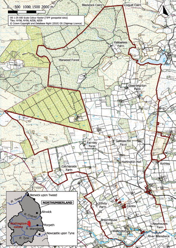
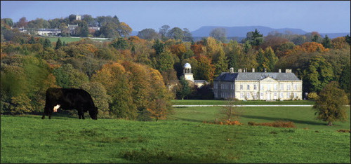
Plate I. Wallington Hall surrounded by parkland, with the village of Cambo in the background (looking north-east) (©National Trust).
Wallington was given to the National Trust in 1941 by Sir Charles Trevelyan, whose family had been living in Wallington Hall since 1777. On his death in 1958 the Trust assumed control of the estate and ten years later the property was opened to the public (Rutherford Citation2016, p. 19). The Trevelyans acquired Wallington from the Blacketts, whose ancestor Sir William Blackett had bought the estate from the Fenwick family in 1689; he built the present Hall on the site of a medieval tower and adjoining stone house (Hodgson Citation1827, pp. 252–78). Fine country houses surrounded by landscaped grounds, like Wallington Hall, were constructed throughout the region in the seventeenth and eighteenth centuries. Many of them incorporated medieval towers or bastle houses whose fortifications reflected the need for defence during periods of border warfare and raiding in medieval and early post-medieval times (Williams Citation2008, pp. 78–82).
Besides building Wallington Hall and a series of parks and pleasure grounds, the Blackett family was also responsible for agricultural improvements and industrial developments (including coal mining) which significantly changed the character of the estate (Newman Citation2018). Between 1729 and 1777, Sir Walter Calverley Blackett transformed the Wallington landscape by creating many miles of straight field boundaries and roads and by building several new farms.
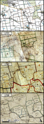
These changes are easily traced by comparing three eighteenth-century estate maps kept in the Wallington archives, the first from 1728 (1:15,840), the second from 1742 (1:15,840) and a third from 1777 (1:7,920) (). They show that the landscape of severalty farms and regular, rectilinear field systems which characterises the area today was for the most part established over the course of the eighteenth century (Debois 2011, pp. 6–12). Such large-scale reorganisations took place across Northumberland between the seventeenth and nineteenth centuries, driven by large estates and associated with agricultural improvement, industrial development, changes in land tenure, and an increased concern for up- to-date aesthetics by landowners as conditions became more settled in the border regions (MacRaild & Purdue Citation2006, pp. 77–85). The resulting ‘surveyor’s landscape’ subsumed earlier patterns of piecemeal enclosures together with the remnants of open fields and nucleated villages which can still be detected on the 1728 map. Unfortunately, we are less well informed about the earlier development and origins of these postmedieval field systems. According to Butlin (Citation1973, pp. 140–4), it is possible that Northumberland witnessed a gradual evolution from a medieval system based on loose groupings of furlongs to one based on one, two, three or more clearly defined common fields by the sixteenth and seventeenth centuries, but the finer details of this transition frequently escape us.
Fig. 2. Details of the estate maps of 1728, 1742 and 1777 (kept in the Wallington Hall archives) compared to the same area on the modern 1:25,000 OS map.
Medieval written sources like the Lay Subsidy Roll of 1296 inform us that by the thirteenth century the area of the current estate comprised at least nine townships or vills, namely Wallington, Cambo, Catcherside, Fairnley, Hartington, Rothley, Harwood, Greenleighton, and Fallowlees (Fraser Citation1968; Hodgson Citation1827, pp. 251–307). How this settlement pattern and its associated openfield farming landscape came about is hard to tell because, as in much of Northumberland, there is an awkward gap in the archaeological record for rural settlements on the estate between A.D. c. 400–1200. It is therefore uncertain when the nucleated villages typical of the later Middle Ages were established and how long people continued to live in the dispersed farmsteads and hamlets characteristic of the late prehistoric and Romano-British periods (Evans et al. Citation1988, p.186; Gates Citation2002, pp. 10–16; Lomas & Muir Citation2006, pp. 55–7; Tolan-Smith Citation1997, pp. 8–10).
METHODOLOGY
To better understand how the estate’s rural landscape was formed over the long term, and how elements from earlier landscapes contributed to the heritage of later periods, it was necessary to first identify and inventory historic earthwork boundaries and remnants of arable farming. The 1728 estate map was a particularly important source in this respect, as it could be used to recognise the remains of boundaries which were established before this date and are still present in the current landscape (). To understand and contextualise these features within their wider surroundings, a range of different data sources available for the study area were consulted and integrated in a GIS (Geographical Information System) environment. This included archaeological records held in the Northumberland Historic Environment Record (NHER) (including the Northumberland Historic Landscape Characterisation), historic written documents kept in the Wallington archives and the Northumberland Archives at Woodhorn, and spatial data sources such as historic and modern maps and aerial photographs (see, for example, Gates Citation2002). A recent survey of the estate which produced a catalogue of its current field boundaries was also consulted (Debois 2011).
Fig. 3. Georeferenced estate map of 1728 indicating which boundaries are still present in the current landscape and the location of the five boundaries studied using OSL-PD.
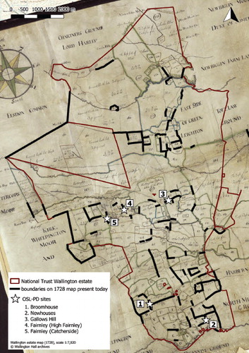
Retrogressive landscape analysis of these data sources using GIS led to the selection of five earthworks which were deemed most suitable for further investigation on-site, combined with sampling for OSL-PD to gain more insight into the detailed chronologies of the features ().
The earthworks we examined are all depicted on the 1728 map, providing a terminus ante quem, and were assumed to originate at different stages in the enclosure of the local open-field systems. On the 1728 map they belong to the territories of different townships and delimit arable fields as well as pasture and meadow. Each one represents a distinctive type, ranging from stone-faced banks to simple earth banks. Some are out of use while others still serve as field boundaries today. The exact locations for sampling were chosen to minimise the impact on each boundary, for example by exploiting areas which had recently been eroded by animals.
Conventional OSL dating has been used for over twenty years to date sediments found in archaeological excavations. Luminescence results from energy retained in certain minerals, typically quartz and feldspar, as a consequence of naturally occurring ionising radiation in both the samples and their environment. Luminescence signals are depleted when the minerals are exposed to either heat or daylight; exposure to light during phases of erosion or transport can act as a ‘zeroing’ mechanism. Once the sediment is buried and protected from light, luminescence will grow in situ in response to the radioactivity of the surrounding sediment. This can be quantified as the equivalent dose (or burial dose), which is determined by calibrating the intensity of the OSL signal against the response to known laboratory-administered radiation doses. This value is divided by the environmental dose rate to give the OSL age (Yukihara & McKeever Citation2011). In this research we used a SUERC portable OSL reader to appraise the sediment stratigraphies associated with medieval and later boundary features and provide temporal constraints on their construction (the equipment has been used previously to assess other types of natural and archaeological sediment profiles, e.g. Portenga & Bishop Citation2016; Kinnaird et al. Citation2017; Turner et al. Citation2018; Vervust et al. Citation2020). By using the portable reader it is possible to characterise the luminescence stratigraphies of each earthwork in the field, immediately providing a relative chronology for their development (Kinnaird et al. Citation2017). The results from field profiling were used to inform sample selection in real time for subsequent OSL analytical work in the CERSA Luminescence laboratory at the University of St Andrews. Field profiling helps to ensure that it is the key stratigraphic horizons — representing the most significant phases in the development of the earthwork — which are targeted for dating. This strategy provides a significant improvement compared to conventional scientific dating methods which often have to rely on a small number of arbitrarily placed dating samples. Furthermore, the combination of field profiling with subsequent lab-based OSL-PD can enable us to assess the chronological development of the complete sediment profile of each earthwork.
Fieldwork was carried out over the course of three days in February 2018. Small trenches were cut by hand into each of the five boundaries and protected from light under a dark cover for sampling. In total 105 small bulk samples (5–10 g) were removed from the exposed profiles and interrogated with the portable reader, after which a further eleven larger dating samples were collected. A detailed description of the methods and results of the dating programme at Wallington is provided in the Supplementary Material for this paper (see online).Footnote1
CASE STUDIES ()
1. Broomhouse
The first feature we investigated is located in the south-west of the estate, in a field currently used as pasture, belonging to Broomhouse Farm. It is a 350 metre-long curving earthen bank, about 3 m wide and 0.5 m high, running approximately north– south. It has the reverse-S shape characteristic of medieval ridge and furrow, suggesting it was once a furlong boundary. Although it does not function as a field boundary today, on the 1728 estate plan it forms the dividing line between three fields belonging to the respective territories of Broomhouse (V) to the west of the earthwork, Elfhills (36 — The South field) and Cambo (15 — The West field) to the east. This must have been a boundary of some importance in the past, since in or around 1770 several boundary stones were set into its crest to mark clearly the distinction between the lands to the west where no tithes needed to be paid and those to the east where they were payable (NHER 17587-90, 17593). Three small trenches of c. 0.8 m wide and 0.7 m deep were cut into the earthwork: one on its west side, one in the centre, and one on its east side. Their luminescence stratigraphies all showed a progression from lower to higher signal intensities down-profile, but with prominent spikes and local inversions at greater depths. These maxima in intensities occur at a position in the sedimentary profile above the boundary between grey, clay loam (the substrate) and a brown, sandier loam (the bank). Dating samples in the western and central trench, placed immediately above these spikes in the profile, suggest a construction date between the mid-thirteenth and mid-fourteenth centuries (A.D. 1250±190 for CERSA198; A.D. 1370±60 for CERSA199).
Fig. 4. The five investigated boundaries shown on the modern 1:25,000 OS map, the estate map of 1728 and a photograph taken during fieldwork.
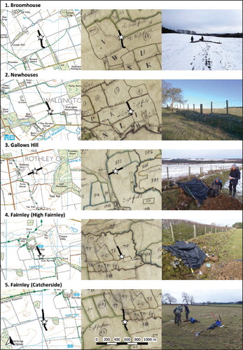
2. Newhouses
The second feature examined lies 1 km east of Wallington Hall. The boundary extends north– south for 250 metres as a stone-faced earth bank about 0.9 m high and 1.5 m wide, lined with a few hedgerow trees. It currently separates two pastures belonging to Newhouses Farm. The situation depicted on the 1728 map is more or less the same, the boundary being marked with a hedgerow and separating two fields in the territory of Newhouses. The remains of the deserted medieval village of Wallington (NHER 10504) are believed to be located in the field west of the earthwork (K — Broad Thorns), which might therefore divide what had formerly been a large arable field belonging to the village. A section 1.2 m deep and 0.7 m wide was cut in the face of the bank. The exposed profile displayed consistent OSL signal intensities through the earth core of the feature until reaching a prominent stone horizon at a depth of about 0.9 m, approximately at the current ground level. Soils below this horizon are characterised by considerably higher signal intensities. Field impressions were that the earth core of the feature was deposited in a single event (potentially packed at construction), that the stone horizon must relate to construction, and that this overlies a buried soil of older age, which exhibits a more stable and prolonged time-depth. Dating samples were placed at the bottom of the stony horizon to provide a terminus post quem for construction (CERSA200: A.D. 1030±170) and immediately beneath it, to provide a constraint on the buried soil (CERSA201: 1710±2250 B.C.). These depositional ages confirm the existence of a clear temporal discontinuity in the stratigraphic sequence. The OSL evidence suggests the earthwork was constructed after A.D. 1030±170.
3. Gallows Hill
Fieldwork in the central part of the estate targeted an earth bank about 0.5 m high and 2.5 m wide which extends approximately west–east for 300 metres immediately east of Gallows Hill Farm. This earthwork currently separates two pasture fields, but in 1728 it was one of the only boundaries in a huge expanse of unenclosed arable land north of the township of Hartington, splitting the so-called ‘North field’ (101) from the much larger ‘East field’ (98) to the south. The luminescence profile of the feature is rather complex. There are several inversions in signal intensities, but potentially two phases of construction can be identified — assuming it is correct to interpret higher signal intensities as residual and ‘dumps’ associated with growth of the bank, and lower signal intensities as bleached horizons. A dating sample collected 0.2 metres below the current ground level, immediately above the substrate (which corresponds with the lower of the two construction events noted above), suggests that the earthwork originated in late medieval times (CERSA202: A.D. 1230±150).
4. Fairnley (High Fairnley)
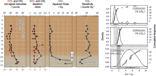
This stone-faced earthwork lies immediately south-east of Fairnley Farm in the central area of the estate. It comprises a bank approximately 0.9 m high and 1.7 m wide, running northwest by south-east, which currently forms the division between two pasture fields. On the 1728 estate map the same boundary separates the ‘East field’ (70) from ‘A pasture north of the Dealls’ (71). These two fields together with the ‘Middle Close’ (72) adjoining them on the west side presumably once formed one larger field belonging to the deserted medieval settlement of High Fairnley (NHER 10417) whose remains lie just north of the modern farm, though they are not shown on the 1728 map. Further evidence in support of this theory comes from the traces of ridge and furrow which are very similar in terms of orientation and spacing throughout these fields. The luminescence profile of the earthwork shows comparable OSL signal intensities throughout the core of the upstanding bank, with a shift to a signal-depth progression to higher intensities beneath ground level, which was taken as evidence that the ‘surface’ of buried soil was disturbed and bleached at construction (). A dating sample (CERSA203) placed immediately below the surface provides a terminus post quem of A.D. 1550±50 for the construction of the feature. Another dating sample (CERSA204) from 0.1 metre lower in the profile, placed just above the grey clayey loam of the substrate, seems to represent a former ground surface, providing evidence for agricultural activity in the area around A.D. 970±70. The third sample in the sequence (CERSA205), located 15 cm into the grey sub-soil was characterised by a heterogeneous mix of equivalent doses (), which indicates that this sediment is mixed-age and was not completely bleached at deposition.
Fig. 5. Luminescence profiles for the bank appraised at Fairnley (High Fairnley). See . Also shown are the equivalent dose distributions for samples CERSA203, 204, and 205. See also Supplementary Material (online) (Note 1).
5. Fairnley (Catcherside)
The final feature to be examined was a 400 metre-long earth bank, which runs north–south across land at Fairnley, about 500 metres west of the modern farm. The section sampled was located on the southern stretch of the feature, approximately 60 metres to the south of the Fairnley Burn, where the earthwork is about 2.5 m wide and 0.6 m high. On the 1728 plan, this southern stretch is shown as the boundary between a pasture on Catcherside territory to the west (65 — East Pasture) and a meadow on Hartington Hall territory to the east (58 — Whitridge Law). The boundary seems to have fallen into disuse shortly afterwards because it no longer features on the 1742 estate map, having been replaced by a straight boundary immediately to the west which is still in use today. The luminescence profile of the earthwork demonstrates normal age-depth progressions through 17 to 51 cm depth and 57 to 79 cm depth, but with a large temporal break between these ‘units’, which is just above the present-day ground level. Dating samples were positioned directly beneath and above this discontinuity to constrain construction for the earthwork. The earthwork was constructed in the first millennium A.D., most likely the sixth–seventh centuries A.D. (A.D. 500±460 for CERSA206; A.D. 670±440 for CERSA207).
DISCUSSION AND CONCLUSIONS
At High Fairnley the boundary dating to the mid-sixteenth century is consistent with a general pattern of piecemeal enclosure which has been recognised from documentary sources across the North-East. Historical geographers have argued that the changing political context of the mid-sixteenth and early seventeenth centuries, especially the gradual attenuation of hostilities across the Scottish border, facilitated agrarian change (Butlin Citation1973, pp. 139–40; Smith & Tolan-Smith Citation1997, pp. 58–9). Markets for pastoral products developed rapidly in growing towns and industrial communities at this time; combined with the relatively low rural population from the fourteenth century onwards this may have created conditions favourable to the creation of piecemeal enclosures suited to livestock farming (Dodds Citation2007).
Evidence from the boundaries at Gallows Hill and Broomhouse shows clearly that some enclosures within open fields took place during the later Middle Ages. At Gallows Hill the boundary bank which divides off the northern portion of the former Hartington Eastfield was probably made in the mid-thirteenth century. At Broomhouse the bank which once acted as the boundary between Elfhills, Broomhouse and Cambo was likely constructed in the late thirteenth or fourteenth century. This was a period of substantial social changes related to a series of natural and political disasters including animal diseases, failed harvests, warfare and raiding across the stabilising English-Scottish border. Although most established communities survived these troubles, there seems to have been significant demographic decline in the region, with consequent shrinkage and replanning in local settlements (e.g. at nearby West Whelpington: Evans et al. Citation1988, pp. 142–6), as well as changes in landholding including the emergence of copyhold tenure (Butlin Citation1973, p. 142). According to Hodgson’s History of Northumberland (1827), the manor of Wallington changed hands from the ‘de Crauden’ family to the ‘Grey de Wallington’ family at some point between 1278 and 1326 and remained theirs till it was acquired by the Fenwick family at the end of the fourteenth century. Some of the new landowners in this period — or their existing neighbours — may have felt the need to delineate their boundaries more clearly, particularly if an increasingly pastoral farming system meant there was more livestock and a smaller number of people to manage the herds.
The first documentary evidence for townships at Wallington and Fairnley dates to the end of the twelfth (1168) and the end of the thirteenth centuries (1284) respectively (Hodgson Citation1827, pp. 252, 287). The eleventh and twelfth centuries are thought to have been a time of major changes for settlements in northern England, with the establishment of new villages and the reorganisation of existing ones (Smith & Tolan-Smith Citation1997, p. 56; Roberts Citation2008). The regular layout of many villages in Yorkshire, Durham, Cumbria, and Northumberland has been interpreted as the result of seigneurial planning following devastation by armies loyal to Scottish or Norman kings (Lomas & Muir Citation2006, p. 57; Roberts Citation2008). Although the character and location of settlements before the twelfth century around Wallington remains unknown, it is important to note that OSL-PD samples from the enclosure bank at Newhouses and cultivation soil at High Fairnley suggest farming activities were taking place around A.D. 1000. This hints that the fields here might already have been laid out and exploited during the late Anglo-Saxon period.
Evidence for an even earlier phase of use comes from the Catcherside sediment profile near Fairnley, where sediments below the earth bank which provided the boundary of the holding in 1728 demonstrated it was probably constructed in the first millennium A.D., most likely in the sixth or seventh centuries. Archaeological survey carried out 1 km to the north-west on Hartington Moor showed that the area was occupied from the Bronze Age until the Roman period, but since no permanent settlements of post-Roman date were identified by the surveyors they regarded the area as ‘uninhabited distant land where boundaries need to be marked out’ (Fowler & Strutt Citation2005). The evidence from OSL-PD at Catcherside shows that at least one boundary was indeed marked out during the first millennium using an earth bank to delimit what later (if not originally) became a particular holding in the medieval farming landscape.
The fieldwork and the dating programme at the Wallington estate were focused on boundaries which are known from map evidence to have existed by the early eighteenth century. One was found to have been created in the early modern period, but the others are most likely to have been constructed during the Middle Ages. The research demonstrates that medieval farmers were working the area well before local settlements were first recorded in documents, and shows that early field patterns continued to influence the organisation of the landscape in the area despite subsequent episodes of reorganisation.
Besides the specific results from Wallington, the study demonstrates the potential of an approach which combines field survey and GIS methods with OSL-PD to understand the chronology of earthworks. In upland contexts, where the remains of ancient fields tend to be relatively well preserved, such methods can add precision and detail to existing relative chronologies. In lowland areas, where field systems are more prone to change, the methodology also has excellent potential to reveal important information about different stages in the development of field systems. This is important because earthworks have hitherto been difficult to date using conventional archaeological methods (Vervust et al. Citation2020). Future studies will be able to combine OSL-PD with other soil science methods such as micromorphology, geochemical analysis or the study of plant remains in order to identify not only when farmers were using the land, but also what crops and animals were exploited and how the soil was being cultivated. By using these approaches it will be possible to establish detailed histories of enclosure, land use and farming directly from the evidence preserved in the soil, including for periods and regions which were not documented in any written sources.
Supplemental Material
Download PDF (1.7 MB)Acknowledgements
This project has received funding from the FWO and the European Union’s Horizon 2020 research and innovation programme under Marie Skłodowska-Curie grant agreement No. 665501.
The authors are very grateful to the National Trust’s Wallington estate for its support, in particular to its countryside manager, Paul Hewitt. We would also like to thank George Anderson, Hans Porksen, Ian Cairns and Michael Ansley (who farm at Fairnley, Gallows Hill, Broomhouse and Newhouses respectively) for allowing us access and for their interest in our research. We were assisted in the field by Francesco Carrer, Annie Dury and Adam Leigh, and we thank them all for their help.
Correction Statement
This article has been corrected with minor changes. These changes do not impact the academic content of the article.
Notes
1 Supplemental data for this article can be accessed online at http://dx.doi.org/10.1080/01433768.2020.1835183.
primary sources
- CERSA Centre of Earth Resources, now the CERSA Luminescence Laboratory, School of Earth and Environmental Sciences, University of St Andrews.
- Natural England, 2013. National Character Area Profile: 2. Northumberland Sandstone Hills [online]. https://www.gov.uk/government/publications/national-character-area-profiles-data-for-local-decision-making/national-character-area-profiles [accessed 28 January 2019].
- Natural England, 2015. National Character Area Profile: 12. Mid Northumberland [online]. https://www.gov.uk/government/publications/national-character-area-profiles-data-for-local-decision-making/national-character-area-profiles [accessed 28 January 2019].
- NHER Northumberland Historic Environment Record. Northumberland County Council, Morpeth. https://www.northumberland.gov.uk, 10417, 10504, 17587-90, 17593. See Williams 2008.
Bibliography
- Aalen, F. H. A., & O’Brien, C. (eds), 2006. England’s Landscape. The North East (London).
- Butlin, R. A., 1973. ‘Field systems of Northumberland and Durham, in Studies of Field Systems in the British Isles, ed. A. R. H. Baker & R. A. Butlin (Cambridge), pp. 93–144.
- Debois Landscape Survey Group, 2011. ‘Wallington Hall: parkland and landscape management plan’, unpubl Project Rep for the National Trust.
- Dodds, B., 2007 Peasants and Production in the Medieval North East: the evidence from tithes, 1270-1536 (Woodbridge).
- Evans, D. H., Jarrett, M. G., & Wrathmell, S., 1988. ‘The deserted village of West Whelpington, Northumberland: third report, part 2’, Archaeologia Aeliana, 5th ser, 16, pp. 139–92.
- Fowler, P. J., & Strutt, K. D., 2005. ‘An archaeological survey of Hartington Moor on the Wallington Hall Estate, near Morpeth, Northumberland’, Archaeologia Aeliana, 5th ser, 34, pp. 1–27.
- Fraser, C. M., 1968. The Northumberland Lay Subsidy Roll of 1296 (Soc Antiq, Newcastle upon Tyne).
- Gates, T., 2002. ‘The Archaeology of the Wallington Estate: an air photographic survey’, unpubl Project Rep for the National Trust.
- Hodgson, J., 1827. A History of Northumberland. Part II vol I (Newcastle upon Tyne).
- Kinnaird, T. C., Bolòs, J., Turner, A, & Turner, S., 2017. ‘Optically-stimulated luminescence profiling and dating of historic agricultural terraces in Catalonia (Spain)’, J Archaeol Sci, 78, pp. 66–77. doi: 10.1016/j.jas.2016.11.003
- Lomas, R., & Muir, R., 2006. ‘The North East in the medieval period’, in England’s Landscape. The North East, ed. Aalen & O’Brien, pp. 53–76.
- MacRaild, D. M., & Purdue, A. W., 2006. ‘The North East: Modern period’, in England’s Landscape. The North East., ed. Aalen & O’Brien, pp. 77–108.
- Newman C., 2018. ‘An investigation of the design and evolution of the Rothley Lakes landscape, Wallington, Northumberland’, Archaeologia Aeliana, 5th ser, 47, pp. 201–21.
- O’Donnell, R., 2015. Assembling Enclosure. Transformations in the rural landscape of post-medieval north-east England (Hatfield, Hertfordshire).
- Petts, D., & Gerrard, C., 2006. Shared Visions: the North-East Regional Research Framework for the Historic Environment (Durham Cty Counc, Durham).
- Portenga, E., & Bishop, P., 2016. ‘Confirming geomorphological interpretations based on portable OSL reader data’, Earth Surface Processes & Landforms, 41, pp. 427–32. doi: 10.1002/esp.3834
- Roberts, B., 2008. Landscapes, Documents and Maps: villages in Northern England and beyond AD 900-1250 (Oxford).
- Rutherford, S., 2016. ‘Wallington, Northumberland: designed landscape action plan’, unpubl Project Rep for the National Trust.
- Smith, J. E., & Tolan-Smith, C., 1997. ‘The medieval landscape 2: Welton deserted medieval village’, in Landscape Archaeology in Tynedale, ed. Tolan-Smith, pp. 53–67.
- Thirsk, J., 1967. ‘The farming regions of England’, in The Agrarian History of England and Wales. Volume IV 1500–1640, ed. J. Thirsk (Cambridge), pp. 1–112.
- Tolan-Smith, C., 1997. ‘Landscape archaeology’, in Landscape Archaeology in Tynedale, ed. Tolan-Smith, pp. 1–10.
- Tolan-Smith, C. (ed.), 1997. Landscape Archaeology in Tynedale. Tyne-Solway Ancient and Historic Landscapes Research Programme Monogr 1, Dep Archaeol, Newcastle University (Newcastle upon Tyne).
- Turner, S., Bolòs, J., & Kinnaird, T. C., 2018. ‘Changes and continuities in a Mediterranean landscape: a new interdisciplinary approach to understanding historic character in western Catalonia’, Landscape Res, 43 (7), pp. 922–38. doi: 10.1080/01426397.2017.1386778
- Vervust, S., Kinnaird, T., Herring, P., & Turner, S. 2020. ‘Optically-stimulated luminescence profiling and dating of earthworks: the creation and development of prehistoric field boundaries at Bosigran, Cornwall (UK)’, Antiq, 94 (374), pp. 420–36. https://doi.org/10.15184/aqy.2019.138.
- Williams, L., 2008. Northumberland Historic Landscape Characterisation, Northumberland Cty Counc, Northumberland National Park & English Heritage (Morpeth, Northumberland).
- Wrathmell, S., 1975. ‘Deserted and shrunken Villages in southern Northumberland from the twelfth to the twentieth centuries’, unpubl. Univ Wales Cardiff Ph.D. thesis.
- Yukihara, E., & McKeever, S., 2011. Optically Stimulated Luminescence: fundamentals and applications (Chichester).