
ABSTRACT
The dataset acquired by an echo sounder generally comprises outliers and erroneous measurements which must be automatically processed. The main aim of this research is the development and validation of an algorithm which permits detecting outliers, estimating their real value from data acquired with a multifrequency echo sounder, and verifying the measure according to the desired accuracy. The process considers the nature of the seabed and improves the density and number of lectures without globally compromising the precision, but enhancing it in areas with anomalous measurements. Twenty-nine percent of this type of measurements, which would have been otherwise rejected, have been estimated.
Introduction
Echo sounder surveying is a common technique for underwater mapping. In addition to being numerous, the measurements thus obtained present anomalous values with a certain frequency, which is estimated to be lower than 1% (Debese Citation1997). These anomalous values are due to many causes and make it necessary to postprocess the data. As many authors propose (Debese Citation2007), the presence of anomalous readings could be treated by techniques aimed to detect and remove them, but the grouping of this type of measurements can lead to lack of data and, therefore, to a loss of accuracy in the bathymetry as a whole.
The processes aimed to detect these outliers have evolved over time. Hence, during the 1990's they were based on the analysis of the statistical properties of the data (Ware et al. Citation1991), including statistical tests to validate the size of their neighboring values (Eeg Citation1995). Recent studies have been performed using kriging modeling techniques (Bottelier et al. 2005), Kalman Filter (Calder and Mayer Citation2003), or robust estimation procedures (Debese et al. Citation2012; Lu et al. Citation2010). These works seek the detection of anomalous readings to remove them. This research proposes a methodology for multifrequency echo sounders that allows detecting, estimating, and replacing anomalous values, whenever possible, and without loss of quality, from the measured data themselves. It includes the variability of the roughness parameter, which has been introduced by other authors (Hellequin Citation1998). This methodology can be applied during the acquisition of depth readings, providing a gapless set of data, and assuring the required accuracy. The density of measured points depends on multiple factors, including the echo sounder parameters themselves (Calder and Mayer Citation2003), or even the route followed by the boat (Maleika Citation2013). These anomalous values can compromise the density, especially if they are grouped, or when performing a bathymetry in shallow water, where the highest possible accuracy is required.
Applications in civil engineering (construction of dams, decks or submarine emissaries, dredging of harbors, determination of the volume of operating water reservoirs, definition of profiles for flood calculation in rivers, etc.) usually require detailed bathymetries, which are constrained to small areas and must be as accurate as possible. That is the reason why a simple removal of erroneous depths can lead to a significant decrease in the number of points that define the bathymetry, affecting the generated model (Gosciewski Citation2014). This fact can be especially critical in areas with a lower density of measurements, producing an important loss of data in the end, and hence, also of accuracy (Maleika Citation2015).
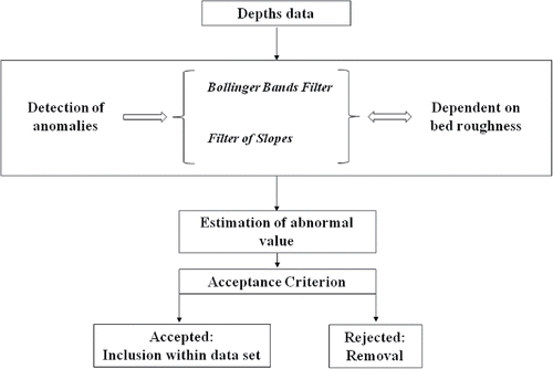
This research aims to locate anomalous depth readings by the use of multifrequency echo sounders data. The proposed methodology for their estimation and validation, if appropriate, takes into account the character of the bed, which is determined by the depth measurements themselves. Hence, a minimal loss of data is achieved. The quality of all these data and, therefore, the homogeneity of the bathymetry as a whole is assured. shows the model proposed for the processing and estimation of depths.
Figure 1. Scheme of the depth processing and estimation model.
Materials
Hydroacustic sensors comprise two main groups: echo sounders and imaging sonars. Single beam, multibeam, and interferometric echo sounders can be distinguished within the first category. Conceptually, both single beam and multibeam echo sounders can be treated in a similar way, as their main difference is the number of transducers (ASCE Citation1998; USACE, Citation2002).
In bathymetries applied to the field of civil engineering, depth readings are usually obtained by echo sounders, whether single beam or multibeam. In both cases, the devices can be single frequency or multifrequency. In all of them, the depth measurement is obtained by an algorithm that estimates the two-way travel time of an acoustic wave between the transducer and the bed (Brekhovskikh and Lysanov Citation1991).
This paper focuses on measurements acquired with multifrequency echo sounders, and particularly on dual frequency devices. The Atlas Elektronic device applied for this research works with two frequencies: 33 kHz and 210 kHz. As every point is defined by two depth readings, one value can be estimated by relating it to its couple. In addition, the quality of this estimation can be determined by relating them to their neighbors.
Methodology
As it has been mentioned, a method to estimate anomalous measurements from dual frequency echo sounders results from this research. In these devices, the data acquisition generally allows estimating readings considered as anomalous values with higher certainty than when working with single frequency echo sounders, due to the availability of more than just one reading for each point. This method is also suitable for measurements taken with single frequency echo sounders, although with lower robustness. For the work presented in this paper, it is proposed to identify anomalous values and after that, to substitute them with estimated values that guarantee the accuracy. Both the typology and variability of the bed are taken into account. On this purpose, the developed method, called “double-filter,” is applied. It considers estimations used in other fields of science, such as economics (Liu et al. Citation2006; Lubnau and Thodorova Citation2015), and it applies nonlinear interpolation and extrapolation.
In short, the designed methodology allows an automatic process of echo sounder readings and, whenever possible, the use of the available data to estimate those which are considered as “anomalous,” without any loss of accuracy. Hence, the model of the submerged terrain comprises the largest possible quantity of data and does not show areas without measurements. This implies a higher precision in these areas and a more homogenous accuracy in the bathymetry as a whole.
Basically, the stages related next are needed to be considered for this purpose: detection of anomalous depth readings and application of a methodology to estimate depths, which provides a better approximation to their actual values, discriminating those cases for which the calculation of the estimated value is not convenient, as it compromises the accuracy.
It is worth noting that the precision of the bathymetry does not only depend on intrinsic factors of the algorithm proposed. Several other factors have an influence, such as the criteria for the design of measurements (Hughes Clarke Citation2000), the accuracy of the measuring device, and the movement of the boat (Pereda et al. Citation2004).
Detection of anomalies
Anomalous depth readings obtained with an echo sounder are usually few in number, but they are high in terms of magnitude. They are produced by a wide range of phenomena, which generally entail multiple acoustic reflection paths (Debese Citation1997): submerged objects, turbulences, etc. In addition, they are common in detailed bathymetries, which are generally limited to small areas and aim the highest possible accuracy, because the range of depth often varies significantly within them. In fact, sometimes they can even be due to the characteristics of the acoustic wave applied to perform the measurements. Their detection is always necessary, and its correction, by means of estimation, must be developed whenever possible. Otherwise, the quality of the detailed bathymetry, which should by definition be accurate, would be seriously affected, especially if these anomalous readings were concentrated in a particular area.
Under normal conditions, “wrong” readings are quite away from the expected values obtained from their previous and following points. However, a jump or “gap” (due to a possible lack of readings of the echo sounder while the boat is still in motion) may alter the detection process. Hence, the technician in charge of the bathymetric surveying will ensure that such gaps in the echo sounder measurements do not occur, or they are as small as possible.
The detection of anomalous readings is favored by their character. Firstly, readings valued zero are relatively common, and therefore, they are easy to detect. Secondly, whenever not null, depth measurements are quite away from the “real” values. Nevertheless, their detection may not be that simple, especially when working with shallow waters and important changes of depth with respect to the measurements.
Due to these reasons, the automatic detection of anomalous depth readings by means of dual filter is proposed. A record of depth will be considered as anomalous whenever it does not pass any of these filters. Pieces of real files acquired by echo sounder in different types of beds, both regular and irregular, have been adopted as samples for the quantification of the involved parameters. The two filters are described next.
Bollinger Bands filter
The filter based on Bollinger Bands (Bollinger Citation2006) aims to estimate a reading from a certain number of previously taken records. The reading is set to be comprised within a range defined by a mean and a width, which is a function of a certain statistical parameter. In this case, the parameters considered are a weighted average and a width obtained by multiplying the standard deviation (calculated from a certain number of values), by a whole number defined by the user .
A weighted average based on the time of record has been proposed to center the band that defines the validity zone of the readings, since it seems logical to assume that a certain reading is closer to the previous one than to any other. The bandwidths have been defined considering the standard deviation of the previous n0 values.
Thus, given that the bandwidth is a function of the standard deviation of a certain number of values, it would result too small for relatively flat areas with little variation in depth readings. This would not allow a variation in depth for the following reading, which would not necessarily be true. Due to this reason, a minimum bandwidth has also been defined to palliate such type of phenomena. This parameter is known as “maximum roughness” or “roughness,” whose calculation will be defined later. Roughness has been introduced by other authors (Hellequin Citation1998; Eleftherakis et al. Citation2012; Eleftherakis et al. Citation2014).
According to this, the parameters to be tested are essentially the bandwidths. There are two widths which can be modified by the user on the basis of the estimating method proposed. The first one is the location considered as anomalous of a certain depth reading which corresponds to the record i. The second one permits discerning whether the record i + 1 is anomalous or not, in order to be able to estimate by means of interpolation or extrapolation if needed.
In brief (), the following condition must be fulfilled to consider the depths corresponding to a certain record i as nonanomalous:(1)
Figure 2. Bollinger Bands filter parameters.
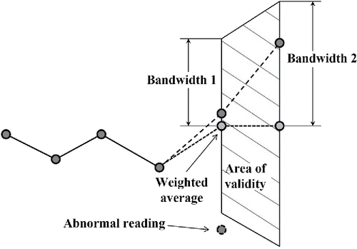
In addition, the depths belonging to the record i + 1 must meet the following requirement to be considered as nonanomalous too.(2) where:
is the depth reading.
is the weighted average of the n0 values prior to the considered one (i).
is the standard deviation of the n0 values prior to the considered one (i).
The thus designed filter works very well when the anomalies are punctual, without a long interval of time between the studied record and the last valid one. That is to say, they are temporarily close. However, if that long lapse of time occurs, the method will tend to consider any measurement as anomalous. This is the reason why the detection of anomalies must be completed with the second filter proposed. The filter of slopes takes into account the distance or time between the studied readings.
Filter of slopes
The filter of slopes departs from the definition of a parameter which is called slope (Sl). It is defined as the relation between two depth readings (Δr), and the difference of time between both measurements (Δt):(3)
The definition of the slope as a control element corresponds to the necessity to set some continuity in the bed topography. The slope behaves in a much more reliable way than depth readings, as the variation of the latter depends not only on the underwater topography, but also on the interval of the measurements. This circumstance is evidenced by the cases considered in this research.
The method is very similar to the Bollinger Bands one, but it adopts the previously defined slopes instead of the depth readings. Hence, it basically consists of validating a depth reading if the slope presents an admissible variation with respect to the previous ones. The interval thus defined must comprise that slope in order to consider the reading as adequate.
The main difference between this method and the Bollinger Bands one is the introduction of time as a parameter. Should any assumable discontinuity exist in the echo sounder files, this fact would support the study of anomalies.
In short, the study of a certain reading, i, defines an expected slope, using a Lagrange polynomial generated with the three previous values of slope (Abramowitz and Stegun Citation1972).(4) where
pk is the depth reading.
tk is the time when certain depth is measured.
L3,k is the Lagrange interpolating polynomial.
The existing slope defined by the depth which is desired to be checked will be that calculated for time t i, Pde(ti). The followed strategy consists in the detection of excessively steep slopes by the comparison between the expected slope, Pde(ti), and the obtained one, Pdm. The latter will be defined by the following expression:(5)
In order to consider any reading as adequate, it must be comprised by an interval centered in the expected slope. Therefore, the following expression summarizes the condition that must be satisfied by a slope to be considered as nonanomalous:(6)
However, the value of the expected slope can be even adopted as the previous slope, easing the calculation process.
The value of the factor of slope Fslope obtained from the validation of this method will be developed in following sections, purposing some values which have been contrasted conveniently.
Bed roughness
When detecting anomalous values in depth readings with any of the methods proposed, it is necessary to define a parameter of maximum roughness. Its justification lies on the fact that the filtering methods proposed define a range of variability for the studied reading, which is directly proportional to the variability of the previous records. Therefore, both are predictive methods that work on the basis of previously acquired values. It is mandatory to define a maximum variability, which must be considered a priori as correct and ensure a certain variation of a reading, even though the previous ones were totally homogeneous. The nature of the measured bed is thus introduced, being used by several authors to classify its typology in different ways (Ferreti et al. Citation2015).
The maximum roughness (RMAX) is calculated as the maximum expected variation between two consecutive readings of the echo sounder (ΔrMAX), considering the speed of the boat (SBoat), the recording period of the device (Δtr), and the type of bed (TBED).(7)
Differences between consecutive depth readings are determined for its calculation, applying them to define the maximum admissible jump occurred.
As this parameter is required before any processing and, therefore, it is needed for the estimation of anomalous readings, it is necessary to manage the raw files of the echo sounder. There are some out-of-range values or outliers among the initial data of differences between consecutive depth readings. Hence, the applied technique aims to determine the values prior to these outliers.
The first consequence of the use of raw files is the common appearance of anomalies, which are desired to be corrected. In order to minimize their number, it is proposed to remove all the null depth readings and also those which are higher than a certain depth set as maximum. That is to say, all the gross outliers.
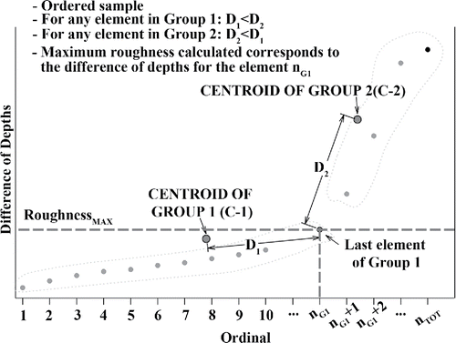
After removing all these gross out-of-range measurements, the differences between consecutive depth readings are calculated and the data are arranged to create groups or clusters, applying “k-means clustering” as described in MacQueen (Citation1967). This technique sets the definition of a series of groups whose members are the closest to their centroids. In this case, two groups comprising all the elements which are closer to their own centroid than to that of the other group, are generated with the ordered differences between readings. On this purpose, any element has two coordinates: an abscissa, corresponding to an ordinal which represents its position among all the differences of depth readings sorted from least to greatest, and an ordinate that is precisely the value of the difference of depth readings between consecutive measurements. For a certain group and considering the Euclidean distance, the coordinates of its centroid are the averages of the coordinates of all the elements of that group.
On the basis of this definition, the elements belonging to the first group are those with a low difference of readings. A second group, on the right, will include all the out-of-range values. The maximum roughness will be defined as the ordinate of the last element of the group number 1, identified by its abscissa nG1, which also corresponds to the number of elements of the group ().
Figure 3. Group formation. “K-means clustering” technique.
Estimation of anomalous readings
As already mentioned, the following method has been studied to take advantage of depth readings. It is especially targeted at the case of dual frequency echo sounders, and it allows detecting and estimating readings considered as anomalous by means of the so-called double-filter method whenever possible, with interpolation and nonlinear extrapolation.
The strategy involves the possibility to generate second-degree polynomials, according to Lagrange interpolation polynomial, from the adjacent measurements to a certain one, which allows estimating a depth reading. These polynomials will be suitable to extrapolate a certain value if they are obtained from the previous three values, or to interpolate it if they are formed with the previous two values and the following one. The advantage of dual frequency echo sounders is the possibility to generate three Lagrange polynomials, corresponding to each of the depths and the difference between them.
The general process to follow consists of estimating the value when, at a given time, a depth reading has been detected as anomalous, while the one obtained with the other frequency has been accepted.
Hence, whenever a certain record comprises an anomalous depth reading for one of the frequencies, and a nonanomalous one for the other frequency, the three previously mentioned polynomials allow obtaining two values for the anomalous depth reading. The first value (pe1) can be obtained from the interpolating or extrapolating polynomial, depending on the case, and the second value (pe2) can be obtained from the nonanomalous depth reading of the same record, and the polynomial of the differences between depth readings.
This method proposes the estimation of the anomalous value (p2) as a weighted average of both values (pe1 and pe2), following Eq. Equation(8)(8) :
(8)
Greater weight is given to the value that depends on the difference of depth readings, pe2. The variations that it shows are generally less abrupt. The value of the weight parameter (M), which will be discussed later, basically depends on the type of bed.
In addition to this, the difference between pe1 and pe2 permits defining the parameter Δe, which must not be greater than a certain value to consider the estimated depth as correct. It will depend on the type of bed and, mainly, on the level of detail or the altimetric accuracy aimed. shows guide values which meet the altimetric accuracy required for certain mappings.
Table 1. Guide limit values for Δe.
The most complete way to estimate anomalous depth readings when registering with echo sounder consists of combining both the interpolation and extrapolation methods, to seize the advantages of each one.
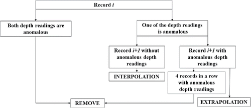
As a general rule, it can be applied in the case of multifrequency echo sounder readings with isolated anomalous readings for one of the frequencies, that is to say, without a series of more than three or four consecutive anomalous values.The operative sequence () can be summarized by the following main aspects:
| – | If a record has anomalous depth readings for more than one frequency, it will be removed, not being suitable for application any of the methods described. | ||||
| – | If any of the depth readings belonging to a record is anomalous, and the following one is complete, interpolation method will be applied. | ||||
| – | If a record is incomplete due to just one of the depths (anomalous value) and so is the following one due to any or both readings, extrapolation method will be applied. If three or four incomplete records are registered, the previous method will be only applied to the cases of sandy or loamy beds. | ||||
| – | For series of more than four incomplete records, depth values will never be approached and they will be removed, as it is considered that the bed conditions can have varied in a significant way as a function of time. | ||||
Figure 4. Scheme of depth estimating process.
Results
Data from real bathymetries performed with different beds, both regular and irregular, which do not present any type of anomalies, have been used for the validation of the proposed method. An anomaly has been manually included in order to check the set of operations that are described below, and to be able to apply them to real and complete bathymetric surveys.
The calculation of the maximum roughness has considered the global raw data of the samples used to check the applied method. At this point, the centroid definition clearly sets the quality of the groups established. Hence, group number two, which is located on the right and is likely to have been generated from “anomalous” depth records, could include a remarkable number of correct data. That is the reason why the centroids have been calculated with a weight assignation to every element (the difference of readings) relating each of them to a certain statistic. shows the results for the maximum roughness values, which have been obtained from the raw files of bathymetric campaigns in different areas. Various criteria have been considered to set these weights. The Port of Comillas has a smooth bed, but rocky areas exist. The Ebro Dam, in Arija, has a smooth sandy bed and very abrupt changes of depth. The Bay of Santander has a regular seabed and relatively brisk changes of depth. The Port of San Vicente de la Barquera has two well-defined areas: one of them has a very smooth topography, and the other one is irregular and has rocks.
Table 2. Maximum roughness validation under different conditions. Four weight criteria have been applied to each site (A: quasi-variance; B: quasi-deviation; C: number of record; D: without weight). Results are given in cm.
As the definition of these groups depends on their centroid, a weighted average has been obtained for its determination. Hence, four sceneries have been proposed for the definition of these weights: without weight, weight equal to the number of record or data, weight related to the standard quasi-deviation, and weight defined on the basis of the quasi-variance.
Had the maximum roughness been defined, pieces of files from bathmetric surveys performed in different sites with an Atlas Elektronic dual frequency echo sounder have been applied to validate the method, avoiding possible systematisms.
Pieces of 30 registers have been chosen. The absence of any kind of anomalies was previously checked in them. From these data, the depth reading has been modified in one of the frequencies for all the cases studied, introducing a known anomaly corresponding to 30%, 50% and 70% of the modified reading. Detection methods have been studied too, with the introduction of a gap of 3 and 5 records just after the one in which the anomaly has been set.
Since there is a single anomaly in the file applied, an ideal situation is sought; once the filters have been applied, the resulting number of anomalies will be one and, after detecting it, its value will be estimated by interpolation, being the number of extrapolations equal to zero.
It may be the case that any of the filters could not detect the anomaly. If it happens, it will be sought that the filter finds it, even though it was located near others, since it is worth reminding that an anomaly will be treated as such if it is detected as anomalous by the two filters: Bollinger Bands Filter and Filter of Slopes.
The parameters that control the two filters proposed for the detection of anomalies and the estimation of the depth considered as anomalous have been checked. Hence, samples from bathymetries without anomalous values have been used. As it has been described, one outlier has been included in each set of data. For all the cases of anomalies considered, the parameters of Bollinger Bands have been studied by varying their value by one unit and the slope factor by 1/10. The correct result has been obtained for the values shown in . All the introduced anomalies, and only they, were detected for these values.
Table 3. Estimation of values for the anomalies detection.
The same samples applied in the previous case have been used to determine the quality of the estimated depth value for the anomalies, classifying them in regular and irregular beds. As the actual reading is known, it has been compared to the estimated one by seeking the value of the previously described parameter M that provides the best fit. In order to do so, the value of the parameter has been varied by 0.5 units, checking the results for each case. shows the results obtained, including M, the extreme value of the differences between the estimated and the real readings rounded to the nearest centimeter, and the standard deviation for that difference.
Table 4. Weight values for depth estimation.
The application of the filter and parameters thus defined to the set of bathymetries has allowed obtaining average values in the number of readings detected as anomalous, estimated and accepted, which accounts for 29% of the total of the spotted anomalies. 68% of them have been obtained by interpolation and the rest by extrapolation.
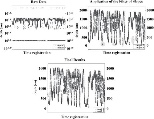
The result of all the proposed operations can be seen in . shows the effect of filtering in a segment of the sample belonging to Arija bathymetry. It is observed that in logs where one of the depths has resulted anomalous, the proposed method has not guaranteed their suitability and it has removed them, thus assuring the quality of the data set. shows the raw data acquired during two hours with a frequency of record of one measurement per second, and the results obtained by exclusively applying the filter of slopes, or the two filters proposed, providing an error-free set of data.
Figure 5. Result of the filter applied to a set of data from Arija bathymetry.
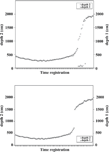
Figure 6. Raw data acquired during two hours, with a record frequency of one measurement per second. Results of the sole application of the filter of slopes. Results of the use of the two filters.
Discussion
Results obtained reveal several remarkable aspects for each of the processes that take part.
Firstly, regarding the calculation of the maximum roughness, as a general rule and whenever the submerged terrain is homogeneous in terms of typology, the best results have been obtained when assigning a weight related to the typical deviation.
However, if the bathymetry comprises areas with rocks and others with regular beds, that is to say, heterogeneous beds, the influence of the measurements in regular areas is particularly high, especially when they are abundant. This is due to the fact that in regular areas, as it is already expected, the differences between lectures in absence of anomalies are low. If many measurements of this type occur, the centroid of group number 1 scrolls to the left, generating an end of group which is placed in an area where the characteristic roughness of a rocky bed does not exist.
In order to correct this effect, a new operation has been developed, which is known as “data compaction.” This operation implies taking the different depth readings and reducing their frequency to just once by value. Therefore, a new sample, without repeating values, is created. The application of this operation to data affected by this situation allows obtaining the results that provide adequate values without the need to assign weights to the measurements. comprises the values of roughness both with and without the development of this data compaction. As it can be observed, the results show great differences for the bathymetries considered, and this operation is required in the case of mixed beds.
Table 5. Maximum roughness validation for mixed beds, under different conditions. Results are given in cm.
Secondly, as it can be seen in , factor M, which allows weighting the average to obtain the depth reading, proportionally increases as the regularity of the bed does. This allows confirming the influence of the difference between depth readings obtained from both frequencies in the quality of the obtained value, which justifies this research.
Furthermore, estimated values show differences with respect to the real measured values lower than 5 cm. As the accuracy of a bathymetry does not only depend on this factor, the rest of participant factors must be considered. However, its value is not critical for the rejection of this technique in depth processing with multifrequency echo sounder. Quite the opposite, it implies a noticeable recovery of depth measurements which would have been otherwise rejected and removed.
Conclusions
The following conclusions can be drawn from these results:
| – | The maximum roughness calculation, as it has been proposed, is essential for the correct processing of echo sounder readings. As it assures a minimal variation between depth measurements, it allows including the variability of the data acquired in each bathy-metry within the proposed process. | ||||
| – | The estimated parameters work properly in each case and for different typologies of beds, which are easily detectable by an experienced operator just by seeing the data, even during their acquisition. | ||||
| – | The estimation of depth values has been developed in 29% of the anomalies, which would have been otherwise removed. This allows reducing the number of measurements lost due to the existence of the anomalous values, which is particularly important when they occur in groups. | ||||
| – | This methodology is suitable both to measurements obtained with single beam and multiple beam echo sounders. For the latter, it can be applied to the direction of the trajectory of each beam, to the set of beams at the direction perpendicular to the trajectory in each measurement, or to a combination of both. | ||||
In short, the proposed methodology allows applying correct depth readings to estimate some erroneous values, while keeping the quality and accuracy parameters in detailed bathymetries. It is obvious that the small errors introduced by the estimated values (lower than 5 cm in the worst case studied), are compensated by the existence of a larger amount of data which could, otherwise, cause areas without measurements.
It is worth noting that other factors such as the boat speed or the cadence between echo sounder records take part in the method. It provides adequate results for usual situations in detailed bathymetries, with boat speeds below 8 km/h and recording intervals lower than 1 second.
Acknowledgements
The authors would like to express their gratitude to the editors and anonymous referees for their work, which have helped them to improve this article in a substantial way.
References
- Abramowitz, M., and I. A. Stegun. 1972. Handbook of Mathematical Functions. New York: Dover Publications.
- American Society of Civil Engineers (ASCE). 1998. Hydrographic Surveying (Technical Engineering and Design Guides as Adapted from the U.S. Army Corps of Engineers, No. 25). Reston: ASCE.
- Bollinger, J. 2006. Las Bandas de Bollinger. Barcelona: Valor Editions.
- Bottelier, P., R. Haagmans, and N. Kinneging. 2000. Fast reduction of high density multibeam echosounder data for near real-time applicatons. The Hydrographic Journal 98:23–28.
- Brekhovskikh, L. M., and Y. P. Lysanov. 1991. Fundamentals of Ocean Acoustics. Berlin: Springer-Verlag, Berlin , Germany.
- Calder, B. R. and L. A. Mayer. 2003. Automatic processing of high-rate, high-density multibeam echosounder data. Geochemistry, Geophysics, Geosystems 4(6):1–22. doi: 10.1029/2002GC000486
- Debese, N. 1997. Typologie des erreus les plus courantes sur les sondes des sondeurs multifaisceaux Simrad et leur impact sur la qualité des produits, Tech, Rep No 007/97. Paris: Ministère de la Défense, Service hydrographique et océanographique de la marine.
- Debese, N. 2007. Multibeam echosounder data cleaning through an adaptive surface-based approach. Paper, U.S. Hydro 2007, Norfolk, May 15–17.
- Debese, N. R. Moitié, and N. Seube. 2012. Multibeam echosounder data cleaning through a hierarchic adaptive and robust local surfacing. Computers & Geosciences 46:330–339.doi:10.1016/j.cageo.2012.01.012
- Eeg. J. 1995. On the identification of spikes in soundings. International Hydrographic Review 72(1):33–41.
- Eleftherakis, D., A. Amiri-Simkooei, M. Snellen, and D. G. Simons. 2012. Improving riverbed sediment classification using backscatter and depth residual features of multi-beam echo-sounder systems. Journal of the Acoustical Society of America 131(5):3710–3725. doi: 10.1121/1.3699206.
- Eleftherakis, D., M. Snellen, A. Amiri-Simkooei, D. G. Simons, and K. Siemes. 2014. Observations regarding coarse sediment classification based on multi-beam echo sounder's backscatter strength and depth residuals in Dutch rivers. Journal of the Acoustical Society of America 135(6):3305–3315.doi: 10.1121/1.4875236
- Ferretti, R., E. Fumagalli, M. Caccia, and G. Bruzzone. 2015. Seabed classification using a single beam echosounder. Paper, Oceans 2015, Genova, May 18–21.
- Gosciewski, D. 2014. Reduction of deformations of the digital terrain model by merging interpolation algorithms. Computers & Geosciences 64:61–71. doi:10.1016/j.cageo.2013.12.005
- Hellequin, L. 1998. Statistical characterization of multibeam echosounder data. Paper, Oceans 1998, Nice, September 28–October 1.
- Hughes Clarke, J. 2000. Present-day Methods of Depth Measurement. Continental Shelf Limits: The Scientific and Legal Interface. P. Cook, and C. Carlton (eds.), 139–159. New York: Oxford University Press.
- Liu, W., X. Huang, and W. Zheng. 2006. Black–Scholes' Model and Bollinger bands. Physica A: Statistical Mechanics and its Applications 131(5):565–571. doi:10.1016/j.physa.2006.03.033
- Lu, D., H. Li, Y. Wei, and T. Zhou. 2010. Automatic outlier detection in multibeam bathymetric data using robust LTS. Paper, 3rd International Congress on Image and Signal Processing (CISP), Yantai, October 16–18.
- Lubnau, T. and N. Todorova. 2015. Trading on mean-reversion in energy futures markets. Energy and Economics 51:312–319. doi:10.1016/j.eneco.2015.06.018
- MacQueen, J. B. 1967. Some methods for classification an analysis of multivariate observations. Proceedings of the Berkeley Symposium on Mathematics Statistics and Probability. L. M. Le Cam, and J. Neyman (eds.), Vol. 1, pp 281–297. Berkley: University of California Press.
- Maleika, W. 2013. The influence of track configuration and multibeam echosounder parameters on the accuracy of seabed DTMs obtained in shallow water. Earth Science Informatics 6(2):139–159. doi: 10.1007/s12145-013-0111-9
- Maleika, W. 2015. The influence of the grid resolution on the accuracy of the digital terrain model used in seabed modeling. Marine Geophysical Research 36(1):35–44. doi: 10.1007/s11001-014-9236-6
- Pereda, R., E. Castillo López, R. Ferrer Torio, J. M. Sánchez Espeso, J. M. de Luis Ruiz, and M. L. Ruiz Bedia. 2004. Definición y validación de un modelo para el movimiento de arfada en trabajos batimétricos de alta precisión. Paper, 4a Asamblea Hispano-Portuguesa de Geodesia y Geofísica - 4a Assembleia Luso-Espanhola de Geodesia e Geofísica, Lisbon, February 3–7.
- U.S. Army Corps of Engineers (USACE). 2002. Engineering and Design: Hydrographic Surveying (Engineer Manual 1110-2-1003). Washington DC: USACE.
- Ware, C., W. Knight, and D. Wells. 1991. Memory intensive statistical algorithms for multibeam bathymetric data. Computers & Geosciences 17(7):985–993. doi:10.1016/0098-3004(91)90093-S