
Abstract
Problem, research strategy, and findings: In this study I investigate whether zoning has traditionally protected communities of color from the dangers of heavy commercial and industrial use to the extent that it has protected White communities. I evaluate whether upzonings—changes from less intensive uses to more intensive heavy commercial and industrial uses—disproportionately occurred in African-American and low-income neighborhoods in Durham (NC) from 1945 to 2014, and I evaluate the comparative impact of downzonings. I use the contemporary demographics of the census tracts where these rezonings occurred and qualitative evidence from public hearings, plans, and other relevant primary materials. I find that before 1985, the pattern of rezonings in Durham had negative implications for African-American areas in particular. Environmental justice efforts in the 1980s, followed by gentrification, caused the city’s planners and local elected officials to change course.
Takeaway for practice: Planners have an ethical obligation to promote equity, and their ability to do so depends on understanding sources of social injustice. In Durham, race historically played a role in upzonings and downzonings involving heavy commercial and industrial uses. The city also demonstrates that planners and local elected officials can successfully intervene to end disparities in zoning practice across communities of different racial characteristics. Assessing past zoning practices in other cities may reveal similar records of bias and help planners to present cases for corrective action.
Cities that zone land for industry too close to residential areas degrade residential property values and risk exposing households to health hazards. One would hope that planning’s most powerful tool, land use zoning, would shield all residential neighborhoods regardless of household economic, racial, or ethnic characteristics because zoning is designed to protect public health, safety, and welfare. Substantial environmental justice research, however, shows that polluting industries and activities frequently locate in low-income communities and communities of color, suggesting that zoning may not shield these communities as well as others.
In this study, I ask three questions about rezonings in Durham (NC) from 1945 through 2014. First, what are the racial and income characteristics of the areas that local elected officials rezoned to heavy commercial and industrial zoning categories from less intensive categories (a type of rezoning I call an upzoning), and what are the characteristics of the areas where land was rezoned from heavy commercial and industrial categories to less intensive categories (a type of rezoning I call a downzoning)? Second, how have the areas where local elected officials upzoned to heavy commercial and industrial categories differed, in terms of race and income, from areas where they downzoned from these categories? Third, has the political empowerment of communities of color challenged any historically unfair treatment? My intent is to expand the scholarly narrative of racial and class bias in zoning practice across zoning’s institutional life in a setting that experienced significant political and economic change.
I find that before the mid-1980s, upzonings to heavy commercial and industrial zoning categories occurred in areas that were significantly less White but not lower income than average. I also find that these upzonings occurred in areas that were significantly less White but not lower income than the areas where downzonings from these categories occurred and conclude that the distribution of rezonings prior to the mid-1980s therefore reflected racial bias. This bias disappeared in the 1980s as African Americans gained political power and both the environmental justice movement and residential gentrification led to changes in Durham’s zoning practices; in fact, once the city acknowledged past inequities, planners and local elected officials were able to effectively use downzonings to redress some of these historical injustices. The Durham case thus shows that planners and local elected officials can use zoning to exacerbate environmental and economic inequality across racial lines, but can also use it to remedy past injustices if the political will to do so exists.
First I review the literature on bias in zoning for heavy commercial and industrial land uses, outlining work that remains to be done. I then review the Durham context, describing how Durham’s location in the American South, its industrial heritage, and its political history make it a good setting in which to address the questions I pose. I then use quantitative and qualitative evidence to contrast the areas where upzonings and downzonings occurred: I organize this analysis into a period from 1945 through 1984 and another period from 1985 through 2014.
Existing Evidence of Bias in Zoning for Heavy Commercial and Industrial Land Uses
American planners of the early 20th century, beginning in New York City (NY) in 1916, used land use zoning to divide cities into areas for residence and areas for industrial and commercial growth. In 1926, the U.S. Supreme Court validated zoning for these purposes with its decision in Village of Euclid v. Ambler Realty Co. The court ruled that planners could use zoning ordinances to organize cities into discrete-use districts for the benefit of all, quoting the Supreme Court of Illinois:
The exclusion of places of business from residential districts is not a declaration that such places are nuisances…but it is part of the general plan by which the city’s territory is allotted to different uses in order to prevent…the congestion, disorder and dangers which often inhere in unregulated municipal development. (Village of Euclid v. Ambler Realty Co., 1926, pp. 392–393)
Thus, American cities took to zoning land use, establishing the permitted uses of properties. Zoning is not set in stone, however; over time, because of either plans or the requests of individual property owners, local elected officials will vote to rezone properties. The exact definitions of upzone and downzone have been neither consistent nor universal throughout zoning’s history, but it has now long been conventional (Smith, Citation1983) to call a rezoning from a relatively less intensive use (e.g., multifamily residential) to a relatively more intensive use (e.g., light industrial) an upzoning and to call the reverse a downzoning. In the American tradition, zoning for single-family detached housing has been the most restrictive categorization, reflecting social mores (Hirt, Citation2015).
An extensive literature within planning and public health reveals that a residential community can face negative consequences if it is proximate to heavy commercial and industrial uses (Bullard, Citation2000; Haggerty, Citation1996; Morello-Frosch & Jesdale, Citation2006; Novotny, Citation1998; Payne-Sturges & Gee, Citation2006). My own qualitative research, which I detail in the following sections, also reveals that Durham residents usually feared that nearby upzonings for industrial or heavy commercial use would have negative consequences such as truck traffic, hazards to children, or accidents, even when businesses or landowners promised economic benefits to local households. Downzonings, in contrast, were generally a means of shielding local residential communities from these negative impacts. The zoning of any property does not mandate its use for that purpose, but it does prohibit any more intensive use and occasionally prohibits some less intensive uses; heavy commercial or industrial zoning therefore does not guarantee an area’s occupation by noisy, hazardous, or odorous businesses. Merely designating land for these uses is, however, significantly detrimental to nearby residential property values (De Vor & De Groot, Citation2011).
Scholars argue that the degree to which zoning shields residential areas from the externalities of heavy commercial and industrial land use is often contingent on the race and class of those living in these areas (Arnold, Citation2007; Colquette & Henry Robertson, 1991; Connerly, Citation2005; Hanchett, Citation1998; Maantay, Citation2001, 2002a, 2002b; Rabin, Citation1989; Sidawi, Citation1997). Most early zoning schemes created exclusive residential districts but also allowed residential construction in industrial and commercial districts. Homes in residential districts were more desirable and thus more expensive, so these zoning schemes effectively segregated lower-income households into neighborhoods open to industrial land uses (Arnold, Citation2007; Young, Citation2004). New York City’s 1916 code included an exclusive residential zone, usually implemented in higher-income areas, whereas its commercial and unrestricted zones were open to residential construction. This maintained convenient proximity of homes to jobs for many working-class households, but it also led to the disproportionate presence of environmental disamenities in low-income communities. Later in the 20th century, planners reinforced this environmental disparity when they rezoned many high-minority mixed-use areas for manufacturing (Maantay, Citation2002b; Sze, Citation2007).
Why might such a disparity be problematic? It is up to local planning staff and volunteer planning commissions to consider the implications of any proposed rezoning for the use and users of any affected properties and advise local elected officials accordingly; individual decisions may reflect any number of concerns or goals. Over time, however, if cities disproportionately zone for industry within lower-income communities or lower-income communities of color specifically, they may be excessively increasing exposure to lead, air pollution, or other hazards among those less able to deal with them. Zoning for these uses within these communities may also threaten the assets of already vulnerable homeowners because of the negative impacts on residential property values (De Vor & De Groot, Citation2011).
It is not surprising that scholars have found many cases in which planners and local elected officials specifically targeted communities of color with zoning for industry given the United States’ history of racial subjugation and industrial zoning’s negative impacts on nearby residential communities. Sidawi (Citation1997) shows how early 20th-century planners of Torrance (CA) permitted Mexican workers to construct a low-income ghetto away from White residential areas and surrounded by industrial zoning on all sides; the planners simultaneously insulated White areas from industrial encroachment. Austin (TX) labeled East Austin a “Negro district” in a 1928 city plan and then zoned the area for industrial use (Greenberger, 1997). In 1959, a model single-family residential community aimed at African-American buyers opened in South Phoenix (AZ), but as the city expanded zoning for industry in the area and failed to prevent the encroachment of substandard dwellings, homeowners in the community saw their property values decline by 85% (Bolin, Grineski, & Collins, Citation2005, p. 164). Connerly (Citation2005) details how the city of Birmingham (AL) used a combination of use zoning and racial zoning to co-locate African-American residential communities with areas zoned for industrial use in the first half of the 20th century.Footnote1 Rabin (Citation1989) uses the term “expulsive zoning” for rezoning residential property to industrial use because it often led to redevelopment and household displacement in African-American neighborhoods. Abrams (Citation1966) mentions a 1960s case in which the city of Milpitas (CA) immediately rezoned an area for industry after a union proposed building housing there for African-American workers. In 1990, St. John the Baptist Parish (LA) rezoned 800 residential acres of an African-American neighborhood for industrial use despite the availability of other land zoned for industry in the vicinity (Colquette & Robertson, 1991). Charlotte (NC) rezoned many of its African-American neighborhoods in 1947 for industrial use to promote their redevelopment (Hanchett, Citation1998). All of these cases suggest that planners and local elected officials have often used zoning to encourage industry to develop in African-American and other communities of color, but they do not always suggest whether they treated White areas similarly.
Other scholars have thus turned to more comprehensive, quantitative studies to better understand whether local zoning practices are discriminatory. Arnold (Citation1998) investigates zoning in 31 census tracts in seven U.S. cities. Each tract had either a high-minority, low-income population or a low-minority, high-income population. He found that the high-minority, low-income tracts had more zoning for commercial and industrial uses, whereas the low-minority, high-income tracts had less commercial and industrial zoning and more areas zoned for single-family residential use. This study is problematic, however, because it did not assess the racial or class characteristics of these tracts at the time they were zoned, leaving open the possibility that zoning in low-income, minority areas was not the result of targeting these populations. Nor do the selected tracts present a comprehensive picture of zoning in any of the seven cities.
Maantay (Citation2001, 2002a, 2002b) examines the demographic characteristics of census tracts within New York City’s manufacturing zones as well as those within a half-mile of parcels that the city rezoned to and from manufacturing use. She assesses the racial and class characteristics of the rezoned areas at the time that the rezonings happened over three decades and across the entire jurisdiction. Maantay finds that residents living in manufacturing zones and residents living near land the city rezoned for manufacturing use were more likely to be lower income and members of a minority group. Maantay also interviews planning staff to substantiate her quantitative findings, discovering that planners selected areas experiencing White flight for rezoning to manufacturing use. Maantay’s mixed-methods approach is especially powerful in demonstrating the inequitable landscape of zoning; scholars replicating her approach over broader time periods and in other settings can shed light beyond New York City on the prevalence of the trends she observes.
Thus, there are many instances and even longstanding patterns of inequitable zoning practices. Yet legal scholars have pointed to an uphill battle for environmental justice advocates because of the Supreme Court requirement laid out in Arlington Heights v. Metropolitan Housing Development (1977). The court ruled in that case that a violation of the equal protection clause must be grounded in discriminatory intent as well as lead to disparate outcomes (Colquette & Robertson, 1991; Dubin, Citation1992). The reliance of the courts on discriminatory intent is problematic. Planners and local elected officials may prefer siting polluting uses in communities of color for reasons not directly related to race: Perhaps they choose communities of color because of lower land costs or lower levels of political engagement, but these factors only characterize communities of color as a result of racism. Pulido (Citation2000) and Pulido, Sidawi, and Vos (Citation1996) point out that sociodemographic factors ranging from class to geographic distribution are racialized from past discrimination, and thus environmental injustice can occur whether historically disempowered groups are explicitly targeted or not.
Opportunities for judicial challenges may seem limited, but political change at the local level can provide opportunities to tackle historical disparities in the treatment of Whites and communities of color. Groups lacking adequate representation or the resources for legal action have historically received less favorable treatment in zoning decisions (Logan & Molotch, Citation1989). Better representation of a city’s racial, ethnic, and class diversity can thus lead to fairer zoning outcomes: Hinds and Ordway (Citation1986), for example, show that greater African-American representation on the city council in Atlanta (GA) led to the council treating African-American and White areas more equally, as measured by the annual rejection rates for rezoning applications. Scholars have yet to investigate the relationship of political representation to zoning practice beyond Atlanta; I focus only on zoning decisions related to heavy commercial and industrial land use, and other researchers may wish to focus on zoning for other uses in asking questions about representation and zoning’s fairness. Thus, I combine Maantay’s (2002b) mixed-methods historical approach with another investigation of the theses of Logan and Molotch (Citation1989) and Hinds and Ordway (Citation1986) to expand scholarly understanding of racial and class bias in zoning practice.
The Durham Context
Durham provides a good setting for this study for three reasons. First, because Durham is a southern city, a large proportion of its residents have belonged to communities of color from before World War II to the present. Second, Durham developed principally as an industrial city, and the city worked to attract industry well after its textile and tobacco industries declined in the mid-20th century. Third, the empowerment of African Americans and allied White progressives in the city council in the 1980s provides an opportunity to understand how conventional zoning practices can change given political shifts.
Durham has historically been a White and African-American city. Typical of southern cities (Taylor, Citation2014), a third of Durham’s population was already African American in 1910 (Sindler, Citation1965, p. 2), and by that time there was a strong pattern of racial segregation in the city. In 1945, two African-American neighborhoods, Walltown and Lyon Park, existed on Durham’s west side on uneven or low-lying land adjacent to streetcar lines radiating from the city’s industrial districts (Brown, Citation1985). Two additional communities of African Americans lived in the city’s East End and in Hickstown in the city’s northwest corner. More than half of the city’s African Americans, however, lived in the southeast quadrant of the city, known as the Hayti. shows the locations of the city’s African-American neighborhoods in the mid-20th century. In 1950 the census identified 63.4% of Durham’s 71,311 residents as White and 36.6% of them as Black (U.S. Census Bureau, 1952). In 1990, the overwhelming majority of the city’s 136,611 residents were still either White (51.7%) or Black (45.7%; U.S. Census Bureau, 1990); in 2010, 42.5% of Durham’s 228,330 residents were White and 41% Black or African American (U.S. Census Bureau, 2012).
Figure 1. Central Durham (NC) showing places and features mentioned. Hatching indicates African-American neighborhoods circa 1945.
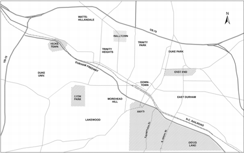
All of the city’s mid-20th-century African-American neighborhoods were situated along the city’s railroads, except for Lyon Park and Walltown, and thus were also proximate to industrial areas. This is not surprising, as much of the African-American population had come to Durham to work in the city’s tobacco factories and textile mills (Anderson, Citation2011). Working-class White residential areas also abutted the city’s railroads, and the city council approved industrial zoning for many residential areas adjacent to the city’s railroads, whether they were White or African American (Durham Department of Public Works, 1937; Durham Zoning Commission, 1926). There were very few requests to either upzone or downzone properties during the Depression and World War II. After the war, with the decline of the tobacco and textile industries, Durham entered a period of economic deceleration relative to other cities in the state. City planning staff blamed a range of problems that included unsightliness and poor physical organization (City of Durham, 1960, p. 6). The city turned aggressively to highway building and urban renewal, razing most of the Hayti neighborhood and increasing trucking access to the city’s central industrial areas.
For much of the 20th century, Durham had a reputation in the South for African-American prosperity (Sindler, Citation1965) and relatively peaceful race relations: Booker T. Washington (1911, p. 647) called Durham’s Whites the “sanest” of southern Whites in their racial attitudes. African Americans did not achieve adequate political representation until the late 20th century, however. In the mid-1960s, although African Americans made up one-third of the city’s population, they represented only a quarter of registered voters (Redburn, Citation1970, p. 49). Durham residents elected all 13 councilmembers on a citywide basis in the 20th century, and citywide elections in the United States have historically hindered minority representation (Welch, Citation1990). This certainly appears to have been the case in Durham: There were no African-American councilmembers until 1953, just one from that year until 1967, and then two from 1967 through 1976. The city’s mayor in the 1960s was a conservative who secured victories with appeals to White fears of African-American empowerment (Redburn, Citation1970). City council membership during the postwar decades was furthermore typical of urban growth machine politics: In 1965, nine councilmembers were connected to the building industry as savings and loan presidents, builders, landlords, bankers, or real estate brokers (Sarratt, Citation1969, p. 4).
Between two and four African Americans served on the council from 1976 through 1984. More consistent and proportional representation for African Americans arrived in the mid-1980s even as at-large council elections continued because a liberal alliance including many African-American politicians was consolidating and gaining power (Anderson, Citation2011). From 1985 through 1990, five African Americans sat on the city council. In 1989, the city elected Councilman Chester L. Jenkins, representing Durham’s multiracial liberal–progressive coalition, as the city’s first African-American mayor. Durham elected an African-American majority to the city council in 1995. In 1998, Durham residents voted in a special election to reduce the number of councilmembers to seven, with three being elected from newly drawn wards. The council has had at least three African-American councilmembers since this went into effect in 2001 (Anderson, Citation2011). Less information is available about the identity of Durham’s planning and zoning commissioners, but it is notable that the commission and council have mostly been on the same page: The council went against the commission’s recommendations in less than 5% of requests for rezonings to or from heavy commercial and industrial use during the period under investigation.
Evaluating Racial and Class Bias in Zoning
To evaluate the existence of racial or class bias in rezonings to and from heavy commercial and industrial land use, I use a mixed-methods approach based on Maantay’s (2001, 2002a, 2002b) work. I assess the contemporary demographics of areas where Durham approved rezonings to and from heavy commercial and industrial zoning categories and perform an empirical analysis of materials informing these decisions. These materials include city council hearing minutes, planning and zoning commission minutes, planning documents, and other primary materials pertinent to these rezonings.
For the years 1945 through 2014, I compiled a list of all approved upzonings (n = 150) to a heavy commercial or industrial zone from any less intense zone, whether that less intense zone was a residential zone or a less intense commercial or industrial zone. For the same years, I also compiled another list of approved downzonings (n = 135) from a heavy commercial or industrial zone to any less-intense zone, whether that less intense zone was a residential zone or a less intense commercial or industrial zone. Counting rezonings does not directly measure the concentration of heavy commercial or industrial zoning or uses in any area because it does not consider the areal extent of land designated for these uses in relation to the extent of land zoned for other uses: Zoning maps reflecting every historical change are not available. The record of how the city council voted on requests for rezoning to and from heavy commercial and industrial land use does, however, provide a way to gauge over time what types of areas planners and local elected officials thought suitable for the expansion or reduction of heavy commercial and industrial land use.
Permitted uses within heavy commercial and industrial zones have changed in the past 70 years. There was no heavy commercial zoning until the 1950s, so I only consider changes to and from industrial zoning categories from any other categories in the earliest years of analysis. Before the 1950s, light industrial zoning was the least intense zone in which many noisy and polluting manufacturers could locate, including manufacturers of asphalt, dyes, cement, plastic, rubber, paint, linoleum, and varnish (City Council of the City of Durham, 1926). From the 1950s onward, heavy commercial zoning (variably called Commercial-4, Heavy Commercial, or Commercial Trades over the years) was the least intense zone in which many potentially unsightly, hazardous, or otherwise undesirable uses (at least in proximity to residential areas) could locate. These have included adult establishments, coal and coke lots, bulk storage of flammable gases and liquids, and garbage dumps and incinerators (City of Durham, 1971, 1980, 1990).
I map the location of each approved upzoning and downzoning using ArcMap software onto a census tract map from the closest decennial census. I group each type of rezoning into seven 10-year time periods (1945–1954, 1955–1964, 1965–1974, 1975–1984, 1985–1994, 1995–2004, and 2005–2014) with a decennial census at the midpoint of each. Then, for each decade, I compare the average percentage of White residents and the average median household income in all Durham census tracts to a) the average percentage of White residents and the average median income in all Durham census tracts weighted by the number of upzonings that happened in each and b) the average percentage of White residents and the average median income in all Durham census tracts weighted by the number of downzonings that happened in each.
I weight these comparison tracts according to the number of upzonings or downzonings that occurred in each so as not, for example, to equate a census tract experiencing one downzoning over 10 years with another experiencing five downzonings over 10 years. I also weight by tract population in calculating all averages so as not to overemphasize rezonings occurring in very-low-population, sparsely settled census tracts vis-à-vis rezonings affecting parcels in more populated communities. All demographic data and census tract maps are from the National Historical Geographic Information System (Minnesota Population Center, 2011).
My first question asks about the characteristics of the areas where planners and local elected officials upzoned to heavy commercial and industrial use and the characteristics of the areas where they downzoned from heavy commercial and industrial use: I thus conduct one-tailed difference of means tests to understand when the demographic characteristics of the citywide average census tract were significantly different from those of the average census tract where upzonings occurred and from those of the average census tract where downzonings occurred. There have been very few average tracts in this segregated city, but comparing the citywide average tract to the average tract where upzonings occurred and to the average tract where downzonings occurred demonstrates whether the areas where these rezonings occurred were relatively more or less White or relatively higher or lower income.
Durham has been a segregated city where one might expect ghettoized areas to receive unfavorable treatment relative to environmentally preferable White areas. It is only a first step therefore to understand the types of areas where upzonings and downzonings occurred. My second question thus asks how the racial and income characteristics of the average census tract where upzonings occurred differ from those of the average census tract where downzonings occurred. I also use one-tailed difference of means tests to perform these comparisons.
The second component of my research is an empirical analysis of city council hearing minutes, planning and zoning commission minutes, planning documents, and other primary materials related to upzonings and downzonings. This analysis shows how the city’s planners and local elected officials handled rezoning cases involving heavy commercial and industrial uses in areas of different racial and class characteristics across time, and it reveals what different communities thought of these rezonings. I use the 1940 U.S. Census, yearbooks, and other sources available through genealogical websites to determine the race of many of the speakers at hearings. I also use a variety of primary and secondary sources to understand broader changes in Durham politics and how these changes may have influenced zoning decisions.
My empirical analysis reveals a growing consciousness of zoning’s impact on the proximity of hazardous uses to residences in the early 1980s. For this reason, I combine data across multiple decades to a) compare the characteristics of the 1945–1984 average census tract where upzonings occurred and the 1945–1984 average census tract where downzonings occurred with the characteristics of the 1945–1984 citywide average census tract, b) compare the characteristics of the 1985–2014 average census tract where upzonings occurred and the 1985–1984 average census tract where downzonings occurred with the characteristics of the 1985–2014 citywide average census tract, c) compare the characteristics of the 1945–1984 census tract where upzonings occurred with the 1945–1984 average census tract where downzonings occurred, and d) compare the characteristics of the 1985–2014 average census tract where upzonings occurred with the 1985–2014 average census tract where downzonings occurred. shows the first and second comparisons, and shows the third and fourth comparisons. These comparisons reveal an earlier period of evident racial bias in zoning matters and a later period in which this bias subsided; this finding corroborates my empirical analysis.
Table 1. Race and median income in the citywide average census tract and in the average census tracts where upzonings and downzonings occurred, 1945–1984 and 1985–2014.
Table 2. Race and median income in the average census tracts where upzonings occurred and in the average census tracts where downzonings occurred, 1945–1984 and 1985–2014.
Rezonings Involving Heavy Commercial and Industrial Land Uses, 1945–1984
From 1945 through 1984, as shown in , the city upzoned land to industrial or heavy commercial use in areas that were significantly less White than average: The average census tract citywide was 63% White, whereas the average census tract where upzonings occurred was 53.9% White. From 1945 through 1984, the city also upzoned land to heavy commercial or industrial use in areas that were far less White than those where it downzoned land from heavy commercial or industrial use: The average census tract where upzonings occurred was 53.9% White, whereas the average census tract where downzonings occurred was 67.3% White. This difference was also statistically significant, as shown in .
There was no statistically significant difference between the median income of the citywide average census tract and the median income of the average census tract where upzonings occurred, as shown in . There was also no statistically significant difference between the median income of the average census tract where upzonings occurred and the median income of the average census tract where downzonings occurred, as is shown in . All together, the quantitative analysis demonstrates that the city disproportionately subjected communities of color to upzonings to heavy commercial and industrial use, whereas White neighborhoods of any income level remained relatively shielded from these upzonings.
This disparity in treatment across the city’s color lines may have resulted from the lack of substantial political representation for African Americans before the mid-1980s: It is notable that upzonings to heavy commercial and industrial use occurred in African-American neighborhoods despite protests against these rezonings. In 1956, the Durham Industrial Development Corporation (DIDCO) requested that the city rezone 60 acres of residentially zoned land southeast of the Hayti for industrial use (Durham City Council Minutes [DCCM] Book Z, February 6, 1956, p. 266). DIDCO had sprung from the Chamber of Commerce’s development efforts in the economically depressed postwar city (Anderson, Citation2011), and the planning and zoning commission supported DIDCO’s request. Residents opposed to the proposed upzoning in this nearly exclusively African-American area pointed out that families were buying homes on adjacent streets and appealed to the city’s duty to protect the “community with its homes, school and churches” (DCCM Book Z, March 5, 1956, p. 312). Their objections only led DIDCO to promise a planted buffer, and the city council voted to upzone the land (DCCM Book Z, April 15, 1956, p. 360). A decade later, a representative of the local Bacon Street Community Organization went before the planning and zoning commission to point out that there were drainage problems on the site, that DIDCO’s presence had “degraded the area,” and that furthermore there were “very few jobs available to Negroes in the industrial complex” (Durham Planning and Zoning Commission, Vol. II, October 17, 1967).
In 1962, a cement company sought to upzone its East End duplex-zoned property to allow a distribution facility. Neighboring residential property owners, many of whom had recently built homes, organized as the East End Betterment League to express concerns about truck traffic hazards for children and to explain that residential construction was ongoing in the area (DCCM Book CC, September 4, 1962, p. 368; DCCM Book CC, September 17, 1962, p. 377). The planning and zoning commission recommended that the council upzone the property while the cement company praised the Chamber of Commerce as having “worked hard to get this industry for Durham…” (DCCM Book CC, September 4, 1962, pp. 367–368). The council agreed with the commission’s recommendation and voted to upzone the property (DCCM Book CC, September 17, 1962, p. 377).
In 1968, planning staff drafted a new zoning ordinance aimed at allowing a greater range of residential building types (DCCM Book GG, December 2, 1968, pp. 387–388). A large number of White East Durham property owners took advantage of the associated reassessment of zoning designations, requesting upzonings to heavy commercial and industrial categories for scores of their residentially zoned properties (DCCM Book GG, January 16, 1969, pp. 452–454). The new Durham Freeway, cutting from downtown eastward through the Hayti, was also driving these requests (Durham City-County Planning Department, 1991). At the time, East Durham was transitioning from a predominantly White to a predominantly African-American area (U.S. Census Bureau, 1963, 1973). One of the representatives for the landowners argued that the area was “blighted” but “if zoned for industrial use, private enterprise would restore it in a very few years” (DCCM Book GG, January 16, 1969, p. 453). Planning staff and planning and zoning commissioners countered the argument that the area was blighted, citing school and housing developments in the vicinity (DCCM Book GG, January 16, 1969, pp. 452–454). The city council for the most part heeded the planners’ points but still approved several upzonings to heavy commercial or industrial use at sites adjacent to existing industrial areas or the new freeway (DCCM Book GG, March 3, 1969, pp. 548–552). The city council also, in this case following a recommendation of the commissioners, upzoned a large White-owned residential parcel for industry in an already majority African-American area just south of the East End neighborhood (DCCM Book GG, January 14, 1969, p. 517; DCCM Book GG, March 3, 1969, p. 552). In the late 1970s and into the 1980s the city continued to upzone many commercial and residential tracts for industry on a piecemeal basis in an increasingly African-American East Durham. The city council may have only been favoring industry’s return to sections of the city where textile mills had long stood vacant. However, the new industries, unlike the mills, employed smaller workforces and were involved in hazardous uses, including chemical storage and manufacture (Durham City-County Planning Department, 1991).
The DIDCO, East End, and East Durham cases exemplify a postwar trend: In the three decades following World War II, the Chamber of Commerce, planning and zoning commission, and city council appear to have been encouraging industrial growth disproportionately in African-American areas. The city council, almost always following commission recommendations, at the same time rejected requests for upzoning to heavy commercial or industrial use in majority White census tracts (rejecting 25 of 50 total requests from 1945 through 1984) more often than they did in majority African-American census tracts (rejecting nine out of 40 total requests from 1945 through 1984).
From 1945 through 1984, as shown in , downzonings occurred in an average census tract that was more White and wealthier than the citywide average tract, although these differences were not statistically significant. However, the average census tract where downzonings occurred was significantly more White than the average tract where upzonings occurred, as shown in . Of the 10 downzonings before 1965, eight were in White neighborhoods. An increasing number of downzonings occurred in communities of color from 1965 through 1984, but not all were truly protective in spirit. During the continued postwar migration of rural African Americans to the cities, builders across the United States exploited overcrowding in existing ghettos and sought further profits by pushing the boundaries of ghettos into depopulating working-class White neighborhoods (Mohl, Citation1995). One notorious Durham slumlord secured a downzoning from heavy commercial and industrial use to the city’s highest density residential category in a majority African-American section of East Durham (DCCM Book KK, February 5, 1973, p. 68). This allowed him to pursue an apartment project, even though African-American civil rights and neighborhood activists had targeted him with complaints of overcrowding, rent gouging, and poor maintenance (Piercy, Citation1968; Sarratt, Citation1969).
The Durham Housing Authority also secured two downzonings in African-American neighborhoods during the 1970s for public housing construction (DCCM Book NN, June 7, 1976, p. 574; DCCM Book OO, November 15, 1976, p. 313). Thus the Housing Authority continued a long-criticized, exploitative, post-desegregation practice, concentrating public housing away from White areas and within low-income African-American neighborhoods (Sarratt, Citation1969). This practice was the result of pressure from the Durham Board of Realtors, which was fiercely opposed to public housing in White areas because it could possibly disrupt property values: The Durham Housing Authority had proposed as many as 14 public housing sites during the 1960s in White areas, but the Board of Realtors’ lobbying prompted the city council to rebuff the Authority each time (Sarratt, Citation1969). Because I can confirm that the city council approved at least a few of the 1945–1984 downzonings in African-American areas to make way for exploitative private and public housing projects, I cannot say that downzonings in African-American areas before 1985 were actually intended to shield communities from undesirable uses. The quantitative evidence on downzonings therefore likely obscures the true disparity in the treatment of White and African-American areas before 1985.
Rezonings Involving Heavy Commercial and Industrial Land Uses, 1985–2014
In the mid-1980s there was a clear and sudden shift away from this disparity in the treatment of White and African-American areas. From 1985 through 2014 there was no statistically significant difference between the racial composition of the average census tract where the city approved upzonings and the racial composition of the citywide average census tract: shows this in contrast with the data from the 1945–1984 period. The average census tract where the city approved downzonings was also, at a statistically significant level, less White than the average census tract where the city approved upzonings: shows this in contrast with the data from the 1945–1984 period.
A 1983 chemical spill at Armageddon Chemical, a manufacturer located in East Durham since 1970, provided a significant catalyst for change (DCCM Book WW, February 4, 1985, pp. 353–358). The spill emitted toxic fumes into residential areas, and the city had to evacuate 15 homes (Andrews, Burby, & Turner, Citation1985). Concerns were not only over safety: A statewide consumer advocacy group called Durham a “dumping ground” and noted that the city’s “property values reflect that history” (North Carolina People’s Alliance, 1983–1985). The spill came 1 year after officials had sited North Carolina’s only chemically secure landfill for contaminated soil in Warren County (Andrews et al., Citation1985), a rural and low-income county with the state’s highest African-American majority (U.S. Census Bureau, 1981) located 50 miles northeast of Durham. The landfill generated a series of protests and lawsuits that scholars came to identify as the beginning of the environmental justice movement (Bullard, Citation1996; Cutter, Citation1995). Following pressure from Citizens for a Safer East Durham and other groups, Durham passed a right-to-know ordinance in 1985 that required businesses to notify neighbors of hazardous materials stored onsite (Andrews et al., Citation1985).
Armageddon Chemical closed by the spring of 1985 (Andrews et al., Citation1985), but the danger from other hazardous uses in East Durham remained, and residents began to demand that planners and the city council address the concentration of hazardous uses in their neighborhoods (DCCM Book XX, September 23, 1985, pp. 285–292). In 1986, another chemical plant fire resulted in the evacuation of 600 families (Durham City-County Planning Department, 1995, p. 15). Residents in Southeast Durham meanwhile pressured the owner of 11 acres zoned for heavy industry to donate the land to the city for a park; African-American Councilman Chester L. Jenkins praised the activists as “not afraid to get out and fight for what they believe in” (DCCM Book AAA, March 21, 1988, p. 259).
The city’s 1989 East Central Durham plan area study revealed that 12 industrial accidents had occurred over the previous 5 years (Durham City-County Planning Department, 1991). In September 1989 the city council unanimously voted to downzone 130 acres of heavy industrial property for light industrial use in East Durham, in a victory for petitioning African-American East Durham neighborhood safety activists and allied neighborhood organizations from across the city. This followed hearings in which the Chamber of Commerce and other business interests stood opposed to the downzoning, and Jenkins and other African-American councilmembers argued that fears over safety trumped concerns for jobs lost (DCCM Book BBB, September 19, 1988, pp. 21–34).
This downzoning signified that the city’s attitude toward zoning in East and Southeast Durham’s communities of color was changing in the 1980s, undoing some of the piecemeal upzoning for industry that had occurred in these areas only a decade earlier. Some of the change likely had to do with the growing power of African Americans in city government, but communities of color now also had White allies in their planning and zoning concerns and not only in regard to heavy commercial and industrial uses. One White councilman, commenting on a 1984 rezoning request to allow a gas station in East Durham, stated, “East Durham has traditionally been the catch-all place for everything…that we didn’t want to have in [the two White neighborhoods of] Trinity Park or Hope Valley.… This is just another example of allowing the neighborhood to erode” (DCCM Book VV, January 3, 1984, p. 118).
In the early 1990s, downzonings in Durham’s communities of color became more significant, redesignating many East Durham parcels from heavy commercial and industrial to light commercial or residential categories (DCCM, May 18, 1992, pp. 27–28; DCCM, September 21, 1992, p. 21; DCCM, March 1, 1993, p. 18; DCCM, October 24, 1994, pp. 22). In the West Durham African-American enclave of Walltown, activists defeated rezonings of residential property, arguing that “houses and apartments provided for low-income families are often taken for granted and even placed at substantial risk by inappropriate zoning and commercial intrusion” (DCCM Book CCC, August 20, 1990, p. 458). A 1995 plan for Southeast Durham noted “concern over the serious harm that the general public might suffer as a result of the use, storage, transportation and disposal of hazardous materials” and recommended downzoning all land zoned for heavy industry in the area (Durham City-County Planning Department, 1995, p. 15). The city council did not end up targeting heavy industry in the area, instead downzoning light industrial properties for less intense uses in the late 1990s (DCCM, September 18, 1995, p. 24; DCCM, October 20, 1997, p. 17; DCCM, November 17, 1997, pp. 21–23; DCCM, May 17, 1999, pp. 25–26).
The remaining heavy industrial properties set the stage for another major environmental justice fight in the early 2000s when planning staff, at the behest of a local asphalt business and Durham’s economic development director, recommended reducing buffer requirements for asphalt manufacturing (Strom, 2002). These requirements, in place since the 1980s because of the series of industrial accidents in the area, had effectively banned new asphalt manufacturing businesses because so many residential areas were proximate to parcels zoned for heavy industry (Hails, 2001). NAACP activists immediately framed the proposal as an environmental justice issue because almost all of the sites made available by the proposed action were located in East and Southeast Durham (Strom, 2002). Residents made clear their preferences for safety over a “handful of jobs” (Marchan, 2002). The city council ultimately rejected the proposal to reduce buffers for asphalt plants (Schelp, Citation2002). Indeed, the argument that the future of communities of color depended on industry’s rebirth seemed generally out of favor: Proponents of one downzoning argued that supplanting industrial zoning could open the way for less intensive commercial ventures that would also create jobs (DCCM, February 7, 2000, p. 27). Planners argued that industrial zoning allowed the proliferation of junkyards, consequently restraining economic development (Neighborhood Concepts, 2003).
After 1984, as shown in , there was no statistically significant difference between the racial composition of the average census tract where downzonings occurred and that of the citywide average census tract. Median income, however, was significantly lower in the average tract where downzonings occurred than in the citywide average tract. Many downzonings have occurred within communities of color since the 1980s (since 2000 a growing Hispanic presence has characterized these communities), but a large number have also occurred within low-income White communities in the urban core. The driving factor behind many of these downzonings is not concern over hazardous uses proximate to residences, but instead the city’s desire for residential and commercial redevelopment of disused industrial land. In the past few decades, many downzonings have allowed developers to convert long-abandoned factories and warehouses to loft apartments and upmarket commercial areas symbolizing today’s gentrifying urban core (DCCM Book SS, January 14, 1980, p. 140; DCCM Book VV, July 24, 1984, pp. 580–581; DCCM, July 15, 1996, pp. 15–16; DCCM, August 16, 2002, p. 24; DCCM, May 3, 2004, p. 30).
The plethora of downzonings across the city in recent decades has also reflected the efforts of new arrivals to restore the city’s streetcar bungalow districts; the new arrivals have been effective at targeting the city’s assumption that lenient zoning attracts investment (DCCM Book ZZ, July 27, 1987, p. 309). Thus, gentrification within both African-American and White areas likely explains why, from 1985 through 2014, downzonings occurred in an average tract that was significantly lower income than average but not significantly less White than average.
Racial and Class Bias in Zoning
This research reveals noteworthy answers to the questions I pose in the introduction to this article on the racial and income characteristics of areas upzoned to and downzoned from heavy commercial and industrial use, the difference between the characteristics of these two types of areas, and the impacts of the empowerment of communities of color on any evident bias in these upzonings and downzonings. To answer these questions, I use quantitative evidence derived from the record of these zoning decisions as well as an empirical analysis of materials informing these decisions.
Before the mid-1980s, Durham’s city council upzoned for heavy commercial and industrial uses in an average tract that was significantly less White than both the citywide average tract and the average tract where downzonings occurred. Before 1985, there was no statistically significant difference between the median income in the average census tract where upzonings occurred and the median income in the average census tract where downzonings occurred or between the median income in the average citywide census tract and the median incomes in the average tracts where upzonings or downzonings occurred. The disparity between the areas where the city approved upzonings and the areas where the city approved downzonings was thus, before 1985, conclusively a racial one. The qualitative evidence supports this: It demonstrates that before 1985, the city’s overwhelmingly White city council ignored activism against upzonings in African-American communities and more often blocked upzonings in White neighborhoods. Downzonings did occur in communities of color before 1985, but the city approved some of them to allow exploitative private and public sector housing projects to proceed: The actual gulf between the city’s treatment of White and African-American areas is thus likely understated by the quantitative evidence.
After 1985, there was no statistically significant difference between the racial composition of the citywide average census tract and the average census tract where upzonings took place. In addition, downzonings took place in an average census tract that was less White, at a statistically significant level, than the average census tract where upzonings occurred. This is likely due to increased African-American representation in the city council during the 1980s and a local environmental justice movement that developed following a series of industrial incidents in African-American neighborhoods. A more racially diverse city council took heed of this activism, approving downzonings and other reforms. The average census tract targeted for downzonings over the past 30 years has also had a significantly below-average median income. Downzonings over the past 30 years reflect the local environmental justice movement, but they also reflect redevelopment and gentrification within lower-income White and African-American areas alike.
This history indicates that race historically played a role in zoning for heavy commercial and industrial uses and thus supports the idea promoted in the environmental justice literature that planners and local elected officials have approached zoning differently in White communities and communities of color, leading to the degradation of communities of color. Given the record of repeated negative consequences for African-American residential areas in Durham from a variety of industries, it is likely that past zoning practice impeded the ability of Durham’s households of color to gain equity through property investments and contributed to health hazards in their neighborhoods. African-American empowerment, a series of industrial accidents, and then gentrification changed the nature of zoning practice in Durham after the mid-1980s. These events may be unique to Durham, so one may not expect to see such a reversal of conventional practices in many other locations.
This history is crucial for scholars and planners to explore elsewhere: To promote equity, planners need to implement zoning for the health, safety, and welfare of all the public and also to pay special attention to historically victimized communities. Durham’s history demonstrates that planners and local elected officials can successfully intervene to end inequitable disparities in zoning practice. Assessments of past zoning practices such as the one I present here may reveal historical or contemporary disparities in zoning practice across racial or class boundaries in other cities and can help planners in those cities present a case for corrective action.
Note
Acknowledgments
I would like to acknowledge T. W. Lester of the Department of City and Regional Planning at the University of North Carolina at Chapel Hill, Lisa K. Bates of the Department of Urban Studies and Planning at Portland State University, Lynn Richardson of the Durham County Library, and D. Ann Gray and the entire staff of the Durham City Clerk’s Office.
Additional information
Notes on contributors
Andrew H. Whittemore
Andrew H. Whittemore, AICP ([email protected]), is an assistant professor of city and regional planning at the University of North Carolina at Chapel Hill and serves on the planning board of Carrboro (NC).
Notes
1. Southern cities undertook so-called racial zoning as late as the 1940s despite a 1917 U.S. Supreme Court ruling that it was unconstitutional (Buchanan v. Warley, 1917). Racial zoning is the zoning of households’ places of residence according to their race and should not be confused with land use zoning: The former directly zones users, whereas the latter zones uses, though with implications for users of many different characteristics, including race (see Silver, Citation1991).
References
- Abrams, C. (1966). The housing problem and the negro. Daedalus, 95(1), 64–76. Retrieved from http://www.jstor.org/stable/20026967
- Anderson, J. B. (2011). Durham County: A history of Durham County, North Carolina. Durham, NC: Duke University Press.
- Andrews, R. N., Burby, R., & Turner, A. G. (1985). Hazardous materials in North Carolina: A guide for decisionmakers in local government. Retrieved from http://infohouse.p2ric.org/ref/17/16896.pdf
- Arlington Heights v. Metropolitan Housing Development, 429 U.S. 252 (1977).
- Arnold, C. A. (1998). Planning milagros: Environmental justice and land use regulation. Denver University Law Review, 76(1), 1–155.
- Arnold, C. A. (2007). Fair and healthy land use: Environmental justice and planning. Chicago, IL: American Planning Association.
- Bolin, B., Grineski, S., & Collins, T. (2005). The geography of despair: Environmental racism and the making of South Phoenix, Arizona, USA. Human Ecology Review, 12(2), 156–168. Retrieved from http://trangwww.humanecologyreview.org/pastissues/her122/bolingrineskicollins.pdf
- Brown, C. R. (1985). Durham’s early twentieth-century suburban neighborhoods. In C. W.Bishir & L. S.Early (Eds.), Early twentieth-century suburbs in North Carolina: Essays on history, architecture and planning (pp. 39–47). Raleigh: North Carolina Department of Cultural Resources.
- Buchanan v. Warley, 245 U.S. 60 (1917).
- Bullard, R. D. (1996). Environmental justice for all. In R. D.Bullard & J.Lewis (Eds.), Environmental justice and communities of color (pp. 3–22). San Francisco, CA: Sierra Club Books.
- Bullard, R. D. (2000). Dumping in Dixie: Race, class, and environmental quality (3rd ed.). Boulder, CO: Westview Press.
- City Council of the City of Durham. (1926). Zoning ordinance. Durham, NC: Author. Durham County Library, North Carolina Collection.
- City of Durham. (1960). Land use plan 1960–1980. Durham, NC: Department of Planning. University of North Carolina at Chapel Hill, North Carolina Collection.
- City of Durham. (1971). Zoning ordinance. Effective March 11, 1969, revised through March 8, 1971. Durham, NC: Author. Durham County Library, North Carolina Collection.
- City of Durham. (1980). Zoning ordinance. Effective March 11, 1969, revised through July 15, 1980. Durham, NC: Author. Durham County Library, North Carolina Collection.
- City of Durham. (1990). Zoning ordinance. Effective March 11, 1969, revised through July 23, 1990. Durham, NC: Author. Durham County Library, North Carolina Collection.
- Colquette, K. M., & Robertson, E. A. H. (1991). Environmental racism: The causes, consequences, and commendations. Tulane Environmental Law Journal, 5(1), 153–207.
- Connerly, C. E. (2005). “The most segregated city in America”: City planning and civil rights in Birmingham, 1920–1980. Charlottesville: University of Virginia Press.
- Cutter, S. L. (1995). Race, class, and environmental justice. Progress in Human Geography, 19(1), 111–122. doi:10.1177/030913259501900111
- De Vor, F., & De Groot, H. L. (2011). The impact of industrial sites on residential property values: A hedonic pricing analysis from The Netherlands. Regional Studies, 45(5), 609–623. doi:10.1080/00343401003601925
- Dubin, J. C. (1992). From junkyards to gentrification: Explicating a right to protective zoning in low-income communities of color. Minnesota Law Review, 77(4), 739–801.
- Durham City Council Minutes. [Years through 1996 available in Durham’s Office of the City Clerk; years 1997–2014 retrieved fromhttp://durhamnc.gov/DocumentCenter]
- Durham City-County Planning Department. (1991). East central Durham plan. Durham, NC: Author. Durham County Library, North Carolina Collection.
- Durham City-County Planning Department. (1995). South central Durham plan. Durham, NC: Author. Durham County Library, North Carolina Collection.
- Durham Department of Public Works. (1937). Durham, North Carolina. Durham, NC: Author. Government Documents, Perkins Library, Duke University.
- Durham Planning and Zoning Commission. Minutes. Vol. I, January19, 1949–December18, 1962; Vol. II, February 19, 1963–December 19, 1969. Available at the Durham City-County Planning Department.
- Durham Zoning Commission. (1926). Building zone map of Durham, North Carolina. Durham, NC: Author. University of North Carolina at Chapel Hill, North Carolina Maps Collection.
- Greenberger, S. S. (1997, July 21). A legacy of zoning bias: East Austinites seek to reform land use rules of 1931. The Austin-American Statesman, p. A1.
- Haggerty, M. (1996). Crisis at Indian Creek. In R.Bullard (Ed.), Unequal protection: Environmental justice and communities of color (pp. 23–42). San Francisco, CA: Sierra Club Books.
- Hails, D. (2001, July 31). Memo to members of the zoning committee. John Schelp Papers Box 1, “Asphalt Plant battle,” Durham County Library, North Carolina Collection.
- Hanchett, T. W. (1998). Sorting out the new south city: Race, class, and urban development in Charlotte 1875–1975. Chapel Hill: University of North Carolina Press.
- Hinds, D. S., & Ordway, N. (1986). The influence of race on rezoning decisions: Equality of treatment in Black and White census tracts, 1955–1980. The Review of Black Political Economy, 14(4), 51–63. doi:10.1007/BF02903791
- Hirt, S. (2015). Zoned in the USA: The origins and implications of American land-use regulation. Ithaca, NY: Cornell University Press.
- Logan, J. R., & Molotch, H. L. (1989). Urban fortunes: The political economy of place. Berkeley: University of California Press.
- Maantay, J. (2001). Zoning, equity, and public health. American Journal of Public Health, 91(7), 1033–1041. Retrieved from https://www.ncbi.nlm.nih.gov/pmc/articles/PMC1446712/pdf/11441726.pdf
- Maantay, J. (2002a). Industrial zoning changes in New York City: A case study of “expulsive” zoning. Projections: The MIT Journal of Planning, 3, 63–108. Retrieved from http://web.mit.edu/dusp/dusp_extension_unsec/news/Projections-3.pdf
- Maantay, J. (2002b). Zoning law, health, and environmental justice: What’s the connection? Journal of Law, Medicine & Ethics, 30(4), 572–593. doi:10.1111/j.1748-720X.2002.tb00427.x
- Marchan, R. (2002, February). Asphalt plants and jobs. John Schelp Papers Box 1, “Asphalt Plant battle,” Durham County Library, North Carolina Collection.
- Minnesota Population Center. (2011). National Historical Geographic Information System: Version 2.0. Minneapolis: University of Minnesota.
- Mohl, R. A. (1995). Making the second ghetto in metropolitan Miami, 1940–1960. Journal of Urban History, 21(3), 395–427. doi:10.1177/009614429502100305
- Morello-Frosch, R., & Jesdale, B. M. (2006). Separate and unequal: Residential segregation and estimated cancer risks associated with ambient air toxics in U.S. metropolitan areas. Environmental Health Perspectives, 114(3), 386–393. doi:10.1289/ehp.8500
- Neighborhood Concepts. (2003). Northeast central Durham strategic revitalization plan. Durham, NC: Author. Durham County Library, North Carolina Collection.
- North Carolina People’s Alliance. (1983–1985). Summary of proposed legislation. Durham People’s Alliance Records, Box 33, “Toxic Materials/Hazardous Waste,” Durham County Library, North Carolina Collection.
- Novotny, P. (1998). Popular epidemiology and the struggle for community health in the environmental justice movement. In D.Faber (Ed.), The struggle for ecological democracy (pp. 137–158). New York, NY: Guilford Press.
- Payne-Sturges, D. C., & Gee, G. C. (2006). National environmental health measures for minority and low-income populations: Tracking social disparities in environmental health. Environmental Research, 102(2), 154–171. doi:10.1016/j.envres.2006.05.014
- Piercy, D. (1968). Greenberg housing controversy: A case study in community organization. North Carolina Fund Collection, Southern Historical Collection, University of North Carolina Collection 04710, Subseries 6.7 folder 7120.
- Pulido, L. (2000). Rethinking environmental racism: White privilege and urban development in Southern California. Annals of the Association of American Geographers, 90(1), 12–40. doi:10.1111/0004-5608.00182
- Pulido, L., Sidawi, S., & Vos, R. O. (1996). An archaeology of environmental racism in Los Angeles. Urban Geography, 17(5), 419–439. doi:10.2747/0272-3638.17.5.419
- Rabin, Y. (1989). Expulsive zoning: The inequitable legacy of Euclid. In C. M.Haar & J. S.Kayden (Eds.), Zoning and the American dream: Promises still to keep (pp. 101–121). Chicago, IL: American Planning Association.
- Redburn, F. S. (1970). Protest and policy in Durham, North Carolina (Doctoral dissertation). Available from ProQuest Dissertations and Theses database. (Order No. 302550669)
- Sarratt, J. (1969). Public housing in Durham, North Carolina: Racial confrontation in the new south. Political Science Honors Essays: University of North Carolina. North Carolina Collection, University of North Carolina at Chapel Hill.
- Schelp, J. (2002). Victory for Durham: Asphalt measure is killed. John Schelp Papers Box 1, “Asphalt Plant battle,” Durham County Library, North Carolina Collection.
- Sidawi, S. (1997). Planning environmental racism: The construction of the industrial suburban ideal in Los Angeles County in the early twentieth century. Historical Geography, 25(1–2), 83–99.
- Silver, C. (1991). The racial origins of zoning in American cities: Southern cities from 1910–1940. Planning Perspectives, 6(2), 189–205. doi:10.1080/02665439108725726
- Sindler, A. P. (1965). Negro protest and local politics in Durham, NC. New York, NY: McGraw-Hill.
- Smith, H. H. (1983). The citizen’s guide to zoning. Washington, DC: American Planning Association.
- Strom, J. (2002, February 20–26). Paving the way. Independent Weekly, pp. 17–18.
- Sze, J. (2007). Noxious New York: The racial politics of urban health and environmental justice. Cambridge, MA: MIT Press.
- Taylor, D. E. (2014). Toxic communities: Environmental racism, industrial pollution, and residential mobility. New York, NY: New York University Press.
- U.S. Census Bureau. (1952). 1950 census of population and housing. Washington, DC: Government Printing Office.
- U.S. Census Bureau. (1963). 1960 census of population and housing. Washington, DC: Government Printing Office.
- U.S. Census Bureau. (1973). 1970 census of population and housing. Washington, DC: Government Printing Office.
- U.S. Census Bureau. (1981). 1980 census of population and housing. Washington, DC: Government Printing Office.
- U.S. Census Bureau. (1990). 1990 census of population and housing. Washington, DC: Government Printing Office.
- U.S. Census Bureau. (2012). 2010 census of population and housing. Washington, DC: Government Printing Office.
- Village of Euclid v. Ambler Realty Co., 272 U.S. 365 (1926).
- Washington, B. T. (1911, March 23). Durham, North Carolina, a city of negro enterprises. The Independent, pp. 642–650.
- Welch, S. (1990). The impact of at-large elections on the representation of Blacks and Hispanics. Journal of Politics, 52(4), 1050–1076. doi:10.2307/2131682
- Young, L. C. (2004). Breaking the color line: Zoning and opportunity in America’s metropolitan areas. Journal of Gender, Race and Justice, 8(3), 667–710.