
Abstract
The construction of the Rogun Dam in the Amu Darya Basin to increase upstream energy generation creates potential trade-offs with existing downstream irrigation, due to the different timing of energy and irrigation water demands. The present analysis, based on a hydro-economic optimization model, shows that cooperative basin-wide maximization of benefits would lead to large increases in upstream hydropower production and only minor changes in downstream irrigation benefits. However, if upstream stations, including Rogun, are managed unilaterally to maximize energy production, hydropower benefits might more than double while irrigation benefits greatly decrease, thereby substantially reducing overall basin benefits.
Introduction
Achieving water, food and energy security in the context of increasing population and economic development is a key global challenge facing societies in many countries today. Complicating this challenge is the high degree of interconnection across the water, food and energy sectors, as evidenced by the high degree of correlation of food and energy prices and the strong dependence of food production on water availability (Ringler, Bhaduri, & Lawford, Citation2013). Irrigation is responsible for 70% of global freshwater withdrawals and is used to generate 40% of global food (Molden, Citation2007; Rosegrant, Ringler, & Zhu, Citation2009), while hydropower contributes 16% of the global supply of electricity (Lucky, Citation2012). Despite these and other interlinkages (e.g. energy input to agriculture), planning in the food and energy production sectors is typically uncoordinated. Moreover, management of these sectors involves various specialized institutions, with disparate government agencies providing regulation. Meeting national water, energy and food needs might also require imports of some or all of these resources from neighbouring countries or faraway places, often with differing strategic interests.
Integrated management and planning of these sectors can be an important means to increase the benefits of resource use and thus improve livelihoods where water, food and energy resources are scarce. One tool to support such an integrated approach is the river basin hydro-economic model (HEM), which links water users across space and time (Harou et al., Citation2009; Ringler, von Braun, & Rosegrant, Citation2004; Rosegrant et al., Citation2000; Wu, Jeuland, Whittington, & Sadoff, Citation2013). Hydro-economic and other, similar systems planning models allow analysis of (a) the effects of current policies and trade-offs across diverse competing uses for water resources; (b) future changes in infrastructure or institutions governing water allocation; and (c) vulnerabilities to future hydrological or other changes that affect water supply and demand.
This article develops and applies an integrated approach to the second of these issues, via assessment of a controversial infrastructure project in the Aral Sea basin, a transboundary river basin in Central Asia (Eshchanov, Stultjes, Salaev, & Eshchanov, Citation2011). The Rogun Dam, on the Vakhsh tributary of the Amu Darya River in Tajikistan, is principally a hydropower project. The project has a long history. Construction was first initiated in 1976, but progress slowed and the project was eventually suspended due to the collapse of the Soviet Union. Since 1991, a series of disagreements, first with Russia and then with other basin riparians, have effectively blocked financing for the project. Recently, the World Bank conducted a four-year analysis of the feasibility of Rogun that assessed the technical, economic, environmental and social aspects of the project (Hashimova, Citation2014; World Bank, Citation2014). The results may help further develop the plans for financing and construction of the project, should other riparians agree to it.
Even when designed with a single purpose, such as hydropower, dams such as Rogun can serve a variety of purposes and have a wide range of positive and negative impacts. Water storage projects can provide water for irrigation or other downstream uses at times of the year when water is scarce or during prolonged drought, produce electricity when water is released through hydropower turbines, and allow smoothing of flows to mitigate floods or ensure minimum supply to maintain ecosystem services. Contrarily, dam operations can reduce downstream water availability during part of the year or disrupt existing and sensitive hydrological processes. A socially optimal regime of water releases from control infrastructures may not always preserve critical benefits for all riparian water users, and may require a balancing of efficiency with equity across multiple affected parties. In this sense, the Rogun Dam proposal raises important questions that relate to its potential impacts on the water, food and energy security of the major Amu Darya riparians.
Although hydropower generation does not entail consumptive water use, except insofar as storage increases evaporation and unrecoverable seepage losses from reservoirs, it may alter the seasonal pattern of water releases in the Aral Sea basin in significant ways, with implications for downstream users (O’Hara, Citation2000; Wegerich, Citation2008). In the Amu Darya system, downstream irrigation, which is mainly located in Uzbekistan and Turkmenistan, requires sufficient delivery of water – and therefore releases from storage – in summer. In contrast, hydropower generation and releases are most beneficial in winter, when energy demand is high. Upstream countries tend to argue for increasing energy production while also suggesting that storage provides downstream gains in dry years when water supplies are lacking (Bank Information Center, Citation2013). Downstream countries meanwhile contend that irrigation water availability during the critical summer season is curtailed by operating rules that fill reservoirs during summer months to allow for greater release for energy generation in the winter, and that such releases cause flooding and infrastructure damage downstream (Bank Information Center, Citation2013; Spoor & Krutov, Citation2003). The seismic risks of construction of very high dams in this zone have been also emphasized (Bank Information Center, Citation2013; Eshchanov et al., Citation2011).
This study starts with a brief description of the study area and of the HEM used to analyze the possible effects of the Rogun Dam. We then present the results of the modelling analysis, prior to discussing them as well as other relevant issues – namely the seismic and political risks of construction of this dam. The article concludes with additional remarks and policy implications.
A hydro-economic basin management model of the Aral Sea basin
A brief description of the study area
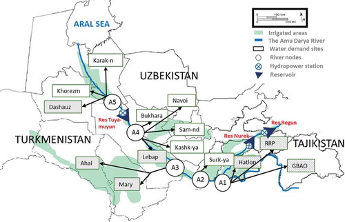
The territory of the Amu Darya catchment (), which is part of the larger Aral Sea basin, is characterized by a diversity of natural landscapes including mountains, valleys, deserts, lakes and rivers (Bekchanov, Citation2014). The Amu Darya is the largest river in Central Asia, with a catchment area of 309,000 km2 and annual average flow of 73 km3 (Bekchanov, Citation2014, p. 31). The river system flows 2574 km from the headwaters of the Pyanj River on the Afghan–Tajik border to the Aral Sea (Central Asian Research Institute of Irrigation [SANIIRI], Citation2004), and its catchment lies in four countries: Tajikistan, Uzbekistan, Turkmenistan and Afghanistan (McKinney, Citation2004).
Figure 1. Amu Darya River basin scheme. Locations in Turkmenistan are in boxes with grey background, those of Uzbekistan have a white background, and for Tajikistan with mixed pattern.
The basin has a distinctly continental climate (UNEP, Citation2005), with precipitation occurring mainly during the winter in the form of snow, and during spring rains, thus outside of the annual growing season. Snow and glacier melt however provide the majority of river flows. Thus, historical discharges were minimal in winter and peaked during the summer growing season. In addition, given the hot summers and the lack of substantial summer rainfall, net evapotranspiration during the growing season is high. Thus, many parts of the basin, especially towards the downstream end of the system, require irrigation to sustain crop cultivation. Groundwater sources contribute about 3–4% of total irrigation water consumption.
Irrigated agriculture and rural settlements emerged over the centuries along the banks of the Amu Darya (Tolstov, Citation2005). The dominance of this rural agrarian lifestyle has largely been retained to the present day, and over 60% of the population continue to derive their livelihoods from agricultural activities, primarily producing cotton, wheat, rice, fruit and vegetables (Bekchanov, Lamers, & Martius, Citation2010). During the Soviet era, the USSR added to the importance of agriculture in the region by making large investments in upstream water control and in expansion of downstream irrigated agriculture; these investments were mostly geared towards expansion of cotton production (Dukhovny & de Schutter, Citation2011; Micklin, Citation2007). Irrigation expansion led to the gradual desiccation of the Aral Sea as well as saline tail-end depressions beyond irrigation sites, such as in Sarykamysh. Today, agriculture continues to play a key role in the regional economy via its contribution to incomes and employment (Bekchanov & Bhaduri, Citation2013), but might well be adversely affected by increasing development of the river’s hydropower potential (Wegerich, Olsson, & Froebrich, Citation2007; Weinthal, Citation2001). Since the dissolution of Soviet rule in Central Asia, there have been reports of water being insufficient for the demands of downstream irrigators, suggesting that upstream developments may be affecting the availability of irrigation water (Micklin, Citation2007; O’Hara, Citation2000).
Building on these observations, this study develops an HEM for the purpose of analyzing the possible agricultural and hydropower production impacts of the Rogun Dam. If the dam is built to full scale, it will have an energy production capacity of 3600 MW (Eurasian Development Bank [EADB], Citation2008), and at 335 metres it will be the tallest dam in the world (Schmidt, Zambaga-Schulz, & Seibitz, Citation2006; World Bank, Citation2014).
The hydro-economic model
A range of approaches (e.g. input-output, computable general equilibrium, and node-link-based river basin simulation or optimization models) can be found in previous work analyzing the impacts of planned dams (Jeuland, Harshadeep, Escurra, Blackmore, & Sadoff, Citation2013; Jeuland & Whittington, Citation2014; Malik, Citation2007; Robinson & Gueneau, Citation2014; Strzepek, Yohe, Tol, & Rosegrant, Citation2008). This article develops a node-link-based optimization approach, since this approach is particularly useful for analyzing potential trade-offs between water uses across economic sectors and for determining the socially optimal patterns of water releases from existing and new dams (Chatterjee, Howitt, & Sexton, Citation1998; Harou et al., Citation2009). Node-link-based optimization models allow a detailed spatial representation of the hydrological regime and of the water demand relationships of different economic sectors, such as irrigated agriculture, hydropower production, industries and the domestic sector, as well as environmental impacts (Cai, McKinney, & Rosegrant, Citation2003; Ringler et al., Citation2004; Rosegrant et al., Citation2000). They also have important limitations. In particular, optimization models generally assume perfect foresight of future hydrology, and thus may overstate benefits relative to what is achievable in real-world operations. Even so, such HEMs do provide a starting point for comparison of the potential efficiency of different water allocation alternatives and mechanisms (Booker & Young, Citation1994), and of the benefits of greater water cooperation and/or coordination (Jeuland, Baker, Bartlett, & Lacombe, Citation2014; Whittington, Wu, & Sadoff, Citation2005; Ringler et al., Citation2004).
For this study, an HEM was developed that considers the distinct features of the Amu Darya Basin. Given the prevailing land and water allocation distortions that exist in this basin (Anderson, Citation2009) and preclude calibration of existing uses based on the equimarginal principle, a normative programming approach was applied to run and solve the model. As with many similar applications in the literature, the model operates on a monthly time step over the course of a year. The model was coded in GAMS and solved using the CONOPT 3 solver (Brooke, Kendrick, Meeruas, & Raman, Citation2006). The next subsections provide additional details on the model set-up and analysis, specifically the basin schematic, objective function, model constraints, data sources for parameterization, and scenario analyses discussed in this article.Footnote1
River basin schematic
The basic schematic of the model used for analyzing water allocation in the Amu Darya Basin considers inflows from 13 major tributaries, water diversions from 5 river nodes to 14 irrigated areas, and 3 reservoirs and hydropower production stations, including the Rogun Dam (). Although several other, smaller reservoirs exist or are in the planning stages, most of these are temporary off-river storage reservoirs that are filled by pumping and used mainly to facilitate delivery of irrigation water. Since these smaller structures have little impact on monthly flows, they are not included in the model, which only contains the largest and most important reservoirs.
Since irrigation uses more than 90% of total water consumption in the Amu Darya Basin and because the temporal pattern of irrigation water availability is potentially affected by upstream hydropower production developments, we considered these two main economic sectors in the model. Because of the large impact of irrigation expansion on environmental systems in this region, environmental flow benefits were also included. Finally, because the municipal and industrial sectors use less than 10% of total water consumption and are prioritized over other sectors in water allocation decisions, the model imposes fixed water consumption by these sectors.
Model objective function
The objective of the model is to optimize the sum of basin-wide benefits (π) from irrigation () at agricultural demand sites (
), hydropower production (
) at power production stations (
), and environmental benefits (
):Footnote2
Irrigation benefits
Irrigation benefits (in USD millions) are calculated as the difference between total crop production revenues and the costs of crop production, water delivery, return water use, and groundwater pumping:
Crop yield levels are modelled using the FAO method, which seeks to account for seasonal and overall water scarcity. Specifically, yield depends on maximum attainable yields () and the real yield rate (
), which is dimensionless and varies between 0.1 and 1; and
This real yield rate is a function of the fraction of deficits relative to the ideal crop water requirement (Cai, Ringler, & Rosegrant, Citation2006; Ringler et al., Citation2004).Footnote3 Specifically, is related to the maximum crop growth stage deficit (
) as:
The maximum stage deficit is obtained from the set of monthly stage deficits (), which are estimated following Doorenbos and Kassam (Citation1979; see also Ringler et al., Citation2004):
The real yield rate () cannot be larger than the seasonal relative crop yield (
):
Seasonal relative crop yield () is defined based on the FAO formula (Doorenbos & Kassam, Citation1979; Ringler et al., Citation2004), which includes the seasonal crop coefficient (
):
Hydropower benefits
The second component of benefits, from hydropower generation (in USD millions), is calculated as:
Electricity production for the stations () located at the outlet of reservoirs (
) is modelled as a multiplicative function of production efficiency, water elevation, and release through the turbines:
Similarly, hydroelectricity generation at run-of-river power stations is estimated as:
Environmental benefits
The third component of benefits in the objective function corresponds to the economic value of inflows into the Aral Sea and deltaic zones (). Following Bekchanov (Citation2014), these benefits are considered as a linear function of the total monthly environmental flows to the downstream end of the system (
):
Model constraints
Flow continuity constraints
The model is solved subject to a range of water-balance constraints imposed at each river node (Equation (13)) and reservoir (Equation (14)):
All terms are defined similarly in Equation (14). In addition, is reservoir storage volume at the end of month t, RRSrev_up,rev,t is flow to a downstream reservoir (rev) from an upper reservoir (rev_up); evaprrev,t is the rate of evaporation from the surface of the reservoir (in mm); and Srev,t is the surface area of the reservoir (in million m2).
Reservoir morphological parameters
The surface area of the reservoir at time t is estimated using a cubic function:
Other constraints
Other model constraints limit the reservoir storage, hydropower production according to installed generation capacity, and irrigated area according to available irrigable land. To prevent unjustified use of stored water, e.g. to avoid ‘stealing water from the future’, initial levels of all reservoirs are forced to equal the levels at the end of the planning period. Finally, there are constraints on the total volume of return flows that can be reused, since irrigators in the basin resist use of such water (with high salinity) beyond a certain point.
Database of the model
In order to parameterize the model over such a large study area spanning several countries, a consistent database had to be assembled using multiple sources.Footnote5 Monthly water flows to supply nodes; irrigation water withdrawals, cropping patterns and yields; and industrial and municipal demands were obtained from the CAREWIB database (Scientific-Information Center of Interstate Commission of Water Coordination in the Aral Sea Basin [SIC-ICWC], Citation2011).
Data on potential crop evapotranspiration coefficients and effective rainfall were sourced from IFPRI’s IMPACT model (Citation2013). Crop production costs and prices for agricultural areas in the model were specified using data from Uzbekistan, obtained from a range of reports from local water management organizations (Scientific-Information Center of Interstate Commission of Water Coordination in the Aral Sea Basin [SIC-ICWC], Citation2008), as well as surveys (ZEF/UNESCO Uzbekistan Project). All prices were adjusted to 2006 levels (the year corresponding to most of the data used in the model). Conveyance costs across the sites come from the Ministry of Agriculture and Water Resources of Uzbekistan (MAWR, Citation2007). To avoid systematic bias due to policy distortions that affect input and output prices differently across countries, the data from the closest regions in Uzbekistan were applied to agricultural areas in the other countries.Footnote6 The price differences across different regions of Uzbekistan stem from quality differentiation and variable access to markets, rather than differences in policies. For example, farmers in Surkhandarya Province are paid higher prices per unit of cotton because the quality of cotton produced in this region is higher than in other regions.
Electric production capacity, electricity prices, and reservoir storage capacity and releases are based on Cai (Citation1999) and the BEAM and ASBOM model databases (Executive Committee of International Fund for Saving the Aral Sea [EC IFAS], Citation2013; Scientific-Information Center of Interstate Commission of Water Coordination in the Aral Sea Basin [SIC-ICWC], Citation2003). The reservoir elevation and surface area parameters come from EC IFAS (Citation2013) and SIC-ICWC (Citation2003).
Analytical scenarios
The next section examines the possible impacts of the Rogun Dam on water allocation and hydropower and irrigation benefits through the comparison of three distinct optimization scenarios. In Scenario 1 (COOP), total benefits from the system are maximized; this corresponds to the efficient basin-wide allocation of water, with Rogun (COOP/+) or without it (COOP/−).Footnote7 Scenario 2 (DWSMX) then re-optimizes the system from the perspective of irrigation interests in the basin; i.e. downstream irrigation benefits are prioritized through the weighting factors wirr. In Scenario 3 (UPSMX), the perspective is switched to one that considers primarily hydropower production benefits; i.e. whp is instead given priority weighting in the objective function. The changes from adding Rogun are then measured in relation to the cooperative case without Rogun (COOP/−). Since the current regime may not reflect full cooperation, we also report the changes relative to the other ‘baselines’ that do not include Rogun (DWSMX/− and UPSMX/−).
To test the sensitivity of the cooperative model results to changes in flow, we run the model first using the hydrology of 1999, which was a normal year for the 1980–2008 period. We then rerun the model with reduced water supply scenarios that assume a uniform reduction in inflows (throughout the basin and in all months) of 10% and 20% relative to these normal levels. These reductions are designed to assess the sensitivity of the results to anticipated drying in this region due to future climate change (Chub, Citation2007).
Because of its static nature, the model does not account for the temporal dynamics of net benefits during the dam’s construction and filling. Thus, the analysis should not be considered a benefit–cost analysis of Rogun, which would require accounting for transient effects and relaxing of the assumption of perfect foresight. In addition, the results in this article only show the sensitivity of outcomes to reduced flows; they do not account for the uncertainty associated with stochastic flow variation or deep uncertainty about future climate change (Groves & Lempert, Citation2007).
Results
In this section, we begin by comparing the results of Scenario 1 with historical data on water allocation and production to put the optimized results into context. We then discuss the effects of Rogun Dam under cooperation (Scenario 1) and non-cooperation (Scenarios 2 and 3).
Comparison of observed and optimal values of the variables considered in the model
To better put into context the results of optimizing water allocation from the Amu Darya system, we first compare historical and optimal (COOP/−) water allocations, irrigated land areas, and crop yields for two key crops: cotton and wheat (). Under basin-wide optimization, the area of irrigated land would be reduced in Khorezm (−17.7%), Karakalpakstan (−14.6%), and Ahal (−7.0%), and increased in Samarkand (161%), Surkhandarya (104%), and Kashkadarya (65%). As a result of increased water application, substantial increases in cotton yields could be obtained in Lebap (69%), Navoi (42%), and Bukhara (31%), while yields in Karakalpakstan would be reduced (–39%). With regard to wheat, substantial increases in yields would occur in Bukhara (148%), Kashkadarya (111%), and Karakalpakstan (82%) Provinces.
Table 1. Comparison of observed and optimal land and water uses and crop yields by irrigation site.
Comparison of optimization scenarios with and without Rogun Dam
Following construction of the dam, the optimal solution does not point to large changes in total cropped area across irrigation sites (). Irrigation water withdrawals, however, decline considerably in two sites: Surkhandarya (by 1.1 km3) and Lebap (by 0.2 km3). Furthermore, the reduction of withdrawals in Surkhandarya increases the reuse of return flows, which in turn decreases discharges to the tail-end depressions located beyond the irrigated sites by 309 million m3.Footnote8
Table 2. Comparison of optimal land and water uses, and irrigation benefits, by irrigation site, with and without Rogun.
When all riparians cooperate on attaining basin-wide optimal gains, the impact of the dam on irrigation benefits is also limited, and the dam does not change irrigation benefits for the majority of irrigation sites. However, in Surkhandarya, where water withdrawals decrease most substantially, irrigation benefits decline by about 10%, or USD 12 million/y.
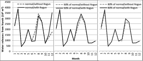
The pattern of releases from the existing Nurek Reservoir (downstream of Rogun and the largest hydropower dam in the basin at this time; see ) provides an interesting perspective on the efficient water allocation solution in this basin. The model results indicate that higher demand for irrigation water during the summer growing season is partly met by releasing greater amounts of water from Nurek in July through September (). Releases are also higher in February, when energy demand is greater and prices are higher. The addition of Rogun under normal flow conditions changes the pattern of these releases somewhat; the releases decrease slightly at the beginning of the summer season in July and August, and increase at the beginning of the winter season (December) to enhance the benefits from hydropower production. When water availability declines, however, the opposite pattern occurs: downstream releases increase slightly in summer months with the addition of Rogun, and releases in early winter decline slightly relative to the case without the dam.
Figure 2. Optimal monthly water releases from Nurek Reservoir under different levels of water availability (normal and 80% and 90% of normal) in the cooperation case.
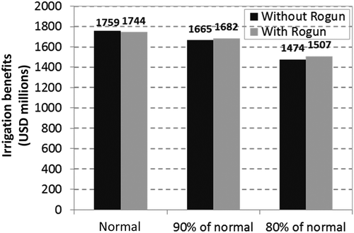
If all riparian countries cooperate, water releases from Nurek and Rogun and downstream irrigation water uses could be jointly managed to avoid harming downstream irrigation (). Under normal water supply, overall irrigation benefits in the Amu Darya basin under this cooperative case reach USD 1.76 billion without the Rogun Dam and decline by just USD 0.02 billion (1.1%), to USD 1.74 billion, when the dam is constructed. Under reduced water supply (by 20%), overall irrigation benefits decline; the addition of Rogun under these conditions would lead to a very small increase in irrigation benefits of USD 0.03 billion (2.2%). Thus, optimal management of the dam leads to only minor impacts on downstream irrigation across different levels of water availability. Since most of the river flow in the system can already be controlled using current dams (Dukhovny & de Schutter, Citation2011), the benefits of the newly constructed dams for irrigation water availability are inconsequential. Under decreased water supply scenarios, irrigation benefits decline similarly regardless of whether Rogun is added to the system, due to the limited availability of water during the summer months.
Figure 3. Dam construction impact on optimal total irrigation benefits in the Amu Darya Basin under different levels of water availability in the cooperation case.
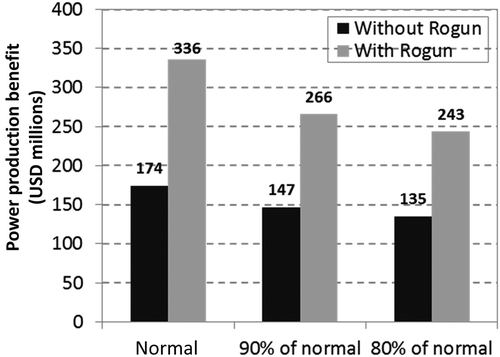
While irrigation impacts are minor if all countries cooperate, the Rogun Dam may provide substantial gains in terms of energy production (). In an average hydrological year, power production benefits would nearly double, from USD 174 million to USD 336 million. With a reduction in inflows by 20%, the magnitude of additional benefits would decrease to USD 108 million, which would still represent an 80% increase over the baseline configuration without Rogun. With modest transfers of these gains to downstream irrigators, irrigation losses (e.g. in Surkhandarya) could be compensated, making all parties better off.
Figure 4. Dam construction impact on optimal hydropower production benefits in the Amu Darya Basin under different levels of water availability in the cooperation case.
Comparison of cooperation and non-cooperation scenarios with and without the Rogun Dam
Although full cooperation to achieve basin-wide gains can provide substantial upstream hydropower gains (+93%) with very minor impacts on irrigation benefits (−1%), past experience in the basin suggests that unilateral maximization of either energy production or irrigation benefits is a possible upstream and downstream water management strategy. If upstream storage dams are regulated to maximize irrigation benefits (as occurred in the water regime in Soviet times), the addition of Rogun would increase total irrigation benefits by only 2% (DWSMX/+, ). Due to Nurek’s greater influence on flow regulation, Rogun does not play a significant role in helping enhance summer flows for use in downstream irrigation. However, hydropower production benefits would increase by 63% relative to the baseline (COOP/−). In addition, holding infrastructure constant (comparing DWSMX/− with COOP/− and DWSMX/+ with COOP/+), it can be noted from that irrigation benefits under this DWSMX regime are only about 1–2% (USD 15–42 million) higher than in the cooperative situation, whereas hydropower benefits decline by 13–16% (USD 22–53 million).
Table 3. Irrigation versus hydropower production trade-offs in an average water year under cooperation and non-cooperation scenarios.
Given recent changes in hydropolitics, a perhaps more likely scenario in the basin is that upstream hydropower production would be unilaterally optimized. The modelling results indicate that this hydropower-focused regime generates greater power benefits (+116%, or USD 202 million) relative to COOP/−. But this increase comes at a heavy cost in downstream irrigation benefits, which decline by 31% (or USD 553 million). Again holding infrastructure constant (comparing UPSMX/− with COOP/− and UPSMX/+ with COOP/+), we observe that irrigation benefits under the UPSMX regime are 11–31% (USD 201–538 million) lower than in the cooperative situation, whereas hydropower benefits increase by 12–17% (USD 30–40 million). Furthermore, this trade-off worsens when Rogun is included: irrigation benefits decline by USD 538 million while hydropower profits increase by only USD 40 million.
Discussion
The Rogun Dam has long been controversial, in part because of concerns over unequal impacts on upstream and downstream riparians of the Amu Darya Basin (Eshchanov et al., Citation2011; Wegerich, Citation2008). The project may generate substantial energy gains in Tajikistan, the upstream riparian. Meanwhile, downstream water users, in Uzbekistan and Turkmenistan, expect that it would significantly reduce summer water availability and adversely affect irrigated agriculture. The river basin modelling conducted in this article suggests that cooperative optimal basin-wide management would significantly increase hydropower production (by 93%) and result in relatively minor adverse impacts downstream in the basin (−1%). However, the effects of the dam on downstream benefits depend on the pattern of upstream reservoir water releases, and large losses (−31%) in the agricultural sector would occur if upstream hydropower production benefits were unilaterally maximized. In addition, unilateral operations would only marginally improve energy production benefits and that overall system benefits would be reduced by 18%.
Distributional concerns are only one part of the dispute over Rogun. A variety of other issues – related to transient effects on water security, alternative energy options, earthquake and flood risks, and political power asymmetries – have received attention in the literature. Based on their prior experience with the Toktogul Dam, specialists from downstream countries expect that operation of the Rogun Dam would be unilateral and purely for the purpose of hydropower production, and might also be used to serve various political objectives of the upstream riparians (Bank Information Center, Citation2013). A somewhat different dispute narrative posits that Rogun was part of a larger effort by Soviet specialists to increase regional discord and prevent regional cooperation, with the aim of enhancing Moscow’s influence in Central Asia (O’Hara, Citation2000). Lange (Citation2001) offers a contrasting view, arguing that upstream dams were planned and constructed at locations where they were more technically and economically relevant. As shown in , the basin has seen considerable development since the 1950s. During the Soviet era, upstream dams were largely built to enhance summer water availability for downstream irrigation and to prevent flooding (, compare rows 1 and 2). The change of dam operations in the greater Aral Sea basin since the fall of the Soviet Union is reflected in a shift in release patterns as shown in , row 3 (Dukhovny & de Schutter, Citation2011; Müller, Citation2006; O’Hara, Citation2000).
Table 4. Qualitative assessment of changes in irrigation and energy benefits under different reservoir water release regimes.
Somewhat related to such strategic and political considerations, downstream interests are worried about negative impacts on water security during the period immediately following construction of the dam. Depending on the filling rules implemented for the new reservoir behind Rogun, water flows to downstream users could decline significantly. Contributing to this concern is the prior regional experience in the late 1970s through the mid-1980s, when frequent water shortages coincided with the addition of the Toktogul Reservoir (in the Syr Darya Basin) and the filling of the Nurek Reservoir (Dukhovny & de Schutter, Citation2011). Future studies should assess the nature and magnitude of such transient filling impacts, using dynamic hydro-economic optimization or simulation models.
The Rogun Dam would add significant power generation capacity, and may thus significantly enhance energy security among the power-constrained economies of Central Asia (Asian Disaster Reduction Center [ADRC], Citation2006). This energy security calculation, however, largely depends on the relative generation and transmission costs of alternative supplies to end users, and on the distribution of the benefits of power generation. For example, Eshchanov et al. (Citation2011) argue that upstream provinces have high capacity for adopting alternative energy technologies, and that these would carry lower safety and financial risks than a massive new multi-billion-dollar dam. Furthermore, if the increased energy output is primarily used for export to foreign countries like India, Iran, Afghanistan and Pakistan, as previously reported (ADRC, Citation2006; Rizk & Utemuratov, Citation2012; Eshchanov et al., Citation2011), high transmission costs and additional investment needs may reduce net benefits. On the other hand, increased interconnection and mutually beneficial power trade deals within Central Asia, if economically attractive and agreeable by all riparians, may enhance the distributional outcomes of the Rogun project. However, using the additional hydropower supply to enhance or expand industrial sectors such as aluminium production in Tajikistan could create enormous externalities in the form of negative effects on environment, agricultural production, and population health in the region.
There are also important concerns about earthquakes occurring near the Rogun Dam’s location, which would increase the risks of dam failure and catastrophic downstream flooding (Bank Information Center, Citation2013). The possibility of dam failure cannot be easily included in an annual optimization model of the type used in this article, so we offer a qualitative assessment based on information available in the literature. Global maps of earthquake intensity risk indicate that the planned location of the Rogun Dam is an area with extremely high seismicity (International Strategy for Disaster Reduction [ISDR], Citation2008), and this risk was confirmed by geological investigations during the design phase (Gill et al., Citation2014; Schmidt et al., Citation2006). Earthquakes reaching 6–7 on the Richter scale occur frequently in the neighbouring region; such events have provoked landslides, ruptures of the land surface and consequent destruction of several villages, with loss of life (ADRC, Citation2006; Schmidt et al., Citation2006; Teshebaeva, Sudhaus, Echtler, Schurr, & Roessner, Citation2014). If such an event were to compromise the integrity of the dam, it could lead to major flooding and destruction in downstream communities. Prior to construction of the new dam, a detailed assessment of such risks is therefore essential and should include recommendations and joint agreement by all affected parties on the measures required for mitigating risks and planning for emergency evacuation of populations from at-risk areas. In addition, the costs of these risk mitigation measures and of the risks of destruction should be incorporated into any economic cost–benefit analysis of the dam prior to deciding whether to move forward with construction.
The seasonal water trade-offs between irrigation and hydropower production revealed in this analysis also relate to current challenges and conflicts over downstream water allocation in the study region. In this respect, it should be noted that preservation of ecosystems in the basin depends on improving the efficiency of water use in irrigation systems. At present large amounts of water are lost in depressions at the ends of irrigated areas; such water could possibly be transferred for recharge of previously vibrant environmental assets and ecosystems, particularly the Aral Sea (Micklin, Citation2007). Similarly, irrigation efficiency improvements at the farm and canal levels could reduce return flows and water losses (Bekchanov et al., Citation2010; Cai et al., Citation2003; Horst, Shamutalov, Pereira, & Gonçalves, Citation2005) and thus free up freshwater resources for restoring downstream ecosystems (Bekchanov, Ringler, & Bhaduri, Citationin press). However, irrigation improvements depend to a large extent on effective water institutions. For instance, if downstream producers invest in efficiency improvements but fail to obtain adequate water in time for their crops because of poor management of water releases, they will bear high socio-economic and financial risks. Thus, basin-wide coordination of the water releases and improved water management institutions are essential for creating incentives for increased water use efficiency (Bekchanov, Bhaduri, & Ringler, Citation2015; Djanibekov & Valentinov, Citation2015; Weinthal, Citation2001).
Overall, on the one hand, the model results presented in this article support the idea that if the above issues can be resolved and strong cooperation among the riparian countries can be established the modest negative distributional impacts of the Rogun Dam on irrigators could be effectively managed. Such management would probably entail slight modifications of the release patterns from Nurek, the hydropower facility immediately downstream of Rogun. This option would involve optimizing Rogun for hydropower production in the winter season, and operating Nurek to then ensure sufficient releases of summer water to meet downstream water demands (, row 4). On the other hand, the most likely (uncooperative) water release mode, which would include both Rogun and Nurek being operated to maximize hydropower production in winter, would improve energy production benefits only by a small amount (USD 40 million/y) relative to the cooperative regime with Rogun. Yet this regime, as shown by the modelling results (), would have very substantial negative effects on downstream irrigation interests, harming them by USD 538 million/y (, row 6).
Conclusions
As discussed above, changes in water and energy availability following the dam development in the Amu Darya Basin depend on water release modes of upstream reservoirs. When riparian countries cooperate, there is a possibility of a win-win regime of water releases from a system of upstream reservoirs that include the Rogun Dam. Model results indicate that under this cooperation scenario optimal operation of reservoirs in the Amu Darya Basin only slightly reduces downstream water availability in a normal hydrological year, and negligibly increases it in dry years. Under a water regime that prioritizes irrigation, such benefits increase only slightly following construction of Rogun. In fact, the capacity of current reservoirs in this basin is already sufficient to regulate and balance seasonal and annual variability, so the construction of additional dams does not appear beneficial for downstream irrigators. In contrast, upstream hydropower production and benefits may increase substantially with the construction of Rogun. Unfortunately, there exists a high potential for significant harm to downstream users (by −11% and −31% with and without Rogun, respectively) and to overall basin-wide benefits (by −9% and −18% with and without Rogun, respectively) if hydropower production benefits are unilaterally maximized. Seen from this perspective, the concern over Rogun among downstream interests in the basin is understandable, given that (a) it is currently unclear whether they stand to benefit from the project; (b) the dam may precipitate a shift towards a more hydropower-centred regime in the basin; and (c) the dam carries potential political, safety, and transient risks. Thus, engagement of the affected riparians in cooperative negotiations to build trust and reach mutual agreement over the operation and risk management of upstream reservoirs would seem advisable.
Despite the advantages of using hydro-economic optimization to consider the effects of this new project on the dynamics of water allocations throughout the Amu Darya Basin, the model has important shortcomings that should be addressed in future studies. Dynamic stochastic optimization and simulation approaches would provide a more complete and thorough understanding of the transient effects of dam construction, as well as uncertainties related to the economic and hydrological parameters that affect outcomes (e.g. climate change or development uncertainties). Such approaches could also partially account for the economic risks of dam failure, although this issue also mandates analysis from social and environmental perspectives. Though the data-set used in this study is recent and more consistent than that of many previous studies, data limitations – particularly with respect to variation across space and time – may somewhat bias the results. Finally, although the analysis explicitly tracks water allocations to different downstream users, the model does not address the general equilibrium effects of power production and changes in agriculture-sector output. A computable general equilibrium analysis might additionally reveal the impacts of infrastructural changes on employment and income distribution patterns and allow for an improved analysis of water use, energy production and use, and food production interlinkages.
Acknowledgements
The research is based on the results of PhD research at the Centre for Development Research (ZEF) of Bonn University. The authors are very grateful to Professor Dr Joachim von Braun (ZEF, Bonn University) and Dr Arnim Kuhn (ILR, Bonn University) for their helpful recommendations in preparing earlier versions of this article. The authors are also very thankful to an anonymous reviewer for thorough review and very constructive comments.
Additional information
Funding
Notes
1. Only the main components of the hydro-economic model are described in this section. For additional model details, see the more detailed description provided in Bekchanov (Citation2014).
2. Endogenous variables are written using uppercase letters while exogenous factors (model parameters) and identifiers (sets) are written with lowercase letters in this section.
3. It is important to note that this formulation of the economic benefits from water allocation to irrigation does not represent the diminishing returns from increased water use that is most relevant for decision-making changes in water allocation to farmers (Young & Loomis, Citation2014). A more fully consistent approach would better account for nonlinearities in the yield curve as a function of water input, as well as substitution of different inputs of labour, land and capital.
4. For a detailed description of the environmental benefit function and its estimated parameters, see Bekchanov (Citation2014, pp. 135–141).
5. For access to additional database details or the data used in this article, please contact the corresponding author.
6. For instance, farmers in Kazakhstan obtain greater benefits per unit of water than farmers in Uzbekistan, despite lower yields, largely because of liberalized prices.
7. To put the optimal results into context, we also compare the results of Scenario 1 (without Rogun) with historical data on water allocation and agricultural production.
8. Irrigators prefer to not use return flows due to their high salinity, and reused water is not fully substitutable with freshwater. Constraints on use of return flows seek to prevent unrealistic levels of reuse water substitution. In future studies, more advanced models that consider soil and water salinity and leaching relationships may better incorporate farmer preferences for water source types and better enable consideration of the water quality issues associated with reuse of drainage water.
References
- Anderson, K. (2009). Distortions to agricultural incentives: A global perspective, 1955–2007. Washington, DC: Word Bank.
- Asian Disaster Reduction Center. (2006). Tajikistan: Country report. Retrieved November 26, 2014, from http://www.adrc.asia/countryreport/TJK/2005/english2.pdf
- Bank Information Center. (2013). Tajikistan’s Rogun hydro: Social and environmental aspects. Retrieved November 28, 2014, from http://www.bicusa.org/wp-content/uploads/2013/02/Rogun+Hydro+Brief.pdf
- Bekchanov, M. (2014). Efficient water allocation and water conservation modeling (PhD thesis). Bonn University, Bonn. Retrieved from http://hss.ulb.uni-bonn.de/2014/3609/3609.pdf
- Bekchanov, M., & Bhaduri, A. (2013). National tendencies and regional differences in small business development in Uzbekistan. Paper presented at IAMO Forum, 19–21 June, 2013, Halle, Germany.
- Bekchanov, M., Bhaduri, A., & Ringler, C. (2015). Potential gains from water rights trading in the Aral Sea Basin. Agricultural Water Management, 152, 41–56. doi:10.1016/j.agwat.2014.12.011
- Bekchanov, M., Lamers, J. P. A., & Martius, C. (2010). Pros and cons of adopting water-wise approaches in the lower reaches of the Amu Darya: A socio-economic view. Water, 2, 200–216. doi:10.3390/w2020200
- Bekchanov, M., Ringler, C., & Bhaduri, A. (in press). A water rights trading approach to increasing inflows to the Aral Sea. Land Degradation & Development. doi:10.1002/ldr.2394
- Booker, J. F., & Young, R. A. (1994). Modeling intrastate and interstate markets for Colorado river water resources. Journal of Environmental Economics and Management, 26(1), 66–87. doi:10.1006/jeem.1994.1005
- Brooke, A., Kendrick, D., Meeruas, A., & Raman, R. (2006). GAMS-user’s guide. Washington, DC: GAMS Development Corporation.
- Cai, X. (1999). Modeling framework for sustainable water resources management (Unpublished Ph.D. dissertation). University of Texas at Austin Austin, USA.
- Cai, X., McKinney, D. C., & Rosegrant, M. W. (2003). Sustainability analysis for irrigation water management in the Aral Sea region. Agricultural Systems, 76, 1043–1066. doi:10.1016/S0308-521X(02)00028-8
- Cai, X., Ringler, C., & Rosegrant, M. W. (2006). Modeling water resources management at the basin level: Methodology and application to the Maipo river basin ( IFPRI Research Report 146). Washington, DC: IFPRI.
- Central Asian Research Institute of Irrigation. (2004). Problems of integrated management, rational use, and protection of water resources in the Aral Sea basin. Project report. Tashkent, Uzbekistan: SANIIRI (in Russian).
- Chatterjee, B., Howitt, R. E., & Sexton, R. J. (1998). The optimal joint provision of water for irrigation and hydropower. Journal of Environmental Economics and Management, 36(3), 295–313. doi:10.1006/jeem.1998.1047
- Chub, V. E. (2007). Climate change and its impact on hydrometeorological processes, agro-climatic and water resources of the Republic of Uzbekistan. Tashkent, Uzbekistan: Center for Hydro-meteorological Service under the Cabinet of Ministers of the Republic of Uzbekistan (Uzhydromet)/Scientific and Research Hydro-meteorological Institute (NIGMI).
- Djanibekov, N., & Valentinov, V. (2015). Evolutionary governance, sustainability, and systems theory: The case of central Asia. In R. Beunen, K. Van Assche, & M. Duineveld (Eds.), Evolutionary governance theory: Theory and applications (pp. 119–134). Cham/Heidelberg/New York/Dordrecht/London: Springer.
- Doorenbos, J., & Kassam, A. H. (1979). Yield response to water ( FAO Irrigation and Drainage Paper No. 33). Rome: FAO.
- Dukhovny, V. A., & de Schutter, J. L. G. (2011). Water in central Asia: Past, present, future. London: Taylor and Francis.
- Executive Committee of International Fund for Saving the Aral Sea. (2013). The Aral sea basin economic allocation model BEAM. Report. Retrieved August 20, 2013, from www.ec-ifas.org
- Eshchanov, B. R., Stultjes, M. G. P., Salaev, S. K., & Eshchanov, R. A. (2011). Rogun Dam—Path to energy independence or security threat? Sustainability, 3, 1573–1592. doi:10.3390/su3091573
- Eurasian Development Bank. (2008). Water and energy resources in central Asia: Utilization and development issues. Industry report. Almaty, Kazakhstan.
- Gill, R., Spasic-Gril, L., Marinos, P., Todini, E., Gummer, J., & Morris, G. (2014). Engineering and dam safety panel of experts for Rogun hydropower project: Final report. Washington, DC: World Bank.
- Groves, D. G., & Lempert, R. J. (2007). A new analytic method for finding policy-relevant scenarios. Global Environmental Change, 17(1), 73–85. doi:10.1016/j.gloenvcha.2006.11.006
- Harou, J. J., Pulido-Velazquez, M., Rosenberg, D. E., Medellín-Azuara, J., Lund, J. R., & Howitt, R. E. (2009). Hydro-economic models: Concepts, design, applications, and future prospects. Journal of Hydrology, 375, 627–643. doi:10.1016/j.jhydrol.2009.06.037
- Hashimova, U. (2014). Rogun Dam studies set the scene for further disputes among central Asian countries. Eurasia Daily Monitor, 11, 150.
- Horst, M. G., Shamutalov, S. S., Pereira, L. S., & Gonçalves, J. M. (2005). Field assessment of the water saving potential with furrow irrigation in Fergana, Aral Sea basin. Agricultural Water Management, 77(1–3), 210–231. doi:10.1016/j.agwat.2004.09.041
- International Food and Policy Research Institute. (2013). Data on crop evapotranspiration and effective rainfall across the main climatic zones of central Asia based on IMPACT model database (Excel files delivered by Dr. Claudia Ringler and Dr. Tingju Zhu on July 24, 2013).
- International Strategy for Disaster Reduction. (2008). The map of earthquake intensity risk zones. Retrieved November 27, 2014, from http://www.seismo.ethz.ch/sattic/gshap/
- Jeuland, M., Baker, J., Bartlett, R., & Lacombe, G. (2014). The costs of uncoordinated infrastructure management in multi-reservoir river basins. Environmental Research Letters, 9, 105006. doi:10.1088/1748-9326/9/10/105006
- Jeuland, M., Harshadeep, N., Escurra, J., Blackmore, D., & Sadoff, C. (2013). Implications of climate change for water resources development in the Ganges basin. Water Policy, 15, 26–50. doi:10.2166/wp.2013.107
- Jeuland, M., & Whittington, D. (2014). Water resources planning under climate change: Assessing the robustness of real options for the blue Nile. Water Resources Research, 50(3), 2086–2107. doi:10.1002/2013WR013705
- Lange, K. (2001). Energy and environmental security in central Asia: The Syr Darya. Centre for Strategic and International Studies (CSIS). Retrived from http://www.csis.org/ruseura/cs010220lange.htm
- Lucky, M. (2012). Global hydropower installed capacity and use increase. Washington, DC: Vital Signs/World Watch Institute. Retrieved from http://vitalsigns.worldwatch.org/vs-trend/global-hydropower-installed-capacity-and-use-increase
- Malik, R. P. S. (2007). Do dams help reduce poverty? Journal of the Indian Society of Agricultural Statistics, 61(2), 199–207.
- Ministry of Agriculture and Water Resources of Uzbekistan. (2007). Conveyance costs of delivering one cubic m of water to the irrigation regions in 2006. Unpublished report. Tashkent, Uzbekistan.
- McKinney, D. C. (2004). Cooperative management of transboundary water resources in central Asia. In D. Burghart & T. Sabonis-Helf (Eds.), In the tracks of tamerlane: Central Asia’s path to the 21st century (pp. 187–220). Washington, DC: National Defense University.
- Micklin, P. (2007). The Aral sea disaster. Annual Review of Earth and Planetary Sciences, 35, 47–72. Retrieved July 28, 2011, from http://www.annualreviews.org/doi/pdf/10.1146/annurev.earth.35.031306.140120
- Molden, D. (Ed.). (2007). Water for food, water for life: A comprehensive assessment of water management in agriculture. London: Earthscan.
- Müller, M. (2006). A general equilibrium analysis of water and land use in Uzbekistan (PhD dissertation). Bonn University, Bonn, Germany.
- O’Hara, S. (2000). Central Asia’s water resources: Contemporary and future management issues. International Journal of Water Resources Development, 16(3), 423–441. doi:10.1080/713672501
- Ringler, C., Bhaduri, A., & Lawford, R. (2013). The nexus across water, energy, land and food (WELF): Potential for improved resource use efficiency? Current Opinion in Environmental Sustainability, Rosegrant, M.W., C 5(6), 617–624. doi:10.1016/j.cosust.2013.11.002
- Ringler, C., von Braun, J., & Rosegrant, M. W. (2004). Water policy analysis for the Mekong river basin. Water International, 29(1), 30–42. doi:10.1080/02508060408691746
- Rizk, J., & Utemuratov, B. (2012). Balancing the use of water resources in the Amu Darya basin. Policy brief. Retrieved August 30, 2013, from www.amudaryabasin.net
- Robinson, S., & Gueneau, A. (2014). Economic evaluation of the Diamer-Basha Dam: Analysis with an integrated economic/water simulation model of Pakistan. PSSP Working Paper. Retrieved from April 13, 2015 http://www.ifpri.org/sites/default/files/publications/psspwp14.pdf
- Rosegrant, M. W., Ringler, C., McKinney, D. C., Cai, X., Keller, A., & Donoso, G. (2000). Integrated economic-hydrologic water modeling at the basin scale: The Maipo river basin. Agricultural Economics (IAEA), 24(1), 33–46.
- Rosegrant, M. W., Ringler, C., & Zhu, T. (2009). Water for agriculture: Maintaining food security under growing scarcity. Annual Review of Environment and Resources, 34, 205–222. doi:10.1146/annurev.environ.030308.090351
- Schmidt, R., Zambaga-Schulz, S., & Seibitz, M. (2006). Bankable feasibility study for Rogun HEP stage I construction completion in Tajikistan. In L. Berga, J. M. Buil, E. Bofill, J. C. De Cea, J. A. Garcia Perez, G. Maňueco … J. Yagűe (Eds.), Dams and reservoirs, societies and environment in the 21st century. London: Taylor & Francis.
- SIC-ICWC. (2008). Crop production costs and revenues across the regions of Uzbekistan in 2006 (based on different SIC-ICWC reports). Tashkent, Uzbekistan.
- SIC-ICWC. (2011). CAREWIB (Central Asian Regional Water Information Base). Retrieved January 27, 2012, from www.cawater-info.net
- Scientific-Information Center of Interstate Commission of Water Coordination in the Aral Sea Basin. (2003). The database of the Aral sea basin optimization model (ASBOM). Excel file. Tashkent, Uzbekistan.
- Spoor, M., & Krutov, A. (2003). The ‘power of water’ in a divided Central Asia. PGDT, 2(3–4), 593–614.
- Strzepek, K. M., Yohe, G. W., Tol, R. S. J., & Rosegrant, M. W. (2008). The value of the high Aswan Dam to the Egyptian economy. Ecological Economics, 66(1), 117–126. doi:10.1016/j.ecolecon.2007.08.019
- Teshebaeva, K., Sudhaus, H., Echtler, H., Schurr, B., & Roessner, S. (2014). Strain partitioning at the eastern Pamir-Alai revealed through SAR data analysis of the 2008 Nura earthquake. Geophysical Journal International, 198, 760–774. doi:10.1093/gji/ggu158
- Tolstov, S. P. (2005). Following the tracks of ancient Khorezmian civilization. UNESCO. First published in Russian language in 1948 by the Publishing House of the Academy of Sciences of the USSR, Moscow-Leningrad.
- UNEP. (2005). Aral sea, GIWA regional assessment 24. Severskiy, I., Chervanyov, I., Ponomarenko, Y., Novikova, N.M., Miagkov, S.V., Rautalahti, E. and D. Daler Kalmar, Sweden: University of Kalmar.
- Wegerich, K. (2008). Hydro-hegemony in the Amu Darya Basin. Water Policy, 10(5), 71–88.
- Wegerich, K., Olsson, O., & Froebrich, J. (2007). Reliving the past in a changed environment: Hydropower ambitions, opportunities and constraints in Tajikistan. Energy Policy, 35(7), 3815–3825. doi:10.1016/j.enpol.2007.01.024
- Weinthal, E. (2001). Sins of omission: Constructing negotiating sets in the Aral sea basin. Journal of Environmental Development, 10(1), 50–79.
- Whittington, D., Wu, X., & Sadoff, C. (2005). Water resources management in the Nile basin: The economic value of cooperation. Water Policy, 7, 227–252.
- World Bank. (2014). Assessment studies for proposed Rogun hydropower project in Tajikistan. Washington, DC: World Bank. Retrieved from http://www.worldbank.org/en/region/eca/brief/rogun-assessment-studies
- Wu, X., Jeuland, M., Whittington, D., & Sadoff, C. (2013). Interdependence in water resource development in the Ganges: An economic analysis. Water Policy, 15, 89–108. doi:10.2166/wp.2013.003
- Young, R. A., & Loomis, J. B. (2014). Determining the economic value of water: Concepts and methods. New York, NY: Resources for Future Press.