
ABSTRACT
Shared groundwater resources between Mexico and the United States are facing unprecedented stressors. We reflect on how to improve water security for groundwater systems in the border region. Our reflection begins with the state of groundwater knowledge, and the challenges groundwater resources face from a physical, societal and institutional perspective. We conclude that the extent of ongoing cooperation frameworks, joint and remaining research efforts, from which alternative strategies can emerge, still need to be developed. The way forward offers a variety of cooperation models as the future offers rather complex, shared and multidisciplinary water challenges to the Mexico–US borderlands.
Introduction
Groundwater is estimated to account for 97% of available global freshwater resources (World Resources Institute, Citation1990). Worldwide, the increase in population coupled with water scarcity and the degradation of water quality have highlighted the need for transboundary water management agreements (Draper & Kundell, Citation2007). The efforts supporting the development of joint assessments of equitable allocation of surface water and groundwater, with particular attention to sustainability, vulnerability to contamination, and management of wildlife and ecosystem preservation, are slowly but diligently elevating the priorities of the global water agenda on transboundary water resources (UNECE & UNESCO, Citation2021).
While some international laws governing transboundary surface water do exist, shared groundwater resources have long been neglected by both the international legal regime and most transboundary water management agreements. The ‘invisibility’ of the resource, combined with its natural physical complexities and the fact that sustainable groundwater use has not drawn much attention until recent decades (Gleeson et al., Citation2019), significantly contributed to the lack of policy development at the cross-border level. Additionally, the lack of transboundary coordination at a worldwide level has been highlighted in the literature as the main cause of poor multinational groundwater management approaches (Eckstein, Citation2017). Recently, due to the impacts of climate change, population growth and widespread pollution of surface water, policymakers and water managers are moving towards a paradigm of water being ‘more protected underground’ (UNECE, Citation2014). As a result, conservation measures, as well as the conjunctive use of surface and groundwater resources, have become more important and strategic at the transboundary level.
In the case of the waters shared between Mexico and the United States, two complementary binational surface water agreements are in place: the 1906 Convention between the United States and Mexico, Equitable Distribution of the Waters of the Rio Grande, and the 1944 United States and Mexico Treaty of the Utilization of Waters of the Colorado and Tijuana Rivers and of the Rio Grande (together referred as ‘the Water Treaties’). The Water Treaties provide the legal framework governing the three major binational rivers and their tributaries shared between Mexico and the United States, but do not cover other transboundary rivers (such as the Santa Cruz and San Pedro rivers, just to mention a couple) or any shared groundwater resources. The Water Treaties also do not recognize the physical linkages between surface water and groundwater in transboundary watersheds and aquifers. In addition, climatic variability and climate change, as well as expectations of population growth, were not considerations when the Water Treaties were developed. Furthermore, the total volumes of water in the river basins managed under these treaties were quantified according to measured water values recorded in the early 1900s when the region was less arid.
With demand increasing for new sources of water, greater pressure is now being placed on the region’s groundwater resources, thereby intensifying the need for cooperation over transboundary aquifers (TBAs) (Rivera et al., Citation2015). However, in the border region of Mexico and the United States, as in many other borders around the world, cooperation related to groundwater resources faces challenges that need to be recognized and addressed before any new policies and approaches are suggested at a binational level, or even proposed for incorporation into the existing Water Treaties. Several elements essential to sustainable and long-term water management are required. These include: bilateral effective communication that incentivizes the exchange of data and information on current groundwater conditions (e.g., hydraulic head records, abstraction rates, land uses, surface–groundwater interactions and water quality); second, joint criteria for aquifer and watershed delineation and monitoring; third, a comprehensive plan for surface–groundwater conjunctive use; fourth, conservation and protection of shared endangered habitats; and fifth, governing legal principles for management and sustainability of these shared resources.
This paper describes the challenges in the border region and makes recommendations as to how to build and improve water security for surface and groundwater systems in the border region between Mexico and the United States. We begin by describing the state of groundwater knowledge in the region and its implications for water security. Main topics include: (1) the current state of knowledge about groundwater; (2) groundwater use and competition; (3) water security challenges related to groundwater and surface water; (4) hydrological and water resources models, from numerical and governance-management approaches to support holistic decision-making; and (5) a proposed research agenda and path forward. We conclude that increased funding availability, research development and data generation, and prioritization within a coordinated binational agenda are needed to advance in terms of water security for groundwater systems in the border region.
While there are many transboundary connections that must be bridged, this paper unearths several relevant lessons to enhance the stewardship of transboundary water resources between Mexico and the United States.
Transboundary groundwater resources in the Mexico–US border region
Geographical setting
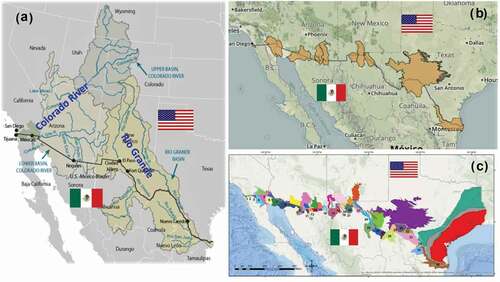
There are numerous TBAs along the 3145 km-long Mexico–US border supporting ecosystems, socioeconomic development and the well-being of more than 10 million people in 30 cities and communities (). However, there is no consensus on the exact number of TBAs in the border region nor on their geographical delineations. Some authors list 11 TBAs (UNESCO, Citation2010) (), while others suggest that there might be up to 36 TBAs (Sanchez et al., Citation2016) (). Differences in definitions, criteria and methodologies account for much of these numerical disparities.
Figure 1. Map showing (a) the 3145 km international border with the main rivers between Mexico and the United States (CRS, Citation2018); (b) transboundary aquifers along the Mexico–US border according to UNESCO (Citation2010); and (c) transboundary aquifers along the Mexico–US border according to Sanchez et al. (Citation2016)
Assessment of these TBAs reveals marked differences between the two countries in terms of subsurface characterization, available information, monitoring schemes, management models and outreach policies.
While the two Water Treaties address surface waters in the border region, Minute 242 (an amendment to the 1944 Treaty that focuses on an aquifer in the Sonora–Arizona border) is the only legally binding agreement between Mexico and the United States to address binational groundwater resources (Sanchez & Eckstein, Citation2020a). There are no agreements between the two countries that address conjunctive use of surface and groundwater. Further, different water policies, water ownership regimes and governance approaches at the national and subnational levels within each country pose challenges for potentially managing transboundary waters (Megdal & Scott, Citation2011).
Gaps in knowledge exacerbate the challenge of managing TBAs along the borderlands. The three fundamental unknowns include knowledge of groundwater extraction and use, natural and artificial groundwater recharge, and land use, all of which are key elements of the groundwater budget (Kim & Jackson, Citation2012; Rivera et al., Citation2015). While the general perception is that groundwater is being extracted at rates greater than natural and artificial recharge, there are no datasets to assess or confirm this claim outside of inferences from groundwater-level declines at a border-wide scale. Existing data are limited to the political boundaries of each country or subnational state.
On the US side, states such as New Mexico have required monthly pumping reports since 2009 for every well (Hanson et al., Citation2020). However, land use is not regularly mapped to track agricultural, municipal or ecosystem water uses. Aquifer levels are monitored in established networks, and in California, groundwater use is estimated within specific groundwater basins under the California Statewide Groundwater Elevation Monitoring Program (CASGEM) (Citation2021). These data are generated either by the federal government (US Geological Survey – USGS), or by the states along the border (California, Arizona, New Mexico and Texas). However, there is no integration of withdrawal rates and other data into a single continuous database for the entire border that transcends political jurisdictions. Arizona, for example, has established an active management area in the Santa Cruz TBA that has withdrawal reporting requirements, but only for the Arizona part of the aquifer. Additionally, there is no withdrawal reporting for the San Pedro TBA on either side of the border (Megdal & Scott, Citation2011).
Within Mexico, groundwater uses by private sectors are implemented as groundwater concessions (groundwater rights permitted from the federal government), however these concessions are not systematically monitored or measured for all users and uses. Once a concession is officially granted, users do not always report their water use as required by CONAGUA, the centralized federal water agency in Mexico, and, in many cases, extract more groundwater than the amount officially allowed. Thus, estimates of groundwater extraction are inexact and can be subject to large biases and errors (Sanchez et al., Citation2010). CONAGUA applies a water balance for ‘officially delineated basins’, which includes both surface water and groundwater boundaries as ‘administrative units’ (Sanchez et al., Citation2016). However, in most cases, the water balance is incomplete and biased as statistics are based on old and limited data instead of annually updated estimates. CONAGUA has applied management measures such as the Aquifer Protection Act, which limits pumping rates and restricts pumping areas (zonas de veda) where abstraction has been reported to exceed annual recharge. However, these efforts have not been enough to constrain consistent declines in groundwater tables, and groundwater quality degradation has increasingly been reported in the border region (CONAGUA, Citation2015). Additionally, the amount of illegal groundwater pumping on the Mexico side is believed to account for a substantial portion of water pumping in the region (Loch et al., Citation2020).
In terms of research, from the centre to the south-east of the border to the Lower Rio Grande/Rio Bravo basin, important binational studies have been conducted, such as for the Santa Cruz (ongoing) and San Pedro watersheds and the Lower Rio Grande basin (Callegary et al., Citation2018, Citation2016; Hanson et al., Citation2013), all of which were funded by the Transboundary Aquifer Assessment Program (TAAP). Additional regional studies were developed for the Mimbres–Las Palmas aquifer (Hanson et al., Citation1994), the transboundary region of the Lower Rio Grande basin in the Rincon Valley, the Mesilla Bolsón, the Conejos–Médanos aquifer (Hanson et al., Citation2020; Ritchie et al., Citation2018; Sweetkind, Citation2017; Sweetkind et al., Citation2017), the Hueco Bolsón (Heywood & Yager, Citation2003), and the Allende–Piedras Negras (APN) aquifer (Rodriguez et al., Citation2020). The Tijuana River Watershed is part of an ongoing USGS projects and, in the case of the Lower Colorado River Basin, the integration of surface water and groundwater at the transboundary level with a conceptual model is currently being pursued as a first step in a bilateral scientific assessment (Cital et al., Citation2021). However, participation in these efforts from the Mexico side has been very limited (Danskin, Citation2020). Current assessments can only be considered as initial steps towards a more refined integration of binational data for potential transboundary groundwater management. Current modelling results tend to be limited to a portion of the aquifer, and other studies are often limited to general assessments of physical conditions of the aquifers. While some more in-depth binational management approaches are under development (Callegary et al., Citation2018; Sanchez & Eckstein, Citation2020a), data-sharing, joint studies and monitoring are largely absent.
While there have been a few isolated efforts to develop the state of knowledge on Mexico–US TBAs, in general there is a significant lack of binational cooperation at the technical, institutional and managerial levels. The TAAP, which was funded by the US government and facilitated by the International Boundary and Water Commission (IBWC), has promoted the development of protocols and principles for transboundary groundwater data-sharing for priority TBAs in Texas, New Mexico and Arizona (La Mesilla and Hueco Bolsón, Santa Cruz, and San Pedro) on the US side, and Sonora and Chihuahua on the Mexican side (Senate Reports, Citation2006). However, the funding and framework for coordinated monitoring networks and maintaining data-sharing and developing data protocols that are facilitated by TAAP are still limited.
While there have been some case studies in which groundwater budgets were estimated for particular TBAs using conceptual and/or numerical models, only four model studies that straddle the border have been published: for the Hueco Bolsón (Heywood & Yager, Citation2003), the Lower Rio Grande basin (Hanson et al., Citation2020), the Mimbres Basins (Hanson et al., Citation1994) and the APN aquifer (Rodriguez et al., Citation2020). Groundwater budgets for other TBAs on the border are based on inferred or basin-wide mass-balance estimates (Rivera et al., Citation2015).
Groundwater-use estimates for the 11 TBAs shown in are recognized by the two countries (), however most of these assessments were compiled during the International Shared Aquifer Resources Management (ISARM) Americas Network meetings held in 2010 (Rivera et al., Citation2015), and some are from the above-mentioned models. These estimates vary in accuracy, timescales and level of detail, and are incomplete. As shown in , information on groundwater extraction rates and potential overexploitation threats is one of the most important knowledge gaps in the region. The estimates collectively indicate that most TBAs along the border are overexploited with groundwater extraction rates slightly exceeding recharge rates by 14%. Additionally, many smaller TBAs are not catalogued, monitored, assessed or managed (Sanchez et al., Citation2016).
Table 1. Officially recognized transboundary aquifers along the Mexico–US border
Understanding groundwater use and competition
Agriculture is the most important and largest anthropogenic user of groundwater along the border; other uses include municipal, domestic, mining and industrial. For example, the Mexicali Valley in Baja California, located in the southernmost part of the Lower Colorado River Basin Transboundary Aquifer (LCRB), has been one the most important agricultural regions on the Mexican side of the border since the 1950s. The LCRB is primarily recharged from the Colorado River, although induced recharge from agriculture has also played an important role for the aquifer. Prior to 2010, Mexican agriculture in the Mexicali Valley suffered from water logging conditions as a result of leakage from the All-American Canal. However, that leakage also provided about 74 × 106 m3/year of artificial recharge to the TBA (Hanson et al., Citation2015). With the lining of the canal completed in 2010, less water leaked into the Mexicali Valley, which put farmers in Mexico under pressure to extract more groundwater more quickly, thereby overexploiting the aquifer, deteriorating water quality and inducing saltwater intrusion from the Mar de Cortés (Gulf of California). This case provides an example of the magnitude of the interlinkages of a shared surface–groundwater system and how they can be impacted at different scales by a unilateral measure on one side of the border.
As with the growth of water used in agriculture, municipal and industrial uses of groundwater have steadily increased over the last few decades due to growing metropolitan areas and expansion of Maquiladoras (manufacturers assembling products from raw materials primarily for export) in northern Mexico along the border. International companies have been attracted by a good-quality workforce and inexpensive labour and, in most cases, the Maquiladoras rely on local groundwater from TBAs. In addition, there are other less evident but important growing uses for groundwater, such as mining along the Arizona/Sonora border, beer production in Coahuila and Sonora, and hydraulic fracturing activities in Texas (Rodriguez et al., Citation2020). Similar stresses and competition for surface water in the northern states of Mexico are expected to induce collateral damage and conflicts for Mexican agriculture in the Conchos River basin in Chihuahua, and for farmers in the Mexicali Valley of Baja California where declining surface water availability will need to be supplemented with groundwater from TBAs.
In addition, recent advances in horizontal drilling and hydraulic fracturing techniques that require the injection of a large volume of water-based pressurized fluid to increase shale permeability and enhance oil recovery have allowed profitable large-scale production of unconventional oil and gas, which in some plays reaches approximately 1 million barrels of oil/day. That is the case of the Eagle Ford Shale, a transboundary hydrocarbon-rich formation crossing from south Texas into north-east Mexico. Because of the large volumes of water needed in the hydraulic fracturing process, domestic and international concerns have been raised regarding water scarcity and depletion, as well as the environmental, geological and hydrogeological impacts of hydraulic fracturing development and produced water disposal. These latter concerns include induced seismicity, changes in land use, landscape fragmentation and aquifer pollution, to name a few.
Water extracted to satisfy hydraulic fracturing production has progressively increased over the last few years. In Texas, water use in the Eagle Ford Shale between 2009 and 2011, in 2016, and between 2015 and 2017 was in the order of about 16,000, about 33,000, and about 38,000 m3/frac well, respectively (Hernández-Espriú et al., Citation2019; Ikonnikova et al., Citation2017). The accumulated volume of water used in the Eagle Ford play to fracture more than 5400 wells drilled in 2015–17 totalled about 190 Mm3 (Groundwater Protection Council et al., Citation2011). See Hernández-Espriú et al. (Citation2019, , p. 147) for a summary of relevant research on the water footprint associated with hydraulic fracturing production. A total of 80% came from fresh surface and groundwater sources, while about 20% originated from brackish aquifers (Ikonnikova et al., Citation2017). These figures reveal that unconventional oil and gas development has become a high water-demanding user in the region. On the Mexican side of the Eagle Ford play (correlative units within the Sabinas and Burgos basins), while unconventional resources remain unexploited, their potential development will rely almost entirely on local aquifers. Although groundwater use for fracturing might not be a significant user at the regional level, it does represent an important consumptive use at local levels with considerable impacts on local groundwater systems (Hernández-Espriú et al., Citation2019).
Groundwater and water security
Water supply from the basins of the Colorado, Tijuana and the Rio Grande/Bravo rivers is increasingly becoming scarce, thereby threatening the region’s water security (Cohen, Citation2005). According to the United Nations Council on Water Security in the context of transboundary waters, water security can be defined as:
the capacity of a population to safeguard sustainable access to adequate quantities of acceptable quality water for sustaining livelihoods, human well-being, and socio-economic development, for ensuring protection against water-borne pollution and water-related disasters, and for preserving ecosystems in a climate of peace and political stability. (UN Water, Citation2013)
The most important water security challenges identified in the transboundary basins in the Mexico–US borderlands are the following:
Water over-allocation: the Colorado River Basin is considered one of the most over-allocated river systems in the world (Castle et al., Citation2014; Christensen et al., Citation2004). It has a total area of 637,137 km2, of which almost 98% is in the United States. It has an average runoff of 19,735 hm3/year and an estimated water allocation among the different consumptive uses of about 21,586 hm3/year. Reservoir storage capacity across the basin represents about five times the annual naturalized flow, hence water allocation exceeds mean annual availability at the expense of storage from surface reservoirs and groundwater aquifers. Over-allocation is due in part to allocation levels having been set in 1922 during a period of above-average streamflow relative to more recent long-term streamflow records (Scanlon et al., Citation2015). Castle et al. (Citation2014) suggest that future water allocated volumes might be jeopardized as water availability continue to decline. On the Rio Grande/Bravo, the basin has a total drainage area of 471,928 km2, of which just over half is located in the United States. It has an estimated average runoff of 10,467 hm3/year, of which almost 5762 hm3 runs off in Mexico, and an estimated annual water over-allocation of 7076 hm3 (CONAGUA, Citation2020). The implications of having international river basins with over-allocated water rights and growing water scarcity conditions puts additional pressure on the binational agenda as water rights preferences and priorities at transboundary levels become more complex and require a shared binational management vision that has yet to be developed for the region.
Global climate change: the most prominent hydroclimatic change in the Colorado River Basin over the past 40 years has been a substantial warming trend, which has altered land surface hydrology and induced a decline in water availability. The latest studies report that runoff from the Colorado River has decreased by 9.3% for each degree increase in temperature since the 1910s (Milly & Dunne, Citation2020), whereas climate models based on the RCP8.5 scenario (the worst-case climate change scenario) suggest that streamflow is expected to fall between 19% and 31% by 2065 (Lukas & Payton, Citation2020), mostly due to dwindling snowpack. In the Rio Grande/Bravo basin, the scenario is not very different. In recent decades, the snowpack has decreased by about 25% and the region is expected to experience a water supply deficit of almost 740 hm3 by 2060 (USBR, Citation2016, Citation2017). The current climate change scenarios as a main binational challenge, compared with the over-allocation challenge, represent an even more complicated issue given the inherent uncertainty of the phenomena, lack of control, and the corresponding preparedness and adaptation strategies that are required at the transboundary level to mitigate climatic impacts in the region.
Anthropogenic alteration of the water cycle: human activities exert both significant direct and indirect pressure on terrestrial water availability with negative consequences for the region, not only on the quality of life of the population, but also on natural ecosystems and biodiversity (Wu et al., Citation2020). This pressure is caused, in part, by rapid population growth, urbanization and economic development in the region, which are expanding demand and, thereby, exacerbating water scarcity. The pressure on terrestrial water availability is also the product of an increase in the frequency and intensity of climate variability and extreme hydrometeorological events, which led to the development of hydraulic infrastructure for water storage and hydropower generation that altered the natural water cycle regime and adversely affected local ecosystems (Pitt et al., Citation2017). This latter situation is especially concerning where the traditional engineering approach of ‘grey infrastructure’ development, such as dams, dikes and reservoirs, has been utilized.
Water quality degradation: urbanization, land-use changes, agricultural runoff, lack of monitoring and regulation of illegal discharges into surface water bodies, and unregulated extraction of groundwater in the region have degraded water quality of both surface and groundwater bodies at different scopes and scales. Examples of degraded water quality can be seen in the increasing salinity levels in the Hueco Bolsón (Heywood & Yager, Citation2003), the Lower Rio Grande regions (Hanson et al., Citation2020) and the Mimbres–Las Palmas region (Hanson et al., Citation1994), as well as surface water and groundwater quality degradation from sewage effluent discharge in the Santa Cruz and Tijuana River watersheds (IBWC Minute 320). Public health concerns as well as irrigated agriculture that depend on international basins as their main water source have dominated the binational agenda in terms of cooperation efforts and investment on water treatment (IBWC, Citation2021; Sanchez & Eckstein, Citation2020b).
Surface water and groundwater interactions
Addressing the interactions between surface water and groundwater is critical for achieving water security along the border. Groundwater pumping can affect base flows, while surface water diversions can influence groundwater recharge (Alley et al., Citation1999). Along the Mexico–US border, concerns related to surface–groundwater interactions arise on several fronts, including the impacts of groundwater abstractions on surface water rights, the timing and quantity of flows needed to support ecosystems, increasing water extraction levels due to climate change/variability and impacts on surface water availability, as well as population growth and other shifts in demands for water (Cuthbert et al., Citation2019; Famiglietti, Citation2014).
Understanding these interactions is often difficult, especially in regions that span various system boundaries, whether those systems are natural, political or socioeconomic. These complications stem not only from the international political boundary between Mexico and the United States, but also from other political boundaries at the state, county and city levels. For example, current and past locations of the deltas of the Rio Colorado and Rio Grande rivers, encompass terrains with a variety of fragile, yet highly productive ecosystems and microecosystems whose health depend highly on sustained, periodic freshwater and instream flows. Rapid development and resulting socioeconomic changes throughout both basins, coupled with increasing water withdrawals for municipal and irrigation uses, have significantly reduced instream and freshwater inflows in the most downstream portions of these rivers.
Both rivers are flood-pulse flow-dominant systems that are highly impacted by natural and anthropogenic factors that reduce the average annual flows, impacting groundwater recharge and discharge into sensitive ecosystems highly dependent on groundwater for their sustainability (e.g., Big Bend National Park). Flows in these rivers are currently low with only periodic, and often short-lived, higher flow periods that occur during occasional heavy rainfalls over their contributing watersheds. The predominantly arid to semi-arid climate conditions found throughout these subtropical and middle-latitude basins result in high evaporation losses and frequent drought periods, further reducing runoff and the baseflows of both river systems. Additionally, dams, reservoirs and diversions have altered the natural hydrological processes in both river systems by reducing mean and peak streamflows throughout their reaches. These reduced flows, coupled with ever-increasing urban and agricultural withdrawals and consumption, have led to both basins, especially the Colorado River basin, being listed among the most overallocated in the world (Christensen et al., Citation2004). The natural consequence has been an increasing demand on groundwater in the region and an increasing trend towards the utilization of brackish groundwater desalination to meet growing municipal water demands, such as in the case of the Lower Rio Grande Valley (Meyer et al., Citation2014). Therefore, the need for a better understanding of surface water and groundwater interactions for economic and environmental sustainability on both sides of the Mexico–US border is a necessary priority (USBR, Citation2016, Citation2017).
While there is evidence that reduced streamflows in both the Rio Grande and Colorado River have impacted deltaic ecosystems, water availability and policy issues, it is less clear what role they have had on local groundwater resources (e.g., Kennedy et al., Citation2017). Data collection has been limited by funding, and lack of collaboration efforts and institutional trust has impeded access to information related to infiltration to and connectivity between surface water and groundwater. However, it is increasingly suspected that connections between the two played vital roles historically in maintaining ecosystem health as well as surface water hydrography, quantity and quality. As demand for water grows in both basins, gathering data to confirm this historical connection, what linkages persist today, and the effects of decoupling them from one another is becoming paramount for water security, ecosystem sustainability, and exploring options for cross-border water policy moving forward.
In terms of management and policy development, the interactions between surface water and groundwater are complex and substantial data and analysis are needed to determine the relationships between groundwater uses, groundwater flow, surface water uses and surface water flows (Kalbus et al., Citation2006). When change needs to occur within an institutional management system, often (though, not always) the starting point for negotiations is demonstration of impacts, such that the evidence establishes who is responsible for what actions and what the impacts of those actions may be. Understanding the institutional system limitations, gaps and needs is a crucial element for assessing these impacts, yet, throughout the borderlands, the knowledge base needed to understand the system is incomplete.
This knowledge uncertainty hampers the development of a legal and regulatory framework for addressing surface water and groundwater interactions that is also fraught with knowledge gaps. The Water Treaties do not address groundwater or local runoff (e.g., irrigation return flows and small arroyos in sub-watersheds) within the watersheds (Mumme, Citation2000; Sanchez & Eckstein, Citation2020b), and the polycentric and multilevel structure of authority over groundwater and surface waters in both countries (Milman & Scott, Citation2010) means that there is no consolidated framework for addressing surface water and groundwater interactions. In Mexico, the federal government oversees groundwater throughout the country (Hernandez, Citation2003; Ramírez, Citation1967), albeit with some limited decentralization of authority to watershed councils and groundwater technical committees (COTAS) (Wester et al., Citation2009). In the United States, groundwater quantity and allocation are primarily managed by the states and enforced by the Supreme Court (Hesser, Citation2011), whereas the federal government has authority on issues connected to interstate commerce, including groundwater quality and endangered species (Mumme, Citation2005; Thompson et al., Citation2000). As a result, each state has its own system for addressing surface water and groundwater interactions.
While there are many barriers to addressing surface water and groundwater interactions along the borderlands, progress has been made over the past two decades. At the binational level, some of these policy actions include Minutes 242, 316, 319 and 323, which allude to the need to consider groundwater pumping and instream flows at the binational level. Additionally, within the United States, the listing and protection of species under the Endangered Species Act is leading to actions that address surface water and groundwater interactions (e.g., see the Upper Colorado Endangered Fish Recovery Program, the San Juan River Basin Recovery Implementation Program and the Lower Colorado Multispecies Conservation Program). State-of-the-art numerical modelling in the Mexico–US border region has been conducted for several TBAs. In the Lower Rio Grande River segment located at the intersection of New Mexico, Texas and Chihuahua (), a joint USGS and US Bureau of Reclamation (USBR) effort analyses conjunctive use with an integrated hydrological transboundary model (Hanson et al., Citation2020) that provides a physically based flow model embedded in a supply-and-demand framework (Boyce et al., Citation2020; Hanson et al., Citation2014).
Figure 2. Areas modelled by the Rio Grande Transboundary Integrated Hydrologic model (RGTIHM) in the Transboundary Rio Grande River area of New Mexico, Texas and Mexico, along with an active hydrologic model grid, selected climate stations and rivers for specific areas showing the total extent of the model area, including watersheds and groundwater basins
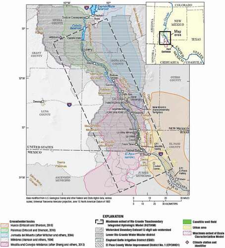
This modelling effort started with the TAAP (Hanson et al., Citation2013) and was then used by the USBR (Ferguson & Llewellyn, Citation2015; USBR, Citation2016, Citation2017) to assess climate change and confirm the efficacy of the 2008 Operating Agreement for the Rio Grande Project (USBR, Citation2008) and the 1906 Treaty (IBWC, Citation1906). The holistic framework combines science (data and modelling), policy and governance to produce a more dynamic operating management capacity for conjunctive use. The result is both short- and long-term sustainability of water uses that enhances water security and increases resilient capacity in the face of climate change/variability. This model, however, does not include Mexican groundwater data for the Conejos–Médanos aquifer, therefore its application is valid only for the US side of the aquifer.
Another effort is the numerical model developed for the APN TBA. This is one of the few TBA systems where cross-formational groundwater flow along the Mexico–US border has been scientifically studied by means of numerical modelling approaches (Rodriguez et al., Citation2020). The APN management unit is a strategic aquifer for Mexico because it supplies 85% of the total water needs in the APN aquifer region (Rodriguez et al., Citation2020). Moreover, this aquifer will likely experience additional water demand (about 56–128 Mm3/year) to satisfy future shale gas/oil development in the area (Hernández-Espriú et al., Citation2019). Despite its importance, very little formal research has been conducted regarding local, regional and transboundary aspects of the APN aquifer. This model, however, does include data from the Mexican side that have been compiled under the memorandum of understanding between Texas AgriLife Research and the Instituto Mexicano de Tecnología del Agua (IMTA), which developed a data-sharing portal in 2019 (TWRI, Citation2019).
Several basic uncertainties still exist that clearly limit binational numerical and management approaches in transboundary systems, including: (1) inconsistency in Mexican and US aquifer delineation methodologies, as the former is based on arbitrary limits that ignore geological features/structures/contacts, while the latter is based on geological boundaries; (2) poorly understood outcropping and sub-cropping correlative units along the border region’s hydrostratigraphy; and (3) different unification or separation criteria used to characterize groundwater flow and/or aquifer systems between the two countries.
Proposed research agenda and the way forward
Our review of TBA-related topics laid bare some pressing knowledge gaps that need to be addressed to improve water security in the border region. Here, we identify and provide recommendations on a path that could guide researchers and scholars on the way forward.
Improving transboundary coordination and collaboration
According to the perspectives presented in this study and the conclusions of previous sections, the path forward will need to incorporate research and data on surface and groundwater interactions and conjunctive use, baseflow and ecosystem needs, and transboundary governance and policy development to overcome water security challenges and account for the need to adapt to climate change/variability. Some modifications through the minute system of the 1944 Treaty have included elements related to groundwater (Minutes 242, 316, 319 and 323; IBWC, Citation1973, Citation2010, Citation2012, Citation2017b), drought contingency for surface water deliveries and salinity limits on the Colorado River (Minute 323; IBWC, Citation2017b), emergency deliveries of Colorado River water to Tijuana (Minute 322; IBWC, Citation2017a), and discharge of pulse flow for environmental restoration in the Colorado River delta (Minute 319; IBWC, Citation2012). However, the use and joint management of shared groundwater resources, as well as the need to adapt to or cope with climate variability at the transboundary level, have yet to be addressed. In addition, while it is true that transboundary coordination on information development and sharing has occurred in some cases, such as for the San Pedro and Santa Cruz aquifers (Callegary et al., Citation2018), these efforts need additional funding and governmental support to further develop joint monitoring and transboundary modelling along the entire Mexico–US border and to facilitate more comprehensive cooperative management.
Another major task at hand is to find common ground in water management that bridges scientific, technical, political and governance frameworks. This requires facilitating the development of mutual respect, diplomacy and dialogue, and acknowledging the rights of neighbouring countries and jurisdictions. It also requires a binational discussion to define the meaning of sustainable use of groundwater within the context of TBAs, as well as in a conjunctive use framework of sound land management and water use within transboundary watersheds.
Thus, the path forward requires the development of economic, diplomatic and scientific frameworks for TBAs to facilitate joint monitoring and modelling, sharing of resources, and development of protocols that promote sustainability. Some progress has been made in the science of TBAs (mapping and assessment), but insufficient progress has been made in terms of governance, policy and management of TBAs. Issues that must be addressed in the coming years include defining transboundary groundwater units along the Mexico–US border that need to be managed; designing and operating frameworks for appropriate governance and shared TBA management; hosting shared and mutually accessible servers with information databases; and increasing cooperation by means of institutional agreements, arrangements, memoranda of understandings and other types of mutually agreed-upon mechanisms for cooperation. This latter point could even include separate arrangements between individual Mexican states, along with coordination with relevant institutions, such as the IBWC, CONAGUA, North America Development Bank (NADBank) and US Environmental Protection Agency (EPA), among others.
Disclosure statement
No potential conflict of interest was reported by the authors.
Additional information
Notes on contributors
Rosario Sanchez
Anita Milman drafted a section of the paper related to surface/groundwater interactions and contributed to editing the full compiled manuscript. Julio César Soriano-Monzalvo contributed to the writing as the author of the section ‘Challenges of water security’. Randall Hanson co-wrote the sections on modeling, assisted with writing/modifications of other sections, and assisted with editing and review. He also provided figures and budgetary estimates used for selected TBAs described in the paper. Alfonso Rivera wrote various sections in the first manuscript, provided data, proposed conceptual descriptions and helped in editing the final version. Gabriel Eckstein served as the main reviewer and editor of the complete manuscript. Sharon Megdal helped in conceptualizing the paper through discussions, contributed text to certain sections, and reviewed and edited the text. Agustin Brena served as the second editor of the paper. He helped with the conceptualization, section description and was second reviewer. Rick Hogeboom wrote the section on the water footprint, editing and revising/commenting/discussing on the overall manuscript. Antonio Hernandez-Espriu contributed by writing a section of the paper on groundwater uses and revising/commenting on the overall manuscript. Adrian Pedroza contributed by writing the introduction of the paper and for overall revision of the content. Laura Rodriguez contributed by editing the format, referencing and providing editing to the overall manuscript. Jude Benavides contributing by writing a section of the paper related to surface/groundwater interactions. Rosario Sanchez led the conceptualization, editing, revision and harmonization of the different writing sections into the overall and final manuscript.
References
- Alley, W. M., Reilly, T. E., & Franke, O. L. (1999). Sustainability of ground-water resources. U.S. Geological Survey Circular 1186. U.S. Geological Survey .
- Boyce, S. E., Hanson, R. T., Ferguson, I., Schmid, W., Henson, W., Reimann, T., Mehl, S. M., & Earll, M. M. (2020). One-water hydrologic flow model: A MODFLOW based conjunctive-use simulation software. (Techniques and Methods 6–A60). U.S. Geological Survey. https://doi.org/https://doi.org/10.3133/tm6a60.
- Callegary, J. B., Megdal, S. B., Villaseñor, E. T., Petersen-Perlman, J. D., Sosa, I. M., Monreal, R., Gray, F., & Noriega, F. G. (2018). Findings and lessons learned from the assessment of the Mexico–United States transboundary San Pedro and Santa Cruz aquifers: The utility of social science in applied hydrologic research. Journal of Hydrology: Regional Studies, 20, 60–73. https://doi.org/https://doi.org/10.1016/j.ejrh.2018.08.002
- Callegary, J. B., Sosa, I. M., Villaseñor, E. T., Dos Santos, P., Monreal, R., Grijalva Noriega, F., Huth, A., Gray, F., Scott, C., & Megdal, S. B. (2016). Binational study of the transboundary San Pedro aquifer. Binational report. International Boundary and Water Commission. http://www.ibwc.gov/Files/Binational_Study_Transboundary_San_Pedro_Aquifer.pdf
- CASGEM. (2021). Groundwater monitoring (CASGEM) https://water.ca.gov/Programs/Groundwater-Management/Groundwater-Elevation-Monitoring-CASGEM
- Castle, S. L., Thomas, B. F., Reager, J. T., Rodell, M., Swenson, S. C., & Famiglietti, J. S. (2014). Groundwater depletion during drought threatens future water security of the Colorado River Basin. Geophysical Research Letters, 41(16), 5904–5911. https://doi.org/https://doi.org/10.1002/2014GL061055
- Christensen, N. S., Wood, A. W., Voisin, N., Lettenmaier, D. P., & Palmer, R. N. (2004). The effects of climate change on the hydrology and water resources of the Colorado River basin. Climatic Change, 62(1), 337–363. https://doi.org/https://doi.org/10.1023/B:CLIM.0000013684.13621.1f
- Cital, F., Rivera, A., Rodríguez-Burgueño, E., & Ramírez-Hernández, J. (2021). A governance panorama of an aquifer in a semiarid region, Mexico. In S. H. Choi, E. Shin, A. K. Makarigakis, O. Sohn, C. Clench, & M. Trudeau (Eds.), The role of sound groundwater resources management and governance to achieve water security (pp. 216–238). UNESCO. https://unesdoc.unesco.org/ark:/48223/pf0000379093
- Cohen, M. A. (2005). El agua en la frontera México-Estados Unidos: Reto político-ambiental. Espacio Abierto, 14(2). https://www.redalyc.org/pdf/122/12214202.pdf
- CONAGUA. (2015). Statistics on water in Mexico. 2015. Ministry of the Environment and Natural Resources.
- CONAGUA. (2020). Public registry of water rights (REPDA). CONAGUA https://app.conagua.gob.mx/consultarepda.aspx
- CRS. (2018). Sharing the Colorado River and the Rio Grande: Cooperation and conflict with Mexico. (No. R45430). Congressional Research Service. https://www.everycrsreport.com/reports/R45430.html#_Ref521665121
- Cuthbert, M., Gleeson, T., Moosdorf, N., Befus, K. M., Schneider, A., Hartmann, J., & Lehner, B. (2019). Global patterns and dynamics of climate–groundwater interactions. Nature Climate Change, 9(2), 137–141. https://doi.org/https://doi.org/10.1038/s41558-018-0386-4
- Danskin, W. (2020). San Diego hydrogeology. California Water Science Center. U.S. Geological Survey. https://ca.water.usgs.gov/projects/sandiego/contact/scientists_current.html
- Draper, S. E., & Kundell, J. E. (2007). Impact of climate change on transboundary water sharing. Journal of Water Resources Planning and Management, 133(5), 405–415. https://doi.org/https://doi.org/10.1061/(ASCE)0733-9496(2007)133:5(405)
- Eckstein, G. (2017). The international law of transboundary groundwater resources. Routledge.
- Famiglietti, J. S. (2014). The global groundwater crisis. Nature Climate Change, 4(11), 945–948. https://doi.org/https://doi.org/10.1038/nclimate2425
- Ferguson, I. A., & Llewellyn, D. (2015). Simulation of Rio Grande project operations in the Rincon and Mesilla Basins: Summary of model configuration and results. (Technical Memorandum 86–68210–2015–05). 56. U.S. Department of the Interior, Bureau of Reclamation.
- Gleeson, T., Villholth, K., Taylor, R., Perrone, D., & Hyndman, D. (2019). Groundwater: A call to action. Nature, 576(7786), 213. https://doi.org/https://doi.org/10.1038/d41586-019-03711-0
- Groundwater Protection Council, & Interstate Oil and Gas Compact Commission. (2011). FracFocus. https://fracfocus.org
- Hanson, R. T., Boyce, S. E., Schmid, W., Hughes, J. D., Mehl, S. M., Leake, S. A., Maddock, T., III, & Niswonger, R. G. (2014). MODFLOW-One-Water Hydrologic Flow Model (OWHM). (Techniques and Methods 6-A51). 122. U.S. Geological Survey.
- Hanson, R. T., McLean, J. S., & Miller, R. S. (1994). Hydrogeologic framework and preliminary simulation of ground-water flow in the Mimbres Basin, southwestern New Mexico. (Water-Resources Investigations Report 94-4011). 118. U.S. Geological Survey. https://doi.org/https://doi.org/10.3133/wri944011
- Hanson, R. T., Ritchie, A. B., Boyce, S. E., Galanter, A. E., Ferguson, I. A., Flint, L. E., Flint, A., & Henson, W. R. (2020). Rio Grande transboundary integrated hydrologic model and water-availability analysis, New Mexico and Texas, United States, and northern Chihuahua, Mexico. (Scientific Investigations Report 2019–5120). 186. U.S. Geological Survey. https://doi.org/https://doi.org/10.3133/sir20195120
- Hanson, R. T., Schmid, W., Knight, J., & Maddock, T., III. (2013). Integrated hydrologic modeling of a transboundary aquifer system – Lower Rio Grande. Paper presented at MODFLOW and more 2013 – Translating science into practice conference, Golden, CO, June 2–5, 2013. Colorado School of Mines, Integrated Groundwater Modeling Center. 5. https://www.researchgate.net/publication/258698983
- Hanson, R., Chávez-Guillen, R., Tujchneider, O., Alley, W. M., Rivera, A., Dausman, A., Batista, L., & Espinoza, M. (2015). Enfoques para Implementar la Estrategia Regional. UNESCO.
- Hernández-Espriú, A., Wolaver, B., Arciniega-Esparza, S., Scanlon, B. R., Young, M. H., Nicot, J.-P., Macías-Medrano, S., & Breña-Naranjo, J. A. (2019). A screening approach to improve water management practices in undeveloped shale plays, with application to the transboundary Eagle Ford Formation in northeast Mexico. Journal of Environmental Management, 236, 146–162. https://doi.org/https://doi.org/10.1016/j.jenvman.2018.11.123
- Hernandez, A. (2003). Water law in the Republic of México. US–Mex. Law Journal, 11(1), 15. https://doi.org/https://doi.org/10.25922/0zrx-xr72.
- Hesser, J. N. (2011). The nature of interstate groundwater resources and the need for states to effectively manage the resource through interstate compacts. Wyoming Law Review, 11(1), 25. https://scholarship.law.uwyo.edu/cgi/viewcontent.cgi?article=1245&context=wlr .
- Heywood, C. E., & Yager, R. M. (2003). Simulated ground-water flow in the Hueco Bolsón, an alluvial-basin aquifer system near El Paso, Texas. (Water-Resources Investigation Report 2002–4108). 73. U.S. Geological Survey. https://doi.org/https://doi.org/10.3133/wri024108
- Hogeboom, R. J., De Bruin, D., Schyns, J. F., Krol, M. S., & Hoekstra, A. Y. (2020). Capping human water footprints in the world’s river basins. Earth’s Future, 8(2), e2019EF001363. https://doi.org/https://doi.org/10.1029/2019EF001363
- IBWC. (1906). Convention between the United States and Mexico – Equitable distribution of the waters of the Rio Grande. International Boundary Water Commission. Gov. Printing Off. Washington, DC.
- IBWC. (1973). Minute 242, Permanent and definitive Solution to the International Problem of the Salinity of the Colorado River https://www.ibwc.gov/Files/Minutes/Min242.pdf
- IBWC. (2010). Minute 316, utilization of the Wellton-Mohawk bypass drain and necessary infrastructure in the United States for the conveyance of water by Mexico and non-governmental organizations of both countries to the Santa Clara wetland during the Yuma desalting plant pilot run. (https://www.ibwc.gov/Files/Minutes/Min316.pdf
- IBWC. (2012). Minute 319, Interim International Cooperative Measures in the Colorado River Basin through 2017 and Extension of Minute 318 Cooperative Measures to Address the Continued Effects of the April 2010 Earthquake in the Mexicali Valley, Baja California. (https://www.ibwc.gov/Files/Minutes/Min319.pdf
- IBWC. (2017a). Minute 322, Extension of the Temporary Emergency Delivery of Colorado River Water for Use in Tijuana, Baja California (https://www.ibwc.gov/Files/Minutes/Min322.pdf
- IBWC. (2017b). Minute 323, Officials with the International Boundary and Water Commission, United States and Mexico, today announced the conclusion of a new Colorado River Agreement, Minute 323, “Extension of Cooperative Measures and Adoption of a Binational Water Scarcity Contingency Plan in the Colorado River Basin” https://www.ibwc.gov/Files/Minutes/Min323.pdf
- IBWC. (2021). Minutes between the United States and Mexican Sections of the IBWC. https://www.ibwc.gov/Treaties_Minutes/Minutes.html
- Ikonnikova, S. A., Male, F., Scanlon, B. R., Reedy, R. C., & McDaid, G. (2017). Projecting the water footprint associated with shale resource production: Eagle Ford shale case study. Environmental Science & Technology, 51(24), 14453–14461. https://doi.org/https://doi.org/10.1021/acs.est.7b03150
- Kalbus, E., Reinstorf, F., & Schirmer, M. (2006). Measuring methods for groundwater–surface water interactions: A review. Hydrology and Earth System Sciences, 10(6), 873–887. https://doi.org/https://doi.org/10.5194/hess-10-873-2006
- Karandish, F., Hoekstra, A. Y., & Hogeboom, R. J. (2018). Groundwater saving and quality improvement by reducing water footprints of crops to benchmarks levels. Advances in Water Resources, 121, 480–491. https://doi.org/https://doi.org/10.1016/j.advwatres.2018.09.011
- Kennedy, J., Rodríguez-Burgueño, J. E., & Ramírez-Hernández, J. (2017). Groundwater response to the 2014 pulse flow in the Colorado River Delta. Ecological Engineering, 106, 715–724. https://doi.org/https://doi.org/10.1016/j.ecoleng.2016.10.072
- Kim, J. H., & Jackson, R. B. (2012). A global analysis of groundwater recharge for vegetation, climate, and soils. Vadose Zone Journal, 11(1). https://doi.org/https://doi.org/10.2136/vzj2011.0021RA
- Loch, A., Perez-Blanco, C., Carmody, E., Felbab-Brown, V., Adamson, D., & Seidl, C. (2020). Grand theft water and the calculus of compliance. Nature Sustainability, 3(12), 1012–1018. https://doi.org/https://doi.org/10.1038/s41893-020-0589-3
- Lukas, J., & Payton, E. (2020). Colorado River Basin climate and hydrology: State of the science. Technical report. Western Water Assessment Cooperative Institute for Research in Environmental Sciences. https://doi.org/https://doi.org/10.25810/3hcv-w477
- Megdal, S. B., & Scott, C. A. (2011). The importance of institutional asymmetries to the development of binational aquifer assessment programs: The Arizona–Sonora experience. Water, 3(3), 949–963. https://doi.org/http://dx.doi.org/10.3390/w3030949
- Meyer, J., Croskrey, A., Wise, M., & Kalaswad, S. (2014). Brackish groundwater in the Gulf Coast Aquifer, Lower Rio Grande Valley, Texas. Texas Water Development Board. http://www.twdb.Texas.gov/publications/reports/numbered_reports/doc/R383_BrackishGW.pdf
- Milly, P. C., & Dunne, K. A. (2020). Colorado River flow dwindles as warming-driven loss of reflective snow energizes evaporation. Science, 367(6483), 1252–1255. https://doi.org/https://doi.org/10.1126/science.aay9187
- Milman, A., & Scott, C. A. (2010). Beneath the surface: Intranational institutions and management of the United States – Mexico transboundary Santa Cruz aquifer. Environment and Planning. C, Government & Policy, 28(3), 528–551. https://doi.org/https://doi.org/10.1068/c0991
- Mumme, S. P. (2000). Minute 242 and beyond: Challenges and opportunities for managing transboundary groundwater on the Mexico–US border. Natural Resources Journal 40 , 341–378 https://digitalrepository.unm.edu/nrj/vol40/iss2/8.
- Mumme, S. P. (2005). Advancing binational cooperation in transboundary aquifer management on the US–Mexico border. Colorado Journal of International Environmental Law and Policy, 16, 77.
- Pitt, J., Kendy, E., Schlatter, K., Hinojosa-Huertaf, O., Flessa, K. W., Shafroth, P. B., Ramirez-Hernandez, J., Nagler, P. L., & Glenn, E. P. (2017). It takes more than water: Restoring the Colorado River Delta. Ecological Engineering, 106(B), 629–632. https://doi.org/https://doi.org/10.1016/j.ecoleng.2017.05.028
- Ramírez, R. C. (1967). Aspectos legales del agua subterránea en México. Ingeniería Hidráulica en México, 23, 253–255.
- Ritchie, A. B., Hanson, R. T., Galanter, A. E., Boyce, S. E., Damar, N. A., & Shephard, Z. M. (2018). Digital hydrologic and geospatial data for the Rio Grande transboundary integrated hydrologic model and water-availability analysis, New Mexico and Texas, United States, and Northern Chihuahua, Mexico. (U.S. Geological Survey data release). https://doi.org/https://doi.org/10.5066/P9J9NYND
- Rivera, A., Amore, L., Kettelhut, J., Chávez-Guillén, R., Vences Mejía, J. A., Arias, M., & Rivera, A. (Ed.). (2015). Book on Regional Strategy for the Assessment and Management of Transboundary Aquifer Systems (TAS) in the Americas. UNESCO/OEA-ISARM AMERICAS, Book IV (Estrategia Regional para la Gestión de los Sistemas de Acuíferos Transfronterizos (SAT) en las Americas. UNESCO. https://unesdoc.unesco.org/ark:/48223/pf0000235394?posInSet=7&queryId=32a47d34-c6c2-47d0-bc1c-6a9756cb7847
- Rodriguez, L., Sanchez, R., Zhan, H., & Knappett, P. S. (2020). The transboundary nature of the Allende–Piedras Negras aquifer using a numerical model approach. JAWRA Journal of the American Water Resources Association, 56(3), 387–408. https://doi.org/https://doi.org/10.1111/1752-1688.12843
- Sanchez, R., & Eckstein, G. (2020a). Groundwater management in the borderlands of Mexico and Texas: The beauty of the unknown, the negligence of the present, and the way forward. Water Resources Research, 56(3), e2019WR026068. https://doi.org/https://doi.org/10.1029/2019WR026068
- Sanchez, R., & Eckstein, G. (2020b). The path towards groundwater management in the borderlands of Mexico and Texas. Wiley Interdisciplinary Reviews: Water, 7(1), e1399. https://doi.org/https://doi.org/10.1002/wat2.1399
- Sanchez, R., Kaiser, R., & Giardino, J. R. (2010). Water planning under an unsustainable condition: Challenges for the Laguna Region, Mexico. World Environmental and Water Resources Congress 2010: Challenges of Change.
- Sanchez, R., Lopez, V., & Eckstein, G. (2016). Identifying and characterizing transboundary aquifers along the Mexico–US border: An initial assessment. Journal of Hydrology, 535, 101–119. https://doi.org/https://doi.org/10.1016/j.jhydrol.2016.01.070
- Scanlon, B. R., Zhang, Z., Reedy, R. C., Pool, D. R., Save, H., Long, D., Chen, J., Wolock, D. M., Conway, B. D., & Winester, D. (2015). Hydrologic implications of GRACE satellite data in the Colorado River Basin. Water Resources Research, 51(12), 9891–9903. https://doi.org/https://doi.org/10.1002/2015WR018090
- Senate Reports. (2006). Public Law 109-448-Dec.22, 2006. United States–Mexico Transboundary Aquifer Assessment Act. https://www.congress.gov/109/plaws/publ448/PLAW-109publ448.pdf
- Sweetkind, D. S., Hanson, R. T., Ritchie, A. B., & Hawley, J. W. (2017). Data release of three-dimensional hydrogeologic framework model of the Rio Grande transboundary region of New Mexico and Texas, USA and northern Chihuahua, Mexico. (U.S. Geological Survey data release). https://doi.org/https://doi.org/10.5066/F7JM27T6.
- Sweetkind, D. S. (2017). Three-dimensional hydrogeologic framework model of the Rio Grande transboundary region of New Mexico and Texas, USA, and northern Chihuahua, Mexico. (Scientific Investigations Report 2017–5060). 49. U.S. Geological Survey. https://doi.org/https://doi.org/10.3133/sir20175060.
- Thompson, B., Sax, J., Leshy, J., & Abrams, R. H. (2000). Legal control of water resources. St. Paul: West Publishing.
- TWRI. (2019). Transboundary water portal. Texas Water Resources Institute https://transboundary.tamu.edu/
- UN Water. (2013). What is water security? Infographic. United Nations. https://www.unwater.org/publications/water-security-infographic/
- UNECE & UNESCO. (2021). Progress on transboundary water cooperation – 2021 update. Global status of SDG indicator 6.5.2 and acceleration needs. United Nations. https://www.unwater.org/publications/progress-on-transboundary-water-cooperation-652-2021-update/
- UNECE. (2014). Model provisions on transboundary groundwaters.
- UNESCO. (2010). Aspectos socioeconomicos, ambientales y Climaticos de los sistemas acuiferos transfronterizos de las Americas.
- USBR. (2008). Operating agreement for the Rio Grande project. U.S. Department of the Interior. Bureau of Reclamation. http://www.usbr.gov/uc/albuq/rm/RGP/pdfs/Operating-Agreement2008.pdf
- USBR. (2016). Continued implementation of the 2008 operating agreement for the Rio Grande Project, New Mexico and Texas – Final environmental impact statement. United States Bureau of Reclamation. Retrieved March, from https://www.usbr.gov/uc/envdocs/eis/pdf/2008OperatingAgreementRioGrandeEIS_Final.pdf
- USBR. (2017). Rio Grande operating agreement environmental impact statement. United States Bureau of Reclamation. Retrieved February, from https://www.usbr.gov/uc/albuq/rm/RGP/EIS/RGOA-EIS-BkgOvervInfo.pdf
- Wester, P., Hoogesteger, J., & Vincent, L. (2009). Local IWRM organizations for groundwater regulation: The experiences of the Aquifer Management Councils (COTAS) in Guanajuato, Mexico. (Ed.), (Eds.). Natural Resources Forum.
- World Resources Institute. (1990). World Resources 1990–1991. Oxford University Press.
- Wu, W.-Y., Lo, M.-H., Wada, Y., Famiglietti, J. S., Reager, J. T., Yeh, P. J.-F., Ducharne, A., & Yang, Z.-L. (2020). Divergent effects of climate change on future groundwater availability in key mid-latitude aquifers. Nature Communications, 11(1), 1–9. https://doi.org/https://doi.org/10.1038/s41467-020-17581-y