Abstract
This paper assesses strategic water availability and use under different development pathways on a basin scale using remote sensing (RS), geographical information systems (GIS) and a spatial water budget model (SWBM). The SWBM was applied to the Upper Ing Basin in northern Thailand to investigate the spatial and temporal variations in the location of streams and water yields from different parts of the basin. The base simulation was carried out for the years 1998–2007 using a DEM and actual land-use data at 100-m resolution. The simulated stream network was compared with topographic maps under different flow conditions, which were successfully represented. The 10-year average simulated river flow rate was 1300 L/s, but it more than doubled during periods of heavy rainfall and decreased below 600 L/s in dry seasons. The total length of the streams (based on flow threshold of 25 L/s) on a typical day in the dry season differed by a factor of approx. 1.5. Agricultural water needs and possible extraction were assessed and presented by dividing the basin into 10 different zones based on the stream network. The results show that there is the potential for harvesting significant quantities of water at different spatial gradients with no initial water supply for irrigation. Monthly water yields for each zone were computed; the results varied from less than 50% to over 137% of the per hectare water yield for the entire basin. This variation was due to differences in topography and land cover. The impact of land use and climate change on streamwater availability was also studied. The basin shows very different hydrological responses. The changes in average river flow relative to the base simulation were +27.6%, −32.1%, +94% and +52.9% under deforestation, changing land use from paddy field to orchard, bare soil and increased rainfall scenarios, respectively.
Citation Bahadur KC, K. (2011) Assessing strategic water availability using remote sensing, GIS and a spatial water budget model: case study of the Upper Ing Basin, Thailand. Hydrol. Sci. J. 56(6), 994–1014.
Résumé
Dans cette étude on évalue la disponibilité et l'utilisation stratégiques de l'eau selon différents schémas de développement sur un bassin-versant, à l'aide de la télédétection (RS), d'un système d'information géographique (SIG) et d'un modèle de bilan spatial de l'eau (SWBM). Le SWBM a été appliqué sur le haut-bassin du Ing dans le nord de la Thaïlande, pour étudier les variations spatiales et temporelles de l'emplacement des cours d'eau et les rendements de l'eau provenant de différentes parties du bassin. La simulation de base a été réalisée pour la période 1998–2007 en utilisant un MNT et les données réelles d'utilisation des terres à une résolution de 100 m. Le réseau hydrographique simulé a été comparé avec les cartes topographiques sous différentes conditions d'écoulement, qui ont été représentées avec succès. La moyenne sur 10 ans du débit simulé est de 1300 L/s, mais elle est de plus du double pendant les périodes de fortes précipitations, et baisse en dessous de 600 L/s en saison sèche. La longueur totale des cours d'eau (en fonction du seuil de débit de 25 L/s) sur une journée type en saison sèche varie d'un facteur d'environ 1.5. Les besoins en eau agricole et les possibilités de prélèvement ont été évalués et présentés en divisant le bassin en 10 zones différentes basées sur le réseau hydrographique. Les résultats montrent qu'il y assez d'eau pour en prélever des quantités suffisantes pour différentes échelles spatiales, sans approvisionnement initial en eau pour l'irrigation. La production d'eau mensuelle pour chaque zone a été calculée; les résultats varient de moins de 50% à plus de 137% de rendement d'eau par hectare pour l'ensemble du bassin. Cette variation est due à des différences de topographie et de couverture du sol. L'impact de l'utilisation des terres et du changement climatique sur la disponibilité en eau de surface a également été étudié. Le bassin montre des réponses hydrologiques très différentes. Les modifications du débit moyen par rapport à la simulation de base ont été de +27.6%, −32.1%, +94% et +52.9% pour les scénarios, respectivement, de déforestation, de changement d'utilisation des terres de rizière à verger, de sol nu et d'augmentation de précipitation.
1 INTRODUCTION
Inadequate water availability and quality have become major threats to food security, human health and natural ecosystems (Seckler et al. Citation1999, Luijten et al. 2000). People in developing countries are particularly at risk in areas experiencing high population growth and limited means of managing water resources (Luijten et al. Citation2000b). Availability of good-quality irrigation water throughout the year is a key element in the economic development of farming communities (Doppler et al. Citation2009). Even with high precipitation, most of the agricultural lands in northern Thailand still have insufficient irrigation water. In these areas streams are the primary source of water for domestic and agricultural water needs. Water extraction from streams has always been virtually unregulated. Local stakeholders identified reduced water availability during the dry season, as well as increasing water-use conflicts, as the key problems in these areas. Local stakeholders also argued that deforestation, and the lack of adequate soil conservation techniques, had negatively affected the hydrological behaviour of the basin during the past decade, in that river flow became less predictable and peak flow rates higher. Although downstream communities have the advantage of benefiting from a larger catchment area and thus higher streamflow, they may also experience the greatest effects of any changes in the landscape and water use that occur at higher elevations. Watercourses start at higher elevations and become longer if rains last long or the precipitation intensity increases, whereas they move down slope in the dry season. Reduced accessibility to water particularly affects poor families who do not have adequate irrigation water and equipment (Sattarasart Citation1999, Bahadur Citation2008, Doppler et al. Citation2009).
Experience of decision-making processes regarding the basin suggested that local stakeholders are not very aware of the functional and quantitative interdependencies between land and water resources, the impact of using them, and any upstream–downstream connections (Sattarasart Citation1999). It is increasingly important to provide quantitative information about the state of water resources and how their demand and supply may change over space and time as a result of changes in land use, population growth, demographic shifts within the basin and construction of dams. Providing such information is considered critical in: (1) negotiating compromises to resolve conflicts, (2) gaining the commitment of local stakeholders to institutional arrangements and resource preserving management practices, as well as (3) helping decision-makers to guide development in a direction that is desirable for local communities and their inhabitants (Luijten et al. Citation2000b).
Water resources development and basin management require an understanding of hydrological variations that are due to changes in basin characteristics over long periods (Bhaduri et al. Citation2000), and the spatial variability of basin characteristics that affect hydrological phenomena must also be evaluated in heterogeneous land-use basins. One way to provide such information is through modelling and simulation. Hydrological models and techniques have therefore become an important tool for the monitoring and management of water resources. Various basin models have been developed and are described in the hydrological literature (Singh and Woolhiser Citation2002, Todini Citation2007). Nevertheless, few of these models have become common planning or decision-making tools, largely because of the limited availability of measured data to satisfy model input. Currently, remotely-sensed data are also being widely used in spatial water assessment and modelling (Choi et al. Citation2002). Several GIS-based hydrological techniques have been reported as improving spatial water modelling (Schumann and Geyer Citation2000, Jain et al. Citation2004, Zhan and Huang Citation2004, Li and Zhang Citation2008, Van Dijk and Renzullo Citation2010). However, hydrological model operations that reflect long-term basin changes often have limitations, owing to the difficulties of obtaining measured hydrological data and data quantifying land-use and soil characteristics. Therefore, simulation of streamflow on a daily basis using a long-term hydrological model that is simple to operate with readily available data is needed.
Fortunately, recent advances in computer environments, including hardware, software and networks, can help to solve the problem of data availability (Choi et al. Citation2002). Current computational speed, storage, software debugging tools and spatial analysis software make distributed hydrological simulation with spatial variation feasible (Arnold et al. Citation1993). Geographical information systems (GIS) have had an important effect on hydrological modelling and development (Heaney et al. Citation2001), and GIS tools are now commonly used in hydrological modelling for data preparation (Nageshwar et al. Citation1992). Since the 1990s, GIS tools have been commonly used in hydrological and water quality modelling. The value of GIS in this role has been demonstrated for various hydrological models including ANSWERS (Rewerts Citation1992), AGNPS (Heaney et al. Citation2001), and SWAT (Arnold et al. Citation1993). In addition to GIS, recent progress in remote sensing technology and computer science have improved the availability of hydrological data and computing resources. Although only a few kinds of remotely-sensed data can be applied to hydrology directly, hydrologically relevant data, especially spatial information, can (and can only) be derived from remotely sensed information. This stimulates the development of distributed hydrological models which explicitly take into account both the spatial information and the conventional hydro-meteorological data (Abbott et al. Citation1986a, Citation1986b, Beven and Binley Citation1992, Refsgaard and Strom Citation1995, Ewen et al. Citation2000, Liu and Todini Citation2002, Todini, Citation2007, Efstratiadis et al. Citation2008).
Another hydrological model known as the spatial water budget model (SWBM), initially developed by Luijten et al. (Citation1999), provides water resources development and management information and has the following required characteristics:
| Dash | it is a continuous simulation, distributed parameter, and basin-scale model; | ||||
| Dash | it functions properly for the steep topography of hillside basins; | ||||
| Dash | it is able to delineate streams and account for streamwater as it flows down slope or is used. | ||||
| Dash | The SWBM simulates the operation of dams, which is essential in water management. Simulation of dams is a very important issue, since typical hydrological models cannot represent hydrological structures and other water management aspects, with very few exceptions; e.g. Efstratiadis et al. (Citation2008); and | ||||
| Dash | the model has relatively low data requirements; this is useful because few data are currently available for the mountainous basins of northern Thailand. | ||||
The purpose of this paper is to assess strategic water availability and use under different development pathways on a basin scale using RS, GIS and the SWBM. First of all, a SWBM for the study area was developed as part of the methodology. The processes simulated were: (a) land-use water balance; (b) water flow to stream; (c) water storage in small reservoirs; and (d) water use from reservoirs and streams. The SWBM was then applied to the 462-km2 Upper Ing Basin in northern Thailand to investigate the spatial and temporal variations in the location of streams and in water yields from different parts of the basin. The base simulation was carried out for the years 1998–2007 using a DEM and actual land-use data at 100-m resolution. Agricultural water needs and possible extraction were assessed and presented by dividing the basin into 10 different zones based on the stream network. The impacts of land-use and climate change on streamwater availability were also studied. The effect on the individual criteria was quantified by their spatial differentiation.
2 MATERIALS AND METHODS
2.1 Description of the study area
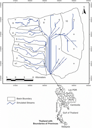
The Upper Ing Basin is located in the Muang and Mae Chai districts of Phayao Province, Thailand. It extends approximately from 19° to 19°35′N and from 99°40′ to 99°55′E and covers approximately 462 km2 (). The river and streams permanently hold water, and flood during October. However, most of the small streams have intermittent flow and do not hold water during a large part of the dry season (Sattarasart Citation1999).
Fig. 1 Location of the study area.
The Ing River flows southward to Phayao city and then northeast until it flows into the Mekong River. The area is situated within the monsoon region of South-East Asia. The prevailing winds follow the continental pattern. That is, there are monsoon winds from the northeast in the winter, distinct southwest monsoon winds in summer, the Inter-Tropical Convergence Zone and tropical cyclones. The climate here is of a sub-tropical type characterized by three separate seasons (Sattarasart Citation1999). The hot season, which starts with the cessation of the northeast monsoon, runs from mid-February to mid-May. The southeast monsoon, which is the dominant wind for this season, originates from the South China Sea. It gradually displaces the cold northeast monsoon in February. The position of the sun and the fact that larger continuous cloud systems are practically non-existent, make this the hottest season in the study area, with temperatures exceeding 40°C in April. The rainy season occurs between mid-May and mid-October. This period is characterized by frequent heavy rainfall, high humidity, substantial cloud presence and tropical temperatures. In May, the winds change direction, blowing from the southwest, and carry along moist air masses which produce heavy rainfall. The southwest monsoon is the result of the formation of moist air masses over the Bay of Bengal. In general, it produces heavy rainfall from mid-May until mid-October, with the most intense rainfalls in August and September. The annual rainfall pattern is bi-modal, with approximately 90% falling during the rainy season. The cold season, which coincides with the northeast monsoon winds, normally runs from mid-October until mid-February. It is characterized by relatively little rainfall, low humidity, minimal cloud cover and low temperatures. The average annual rainfall in Phayao Province was about 1061 mm between 1981 and 1994, with two peaks: in May and September. The average number of rainy days is 117, with the maximum occurrence of rainy days in August. Evaporation is very high: about 177 mm in the hottest month of April.
Available information from the Royal Forest Department indicates that by 1992, about 40.0% of the land in Phayao Province was forest land, 24.2% farm land and 35.8% classified as other. Records from the Royal Irrigation Department indicate that 23.6% of the farm land was irrigated land and the rest is classified under non-irrigated and communal irrigation systems. Paddy production accounts for about 60% of the cultivated land. Field crops, fruit trees and vegetable cover 26%, 7% and 2% of the total cultivated area, respectively (OAE Citation1994, Citation1995). Double-cropping is practised along the river where water is available during the dry season. At the same time, the area under field crops and fruit trees has steadily increased. This indicates a gradual change in concept from the mono-culture of paddy cultivation to a multi-cropping pattern. In the river valleys, the land is fertile and is used to cultivate vegetables and fruit trees, but the great majority is under paddy rice cultivation. The upland zones are too uneven and infertile for rice cultivation, and are used for fruit trees and other field crops.
2.2 The spatial water budget model (SWBM)
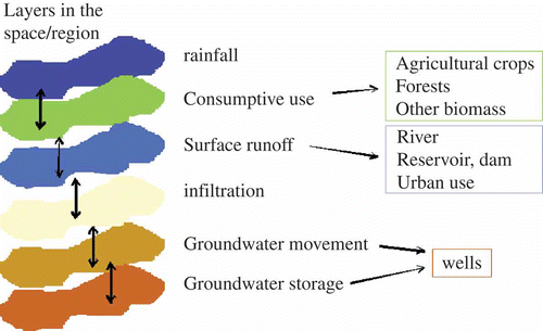
The SWBM includes interactions between all the sectors and processes influencing the water in a region, and balances the water system over time and space. gives an abstract presentation of several layers of the region, which together allow the quantification of the water situation based on the determinants of water availability. The SWBM is a basin-scale model with continuous, distributed parameters for simulating water supply and demand over space and time. This is done on a daily basis using GIS data structures (Luijten et al. Citation2000a, Citation2000b). The model was designed for analysing temporal and spatial variations in the overall water balance, streamwater flow rates and water availability on a daily basis at the basin scale. The processes that are simulated by the SWBM are as follows: (1) land unit water balance, (2) water flow to streams, (3) streamwater flow balance, (4) water storage in small reservoirs, and (5) water extraction from dams, reservoirs and streams for domestic, agricultural and industrial uses.
Fig. 2 The layers in a region of different determinants of water availability.
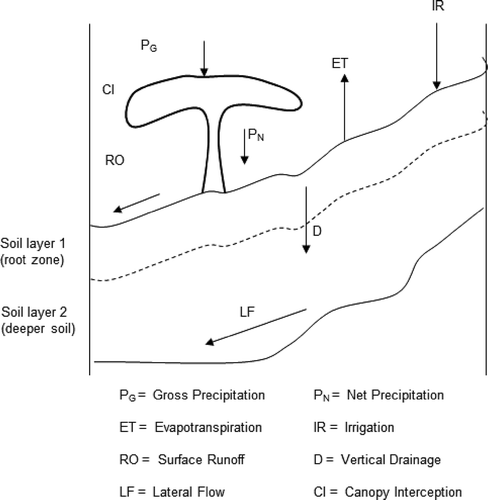
2.2.1 The land-use water balance sub-model
This sub-model deals with the soil water content in the root zone. A grid of square land-use pixels represent the landscape: is a schematic representation of the soil profile of a single land-use cell, and indicates the major processes that are simulated. For any land-use cell, j, the daily change in soil water content in the soil root zone is:
Fig. 3 Schematic representation of the soil profile for a single land unit (adapted from Luijten Citation1999).
where SW j is the soil water content in the root zone (m3 m‐3), PN ,j is net precipitation (mm d‐1), IR j is applied irrigation (mm d‐1); CI j is rainfall intercepted by the forest canopy (mm d‐1); AET j is actual evapotranspiration (mm d‐1); RO j is surface runoff (mm d‐1); Dj is water drainage to the deeper soil layer (mm d‐1); RD j is the rooting depth (in mm); and Δt is the time step of one day.
All processes are modelled on existing knowledge about these processes and use relatively simple empirical relationships (Luitjen, Citation1999). Three processes are particularly important for an understanding of the effect of land cover change on streamwater availability and the overall water balance: canopy interception, evapotranspiration and surface runoff.
Canopy interception, CI j (mm d‐1) is estimated from gross precipitation, PG,j (mm d‐1) on a daily basis using a simple model based on Bruijnzeel and Wiersum (Citation1987):
where A ref,j and B ref,j are parameters (mm) that represent the ability of the canopy of land-use type to intercept water. Parameter A ref,j is equal to or greater than zero, and represents the necessity for some precipitation to occur before throughfall commences. Parameter B ref,j is the fraction of rainfall that can still be intercepted after throughfall has started. Both parameters are multiplied by a crop coefficient, CF j , to account for possible variation in interception capability throughout the year. The difference between gross precipitation and canopy interception is net precipitation (PN ,j ).
Daily evapotranspiration, ET, depends on radiation, minimum and maximum temperatures, stage of plant development, soil water status and canopy wetness. The maximum ET of the actual land cover, MET j (mm d‐1) is calculated as:
where RET j is the reference ET, calculated using the Ritchie (Citation1972) implementation of the Priestley-Taylor equation (Priestly and Taylor, Citation1972), which requires daily radiation and minimum and maximum temperatures. Doorenbos and Pruitt (Citation1977) introduced the concept of crop coefficients to relate actual crop evapotranspiration to a reference evapotranspiration and the crop development stage. Crop coefficients represent the ability of the land cover to reach reference ET.
Canopy storage is depleted to meet evaporative demands before soil water is taken. Canopy storage is generally evaporated at rates higher than the maximum evapotranspiration because of advection (Calder Citation1982) and low aerodynamic resistance of wet canopies (Rutter Citation1967). The literature provides a range of values by which wet canopy ET exceeds the maximum rate, usually 1.5–2.0 (Calder Citation1982, Schulze and George Citation1987). The SWBM applies a fixed and conservative value of 1.3 to forests only (Luijten Citation1999). If the canopy is dry and the volumetric soil water content lies between the critical value and the wilting point, then MET is reduced linearly with the water content for all land cover types (for details see Luijten et al. Citation2000a).
2.2.2 The surface runoff sub-model
Surface runoff is calculated daily on a land-use cell basis with the SCS curve number method (USDA SCS Citation1972) and is modified to account for antecedent soil moisture condition (Heatwole et al. Citation1987). Assuming that the root zone soil is equally moist, that infiltration water can be redistributed throughout the root zone on a rainy day, the volume of surface runoff, RO j (mm d‐1) originating from land-use pixel j is given by:
with
where Sj is the basin storage parameter (mm); CN j is the SCS curve number for antecedent moisture conditions I (i.e. a relatively dry soil); SW j , SAT j and WP j are the actual water content, water content at field saturation and water content at wilting point (m3 m‐3), respectively; and PN,j is net precipitation (mm d‐1).
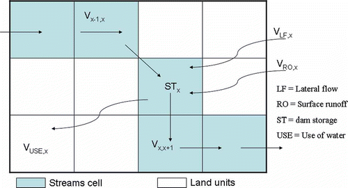
2.2.3 The streamwater flow balance sub-model
Streams are a core feature of the SWBM and are represented by a series of connected grid cells (), each of which receives an accumulated flow beyond some threshold. Streamwater is assumed to flow sufficiently fast so that water input into the stream at any point in the basin will reach the basin outlet within a day, a reasonable assumption for a small hillside basin. The streamwater balance is calculated using daily flow volumes.
Fig. 4 Representation of a stream in a raster GIS and components of a streamwater balance (adapted from: Luijten Citation1999).
The amount of water that flows downstream from stream cell x (x = 0, 1, 2, …) (in m3 d‐1) is:
where Vx -1,x is the water volume that flows from the neighbouring upstream stream cell, x–1, to stream cell x; V RO,x and V LF,x are the accumulated amounts of, respectively, surface runoff and lateral flow into stream cell x from adjacent land units; V USE,x is the daily volume of water extracted from stream cell x to meet water demands; and ΔST x is the change in storage in stream cell x if that cell has a dam. All terms of the equation are expressed in m3 d‐1.
2.2.4 The water flow to streams sub-model
All surface runoff and lateral flow in the deeper soil are assumed to end up in a stream and eventually reach the outlet of the basin.
Surface runoff, RO j from a land unit j flows directly into the first compartment of the distributed delay, SFW j (1) (m3) each day. A constant fraction (SFWRT) of the water stored in the first compartment then flows into the second compartment, SFW j (2) (m3) each day. Water from the second compartment of each land unit flows into the stream using the same constant fraction per day of the amount in that compartment. The equation for the flow of the surface runoff into the stream cell x (m3 d‐1) can be expressed as:
where Qx is the total number of land units that form the contributing area of stream cell x, i.e. not including the contributing area of adjacent stream cell x–1. The surface water retention factor SFWRT used is between 0 and 1, and allows one to control the characteristics of release of surface runoff into the streams.
Lateral flow of drainage water to the stream is modelled similarly to surface runoff. Drainage from a land unit j in to the first compartment of the distributed delay, DRW j (1) (m3) is a daily fraction (RZDRF) of the amount of drainable water in the root zone. A fraction DRFRC j (1) of the amount of water stored in the first compartment then flows into the second compartment, DRW j (2) (m3) each day. Finally, another fraction DRFRCj(2) of the amount of water stored in the second compartment of each land unit flows into the stream. The lateral flow that enters stream cell x on each day is estimated by:
where Qx
is the same as in Equationequation (8)(8). The drainage fractions DRFRC
j
(1) and DRFRC
j
(2) are dependent on the amount of water that is stored in the first and second compartments of land unit j, respectively.
2.2.5 Model establishment and implementation
The SWBM for the Upper Ing Basin is based on the model developed by Luijten et al. (Citation2000a) and runs on a Windows operating system using ArcViewGIS V3.2 software (ESRI Citation1997) with the Spatial Analyst extension. Routing and accumulation of water as it flows down slope was computed using the Flow Direction and Flow Accumulation functions. Simulation results, which were saved in ARC/INFO formatted grids and in dBase files, were processed using spreadsheet software.
2.3 Database development
The SWBM required input data on topography, weather, basic soil properties and land use. A digital elevation model (DEM) was needed for raster-based hydrological analysis in GIS. First DEMs for the Upper Ing Basin were created by digitizing existing 20-m contour maps. After the interpolation (surfacing), a smooth and noiseless 25-m (16-bit) grid DEM was obtained. The 16-bit output DEM was re-scaled to 8-bit to match the radiometric resolution of Landsat TM data, while working in ERDAS (ERDAS Citation1997, Bahadur Citation2009a, Citation2009b). The DEM was exported to ArcViewGIS and afterwards topographic depressions (sinks) were filled, and the direction of surface flow and flow accumulation were prepared using a hydrological modelling extension of ArcViewGIS with spatial analyst and 3D extensions (ESRI Citation1996).
Land-use data were prepared from satellite images of the study regions from Landsat Thematic Mapper (TM), SPOT and Quick Bird. Land-use data were obtained through employing several unsupervised and supervised classification methods (Bahadur Citation2009b). A maximum-likelihood classification of a Landsat TM image from 1995 was carried out. This classification consisted of five different land uses. Most forest land and upland cultivation can be found in the mountainous region of the basin, whereas the lower part has intensive paddy rice cultivation areas that are virtually exposed soil during winter/dry seasons. Soils of the basin can retain water very well (Sattarasart Citation1999). Volumetric soil water contents at wilting point (WP), drained upper limit (DUL) and saturation (SAT) were needed for the calculation of the land unit water balance. Crop water requirement, evapotranspiration, soil water content, canopy interception and root depth for different crops were used as published by FAO (Doorenbos and Pruitt Citation1977). In this study values of WP = 0.35, DUL = 0.46 and SAT = 0.56 cm3 cm‐3 were used, based on those used by Luijten et al. (Citation1999, Citation2000b). These parameter values were applied uniformly over the basin because there were no spatially variable data. This condition is typical of the mountains of Asia. Soil map data on soil depth at the sub-group level showed that soils were generally deep enough to allow roots to grow freely and reach the depths. Thirty years worth of weather data from Phayo provincial metrological station were used. Average monthly temperature and precipitation data for the period 1998–2007 from the Royal Metrological Department of Thailand were used (). Weather data consisted of daily rainfall. Minimum and maximum temperatures and solar radiation were generated using the Weatherman software (Pickering et al. Citation1994) to complete the weather data set.
Table 1 Average monthly precipitation (mm), maximum and minimum ( C) temperature (1998–2007) in Upper Ing Basin, Thailand
2.4 Assessment of the spatial water availability for the different gradients of the basin
The possibility of harvesting irrigation water at different spatial locations of the basin through new small reservoirs, and their optimal spatial allocation, were assessed. Although there are some reservoirs, irrigation structures and canals in the basin, only about 30% of the basin area, mainly in central and eastern parts, is even partly irrigated. The remaining areas do not have irrigation facilities. Farmers reported that there was not enough irrigation water for paddy fields during the monsoon season. Clearly, the shortage of irrigation water is one of the biggest problems of the basin. Families whose farms do not have irrigation facilities are forced to underuse resources, leading to personal loss of income, as well as to wider economic and social losses. The assessment of spatial water availability on different spatial gradients of the basin should therefore focus on the identification of possible locations for constructing small water reservoirs to provide some of the irrigation water. The spatial water budget model established for the study areas shows that the landscape and the hydrological situation of the Upper Ing Basin are unique. A number of sub-catchments can be seen in this basin and most of them are independent catchments. Thus, it may not be possible to supply water harvested in one sub-catchment to other sub-catchments; it can only be supplied to lower-elevation areas which are somehow already irrigated. In order to capture this spatial variability of the basin and to fulfil the irrigation need of agricultural land located within each sub-catchment, there should be a small reservoir where water can be harvested during the monsoon season for irrigation use during winter/dry seasons.
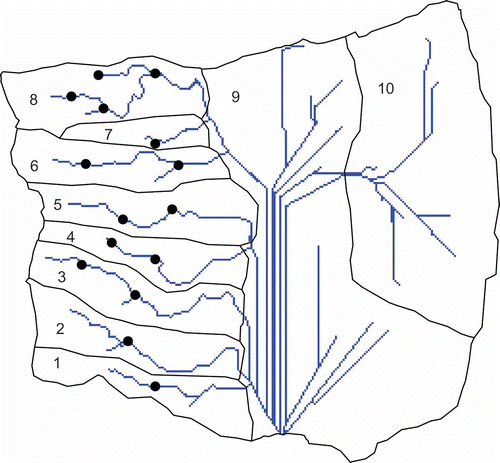
However, agricultural lands are located at different elevations, and it would not be economical to construct a dam at low elevation to irrigate the agricultural land at altitudes above the dam. In order to address this problem, the basin area was divided into 10 zones () based on the simulated stream network and the present situation. Suitable locations for constructing small reservoirs to collect the rainwater during the monsoon season were proposed. An assessment of the hydrological operation was carried out to determine how much water could be collected. Water use in the Upper Ing Basin was quantified and simulated. Two specific simulations were analysed: (1) the reduction in flow rate of the river after water use, and (2) the percentage of available water that was extracted every day. Analysis of dams involved simulating hypothetical dams to illustrate their impact and potential benefits in regulating river flow rates. Two objectives were considered in modelling the operation of dams. First, the river flow rate (after water extraction) had to be sustained during the dry season. Second, high flow rates on rainy days in the wet season had to be reduced. Simulation results were used to calculate the minimum dam storage capacities needed to meet these two objectives of minimum flow rate required and maximum flow rate allowed.
2.5 Impact assessment
Problem-solving strategies are complemented by simulations and assessment of future developments that do not follow any strategy either of farmers or of agricultural policy decision makers. Instead, simulation follows the rules of a free market, or the consequences of changing conditions of the farming families' environments. Such potential developments are also crucial for determining possible dangers in the future, and indicating the consequences of negative developments, such as: the impact of deforestation on agricultural land use, possible changes in agricultural land use or cropping patterns, or changing rainfall, and their impact of on spatial water availability, all of which were simulated and presented.
3 RESULTS
3.1 Characteristics of the model and their implications
A spatial water budget model for the Upper Ing Basin was established. Simulated streams networked by the model during the rainy season were compared with the streams indicated on a topographical map. The simulated stream networks matched well with the mapped streams, which demonstrated that the model is capable of simulating the water availability in the region. Water flows at different outputs of the basin were estimated. River flow and possible water extraction through storage in reservoirs, or directly from the stream, were estimated for different parts of the basin. Although the model is not yet calibrated, the results show that it has good capacity in that it can estimate possible river flow and baseflow and possible water extraction in the different spatial locations of a basin based on topographical, land-use and meteorological data. The model itself will be useful for institutions and people who are interested in spatial water availability and water-use modelling in general. Furthermore, it will be very useful to the provincial irrigation authority for developing and/or planning future strategies to solve the irrigation water problems based on the assumed cropping system and expected weather data, since the model has the capacity to simulate situations throughout the calendar year according to weather data. Future weather data can be simulated through weather data extraction methods based on long-term past meteorological data, and possible spatial water availability at different times of the year can be estimated.
3.2 Simulated river flow at the basin outlet
Simulated river flow from 1998 to 2007 showed high peak flows and fairly rapid retention of surface runoff (). The thicker, smoother line indicates the baseflow component of the river flow. The difference between the river flow and the baseflow is surface runoff. Streamflow showed a somewhat “flashy” behaviour, i.e. high peaks and low minimum flows. This is typical of small mountainous basins (Black Citation1996). River flow easily doubled during short periods after strong rainfall events, whereas it decreased rapidly in the dry season. There was hardly any surface runoff from November to March.
Fig. 5 Basic simulation of the water flow at the outlet point of the basin.
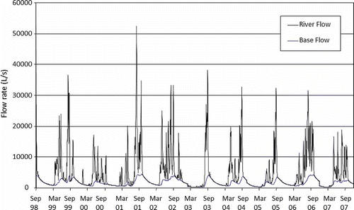
The simulated average annual river flow rates in the years 1998–2007 were: 3.71, 5.48, 4.16, 5.69, 6.04, 3.14, 4.34, 3.19, 5.62 and 3.46 m3/s, respectively. The ten-year average was 4.355 m3/s. The lowest river flows at the end of the dry season were: 103 L/s on 28 May 2003, 129 L/s on 14 April 1998 and 139 L/s on 3 April 2007. Long-term flow measurements of the Ing River indicated that minimum flows normally occur from March to early May. The simulated occurrence of minimum flows of the Upper Ing Basin in the years 1998–2007 occurred a little later than usual. This could be because the simulated years had longer than average dry periods and below average rainfall. Consequently, the soil was drier than usual when the rain started. The first rains after a dry season resulted in little surface runoff and low infiltration of the deeper soil layer. This may take several weeks, depending on the intensity and frequency of the first rains, and whether the soil is dry.
3.3 Temporal variation in stream network
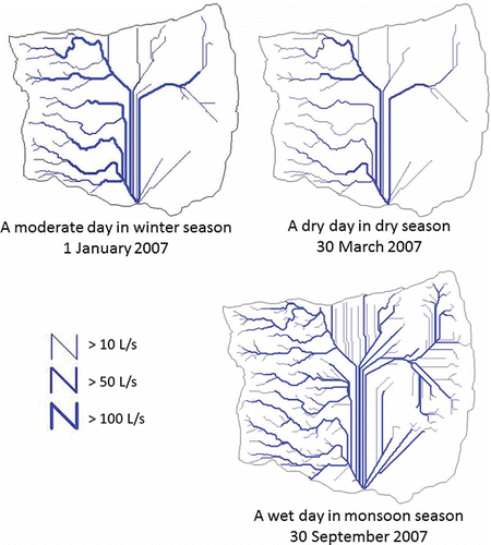
The location and size of the stream network varies throughout the year. Most streams in the basin originate at monsoon. Some streams may dry up during part of the year when monsoons cease. Streamflow may also occur owing to surface runoff. Streams will become longer and start at higher elevations if precipitation intensity increases or if rains last longer. The SWBM model can characterize these stream dynamics. Any grid cell is considered to be a stream cell if its flow exceeds some threshold value. A threshold of 10 L/s was used to demonstrate differences in the stream network for the Upper Ing Basin. The resulting stream network compares well with streams in existing maps and is a good reflection of the numerous small streams that can be found in the basin. shows the stream network on, respectively, a wet day in the wet season (high river flow), a dry day in the wet season (moderate river flow), and a dry day in the dry season (low river flow). The location of streams, in particular their starting points, varies considerably over time. When it is drier and flow rates are low, the accumulated length of all streams and the stream density are low, and the average distance to the closest stream is high.
Fig. 6 Simulated water flow to demonstrate the fluctuation in the rivers of the basin over time in the basic model.
3.4 River flow in different parts of the basin (1998–2007)
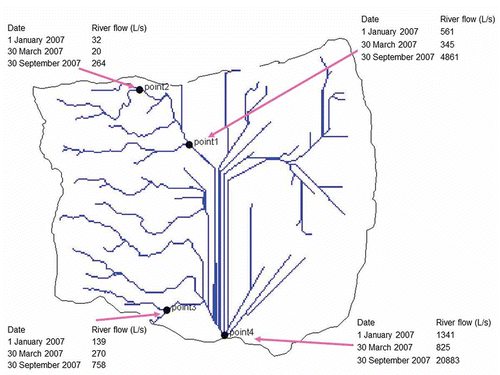
Simulation of river flows in different parts of the basin is shown in , which indicates the simulated river flow as a function of flow length to the basin outlet on a wet day in the wet season (high river flow), a dry day in the wet season (moderate river flow), and a dry day in the dry season (low river flow). Depending upon the output location, its distance from the origin of the stream and the season, the consequences will be a high rate of river flow on a wet day and a low rate of river flow on a dry day. The cumulative effect of the origin of all streams and the length of flow to the basin outlet can be seen impacting on flow at the basin outlet. This effect on different days can be seen in .
Fig. 7 Fluctuation of water flow in the rivers of the basin over time in the basic model.
3.4.1 Water yield of different zones and its spatial variation
Differences in land cover and topography among the seven zones resulted inter alia in variation in the average slope and curve numbers between zones. These variations caused differences in per hectare water yields from each zone throughout the year (). A relative water yield of 100% means that the per-hectare water yield of a zone is equal to the average per hectare water yield of the entire basin in that period. Zones 1 and 2 showed most variation over time. These zones contain most of the rain-fed land and exposed soil. Consequently, less water was lost through evapotranspiration and relative water yield was highest among these zones. Zone 9 has the lowest water yield compared with other zones because of the presence of more forests. The evapotranspiration of forested areas is higher than that of areas with different land cover, resulting in lower water yields. The steep slope caused fairly rapid water flow to streams, resulting in little baseflow towards the end of the dry season.
Table 2 Zone-wise average water yields (L s‐1 km‐2) based on daily simulated flows
The distribution is very narrow, indicating that the relative contribution of any part of the basin to streamflow does not vary much over time. Over a longer term, the upper and lower areas of the basin contribute nearly equally to river flow. However, the upper and lower areas vary with respect to how they contribute to river flow, i.e. via surface runoff or via lateral flow. Surface runoff contributes more to river flow in the lower areas than in the upper areas. This difference in water yield is caused by differences in land cover. Nearly all exposed soil and paddy fields can be found in the lower areas and most forest is in the upper areas (see land-use maps). Changes in land management can thus affect how the different parts of the basin contribute to river flow.
3.4.2 Spatial water availability in different spatial gradients of the basin
The results of analysing the optimal locations of reservoirs for potential water harvesting are presented in . In each zone, at least one reservoir is proposed and based on the available river flow information from the SWBM. The location of the reservoir has been selected in such a way that the possible water collected from the reservoir can be made available for irrigation in that zone. Since one reservoir within a zone may not be able to collect enough water to irrigate all the agricultural land downstream and upstream of this zone, more than one reservoir is suggested in zones 3, 5, 6 and 8 (). The locations of the reservoirs are based on the possibilities of water harvesting and the amount of irrigation water needed. Most of the agricultural areas located close to the proposed reservoir are currently not irrigated. After the appropriate location of a reservoir had been identified, the possible quantity of water that could be harvested from that reservoir was estimated. An assessment was carried out to find out the quantity of water that could be collected during the monsoon season using the dam operation and the management capabilities of the spatial water budget model, as described in Section 2.4.
Fig. 8 Optimal locations of reservoirs for potential water harvesting (indicated by black dot).
3.5 Effect of changes in land-use patterns and climate
3.5.1 Deforestation scenario
Deforestation is one of the most drastic ways to change land use. Such a radical change will have implications for the water cycle. In order to see the impact of land-use change through the cutting down of forests on spatial water availability, this scenario quantified the consequences on water resource availability and its potential use as groundwater or surface water. Compared with the situation without cutting down forests, in this scenario it was assumed that all the remaining forest land was converted into agricultural land. All the hydrological characteristics including critical soil content, root depth, crop water requirement and canopy interception, among others, were modified accordingly and used in the simulation. Deforestation removes the biomass of the forests, and rainfall behaves differently. The forest provides more time for the water to find its way to the soil, so higher runoff of the water can be expected and less percolation into soil and groundwater may occur. The model that simulated deforestation conditions at basin outlets showed high peak flows and fairly rapid retention of river runoff. This can be seen from a comparison of the water flows under present conditions (no deforestation) and after deforestation (). The total river flow is composed of base river flow and river runoff. The difference between total river flow and base river flow is considered as river runoff.
Fig. 9 Simulated river flows: current and “deforestation” scenarios.
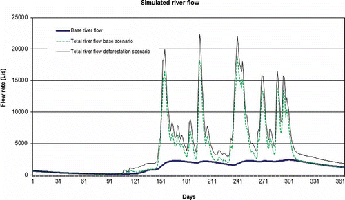
The river flows showed high fluctuations, far exceeding the base river flow. The simulated average annual river flow rate for the “deforestation” scenario at the basin outlet was 4.426 L/s which was significantly higher than the base scenario (3.468 L/s). Although the overall trend of river flow looked the same as in the base scenario, the amount of peak flow exceeded 20 000 L/s compared with about 18 000 L/s in the base scenario.
When forests are cut down, more surface runoff water is available in the entire simulation period, particularly during the peak periods of rainy seasons. To use this additional runoff water for irrigation, it has to be collected and stored, which requires investment. In the case of existing forests, more water will go to groundwater. Water will flow underground if the geological structure is suitable, or it will be stored when it cannot flow away. In the latter case, nature acts as a storage basin and is free of storage cost. Often, however, such storage can only be accessed by additional investment in wells and pumps.
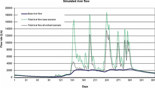
3.5.2 Orchard scenario
Similarly to deforestation, any change of land use in agricultural areas will have an effect on the hydrological system in the basin. This is of special importance for changing cropping systems. The effect of changing land use was measured in two extreme scenarios which together with the current situation enabled estimation of the effect on the hydrological cycle and water availability for irrigation. In order to see the possible impact of agricultural land-use change on spatial water systems in this scenario, different conditions of agricultural land use were assumed. In this scenario all agricultural land was used for orchards, instead of in a combination of orchards and paddy rice, as under the existing conditions. This means all rice fields were cropped with fruit trees. All the hydrological characteristics including inter alia critical soil content, root depth, crop water requirement, and canopy interception were modified accordingly.
The river flows showed high fluctuations, considerably decreasing the base river flow (). The simulated river runoff for the “growing orchards” scenario was much less than that under the current land-use system (with paddy rice) owing to lower total river flow. This means that less of the rainfall is running away and is retained by the orchard. The simulated average annual river flow rate at basin outlet was 2352 L/s, which was much lower than in the base scenario (3468 L/s). Although the overall trend of river flow looks the same as in the current situation, the amount of peak flow will be reduced to 13 000 L/s compared with about 18 000 L/s in the base scenario (). Orchard scenarios gave very different simulation results because annual ET increased and this was caused by the orchards' ability to intercept rain and to extract water from deeper soil. Because of the increased ET, less water was left as surface runoff and baseflow.
Fig. 10 Simulated river flows: current and “all orchard” scenarios.
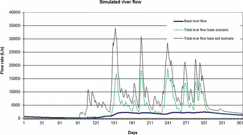
3.5.3 Bare soil scenario
In the bare soil scenario no areas of the basins were used (as a control scenario) in order to show the impact of different land uses to regulate the water system in the basin in comparison with the current situation. In this scenario, the impact of different ground covers including forest trees, orchard and agricultural crops for the regulation of the water system in the basin was simulated and quantified. All the hydrological characteristics including inter alia curve number, critical soil content, root depth, crop water requirement and canopy interception, were modified accordingly.
Simulated river flow for the “unused land” condition showed high peak flows and fairly rapid retention of surface runoff as in the base scenario. Streamflow showed a somewhat flashy behaviour, as in the situation with current land use, where high peaks and low minimum flows were found. The simulated average annual river flow rate for the “bare soil” scenario was 6733 L/s at the basin outlet, which is extremely high compared with the base scenario (3468 L/s). This is because in the scenario under current land-use conditions all the biomass of the crop cover was conserving, utilizing and interrupting the water in different forms and at different times and situations compared with the bare soil condition. This highlights how important it is to have sound ground covers in a basin to regulate water systems. Although the overall trend of river flow looks similar to the scenario in the current land-use system, the amount of peak flow could reach about 35 000 L/s in the “unused land” scenario compared with about 18 000 L/s under current land-use conditions ().
Fig. 11 Simulated river flows: current and “bare soil” scenarios.
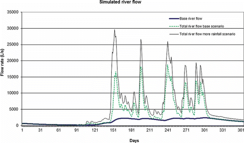
3.5.4 Increased rainfall scenario
Another determining factor of water availability in a basin or region is the amount and distribution of rainfall. This scenario quantified the effect of changing rainfall on the water system and water availability for irrigation. In order to show the possible impact of uncertain future weather conditions on spatial water availability and water systems in the Upper Ing Basin, the possible impact of increasing precipitation on spatial water availability was simulated. An increase of 20% of historical rainfall was assumed: based on the weather data of the base year 2007, for all days on which there was rain in 2007 the amount of rainfall was assumed to be increased by 20%.
Simulated river flow for the “increased rainfall” scenario showed high peak flows and fairly rapid retention of river surface runoff as in the base scenario. Total river flow showed high fluctuations which were much higher in the increased rainfall scenario than under current conditions. The simulated average annual river flow rate for the increasing rainfall was 5306 L/s at the basin outlet which is higher than for the base scenario (3468 L/s). Although the overall trend of river flow looks the same as it is in the base scenario, the amount of peak flow is projected to reach almost 30 000 L/s compared with about 18 000 L/s in the base scenario ().
Fig. 12 Simulated river flows: current and “increased rainfall” scenarios.
One of the interesting aspects of changing climate and increasing rainfall in the mountain areas of South-East Asia is the potential effect on water harvesting and the increase of irrigated land. The possible quantities of water that can be harvested from more rainfall were estimated in the same way as in the base scenario, and the possible cropping system, in particular vegetables and orchards, was estimated. Areas that could be irrigated under the increased rainfall scenario compared with the base scenario were estimated by assuming that orchards need the irrigation water during the dry season only, and 0.06 m3 s‐1 km‐2 is required for at least 150 days. Vegetables were assumed to be grown during the dry season, needing 0.075 m3 s‐1 km‐2 of water for 90 days. The orchard and vegetable areas in the base and increased rainfall scenarios were estimated and compared.
The results showed that harvested water under the increased rainfall scenario could be used to irrigate 1.5 times the current vegetable and orchard area. Some 50–100% of the agricultural land in some zones could be put under orchard or vegetables in the increased rainfall scenario. The results are presented in .
Table 3 Comparison of the water harvest and agricultural area that can be irrigated in the “increased rainfall” scenario compared to the base scenario
4 CONCLUSIONS AND DISCUSSION
Neither the SWBM nor the ArcView GIS software put any restrictions on the grid-cell size, the total area of the basin, or the time period that could be simulated. These settings should be carefully considered, however, before any simulation exercise is undertaken because of the following. First, the SWBM does not delay streamwater flow. All water that enters the stream is routed towards the basin outlet on the same day. Therefore, if the SWBM is applied to larger basins it may provide a less accurate estimate of the day-to-day variation in streamflow at the basin outlet. The model would then be more appropriate for analysing variation in water availability over a longer time, for example, on a weekly or monthly basis. Secondly, a grid cell must be sufficiently small to avoid loss of information through aggregation and misrepresentation of the landscape (Luitjen et al. Citation2000b).
As Luijten et al. (Citation2000b) mentioned, two key aspects distinguish the SWBM from many other hydrological models. First the model's strength is its accounting for streamwater as it flows down slope to the basin outlet. Specifically, the SWBM can simulate water input in streams over space and time, and streamflow control using dams and water use from streams and impoundments. Secondly, the SWBM was intended to help reduce some of the complexity associated with the interdependencies between land and water resources and spatial linkages within the basin, and to help provide information on such spatial relationships to support local decision-making processes and educate local stakeholders.
Simulated flows for the Upper Ing Basin changed significantly over space and time between 1998 and 2007. River flow rates at the end of dry seasons in those years were between 27% and 43% of the average annual river flow rates, whereas flow rates more than doubled during strong rainfall events owing to surface runoff. Because SWBM is a distributed parameter model, it was able to determine that per-unit water yields of the 10 zones in the basin varied from approximately 50% to 137% of the average water yield for the entire basin. This significant range was caused by differences in topography and land cover among the zones. The hydrological responses of uniform and mixed cropland, forest and bare soil, as well as those due to more rainfall were very different as well. Although uniform land uses and bare soil are unlikely extremes, they were valuable for educating local stakeholders about the functions of the landscape and the effects of different land uses on water yields.
Improving water supply throughout the year is the least relevant strategy in terms of future development. It would require financial and managerial efforts which would be too general to achieve particular economic effects. There is an urgent need to differentiate requirement according to time. For lowlands with paddy rice production an investment in hydrological infrastructure to provide irrigation water to the farmers continuously throughout the year is economically and socially unjustifiable. Under these conditions it is urgently suggested that water from the rainy season should be stored and used in the dry season. New dams need to be managed under a strategy of providing water in the dry season. Since many areas are still in need of some irrigation water for agriculture even in the rainy season, as well as supplementary irrigation for fruit trees in the dry season, the general water supply could be improved in those areas for all seasons throughout the year. Instead of large dams, a set of small water reservoirs for smaller sub-basins at higher altitudes is suggested. This allows higher efficiency in water harvesting; smaller distances from the water reservoir to the fields; and better use of gravity for distribution, even in piped systems. The strategy of small reservoirs with efficient water-harvesting potential and close links to farms in the mountain zone could also function as a structure to control water runoff and river streams. It would allow regulation of the upstream and downstream conflict and related problems in the whole Upper Ing Basin, as well as mitigate soil erosion and landslides.
Improving water supply in dry seasons should be the main water supply strategy in the future. Irrigation in the dry season allows the use of available resources twice a year. Land is very scarce in those zones and it is not used in the dry season owing to lack of water. At the same time, labour is available, low employment being the norm in the dry season. Making water available in the dry season would allow land, labour and also capital resources to be used more efficiently. This would benefit farming families, as well as improve income at the national level, leading to an increase in the Gross National Product. In the dry season, less rainfall is available and this means more irrigation water is needed. Even if the water-use efficiency is lower in the dry season, the economic benefit is higher and justifies water use in the dry season (Doppler et al. Citation2009).
Several human activities interfere with the water cycle in the region; for example, deforestation leads to different conditions in the basin and, hence, the amount of water available for irrigation is altered. In mountains, deforestation will lead to an increase in surface runoff when rain falls, so that, rivers have—for a short time—more water to transport, and while this water will be available briefly for storage in reservoirs, less water will go to groundwater to be stored naturally. If groundwater use decreases, surface water use will need more investment in storage. The use of groundwater in farming zones will decrease, which means a strategy for cheap water storage and transport by nature can no longer be used. At the same time, groundwater use is very often organized by individual farmers through their own investment. Increased surface water offers opportunities for high investment in reservoirs. The environmental consequences are the increasing danger of erosion, landslides and infrastructure damage, which requires additional economic effort by farmers to protect farmland from both erosion and landslides, and by the public authorities to prevent damage to roads, power supply and telecommunications infrastructure. Furthermore, with a reduction in aquifer supply due to reduced groundwater, the possible impacts on the soil as well as on the geological conditions may influence both the ecosystem and agricultural production. For this reason a wide-spread strategy to prevent people from cutting down forests is still needed in the future.
Land-use changes will have an impact on the silting in a reservoir. The annual amount of water is not as affected. but the water level will fluctuate between seasons depending on the crops grown. In this case, land-use regulations are required, and control by public authorities should ensure environmentally friendly farming. In the flat land irrigation zones, land use will affect the demand for water and, through intensification in production, the quality of the drained water. The latter falls not within the remit of the individual farmer, but within that of society. Currently, what happens to the used water after irrigation is not a great concern, as water is simply drained into the rivers. With increasingly intensified agriculture and settlement of people, this issue will lead to an ecological problem of pollution. In the downstream areas, the level of pollution will increase and water quality will deteriorate. In inclined areas of the mountains, crop production is often not as intensive as in flat zones; therefore, water quality is usually not so negatively affected as in paddy rice zones. The type of land use in these areas will affect the runoff, increasing the danger of erosion and landslides. The more cropping systems that cover the land throughout the year (all seasons), the lower the danger of negative effects of water on soils will be, as proper cropping systems can hinder the negative effects of water. An agricultural extension service should inform and support such concepts and train farmers in the use of cropping systems. This will not be easy, since the most environmentally-friendly cropping systems are often not necessarily the most profitable ones.
Spatial water resources management is a big challenge in the mountainous regions of South and South-East Asia. Various methodologies have been attempted to assess the spatial water availability, especially for the irrigation water at the basin scale, which is very necessary for sustainable land and water resources management and socio-economic and comprehensive regional development. However, to make use of them, many of the established models need large sets of data covering weather, soils, slopes, crops and land management in detail. In developing countries, such data are often not available, or require a lot of time, money and effort for preparation of data sets. This paper attempts to assess the strategic water availability in Upper Ing Basin by means of satellite images, GIS tools and a spatial water budget model, despite the lack of some direct observational data. Indirect methods were used to collect the required data on the basin and some parameters were adapted from those used by other researchers in other geographically similar regions. The predicted amount of flow rate and possible amount of water harvesting through the construction of small dams in different spatial locations of the basin provide a basis for the comprehensive spatial water management and sustainable land and water use for the basin studied. As management measures and their impact show that improving water supply throughout the year is not the best way forward, improvement in the dry season should be the main water supply strategy in the future. Human activities interfering with the water cycle should be discouraged.
The methods presented in this paper of assessing spatial strategic water availability despite the lack of some direct observational data could be useful for decision-makers in other parts of the world. Furthermore, an improved model could be applied to spatial water resources management in tropical mountainous regions of South or South-East Asia if all required parameters were included such as detailed soil characteristics from the most up-to-data high resolution soil maps, and if it were validated with observed data.
Acknowledgements
I should like to thank the late Dr Herrmann Eiselen and the Eiselen Foundation, Ulm, Germany, and the University of Hohenheim, Germany, for financial support for this research. I am especially grateful to Werner Doppler for his helpful discussions, encouragement, valuable criticism and constructive comments on an earlier draft of this paper. Jirawan Kitchaicharoen and Tika Yakopadee are acknowledged for their assistance with data collection. I am grateful to reviewers whose valuable comments and suggestions helped to consolidate and strengthen this article. I thank the residents of Upper Ing basin, Thailand, for graciously welcoming me into their communities and onto their farms.
REFERENCES
- Abbott , M.B. , Bathurst , J.C. , Cunge , J.A. , O'Connell , P.E. and Rasmussen , J. 1986a . An introduction to the European Hydrological System—Système Hydrologique Européen, SHE, 1. History and philosophy of a physically-based, distributed modeling system . J. Hydrol , 87 : 45 – 59 .
- Abbott , M.B. , Bathurst , J.C. , Cunge , J.A. , O'Connell , P.E. and Rasmussen , J. 1986b . An introduction to the European Hydrological System—Système Hydrologique Européen, SHE, 2. History and philosophy of a physically-based, distributed modeling system . J. Hydrol , 87 : 61 – 77 .
- Arnold , J.G. , Engel , B.A. and Srinivasan , R. 1993 . “ Continuous Time, Grid Cell Watershed Model ” . In Application of Advanced Information Technologies: Effective Management of Natural Resources. American Society of Agricultural Engineers , 267 – 278 . ASAE Publication 04–93 .
- Bahadur KC , K. Assessing strategic water availability in the Upper Ing Watershed, Thailand . Proceedings of the International Conference on the Competition for Resources in a Changing World. New Drive for Rural Development . October 7–9 2008 , Hohenheim, Germany. Book of abstracts, 475. ISBN 978-3-86727-755–6
- Bahadur KC , K. 2009a . “ Mapping soil erosion susceptibility using remote sensing and GIS. A case of the Upper Nam Wa Watershed, Nan Province, Thailand ” . In Environ. Geology Vol. 57 , 695 – 705 . doi: doi:10.1007/s00254-008-1348–3
- Bahadur KC , K. 2009b . Improving Landsat and IRS image classification: evaluation of unsupervised and supervised classification through band ratios and DEM in a mountainous landscape in Nepal . Remote Sensing , 1 ( 4 ) : 1257 – 1272 . doi: doi:10.3390/rs1041257
- Beven , K.J. and Binley , A.M. 1992 . The future of distributed models: model calibration and uncertainty prediction . Hydrol. Processes , 6 : 279 – 298 .
- Bhaduri , B. , Harbor , J. , Engel , B. and Grove , M. 2000 . Assessing watershed-scale, long-term hydrologic impacts of land-use change using a GIS–NPS model . Environ. Manag , 26 ( 6 ) : 643 – 658 .
- Black , P.E. 1996 . Watershed Hydrology , second , Chelsea, MI : Ann Arbor Press .
- Bruijnzeel , L.A. and Wiersum , K.F. 1987 . Rainfall interception by a young Acacia auriculiformis plantation forest in west Java, Indonesia: application of Gash's analytical model . Hydrol. Processes , 1 ( 4 ) : 309 – 319 .
- Calder , I.R. Forest evapotranspiration . Canadian Hydrology Symposium: 82 . Ottawa, ON. pp. 173 – 193 . Associate Committee on Hydrology, National Research Council for Canada .
- Choi , J. , Engel , B.A. and Chung , H.W. 2002 . Daily streamflow modelling and assessment based on the curve-number technique . Hydrol. Processes , 16 ( 16 ) : 3131 – 3150 .
- Doorenbos , J. and Pruitt , W.O . 1977 . Guidelines for predicting crop water requirements. Rome: Food and Agricultural Organization of the United Nations . FAO Irrigation and Drainage Paper 24 ,
- Doppler , W. , Bahadur KC , K. and Kitchaicharoen , J. 2009 . Water Resources Development and Its Impact on Rural Livelihood in Northern Thailand. Integrating GIS into Farming System Economics , Germany : Margraf . ISBN 978-3-8236-1568–2
- Efstratiadis , A. , Nalbantis , I. , Koukouvinos , A. , Rozos , E. and Koutsoyiannis , D. 2008 . HYDROGEIOS: A semi-distributed GIS-based hydrological model for modified river basins . Hydrology Earth System Sci , 12 : 989 – 1006 .
- ERDAS . 1997 . Earth Resources Data Analysis System (ERDAS) , Atlanta, GA : ERDAS Inc .
- ESRI (Environmental Systems Research Institute) . 1996 . Avenue: Customization and Application Development for ArcView , Redlands, CA : Environmental Systems Research Institute .
- ESRI (Environmental Systems Research Institute) . 1997 . Getting to know ArcView GIS. The Geographic Information System for Everyone , Redlands, CA : Environmental Systems Research Institute .
- Ewen , J. , Parkin , G. and O'Connell , P.E. 2000 . SHETRAN:distributed river basin flow and transport modeling system . J. Hydrolog. Engng , 5 : 250 – 258 .
- Heaney , J.P. , Sample , D. and Wright , L. 2001 . Geographical Information Systems, Decision Support Systems, and Urban Stormwater Management , Edison, NJ : US Environmental Protection Agency .
- Heatwole , C.D. , Campbell , K.L. and Bottcher , A.B. 1987 . Modified CREAMS hydrology model for Coastal Plain flatwoods . Trans. Am. Soc. Agric. Engrs , 30 ( 4 ) : 1014 – 1022 .
- Jain , M.K. , Kothyari , U.C. and Ranga Raju , K.G. 2004 . A GIS based distributed rainfall runoff model . J. Hydrol , 299 ( 1–2 ) : 107 – 135 .
- Li , Z. and Zhang , K. 2008 . Comparison of three GIS-based hydrological models . J. Hydrol. Engng ASCE , 13 ( 5 ) : 364 – 370 .
- Liu , Z. and Todini , E. 2002 . Towards a comprehensive physically based rainfall run-off model . Hydrol. Earth System Sci , 6 : 859 – 881 .
- Luitjen, J.C. (1999) A tool for community-based water resources management in hillside watersheds. PhD Dissertation, University of Florida, USA http://etd.fcla.edu/etd/uf/1999/amp7392/luijten.pdf (http://etd.fcla.edu/etd/uf/1999/amp7392/luijten.pdf)
- Luijten , J.C. , Jones , J.W. and Knapp , E.B. 2000a . “ Spatial Water Budget Model and Hydrological Tools: An ArcView GIS extension ” . In User's manual , Cali, Colombia : Agricultural and Biological Engineering Department, University of Florida and International Centre for Tropical Agriculture .
- Luijten , J.C. , Jones , J.W. and Knapp , E.B. 2000b . Dynamic modelling of strategic water availability in the Cabuyal River, Colombia: the impact of land cover change on the hydrological balance . Adv. Environ. Monit. Model , 1 ( 2000 ) : 36 – 60 .
- Nageshwar , R.B. , Wesley , P.J. and Ravikumar , S.D. 1992 . Hydrologic parameter estimation using Geographic Information System . J. Water Resour. Plan. Manag , 118 ( 5 ) : 492 – 512 .
- OAE . 1994 . Agricultural Statistics of Thailand Crop Year 1993/94 , Bangkok, Thailand : Ministry of Agriculture and Co-operatives (MOAC), Agricultural Statistic no. 16/1994 .
- OAE . 1995 . Agricultural Statistics of Thailand Crop Year 1994/95 , Bangkok, Thailand : Ministry of Agriculture and Co-operatives (MOAC), Agricultural Statistic no. 6/1996 .
- Pickering , N.B. , Hansen , J.W. , Jones , J.W. , Wells , C.M. , Chan , V.K. and Godwin , D.C. 1994 . Weatherman: a utility for managing and generating daily weather data . Agronomy J , 86 : 332 – 337 .
- Priestley , C.H.B. and Taylor , R.J. 1972 . On the assessment of the surface heat flux and evaporation using large scale parameters . Monthly Weather Rev , 100 : 81 – 92 .
- Refsgaard , J.C. and Strom , B. 1995 . “ MIKE SHE ” . In Computer Models of Watershed Hydrology , Edited by: Singh , V.P. Littleton, CO : Water Resources Publications .
- Rewerts , C.C. 1992 . ANSWERS on GRASS: integration of a watershed simulation with a geographic information system (nonpoint source pollution) , USA : PhD Thesis, Purdue University .
- Ritchie , J.T. 1972 . Model for predicting ET from a row crop with incomplete cover . Water Res , 8 : 1204 – 1213 .
- Rutter , A.J. 1967 . “ An analysis of evapotranspiration from a stand of Scots Pine ” . In International Symposium of Forest Hydrology , Edited by: Sopper , W.E. and Lull , H.W. 403 – 417 . Oxford : Pergamon Press .
- Sattarasart , A. 1999 . “ Water resource management and farming systems in Northern Thailand ” . In Farming Systems and Resource Economics in the Tropics , Edited by: Doppler , W. 33 Kiel : Wissenschaftsverlag Vauk .
- Schuize , R.E. and George , W.J. 1987 . A dynamic, process-based, user-oriented model of forest effects on water yield . Hydrol. Processes , 1 : 293 – 307 .
- Schumann , A.H. and Geyer , J. 2000 . GIS-based ways for considering spatial heterogeneity of catchment characteristics . Phys. Chem. Earth , 25 : 691 – 694 .
- Seckler , D. , Barker , D. and Amarasinghe , U. 1999 . Water scarcity in the twenty-first century . Int. J. Water Resour. Devel , 15 ( 1 ) : 29 – 42 .
- Singh , V.P. and Woolhiser , D.A. 2002 . Mathematical modeling of watershed hydrology . J. Hydrol. Engng, ASCE , 7 ( 4 ) : 270 – 292 .
- Todini , E. 2007 . Hydrological catchment modelling: past present and future . Hydrol. Earth System Sci , 11 ( 1 ) : 468 – 482 .
- USDA SCS (US Department of Agriculture, Soil Conservation Service) . 1972 . National Engineering Handbook, Section 4, Hydrology , Washington, DC : US Department of Agriculture, Soil Conservation Service .
- Van Dijk , A.I.J.M. and Renzullo , L.J. 2010 . Water resource monitoring systems and the role of satellite observations . Hydrol. Earth System Sci. Disc , 7 : 6305 – 6349 .
- Zhan , X. and Huang , M. 2004 . ArcCN-runoff: an ArcGIS tool for generating curve number and runoff maps . Environ. Model. Software , 19 ( 10 ) : 875 – 879 .