Abstract
Currently there is much discussion regarding the impact of climate change and the vagaries of the weather, in particular extreme weather events. The Himalayas form the main natural water resource of the major river systems of the Indian region. We present a brief review of the available information and data for extreme rainfall events that were experienced in different sectors of the Himalayas during the last 137 years (1871–2007). Across the entire Himalayas, from east to west, there are now 822 rainfall stations. There was an increase in the rainfall station network from 1947 onwards, especially in the Nepal and Bhutan Himalayas. Extreme one-day rainfall has been picked out for each station irrespective of the period for which data are available. The decadal distribution of these extreme one-day rainfalls shows that there is a considerable increase in the frequencies during the decades 1951–1960 to 1991–2000, whereas there is a sudden decrease in the frequencies in the present decade during 2001–2007, indicating the need to understand the response of the systems to global change and the associated physical and climatological changes. This is essential in terms of preserving this natural resource and to encourage environmental management and sustainable development of mountain regions.
Citation Nandargi, S. & Dhar, O. N. (2011) Extreme rainfall events over the Himalayas between 1871 and 2007. Hydrol. Sci. J. 56(6), 930–945.
Résumé
Actuellement, le débat est intense au sujet de l'impact du changement climatique et des caprices de la météorologie, en particulier les événements météorologiques extrêmes. L'Himalaya accueille la principale ressource en eau naturelle des systèmes fluviaux majeurs de la région Indienne. Nous présentons une brève revue des informations et des données disponibles sur les événements de précipitations extrêmes qui ont été observés dans différents secteurs de l'Himalaya au cours des 137 dernières années (1871–2007). A travers l'Himalaya tout entier, d'est en ouest, il y a désormais 822 stations pluviométriques. Le réseau de stations pluviométriques a augmenté à partir de 1947, en particulier dans l'Himalaya du Népal et du Bhoutan. La précipitation journalière extrême a été sélectionnée pour chaque station, indépendamment de la période de disponibilité des données. La distribution décennale de ces pluies journalières extrêmes montre qu'il y a une augmentation considérable de la fréquence au cours des décennies 1951–1960 à 1991–2000, alors qu'il y a une soudaine diminution de la fréquence au cours de l'actuelle décennie 2001–2007, ce qui indique la nécessité de comprendre la réponse des systèmes au changement global et les changements physiques et climatologiques associés. Cela est essentiel en termes de préservation de cette ressource naturelle et pour encourager la gestion de l'environnement et le développement durable des régions de montagne.
1 INTRODUCTION
The Himalayas are the major source of the three main river systems in south Asia, viz. the Indus, the Ganga and the Brahmaputra. The Himalayan glaciers are freshwater reserves which provide the head waters for these three river systems. About 1.5 × 10⁹ people depend on this huge “water tower” for their life activities. Recently it has been shown that in India there is a significant rising trend in the frequencies of extreme rainfall events while a decreasing trend has been found in moderate rainfall events. Shrestha et al. (Citation2000) and Goswami et al. (Citation2007) have shown that the Himalayas have a tremendous impact on climatic variability, extreme weather events and economic activities such as agriculture, power generation and other infrastructural activities of the Indian region, mainly because the Himalayas present many different climate types within a small areal extent due to their altitudinal range.
The third and fourth assessment reports of the Intergovernmental Panel on Climate Change (IPCC Citation2001, Citation2007) pointed out the critical role of the Himalayas in the provision of water to continental monsoon Asia and also clearly revealed their vulnerability to climate change in terms of their hydrology and water resources. Hence, the study of climate variability and its effects in such areas helps in understanding the climate of the region and its influence on the neighbouring areas.
In the present study, we have attempted to determine the impact of climate change on the extreme one-day rainfall of the Himalayan region, in the context of rising temperatures. As global climate change has direct and indirect effects on human activity (Joshi and Rajeevan Citation2006), it is interesting to study Himalayan climatology with special reference to extreme rainfall events.
2 THE HIMALAYAS AND THEIR RAINFALL CLIMATOLOGY
The Himalayas extends from the Nanga Parbat (8125 m) in the west to the Tsangpo-Dibang bend around Namche Barwa (7755 m) in the east, forming an arc of 2400 km length and width 150–400 km north to south. The world's highest mountains, Mt Everest (8848 m), K2 (8611 m) and Kanchenjunga (8586 m), are located within them. The Himalayas comprise a complex chain of high mountains, elevated plateaus, deep gorges and extended valleys. There are three main ranges ():
| a. | Outer Siwalik range (Southern Himalayas) lying between the Lesser Himalayas and the Indo-Gangetic plans, with average height 900–1200 m a.s.l. and width 1000–5000 m. Fig. 1 Map of the Himalayas showing different ranges and highest peaks. 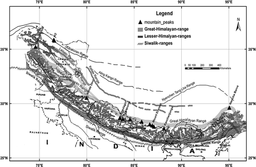 | ||||
| b. | Middle range or Lesser Himalayas (named differently in different sectors), which are a series of broken mountain ranges of mean elevation 3700–4500 m a.s.l. and width about 5000 m. In northwest India, these are called the Pir Panjal ranges and in Nepal the Mahabharat ranges. | ||||
| c. | The Great Himalayan range is the innermost of the highest ranges with perpetual snow and ice whose average height varies from 6000 to 8800 m a.s.l., and which separates the Tibetan Plateau from the Indian sub-continent. | ||||
The loftiest mountain complex of the Himalayas contains 10 of the world's 14 peaks exceeding 8000 m (see ) and 31 peaks exceeding 7600 m in elevation. There are series of narrow chains of high mountains (crest-lines at 5000–5500 m) that are transversed by a number of trans-Himalayan rivers and their tributaries, which play an active role in eroding and shaping the high mountains, producing deep valleys and gorges. These ranges have a profound effect on the climate of the Indian subcontinent and the Tibetan Plateau.
The climate of the Himalayas is alpine in nature, i.e. the climate varies with the elevation. As an example, altitude in the central Himalayas in Nepal varies from 60 m in the south at Terai (foothills of the Himalayas) to 8848 m at Mt Everest, 90–120 km to the north, which causes variation in climate. It gets colder as the elevation increases, and warmer and wetter as the elevation decreases. As a result, the climate in general changes in the different Himalayan sectors rather quickly, which may lead to sudden occurrences of cloud bursts, high winds, snowstorms, etc, resulting in quick floods; the weather is quite unpredictable and at times dangerous too.
The Himalayan ranges form a barrier to the southwest monsoon (hereafter called “monsoon”) winds crossing over to Tibet, thereby causing heavy to very heavy rainfall in the foothills and the adjoining plains of India to its south (Dhar et al. Citation1975, Dhar and Nandargi Citation1998). In addition, the heavy rainfall does not occur in a continuous spell as seen over the plain regions of India, but there can be sudden falls of heavy rain of short (3–4 h) to long (10–14 h) duration.
In the Ladakh, region, situated on the lee side of the western part of the Himalayas, monsoon activity is very weak, e.g. the mean annual precipitation of Leh station is hardly 93 mm, which is less than a quarter of what is received in Lhasa, the capital of Tibet (Dhar and Mulye Citation1987). Whereas stations located in the Pir Panjal range receive far greater rainfall, because they are to the windward side of monsoon disturbances, the Pir Panjal range traps most of the moisture from the monsoon currents as a result of orographic lifting. These monsoon currents have deposited their moisture by the time they cross the 3000–4000-m-high Pir Panjal range and stations located to the lee side receive much less rainfall (Dhar et al. Citation1982a).
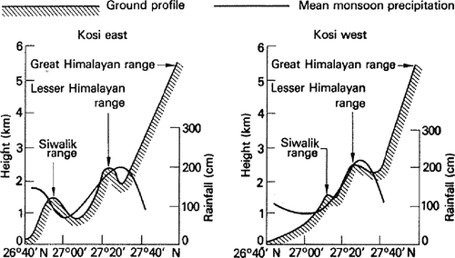
Variation of rainfall with altitude in the Nepal Himalayas was studied by Dhar and Bhattacharya (Citation1976), Dhar and Rakhecha (Citation1981) and Dhar and Nandargi (Citation2005b). As shown in these studies, maximum rainfall is near the outer Himalayas, i.e. foot-hills and a second maximum occurs near the middle Himalayas at about 2400 m a.s.l. Thereafter, rainfall decreases sharply as one proceeds northwards to higher elevations till the Great Himalayan Range is reached ().
Fig. 2 A schematic representation of the mean monsoon precipitation across the Kosi Himalayas in Nepal.
3 METEOROLOGICAL SITUATIONS CAUSING HEAVY RAINFALL OVER THE HIMALAYAN REGION
As stated earlier, the monsoon rainfall in the Himalayas is mainly orographic, resulting in distinct variations in rainfall between the southern and the northern slopes of the Himalayas. Across the entire Himalayan region, at the mesoscale, the impact on climate is mainly due to local lee and orographic effects (Chalise and Khanal Citation2001), resulting in dry inner valleys receiving much less rainfall. It is also well known that the monsoon, which lasts four to five months (June–October) dominates over the Eastern Himalayas, lasts for four months (June–September) over the Central Himalayas, and hardly two months (July–August) over the Western Himalayas. Heavy rainfalls are mostly associated with the following meteorological situations:
| a. | Monsoon depressions, or low pressure areas Those from the head of the Bay of Bengal, when they travel over the central parts of the country, sometimes recurve in a northerly to northeasterly direction, causing heavy to very heavy rainfall along the Himalayan foothills (Dhar and Nandargi Citation1993). In some years, depressions from the Arabian Sea, after crossing the southern Gujarat and north Maharashtra coasts, strike the Garhwal-Kumaun (i.e. Uttaranchal) section of the Himalayas causing heavy rains in the hills and valleys there, leading to severe floods, landslides and disruption of communications. | ||||
| b. | Break monsoon situations The monsoon, which is the predominant rainy season over the Indian sub-continent, undergoes 30–40-day intra-seasonal variations which are known as active and break periods (Gadgil Citation2003, Wang et al. Citation2005). When the axis of the monsoon trough shifts to the foothills of the Himalayas from the north Indian plains (known as setting in of “break situation”), very heavy rainfall occurs in the eastern and central Himalayas, causing serious flooding in the rivers of these regions (Dhar et al. Citation1984). Break situations mostly occur during the monsoon months of July and August, and occasionally in September. | ||||
| c. | Extra tropical disturbances (also called “western disturbances”) These originate from the Mediterranean and Caspian Seas in the far west, move eastwards across Iran–Afghanistan–Pakistan–extreme north India, causing rain and snow over the Himalayas, especially in the western sector during the winter season (November–March) (Mani Citation1981, Sikka Citation1999, Dhar and Nandargi Citation2005a). The frequency of occurrence of these western disturbances is about four to five per month during the monsoon season and six to seven per month during the winter months. By the time these disturbances reach the Central and the Eastern Himalayas, the rain and snow contribution from them decreases substantially. | ||||
| d. | Accentuation of the eastern end of the seasonal monsoon trough This occurs over and near the eastern sections of the Himalayas causing enhancement of the rainfall there. | ||||
4 RAINFALL DATA AND ITS AVAILABILITY
The great differences in altitude, latitude and longitude have created vast variation in rainfall patterns in different sectors of the Himalayas. Prior to Indian independence, there were very few rainfall recording stations in the Himalayan region. Considering the importance of rainfall variation and its influence over the plains of the South Asian countries, a major programme was undertaken for the installation of raingauges and snowgauges in the Himalayas.
For example, the co-author of this paper, Dr O. N. Dhar (meteorologist and hydrometeorologist since 1945), was deputed to the Central Water Commission, New Delhi in March 1947 for training in snow surveying in the Himalayas under the guidance of Dr J. E. Church of Nevada University, USA. During the period 1947–1958, Dr Dhar was the leader of more than 12 expeditions to the Himalayas for snow surveying and installation of hydrometeorological observatories in inaccessible regions from Tehri Garhwal to Sikkim, under the Flood Control and Flood Forecasting schemes of the Government of India. In 1949, he was also a member of a team for the selection of High Altitude Observatory sites in the Himalayas and a site was selected near Mana Pass at 18 000 feet (about 5500 m), north of Badrinath near Tibetan border in the Alaknanda basin.
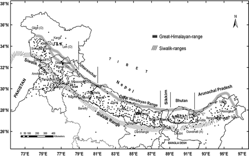
There were practically no rainfall stations in the Nepal Himalayas (Dhar and Mandal Citation1982b, Chalise et al. Citation1996, Chalise and Khanal Citation2001), Bhutan (Quadir et al. Citation2004), or even in Sikkim, prior to 1947. Before 1950, there were very few rainfall recording stations and most of them were in regions under Indian control. At present there are 822 raingauge stations () in the entire Himalayan region whose data are available for varying periods.
Fig. 3 Map of the Himalayan region showing different sections and present network of rainfall stations.
The highest or extreme one-day rainfall data of each of these 822 stations have been collected for those periods for which data are available, from the following sources:
| a. | various publications of the India Meteorological Department (IMD), viz. monthly reports, seasonal and annual reports, daily rainfall summaries, weekly rainfall reports, etc., and data from the National Climate Data Centre (NCDC), IMD, Pune; | ||||
| b. | rainfall records from project authorities, such as the National Thermal Power Corporation (NTPC), National Hydro-electric Power Corporation (NHPC), Central Water Commission (CWC), New Delhi, working in the Himalayas for construction of irrigation systems and hydro-electric power projects in different river basins; | ||||
| c. | the forest departments of the Himalayan states (1975–2000); | ||||
| d. | the Nepal Climatological Atlas (1921–1990); and | ||||
| e. | the Bhutan Meteorological Centre (1989–2005) | ||||
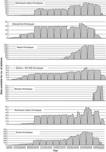
Figure 4 shows the availability of rainfall data years and the number of rainfall stations for different sections of the Himalayas, from west to east, during the period 1861–2007. In extreme northwest India, there are about 50 stations whose data were available up to 2000 only. Also, there are about 73 stations whose data are not continuous (having many gaps) and so it was difficult to select the extreme events from these data. Therefore, the number of stations considered for the last decade, 2001–2007, in this study is considerably smaller.
It should also be mentioned that previously, due to non-availability of special equipment, it was difficult to measure cloudburst rainfall. The prediction of cloudbursts was difficult because rain or snow measuring gauges were installed only after 1947, and mostly below 3000 m altitude. Although specialist equipment is now installed, it is still difficult to forecast such events and the area to be affected due to the unpredictable weather situation in the Himalayas. A recent example of this is the 6–8 August 2010 cloudburst in the Leh region (northwest India), when immense damage was caused to a small town in the Ladakh region of J&K state.
5 METHODOLOGY
Data procured from all the sources listed in Section 4 were first arranged in a uniform format and subjected to quality checking to remove any outliers. These outliers were cross-checked with the synoptic situations of the specific days described in the IMD reports and corrections were carried out wherever required. From this, homogeneous series for 475 rainfall stations were prepared for the period 1871–2007 for use in the present analysis. For some 220 stations, extreme one-day rainfall data are available for more than 50 years (see ). However, stations having less than 10 years of data were not considered in this study.
Fig. 4 Availability of rainfall data over different sections of the Himalayas (1861–2007).
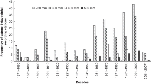
The frequency of occurrence of extreme one-day rainfall for each of the 475 stations was divided into four categories of rainfall magnitude: (i) [250, 300) mm, (ii) [300, 400) mm, (iii) [400, 500) mm, and (iv) ≥ 500 mm, where “[” means “≥” and “)” means “<”. The frequencies of extreme rainfall events recorded in each decade from 1871 to 2007 in these categories are shown in .
Fig. 6 Decadal frequency distribution of extreme 1-day rainfall recording stations in the Himalayan region (excluding Nepal Himalayas).
6 FREQUENCY ANALYSIS OF EXTREME RAINFALL EVENTS
The 475 rainfall stations are mainly located between the Siwalik and the Great Himalayan ranges ( and ). Their altitudinal variation in different sections of the Himalayas is shown by the northwest to northeast transect in .
Fig. 5 Altitudinal variation in the Himalayan region from northwest to northeast.
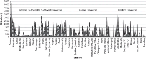
Table 1 Number of stations which recorded one-day extreme rainfall in different sectors of the Himalayas
One-day extreme rainfall (≥250 mm) events occurred in all the months of the year except November. The maximum frequencies of extreme one-day rainfall, 70 to 90, were recorded during the three monsoon months of July, August and September.
Of the 475 stations, 357 have recorded one-day extreme rainfall in excess of 250 mm and 6 stations have recorded one-day extreme rainfall of more than 800 mm (see and ). Their spatial distribution shows that they are mostly clustered in the Sikkim-Sub-Himalayan West Bengal section; the Northeast Himalayas and Garhwal-Kumaun (viz. Uttaranchal) Himalayas (, ). In the Nepal Himalayas, most stations (48) recorded one-day extreme rainfall in the range of 250–400 mm and three stations recorded >400 mm of one-day rainfall. The rainfall data from Nepal Himalayas did not give the dates of occurrence of extreme events. But, Shrestha (Citation2005) mentioned that, on the basis of 30 years data from 1971 to 2000, extreme events in Nepal showed an increasing trend.
Fig. 7 Isohyetal map of one-day extreme rainfall (mm) over the Himalayan region.
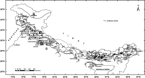
Table 2 Noteworthy rainfall stations in different sectors of the Himalayas which recorded >500 mm of rainfall in one-day (1871–2007)
6.1 Extreme rainfall during El Niño/La Niña and drought/excess rainfall years
During the 137 year period (1871–2007), there were 60 extreme rainfall events that occurred during the 18 drought years (). Of these, all were El Niño years except for 1901, 1968, 1974, 1979, 1985 and 1986. These extremes were mostly associated with the weak to active break monsoon conditions. One-day extremes were not recorded in the drought years of 1873, 1877, 1891, 1899, 1904 and 1915.
Table 3(a) Events of one-day extreme rainfall during drought years
There were 42 one-day extreme rainfall events that occurred during 17 excess rainfall years (). The excess rainfall years during which extreme rainfall occurred were mostly La Niña years or normal years (except for 1994 which was an El Niño year) and mostly were associated with active break monsoon conditions. No stations recorded one-day extreme rainfall during the excess rainfall years of 1884, 1894, 1942 and 1947.
Table 3(b) Events of one-day extreme rainfall during excess-rainfall years
6.2 Frequency and spatial distribution of extreme rainfall events
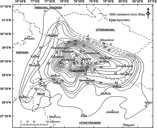
The frequency distribution of extreme one-day rainfall during different decades of the 137-year period (1871 to 2007) () shows that the lowest category of one-day extreme rainfall events (≥ 250 < 300 mm), has the highest frequency in each decade when compared with the other three categories. indicates that the frequencies of one-day extreme rainfall in all the four categories were smaller before 1950. During the 30-year period 1871–1900, when the number of rainfall stations was comparatively very small, the frequency of extreme rainfall events was much less in all the four categories. However, the occurrence of extreme rainfall at certain stations was quite frequent and heavier in magnitude. For example, in a heavy rain spell in September 1880 (Dhar et al. Citation1975), a large number of stations in Uttarakhand district (west Uttar Pradesh Himalayas) recorded one-day extreme rainfall events varying from 500 to 820 mm, although 1880 was an El Niño year. The heavy rain spell of 17–18 September 1880 was associated with the passage of a recurving monsoon depression from the Bay of Bengal. The centre of this rainstorm was at Nagina (Uttaranchal) which recorded 820 mm of rainfall on 18 September 1880 ( and ).
Fig. 8 Two-day isohyetal pattern of the 17–18 September 1880 rainstorm over northwest Uttar Pradesh.
Examples of such events in the rainfall history of this country are numerous. Walker's Rainfall Memoirs (Citation1913) state that 88 stations over the Indian region recorded extreme rainfall ≥ 250 mm (i.e. ≥10 inches) during the period 1827–1890. This shows that in that period, although the number of rainfall stations was smaller, the frequency of one-day extreme rainfall events at each station was quite high.
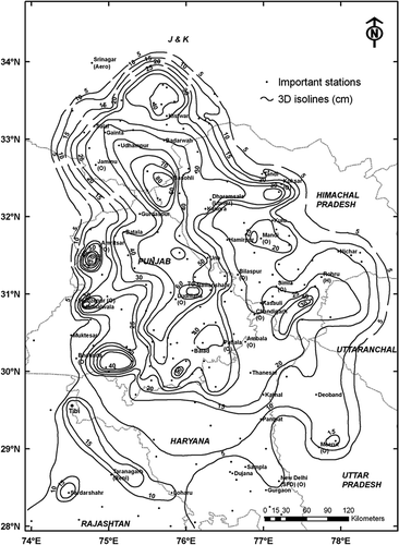
More recently, 24–26 September 1988, another very severe rainstorm occurred in the extreme northwest section of the Himalayas (), i.e. over Punjab and neighbouring Himalayas (Dhar and Nandargi Citation1991). This heavy rain was associated with the movement of westerly waves in the extreme north which synchronized with the passage of monsoon disturbances at lower latitudes causing severe floods in the Ravi, the Beas, the Chenab and the Sutlej rivers.
Fig. 9 Three-day isohyetal pattern of the 24–26 September 1988 rainstorm over the Punjab Himalayas and neighbouring regions.
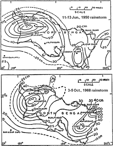
The most noteworthy heavy rain spells experienced over the sub-Himalayan West Bengal-Sikkim section are 11–13 June 1950 and 3–5 October 1968 () (Abbi et al. Citation1970), and over the Bhutan section of the Himalayas, 1–3 August 2000.
Fig. 10 Three-day isohyetal (cm) map of 1950 and 1968 rainstorm over northern region of sub-Himalayan West Bengal (Abbi et al., Citation1970).
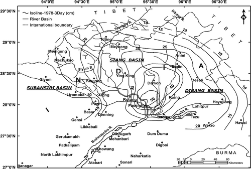
Similarly, in the extreme northeast section of the Himalayas, two very severe rainstorms, 24–26 June 1931 and 21–23 June 1978 ( and ) have occurred causing severe floods in the Brahmaputra River and its tributaries.
Fig. 11 Three-day Isohyetal pattern of the 24–26 June 1931 rainstorm over the Arunachal Pradesh Himalayas.
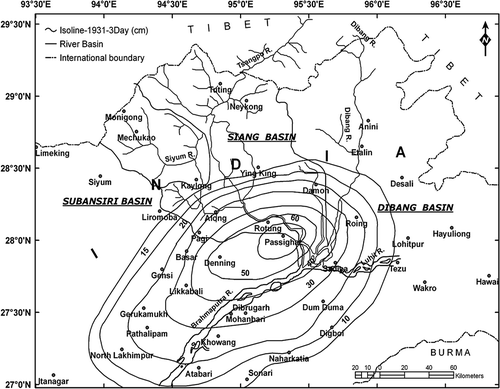
Fig. 12 Three-day isohyetal (cm) pattern of the 21–23 June 1978 rainstorm over the Arunachal Pradesh Himalayas.
There have been variations in the frequencies of different categories from 1951 onwards, which may be due to the increase in the number of raingauge stations and vagaries in rainfall during different years. This is perhaps due to a decrease in movement of active monsoon disturbances over the Indian region after 1951 (Nandargi and Dhar Citation2006).
Across the entire Himalayan region, 32 stations recorded more than 500 mm of rainfall in one-day (see ) during the period of 1871–2007. The spatial distribution of these stations shows that they are mostly concentrated in the western and eastern Himalayas (). Only three stations have recorded >400 mm of rainfall in the Nepal Himalayas. In the western Himalayas, Nagina, Dhampur, Khadrala, Najibabad, Kilba and Jogindarnagar stations and in the eastern Himalayas, Passighat, Zero, Goalpara, Ananda and Surey (Bhutan) stations recorded more than 600 mm of extreme rainfall in one-day. It is also seen from that stations at higher elevations have recorded less extreme one-day rainfall when compared to stations located at lower elevations (i.e. <1500 m).
The spatial distribution of one-day extreme rainfall over different sections of the Himalayas () shows that most of the stations near the Great Himalayan Range, have recorded extreme one-day rainfall in the range of 100 to 200 mm. In the Lesser Himalayan range, heavy rainfalls have occurred mostly in the western and eastern sections. However, heavy rainfall pockets (500–800 mm) were also recorded in one-day. The plain areas of the Siwalik range show that one-day extreme rainfalls recorded in the range of 200–800 mm were mostly associated with rainstorms caused by monsoon disturbances. There are some pockets of low rainfall (<200 mm) indicating that stations located to the lee side of the Himalayan range recorded less rainfall than stations on the windward side.
CONCLUDING REMARKS
The main aim of this study is to demonstrate that in the Himalayas, although the number of rainfall stations in earlier years was less than now, there were more records of extreme rainfall of very high intensity observed than in recent period.
From analysis of the one-day extreme rainfall of 475 stations in the Himalayan region during the period 1871–2007, the following broad conclusions can be drawn:
| 1. | Over the entire Himalayan region, one-day extreme rainfall stations are mostly located between the Siwalik and the Great Himalayan ranges. Stations at higher elevations have recorded fewer extreme one-day rainfalls of 100–200 mm, whereas low level stations with altitudes <1500 m have recorded more one-day extreme rainfall in the range 700 to 900 mm. | ||||
| 2. | One-day extreme rainfall events have been recorded in both years of rainfall excess as well as in drought years. These extreme events have also occurred in the El Niño years. | ||||
| 3. | There are five decades from 1951–1960 to 1991–2000 which show prominent peaks of extreme one-day rainfall frequency events of almost similar magnitude, suggesting some sort of see-saw activity (). This may partly be due to increase in the network of rainfall stations and partly due to the wet and dry years experienced during these decades. Decrease in the frequency of active monsoon disturbances also leads to decrease in extreme rainfall events (Nandargi and Dhar Citation2006). | ||||
To summarize, it may be said that there is an increase in the frequencies of extreme rainfall events from the 1951–1960 decade onwards. Incidentally, during the two decades of 1951–1960 and 1991–2000, the Indian region experienced good monsoon rainfall (Guhathakurta and Rajeevan Citation2007). However, there was a sudden decrease in the frequency of extreme rainfall events in all the four categories in the recent period of 2001–2007 (although decade ends at 2010, for comparison purposes data were only available for 2001–2007) during which the prevailing monsoon conditions were comparatively weak. Hence, it is somewhat baffling as to whether climate change has any impact on extreme rainfall events in the entire Himalayan region, especially, in the recent years of the period 2001–2007.
Acknowledgements
The authors are thankful to the Director, IITM, Pune, for his keen interest and encouragement for carrying out this study. The authors express their sincere thanks to all the Himalayan Project Authorities, Forest Departments, and India Meteorological Department (IMD) for supplying the relevant rainfall data. Last but not the least, thanks are also due to Dr D. S. Pai, Director, India Meteorological Department, for sharing his lecture notes on “Verification of long range forecast and analysis of deficient rainfall”.
Related Research Data
REFERENCES
- Abbi , S.D.S , Gupta , D.K and Jain , B.C. 1970 . A study of heavy rainstorms over North Bengal . Indian Journal of Meteorology and Geophysics (Mausam) , 21 ( 2 ) : 195 – 210 .
- Chalise , S. R. and Khanal , N. R. 2001 . “ An introduction to climate, hydrology and landslide hazards in the Hindu Kush-Himalayan region ” . In Landslide Hazard Mitigation in the Hindu Kush-Himalayas , Edited by: Tianchi , L. , Chalise , S.R. and Upreti , B.N. 51 – 62 . Kathmandu : International Centre for Integrated Mountain Development (ICIMOD) .
- Chalise , S. R. , Shrestha , M.L. , Thapa , K.B. , Shrestha , B.R. and Bajracharya , B. 1996 . Climatic and hydrological atlas of Nepal , Kathmandu, Nepal : International Centre for Integrated Mountain Development (ICIMOD) .
- Dhar , O. N. and Bhattacharya , B.K. 1976 . Variation of rainfall with elevation in the Himalayas—a pilot study . Indian Journal of Power and River Valley Development , 26 ( 6 ) : 179 – 186 .
- Dhar , O. N. , Kulkarni , A.K. and Sangam , R.B. 1975 . A study of extreme point rainfall over flash flood prone regions of the Himalayan foothills of north India . Hydrological Sciences Bulletin , 20 ( 1 ) : 61 – 67 .
- Dhar , O. N. , Mandal , B.N. and Kulkarni , A.K. 1982a . “ Effect of Pir Panjal Range of Himalayas over monsoon rainfall distribution in Kashmir Valley ” . In Proc. Int. Symp. on Hydrological Aspects of Mountainous Watersheds Vol. 1 , I-51 – I-57 . Roorkee, , India
- Dhar , O. N. and Mandal , B.N. 1982b . “ A pocket of heavy rainfall in the Nepal Himalayas—a brief appraisal ” . In Nepal Himalayas: geo-ecological perspectives , 75 – 81 . Naini Tal, , India : Himalayan Research Group .
- Dhar , O. N. and Mulye , S.S. 1987 . “ A brief appraisal of precipitation climatology of the Ladakh region ” . In Monograph on Western Himalayas: environment, problems and development Edited by: Pangtay and Joshi . 87 – 98 .
- Dhar , O. N. and Nandargi , S. 1991 . A study of exceptionally heavy rainspell of Sept., 1988 over northwest India . Vayu Mandal , 21 ( 1-2 ) : 36 – 44 .
- Dhar , O. N. and Nandargi , S. 1993 . Spatial distribution of severe rainstorms over India and their associated areal raindepths . Mausam , 44 ( 4 ) : 373 – 380 .
- Dhar , O. N. and Nandargi , S. 1998 . Rainfall magnitudes that have not been exceeded in India . Weather , 53 ( 5 ) : 145 – 151 .
- Dhar , O. N. and Nandargi , S. 2005a . Distribution of precipitation over the Himalayas . Journal of Meteorology , 30 ( 297 ) : 83 – 91 .
- Dhar , O. N. and Nandargi , S. 2005b . Areas of heavy precipitation in the Nepalese Himalayas . Weather , 60 ( 12 ) : 354 – 356 .
- Dhar , O. N. and Rakhecha , P.R. 1981 . “ The effect of elevation on monsoon rainfall distribution in the Central Himalayas ” . In Proc. International Symp. on Monsoon Dynamics , 253 – 260 . Cambridge : Cambridge Univ. Press .
- Dhar , O. N. , Soman , M.K. and Mulye , S.S. 1984 . Rainfall over the southern slopes of the Himalayas and the adjoining plains during “break in the monsoon” . Journal of Climatology , 4 ( 6 ) : 671 – 676 .
- Gadgil , S. 2003 . The Indian monsoon and its variability . Annual Review Earth and Planetary Sciences , 31 : 429 – 467 .
- Goswami , B. N. , Venugopal , V. , Sengupta , D. , Madhusoodanan , M.S. and Prince , K. 2007 . Increasing trend of extreme rain events over India in a warming environment . Science , X314 : 1442 – 1444 .
- Guhathakurta , P. and Rajeevan , M. 2007 . Trends in the rainfall pattern over India . International Journal of Climatology , 28 : 1453 – 1469 .
- IPCC (Intergovernmental Panel on Climate Change) . 2001 . “ Climate change 2001: Impacts, adaptation and vulnerability ” . In Contribution of Working Group II to the Third Assessment Report of the Intergovernmental Panel on Climate Change , Edited by: McCarthy , J.J. , Canziani , O.F. , Leary , N.A. , Dokken , D.J. and White , K.S. Cambridge : Cambridge University Press .
- IPCC (Intergovernmental Panel on Climate Change) . 2007 . “ Climate change 2007: The physical science basis ” . In Contribution of the Working Group II to the Fourth Assessment Report of the Intergovernmental Panel on Climate Change , Edited by: Parry , M.L. , Canziani , O.F. , Palutikof , J.P. , Hanson , C.E. and van der Linden , P.J. Cambridge : Cambridge University Press .
- Joshi , U. R. and Rajeevan , M. Trends in precipitation extremes over India . Pune: IMD Publications, National Climate Centre Research Report no. 3 . 2006 . 27
- Mani , A. 1981 . “ The climate of the Himalayas ” . In The Himalayas—Aspects of Change , Edited by: Lall , J.S. and Moddie , A.D. Oxford : Oxford University Press .
- Nandargi , S. S. and Dhar , O.N. 2006 . Tropical disturbances and Indian monsoon rainfall . Journal of Applied Hydrology , 19 ( 3 ) : 1 – 7 . Special issue
- Quadir , D. A. , Hussain , A. , Ahasan , M.N. , Chhophel , K. and Sonam , K . 2004 . Climatic characteristic of temperature and precipitation of Bhutan . Mausam , 58 ( 1 ) : 9 – 16 .
- Shrestha , A. B. , Wake , C. P. , Dibb , J. E. and Mayewski , P. A. 2000 . Precipitation fluctuations in the Nepal Himalaya and its vicinity and relationship with some large-scale climatology parameters . International Journal of Climatology , 20 : 317 – 327 .
- Shrestha , K. L. 2005 . Global change impact assessment for Himalayan Mountain regions for environmental management and sustainable development . Global Environmental Research , 96 ( 1 ) : 69 – 81 .
- Sikka , D. R. 1999 . “ Influence of Himalayas and snow cover on the weather and climate of India—a review ” . In The Himalayan Environment , Edited by: Dash . Delhi : New Age International (P) Ltd .
- Walker , G. 1913 . Data of heavy rainfall over short periods in India . Memoirs of the India Meteorology Department , 22 ( 3 ) : 1 – 10 .
- Wang , B , Webster , P.J. and Teng , H. 2005 . Antecedents and self-induction of active-break south Asian monsoon unraveled by satellites . Geophysical Research Letters , 32 : L04704 doi: doi:10.1029/2004GL020996