Abstract
The increasing water demand is a concern affecting many regions in the Mediterranean Basin. To overcome this situation rim countries resorted during the last decades to a massive mobilization of their water resources, often resulting in excessive water exploitation. In such a context, understanding the effects of present recharge and aquifer salinization is crucial for correct water management. Understanding the present hydrogeological situation of coastal plains requires the knowledge of both their past morphologic conditions and their recent geological evolution. Within this framework, this paper presents a review of water related problems in the Mediterranean Basin. It suggests a conceptual model for groundwater resources in Mediterranean coastal plains, deriving from the present and past recharge processes. Special attention is paid to providing a better understanding of climate change impacts on water quantity and quality, and conservation of ecological diversity.
Citation Re, V. & Zuppi, G. M. (2011) Influence of precipitation and deep saline groundwater on the hydrological systems of Mediterranean coastal plains: a general overview. Hydrol. Sci. J. 56(6), 966–980.
Résumé
La demande croissante en eau est un problème qui intéresse de nombreuses régions dans le bassin méditerranéen. Pour remédier à cette situation, les pays riverains ont fait appel à une mobilisation massive des ressources en eau, ce qui a souvent entraîné sa surexploitation. Dans cette situation, la compréhension de la recharge actuelle et de la salinisation des aquifères est cruciale pour une gestion correcte des ressources. Comprendre la situation hydrogéologique actuelle des plaines côtières nécessite la connaissance de leurs conditions morphologiques anciennes et de leurs évolutions géologiques récentes. Dans ce cadre, cette note présente une revue des problèmes liés à l'eau dans le bassin méditerranéen. Il est proposé un modèle conceptuel pour les eaux souterraines dans les plaines côtières de la Méditerranée, modèle s'appuyant sur les processus actuels et anciens de recharge de ces aquifères. Une attention particulière est accordée à une meilleure compréhension des impacts du changement climatique sur la quantité, la qualité des eaux, et la préservation de la diversité écologique.
INTRODUCTION
The hydrogeological and hydrochemical conditions of several coastal and inland aquifers around the Mediterranean Sea have been studied in the last decennia for the critical role played by their water resources (Bortolami et al. Citation1973, Manzano et al. Citation2001, Fleury et al. Citation2007, Grassi et al. Citation2007, Giménez-Forcada et al. Citation2009, Custodio Citation2010). These plains often enclose, in their subsurface, a water record of previous geological periods. The underground resources are invaluable, due to the high quantity and quality of water available. These reservoirs, accessible with certain ease, have been exploited for potable, agricultural, industrial, arts and crafts uses for centuries. However, the exploitation of water resources has increased over recent years, as a consequence of technological, industrial and agricultural development, as well as population growth and the associated water demand (Custodio and Gurgui Citation1989, IWMI Citation2000, Shah et al. Citation2000, Belloumi and Matoussi Citation2002, UNESCO-ISARM Citation2004). Moreover, in recent decades, human activities have seriously affected the fragile balance between the input and output in the water system of these coastal plains; signs of these imbalances include, among the others, lowering of aquifer levels in the piedmont belt by the depressurization of the confined systems (Wright and Burgess Citation1992). Increasing stress on the water balance requires correct management of local irregular resources and development of the traditional, prudent management together with the prohibition of more intensive water resources exploitation (Cudennec et al. Citation2007).
In fact, the balance between water resources and needs is not achieved, and numerous negative effects have emerged (Custodio Citation2002, Cudenec et al. Citation2007, Edmunds Citation2009). Moreover, the regional climate change (Christensen et al. Citation2007) may have major hydrological impacts, which need to be assessed, and decisions need to be made as to which water management should be adopted (Kundzewicz et al. Citation2008, Kundzewicz and Döll Citation2009).
In addition, natural events have reinforced the trend towards the consumption of underground waters. Indeed, a worrying decrease in precipitation and increase in average annual temperatures have been documented (Rozanski et al. Citation1992, Wright and Burgess Citation1992, Issar Citation2003). The consequences include smaller effective meteoric contribution, lower discharge of the rivers and higher evapotranspiration (Koutsoyiannis et al. Citation2010). Furthermore, a general deterioration of water quality in aquifers due to freshwater salinization has been observed. The hydrogeological and hydrochemical information suggests that the sources of salinization are generally related to excessive aquifer exploitation (Edmunds Citation2009). The degree of deterioration, in terms of the decline in piezometric head and the contamination of groundwater by salt, varies depending on location and geological configuration. Salinization of coastal aquifers is a global phenomenon that endangers present and future utilization of groundwater resources (MacDonald et al. Citation2009, Koutsoyiannis et al. Citation2010), particularly in the southern part of the Mediterranean Basin.
Over the last few years, studies and surveys have been carried out in order to determine and to quantify the possible causes of the changes in hydrological balance and of groundwater quality decline. Understanding the effects of present recharge and salinization of aquifers is therefore crucial for water management in these plains, and has to be considered also in regions where groundwater is apparently abundant and where climatic conditions are favourable.
Most of the Mediterranean region is characterized by semi-arid climate and most countries suffer regular water shortages aggravated by recurrent droughts with different degrees of frequency, intensity and severity. This fragile situation renders freshwater scarcer and more unequally distributed. Climate change, the growing demand for water in agricultural and urban development, as well as the expanding tourism industry, have further aggravated the water stress on the region. The northern coastal area of the Mediterranean Basin is relatively well-watered by precipitation and by the river network flowing from the Pyrenean and Alpine chains. In contrast, the southern shore is arid, with a generally poor river system.
The main objective of this study is to suggest a conceptual model of groundwater resources in the Mediterranean coastal plains, deriving from the present and past recharge processes, with a special focus on deep groundwater resources. An attempt has been made to provide a better understanding of water related problems by presenting a wide literature review, where prominence is given to impact of climate changes on water resources quantity and quality, and conservation of ecological diversity in changing climatic conditions. This is a wide-ranging review, dealing with precipitation, groundwater, geology and hydrological systems in the Mediterranean Basin. The paper reflects scientific results obtained within several worldwide or European research efforts, such as the IHP-VI, the COST Action 621, and European Union and Italian projects.
The paper has two major reference periods: the first at the human scale, and the second at the geological scale. The first period deals with the present water-related problems in the Mediterranean Basin, such as climate change impacts, salinization and groundwater exploitation.
PRESENT RECHARGE
The meteorological conditions of the western Mediterranean Basin are affected by the displacement of the Azores anticyclone. Apart from the topography, important forcing factors for the regional variability of precipitation are (Gat and Carmi Citation1970, Araguás-Araguás et al. Citation1996, Araguás-Araguás et al. Citation2000, Gat et al. Citation2003, Froelich et al. Citation2008)) ():
| a. | The low pressure systems originating from the Atlantic Ocean, moving in a south/southeasterly direction; Fig. 1 Schematic representation of the main forcing factors affecting regional variability and precipitation in the Mediterranean Basin. 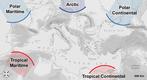 | ||||
| b. | The low pressure systems originating from Maghreb, moving towards the north or northeast; and | ||||
| c. | The cyclonogenesis over the Lion–Genoa Gulfs. | ||||
These factors are due to the movement, be it northward or southward, of the Azores anticyclone modulating rainfall on the Sahara Desert. The temperate regions of the north Mediterranean countries experience warm summer climates with precipitation, essentially originated from continental moisture. In contrast, winter air masses move eastward, favoured by low pressure on the Mediterranean Basin. The European region receives most precipitation during winter from westerly cyclonic disturbances (Koster Citation2005).
Despite the frequent scientific and political debate about greenhouse gas emissions, mainstream science forgets that the most important greenhouse gas is water vapour (Posner Citation2008). It regulates, and regulated in the past, the global climate and the general atmospheric circulation. Changes in the energy balance of the atmosphere control changes in water fluxes: upward (evaporation) or downward (precipitation). At present, as in the past, the main forcing of rainfall is the dynamics of air-mass circulation, which significantly controls the moisture provenance. Thus the definition of the source of humidity is very important for tracing the fingerprint of water resources in the Mediterranean Basin. Stable isotopes of water can be used to label movements and also provide information about cloud condensation temperature, atmospheric vapour source and, hence, the wind direction (IAEA Citation2005).
Air masses crossing the Mediterranean Sea pick up moisture, which modifies and, thus, characterizes the meteoric isotopic signal (Gat and Carmi Citation1970, Araguás-Araguás et al. Citation1996, Citation2000, Gat et al. Citation2003, Froelich et al. Citation2008). If the position of the source changes (e.g. Azores anticyclone more in the south or north), the isotopic composition of water vapour will consequently change. However, while an understanding of the isotopic composition is sufficient for basic studies, it is insufficient when carrying out climate or underground resources exploitation studies, where not only high accuracy but also a better knowledge of the physics of isotopes is necessary. The isotopic signal of precipitation associated with the displacement of the Intertropical Convergence Zone (ITCZ) and the Azores anticyclone represents an excellent methodology for accurate reconstruction of present-day atmospheric circulations and climatic changes experienced in Mediterranean regions (Zuppi Citation2002).
Isotopic data, obtained at the scale of rain events collected during recent decades over peri-Mediterranean countries allow one to define the origin of air masses, and depict their movement at the continental scale (Dray et al. Citation1998, Celle et al. Citation2004, Longinelli et al. Citation2006). The difference in isotopic signals associated with the Azores anticyclone displacement is confirmed by deuterium excess and large seasonal variation in altitude gradients (IAEA Citation2005). Three main areas of water vapour sources are the: Subtropical Atlantic, North Atlantic and Afro-Mediterranean, depending on the Azores cyclone displacement.
In the eastern Mediterranean basin, the stable isotope content of precipitation depicts a more complex situation. In fact, observed spatial and temporal variations of the stable isotope content appear to be strongly related to distinct types of air mass pathways. These include: polar air masses from northeast Europe; Atlantic maritime air masses from southwest Europe; tropical air masses from the northern African continent; westward or northwestward extensions of the Asiatic monsoon, although with a minor contribution; and continental air masses from the east ().
The natural decrease of temperature with increasing elevation seen in mountainous regions usually leads to enhanced condensation and to progressive depletion in the heavy isotopes of precipitation with altitude. Values of this effect usually vary in the Mediterranean Basin between –0.1‰ and –0.6‰ per 100 m (Rozanski et al. Citation1992, Froelich et al. Citation2008).
PAST RECHARGE
The groundwater system is a natural archive of long-term climate change, because of the influence of climate on recharge and the natural flow of groundwater from recharge to discharge areas. The present recharge of the peri-Mediterranean aquifers is very small and only occurs at shallow levels and in areas where the aquifers become unconfined. Direct recharge through the aquifer outcrop or via the overlying soil has been calculated by some authors (Edmunds & Wright Citation1979, Mart & Ben Gai Citation1982, Lorusso et al. Citation2003), and varies between 150 and 3 mm year‐1. Generally, variations in aquifer recharge not only change the aquifer yield or discharge, but also modify the groundwater flow systems.
Using regional transmissivity and storativity data, the rate of re-equilibration to a change in recharge is likely to be less than a thousand years (Wright Citation1985, Wright and Burgess Citation1992).
After archaeological reconstructions, the natural withdrawal of aquifers during the Quaternary era could be evaluated as varying between a few centimetres and several metres (Issar Citation2003). The resolution and application of multiple environmental proxy studies, combined with a greater application of independent dating control, allows a greater number of climatic shifts to be recognized (Issar Citation2003). Like all palaeoclimatic proxies, stable isotope composition of water is affected by more than one factor; therefore, its palaeoclimatic interpretation always contains some degree of ambiguity. Stable isotopes have some advantages over other palaeoclimatic proxies, because the factors affecting stable isotope ratios are relatively few and well known. Thus, the climate-induced variations in the stable isotope content of precipitation will be reflected in the isotopic composition of groundwater (Darling Citation2004). In fact, a change in the stable isotope composition of groundwater marking the transition from the Late Glacial to Holocene has been identified in many aquifers containing waters of different ages. Precipitation during the glacial periods is systematically depleted in heavy isotopes, as compared to modern precipitation, and has a deuterium excess lower than 10‰ (Gat and Carmi Citation1970, Edmunds and Wright Citation1979, Dray et al. Citation1998, Gaye Citation2001, Issar Citation2003). The depleted isotopic contents indicate lower temperatures during recharge processes. Lower temperature induces a variation of humidity and, thus, produces an increase in the amount of precipitation. In other words, a loop system could be considered for the past, as well for the present: a variation of air saturation induced a small reduction of temperature, producing an increase in atmospheric humidity. This implies a large availability of water, leading to the most developed river network of the past (Issar Citation2003).
All isotope data, together with available hydrogeological data should be integrated into one conceptual model of water flow and mass transport in the area, in order to also define how the global climate change may have an impact on the system.
The great influence of deep brines is observed in all the coastal plain of the Mediterranean basin. Overall, the above-mentioned considerations allow us to assume that, in the past, the massifs around Mediterranean basin might have controlled the movement of deep saline water, due to the upward transfer induced by the pressure of shallower aquifers. Thus, the hydrodynamic balance is controlled by shallow freshwater recharged in the surrounding massifs which are characterized by fractured rocks.
DEEP GROUNDWATER RESOURCES
Climate change will pose a major water management challenge in the Mediterranean Basin, increasing water stress, mainly in coastal areas. In Mediterranean countries, fractured aquifers, or karst, are among the most interesting potential resources, easily exploited in regions where mountain chains are located near the coast. For this reason, they are the primary resources withdrawn for urban, industrial and rural uses to avoid the problem of water salinization (Custodio and Gurgui Citation1989, IWMI Citation2000, Pinault et al. Citation2004, UNESCO-ISARM Citation2004, COST Citation2005).
Aquifers in lowland and coastal plains are the most important available source of renewable freshwater. Therefore, mainly in arid and semi-arid regions, abstraction rates greatly exceed natural replenishment rates, leading to over-exploitation (Hashash and Aranyossy Citation1995, Vandenschrick et al. Citation2002, Bakalowicz et al. Citation2003, Bakalowicz Citation2006, Bouchaou et al. Citation2008, Kouzana et al. Citation2009). As a result, the dynamic balance between shallow freshwater and saline water has been disturbed, causing additional saline water encroachment. Salinization processes are usually due to seawater intrusion and deep saline water upwelling, i.e. the flow of dense saline water inland during heavy withdrawals of freshwater from coastal aquifers, or the mobilization of saline formation waters by over-exploitation of inland aquifer systems (Grassi et al. Citation2007, Giménez-Forcada et al. Citation2009). The alluvial coastal aquifers are drained by a large number of wells drilled for civil, industrial, domestic and irrigation purposes. Groundwater pumping, exceeding the recharge, causes severe seawater intrusion or brine uprising. The origin of salinity in this case is in the geological past. Groundwater is a diluting agent; therefore, an inverse relationship between the discharge rate and salinity is generally observed. A similar relationship can be seen where the salinity is transported by geological formations through the dissolution of evaporites or through other water-rock interactions: increased flushing then results in lower water salinity (Gat and Naor Tahal Citation1979). More complicated relationships occur when the salinity is incorporated in a saltwater–freshwater boundary zone (Mazor and Molcho Citation1972), possibly as a result of brine pockets left behind by a receding sea (Warren Citation2006).
The extent and importance of salinization as a global threat have been greatly underestimated (Williams Citation1999). Therefore, it is fundamental to recognize its relevance, and to draw attention to its importance at global and local levels, in order to perform effective management of freshwaters in coastal plains in the Mediterranean basin.
Palaeogeography of coastal plains and their hydrogeological characteristics
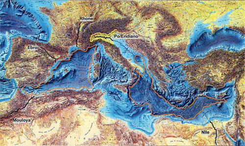
Understanding the present coastal plains means understanding their past morphological conditions and evaluating their recent geological evolution. The Messinian sea level, which was up to 1500 m lower than present level, induced the formation of deep canyons, and, at the same time, allowed the development of deeply fractured media (Loget et al. Citation2005). The new sub-aerial morphology extended the pre-existing drainage network by regressive erosion all around the Mediterranean region (). In the Nile, Rhone, Danube, Dniepr valleys, fluvial incision has propagated at least 300 km towards inland areas, with the depth of incision reaching more than 1000 m. Fluvial incision is limited for smaller rivers (Barber Citation1981, Clauzon Citation1982, Clauzon et al. Citation1987, Citation2005, Krijgsman et al. Citation1999, Schoorl and Veldkamp, Citation2003, Marsaglia et al. Citation2004).
Fig. 2 Mediterranean Basin after Messinian sea-level drop. The orange areas represent the limit of the sea after the water regression.
Messinian incisions were later preserved as a consequence of the rapid sea-level rise and the resulting detrital sedimentation during the Early Pliocene (Chumakov Citation1973, Krijgsman et al. Citation1999). Successively, these overfilled Messinian valleys were re-incised during glacial times when the sea level decreased by 140 m, and nowadays by the current drainage networks.
During the Late Messinian and the Early Pliocene, the combination of late tectonic events and relative sea-level changes caused phases of immersion/erosion (canyons, slump scars) and transgression/regression of fluvio-deltaic systems, with deposition of high-energy conglomerations and sands (Clauzon et al. Citation1987, Citation2005, Mattavelli and Novelli Citation1988, Loget et al. Citation2005).
The Messinian erosion surface is overlain by a marine succession and is essentially comprised of clay and blue silts (Marine Pliocene or Piacenzian clays) with lateral and vertical facies variations (Marine Pliocene sand). Hydraulic conductivity of the silty-clay sequence is about 10‐8 to 10‐10 m s‐1 and, therefore, can be considered as an aquitard.
In the Pliocene, the regression–transgression cycles were ended by a long and extended transgression of the sea. The Mediterranean Basin was flooded following the opening of the Strait of Gibraltar (Clauzon et al. Citation1987, Citation2005, Loget et al. Citation2005).
The Pliocene-Quaternary deposits result from the interaction among sea-level changes, tectonics and physiographic configuration. During the Early Pliocene, a generalized synsedimentary transgression with extensive tectonic activity resulted in a homogeneous sedimentation, locally deformed by extensional tectonic activity (Estrada et al. Citation1997). The sediment distribution was controlled by the pre-existing palaeotopography (large rivers: Ebro, Rhone, Nile). During the Late Pliocene, a generalized synsedimentary regression took place.
The levels of the continental deposits (Continental Pliocene or Astian sands) consist of a sand layer with some lignite, clay and inter-bedded lacustrine limestone. The thickness is estimated to range between 100 and 300 m (Clauzon et al. Citation1987).
The Continental Pliocene aquifer is characterized by a hydraulic conductivity of about 10‐3 to 10‐4 m s‐1, about five orders of magnitude higher than that of the basal clays. Transmissivity values are between 10‐2 and 10‐3 m2 s‐1 (IGME Citation2003, Morell Citation2003) and the porosity ranges between 0.1 and 1 × 10‐5 with a storage coefficient value of about 10‐2 and a transmissivity of 10‐2 to 10‐5 m2 s‐1. (Chabart Citation1996, IGME Citation2003, Morell Citation2003, Pilla et al. Citation2005). Therefore, in the central sectors of the coastal plains, the Pliocene aquifer is always confined or semi-confined and the values of these coefficients are clearly lower.
The Pliocene–Quaternary sequences are dominantly detrital, as suggested by the interpretation of data derived from several multichannel seismic profiles (Bellaiche and Mart Citation1995). During the Quaternary, the high-frequency sea-level fluctuations are connected to the glacial–interglacial oscillations of the Pleistocene. These climatic fluctuations were greater in magnitude than those occurring in the Tertiary. The oscillatory temperatures were accompanied by regression–transgression cycles in the Mediterranean Sea. For about 80% of the past two million years, glacial conditions prevailed (Willis and Whittaker Citation2000), followed by fluvial environments during the interglacial periods.
The Quaternary alluvial deposits are subdivided into two categories: (i) old and recent banks or terraces with gravel and variably eroded pebbles, and (ii) Holocene layers corresponding to the maximum transgression of the Flandrian sea-level rise (Svitoch et al. Citation2000, Issar Citation2003). The Quaternary alluvial aquifer lies along the main rivers and the Mediterranean coastline. Its thickness is varied. The porosity of the Quaternary alluvial aquifers is between 0.1 and 1 × 10‐5. The transmissivity values differ according to the sectors, varying from 10‐2 to 10‐5 m2 s‐1 (IGME Citation2003, Morell Citation2003, Pilla et al. Citation2005).
Plio-Quaternary sediments cover the fractured aquifers of pre-Messinian basement. They enclose confined aquifers, whose outlets at the surface are, in general, artesian water points. Similar conditions increase groundwater residence time to as much as several thousand years, whereas it is commonly less than 5 years in fractured aquifers. These conditions control, in the saturated zone, dynamic storage and favour the discharge of fresh groundwater at depth both by conduit and diffuse processes (Hobbs and Smart Citation1986). Those processes originate both a movement toward more recent aquifers and Submarine Groundwater Discharge (SGD) under a seawater column generally not below –50 m.
Under sedimentary cover, the transfer toward upper layers is essentially a pressure transfer controlled by the potentiometric surface of shallow aquifers, whereas on the sea floor freshwater transfer also includes a mass transfer. In the first case, salts are removed, as salty water from brines is trapped in the depth (Conti et al. Citation2000), and is hydraulically stagnant (Mazor and Nativ Citation1992, Mazor Citation1995); in the second case, the high rate of coastal aquifer exploitation leads to saline water encroachment. The seawater intrusion rate therefore depends on how much groundwater flow is available to be discharged into the sea (Custodio and Bruggeman 1982, Tulipano. Citation2004, COST Citation2005, Sanz Escudé Citation2007, Custodio Citation2010).
Dual circulation
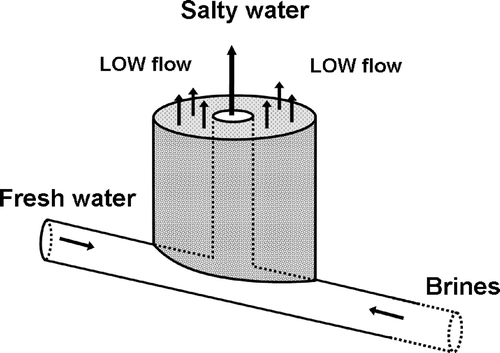
The problem of flow through a fractured environment toward porous media is primarily a problem of flow through a unique dual-porosity system (Sanz Escudé Citation2007) (). This includes the fracture network and hydrogeological basement seen in mountain areas, and the porous matrix in the piedmont plain. These two components are hydraulically interconnected and cannot be treated separately. The degree of interconnection between the two flow systems defines, at a regional scale, the characteristics of the entire flow domain, and is a function of the hydraulic properties of each of them. These properties include fracture-network distribution, orientation, apertures, connectivity, sediment porosity and hydraulic conductivities of the entire system. The regional hydraulic continuity controls an upward transfer of either mass or pressure in the porous media. In the case of mass transfer, deep-water mixes, at a different rate, with shallow water (Pilla et al. Citation2005). Upward pressure transfer acts as a piston, forming the real basement of the plain's aquifers. The higher-pressure heads of the deep aquifer maintain, at a rather constant level, the water table, even in the case of a significant withdrawal rate (Bakalowicz et al. Citation2003, Custodio Citation2010). Thus, the mixed water flowing upward divides in two pathways: a fast turbulent flow through well-developed fractured systems, and a slow flow through porous areas (Sanz Escudé Citation2007).
Fig. 3 Schematic representation of flow through a dual-porosity system. Mixed water flow: fast turbulent flow through well-developed fractured systems, and slow flow through porous areas.
In the piedmont areas, it is commonly assumed that groundwater in porous media aquifers makes up the majority of streamflow during periods of baseflow (Freeze and Cherry Citation1979). Conversely, during high flow, the stream recharges the aquifer. However, this concept is defined only for streams underlain by porous media, not by fractured rock. When fractured rock constitutes, at a regional scale, the principal aquifer, the nature of the exchange in the piedmont zone, between porous and fractured aquifers, and between surface water and subterranean waters, can become very complex. To assist in quantifying the interaction between groundwater flow systems and the stream environment, field investigations were often conducted (Mazor and Nativ Citation1992, El Yaouti et al. Citation2008, Mencio and Mas Pla Citation2008). Frequently in the Mediterranean Basin piedmont areas, as freshwater penetrates to depth through the fractured medium, brines can be mobilized and rise towards the surface as diffuse seepage zones in the porous media, or as a continuous seepage face.
Submarine groundwater discharge (SGD)
When the sea level falls, continental groundwater and surface runoff tend to adapt to the new base level, and water fluxes are deeply modified (Faure et al. Citation2002, Faure and Faure Citation2004). The fall in sea level is accompanied by a retreat of the shoreline and, consequently, by a change in the location of existing springs; in addition, it leads to the location of new springs along the shoreline ().
Fig. 4 Schematic depiction (not to scale) of processes associated with SGD. Reprinted by permission from Macmillan Publishers Ltd: Nature, Thibodeaux and Boyle, copyright Citation1987.
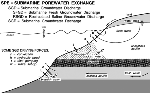
Similarly to the hydraulic exchanges controlled by water head or by direct mass transfer between fractured systems and porous media, fluxes below sea level and submarine springs must be considered. Due to the sea-level variation during the Quaternary and the Tertiary, part of these aquifers may presently discharge directly into the sea at depth. Submarine springs are known off shore mainly in karst areas (Kohout Citation1966, Bakalowicz Citation2005, Surić et al. Citation2005). They are temporary or permanent, and their discharge rates and electrical conductivities vary as a function of time (Pinault et al. Citation2004, Bakalowicz Citation2006). Flow may range from a few litres per second to several cubic metres per second, according to the literature (Bakalowicz et al. Citation2003, Bakalowicz Citation2005, 2006, Pinault et al. Citation2004, COST Citation2005, Mijatović, Citation2006, Fleury et al. Citation2007, Bokuniewicz et al. Citation2008), and electrical conductivity from a few hundred to about 1000 μS cm‐1. All the unknowns in the continental water balance are commonly assigned to submarine springs, which are often difficult to monitor (Bakalowicz et al. Citation2003, Pinault et al. Citation2004, COST Citation2005, Mijatović Citation2006, Bokuniewicz et al. 2007).
Groundwater recharge
Fluxes indicate a general centripetal movement from the high plateaus to the plains; this is due to several factors, such as: the elevation of the water table in unconfined aquifers, the potentiometric surface of confined aquifers, hydraulic conductivity, porosity, and the dimensions of the aquifers.
Corresponding to lateral flanks, the recharge areas of the main confined aquifers can be found in the mountains. In such cases, the potentiometric lines in the close mountain areas could reach elevations of more than 1000 m a.s.l. Thus, the transfer toward the upper layers of the plains is essentially a pressure transfer controlled by more than 2000 m water head. In other words the surrounding mountain areas must be considered as the “water towers” of the adjacent plains.
The main recharge of plain aquifers takes place preferentially on higher elevations along contact areas between porous media and outcropping fractured media. Recharge can also take place in plain areas at different rates depending upon the hydraulic properties of the unsaturated zone, plant-water use, surface runoff characteristics and rainfall amount. The increase in lateral recharge rates induces a water balance shift in the dual system. The regional hydrogeological system compensates for the additional input of groundwater by increasing the lateral hydraulic gradient towards the area of groundwater discharge. Simultaneously, the transmissivities of the unconfined aquifers increase, thereby extending areas of groundwater discharge. The vertical hydraulic gradients in discharge areas increase with depth and instigate an increase in the amount of groundwater flowing upward from deep confined aquifers. Consequently, a rise in the seepage velocities and discharge rates is provoked.
The aquifers are also directly recharged throughout the plain (i.e. from rivers and rainfall); however, recharge is significantly augmented at higher elevations in the surrounding highlands. This produces a classic groundwater flow system composed of local (shallow), and intermediate and regional (deep) flow systems; however, the boundaries between these systems are not distinct due to natural mixing of young (local recharge) and older (regional recharge) groundwater. Vertical gradient reversal, within each of the piezometer nests, is also consistent with mixing. Isotopes (18O and 2H) in precipitation and groundwater indicate that groundwater at any given depth below the water table comprises a mix of water recharged locally and regionally (higher elevations).
In general, the greater the depth of the aquifer, the higher the source elevation, and the longer the length (distance and time) of the flow path towards the sea. The principal porous water-bearing units in the peri-Mediterranean basin are the Holocene and Continental Pliocene aquifer systems. These two aquifer systems are separated by intermediate confining units, which are composed of clays, silts and sands.
Groundwater salinity
The sea-level rise not only changes the coastline, but also influences the hydrological functions of coastal systems, such as groundwater flow, runoff and water quality (Gornitz et al. Citation1982, Day Citation1992, Sahagian Citation2000, Ayache et al. Citation2009). Its impact is similar to that of reduced flows in surface networks and in aquifers. The sea-level rise increases the saltwater pressure, whereas the exploitation of continental waters reduces the freshwater hydraulic head. This would threaten the viability of freshwater aquifers and other sources of fresh groundwater. In other words, the final result of the combined action of sea-level rise and large aquifer exploitation is the salinization of land and water. The processes responsible for the contamination of land and water by salt are complex and intimately related to the transport of dissolved mass in groundwater flow systems. The redistribution of soluble salts accumulated in a catchment is evident mainly in areas of low vertical elevation, such as terminal salt lakes, dry salinas, and areas of saline seeps (Flowers & Hunt Citation2007).
Whereas the alluvial aquifers are particularly sensitive to the present salt-water intrusion, contamination from the deep aquifers is generally the result of vertical hydraulic connection, due to neo-tectonic activity or lateral sedimentological variation. Although aquifer salinization may be natural, it is often due to human over-exploitation.
The salinity distribution of groundwater in the aquifers of coastal areas around the Mediterranean Sea has a complicated pattern, especially in the upper 50 m of the subsurface. The complexity of the observed pattern is mainly the result of superimposed variations of sea level: present, Quaternary, Messinian. At depths varying between subsurface and 1000 m, groundwater with the salinity of seawater or higher is found. The origin of brackish saline and hypersaline groundwater is linked to the occurrence of salinity inversions near the boundary between Early-Pliocene marine and fluvial strata, and Messinian seawater (Conti et al. Citation2000, Di Sipio et al. Citation2006, Kafri et al. Citation2007).
Water in all deep-drilled wells in the central sectors of peri-Mediterranean coastal plains consistently shows increasing salinity with depth, indicating the ubiquitous presence of a deep saline brine (Issar Citation1968, Wright Citation1985, Wright and Burgess, Citation1992, Crampon et al. Citation1996, Barazzuoli et al. 1996, Taniguchi et al. Citation2003, Edmunds et al. Citation2003, Saad et al. Citation2004, Weinthal et al. Citation2005, Shagar et al. Citation2006, Grassi et al. Citation2007, Trabelsi et al. Citation2009, Edmunds Citation2009, MacDonald et al. Citation2009, Ben Moussa et al. Citation2010). Depth profiles of sulphur, nitrogen and carbon dissolved compounds, as well as changes in earth-alkaline concentration, can be used to characterize processes typically determined by the bacterial processes of decomposition of organic matter. Indeed, biomass accumulated with and inside terrigenous sediments that have evolved to a different degree of maturity (i.e. gas, coal, lignite, peat) control the redox behaviours of aqueous phases in aquifers and aquicludes. Waters from the greatest depths show high pH values (equal to or higher than 8.0), as well as the absence of nitrates and sulphates, likely corresponding to a complete consumption of dissolved CO2 and O2. The concentrations of conservative elements, such as halides, give valuable information about fluid sources and the biogeochemical processes controlling their movement. The study of changes in the chemical composition of deep waters provides a powerful tool for characterizing processes of organic matter degradation, and processes of fluid diffusion and advection in Plio-Pleistocene sediments.
Two main geological models present in the scientific literature could explain the origin of the brines:
| a. | autochthonous for upward diffusion of brines produced by earlier sub-aerial evaporation of seawater, or | ||||
| b. | allocthonous for dissolution of outcropping Messinian evaporites and consequent transport from other locations of solutes derived from evaporite dissolution. | ||||
Brines of Messinian age could have seeped into the underlying sediments and have been trapped under the rapidly accumulating Pliocene–Pleistocene sediments at the end of the Messinian salinity crisis (Hsü et al. Citation1973, Hardie and Lowenstein Citation2004). Furthermore, the possible influence of hydrothermal activity on the pore-fluid compositions cannot completely be ruled out (Bernasconi Citation1999), as volcanic activity is well known in the Mediterranean Basin.
Nevertheless, geochemistry indicates that these waters were essentially of marine origin, and have concentrated to the stage of gypsum precipitation. The mobility of the brines is restricted because of their high density. Natural outflows of brackish waters are observed, especially in relation with tectonic features, such as buried and outcropping thrust faults. Saline waters are brought to the surface either by infiltrating meteoric waters, that can partially leach the upper part of the brines, or by the compressive forces acting along the orographic margins, squeezing the brines out from the sediments.
This broad reconstruction does not take into account local disturbances associated with the intense exploitation of deep groundwater for domestic or industrial purposes, and, sometimes, for methane or oil extraction. Human-induced perturbations are a serious concern in the region, as these have often lowered the pore-water pressure at depth. They are frequently considered to be responsible for the increase in subsidence of the plains and pollution of coastal aquifers by present saline intrusion.
Considering all the presented components, the hydrogeological conceptual model could be as follows: oldest waters (late Messinian) are found in the confined aquifers, where the presence of buried structures hinders natural discharge. In other words, the water is practically stagnant (Mazor Citation1995) and can be mobilized only under strong variation of hydrostatic pressure.
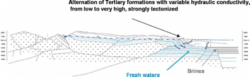
Also Pliocene and Pleistocene confined aquifers show essentially passive hydrodynamic conditions. The pressure heads, which are controlled by pre-Messinian fractured media, maintain a higher piezometric level than the shallower aquifer (). This inhibits the possibility of recent water penetrating far below the surface, but allows the upward pressure transfer of deep groundwater. Porous and fractured media have been essentially recharged by freshwater, which infiltrated at the end of the cold climatic periods when discharge from the northern rivers increased simultaneously with the melting phase of glaciers in the mountains (Alpine systems and Pyrenean). At the same time rivers from the Middle East and Africa discharged larger quantities of water due to the more humid conditions on these continents.
Fig. 5 Schematic hydrogeological cross-sections between fractured aquifer through the tectonic line and porous media in the plain. Hatched area: saturated zone in fractured aquifer; cross: metamorphic basement. Note that the box is out-of-scale and it is intended to highlight the difference in elevation of the groundwater from the karstic to the porous aquifers (after Pilli Citation2006).
Anthropically induced perturbations in deep porous aquifers partially or totally depressurize them, creating convective cells that favour the slow displacement of saline and low-quality (e.g. rich in F, As, Mn, V, Se) groundwater bodies toward the more superficial layers (Custodio Citation2002, EUWI Citation2006). Some of these waters are very old (between early Quaternary and late Messinian ages), and confined in deep-seated aquifers and aquitards. The groundwater head potential around wells changes as a function of the high exploitation rate, thus modifying the way in which waters of different depths or origins mix (Custodio Citation2002). This means that water quality may be progressively changing. In other words, the oldest waters act as a “point source of pollution” through the lithological and granulometric discontinuities of aquicludes and aquitards.
There are several possible mechanisms, some more plausible than others, that can explain the processes and pathways of saltwater movement within the coastal plains aquifer systems (Spechler Citation2001). They are: (a) the movement of unflushed pockets of relict seawater within the aquifer system; (b) landward movement of the freshwater–saltwater interface; (c) regional penetration of saltwater below pumped wells; and (d) the upward leakage of saltwater from deeper, saline water-bearing zones of the aquifer system through semi-confining units or joints, fractures, collapse features, and other structural anomalies (Masterson and Garabedian Citation2007, Mulligan et al. Citation2007). During the Pleistocene, the sea level stood at a much higher level than it does today and the peri-Mediterranean coastal aquifers were invaded with seawater. In some of the southern coastal plains (i.e. Tunisia, Libya and Egypt), this water may not have been completely flushed from the aquifer. Generally, pockets of unflushed relict seawater are found in strata of relatively low permeability. Therefore, geochemical logs of many wells indicate that the more permeable zones are the source of saline water to the well, implying that unflushed relict seawater is a minor source of saline water in the Mediterranean Basin (Vengosh et al. Citation1994, Conti et al. Citation2000, Di Sipio et al. Citation2006, Kafri et al. Citation2007).
This has resulted from natural leakage through the middle semi-confining unit and from cone of depression associated with pumping wells installed near the lower boundary of the Holocene aquifer. As intensive agriculture and industrial activities take place, the area near the coast is, also, significantly developed for the potential exploitation of its groundwater resources.
CONCLUSION
Stable isotope composition of precipitation is a fundamental parameter in monitoring changes in circulation patterns, and it can help in assessing the magnitude of interaction with vapour generated over the Atlantic Ocean or over the Mediterranean Sea. For instance, continental air masses with low humidity are (more) affected when crossing the Mediterranean by the incorporation of water vapour that originated over the sea.
As known from the literature, the use of deuterium excess, in addition to absolute values of oxygen-18 and deuterium in rain water, is useful for tracing of seasonal air mass origin and vapour transport. In fact, the contrast between winter and summer data is very significant; therefore, in the Mediterranean region, high deuterium excess should not be systematically associated with a Mediterranean Sea effect. Major changes in deuterium excess in precipitation samples occur from one day to another. These abrupt changes are attributed in some cases to the large emission of water vapour to the atmosphere, a consequence of anthropogenic activities, and to the rapid variation in the position of the inversion layer.
Groundwater exploitation in the region has increased dramatically during recent decades, mainly due to an increase in industrial activities, in irrigated agriculture, associated with urban and tourism development. Thus, many groundwater resources are at risk of being exhausted through overpumping. With withdrawal exceeding the internally renewable water resources, the resulting groundwater scarcity is, in many cases, accompanied by poor groundwater quality, especially in coastal aquifers, where water is often highly saline, reducing its utility. Aquicludes are not uniform, nor are they impervious rock units, but rather an alternation of permeable and impermeable strata dislocated by numerous fault systems, which facilitate the accessibility of brines into the more superficial aquifers. The mobilization of the saline fluids and their injection toward the surface could be due either to diffusion of saline fluids occurring in the permeable horizons through the clays, or to their upconing following intensive pumping in the coastal plain aquifers. It could have also been caused by up-dip movement of saline water as the result of direct pressure transfer generated by the freshwater head in fractured horizons of neighbouring highlands. Another possible mechanism could be hydraulic contact with pressurized brines flowing vertically along fault zones from deep reservoirs because of neo-tectonic activity. The squeezing of saline interstitial water from the clays by Quaternary seismic activity is of secondary importance in groundwater salinization.
Acknowledgements
Originally, this paper was presented during the side event “Hydrological changes in semi-arid and arid areas under climatic and human influences: focus on the Mediterranean region” within the framework of the Sixth Phase of the International Hydrological Programme (IHP-IV: Theme 3, Land Habitat Hydrology), held in Tunis on 21 June 2006, in addition to the UNESCO International Scientific Conference on “The Future of Drylands”. This work was partly supported by the by the Geochemical Seismic Zonation EC Programme funded under Contract ENV4-CT96-0291, Project leader Prof. Salvatore Lombardi, by MIUR 2005 Grant PRIN “Gli acquiferi profondi della Pianura Padana s.l. come risorse regionali: acquitardi nella idrodinamica, generatrici di acque chimicamente e termicamente anomale, luogo idoneo per l'intrappolamneto della CO2 atmosferica”, by the ELANCAM project (EU grant: AML/19.0902/97/0666(II-0419-FA-FCD-FI) and by a MIUR/Interlink grant (Réseau Interdisciplinaire Méditerranéen).
Our ideas benefited from discussions with many colleagues, among whom we particularly wish to thank Drs Ch. Leduc of IRD, France, Cl. Jusserand, Dr E. Sacchi and Prof. M. Cerasuolo: their critical reviews significantly improved the quality of the manuscript. We also thank Dr T. Lovato for his support with figures. To conclude, the authors would like to apologize to friends and colleagues for any omission of relevant papers in such a wide-ranging review.
Related Research Data
REFERENCES
- Araguás-Araguás , L. 1996 . Global monitoring of the isotopic composition of precipitation . Journal of Radioanalytical and Nuclear Chemistry , 205 ( 2 ) : 189 – 200 .
- Araguás-Araguás , L. , Froehlich , K. and Rozanski , K. 2000 . Deuterium and oxygen-18 isotope composition of precipitation and atmospheric moisture . Hydrological Processes , 14 : 1341 – 1355 .
- Ayache , F. 2009 . Environmental characteristics, landscape history and pressures on three coastal lagoons in the southern Mediterranean Region: Merja Zerga (Morocco), Ghar El Melh (Tunisia) and Lake Manzala (Egypt) . Hydrobiologia , 662 ( 1 ) : 15 – 43 .
- Bakalowicz , M. 2003 . “ Karst development potential and base level changes in Mediterranean regions: a unique reference model ” . In Tecnologìa de la intrusion de agua de mar en acuiferos costeros: paises mediterraneos , Madrid : IGME . ISBN: 84‐7840 470‐478
- Bakalowicz , M. 2005 . Karst groundwater: a challenge for new resources . Hydrogeology Journal , 13 ( 1 ) : 148 – 160 .
- Bakalowicz , M. Importance of regional study site conditions in elaborating concepts and approaches in karst science . Perspectives on karst geomorphology, hydrology, and geochemistry; a tribute volume to Derek C. Ford and William B. White . Vol. 404 , pp. 5 – 22 . Geological Society of America Special Paper .
- Barber , P. M. 1981 . Messinian subaerial erosion of the Proto-Nile delta . Marine Geology , 44 : 253 – 272 .
- Barazzuoli , P. 1999 . Olocenic alluvial aquifer of the River Cornia coastal plain (southern Tuscany, Italy): database design for groundwater management . Environmental Geology , 39 ( 2 ) : 123 – 143 .
- Bellaiche , G. and Mart , Y. 1995 . Morphostructure, growth patterns, and tectonic control of the Rhone and Nile deep-sea fans: a comparison . AAPG Bulletin , 79 ( 2 ) : 259 – 283 .
- Belloumi , M. and Matoussi , M. S. 2002 . Evaluation de la valeur de préservation de la qualité de la Nappe d'Oued Kheirate . New Mediterranean , 1 ( 2 ) : 39 – 45 .
- Ben Moussa , A. 2010 . Investigation of ground water mineralization in the Hammamet–Nabeul unconfined aquifer, north-eastern Tunisia: geochemical and isotopic approach . Environmental Earth Sciences , doi: doi:10.1007/s12665-010-0616‐1
- Bernasconi , S. M. Interstitial water chemistry in the western Mediterranean: Results from LEG 1611 . Proceedings of the Ocean Drilling Program Scientific Results . Edited by: Zahn , R , Comas , M. C. and Klaus , A. Vol. 161 , pp. 423 – 432 .
- Bokuniewicz , H. 2008 . Direct measurements of submarine groundwater discharge, SGD) over a fractured rock aquifer in Flamengo Bay Brazil . Estuarine and Coastal Shelf Science , 76 ( 3 ) : 466 – 472 .
- Bortolami , G. C. , Fontes , J. C. and Panichi , C. 1973 . Les isotopes du milieu et circulation dans les aquifères du sous-sol venitien . Earth and Planetary Science Letters , 19 : 154 – 167 .
- Bouchaou , L. 2008 . Application of multiple isotopic and geochemical tracers for investigation of recharge, salinisation, and residence time of water in the Souss-Massa aquifer, southwest of Morocco . Journal of Hydrology , 352 : 267 – 287 .
- Celle , H. 2004 . Oxygen-18 variations of rainwater during precipitation: application of the Rayleigh model to selected rainfalls in southern France . Journal of Hydrology , 289 : 165 – 177 .
- Chabart , M. 1996 . La recharge de l'aquifère multicouche du Roussillon et les conséquences d'un éventuel changement climatique sur la gestion de la ressource en eau (Pyrénées-Orientales) , 257 Orléans : BRGM, BRGM Document .
- Christensen , J. H. 2007 . “ Regional climate projections. Contribution of Working Group I to the Fourth Assessment Report of the Intergovernmental Panel on Climate Change ” . In Climate change 2007: the physical science basis , Edited by: Solomon , S. 847 – 943 . Cambridge : Cambridge University Press .
- Chumakov , I. S. 1973 . “ Pliocene and Pleistocene deposits of the Nile valley in Nubia and upper Egypt ” . In Initial Reports of the Deep Sea Drilling Project , Edited by: Hsü , K. J. , Cita , M. B. and Ryan , W. B. F. Vol. 13 , 1242 – 1243 . Washington, DC : US Govt Printing Office .
- Clauzon , G. 1982 . Le canyon messinien du Rhône: une preuve dèsicive du “dessicated deep basin model” . Bulletin de la Société géologique de France , 24 : 231 – 246 .
- Clauzon , G. 1987 . Alternate interpretation of the Messinian salinity crisis: controversy resolved? . Geology , 24 ( 4 ) : 363 – 366 .
- Clauzon , G. 2005 . Influence of Mediterranean sea-level changes on the Dacic Basin (eastern Paratethys) during the late Neogene: the Mediterranean Lago Mare facies deciphered . Basin Research , 17 ( 3 ) : 437 – 462 .
- Conti , A. 2000 . Geochemistry of the formation waters in the Po Plain (northern Italy): an overview . Applied Geochemistry , 15 ( 1 ) : 51 – 65 .
- COST (Cooperation in the field of Scientific and Technical Research) . COST Action 621 . Ground water management of coastal karstic aquifers. Final report. EUR 21366 En, 366 . 2005 .
- Crampon , N. , Custodio , E. and Downing , R. A. 1996 . The hydrogeology of Western Europe; a basic framework . Quarterly Journal of Engineering Geology and Hydrogeology , 29 ( 2 ) : 163 – 180 .
- Cudennec , C. , Leduc , C. and Koutsoyiannis , D. 2007 . Dryland hydrology in Mediterranean regions—a review . Hydrological Sciences Journal , 52 ( 6 ) : 1077 – 1087 .
- Custodio , E. 2002 . Aquifer overexploitation: what does it mean? . Hydrogeology Journal , 10 ( 2 ) : 254 – 277 .
- Custodio , E. 2010 . Coastal aquifers of Europe: an overview . Hydrogeology Journal , 18 ( 1 ) : 269 – 280 . doi: doi:10.1007/s10040-009-0496‐1
- Custodio , E. and Bruggeman , K. A. 1987 . Groundwater problems in coastal areas. Paris: UNESCO . Studies Reports in Hydrology , 45 : 15 – 76 .
- Custodio , E. and Gurgui , A. , eds. 1989 . Groundwater Economics. Selected Papers from a UN Symposium held in Barcelona , Spain, Amsterdam : Elsevier .
- Darling , W. G. 2004 . Hydrological factors in the interpretation of stable isotopic proxy data present and past: a European perspective . Quaternary Science Review , 23 : 743 – 770 .
- Day , J. W. Sea level rise, management options and the future of Mediterranean coastal wetlands. In . Proceedings of Conference on managing Mediterranean wetlands and their birds for the year 2000 and beyond . Slimbridge, UK. Edited by: Finlayson , C. M. , Hollis , G. E. and Davis , T. J. pp. 32 – 38 . IWRB Special Publ. 20 .
- Di Sipio , E. , Galgaro , A. and Zuppi , G. M. 2006 . New geophysical knowledge of groundwater systems in complex estuarine environment . Estuarine Coastal and Shelf Science , 66 : 6 – 12 .
- Dray , M. 1998 . “ Air mass circulation and the isotopic “Shadow effect” in precipitation in the French and Italian Alps ” . In Isotope Techniques in the Study of Environmental Change, Proceedings Series , 107 – 117 . Vienna : International Atomic Energy Agency . IAEA-SM-349/10
- Edmunds , W. M. 2009 . Palaeoclimate and groundwater evolution in Africa—implications for adaptation and management . Hydrological Sciences Journal , 54 : 781 – 792 .
- Edmunds , W. M. and Wright , E. P. 1979 . Groundwater recharge and paleoclimate in the Sirte and Kufra basins, Libya . Journal of Hydrology , 40 : 215 – 229 .
- Edmunds , W. M. 2003 . “ Groundwater as an archive of climatic and environmental change: Europe to Africa ” . In Past climate variability through Europe and Africa , Edited by: Battarbee , R. W. , Gasse , F. and Stickley , C. E. Vol. 6 , 279 – 306 . Dordrecht : Developments in Palaeoenvironmental Research Series .
- El Yaouti , F. A. 2008 . Modelling groundwater flow and advective contaminant transport in the Bou-Areg unconfined aquifer (NE Morocco) . Journal of Hydro-Environmental Research , 2 ( 3 ) : 192 – 209 .
- Estrada , E. , Ercilla , G. and Alonso , B. 1997 . Pliocene–Quaternary tectonic-sedimentary evolution of the NE Alboran Sea (SW Mediterranean Sea) . Tectonophysics , 282 : 23 – 442 .
- EUWI (European Water Initiative) . 2006 . “ Mediterranean Groundwater Report ” . In Technical report on groundwater management in the Mediterranean and the water framework directive
- Faure , H. and Faure , O. 2004 . “ Décharge des nappes d'eau souterraines en Méditerranée au Messinien (Groundwater discharge into Mediterranean Sea during Messinian drawdown) ” . In Quaternaire et changements globaux: bilans et perrspectives, Colloque International en Hommage au Professeur Hugues Faure (Orléans, 3 Juin 2004). (Volume des résumés)
- Faure , H. , Walter , R. C. and Grant , D. R. 2002 . The coastal oasis: ice age springs on emerged continental shelves . Global and Planetary Change , 33 ( 1–2 ) : 47 – 56 .
- Fleury , P. , Bakalowicz , M. and De Marsily , G. 2007 . Submarine springs and coastal karst aquifers: a review . Journal of Hydrology , 339 : 79 – 92 .
- Flowers , T. C. and Hunt , J. R. 2007 . Viscous and gravitational contributions to mixing during vertical brine transport in water-saturated porous media . Water Resources Research , 43 ( 1 ) : 1 – 18 .
- Freeze , A. R. and Cherry , J. A. 1979 . Groundwater , Englewood Cliffs, NJ : Prentice-Hall .
- Froehlich , K. 2008 . Deuterium excess in precipitation of Alpine regions—moisture recycling . Isotopes in Environmental and Health Studies , 44 ( 1 ) : 61 – 70 .
- Gat , J. R. and Carmi , I. 1970 . Evolution of the isotopic composition of atmospheric waters in the Mediterranean Sea area . Journal of Geophysical Research , 75 : 3039 – 3048 .
- Gat , J. R. 2003 . Isotope composition of air moisture over the Mediterranean Sea: an Index of the air-sea interaction pattern . Tellus , 55 ( B ) : 953 – 965 .
- Gat , J. R. and Naor Tahal , H. The relationship between salinity and the recharge/discharge mechanism in arid lowlands . The hydrology of areas of low precipitation / L'hydrologie des régions à faibles precipitations. Proceedings of the Canberra Symposium . December 1979 , Wallingford. pp. 128 IAHS Press, IAHS Publ .
- Gaye , C. B. 2001 . Isotope techniques for monitoring groundwater salinization . Hydrogeology Journal , 9 ( 3 ) : 217 – 218 .
- Giménez-Forcada , E. , Bencini , A. and Pranzini , G. 2009 . Hydrogeochemical considerations about the origin of groundwater salinization in some coastal plains of Elba Island (Tuscany, Italy) . Environmental and Geochemical Health , 32 ( 3 ) : 243 – 257 .
- Gornitz , V. , Leebedeef , L. and Hansen , S. J. E. 1982 . Global sea level trends in the past century . Science , 215 : 1611 – 1614 .
- Grassi , S. , Cortecci , G. and Squarci , P. 2007 . Groundwater resource degradation in coastal plains: the example of the Cecina area (Tuscany–Central Italy) . Applied Geochemistry , 22 : 2273 – 2289 .
- Hardie , L. A. and Lowenstein , T. K. 2004 . Did the Mediterranean Sea dry out during the Miocene? A reassessment of the evaporite evidence from DSDP Legs 13 and 42A cores . Journal of Sediment Research , 74 ( 4 ) : 453 – 461 .
- Hashash , A. and Aranyossy , J. F. 1995 . “ Mise en évidence de l'origine de la salinité des eaux de l'aquifère de Sarafand (sud-Liban) ” . In Application of tracers in arid zone hydrology , Edited by: Adar , E. M. and Leibundgut , C. Vol. 232 , 35 – 41 . Wallingford : IAHS Press, IAHS Publ .
- Hobbs , S. L. and Smart , P. L. Characterization of carbonate aquifers: a conceptual base . Proceedings 9th International Speleological Congress . Barcelona. Vol. 1 , pp. 43 – 46 .
- Hsü , K. J. , Ryan , W. B. F. and Cita , M. B. 1973 . Late Miocene desiccation of the Mediterranean . Nature , 242 : 240 – 244 .
- IAEA (International Atomic Energy Agency) . Isotopic composition of precipitation in the Mediterranean Basin in relation to air circulation patterns and climate . Vienna: IAEA, TECDOC Series no. 1453, 221 . 2005 .
- IGME (Instituto Geológico y Minero de España) . 2003 . Tecnología de la intrusión de agua de mar en acuiferos costeros: paises mediterráneos; Estado de la intrusión de agua de mar en los acuíferos costeros del Mediterráneo y técnicas de evaluación , Edited by: ópez-Geta , J. A. L , ómez , J. G , Ramos , J. A. and Rodríguez , L. Madrid : IGME . Hidrogeología y Aguas Subterráneas no. 8, 336
- Issar , A. 1968 . Geology of the central coastal plain of Israel . Israel Journal of Earth Science , 17 : 16 – 29 .
- Issar , A. 2003 . Climate changes during the Holocene and their impact on hydrological systems , Cambridge : Cambridge University Press, International Hydrology Series .
- IWMI (International Water Management Institute) . 2000 . Strategic Plan 2000–2005. Improving Water and Land Resources Management for Food, Livelihoods and Nature , Colombo, Sri Lanka : IWMI .
- Kafri , U. 2007 . The configuration of the fresh–saline groundwater interface within the regional Judea Group carbonate aquifer in northern Israel between the Mediterranean and the Dead Sea base levels as delineated by deep geoelectromagnetic soundings . Journal of Hydrology , 344 ( 1–2 ) : 123 – 134 .
- Kohout , F. A. 1966 . A neglected phenomenon of coastal hydrology . Hydrology , 26 : 391 – 413 .
- Koster , E. A. 2005 . The physical geography of western Europe , Oxford : Oxford University Press .
- Koutsoyiannis , D. 2010 . Something old, something new, something red, something blue . Hydrological Sciemces Journal , 55 ( 1 ) : 1 – 3 .
- Kouzana , L. , Mammou , A. B. and Felfoul , M. S. 2009 . Seawater intrusion and associated processes: case of the Korba aquifer (Cap-Bon, Tunisia) . Comptes Rendus de l'Académie des Sciences, Geoscience , 341 ( 1 ) : 21 – 35 .
- Kundzewicz , Z. W. 2008 . The implications of projected climate change for freshwater resources and their management . Hydrological Sciences Journal , 53 ( 1 ) : 3 – 10 .
- Kundzewicz , Z. W. and Döll , P. 2009 . Will groundwater ease freshwater stress under climate change? . Hydrological Sciences Journal , 54 ( 4 ) : 665 – 675 .
- Krijgsman , W. 1999 . Chronology, causes and progression of the Messinian salinity crisis . Nature , 400 : 652 – 655 .
- Loget , N. 2005 . How did the Messinian Salinity Crisis end? . Terra Nova , 17 : 414 – 419 .
- Longinelli , A. 2006 . Isotopic composition of precipitation in northern Italy: Reverse effect of anomalous climatic events . Journal of Hydrology , 329 ( 3–4 ) : 471 – 476 .
- Lorusso , S. 2003 . Chloride profile technique to estimate water movement through unsatured zone in a cropped area in subhumid climate (Po Valley, NW Italy) . Journal of Hydrology , 270 : 65 – 74 .
- MacDonald , A. M. 2009 . What impact will climate change have on rural groundwater supplies in Africa? . Hydrological Sciences Journal , 54 ( 4 ) : 690 – 703 .
- Manzano , M. 2001 . “ Palaeowater in coastal aquifers of Spain ” . In Palaeowaters in coastal Europe: evolution of groundwater since the late Pleistocene , Edited by: Edmunds , W. M. and Milne , C. J. Vol. 189 , 107 – 138 . London : Geological Society of London, Special Publ .
- Marsaglia , K. M. 2004 . Eustatic signals in deep-marine sedimentary sequences recovered at ODP Site 978 . Journal of Sediment Research , 74 : 378 – 390 .
- Mart , Y. and Ben Gai , Y. 1982 . Some depositional patterns at the continental margin of the southeastern Mediterranean Sea . American Association of Petroleum Geologists Bulletin , 66 ( 4 ) : 460 – 470 .
- Masterson , J. P. and Garabedian , S. P. 2007 . Effects of sea-level rise on ground water flow in a coastal aquifer system . Ground Water , 45 ( 2 ) : 209 – 217 .
- Mattavelli , L. and Novelli , L. 1988 . Geochemistry and habitat of natural gases in Italy . Organic Geochemistry , 13 ( 1 ) : 1 – 13 .
- Mazor , E. 1995 . Stagnant aquifer concept Part 1. Large-scale artesian systems—Great Artesian Basin, Australia . Journal of Hydrology , 173 ( 1–4 ) : 219 – 240 .
- Mazor , E. and Nativ , R. 1992 . Hydraulic calculation of groundwater flow velocity and age: examination of basic premises . Journal of Hydrology , 138 ( 1–2 ) : 211 – 222 .
- Mazor , E. and Molcho , M. 1972 . Geochemical studies on the Feshcha Springs Dead Sea basin . Journal of Hydrology , 15 : 34 – 47 .
- Menció , A and Mas-Pla , J. 2008 . Assessment by multivariate analysis of groundwater–surface water interactions in urbanized Mediterranean streams . Journal of Hydrology , 352 ( 3–4 ) : 355 – 366 .
- Mijatović , B. 2006 . The groundwater discharge in the Mediterranean karst coastal zones and freshwater tapping: set problems and adopted solutions. Case studies . Environmental Geology , 51 ( 5 ) : 737 – 742 .
- Morell , I. 2003 . “ Acuíferos detríticos costeros ” . In Tecnología de la intrusión de agua de mar en acuiferos costeros: paises mediterráneos; Estado de la intrusión de agua de mar en los acuíferos costeros del Mediterráneo y técnicas de evaluación , Edited by: ópez-Geta , J. A. L , ómez , J. G , Ramos , J. A. and Rodríguez , L. 31 – 45 . Madrid : IGME . Hidrogeología y Aguas Subterráneas no. 8
- Mulligan , A. E. , Evans , R. L. and Lizarralde , D. 2007 . The role of paleochannels in groundwater/seawater exchange . Journal of Hydrology , 335 ( 3–4 ) : 313 – 329 .
- Pilla , G. 2005 . Hydrochemistry and isotope geochemistry as tools for groundwater hydrodynamic investigation in multilayer aquifers: a case study from Lomellina, Po plain, south-western Lombardy, Italy . Hydrogeology Journal , 14 : 795 – 808 .
- Pilli , A. 2006 . Conceptual flow model of the plain–preAlps system in the area between Vicenza and Trento (northeastern Italy) , Italy : Thesis (PhD) Università Ca’ Foscari Venezia .
- Pinault , J. L. 2004 . Characterizing a coastal karst aquifer using an inverse modeling approach: the saline springs of Thau, southern France . Water Resources Research , 40 doi: doi:10.1029/2003WR002553
- Posner , R. A. 2008 . “ Public policy towards catastrophe ” . In Global catastrophic risks , Edited by: Bostrom , N. and Ćirković , M. M. Oxford : Oxford University Press .
- Rozanski , K. , Araguas-Araguas , L. and Gonfiantini , R. 1992 . Relation between long-term trends of oxygen-18 isotope composition of precipitation and climate . Science , 258 ( 508 ) : 981 – 985 .
- Saad , Z. 2004 . Chemical and isotopic composition of water from springs and wells in the Damour river basin and the coastal plain in Lebanon . Journal of Environmental Hydrology , 12 ( 18 ) : 1 – 13 .
- Sahagian , D. 2000 . Global physical effects of anthropogenic hydrological alterations: sea level and water redistribution . Global and Planetary Change , 25 : 39 – 48 .
- Sanz Escudé , E. 2007 . “ Brackish springs in coastal aquifers and the role of calcite dissolution by mixing waters ” . In Thesis (PhD), Department of Geotechnical Engineering and Geo-Sciences (ETCG), Technical University of Catalonia (UPC) , Spain : Institute of Earth Sciences “Jaume Almera” CSIC .
- Schoorl , J. M. and Veldkamp , A. U. 2003 . Late Cenozoic landscape development and its tectonic implications for the Guadalhorce valley near Alora (southern Spain) . Geomorphology , 50 : 43 – 57 .
- Shagar , S. A. , El-Fiky , A. and Eid , S. 2006 . Delineation of the fresh/salt water zones at a coastal Mediterranean area, west of Alexandria using electrical resistivity investigation . International Journal of Oceans and Oceanography , 1 ( 2 ) : 299 – 310 .
- Shah , T. 2000 . The global groundwater situation: overview of opportunities and challenges , Colombo, Sri Lanka : International Water Management Institute .
- Spechler , R. M. The relation between structure and saltwater intrusion in the Floridan Aquifer System, northeastern Florida. In: E.L. Kuniansky . Karst Interest Group Proceedings. US Geological Survey, Water-Resources Investigations Report 01-4011 . 2001 . 25–29
- Surić , M. 2005 . Late Pleistocene–Holocene sea-level rise and the pattern of coastal karst inundation: records from submerged speleothems along the eastern Adriatic Coast (Croatia) . Marine Geology , 214 ( 1–3 ) : 163 – 175 .
- Svitoch , A. A. , Selivanov , A. O. and Yanina , T. A. 2000 . Paleohydrology of the Black Sea Pleistocene Basins . Water Resources , 27 ( 6 ) : 594 – 603 .
- Taniguchi , M. , Wang , K. and Toshitaka , G. , eds. 2003 . Land and marine hydrogeology , Amsterdam : Elsevier .
- Thibodeaux , L. J. and Boyle , J. D . 1987 . Bedform-generated convective transport in bottom sediments . Nature , 325 : 341 – 343 .
- Trabelsi , R. , Kacem , A. , Zouari , K. and Rozanski , K. 2009 . Quantifying regional groundwater flow between Continental Intercalaire and Djeffara aquifers in southern Tunisia using isotope methods . Environmental Geology , 58 ( 1 ) : 171 – 183 .
- Tulipano , L. Cost Action 621, Groundwater management in coastal karstic aquifers. Presentation of the main results. 03237, 2004 . SRef-ID: 1607‐7962/gra/EGU04-A-03237 . 2004 . European Geosciences Union, Geophysical Research Abstracts, 6
- UNESCO-ISARM . 2004 . Managing shared aquifer resources in Africa , Edited by: Appelgren , B. Paris : UNESCO IHP-VI . Series in Groundwater no 8
- Vandenschrick , G. 2002 . Using stable isotope analysis (δD-δ18O) to characterize the regional hydrology of the Sierra de Gador, south east Spain . Journal of Hydrology , 265 : 43 – 55 .
- Vengosh , A. , Starinsky , A. and Anaty , D. 1994 . The origin of hypersaline interstitial waters in the Mediterranean Basin—relics of ancient Miocene brines: a re-evaluation . Earth and Planetary Science Letters, , 121 : 613 – 627 .
- Warren , J. K. 2006 . Evaporites: Sediments, Resources and Hydrocarbons , Berlin : Springer .
- Weinthal , E. 2005 . The EU Drinking Water Directive: The Boron Standard and scientific uncertainty . European Environment , 15 ( 1 ) : 1 – 12 .
- Williams , W. D. 1999 . Salinisation: A major threat to water resources in the arid and semi-arid regions of the world . Lakes and Reservoirs Research and Management , 4 ( 3–4 ) : 85 – 91 .
- Willis , K. J. and Whittaker , R. J. 2000 . Paleoecology—the refugial debate . Science , 287 : 1406 – 1407 .
- Wright , E. P. Groundwater in the Third World. Hydrogeology in the Service of Man . Mémoires of the 18th Congress of the International Association of Hydrogeologists . pp. 53 – 64 .
- Wright , E. P. and Burgess , W. G. 1992 . The hydrogeology of crystalline basement aquifers in Africa , London : Geological Society Special Publ no. 66 .
- Zuppi , G. M. 2002 . Isotopic content of rainfall as climatic indicators . Comptes Rendus de l'Académie des Sciences, Paris, Geosciences , 334 ( 7 ) : 519 – 520 .