Abstract
Agricultural use and related water erosion may lead to significant changes in the sedimentological and hydrological characteristics of watersheds, and therefore negative consequences for rural development. This research aimed to put present-day soil erosion of the important Mejerda catchment into a historical context. The catchment of Wadi Mejerda in northern Tunisia has experienced soil erosion due to weather and human impacts for thousands of years. We used historical texts and results from archaeological research that go back to 1000 BC, as well as data collected during the last century. Soil erosion from different types of agricultural landscape management was analysed together with information on the soils' production potential, the hydrographic network and flood frequency. The results showed that water erosion has increased the hydrographic network by 65 km and increased the deltaic plain by as much as 15 km2/century. However, soil productivity has decreased significantly. Moreover, due to in channel sedimentation and river choking, the number of flooding occurrences has multiplied over the last century. Finally, it is shown that water erosion follows a specific cycle of degradation throughout the watershed. These findings should be considered for better water and soil management in the context of semi-arid areas.
Editor Z.W. Kundzewicz
Citation Jebari, S., Berndtsson, R., Lebdi, F., and Bahri, A., 2012. Historical aspects of soil erosion in the Mejerda catchment. Hydrological Sciences Journal, 57 (5), 901–912.
Résumé
L'activité agricole est généralement liée à l'érosion hydrique qui entraîne des changements au niveau des caractéristiques sédimentologiques et hydrologiques des bassins versants. Elle a par conséquent des répercussions négatives sur le développement rural. Le présent travail est une étude de l'évolution temporelle de l'érosion hydrique dans un contexte historique. Le site de recherche concerne le bassin versant de l'oued Medjerdah situé au nord de la Tunisie. Ce bassin est soumis au phénomène de l'érosion hydrique qui s'est déclenché initialement sous la contrainte de facteurs climatiques et anthropiques. Nous nous sommes référés à cet effet aux études historiques et archéologiques remontant à plus de 1000 ans av. J.-C., ainsi qu'aux archives relatives au siècle dernier. La relation avec la gestion du paysage agricole a été commentée en fonction du potentiel de production des sols, du transport solide, du développement du réseau hydrographique et, finalement, de la fréquence des inondations. Les résultats enregistrés ont montré que l'érosion hydrique est à l'origine d'une baisse de fertilité importante des sols, d'une évolution du réseau hydrographique de 65 km et d'une progression de la plaine deltaïque de 15 km2/siècle. Finalement, il a été révélé que le phénomène érosif suit un cycle spécifique de dégradation à travers le bassin versant étudié. Ces acquis pourraient être considérés pour une meilleure gestion des ressources en eau et en sol dans le contexte des zones semi-arides.
INTRODUCTION
Since ancient times, people have adopted soil and water conservation practices to farm lands located along Tunisian hill sides (e.g. El Amami Citation1984, Ennabli Citation1993). These kinds of practices protect the soil, its productivity, and conserve soil water (Bennet Citation1950, FAO Citation1996). Nowadays, the increase of water erosion continues to deteriorate the farming landscape. Recent research has shown that semi-arid areas are very vulnerable to this phenomenon (e.g. Garcia-Ruiz et al. Citation2010, Jebari et al. Citation2010, Zucca et al. Citation2010, Barbayiannis et al. Citation2011). In fact, water erosion processes result in decrease in crop yields, loss in water potential, and are a cause of recurrent natural catastrophes (e.g. Nunes et al. Citation2010, Sullivan, Citation2011).
The obvious consequences of water erosion are increasing infertility of lands of the arid and semi-arid zone, as observed in the southern Maghreb countries. In Tunisia, water erosion seems to be a chronic phenomenon. It affects 20% of the total land area. Annually, 15 000 ha of arable farming land and 500 × 106 m3 of runoff water are lost (DG/ACTA 1993). Erosion is also responsible for siltation of reservoirs at a rate of 40 × 106 m3/year (GOPA and GTZ Citation2005). At present, the sustainability of the farming systems in Tunisia depends on the ability of farming policy to deal with the rural landscape, to stop soil degradation and to improve water management (Jebari Citation2003). Thus, we need to clearly determine the temporal dynamics of degradation of our environment.
The objective of this paper is to describe the human management impacts on river basin responses. These responses are related to hydrological and sedimentological changes observed in the Mejerda catchment in both the long and the short term. The selected basin case study corresponds to a river which has been well described since the beginning of written history. Early civilizations settled along Wadi Mejerda and used its water for travel, trade, transportation, irrigation and flood control (Decret and Fantar Citation1981, Peyras Citation1991, Chelbi et al. Citation1995, Barkaoui Citation2003, Oueslati et al. Citation2006). The current research was mainly based on an historical approach to hydrology. The latter can provide information from the pre-instrumental period—crucial for socio-economic development, environmental and natural resources security. We used a combination of hydrological and historical methods (e.g. Gough Citation2005, Brázdil and Kundzewicz Citation2006, Darvishan et al. Citation2010, Mikhailov and Mikhailova Citation2010, Popek Citation2010, Vanwalleghem et al. Citation2010). Thus, the present paper is partly based on documents and archaeological investigations that go back in time more than 3000 years. Hydrological and sedimentological observations during the last century were also used. Finally, by putting present-day erosion problems into a historical context, a better understanding of soil erosion processes is achieved. Consequently, this can be a basis for better sediment management strategies, adaptive river engineering measures, and more efficient soil-loss control projects.
METHODOLOGY
Study area
In terms of surface water, Tunisia depends heavily on its only perennial river, the Mejerda. The hydrological network of the Wadi Mejerda catchment stretches from west to east and discharges into the Mediterranean Sea. Wadi Mejerda originates on the heights of Tebessa at 1408 m altitude, is 485 km long and drains a catchment of 23 500 km2, of which 7600 km2 are located in Algeria; it is consequently an important transboundary river. The average annual rainfall is about 450 mm. It is characterized by large yearly and seasonal variations. In winter the rain is usually of a frontal type originating over the Mediterranean. However, in summer and autumn the rain is generally convective in type and bursts into storms over the uplands. The Mejerda water resources are mainly surface water with a mean annual runoff depth of 38.5 mm. The agriculture is based on cereal crops and cattle rearing. At present, the flow is regulated by a number of dams.
Semi-arid Tunisia has offered good farming possibilities to its population over centuries. The region has rich grazing and fertile lands crossed by the Atlas Mountain chain (Knight Citation1928, Ennabli Citation1995). However, during the last five decades, national water and soil conservation programmes have often changed due to changes in administration and, therefore, in approach. The general coherence of the programmes was often affected by limited financial means, the lack of technical support, the absence of follow-up and maintenance and, finally, by the poor efficiency of available technologies (DG/ACTA Citation1993).
Historical hydrology approach
Nowadays, water and soil management studies consider factors such as land-use planning, historical agricultural practices, water technology, human pressures, farming policy, institutional setting and democratic governance (e.g. Cremers et al. Citation2005, Mollinga Citation2009, Bossio et al. Citation2010, Hagene Citation2010, Vanwallenghem et al. 2010, Barbayiannis et al. Citation2011, Sullivan Citation2011). The detection of temporal (long- and short-term) morphological changes in a river basin is an important issue that has received increasing interest in recent years. It has a fundamental role in the sustainable management of present and future natural resources (e.g. Yang et al. Citation2009, Falkowski Citation2010, Subash et al. Citation2011). This kind of research is increasingly based on the historical hydrology approach which can provide information from the pre-instrumental period (Gough 2005, Brázdil and Kundzewicz Citation2006, Popek Citation2010). Thus, it addresses the shortcomings related to many available short hydrological data series. The latter may not only be limited in terms of time and space, but also may not include systematic hydrological and sedimentological changes (e.g. Radziejewski and Kundzewicz Citation2004, Jebari et al. Citation2008, Cunderlik and Ouarda Citation2009, Subash et al. Citation2011). Finally, historical hydrology enables a combination of qualitative and quantitative findings that can highlight relationships characterizing human activities and catchment behaviour.
Data and tools
Based on the above, the current work aimed to answer important questions such as: What are the main hydrological and sedimentological consequences of long-term unsustainable agricultural practices? What length of time is necessary to detect changes in catchment response? What importance has agricultural policy for soil quality and landscape degradation? What is the connection between extreme hydrological events and land management? How do the upstream and downstream parts of a catchment change under intense anthropogenic influence? What soil loss degradation pattern will occur in a specific river basin? What are the main factors that induce water and soil resources depletion? To consider these questions, the Tunisian Mejerda River basin was investigated. This watershed has a history of more than 3000 years of human influence, and various approaches to land occupation and farming techniques (e.g. Kassab Citation1979, Decret and Fantar Citation1981, Lepelly and Dupuis Citation1999). This has included cultures such as the Numids, Romans, Arabs, Turks, and colonial and modern society. Each period has contributed to the shaping of the rural landscape. To quantify the morphological changes of the landscape, it is necessary to study the historical development. Analysis of the evolution of the Mejerda hydrological network in time was done by studying historical sources. For this purpose, the ArcView mapping tools were used. The ancient hydrographic network suggested by Lancel (Citation1999) for the Punic era was compared to the present state by DGRE (Citation1983). The graphs of Jauzein (Citation1971) and Oueslati et al. (2006) were crucial for the dynamic characterization of the deltaic plain. Historical texts, accounts of archaeological excavations, and archives related to floods during the last centuries were also used. It is important to emphasize that the above material and approach were used to characterize the long-term soil loss regime in relation to water resources sustainability and vulnerability. The results were compared to findings by Jebari et al. (Citation2010) concerning observations of specific soil degradation cycles in sub-catchments within the Mejerda basin.
HISTORY OF AGRICULTURAL MANAGEMENT AND SOIL DEGRADATION IN TUNISIA
The Numidic period (1500 BC)
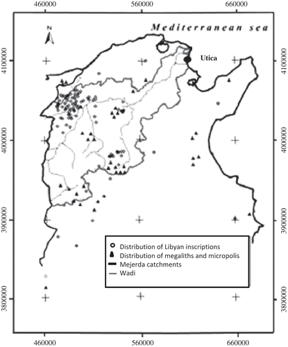
North African agriculture goes back to the end of prehistoric times. The native Numid farmers grew cereals using farming tools of the Bronze Age (Decret and Fantar Citation1981). These tools had the great advantage of ploughing only the arable shallow layer of the land and thus allowing sustainable soil exploitation. The Numidians (also called Libyans), had their territory in the western part of Carthage (Polybe et al. Citation1970). Archaeological investigations show that Numidic habitats covered a large portion of the Dorsal area and the Mejerda catchment (). The border of this area reached from the plateaus of the Constantine province to the Mejerda Valley. Their capital was located in the present town of Makthar in the centre of the Tunisian Dorsal (Lepelly and Dupuis Citation1999). The Numidian civilization was well organized, with economic and cultural contacts over the Mediterranean, as well as with the Egyptian civilization. When the Phoenicians came into contact with this native population, they found them well established with their own political, religious and administrative organization (Decret and Fantar Citation1981, Peyras Citation1991).
Fig. 1 Archeological investigations in the analysed Mejerda catchment. After DGRE (Citation1983) and Lepelly and Dupuis (Citation1999).
The Punic period (1000–146 BC)
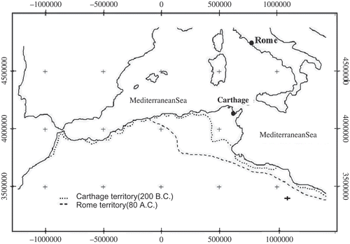
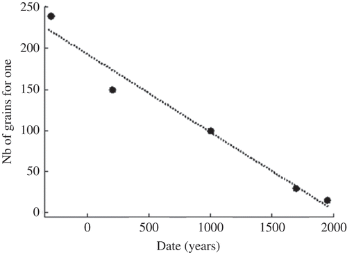
The Phoenician farmers from Tyr had to convert to trading because their lands had been devastated by water erosion, as a result of deforestation and intense exploitation of downstream areas (Lowdermilk Citation1953). They developed maritime trade in the occidental Mediterranean Sea. Thus, Phoenician traders settled downstream of the agricultural Numidic habitats at Utica, where the Wadi Mejerda discharges to the Mediterranean (). Historical texts indicate a political co-existence between the Phoenicians and Numids. For example, a special tax had to be paid to the landlords (Camps Citation1979). Moreover, a mixed Punic civilization, in which Numids and Phoenicians succeeded in connecting the Orient to the Occident, was embodied by the creation of Carthage (814 BC), which later became well-known for its economic wealth and military power. The original sustainable agriculture, as well as the old Phoenician “know how” developed in Mesopotamia and the Nile plains over several centuries, were put into practice. This resulted in rich cereal, olive and fruit crops that are mentioned in historical texts. Greek texts recognize that Numidia achieved abundance and over-production of cereals. This food excess was used for export (Jaidi Citation1990, CJB and EFR Citation1994). In the third century BC, Magon the Carthaginian wrote an agronomy book in 28 volumes that was translated by both the Greeks and Romans. In the reign of Massinissa (238–148 BC), Strabon writes about “double-crop lands, … the wheat yield was 240 grains for one …” (Decret and Fantar Citation1981, Lancel Citation1999).
When Carthage became the most important agricultural producer of the western Mediterranean (), it exploited the most fertile and richest areas of 300 Tunisian towns where sedentary life was usual (Lepelly and Dupuis Citation1999). On the eve of the destruction of Carthage by the Romans in 146 BC, and after six centuries of rule, the Numidic lands were overflowing with wheat and fruit of all sorts (Decret and Fantar Citation1981).
Fig. 2 Carthaginian and Roman territory in Tunisia. After Lepelly and Dupuis (Citation1999) and Lancel (Citation1999).
The Roman period (146 BC–600 AD)
At the beginning of the Christian era, Pliny the Elder described the province of Africa (now Tunisia) as “a fertile land where cereals are lovely and crops are huge, reaching 150 grains for one.” The Roman consumption of wheat was about 10 million quintals (Decret and Fantar Citation1981, Jaidi Citation1990). They considered the whole territory as property of the state and the native inhabitants had to pay taxes to Rome. Cereal farming covered Tunisia and the present Algerian lands of Constantine to the border of the desert (). All types of fields were needed for farming. Towards 380 AD, Rome suffered from a general agricultural crisis, as well as depopulation (Decret and Fantar Citation1981). Land where wheat had been intensively cultivated became exhausted and it had to be replaced by other crops.
Thus, an interest in tree planting (grape and olive trees) was born. This new farming trend focused on exploiting the soil's wealth to depth, after the surface layer of the soil was impoverished. People also resorted to irrigation in order to improve the yield. Moreover, the hill slopes destroyed by erosion necessitated a new kind of management. Consequently, terraces and water-harvesting devices were developed. A quotation by Coripe in the sixth century confirms the state of soil degradation and the persistence of the farmers in continuing non-sustainable exploitation of an over-exploited land: “… [T]he farmers of the altered land of Libya used to watch the clouds and when they saw the first flashes of lightening, the strokes of thunder, the gusts of wind they rushed to the dried fields and expected rain. They cleaned up, made the fields even to receive rain water in suitable paths, to prepare for greening fields they built sand obstacles on the slopes of the soil” (Decret and Fantar Citation1981). After nearly eight centuries of Roman rule, repeated Arab incursions occurred.
The Arab period (700–1500 AD)
The Arabic era (734 AD) was characterized by construction of large-scale hydraulic structures. These structures collected and stored surface water in order to provide support for a growing cattle-rearing industry. Instead of resorting to extending the farmland and irrigation, intensive cattle rearing seemed to be more suitable and beneficial for the soil conditions of that time. El Bekri (1000 AD) mentioned in his road notes that the cereal crops of the centre reached 100 grains for one, at best (cited by Sakiss et al. Citation1994, ). In the 11th century, conflicts led to the conversion of some of the region's population to a nomadic lifestyle. Thus, cities and town life started disappearing from the semi-arid area (Mahjoubi Citation1992). This Arabic period seems to have introduced farming systems that combined cereal farming and cattle breeding in agricultural areas. Pressure on the upper soil cover continued. Unfortunately, in no way was the inherited, historical, sustainable management knowledge taken into account in the context of land exploitation. Consequently, the area sank into more severe degradation.
Fig. 3 Average cereal yield from a single sowed grain.
The Ottoman period (1500–1880)
When Tunisia became part of the Ottoman Empire, the central administration made most of the farming lands its own property. The new owners were city dwellers living in luxury in the capital, Tunis. They hired people who collected taxes from the tribes on their behalf. The amount of taxation imposed on the land was higher than that imposed on cattle. Therefore, cattle rearing became more popular with the rural communities. The latter were indeed poor and frequently decimated by epidemics and starvation. Their situation clearly reflected that of their environment, which was eroded and poorly drained. Their cereal crops did not exceed 30 grains for one (Kassab Citation1979, ). Eventually, this farming technique was unsuccessful and the policy of increasing taxation was a failure, as it led to severe financial problems. All this induced France to benefit from the disastrous situation by colonizing Tunisia, which seemed strategically beneficial owing to its geographical location and its potential farming advantages, as mentioned in Roman texts.
Colonial period (1880–1956)
The French protectorate seized the Tunisian territory without any difficulty (Niox Citation1890), due to the degraded agricultural landscape and low rural population density. Moreover, Tunis, the cosmopolitan capital, drew a varied population from all over the Mediterranean due to its active trade. The new invader quickly started to develop agriculture on the vast lands and designed a plan to build big dams (Coignet Citation1917). Faced with the pressing needs of an increasing European population, France hoped to greatly increase its production through intensive agriculture. However, to its great surprise, the crop yield was only 15 grains for one (Gsell Citation1921, ). The cattle were hard to keep alive due to high mortality during dry periods. Once again, the perseverance and determination of the colonial power did not refrain from impoverishing the land even further. France also prevented the rural communities from developing by depriving them of their water resources and pushing them out of their own lands. This population was pushed towards the mountains and the marginal lands. Thus, degradation of the land worsened, and all means of safeguarding or re-establishing natural resources were simply ignored.
Modern-day Tunisia (1956–2010)
When independence came, soil exploitation continued and the French hydraulic policy (Coignet Citation1917) was wholly adopted by the new government. The main streams that flowed from the Dorsal area were chosen as privileged sites for water resources development. However, reservoir construction was undertaken without consideration of the upstream management of the watersheds involved. Therefore, water erosion and early sedimentation of dams were soon noticed. Despite efforts to avoid soil loss and to use new agricultural technology, cereal yields remained at 15 grains for one (DG/PA Citation2008, ). In spite of the adoption of a national policy for the protection of farming lands and for soil and water conservation, the erosion pressure was severe. The lack of environmental protection meant that the semi-arid area hardly developed (Gammar Citation1995).
HISTORICAL ACCOUNTS OF WATER EROSION IN THE MEJERDA CATCHMENT
Navigation through Mejerda
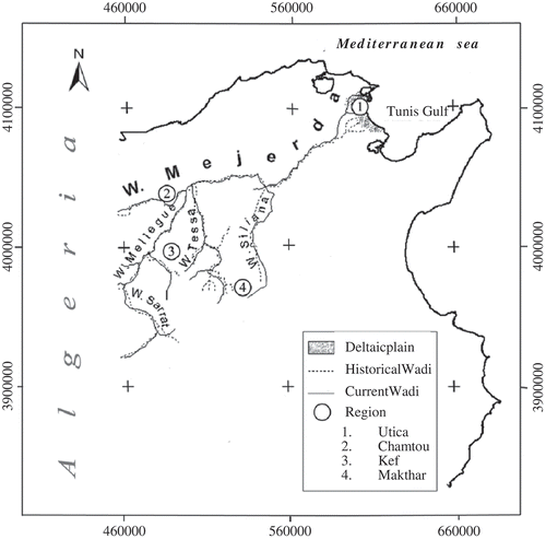
Most historical texts show that Wadi Mejerda could be used for navigation during the Numidic and Punic periods. The Phoenicians used to practice their sea trade along this river. Thus, they came into contact with the Numidic habitats and reached their populations in the most remote areas located on the plateau of Constantine. They sold colourful material, glassware, pearls, metal and pottery to the native people, and received local products (cereals, wood, animal skins, elephant tusks, raw metals, etc.) and cattle. (Rougé Citation1975, AIECM Citation1976, Decret and Fantar Citation1981, Lepelley and Dupuis Citation1999). During the Punic civilization, the river supplied the city of Utica, and then Carthage, and their respective harbours, with metals from Kef, marble from Chemtou and wood from the Dorsal (Barkaoui Citation2003, ). In addition, the river allowed the setting-up of a permanent military camp in Kef, 170 km from Carthage, where many thousands of mercenaries used to gather once back from wars against Rome (Lancel Citation1999, ). Two rock drawings illustrating war ships from archaic times (620 BC) were found in northwest Tunisia, in the continental part of Numidia, indicating navigation. Navigation on Wadi Mejerda appears very likely, owing to its morphology and especially its width, which varies from 35 to 170 m (Niox 1890, Abidi Citation2007, Zahar et al. Citation2008). This suggests that navigation by Carthaginian trade ships (max. width 5 m) and war ships (max. width 7.4 m) was possible (Barkaoui Citation2003, Lancel Citation1999).
Fig. 4 Comparison between the ancient (∼300 BC) and present Mejerda hydrographical network. After Lancel (Citation1999) and DGRE (1983).
Finally, Wadi Mejerda always represented a vital artery for the Punic maritime empire. This statement is confirmed by the description reported by Meyran (Citation2008) and related to the context of the collapse of Carthage. According to Meyran (Citation2008), the conquest of Carthage was only possible by barring the river and thus isolating the city from its supporting land areas.
Solid load and hydrographic network
Wadi Mejerda has been well described since the beginning of written history. The importance of its water and solid transport are mentioned by the poet Silius Italicus during the Punic wars (second century BC), “… a river with muddy troubled waters, and a slow flow that digs the dry sand, the Bagrada, and no other river on Libyan land extends its muddy waters and no longer the beds of its sleeping water sheets” (cited by Chelbi et al. Citation1995). This high solid load in Mejerda continued during the entire Roman period. It seems that navigation was prevented since about the beginning of the Christian era. The Romans built a large road network, likely to replace the navigation and ensure communication, commercial trade and military operations (Niox 1890, Decret and Fantar Citation1981).
A comparison between the ancient and the current hydrographic networks displays in general a rather stable situation (). However, an increase in the river length from 13 to 65 km has characterized the Mellegue and Siliana wadis, respectively. A probable first cause may be the population pressure that has always been strong in the watershed (). A second explanation for the increasing degradation may be the wood exploitation. Indeed wood was among the most valuable goods in the Mediterranean Sea trade cycle. Among the 14 recorded species from historical wrecks, the wood from the Atlas Mountains amounted to about half (Barkaoui Citation2003). The Siliana and Mellegue woods were rich in pines (Gammar Citation1979). This tree was highly valued for boat building because it creates light ships. This type of wood was transported to Carthage where round-shaped ships for trade and long-shaped ones for war were built. The carpenters assembled and launched boats on an average of one vessel every two days. This was done in order to cover the needs of the maritime empire (Barkaoui Citation2003). The nearest pine forest to Carthage via Mejerda was that of Siliana, which was subject to stronger pressure than the more distant Mellegue forest ().
Flooding and siltation
Over the last three centuries, more and more frequent overflowing of Wadi Mejerda during wet periods was noticed (Kassab Citation1979, Touchan et al. Citation2008). Consequently, water-logged areas were created both up- and downstream in the wadi, partly due to shifting of the main wadi channel and cut-off of older channels. These areas are malaria sources and this was probably a cause of the decrease in rural population density that characterized that time. In 1898, exceptional floods downstream led to silting of 3000 ha, which resulted in 50–100 cm deep deposits. During exceptional events, the amount of sediment load is excessive and can result in morphological changes of the wadi bed and channel. From 1931, during further floods, Wadi Mejerda overflowed again to its nearby older channels located in the area around its mouth (Jauzein Citation1971). In fact, geomorphologists have discovered six old channels like this (Oueslati et al. 2006). Indeed, Collet (Citation1953) states that, at the beginning of the last century, the Mejerda used to overflow every 2 or 3 years. The repeated overflowing developed 2-m high natural levees along its banks. The flood that occurred in the Mejerda catchment in 1973 was also devastating (Sakiss et al. Citation1991, 1994, Slimani Citation2001) and the subsequent sediment deposits were spectacular. The solids concentration reached 170 g/L and the water carried 100 × 106 t (4250 t/km2) of sediments (Claude et al. Citation1977, Ben Mammou Citation1998, ).
Before the building of dams in 1953, the Mejerda annual solid transport at the Gulf of Tunis amounted to 22 × 106 m3 (Pimenta Citation1959). This yields an average erosion of the entire watershed of 0.41 m/1000 years. At present, the annual solid transport by the Mejerda to the Gulf of Tunis amounts to 5 × 10⁶ t (SOGREAH Citation1992, Studi-Apal Citation2001). However, recent morphological changes show that the flattening of the river bed increased by 20% in 15 years. The decrease in flow was about 30%. Consequently, floods occur with a gradually decreasing discharge (DGRE 2006, Lebdi et al. Citation2006, Zahar et al. Citation2008).
During the last century, there were 12, seven and three large floods on the Mejerda in the periods 1900–1960, 1960–2000 and 2000–2007, respectively. The first period had, on average, two floods every 10 years and characterized a watershed that has been used in a non-sustainable manner regarding its resources. In the second period, there was a decrease in flood frequency to an average of 1.75 events per 10 years. This could be explained by the boom in building large dams in the catchment during the 1970s. The third period presented about four floods per decade, and perhaps illustrates the consequences of insufficient attention and insufficient means for adapting the management of the upper catchment areas. Frequent floods were recorded, together with rapid loss in the storage water capacity of reservoirs and choking of the hydraulic structures due to silting.
Soil loss and progression of the deltaic plain
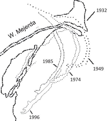
The Mejerda basin remains the most obvious evidence of the importance of soil loss. Its mouth used to be located 15 km away from its present location. Wadi Mejerda has created a deltaic downstream plain that has gained more than 450 km2 from the sea (Paskoff and Trousset Citation1993). Nowadays, this plain is intensively exploited by farmers. The chronology of its formation, as well as the importance of the climatic, hydrological and human factors in its evolution, have been well documented (Tissot Citation1884, Bernard Citation1911, Barjot Citation1952, Reyniers Citation1952, Jauzein Citation1971, Chelbi et al. Citation1995, Oueslati et al. 2006). Its extension is due to the existence of a sheltered, shallow coastal environment at the mouth of a river, characterized by an abundant solid load. The delta is made up of old off-shore bars, which delimit lagoons that have been slowly filled by silt (Paskoff Citation1985). The best image illustrating this phenomenon is the present “sandy arrow” of Kalaat Landalous, which originates at the river delta (). The latter is morphologically active; it is progressing at an average rate of 100 m/year and stretches nearly 4.5 km from north to south (Studi-Apal 2001, Sect-Tunisie-Apal Citation2005).
Fig. 5 Progress of the Mejerda delta. After Oueslati et al. (2006).
A trend of increasing solid transport over three millennia is clearly evident (). The average progress of the delta per century doubled between the second and the first millennia BC (); the advance grew from 6.6 to 12 km2/century. The maximum rate, 14.5 km2/century, was observed between 200 BC and 400 AD. Then, a tendency to decrease was noted and this continued until the 1900s (). The time of increasing rates perfectly coincides with the farming of the lands and their expansion through North Africa, as described by Jauzein (Citation1971).
Table 1 Development of the Mejerda delta plain (values deduced from the graphs of Jauzein (Citation1971) and Oueslati et al. (2006))
Fig. 6 Trend for increase of Mejerda deltaic plain. Source: the geomorphological studies of Jauzein (Citation1971) and Oueslati et al. (2006).
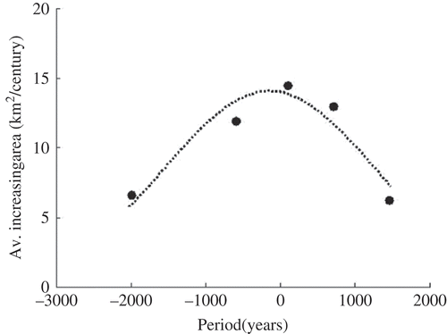
The intensive agricultural exploitation during the Roman period is well illustrated by the maximum amount of solid transport during the studied period. However, the decreasing tendency in solid transport during the last millennium may not be a result of land conservation. Rather, this is probably due to a decrease in sediment available to be carried downstream, and the graph coincides rather well with the soil degradation cycle suggested by Jebari et al. (Citation2010). Consequently, the progress of the Mejerda deltaic plain illustrates the temporal sedimentary dynamics for the semi-arid catchments ().
The soil degradation cycle characterizes the water erosion regime of the catchment and its current degradation level. These two parameters are crucial to deciding whether soil erosion control is urgently needed or not, and they indicate whether new adaptation measures are needed to face future challenges (Jebari et al. Citation2010). This overall context currently involves an international research effort focusing on anthropogenic impacts related to water resources management. It is hoped that this effort will result in findings useful for suggesting more suitable strategies (e.g. GOPA and GTZ 2005, Jebari et al. Citation2008, Yang et al. Citation2009, Bossio et al. Citation2010, EEA Citation2011). The latter would allow, for example, consideration of more appropriate hydro-agricultural techniques (e.g. type of hydraulic device, density rate, design format). These techniques, once installed, will then enable engineers to prevent water and soil resources depletion. In addition, they will promote implementation of integrated natural resources management within the rural degraded farmland catchments. This would be a great achievement in semi-arid areas where further potential sustainable development can be undertaken.
CONCLUSION AND DISCUSSION
During the last 3000 years, the Tunisian semi-arid area in general, and the Mejerda catchment in particular, have witnessed successive agricultural systems that have resulted in intensive exploitation rather than sustainable management of its natural resources. This has seriously affected the soil cover, the fertility level of the soils, the water erosion area, the wadi's hydrological and sedimentological regime, the morphological changes of the river bed and, finally, caused damage to the downstream infrastructure. The Mejerda watershed gives us an idea of the long- and short-term human impacts. In fact, it allows us to assume a soil degradation cycle over the last three millennia. Moreover, it reveals why floods became more frequent and how important sediment deposits were over the centuries.
During periods when water erosion became severe, farmers utilized different small-scale hydro-agricultural techniques to maintain their farming activities. These were needed to store and to spread water for irrigation. In addition, they created new soil substrata downstream when upstream soils were eroded. Nowadays, these traditional techniques are more or less forgotten. In fact, the centralized water and soil management turned the rural community into a passive actor.
However, we cannot abandon a watershed because it is eroded. The loss in the potential production of its arable lands must be regained, as well as its ability to store water. For this purpose, we must first define its degradation level, which indicates its general behaviour during exceptional events. History shows that it is important to promote a balanced pressure on land across the entire catchment. This can be performed by considering small and large hydraulic structures, which have to complement each other to prevent soil loss in an efficient way.
Finally, scientists, rural engineers and farmers have to jointly set up different schemes in order to establish water and soil conservation devices in the catchment. For this purpose, they need to take into consideration where the position of the hydrological unit is on the soil degradation cycle. When the sedimentological and hydrological characteristics continuously change due to water erosion processes, the hydrological calculations and resulting parameters should be revised. This would necessitate a better participation by hydrological researchers in the technological development of agricultural management. Eventually, this approach would strengthen the national policy for the water erosion control. Indeed, it would improve the plans of action and the efficiency of the development of projects in soil and water conservation aimed at preserving the farming areas and maintaining the water storage capacity of the reservoirs.
Acknowledgements
The authors thank Dr Taoufik Redissi from the National Institute of Patrimony (INP), Ms Rabaa Ben Salah from the Department of Agricultural Production (DG/PA) and Mr Mehdi Ben Haj from the Coastal Protection and Planning Agency (APAL), for the generous literature material, the interesting discussions and the valuable advice they provided. S. Jebari and R. Berndtsson acknowledge helpful funding from the Centre for Middle Eastern Studies through the MECW project at Lund University.
REFERENCES
- Abidi , M. 2007 . Etude et modélisation de la dynamique fluviale de l'oued Mellegue en période de crue , Institut National Agronomique de Tunisie . Thesis (MSc)
- AIECM (Actes congres International d'Etude des Cultures de la Méditerranée occidentale) . 1976 . Actes du 2e Congrès , Alger : Société nationale d'édition et de diffusion .
- Barbayiannis , N. , Panayotopoulos , K. , Psaltopoulos , D. and Skuras , D. 2011 . The influence of policy on soil conservation: a case study from Greece . Land Degradation and Development , 22 : 47 – 57 .
- Barjot , P. 1952 . Le Golf d'Utique dans l'antiquité. Le dessin d'Utique, de Carthage et de Bizerte . Revue Générale de l'Hydraulique , 68 : 59 – 68 .
- Barkaoui , A. 2003 . La marine carthaginoise. Approche des activités militaires des carthaginois sur mer depuis les origines jusqu'en en 146 av. J.-C , Sfax , , Algeria : Publication de la Faculté des Lettres et des Sciences Humaines de Sfax, Ouvrage édité par l'Or du Temps .
- Ben Mammou , A. 1998 . Barrages Nebeur, Sidi Salem, Sidi Saad et Sidi Boubaker. Quantification, études sédimentologique et géotechnique des sédiments piégés. Apport des images satellitaires , Thèse de Doctorat des Sciences Géologiques . Université de Tunis II, Faculté des Sciences de Tunis
- Bennet , H.H. 1950 . Manuel de conservation du sol N°53 , Publication du Département de l'Agriculture des Etats Unis .
- Bernard , C. 1911 . “ Le golfe d'Utique et les bouches de la Medjerda. Extrait du ” . In Bulletin de Géographie Historique et Descriptive , Paris : Imprimerie Nationale .
- Bossio , D. , Geheb , K. and Critchley , W. 2010 . Managing water by managing land: addressing land degradation to improve water productivity and rural livelihoods . Agricultural Water Management , 97 : 536 – 542 .
- Brázdil , R. and Kundzewicz , Z.W. 2006 . Historical hydrology—Editorial . Hydrological Sciences Journal , 51 : 733 – 738 .
- Camps , G. 1979 . Les Numides et la civilisation Punique . Antiquités Africaines , 14 : 43 – 53 .
- Chelbi , F. , Paskoff , R. and Trousset , P. 1995 . La baie d'Utique et son évolution depuis l'Antiquité: une réévaluation géoarchéologique . Antiquités Africaines , 31 : 7 – 51 .
- Claude , J. , Francillon , G. and Loyer , J.Y. 1977 . Les alluvions déposées par l'oued Medjerda lors de la crue exceptionnelle de mars 1973 . Cahier ORSTOM, Série Hydrologie , 14 : 37 – 109 .
- CJB and EFR (Centre Jean Bérar & Ecole Française de Rome) . 1994 . Le ravitaillement en blé de Rome et des centres urbains des débuts de la république jusqu'au haut empire , 14 – 16 . Naples : Février . Actes du colloque international organisé par le Centre Jean Bérard et l'URA 994
- Coignet , J. 1917 . La Medjerda: Hydraulique en Tunisie et les grands barrages réservoirs , Paris : Coyne and Bellier, Bureau d'ingenieurs conseils .
- Collet , C. 1953 . Les moyens mis en œuvres en Tunisie pour l'étude des crues de la Medjerda . La Houille Blanche , : 395 – 408 .
- Cremers , L. , Ooijevaar , M. and Boelens , R. 2005 . Institutional reform in the Andean irrigation sector: enabling policies for strengthening local rights and water management . Natural Resources Forum , 29 : 37 – 50 .
- Cunderlik , J.M. and Ouarda , T.B.M.J. 2009 . Trends in the timing and magnitude of floods in Canada . Journal of Hydrology , 375 : 471 – 480 .
- Darvishan , A.V.K. , Sadeghi , S.H.R. and Gholami , L. 2010 . Efficacy of the time–area method in simulating temporal variation of sediment yield in Chehelgazi watershed, Iran . Annals of Warsaw University of Life Sciences—SGGW, Land Reclamation , 42 : 51 – 60 .
- Decret , F. and Fantar , M. 1981 . L'Afrique du nord dans l'antiquité. Histoire et civilisation des origines au Ve siècle , Paris : édition Payot .
- DG/ACTA (Direction Générale des Aménagements et de la Conservation des Terres Agricoles) . 1993 . “ Stratégie nationale pour la conservation des eaux et des sols ” . In République Tunisienne, Ministère de l'Agriculture et des Ressources Hydrauliques , Direction de la Conservation des Eaux et des Sols .
- DG/PA (Direction Générale de la Production Agricole) . 2008 . Les terres céréalières en Tunisie: leurs distributions, leurs productions et leurs principales problématiques , Tunis : Atelier organisé par l'association des sols à l'UTAP (L'Union Tunisienne de l'Agriculture et de la Pêche) . en Juin
- DGRE (Direction Générale des Ressources en Eau) . 1983 . Carte du réseau hydrographique Tunisien; échelle: 1/1 000 000 , Tunis : Reproduction de l'Office de la Topographie et de la Cartographie .
- DGRE (Direction Générale des Ressources en Eau) . 2006 . Actualisation de la courbe de tarage de la station de Jedeida au pont route no. 7 , Tunis : Note interne de la Direction Générale des Ressources en Eau .
- EEA (European Environment Agency), 2011. Annual report and environmental statement [online]. European Environment Agency. http://www.eea.europa.eu/publications/annual-report-2010 (http://www.eea.europa.eu/publications/annual-report-2010) (Accessed: 15 September 2010 ).
- El Amami , S. 1984 . Les aménagements hydrauliques traditionnels de Tunisie , Tunis : Ministère de l'Agriculture, Centre de Recherche du Génie Rural .
- Ennabli , N. 1993 . Les aménagements hydrauliques et Hydro-Agricoles en Tunisie , Institut National Agronomique de Tunis . Ministère de l'Agriculture et des Ressources Hydrauliques
- Ennabli , N. 1995 . L'irrigation en Tunisie , Tunis : Ministère de l'Agriculture et des Ressources Hydrauliques . Institut National Agronomique de Tunis
- Falkowski , T. 2010 . Basement of the alluvia influence on the channel pattern in example of selected reach of the Pilica River . Annals of Warsaw University of Life Sciences—SGGW, Land Reclamation , 42 : 93 – 104 .
- FAO (Food and Agriculture Organization) . 1996 . Introduction à la gestion conservatoire de l'eau de la biomasse et de la fertilité des sols (GCES) , Rome , , Italy : FAO, Bulletin pédologique 70 .
- Gammar , A.M. 1979 . Etude et carte écologique de la région de Kessra (Dorsale Tunisienne) , France : Université Scientifique et Médicale de Grenoble . Thèse (de Doctorat de 3eme cycle)
- Gammar , A.M. 1995 . “ La dorsale Tunisienne, entre représentation linéaire et réalité régionale ” . In Actes du 2eme colloque du département de géographie du 14–16 Décembre. Manouba , Tunisia : Université de Tunis I . Faculté des Lettres
- Garcia-Ruiz , J.M. , Begueria , S. , Altorre , L.C. and Puigdefabregas , J. 2010 . Land cover changes and shallow landsliding in the flysch sector of the Spanish Pyrenees . Geomorphology , 124 : 250 – 259 .
- GOPA (German Consulting Group) and GTZ (German International Cooperation) . 2005 . “ Elaboration d'une stratégie nationale d'adaptation de l'agriculture tunisienne et des écosystèmes aux changements climatiques ” . In Pré-rapport 1ère phase , Preliminarily report study provided for the Tunisian Ministry of Agriculture .
- Gough, S., 2005. Historic and prehistoric hydrology of the Cache River, Illinois. Little River Research and Design [online], 1–48. http://www.emriver.com (http://www.emriver.com) (Accessed: 1 March 2011 ).
- Gsell , S. 1921 . Histoire ancienne de l'Afrique du Nord , Vol. I , Paris : Hachette .
- Hagene , T. 2010 . Everyday political practices, democracy and the environment in a native village in Mexico City . Political Geography , 29 : 209 – 219 .
- Jaidi , H. 1990 . L'Afrique et le blé de Rome au IVème et Vème siècle , Tunis : Publications de la Faculté des Sciences Humaines et Sociales de Tunis . Série histoire, vol. XXXIV
- Jauzein , A. 1971 . “ Les agents de la morphogenèse ” . In Evolution récente du delta de la Medjerda , Paris , , France : Ecole Normale Supérieure . Université de Paris VI, Cours et documents du Laboratoire de Géologie
- Jebari , S. 2003 . “ Les méthodes traditionnelles de CES et l'initiative Wocat ” . In République Tunisienne, Ministère de l'Agriculture et des Ressources Hydrauliques , Rapport interne de l'Institut National de Génie Rural . Eaux et Forêts
- Jebari , S. , Berndtsson , R. , Bahri , A. and Boufaroua , M. 2010 . Spatial soil loss risk and reservoir siltation in semiarid Tunisia . Hydrological Sciences Journal , 55 : 121 – 137 .
- Jebari , S. , Berndtsson , R. , Lebdi , F. and Bahri , A. 2008 . Sediment, discharge and precipitation variation in the Wadi Mellegue catchment during the last 50 years . Annales de l'INRGREF , 11 : 116 – 122 .
- Kassab , A. 1979 . L'évolution de la vie rurale dans les régions de la moyenne Medjerda et de Bèja-Mateur , Géographie : Faculté des Lettres et Science Humaines de Tunis . Thèse (de Doctorat Es-Lettres)
- Knight, M.M., 1928. Water and the course of empire in North Africa [online]. http://www.jstor.org (http://www.jstor.org) (Accessed: 3 February 2007 ).
- Lancel , S. 1999 . Carthage , Tunisie : Librairie Arthème Fayard . Cérès édition
- Lebdi, F., Fdhila, M.K., and Hzami, A., 2006. Modélisation de la dynamique fluviale de la Medjerda: impact de l'évolution morphologique du lit sur l'écoulement [online]. In: L'avenir des terres sèches: cas du bassin mediterranée. Conférence scientifique internationale, 19–21 Juin, Tunis. IRD (Institut de Recherche pour le Développement)-Mission en Tunisie. http://gwadi.org/sites/gwadi.org/files/TUNISunescoreport_LEDUC.pdf (http://gwadi.org/sites/gwadi.org/files/TUNISunescoreport_LEDUC.pdf) (Accessed: 22 February 2009 ).
- Lepelly , C. and Dupuis , X. 1999 . “ Frontières et limites géographiques de l'Afrique du nord antique ” . In Actes de la table ronde réunie à Paris les 2–3 Mai , Paris : Publication de la Sorbonne .
- Lowdermilk , W.C. 1953 . Conquest of the land-through seven thousand years , Washington , DC : US Government Printing Office .
- Mahjoubi , A. 1992 . “ La province romaine d'Afrique à la fin de l'époque sévérienne (235 ap. J.C.) ” . In Atlas National de Tunisie , Tunis : Centre d'Études et de Recherches Economiques et Sociales .
- Meyran , R. 2008 . Les derniers jours de Carthage , 104 Mondadori , , France : Les Cahiers de Science et Vie .
- Mikhailov , V.N. and Mikhailova , M.V. 2010 . Delta formation processes at the Mississippi River mouth . Water Resources , 37 ( 5 ) : 595 – 610 . doi: 10.1134/S0097807810050015
- Mollinga , P.P. 2009 . Towards the transdisciplinary engineer: incorporating ecology, equity and democracy concerns into water professionals' attitudes, skills and knowledge . Irrigation and Drainage , 58 : 195 – 204 .
- Niox, Colonel, 1890. Géographie militaire (VI)—Algérie et Tunisie [online]. Paris: Librairie militaire de L. Baudoin et Cie Imprimeurs—editeurs. http://aj.garcia.free.fr/geographie_alg/pdf/chap2-2_2.pdf (http://aj.garcia.free.fr/geographie_alg/pdf/chap2-2_2.pdf) (Accessed: 7 January 2011 ).
- Nunes , A.N. , Coelho , C.O.A. , De Almeida , A.C. and Figueiredo , A. 2010 . Soil erosion and hydrological response to land abandonment in a central inland area of Portugal . Land Degradation and Development , 21 : 260 – 273 .
- Oueslati, A., Charfi, F., and Baccar, F., 2006. La basse vallée de oued Medjerda et la lagune de Ghar El Melh [online]. Wadi Project, Water Demand Integration. Fifth international meeting, INCO-CT-2005-015226. Presentation of the Tunisian site, 6–9 December, Tunis. http://www.wadi.unifi.it/tunisian_study_site.pdf (http://www.wadi.unifi.it/tunisian_study_site.pdf) (Accessed: 12 December 2008 ).
- Paskoff , R. 1985 . Les plages de la Tunisie , Caen : Editec .
- Paskoff , R. and Trousset , P. 1993 . L'ancienne baie d'Utique: du témoignage des textes à celui des images satellitaires . Mappemonde , 1 : 30 – 34 .
- Peyras , J. 1991 . Etude d'antiquités africaines. Le Tell nord-est tunisien dans l'antiquité , France : Centre National de la Recherche Scientifique, Essai de monographie régionale .
- Pimenta , J. 1959 . Le cycle Pliocène actuel dans les bassins paraliques de Tunis. Mémoirs de la Societé Géologique de France 85
- Polybe , E. , Büttner-Wobst , T. and Teubner , C. 1970 . La Pléiade 1882 – 1904 . trad. Française de D. Roussel, collré-éd. 1962–1963
- Popek , Z. 2010 . Variability of bedload transport rate during flood flows in the Zagozdzonka River . Annals of Warsaw University of Life Sciences – SGGW Land Reclamation, , 42 : 69 – 77 .
- Radziejewski , M. and Kundzewicz , Z. 2004 . Detectability of changes in hydrological records . Hydrological Sciences Journal , 49 : 39 – 51 .
- Reyniers , F. 1952 . Port à Utique , La société des antiquaires de France .
- Rougé , J. 1975 . La marine dans l'Antiquité , Paris : Presses Universitaires de France .
- Sakiss , N. , Ennabli , N. and Slimani , M.S. 1991 . La pluviométrie en Tunisie , Tunis : Institut National Agronomique de Tunis et Institut National de la Météorologie .
- Sakiss , N. , Ennabli , N. , Slimani , M.S. and Baccour , H. 1994 . La pluviométrie en Tunisie a-t-elle changé depuis 2000 ans? , Tunis : Production commune de l'Institut National de la Météorologie . Institut National Agronomique de Tunisie et l'Agence Nationale de Protection de l'Environnement. Imprimerie Officielle de Tunisie
- Sect Tunisie-Apal (Société Centrale pour l'Equipement du Territoire, Tunisie – Agence de Protection et d'Aménagement du Littoral, Tunisie) . 2005 . Campagne de reconnaissance de gites de sable en mer pour le rechargement de plages sous lot nord. Etude réalisé pour le compte du Ministère de l'Environnement et du Développement Durable
- Slimani , M.S. 2001 . Les inondations en Tunisie , Tunis : Institut National Agronomique de Tunis, internal report .
- SOGREAH . 1992 . Cité touristique de Gar El Melh. Etude préliminaire des problèmes d'hydraulique et connexes Tunisie Rapport no. 351486 établi pour le compte de KAL
- Studi-Apal (Société Tunisienne d‘Ingénierie – Agence de Protection et d'Aménagement du Littoral Tunisien) . 2001 . Etude de protection du site abri de pêche côtière de Kalaat Landalous. Rapport phase II Etude faite pour le compte des Ministères de l'Agriculture et des Ressources Hydraulique et de l’Équipement et de l'Habitat
- Subash , N. , Sikka , A.K. and Ram Mohan , H.S. 2011 . An investigation into observational characteristics of rainfall and temperature in Central Northeast India—a historical perspective, 1889–2008 . Theoretical and Applied Climatology , 103 : 305 – 319 .
- Sullivan , C.A. 2011 . Quantifying water vulnerability: a multi-dimensional approach. . Stochastic Environmental Research and Risk Assessment , 25 : 627 – 640 .
- Tissot , C. 1884 . Géographie comparée de la province romaine d'Afrique , Paris : Imprimerie Nationale .
- Touchan , R. , Meko , D.M. and Aloui , A. 2008 . Precipitation reconstruction for Northwestern Tunisia from tree rings . Journal of the Arid Environment , 72 : 1887 – 1896 .
- Vanwalleghem , T. , Laguna , A. , Giraldez , J.V. and Jimenez-Hornero , F.J. 2010 . Applying a simple methodology to assess historical soil erosion in olive orchards . Geomorphology , 114 : 294 – 302 .
- Yang , T. , Chen , X. , Xu , C.-Y. and Zhang , Z.C. 2009 . Spatio-temporal changes of hydrological processes and underlying driving forces in Guizhou region, southwest China . Stochastic Environmental Research and Risk Assessment , 23 ( 8 ) : 1071 – 1087 . doi: 10.1007/s00477-008-0278-7
- Zahar , Y. , Ghorbel , A. and Albergel , J. 2008 . Impact of large dams on downstream flow conditions of rivers: aggradation and reduction of the Medjerda channel capacity downstream of the Sidi Salem dam Tunisia . Journal of Hydrology , 326 : 318 – 330 .
- Zucca , C. , Canu , A. and Previtali , F. 2010 . Soil degradation by land use change in an agropastoral area in Sardinia (Italy) . Catena , 83 : 46 – 54 .