Abstract
The SWAT hydrological model was applied to analyse the impacts of climate changes on the flow and sediment production regimes in the Concórdia River drainage basin, in southern Brazil. Climate scenarios A2 and B2 of the IPCC were used to simulate basin behaviour over the period 2071–2100 and to compare it with that in the baseline period (1961–1990). Runoff and sediment yield calculated on a monthly basis in the calibration period gave Nash-Sutcliffe coefficients of 0.82 and 0.83, respectively, showing good model fit. Comparison of simulations for scenarios A2 and B2 with the baseline showed a reduction in flow of 39.2% and 41.2%, respectively. Analysis of daily values and extreme events suggested that flood peaks could reach more extreme values in the future, especially under Scenario A2. Time series of rainfall do not show significant departures from basin mean values, although Scenario B2 and, in particular, Scenario A2, show greater maximum values. Sediment production follows the same pattern as basin streamflow.
Editor Z.W. Kundzewicz
Citation Perazzoli, M., Pinheiro, A., and Kaufmann, V., 2013. Assessing the impact of climate change scenarios on water resources in southern Brazil. Hydrological Sciences Journal, 58 (1), 1–11.
Résumé
Le but de cette étude était d'appliquer le modèle hydrologique SWAT afin d'analyser les impacts des changements climatiques sur les régimes d'écoulement et de production de sédiments dans le bassin de la rivière Concórdia, dans le Brésil méridional. Les scénarios climatiques A2 et B2 du GIEC ont été utilisés pour simuler le comportement du bassin sur la période 2071–2100 et le comparer au comportement sur la période de référence (1961–1990). Les coefficients de Nash-Sutcliffe sur la période de calage, calculés sur une base mensuelle, ont été de 0,82 et 0,83 respectivement pour les débits et les apports sédimentaires. La comparaison des simulations pour les scénarios A2 et B2 avec la référence a montré des réductions de débit respectives de 39,2% et 41,2%. L'analyse des valeurs journalières et des événements extrêmes a suggéré que les pointes de crue atteindront des valeurs plus importantes à l'avenir, en particulier sous le scénario A2. Les séries chronologiques de précipitations ne montrent pas des écarts significatifs aux valeurs moyennes à l'échelle du bassin, bien que le scénario B2 et particulièrement le scénario A2, montrent des valeurs maximales supérieures. La production en sédiments suit la même comportement que le débit du bassin.
INTRODUCTION
Many studies have shown that the hydrological processes in drainage basins can be very sensitive to changes in temperature, rainfall and increased atmospheric CO2. Increasing trends in surface temperature have been shown to exist, with consequent effects on the hydrological cycle and drainage basin processes (Parajuli Citation2010). Wigley and Raper (Citation2001), Nearing et al. (Citation2005) and Githui et al. (Citation2009) state that, with increasing global temperatures, changes in the hydrological cycle will become increasingly marked. Rainfall and evapotranspiration are the most affected, and such changes may affect water availability and sediment production, as well as modifying the hydrological regime and river basin response. Greater losses of soil occur in regions where variability in rainfall and runoff is high (Marshall and Randhir Citation2008).
The effects of different future climate conditions are being simulated for drainage basins ranging in size from very small to very large in many parts of the world, in order to evaluate the potential impacts of climate change on water resources (Jha et al. Citation2006, Bekele and Kanapp Citation2010). Predictions of the effects of climate change on surface runoff and groundwater recharge vary widely, depending on the region and the climate scenario used; so do projected changes in rainfall. For example, the amplitude and frequency of high flows are projected to increase in most regions of the world, and those of minimum flows will be smaller (Krol and Bronstert Citation2007, Mello et al. Citation2008).
The principal tools used to explore the potential effects of climate change and changing land use are hydrological models (Parajuli Citation2010). Notable amongst them is the Soil and Water Assessment Tool (SWAT; Arnold et al. Citation1998) developed in the early 1990s for use by the Agricultural Research Service (ARS) of the United States Department of Agriculture (USDA).
Over the last decade, use of the SWAT model has increased steadily throughout the world. It has been applied to many basins, at various scales and conditions (Gassman et al. Citation2007). It has been used by various government agencies, particularly in the USA and European Union (EU), to evaluate the impacts of different scenarios including changes in climate and soil use.
The purpose of this study was to use the SWAT model to analyse the impacts of climate change on the flow regime and sediment production in the Concórdia River drainage basin of southern Brazil. Projections were based on the climate scenarios A2 and B2, developed by the Intergovernmental Panel on Climate Change (IPCC Citation2007) for the years 2071–2100, and these were compared with baseline data for the period 1961–1990.
METHODOLOGY
Study area
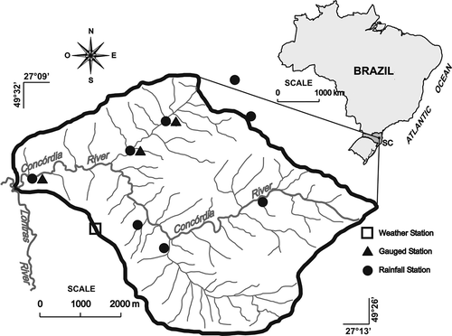
The Concórdia River drainage basin lies in the Lontras municipality in the southern State of Santa Catarina, Brazil. It is mainly agricultural with an area of 30.74 km2 (), and is a sub-basin of the larger Itajaí River basin, the State's largest basin, draining to the Atlantic Ocean.
Fig. 1 The Concórdia River drainage basin and its monitoring sites.
The predominant soils in the basin are Cambisols, Gleissols and Argisols. Using the Thornthwaite classification, the regional climate is defined as Humid Mesothermic of type B3 B′3 ra′, with no definite dry season and with annual rainfall of between 1600 and 1800 mm. Using the Köeppen classification, the climate is Cfa. The original vegetation is Dense Ombrophilic Forest. Land use is given as 46.75% native forest, 20.46% grassland, 11.12% reforested area (Pinus and Eucalyptus), 9.81% under maize cultivation, 7.16% general agriculture, 4.11% water bodies and 0.59% under tobacco cultivation (Pinheiro et al. Citation2008).
The monitoring network shown in was set up in 2006. There are eight recording raingauges, three flow-gauging stations (two with Thalimedes OTT water-level sensors and one with a weir), a turbidity meter (ANALITE MCV-CEP 9530-G, 0–3000 NTU resolution), and a full meteorological station. Sediment samples are also collected at the flow-gauging stations using rising-level samplers (ANA) and falling-level samplers (AND). Installation and function of these samplers is described by Paranhos et al. (Citation2002).
This monitoring network also provided the meteorological and hydrological data used in the study. Data on the physical and hydrological characteristics of soils were taken from Teixeira (Citation2008), who analysed soil from 20 sites in the basin at different depths (0–20, 40–60 and 80–100 cm) giving a total of 60 samples. Values of apparent specific mass, levels of clay, silt and sand content, saturated hydraulic conductivity and organic carbon were also taken from Teixeira (Citation2008), who concluded that, in hydrological terms, the basin's soils belong to Group C. Another necessary parameter, albedo, was estimated from soil colour, determined by visual comparison with the Munsell chart.
Map data used in the model were obtained from a digital terrain model (DTM) and the hydrographic network, both derived from topographic maps and aerial photographs of the Instituto Brasileiro de Geografia e Estatística (IBGE); these gave a topographic map at the scale 1:10 000. Also used were a map of land use obtained from supervised classification of a SPOT5 satellite image at 10-m spatial resolution in four spectral bands, and a map of soil type developed from interpolation by Depiné (Citation2011). All raster images used a spatial resolution of 10 m. Most of the graphic data were generated by Lubitz (Citation2009).
Future climate scenarios
The climate scenarios used in the study were those defined by the IPCC (2007). The Scenario A2 (high emission) is considered to be pessimistic in terms of greenhouse-gas emissions. Regional economic growth is highly heterogeneous, and the large difference at present existing between mean income of industrialized countries and that of countries in the course of development is not reduced. The scenario assumes a large population increase, reaching 15 billion in 2100. According to this scenario, the Earth's average temperature will increase by 2–5.4°C by 2100 (Nakicenovic and Swart Citation2000).
The B2 scenario (low emission) is considered optimistic about greenhouse-gas emissions. The large differences in income are maintained and mechanisms for technological transfer are not very efficient; however, policies give priority in general to education and technological innovation in cities, so that, for example, people are less dependent on cars. The scenario assumes increasing concern about environmental and social sustainability in the world as a whole, with decentralized government permitting organized and environmentally-conscious society. Population reaching 10 billion in 2100 is assumed, as well as a temperature increase of 1.4–3.8°C (Nakicenovic and Swart Citation2000).
Global climate models (GCMs) describe atmospheric behaviour using a three-dimensional grid covering the planet with a spatial resolution of between 250 and 600 km. For studies at a regional level, and particularly at the river-basin scale, downscaling is necessary. Regional climate models (RCMs) are used for this purpose (Miller et al. Citation1999, Krol and Bronstert Citation2007). Dynamical downscaling fits output from GCMs into regional meteorological models. Rather than using equations to bring global-scale projections down to a regional level, dynamic downscaling involves using numerical meteorological modelling to reflect how global patterns affect local weather conditions (Miller et al. 1999).
Using regional-scale models, it becomes possible to identify particular climatic features within a region at a more detailed level, and such models are essential for studies of local impacts, giving better description of climate in specific regions than that obtained from global models (Betts et al. Citation2011, Campos Citation2011). A number of authors have reported the use of downscaling in the South American context, including Teixeira et al. (Citation2002), Chou et al. (Citation2002), Fernandez et al. (Citation2006), and Alves and Marengo (Citation2010).
Data for the climate scenarios for 2071–2100 in the Concórdia River basin were provided by the Brazilian Institute for Space Research, INPE. The scenarios were generated at 50-km spatial resolution (0.5° latitude × 0.5° longitude) and temporal resolution of one day, using the regional climate model HadRM3P of the Hadley Centre, UK. This model is part of the Integrated System of Regional Modelling PRECIS—PRoviding REgional Climate for Impact Studies (Marengo et al. Citation2009).
The PRECIS system is used for simulating regional climate (Jones et al. Citation2004). It was developed in order to provide scenarios of regional climate with high spatial resolution relatively simply and at low computational cost. It has been widely used and has proved an important tool for studies of climatic vulnerability in a number of countries, including China (Xiong et al. Citation2007), Brazil (Alves and Marengo Citation2010, Campos Citation2011), Pakistan (Akhtar et al. Citation2009), Bangladesh (Islam et al. Citation2008), Mexico (Karmalkar et al. Citation2011), Russia (Shahgedanova et al. Citation2010), India (Kumar et al. Citation2011), Israel and Jordan (Black Citation2009) and South Africa (Engelbrecht et al. Citation2009).
To explore the consequences of climate change, two time periods were used when running the regional climate model. The first represents the most recent climatic conditions, whilst the second represents the more distant future when climate changes will be more apparent (Jones et al. 2004). Thus the 30-year period from 1961 to 1990 was used as a baseline for the regional climate model. Future scenarios were generated for rainfall, maximum and minimum temperatures, wind speed, relative humidity and solar radiation, all of which were needed for input to the SWAT model, simulating the following scenarios:
| none | Baseline: climate data observed during the period 1961–1990. | ||||
| none | Scenario A2: assuming high emissions of greenhouse gases, and regarded as a more pessimistic scenario; future simulations of climate are used for the period 2071–2100. | ||||
| none | Scenario B2: assuming lower emissions of greenhouse gases, and regarded as a more optimistic scenario; future simulations of climate are used for the period 2071–2100. | ||||
SWAT model
The SWAT is a hydrological model that allows the physical processes in drainage basins to be simulated, namely evapotranspiration, infiltration, surface runoff, and subsurface and groundwater flow. It can be used to calculate hydrographs and sedimentographs, and to obtain spatial information by simulating different scenarios (Neitsch et al. Citation2005).
The input data needed for SWAT describe land use and occupation, soil parameters, climate, relief and hydrological characteristics of the area under study, and these can be correlated with physical characteristics of the drainage basin. Data are input using a graphical interface of GIS software (ArcView or MapWindow) and are organized as tables and cartographic information sheets. Graphical data correspond to soil-use maps, pedological maps, drainage systems and a digital terrain model (DTM). Tables are used for climate data (wind, rainfall, temperature, solar radiation and relative humidity).
Basically, the SWAT model considers the basin to be divided into sub-basins defined by relief, soils and land use, preserving the spatially-distributed parameters of the whole basin and homogeneous characteristics within it. Sub-basins are divided into hydrological response units (HRUs) that represent unique combinations of soil use, soil type and slope class. The HRUs do not interact with each other. The responses of each HRU in terms of runoff, sediment and nutrients are calculated separately and then summed to give the total sub-basin response.
In the present study, 23 sub-basins and 877 HRUs were created, giving what was considered a satisfactory representation of basin heterogeneity. Runoff was calculated using the Curve Number (CN) method, with potential evapotranspiration calculated using the Priestley-Taylor method. Sediment production generated by surface runoff was estimated for each HRU by means of the Universal Soil Loss Equation (MUSCLE).
Calibration of SWAT
Calibration of the SWAT model was by means of water balance and the modelling of runoff and sediment production. Model parameters were adjusted so as to reproduce data sequences observed at the basin monitoring stations in the periods January 2001 to December 2010 for flow, and November 2008 to May 2009 for sediment.
To evaluate model fit, the Nash-Sutcliffe efficiency coefficient (COE) was used, since this is the most commonly-used measure of hydrological model efficiency. It is given by:
In addition to COE, the coefficient of residual mass (CMR) was used to show when the model over-estimated (giving negative values) or under-estimated (positive values) the observed sequence; it is given by:
Having calibrated on runoff and sediment production, the future climate scenarios were input to SWAT, namely A2, with high emissions of greenhouse gases, and B2, with low emissions of greenhouse gases, for the period 2071–2100, together with the baseline data from PRECIS, corresponding to the period 1961–1990.
RESULTS AND DISCUSSION
Calibration
shows results of calibrating the SWAT model using runoff and sediment production. and show comparisons of observed and simulated sequences. The CMR shows that, for runoff, the difference is very small, for both daily and monthly time-intervals, indicating that the volumes of observed and simulated runoff were very similar. In the case of sediment production, daily CMR was satisfactorily small, but monthly CMR showed that simulated sediment yield was rather lower than that observed. Krysanova et al. (Citation1998) state that, for a good model fit, the Nash-Sutcliffe coefficient should not be less than about 0.7 or 0.8. As shown in , COE values for the monthly time interval exceeded this range, for both runoff and sediment production, indicating that the SWAT model gave a satisfactory fit in the Concórdia River basin at this time interval. Inspection of the observed and simulated hydrographs in shows that both low and high flows were adequately simulated.
Table 1 Parameters showing model fit
Fig. 2 Daily streamflow: simulated vs observed.
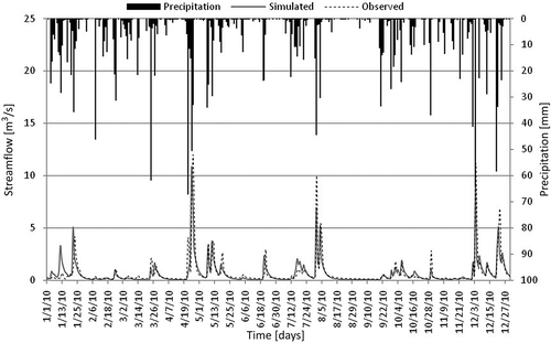
Fig. 3 Daily sediment yield: simulated vs observed.
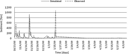
compares observed and simulated daily sediment production, showing that the model reproduced the observed distribution of production through time; however, since the sequence available for calibration was very short, some of the peaks were not adequately fitted. Nevertheless, as mentioned above, the fit to sediment production was considered satisfactory for the purpose.
Climate change scenarios
shows mean daily values of meteorological variables used in the three simulated scenarios. It can be seen that mean daily solar radiation is lower in the baseline scenario than in the A2 and B2 scenarios. gives a comparison and summary of runoff simulated by SWAT for the 30-year period. Scenarios A2 and B2 correspond to the period 2071–2100, and the baseline to 1961–1990.
Table 2 Daily weather data and annual precipitation
Table 3 Comparison between scenarios: simulated daily streamflow
In the case of total runoff, both the A2 and B2 scenarios gave values lower than that observed in the baseline period, with reductions of 39.3% and 40.8% respectively. Mean flow was also lower in the future scenarios, with similar percentage reductions (39.2% and 41.25%). Results for minimum flows were similar for both scenarios and for the baseline value. Regarding maximum values, the pessimistic Scenario A2 gave the most extreme value. These results showing reductions in mean flow for future scenarios correspond to those of Fontaine et al. (Citation2009), who evaluated the impacts of climate change on water yields in the Spring Creek basin of the Missouri River in South Dakota, USA. These authors found a reduction of about 39% in mean annual flow. Santana et al. (Citation2011) evaluated the impacts of climate change in the São Francisco River basin, Brazil, and concluded that flows would be reduced under future scenarios, relative to those observed in the period 1961–1990. The greatest reduction, 35% on average, was obtained for the more pessimistic Scenario A2; for the B2 scenario, mean flows were reduced by 12%–17%.
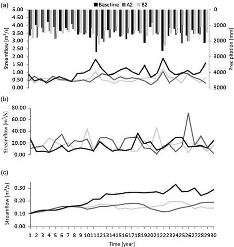
shows the evolution and distribution of annual flows for each simulated scenario over the 30-year period. (a), giving mean annual flows, shows that the baseline values are higher for most of the period. (b) shows annual maximum flows; it is seen that both A2 and B2 scenarios show the greatest peak flows, with A2 having the greatest extreme value and B2 the greatest number of peaks. (c) shows values of annual minimum flows; for both A2 and B2 scenarios, values are lower than for baseline conditions.
Fig. 4 Comparison of annual streamflows: (a) average; (b) maximum; and (c) minimum.
shows maximum and minimum flows for different return periods, obtained as the inverse of the probability that a hydrological event be equalled or exceeded at least once.
Table 4 Maximum and minimum streamflows (m3/s) for different return periods
In the case of minimum flows, it can be seen that, for the 10-year return period, the baseline value is greater than for the A2 and B2 scenarios. For return periods greater than 20 years, minimum flows under the future scenarios were all greater than baseline, particularly at the 100-year return period when they were greater by a factor of four: 0.02 m3/s for baseline, compared with 0.08 m3/s for scenarios A2 and B2. This demonstrates that scenarios of the future will generate minimum flows that are particularly extreme. In the case of maximum flows, scenarios A2 and B2 gave values greater than baseline at all return periods, the A2 scenario giving greater values than those under Scenario B2. Thus maximum flows attained even more extreme values under future scenarios, particularly under A2. This suggests that there could be greater problems, in future, from extreme floods.
gives flow values with frequencies of occurrence 80%, 85%, 90%, 95% and 98%. These minimum values have been adopted as reference values for purposes of resource management, in which a value represents the upper limit for water taken from a water-course (Silva et al. Citation2006).
Table 5 Reference streamflows (m3/s)
For all reference flows, scenarios A2 and B2 gave values lower than baseline, those for A2 being lowest. This indicates that the available water in the basin could be slightly less in future, particularly under the A2 scenario, despite the fact that extreme flows will be greater. These results can be compared with the conclusions of Salati et al. (Citation2009), who studied the influence of climate change in the major drainage basins of Brazil. These authors concluded that for the major basin draining to the South Atlantic (in which the study area lies), climate would remain moist under both A2 and B2 scenarios with little or no water deficit. Of the 12 hydrographic regions that they studied, only two will retain the same characteristics in future: the region draining to the South Atlantic, and that of the River Uruguay. The southern part of Brazil was the region least affected in terms of hydrological classification (Salati et al. Citation2009).
shows mean monthly flows over the 30-year period, with reductions in mean monthly flow under the future scenarios. The most notable decrease is in July, where the baseline mean was 31.91 m3/s compared with 8.99 m3/s under scenario A2 and 9.85 m3/s under B2. These values are about 28% and 31% of baseline values, for that month. The smallest difference was in December; the baseline mean flow was 28.49 m3/s, compared with 21.93 m3/s under Scenario A2 and 25.10 m3/s under B2; these values are 77% and 88% of baseline values, respectively.
Table 6 Monthly average streamflows (m3/s)
These results can be explained in terms of the frequency distribution of rainfall. The means of both daily and annual rainfall () are broadly similar for baseline and scenarios A2 and B2, although baseline means were higher for both time intervals. The mean daily values are practically equal in all three scenarios, with a standard deviation between them of 0.05 mm. For mean annual values, the mean annual rainfall for A2 was less than baseline by 8.92 mm, whilst for B2 it was 46.81 mm less. This shows that there will be no significant change in mean basin rainfall. However, when the frequency distribution of daily rainfall is considered, its evolution is found to be different for the three scenarios; shows their frequency curves for daily rainfall where, for easier viewing, only frequencies up to 5% are shown.
Fig. 5 Frequency distribution of daily rainfall.
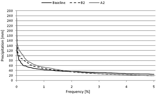
At 2% frequency, daily rainfall is similar for all three scenarios, and is about 30 mm. As frequency diminishes below this 2% value, it is evident that the A2 scenario has increasingly higher values, relative to baseline and B2, reaching a maximum of 250 mm. The B2 scenario also shows higher values relative to baseline, reaching a maximum value of 181 mm. As reported by Marengo et al. (Citation2011), who evaluated climate changes and extreme events in Brazil, under future scenarios, indices of extreme rainfall show increases in the frequency of extremes, and in their intensities, in southern and southeastern Brazil.
Sediment
, comparing daily sediment transport for the simulated scenarios, shows that totals and mean values are very similar for baseline and the A2 scenario, whilst those for the B2 scenario are lower. In the case of minimum values, scenario B2 has the lowest value of all three scenarios, whilst the greatest maximum value was recorded under the A2 scenario. This confirms that the more extreme events under A2 generate greater sediment loads in the basin, and are likely to have significant effects on soil conservation and silting-up of water bodies. In related work, Lelis et al. (Citation2011) simulated the effects of IPCC future scenarios to evaluate impacts of climate change on erosion processes in the sub-basin of São Bartolomeu River at Viçosa in the State of Minas Gerais, Brazil. They found rates of soil loss and runoff much greater than those observed at the present time, with values up to three times greater.
Table 7 Daily sediment yields: comparison between scenarios
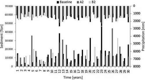
shows the evolution of production and/or sediment transport over the 30 years for which the three scenarios were simulated. The baseline scenario showed the greatest values for sediment production; this is explained by the precipitation regime, where more intense rainfalls generated greater sediment production.
Fig. 6 Comparison of annual sediment production of future scenarios and the baseline.
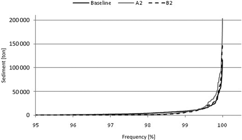
, giving the frequency curves for daily sediment production, shows that scenarios A2 and B2 result in values higher than baseline; in addition, the most extreme value for sediment production occurred under the A2 scenario.
Fig. 7 Frequency curves for daily sediment production.
CONCLUSION
The SWAT hydrological model was calibrated for the Concórdia River drainage basin, giving monthly values of the Nash-Sutcliffe efficiency coefficient of 0.82 for runoff and 0.83 for sediment. Having calibrated the model, runoff and sediment yield were simulated for two future climate scenarios, A2 and B2, respectively more pessimistic and more optimistic, in terms of carbon emissions and the baseline scenario (1961–1990).
The results show that impacts resulting from the A2 and B2 scenarios vary as a function of time scale. At monthly and annual time intervals, mean flows, and maximum and minimum flows are greater for baseline conditions than for the two scenarios A2 and B2. It was found that there would be a reduction of mean total flow of 39.2% and 41.2%, realtive to the baseline, under scenarios A2 and B2. However, when daily values are analysed in terms of extreme events, it was shown that peak flows would attain more extreme values under the future scenarios, especially for A2. This suggests that, in the future, there may be greater problems arising from the occurrence of extreme events of flood and drought. The effects were generated from time series of rainfall, which do not show significant change in mean values for the basin, although Scenario B2 and especially Scenario A2 show greater maximum values.
It was also found that sediment yields follow the same pattern as basin runoff. Greatest production of sediment was generated under the A2 scenario. This confirms that the more extreme events of Scenario A2 are likely to generate greater sediment transport within the basin, with significant impacts on soil conservation and silting-up of water bodies.
Acknowledgements
We thank MCT/FINEP/AÇÃO TRANSVERSAL (Climate and Weather Forecasting 04/2008, grant 1406/08, project 01.08.0568.00), for funding the research; Dr José A. Marengo of INPE for providing PRECIS data; and CAPES for awarding a Master's scholarship.
REFERENCES
- Akhtar , M. , Ahmad , N. and Booij , M.J. 2009 . Use of regional climate model simulations as input for hydrological models for the Hindukush-Karakorum-Himalaya region . Hydrology and Earth System Sciences , 13 ( 7 ) : 865 – 902 .
- Alves , L.M. and Marengo , J. 2010 . Assessment of regional seasonal predictability using the PRECIS regional climate modeling system over South America . Theoretical and Applied Climatology , 100 : 337 – 350 .
- Arnold , J.G. 1998 . Large area hydrologic modeling and assessment, Part I. Model development . American Water Research Association , 34 : 73 – 89 .
- Betts , R. 2011 . “ Como modelamos o clima ” . In Riscos das mudanças climáticas no Brasil , Edited by: Marengo , J.A. and Betts , R. São José dos Campos: INPE; Devon: METOFFICE . In33–38
- Bekele , E.G. and Knapp , H.V. 2010 . Watershed modeling to assess impacts of potential climate change on water supply availability . Water Resources Management , 24 : 3299 – 3320 .
- Black , E. 2009 . The impact of climate change on daily precipitation statistics in Jordan and Israel . Atmospheric Science Letters , 10 : 192 – 200 .
- Campos , C.G.C. 2011 . Padrões climáticos atuais e futuros de temperatura do ar na Região Sul do Brasil e seus impactos nos cultivos de pêssego e de nectarina em Santa Catarina Thesis (PhD)Instituto Nacional de Pesquisas Espaciais
- Chou , S.C. 2002 . Validation of the coupled Eta/SSiB model over South America . Journal of Geophysical Research , 107 : 34 – 37 . D20
- Depiné , H. 2011 . Spatial distribution of soil characteristics in the Concórdia River drainage basin (in Portuguese) , Brazil : Fundação Universidade Regional de Blumenau, Internal Report .
- Engelbrecht , F.A. , McGregor , J.L. and Engelbrecht , C.J. 2009 . Dynamics of the conformal-cubic atmospheric model projected climate-change signal over southern Africa . International Journal of Climatology , 29 : 1013 – 1033 .
- Fontaine , T.A. 2009 . Hydrological response to climate change in the Black Hills of South Dakota. USA . Hydrological Sciences Journal , 44 : 27 – 40 .
- Fernandez , J.P.R. , Franchito , S.H. and Rao , V.B. 2006 . Simulation of the summer circulation over South America by two regional climate models. Part I: Mean climatology . Theoretical and Applied Climatology , 86 ( 1–4 ) : 247 – 260 .
- Gassman, P.W., et al., 2007. The soil and water assessment tool: historical development. Applications and future research directions. Agecon Search--Research in Agricultural and Applied Economics. http://ageconsearch.umn.edu/handle/10285 (http://ageconsearch.umn.edu/handle/10285) (Accessed: 28 August 2010 ).
- Githui , F. 2009 . Climate change impact on SWAT simulated streamflow in western Kenya . International Journal of Climatology , 29 : 1823 – 1834 .
- IPCC (Intergovernmental Panel on Climate Change) . 2007 . Summary for policymakers. Contribution of Working Group I to the Fourth Assessment Report of the Intergovernmental Panel on Climate Change , Cambridge , , UK : Cambridge University Press .
- Islam , M.N. 2008 . Calibration of PRECIS in employing future scenarios in Bangladesh . International Journal of Climatology , 28 : 617 – 628 .
- Jha , M. 2006 . Climate change sensitivity assessment on Upper Mississippi River basin streamflows using SWAT . Journal of the American Water Resources Association , 42 : 997 – 1016 .
- Jones , R.G. 2004 . Generating high resolution climate change scenarios using PRECIS , Exeter , , UK : MetOffice Hadley Centre .
- Karmalkar , A.V. , Bradley , R.S. and Diaz , H.F. 2011 . Climate change in Central America and Mexico: regional climate model validation and climate change projections . Climate Dynamics , 37 : 605 – 629 .
- Krol , M.S. and Bronstert , A. 2007 . Regional integrated modelling of climate change impacts on natural resources and resource usage in semi-arid Northeast Brazil . Environmental Modelling and Software , 22 : 259 – 268 .
- Krysanova , V. , Muller-Wohlfeil , D. and Becker , A. 1998 . Development and test of spatially distributed hydrological water quality model for mesoscale watersheds . Ecological Modeling , 106 : 261 – 289 .
- Kumar , K.K. 2011 . The once and future pulse of Indian monsoonal climate . Climate Dynamics , 36 : 2159 – 2170 .
- Lelis , T.A. 2011 . Impacts of climate change on erosion of a watershed: simulation of scenarios . Ambiente & Água—an Interdisciplinary Journal of Applied Science , 6 ( 2 ) : 282 – 294 .
- Lubitz , E. 2009 . Evaluation of the use of the SWAT hydrological model in the Concórdia River drainage basin—Lontras. Master's Dissertation (in Portuguese) , Blumenau , , Brazil : SC.f.111. Fundação Universidade Regional de Blumenau .
- Marengo , J.A. 2009 . Future change of temperature and precipitation extremes in South America as derived from the PRECIS regional climate modeling system . International Journal of Climatology , 29 ( 15 ) : 2241 – 2255 .
- Marengo, J.A., et al., 2011. Climate change. Extreme meteorological conditions and climate events in Brazil (in Portuguese). In: Mudanças climáticas e eventos extremos no Brasil (s/d). http://www.fbds.org.br/cop15/FBDS_mudancasclimaticas.pdf (http://www.fbds.org.br/cop15/FBDS_mudancasclimaticas.pdf)
- Marshall , E. and Randhir , T. 2008 . Effect of climate change on watershed system: a regional analysis . Climatic Change , 89 : 263 – 280 .
- Mello , E.L. 2008 . Effect of climate changes on water availability in the Rio Paracatu drainage basin (in Portuguese) . Revista de Engenharia Agrícola , 28 ( 4 ) : 635 – 644 .
- Miller , N.L. 1999 . Downscaling climate on stream flow study in the southwestern United States . Journal of the American Water Resources Association , 35 : 525 – 1537 .
- Nakicenovic , N. and Swart , R.J . 2000 . Emissions scenarios 2000. Special report of the Intergovernmental Panel on Climate Change , Cambridge , , UK : Cambridge University Press .
- Nearing , M.A. 2005 . Modeling response of soil erosion and runoff to changes in precipitation and cover . Catena , 61 : 131 – 154 .
- Neitsch , S.L. 2005 . Soil and water assessment tool: theoretical documentation—version 2005 , Temple , TX : US Department of Agriculture, Agricultural Research Service & Texas Agricultural Experiment Station, Texas A&M University .
- Parajuli , P.B. 2010 . Assessing sensitivity of hydrologic responses to climate change from forested watershed in Mississippi . Hydrological Processes , 24 : 3785 – 3797 .
- Paranhos , R.M. , Sartori , A. and Paiva , J.B.D. 2002 . “ Suspended sediment sampler on the recession: development and evaluation (in Portuguese) ” . In Anais 5°. Encontro Nacional de Engenharia de Sedimentos , 139 – 146 . São Paulo .
- Pinheiro , A. 2008 . “ Relation between hillslope land-use and water quality in an agricultural basin (in Portuguese) ” . In XXXI Congreso Interamericano de Ingeniería Sanitaria y Ambiental de AIDIS Santiago
- Teixeira , F.V.B. , Tanajura , C.A.S. and Toledo , E.M. 2002 . An investigation of the SACZ with extended simulations of the atmospheric model RAMS . Revista Brasileira de Meteorologia , 17 ( 1 ) : 83 – 91 .
- Salati , E. 2009 . Estimates of available water resources in Brazil under future climate scenarios (2015–2100) (in Portuguese) , FDBS Report .
- Santana , T.S. , Silva , B.C. and Santos , A.H.M. 2011 . “ Estimativa de impactos de mudanças climaticas nas vazões do Rio São Francisco ” . In XIX Simpósio Brasileiro de Recursos Hídricos Maceió
- Shahgedanova , M. 2010 . Glacier shrinkage and climatic change in the Russian Altai from the mid-20th century: an assessment using remote sensing and PRECIS regional climate model . Journal of Geophysical Research—Atmospheres , 115 : D16107
- Silva , A.M. 2006 . Minimum and reference flows for abstractions in the region of the Alto Rio Grande. Minas Gerais. (in Portuguese) . Revista Brasileira de Engenharia Agrícola e Ambiental , 10 ( 2 ) : 374 – 380 .
- Teixeira , L.P. 2008 . Hydrological characteristics of soils in the experimental basin of the Concórdia River. Dissertation (Masters in Environmental Engineering) , Blumenau , , Brazil : Fundação Universidade Regional de Blumenau .
- Wigley , T.M.L. and Raper , S.C.B. 2001 . Interpretation of high projections for global-mean warming . Science , 293 ( 5529 ) : 451 – 454 .
- Xiong , W. 2007 . Modelling China's potential maize production at regional scale under climate change . Climatic Change , 85 : 433 – 451 .