
Abstract
Mixed-regime Andean basins present a complex scenario for flood analysis. In this study, we propose a methodology for incorporating orographic effects influenced by mountainous barriers in the Probable Maximum Precipitation (PMP) estimation method in sparsely-gauged basins. The proposed methodology is applied to the Puclaro Reservoir basin in Chile, which is affected by the Andes. The PMP estimations were calculated by applying statistical and hydrometeorological approaches to the baseline (1960–1999) and climate change scenarios (2045–2065) determined from projections of the ECHAM5 general circulation model. Temperature projections for the 2040–2065 period show that there would be a rise in the catchment contributing area that would lead to an increase in the average liquid precipitation over the basin. Temperature projections would also affect the maximization factors in the calculation of the PMP, as precipitable water content, raising it to 126.6% and 62.5% under scenarios A2 and B1, respectively; the probable maximum flood (PMF) would increase to +175.5% under the A2 scenario. These projections would affect the safety of dam design and would be generalizable to zones with similar mixed hydrology and climate change projections. We propose that the methodology presented could be also applied to basins with similar characteristics.
Editor Z.W. Kundzewicz; Associate editor A. Porporato
Résumé
L’analyse des crues des bassins andins de régime mixte est un sujet complexe. Dans cette étude, nous proposons une méthodologie d’intégration des effets des barrières montagneuses dans la méthode d’estimation des précipitations maximales probables (PMP) dans des bassins peu jaugés. La méthodologie proposée a été appliquée au bassin du réservoir Puclaro au Chili, qui est influencé par les Andes. Les estimations des PMP ont été calculées en appliquant des approches statistiques et hydrométéorologiques aux observations instrumentales (1960–1999) et aux scénarios de changement climatique (2045–2065) déterminés à partir de projections du modèle de circulation générale ECHAM5. Les températures prévues pour la période 2040–2065 montrent qu’il y aurait une augmentation de la zone d’alimentation qui conduirait à une augmentation des précipitations liquides moyennes sur le bassin. Les projections de températures affecteraient également les facteurs de maximisation dans le calcul de la PMP, comme la teneur en eau précipitable, l’augmentant respectivement de 126,6% et 62,5% selon les scénarios A2 et B1; la crue maximale probable (PMF) augmentant de 175,5% selon le scénario A2. Ces projections affecteraient la sécurité du barrage et seraient généralisables à des zones pour lesquelles le régime hydrologique mixte et les projections de changement climatique sont similaires. Nous proposons que la méthodologie présentée puisse également être appliquée à des bassins de caractéristiques similaires.
Key words:
1 INTRODUCTION
Probable Maximum Precipitation (PMP) is defined by the World Meteorological Organization (WMO Citation2009) as the maximum theoretical limit of precipitation with a duration determined by meteorological conditions, and which could cause the Probable Maximum Flood (PMF) that usually determines the design of large hydraulic works, such as dams. Although the concept of PMF is supposed to be a quite conservative design, the costs associated with such a conservative construction are very high. Nevertheless, due to the occurrence of events that were greater than the design flood (Graham Citation2000), it has been proposed that PMF could be used as a solution that would remove the responsibility for making decisions from engineers (Benson Citation1973).
Graham (Citation2000) tried to determine if existing dams should be modified by PMF due to these failures, and the possibility that many dams would overtop during a PMF. Inspired by this issue, we wanted to address whether great dams are also vulnerable to climate change projections in PMP/PMF terms. That query arises from reports of theoretical (Sugiyama et al. Citation2010) and statistical (Prudhomme et al. Citation2002, Kharin et al. Citation2007) increases in the magnitude of low-frequency precipitation events and whether or not a “risk-free” design criterion is possible.
Under climate change, the hydrological systems expected to become more sensitive are especially those that are strongly influenced by snow and glaciers. In Chile, temperature trends during the last century were +2.8°C per century (Rosenblüth et al. Citation1997). This warming tendency has caused glacier retreat and an elevation of the 0° isotherm in central Chile (Carrasco et al. Citation2008, Cassasa Citation1995), affecting hydrological systems.
Climatic projections could affect hydrological seasonality (Vanrheenen et al. Citation2004) and/or volume and magnitude augmentation in floods due to early snowmelt and precipitation changes (Casale et al. Citation1999). Maurer (Citation2007) predicts that some basins in the Sierra Nevada, will experience basin runoff during winter due to a possible precipitation increase and a decrease in the snow-water equivalent (SWE), which is caused by a temperature increase.
The PMP can be estimated statistically (Hershfield Citation1961, Citation1965) based on series of maximum events of precipitation of certain durations over a wide range of years (>20 years). This approach has been challenged by Koutsoyiannis (Citation1999), who mathematically proved that the precipitation levels of this estimation are the same with a return period of 60 000 years for the generalized extreme value distribution, a frequency determined by the use of the same data as Hershfield, suggesting the non-existence of a physical upper limit of precipitation event.
Hydrometeorological estimation of the PMP (WMO Citation2009) requires a significant amount of spatially-distributed meteorological variables. From a general perspective, it can be estimated for extensive regions or from the observation of local precipitation systems on a basin scale. The conventional approach of this methodology, applied to areas not affected by orography, is based fundamentally on the analysis of specific storms and relations of depth–area–duration (DAD), maximized function of winds, and historically-extreme moisture conditions.
When approaching the PMP concept in a statistical way, studies show that this value can reach return periods in the USA of 105 to 109 years (National Research Council Citation1994). However, Wang (Citation1999, cited by WMO Citation2009) proposes that, if the methodology is properly applied, an estimation similar to a return period of 1000 years could be reasonable.
The concept of a maximum theoretical upper limit of precipitation has been questioned by Papalexiou and Koutsoyiannis (Citation2006), who consider the selection of the return period of dew point temperatures to be arbitrary; this is because the designer can set its value as high as he wants and it should not depend on the length of the data record.
Despite the subjectivity of the return period of the maximizing factors, WMO (Citation2009) state that we must highlight the reasonability criteria of the PMP estimations because: (a) the local climatology will always tend to have the same meteorological characteristics; and (b) the atmospheric moisture of the area will always be limited by saturation conditions, so forecasting much more adverse conditions would contradict the reasonability of the PMP/PMF estimation. The previous statements will vary under conditions of climate change, a problem that is addressed and quantified in this study. We use an approach that is similar to Dörte et al. (Citation2009), applying it in a mixed hydrological regime basin, upstream of a great dam.
For complex terrains, such as mountainous basins, three main approaches could be used: (1) maximization of DAD curves; (2) theoretical modelling of orographic precipitation with laminar wind flow assumptions; and (3) assessment of the historical efficiency of storms and its maximization. All of these approaches should incorporate the orographic effect and are explained in detail by WMO (Citation2009).
The method of averaging spatial precipitation includes great uncertainties in determining the magnitude of resulting floods (Noguchi et al. Citation1994). In mountainous regions, such as in the Andes, we have to include the orographic effect of precipitation, (Falvey and Garreaud Citation2007) and deal with the problem of a lack of monitoring.
Significant research about spatial averaging of precipitation that applies deterministic and geo-statistic techniques (e.g. Rajeevan et al. Citation2005, Teegavarapu et al. Citation2006, Cheng and Liu Citation2012, and Daly et al. Citation1994, Sen and Habib Citation2001, among others) has required relatively dense monitoring networks to validate the estimations; so, applying these techniques in poorly-gauged basins would lead to more uncertainties in the resulting floods.
Another way to distribute precipitation patterns is through the use of regional climate models (RCM) and re-analyses. In Chile, the regional model PRECIS-DGF has the finest spatial resolution; however, according to DGF (Citation2006), it tends to overestimate the maximum amount of precipitation at higher altitudes. Viale (Citation2010) used the CFRS re-analysis (Saha et al. Citation2010) to quantify this effect in the Andes, obtaining results with a better spatial resolution, and a more accurate reproduction of precipitation events and the orographic effect. This approach, however, requires thorough knowledge of atmospheric systems and the ability to downscale the model to a finer resolution.
In the Andes, there has been little work to estimate the spatial distribution of precipitation events and, in the few cases, a precipitation gradient as a function of altitude has usually been assessed (Cortés et al. Citation2010 and Ministerio de Energía Citation2011). Although Buytaert et al. (Citation2006) geo-statistically distributed precipitation data of gauging stations in the Ecuadorian Andes, they did not have the appropriate station density to validate their results.
The main challenge of this study is to determine the potential effects of climate change in the PMP/PMF determination, the possible vulnerability of the Puclaro basin in Chile (30.6°S, 70.0°W) due to the climate projections, and their effects in the determination of the PMP (statistically and hydro-meteorologically) and the resulting PMF.
To achieve these objectives, the orographic effect and the spatial distribution of the precipitation in the basin were estimated through two different approaches, the PRECIS-DGF RCM precipitation distribution (DGF Citation2006) and an approach of mean annual isohyets (DGA Citation1987); both are applied as precipitation patterns as WMO (Citation2009) suggests in cases of a lack of information. Finally, the findings and methods proposed are first compared with observations, and we then quantify the possible effects of climate change in the estimation of the future PMP/PMF under the highest and lowest emissions scenarios, A2 and B1, respectively, for the period 2045–2065. The calculations made in this study involve analyses of statistical uncertainty due to temporal distribution of storms, previous moisture conditions in the basin, and the confidence interval of the maximization factors.
2 METHODOLOGY
2.1 Characteristics of the studied area
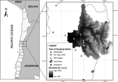
The Puclaro basin is an Andean basin located in the Coquimbo region of Chile () and has an area of 6582 km2 and elevation range of 487 to 6021 m a.s.l. The climate is semi-arid or steppe-type, with an annual average rainfall in Rivadavia at 820 m a.s.l. of 100 mm, concentrated between May and August (Khalthoff et al. Citation2002). The average monthly temperature ranges from 14.5°C in winter to 20.1°C in summer. Precipitation events occur mainly due to frontal systems brought predominantly by west and northwest winds (Khalthoff et al. Citation2002). shows the network of meteorological stations with data records of more than 30 years and occasional snow course measurements (snow depth and SWE). The Rivadavia station is used as the base station of this study due its large area and data quality. Of all 13 stations shown in , nine are pluviometric (raingauges with daily observations), and the others are meteorological stations that register: precipitation, temperature and relative humidity, every six hours. The rain instrumentation at these stations is mainly of the Hellman brand, with a measuring rod in the rain collector.
Fig. 1 General location of the Puclaro basin (left) and gauging stations with registers of more than 30 years (right) used in this study.
The main river in the Puclaro basin is the Elqui, which has a snowy hydrological regime and an annual medium inflow to the reservoir of 9.5 m3/s. This river reaches an average flow of 31.2 m3/s during the snowmelt period. The maximum instantaneous flow to the Puclaro Reservoir is 108 m3/s in winter, with a return period (T) of 10 years. The Puclaro basin has two reservoirs: the Puclaro Reservoir, which demarcates the studied basin with a capacity of 200 hm3, and La Laguna Reservoir of 15 hm3, located in the upper-east area. The spillway design capacities of the reservoirs are 2500 and 50 m3/s, respectively.
Historically, the most important floods have been caused by snowmelt; however, local studies (Ministerio de Energía Citation2011, CONAMA Citation2008) have shown that rain-caused floods will increase under A2 projections, due to temperature rises projected by the different GCM models for the basin demarcated by the Elqui station in Algarrobal (29.3 km upstream from the Puclaro Reservoir).
2.2 Spatial distribution of precipitation
In this study, we tried to correlate specific storms and total seasonal rainfall in rainy winters, including snow course observations, through geostatistical methods, such as inverse distance weighting (IDW), kriging and co-kriging, with elevation, orientation and slope, finding regular adjustments (not shown). These regular cross-correlations are required mainly because: (a) as the raingauge density at 933 km2/station is 3.7 times that recommended by WMO (Citation1994), we do not have enough stations to validate these spatial distributions; (b) as the majority of the observations are located across the valleys, the precipitation at higher elevations is not well-represented; and (c) the lack of snow stations did not allow us to determine the SWE at higher stations that are not capable of adequately measuring solid precipitation events. For all of these reasons, it was not possible to properly validate these kinds of spatial interpolation representation.
To obtain a better representation of the existing orographic effects in the region (Falvey and Garreaud Citation2007), WMO (Citation2009) suggest analysing a pattern of events associated with a specific return period, excluding summer events that could affect such a pattern.
The only existing pattern in the study region corresponds to DGA (Citation1995) that analyses spatially maximum-observed precipitation in 1, 2 and 3 days for a return period of T = 10 years. However, given the common presence of snow in wintertime and the lack of snowgauges at higher altitudes, this study was limited to low altitudes.
To solve the problem of appropriately representing the spatial distribution of precipitation, the behaviour of two patterns is assessed:
Case 1: The precipitation pattern defined by DGA (Citation1987), based on annual average floods and annual average rain between 1938 and 1987, considering summer events not to be significant with respect to winter events.
Case 2: A pattern given by the regional model PRECIS-DGF (DGF Citation2006) (resolution 25 km) applied to wintertime rainfalls related to a co-kriging interpolation, with a DEM spatially-aggregated to a 250 m × 250 m resolution.
For both cases, the pattern was validated as a function of the precipitation gradients and wintertime SWE observations from point snow course measurements for specific winters, in the preferred wind direction. Spatial distribution of precipitation through these patterns was conducted according to the Rivadavia station located in the lower part of the Puclaro basin, downstream from the system’s main rivers, as shown in .
2.3 Temporal distribution of precipitation
We temporally distributed precipitation at pluviometer stations by an adjustment according to the distance-power method (WMO Citation1969), at a time interval of 6 hours. The temporal disaggregation was conducted for the most severe storms registered in the zone, corresponding to events that occurred during July in 1984 and 1987, and August 1997, when the ENSO phenomenon was present (Schulz et al. Citation2011).
The temporal distribution of available records was analysed, and we found that there is a good correlation (not shown) with the theoretical Varas distribution, Group II (Citation1985), a study comparable to that conducted by Huff (Citation1967), where the higher intensity of the storm occurs during 25% and 50% of the total event duration time.
2.4 Estimation of the catchment contributing area
Because one of the aims of this study is to determine the PMF, it is necessary to define the most physically-favourable scenario for its occurrence, which happens when the contributing area is equal to the total area of the basin. However, the last assumption contradicts the reasonability criteria of the PMF definition (FEMA Citation1998), because the basin presents a large elevation range (5790 m) and a high average slope of 45%.
The problem of considering a reasonable catchment contributing area can be assessed with both a topographic and a hydro-meteorological approach.
The topographic approach aims to choose a high elevation in which a small altitude variation would not mean a considerable increase in the contributing rain area. In the case of the Puclaro basin, the chosen zero isotherm elevation (based on the hypsometry of the basin) corresponds to 4300 m a.s.l., the elevation at which 80% of the contributing area is located.
The hydrometeorological approach is based on temperature data records of the biggest daily storms of the last 33 years; the atmospheric lapse rate was computed for each event, determining a series of zero isotherm elevations. An elevation of 3700 m a.s.l. associated with T = 100 years was determined. The selection of this criterion is analogous to the considerations of WMO (Citation2009) for moisture maximization factors and the length of data record being smaller than 50 years.
2.5 PMP determination
There are several approaches for the estimation of the PMP, which vary according to data availability, climate type and the existence of an orographic effect. This study compares the PMP values obtained by statistical methods and hydro-meteorological approaches (WMO Citation2009).
2.5.1 Statistical estimation
The statistical methodology of the PMP formulated by Hershfield (Citation1961, Citation1965), together with the WMO (Citation2009) considerations, is used on a station scale. Seven gauging stations were considered in this estimation, all of which are located inside the basin () and have a dataset length longer than 30 years, as described in ; the mean annual rainfall () and standard deviation of the annual precipitation (
) are included for the seven stations.
Table 1 Weather stations near the Puclaro Reservoir (WGS 84 H19S).
2.5.2 Hydro-meteorological estimation based on the studied basin
The hydro-meteorological approach of PMP, based on the studied basin (hereafter HM1), maximizes observed storms through dynamic and moisture maximization factors, as follows:
The dynamic factor η is calculated according to equation (2) and indicates the storm’s efficiency where Win is the precipitable water over 1000 hPa inflowing to the basin. These values are obtained as a function of the estimated dew point temperature at the same pressure; P is the precipitation over the basin at a duration t. The subscript m indicates a return period of 100 years for the dynamic factor (ηm) and the precipitable water associated to the dew point temperature with the same return period (Win-m):
The daily dew point temperature (Td) was estimated from extreme records of relative humidity and daily temperatures (Tmax, Tmin, RHmax, RHmin) at the Rivadavia station, and real vapour pressure (ea), according to the Allen et al. (Citation1998) formulation. It is important to note that, because of the lack of hourly relative moisture data, we used the maximum daily dew point temperature in the storms instead of the persistent value over 12 h, as indicated in WMO (Citation2009). As the water content increases with the dew point temperature, Win-m and Win are expected to vary proportionately, and the moisture maximization factor is not expected to change significantly.
Assuming the existence of a saturated semi-adiabatic atmosphere and through traditional thermodynamic diagrams, it is possible to estimate the sea-level dew point temperature and, using the tables in WMO (Citation2009), the quantity of the precipitable water inflowing to the Puclaro Reservoir.
By replacing equation (2) in equation (1), we can note that this formulation maximizes the precipitable water of a return period of 100 years by the dynamic factor of the same frequency. This then turns the HM1 methodology into equation (3), since it is independent of the most severe precipitation, but dependent on the series of calculated historical dynamic factors:
The average precipitation over the basin included in the dynamic factor, in mixed regime basins, is influenced by the temperature, which is different for each precipitation event. In this study, in particular, liquid precipitation is assumed to be falling over the contributing area, and varies depending on the cases mentioned in Section 2.4.
2.5.3 Traditional hydro-meteorological method
The traditional approach for the estimation of PMP through hydro-meteorological methods (hereafter HM2) corresponds to the determination of DAD curves according to WMO (Citation1969) by amplifying the enveloping curve of the observed strongest storms by the moisture maximization factor and, in some cases, by a wind maximization factor. Since there are no extensive records of wind speed in the Puclaro basin, and given the complexity of the wind dynamics through the basin, obtaining an assumption of its spatial distribution is very complex. Therefore, this factor is not taken into consideration, which reduces the methodology to equation (4), where the maximization is determined only by the moisture factor, as explained in Section 2.5.2. As a consequence of this assumption, lower PMP estimations are obtained, as Fernando and Wickramasuriya (Citation2010) concluded.
Because the spatial distribution of the precipitation already includes the orographic effect, this method is applicable according to WMO (Citation2009) recommendations:
It is important to highlight that the boundaries of the catchment contributing areas are always given by the theoretical separation line between rain and snow that would change the DAD curves for each event (if it is only considered as liquid precipitation). This is because the maximum precipitation will be generally located at the highest elevation, due to the orographic effect. So, to remove this dynamic behaviour of the atmosphere, DAD curves are constructed to each zero isotherm, as described in Section 2.4.
2.5.4 Results assessment
To determine which method achieves the more realistic PMP estimation, the results obtained for each of the formulations listed above were compared with the precipitation associated with return periods of 1000 and 10 000 years estimated for the gauging stations, and with the enveloping curve determined for the specific strongest global storms registered (Wang et al. Citation2005), described by equation (5), where P is measured in mm and the duration, D, in hours:
In a similar way, the spatial PMP estimations are compared with the maximum registered precipitation in a given similar area for India, China, the USA and Australia (Rakhecha and Singh Citation2009). In these countries, severe storms mainly originate from tropical cyclones and typhoons; so, they allow us to set these greatest area rainfalls as an upper limit of the estimations determined for the study region that, originated by frontal systems in a semi-arid climate, should be much lower than the maximum precipitation events registered in those countries.
2.6 PMF determination
The inflowing PMF to the Puclaro Reservoir was determined through Snyder’s synthetic unit hydrograph (SUH), with the calibrated parameters for the study region according to MOP (Citation1998). Effective precipitation was determined using the Curve Number method (CN), according to MOP (Citation1994) considerations.
To establish the reliability of PMF estimations, they are compared with frequency analyses and confidence interval estimations of the floods caused by rainfall and snowmelt. Additionally, they are compared with the envelope flood of the severest instantaneous flows globally-registered in history, given by equation (6) (Wang et al. Citation2005), where Qm is the maximum instantaneous flow in m3/s and A is the total basin area in km2. Such a relationship is valid for basins with an area of 300–3 000 000 km2:
The rainfall–flood series analysed has a median and standard deviation of 17.1 and 13.3 m3/s, respectively; for snowmelt-caused floods, these values are 49.3 and 100.7 m3/s, respectively. A frequency analysis was performed using the χ2 test through several distributions, and the confidence interval estimation was done considering a classical Gaussian distribution, as described by Chow et al. (Citation1988).
2.7 Evaluation of the potential effects of climate change
The possible effects of climate change are evaluated both for the PMP (24 h) and for the PMF estimation. In the first case, the effects of the projections of maximum precipitation and of the hydro-meteorological factors that determine the PMP are analysed. Regarding the PMF, we also analysed the variations in temperature on storm days, as well as their effect on the basin contributing area and on the SUH parameters. In this way, we are able to achieve projections of PMF variability due to changes in the PMP and modifications in the SUH.
In the case of Hershfield’s PMP, a selection from the GCMs of the IPCC was made considering the ones most similar to the NCEP/NCAR re-analysis (Kalnay et al. Citation1996), in terms of annual daily maximum precipitation. This was done in an attempt to reduce the uncertainty that arises from the great variability that exists between the precipitation tendencies projected (Rousteenoja et al. Citation2003, IPCC Citation2007).
The last assertion is supported by the principle that we must assume that a simulation that accurately reproduces observed climatology does so because it is realistically simulating the actual causal physics involved (Pierce Citation2004); so, if a GCM does not accurately reproduce the local climatology, it is probably not capable of reproducing the real atmospheric processes. For this reason, we prefer not to work with them for future projections.
For hydro-meteorological methods of PMP estimation, only the ECHAM5 model is analysed, because it best reproduces the historical climatology of the central area of Chile in terms of both seasonality and magnitude of precipitation events (not shown). These projections are the ones considered in the evaluation of the variations of the inflowing SUH of the Puclaro Reservoir, and in the factors and meteorological variables that determine the PMP estimated by hydro-meteorological criteria.
Quantifications for possible PMP variations were made according to a statistical downscaling process adapted from the bias correction-spatial disaggregation method (Wood et al. Citation2004). This method basically consists of disaggregating the GCM to a gauging station scale through an interpolation process, and then correcting the biases between the duration curves of the spatially-downscaled series and the local observations.
Downscaling was applied to the series of annual daily maximum precipitation, dew point temperatures and daily average temperatures interpolated from the GCM to each gauging station in the baseline period (BL: 1960–1999), and A2 and B1 (2045–2065) scenarios. The projected climate changes during the 2045–2065 period (A2 and B1 scenarios) were quantified and compared with the historical scenario BL.
We worked with specific moisture projections by the ECHAM5 GCM model in order to assess possible changes in the PMP determined by the HM1 and HM2 methods. This enabled us to indirectly obtain the dew point temperature and, therefore, the precipitable water over an atmospheric column using the same methodology as explained in Section 2.5.2.
2.8 Uncertainty analysis
Since the hydrometeorological estimation of PMP involves statistical uncertainties in the determination of each maximization factor, a confidence interval of 95% was determined for each one, computing their implications in the corresponding PMP estimations.
Possible PMF values are also presented, considering the different Varas probabilistic distributions (Citation1985, Group II), the previous soil moisture conditions according to the CN method and, when it applies, the uncertainty of the PMP estimations related to the 95% confidence interval in the maximization factors.
3 RESULTS
3.1 Spatial representation of the precipitation
and show the orographic pattern obtained according to the PRECIS-DGF model (DGF Citation2006) and the annual isohyets (DGA Citation1987), respectively. In both cases, a rise in the precipitation pattern from the northwest can be seen that corresponds to the predominant direction of the wind during wintertime (Khalthoff et al. Citation2002). This represents the orographic tendencies of precipitation as described by Falvey and Garreaud (Citation2007).
Fig. 2 Annual maximum daily precipitation pattern. Ratio between the average wintertime precipitation level given by the PRECIS-DGF model and the one registered at the Rivadavia station.
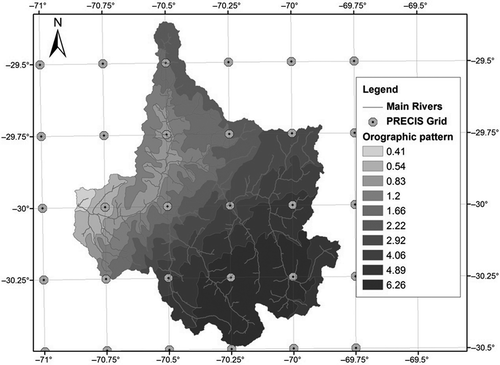
Fig. 3 Annual maximum daily precipitation. Ratio between the average annual precipitation given by DGA (Citation1987) and the one registered at the Rivadavia station.
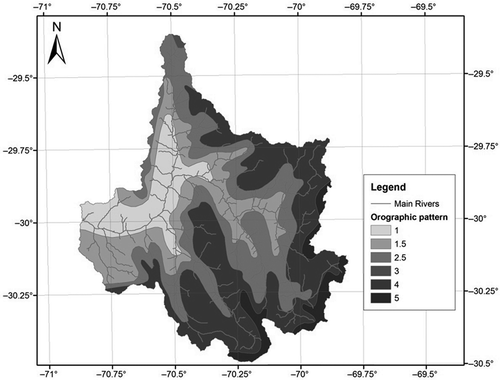
The aforementioned patterns were compared and corrected according to the SWE (not shown) and precipitation records following the considerations presented in Section 2.2. We found that the pattern obtained according to the DGA (Citation1987) study correlates better with the observations and seems very similar to the maximum precipitation amounts in the basin. Because of this, future precipitation projections were conducted using this criterion.
3.2 PMP estimations in BL
shows the average spatial precipitation for PMP and events of 1000- and 10 000-year return periods, together with the average precipitation on the contributing areas described in Section 2.4 (topographic and hydro-meteorological criteria), corrected by the orographic patterns.
Table 2 Daily PMP and maximum precipitation (mm) associated with T = 1000 and 10 000 years in the Puclaro basin.
The enveloping precipitation, according to Wang et al. (Citation2005), for a duration of 24 h, is 2065 mm. However, the most severe storms registered in India, China, the USA and Australia, for an area equal to the total Puclaro basin, are 1132, 590, 490 and 528 mm, respectively (Rakhecha and Singh Citation2009).
Comparing the results presented in and the several storms listed above, given the predominant semi-arid climatology of the study area, the method chosen for the determination of the catchment contributing area is the hydro-meteorological approach, not the topographic method.
In the same manner, the HM1 and HM2 methods were chosen as the most realistic estimation of PMP, instead of a statistical approach, due the studied area’s climatic characteristics.
3.3 PMP estimations in scenarios A2 and B1 (2045–2065)
Considering the 10 GCMs previously selected through the NCEP/NCAR criterion described in Section 2.7, shows the percentages of the statistical PMP variations for each gauging station, listed in , for scenarios A2 and B1.
Fig. 4 Percentages of variation relative to the BL scenario for the PMP according to the Hershfield method under scenarios A2 (left) and B1 (right).
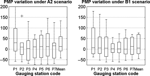
The statistical PMP variations projected for each scenario present large variability, which reflects itself in an increase in the median of +11.9% and +4.9% for scenarios A2 and B1, respectively. The first and third quartile projections show variations of, respectively, −9.0% and +58.9% for Scenario A2, and of −21.4% and +68.9% for Scenario B1.
shows the projections of the ECHAM5 model of the series of annual maximum daily precipitation and the corresponding daily average temperature. A clear rise in the average temperature on rainy days can be observed at a median of +2.6 and +1.7°C for scenarios A2 and B1, respectively; however, the B1 scenario projects less variability.
Fig. 5 ECHAM5 model projections of the median temperature in rainfall events (left) and annual maximum daily precipitation level (right) under scenarios BL, A2 and B1 for the Puclaro Reservoir basin.
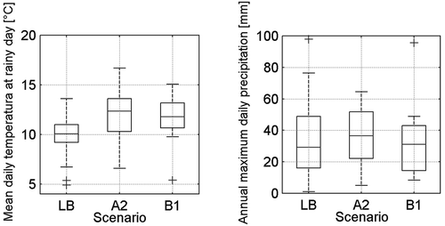
In the case of the series of annual maximum daily precipitation, a smaller variability is projected for both A2 and B1 scenarios, with A2 being slightly higher. Furthermore, a rise in the median of precipitation of 25% is expected for scenario A2, whereas the variation for the B1 scenario is only 7% in relation to the BL median.
When considering a wet adiabatic gradient of −5.55°C/km, i.e. the average estimated in the BL period, the rise in temperature on rainy days would generate an elevation of the zero isotherm to 4260 and 4080 m a.s.l. for scenarios A2 and B1, respectively, with a return period of 100 years.
In terms of the average precipitation level in the basin, although the ECHAM5 model projects negative variations in the annual maximum daily precipitation, due to the catchment contributing area increase, the average liquid precipitation would be expected to rise in the basin due to the strong influence of the orography.
The factors that determine the PMP according to the HM1 method and equation (3) project an increase of +48.1% and +59.5% for the dynamic factor and variations of +10% and −7.1% for the atmospheric moisture maximization factor in scenarios A2 and B1, respectively; this is due mainly to the projected increase in the temperature for precipitation events.
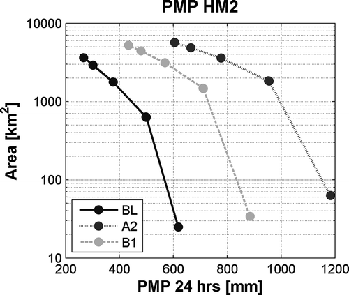
shows the variations of the DAD curves of the 24-h PMP HM2, where a generalized increase for both scenarios can be observed; it is smaller in scenario B1, however, due to the rise in temperature and the effects previously described.
Fig. 6 PMP curves of 24-h duration for maximization according to the atmospheric moisture factor under scenarios BL, A2 and B1 for the Puclaro Reservoir basin.
summarizes the PMP estimations according to the Hershfield method and the HM1 and HM2 methods in the Puclaro basin, for conditions of climate change in scenarios A2 and B1, as well as their rises relative to the BL period.
Table 3 PMP estimations using the A2 and B1 scenarios (2045–2065) for Puclaro basin.
3.4 PMF estimations
shows the PMF estimated by different methods in the historical BL period in comparison to frequency analysis of floods in wintertime and snowmelt periods, with their respective confidence interval (95%). The flood obtained by the enveloping curve of equation (6) (Wang et al. Citation2005), which corresponds to 29 448 m3/s, is also shown in , and we can see that the events with a return period of 10 000 years, caused both by rainfall and snowmelt, are not bigger than the PMF values. However, the PMF projected by the HM2 method is included in the confidence interval associated with the snowmelt-caused floods of T = 2500 years. The PMF projected by the HM1 method is included in the confidence level of snowmelt-caused floods with a 5500-year return period.
Fig. 7 PMF estimations and frequency analysis of the historical floods due to rainfall in the Puclaro Reservoir basin.
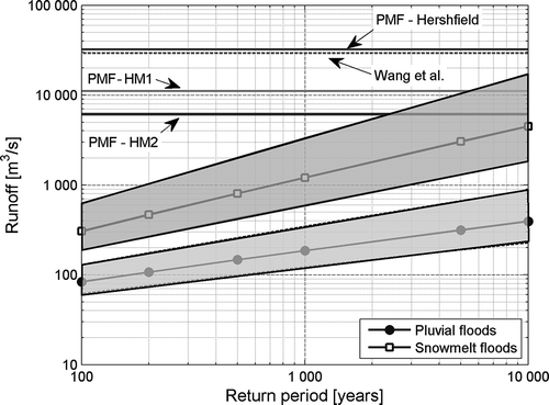
Since the Hershfield methodology produces bigger floods than the historical floods’ enveloping curve (Wang et al. Citation2005), which were registered in much wetter climate basins, it is not considered to be a very realistic approach.
With both the statistical and hydro-meteorological approaches, the PMF demonstrates significant rises in the maximum instantaneous floods and the direct runoff volume, shown in , where variations for the PMF obtained according Hershfield’s PMP are also included.
Table 4 Differences relative to the BL period in PMF estimation under normal previous moisture conditions in the Puclaro Reservoir basin.
3.5 Analysis of the statistical uncertainty of the results
shows the range of possible PMP values that could be obtained in each scenario, when 95% confidence intervals of the factors of maximization in the hydro-meteorological methods employed are incorporated. The variation range is 127, 429 and 333 mm for the HM1 method in scenarios BL, A2 and B1, respectively. These uncertainties increase in future scenarios due to the decrease in the number of statistical data and the climate change projections, being especially greater in scenario A2.
Fig. 8 Range of variation of the median 24-h PMP values over the catchment contributing area of the Puclaro Reservoir for an isotherm elevation of 0°C, with a 100-year return period, under scenarios BL, A2 and B1.
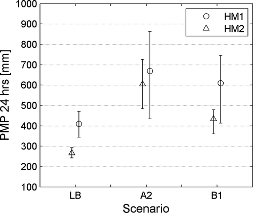
The PMP obtained with the HM2 method presents variation intervals of 49, 242 and 120 mm in scenarios BL, A2 and B1, respectively. These ranges are smaller than those presented in the HM1 method because it only includes the (same) moisture maximization factor.
Regarding the PMF, shows the variation range of the maximum instantaneous flows of the PMF that includes variations in the previous moisture conditions, the probability of exceedence of the temporal distribution of rainfall according to Varas (Citation1985, Group II) distributions, and the variation ranges of the PMP estimations according to the HM1 and HM2 methods (95%).
Fig. 9 PMF maximum instantaneous flow variation according to the HM1 (left) and HM2 (right) methods in the Puclaro Reservoir basin.
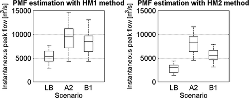
also indicates that higher variability can be found in scenario A2 for both methods, and that an even higher variability is obtained with the HM1 method in each scenario given the statistical uncertainty induced by the double-maximization factors used. This variation range reaches a maximum of 20 710 m3/s under scenario A2, causing maximum instantaneous flows similar to the threshold value given by Wang et al. (Citation2005); this is much higher than those in the BL, where this range is 9949 m3/s.
4 DISCUSSION
The spatial representation of the meteorological variables in sparsely-gauged basins presents a strong limitation to these types of study. The lack of stations located in higher areas and distributed around the streams does not properly represent the spatial behaviour of the storms. Additionally, in many cases, those located at higher altitudes could have their records altered because of the snow. Consequently, the use of regional climate models would be a quite potent tool for obtaining these patterns; however, when comparing the current estimations with those obtained from observations (DGA Citation1987) in , it is possible to appreciate a large overestimation by the PRECIS-DGF model in higher areas, as concluded in DGF (Citation2006).
When comparing the PRECIS patterns to those obtained by observations (DGA Citation1987) of wintertime gradients generated in frontal systems from the northwest, including snow course measurements for particular events, it can be concluded that the orographic pattern obtained by the observed data (DGA Citation1987) more faithfully represents the spatial variability of the precipitation, at least in the better-controlled sub-basin for the predominant wind direction (NW).
In the determination of the catchment contributing area, we can conclude from the results in that a meteorological perspective is more appropriate than topographic criteria, because few realistic areal PMP values were obtained with the latter when compared with precipitation of return periods of 1000 and 10 000 years, and with precipitation over equal areas as recorded in India, the USA, China and Australia (Rakhecha and Singh Citation2009).
With respect to the hydro-meteorological methods, we can conclude:
The HM1 method corresponds to a statistical method that multiplies the duration of the storm, the atmospheric moisture over a basin and the dynamic factor, all of which are associated with a return period of 100 years (equation (3)). This method seems to have less subjectivity than others and only varies its calculation according to the extent of the meteorological records.
The HM2 method focuses on the study of specific storms, using a DAD behaviour pattern that presents major subjectivity in their selection.
Taking into consideration the determination of the catchment contributing area in mixed regime basins (that will lead to constructing new DAD relationships for each event), we propose the use of a contributing area given by the zero isotherm elevation with a return period of 100 years, resulting in safer designs.
indicates that the HM2 method gives PMP values 35% smaller than the HM1 method for the BL period; this could change if we also included the amplification by a wind factor in order to evaluate more possibilities, as proposed by Fernando and Wickramasuriya (Citation2010). These authors conclude that the double-maximized HM2 method is similar to Hershfield’s PMP estimation. The lack of distributed and extensive wind speed measures, as well as the complexity of its flow in the basin (being intercepted by several mountain barriers), makes it difficult to properly calculate estimations for this factor in the study area. This prevents us from applying theoretical models of laminar flow for mountain barriers (WMO Citation2009), a method only applicable to the sub-basin located in the southwest of the Puclaro basin.
As a response to Papalexiou and Koutsoyiannis’ (Citation2006) questioning of the theoretical upper limit of precipitation, we assert that climate change projections will change this limit. Going beyond challenging the existence of PMP, we suggest quantifying climate change projections in its determination so as to obtain safer dam designs.
The PMF estimations in the BL are significantly higher than rain-caused floods and are included in the confidence interval of snowmelt-caused floods for return periods of T = 2500 years, owing to their great variation (). We can conclude from that, as the Hershfield’s PMP estimation generates greater floods than the severest instantaneous enveloping floods (Wang et al. Citation2005), it is better to leave this methodology aside for the study area.
The PMP/PMF verification with envelope curves of worldwide historical events allowed us to compare our results with events registered in much more adverse climatic conditions. While enveloping extreme events can be associated with an exceedence probability for local climatic conditions (Castellarin et al. Citation2009), a worldwide enveloping curve serves as an indicator of plausible extreme events, and so we can make them comparable to PMP/PMF calculation, as the last author concluded.
Future projections in scenarios A2 and B1 present great variability in the Hershfield PMP analysis in . This variability concurs with Rousteenoja et al.’s (Citation2003) projections; in the same way, we notice a statistical rise in the average precipitation that concurs with the regional results obtained by Kharin et al. (Citation2007) for precipitation with a return period of 20 years. This increase is theoretically possible because of the rises in temperature that make the precipitable water content increase (Sugiyama et al. Citation2010), according to the ECHAM5 model analysed.
Temperature projections of the ECHAM5 model for rainy days are very similar to the projections of 15 GCMs downscaled by Maurer et al. (Citation2007) in winter months for both the A2 and B1 scenarios. In a similar way, when comparing the historical analysis of temperatures by Rosenblüth et al. (Citation1997), who found a heating of +2.8°C/century in the annual average temperature, the studied projections are still reasonable.
Statistically speaking, the employed downscaling process should be used with caution, as the statistical relationships used to bias-correct the BL scenario do not necessarily have to be the same for future time periods; however, the GCM’s downscaled outputs should not be treated as observations. Instead, we should look at them by focusing on the projected changes, as Prudhomme et al. (Citation2002) suggested, due to the quality of the current state-of-the-art for the models.
Regarding the PMF, a rise in the maximum instantaneous flow for the HM1 method is projected of +72.7% and +75.9% for scenarios A2 and B1, respectively, while in the HM2 method variations of +174.5% and +84.8%, respectively, can be projected. In both methods and scenarios, we can also see the effect of the temperature rise through runoff volume, as shown in .
The analysis presented here enables the assessment of the effects of potential projected floods and conceptually resembles the results of local studies for the Elqui River basin at Algarrobal (Ministerio de Energía Citation2011, CONAMA Citation2008) that exhibited a change in its hydrological regime.
The use of the SUH allowed us to evaluate climate change projections; however, the use of other hydrological models that include the physics involved in the hydrological cycle, as well as the spatial distribution of meteorological data and the snowmelt processes, would greatly improve the more relevant and sensitive variables that determine how rainfall causes floods in snowy regime basins.
To apply more sophisticated distributed models in the evaluation of water resources due to climate change (e.g. Maurer Citation2007), the spatial representation of meteorological variables must be enhanced by improving gauging stations to include snow stations, use of radars, and the validation and testing of other RCM and re-analyses.
Uncertainties in PMP estimation can introduce large ranges in the BL of up to 127 and 42 mm under scenarios A2 and B2, respectively, which represents a great variation for areas where the annual precipitation level reaches 100 mm. Regarding the PMF, the variation ranges of the maximum instantaneous flow are 9950 and 20 710 m3/s under scenarios BL and A2, respectively, results that are equally important and reach the Wang et al. (Citation2005) limit threshold; so, the concept itself of a risk-free design has shown to be incorrect because of large uncertainties of scale. The previous uncertainties are mainly associated with: the confidence interval of the maximization factors of PMP HM1 and HM2, temporal distributions of rainfall and previous humidity of the basin. Other factors that were not computed, such as spatial distribution of the precipitation, contribution of snowmelt, etc., would also have led to different PMF estimations.
These potential variations in the estimations of the maximum of potential events and possible climate projections must be considered by decision makers in order to ensure an appropriate hydrological design, given the long time period considered in the conception of huge hydraulic works, as well as potential climate change effects in the areas studied (Dörte et al. Citation2009).
5 CONCLUSIONS
The existence of a pattern of spatial precipitation allows the application of different hydro-meteorological approaches for estimating PMP in sparsely-gauged basins (WMO Citation2009), with a previous validation with observations of precipitation and snow courses (if applicable), at least for the predominant wind direction in the rainfall period.
In mixed hydrological regime basins with rough topography, as in the studied region, the catchment contributing area for the probable maximum flood determination should be obtained through a hydro-meteorological criterion that considers the statistics of temperatures or the snow data (regarding the situation), rather than a topographic or an average snow-line elevation, in order to avoid over- or under-estimation. It is proposed that, in the case of the existence of temperature data, an isotherm zero elevation should be employed with a return period of 100 years.
Climate change projections in the study area show an average increase in probable maximum precipitation and probable maximum flood. This rise would be mainly caused by an increase in temperatures during rainy days and its effects on the precipitable atmospheric water content and in the augmentation of the catchment contributing area. Such effects depend mostly on the particular topography of each basin and can be extended to other regions having similar hydrological regimes and geomorphologic characteristics.
The sources of uncertainty quantification, as well as the potential effects of climate change, will deliver a large range of possible probable maximum floods and low frequency floods, which should be considered by decision-makers in the design of major hydraulic works, given their long lifetime.
Acknowledgements
The authors acknowledge the water and climatological Chilean authorities, Dirección General de Aguas and Dirección Meteorológica de Chile, for generously providing the meteorological data used in this paper. We are also very grateful for the valuable commentary and corrections from the anonymous reviewer.
REFERENCES
- Allen, R.G., et al., 1998. Crop evapotranspiration-Guidelines for computing crop water requirements. FAO Irrigation and drainage paper 56. FAO, Rome 300, 6541
- Benson, M.A., 1973. Thoughts on the design of design floods. In: Floods and droughts. Proceedings of 2nd international symposium in hydrology, 11–13 September 1972. Fort Collins, CO: Water Resources Publications, 27–33. Available from: http://tocs.ulb.tu-darmstadt.de/183863208.pdf
- Buytaert W., et al., 2006. Spatial and temporal rainfall variability in mountainous areas: a case study from the South Ecuatorian Andes. Journal of Hydrology. doi:10.1016/j.jhydrol.2006.02.031
- Carrasco, J., Osorio, R., and Casassa, G., 2008. Secular trend of the equilibrium-line altitude on the western side of the southern Andes, derived from radiosonde and surface observations. Journal of Glaciology, 54, 538–550. doi:10.3189/002214308785837002
- Casale, R., Bronstert, A., and Samuels, P., 1999. Impact of climate change on flooding and sustainable river management. In: Proceedings of the 2. International RIBAMOD Workshop, 26–27 February 1998 Wallingford. Luxemburg: European Commission, DG XII, Environment and Climate Programme; Office for Official Publications of the European Communities.
- Cassasa, G., 1995. Glacier inventory in Chile: current status and recent glacier variations. Annals of Glaciology, 21, 317–322.
- Castellarin, A., Merz, R., and Blöschl, G., 2009. Probabilistic envelope curves for extreme rainfall events. Journal of Hydrology, 378 (3–4), 263–271. doi:10.1016/j.jhydrol.2009.09.030
- Cheng, F.-W. and Liu, C.-W., 2012. Estimation of spatial rainfall distribution using inverse distance weighting (IDW) in the middle of Taiwan. Paddy and Water Environmental, Springer. doi:10.1007/s10333-012-0319–1
- Chow, V.T., et al., 1988. Applied hydrology. McGraw-Hill Series in Water Resources and Environmental Engineering. New York, NY: McGraw-Hill, xiii, 572 pp. ISBN 0-07-010810-2.
- CONAMA (Comisión Nacional del Medio Ambiente). 2008. Análisis de la vulnerabilidad del sector silvoagropecuario, recursos hídricos y edáficos de Chile frente a escenarios de cambio climático. Santiago: AGRIMED Universidad de Chile.
- Cortés, G., et al., 2010. Comparison of modelling approaches in assessing hydrologic processes in a high elevation, semi-arid Andean watershed. American Geophysical Union, Fall Meeting, 2010, abstract #H41F–1145.
- Daly, C., Neilson, R.P., and Phillips, D., 1994. A statistical-topographic model for mapping climatological precipitation over mountainous terrain. Journal of Applied Meteorology, 33, 140–158. doi:10.1175/1520-0450(1994)033<0140:ASTMFM>2.0.CO;2
- Departamento de Geofísica (DGF) Universidad de Chile. 2006. Estudio de Variabilidad Climática en Chile para el Siglo XXI. CONAMA.
- Dirección General de Aguas (DGA), 1987. Balance Hídrico de Chile. Gobierno de Chile: Ministerio de Obras Públicas.
- Dirección General de Aguas (DGA), 1995. Precipitaciones Máximas en 1, 2 y 3 días. República de Chile: Ministerio de Obras Públicas.
- Dörte J., et al., 2009. Climate change and Probable Maximum Precipitation. HRS No. 12. Australian Government Bureau of Meteorology. Hydrometeorological Advisory Service, Water Division, Melbourne.
- Falvey, M. and Garreaud, R., 2007. Wintertime precipitation episodes in Central Chile: associated meteorological conditions and orographic influences. Journal of Hydrometeorology, 8, 171–193. doi:10.1175/JHM562.1
- FEMA, 1998. Federal Emergency Management Agency, Mitigation Directorate, Integracy Committee on Dam Safety, October 1998. Federal Guidelines for Dam Safety: Selecting and Accommodating Inflow Design Floods for Dams, FEMA 94.
- Fernando, W.C.D.K. and Wickramasuriya, S., 2010. The hydrometeorological estimation of probable maximum precipitation under varying scenarios in Sri Lanka. International Journal of Climatology, 31 (5), 668–676. doi:10.1002/joc.2096
- Graham, W.J., 2000. Should dams be modified for the probable maximum flood? Journal of the American Water Resources Association, 36 (5), 953–963. doi:10.1111/j.1752-1688.2000.tb05701.x
- Hershfield, D.M., 1961. Estimating the probable maximum precipitation. Jorunal of the Proceedings of the American Society of Civil Engineers, 87 (HY5), 99–106.
- Hershfield, D.M., 1965. Method for estimating probable maximum rainfall. Journal of the American Water Works Association, 57, 965–972.
- Huff, F.A., 1967. Time distribution of rainfall in heavy storms. Water Resources Research, 3 (4), 1007–1019. doi:10.1029/WR003i004p01007
- IPCC (Intergovernmental Panel on Climate Change), 2007. Climate change: the physical science basis. Contribution of Working Group I to the Fourth Assessment Report of the Intergovernmental Panel on Climate Change. S. Solomon, D. Qin, M. Manning, Z. Chen, M. Marquis, K.B. Averyt, M. Tignor and H.L. Miller eds. Cambridge, UK: Cambridge University Press.
- Kanamitsu, K.M., et al., 1996. The NCEP/NCAR 40-year reanalysis project. Bulletin of the American Meteorological Society, 77 (3), 437–471. doi:10.1175/1520-0477(1996)077<0437:TNYRP>2.0.CO;2
- Khalthoff, N., et al., 2002. Mesoscale wind regimes in Chile at 30°S. American Meteorological Society, 41, 953–970.
- Kharin, V.V., et al., 2007. Changes in temperature and precipitation extremes in the IPCC ensemble of global coupled model simulations. Journal of Climate, 20, 1419–1444. doi:10.1175/JCLI4066.1
- Koutsoyiannis, D., 1999. A probabilistic view of Hershfield’s method for estimating probable maximum precipitation. Water Resources Research, 35 (4), 1313–1322. doi:10.1029/1999WR900002
- Maurer, E., 2007. Uncertainty in hydrologic impacts of climate change in the Sierra Nevada, California, under two emissions scenarios. Climatic Change, 82, 309–325. doi:10.1007/s10584-006-9180–9
- Maurer, E., et al., 2007. Fine-resolution climate projections enhance regional climate change impact studies. Eos Transactions AGU, 88 (47), 504. doi:10.1029/2007EO470006
- Ministerio de Energía, 2011. Selección y aplicación de un modelo hidrológico para estimar los impactos del cambio climático en la generación de energía del sistema interconectado central. Santiago: Departamento de Ingeniería Civil, División Recursos Hídricos y Medio Ambiente, Universidad de Chile.
- MOP (Ministerio de Obras Públicas), República de Chile. 1994. Proyecto Embalse Puclaro, vol. VII. Santiago: Consorcio de Ingeniería INGENDESA-EDIC Ltda.
- MOP (Ministerio de Obras Públicas), República de Chile. 1998. Manual de cálculo de crecidas y caudales mínimos en cuencas sin información fluviométrica. Santiago: Dirección General de Aguas, 151 p.
- National Research Council, 1994. Estimating bounds on extreme precipitation events. Washington: National Academy Press.
- Noguchi, M., Tahat, H., and Hanada, H., 1994. The effects of space averaging on rainfall–runoff analysis. Reports of the Faculty of Engineering, Nagasaki University, 24 (43). Available from: http://hdl.handle.net/10069/24451. [Accessed September 2011].
- Papalexiou, S.M. and Koutsoyiannis, D., 2006. A probabilistic approach to the concept of Probable Maximum Precipitation. Advances in Geosciences, 7, 51–54. doi:10.5194/adgeo-7-51-2006
- Pierce, D.W., 2004. Beyond the means: validating climate models with higher-order statistics. Computing in Science & Engineering, 6 (5), 22. doi:10.1109/MCSE.2004.32
- Prudhomme, C., Reynard, N., and Crooks, S., 2002. Downscaling of global climate models for flood frequency analysis: where are we now? Hydrological Processes, 16, 1137–1150. doi:10.1002/hyp.1054
- Rajeevan, M., et al., 2005. Development of a high resolution daily gridded rainfall data for the Indian region. Government of India. Met. Monograph Climatology No. 22.
- Rakhecha, P.R. and Singh, V.P., 2009. Applied hydrometeorology. Springer. ISBN: 978-1-4020-9843-7 (Print) 978-1-4020-9844-4 (Online).
- Rosenblüth, B., Fuenzalida, H., and Aceituno, P., 1997. Recent temperature variations in southern South America. International Journal of Climatology, 17, 67–85. doi:10.1002/(SICI)1097-0088(199701)17:1<67::AID-JOC120>3.0.CO;2-G
- Rousteenoja, K., et al., 2003. Future climate in world regions: an intercomparison of model-based projections for the new IPCC emissions scenarios. The Finnish Environment 644, Finnish Environment Institute, Helsinki.
- Saha, S., et al., 2010. The NCEP climate forecast system reanalysis. Bulletin of the American Meteorological Society, 91, 1012–1057. doi:10.1175/2010BAMS3001.1 Available from: http://journals.ametsoc.org/doi/pdf/10.1175/2010BAMS3001.1.
- Schulz, N., Boisierb, J.P., and Aceituno, P., 2011. Climate change along the arid coast of northern Chile. International Journal of Climatology [online] doi:10.1002/joc.2395
- Sen, Z. and Habib, Z., 2001. Monthly spatial rainfall correlation functions and interpretations for Turkey. Hydrological Sciences Journal, 46 (4), 525–535. doi:10.1080/02626660109492848
- Sugiyama, M., Shiogama, S., and Emori, S., 2010. Precipitation extreme changes exceeding moisture content increases in MIROC and IPCC climate models. Proceedings of the National Academy of Sciences, 107 (2), 571–575. doi:10.1073/pnas.0903186107
- Teegavarapu, R., Tuffail, M., and Ormsbee, L., 2006. Optimal function forms for spatial interpolation of precipitation data. Environmental Informatics Archives, 4, 343–353.
- Vanrheenen, N., et al., 2004. Potential implications of PCM climate change scenarios for Sacramento-San Joaquin river basin hydrology and water resources. Climatic Change, 62, 257–281. Kluwer Academic Publishers. doi:10.1023/B:CLIM.0000013686.97342.55
- Varas, E., 1985. Hietogramas de Tormentas de Diseño. VII Congreso Nacional de Ingeniería Hidráulica, SOCHID, Concepción, Chile.
- Viale, M., 2010. Características de las precipitaciones orográficas de invierno sobre los Andes subtropicales centrales. Tesis para optar al título de Doctor de la Universidad de Buenos Aires en el área de Ciencias de la Atmósfera y los Océanos.
- Wang, G., 1999. Principles and methods of PMP/PMF calculations. Beijing: China Water Power Press and Yellow River Water Resources Publishing House.
- Wang, G., Li, B., and Wang, J., 2005. World’s greatest known point rainfalls and their enveloping curve formula. Also published 2006. Advances in Water Science, 17 (6), 831–836.
- Wood, A., et al., 2004. Hydrologic implications of dynamical and statistical approaches to downscaling climate model outputs. Climatic Change, 189–216. doi:10.1023/B:CLIM.0000013685.99609.9e
- WMO (World Meteorological Organization). 1969. Manual for Depth–Area–Duration analysis of storm precipitation. WMO-No. 237. TP 129, Geneva.
- WMO (World Meteorological Organization). 1994. Guide to hydrological practices. WMO-No. 168. Geneva.
- WMO (World Meteorological Organization). 2009. Manual for estimation of Probable Maximum Precipitation (PMP). WMO-No. 1045. Geneva.