
ABSTRACT
The inland extending length of the freshwater–saltwater interface toe is useful in studies of seawater intrusion in coastal areas. The submarine fresh groundwater discharge in coastal zones is affected not only by hydraulic conductivity and hydraulic gradient of the aquifer, but also by the position of the interface. Two observation wells at different distances from the coast are required to calculate the fresh groundwater flow rate in coastal unconfined aquifers. By considering that the submarine groundwater discharge is equal to the groundwater flow rate, the length of the interface toe extending inland can be estimated when the groundwater flow is at a steady-flow state. Aquifers with horizontal and sloping confined beds and without/with unique surface vertical infiltration are considered. Examples used to illustrate the application of these methods indicate that the inland extending lengths of the interface toe in aquifers with vertical surface infiltration are much shorter than those in aquifers without vertical surface infiltration, and the length of the interface in aquifers with a horizontal confining lower bed are smaller than those in aquifers with a confining lower bed sloping towards the sea. The extent of the interface on the northwestern coast near the city of Beihai in southern Guangxi, China, on 18 January 2013 was estimated as 471–478 m.
Editor M.C. Acreman Associate editor not assigned
Introduction
Seawater intrusion has been the focus of a number of studies related to coastal hydrogeology (e.g. Bear Citation1979, Kashef Citation1986, Cheng and Ouazar Citation1999, Zhou et al. Citation2000, Rajmohan et al. Citation2009, Park et al. Citation2012, Trabelsi et al. Citation2012, Elewa et al. Citation2013). Understanding of the length of the freshwater–saltwater interface extending into coastal aquifers is important in the investigation of the groundwater environment in these areas, especially in the study of prevention of seawater intrusion in coastal zones. Under natural conditions fresh groundwater in coastal zones commonly discharges into the sea. The submarine fresh groundwater discharge in coastal zones is controlled not only by the hydraulic conductivity of the aquifer and the difference in hydraulic heads between the fresh groundwater and the sea, but also by the position of the freshwater–saltwater interface (Bear Citation1972, Citation1979, Rushton Citation1980, Zhou et al. Citation2010). Attention has been paid to mathematical models related to freshwater–saltwater interfaces by numerous researchers (Strack Citation1976, Citation1989, Van der Veer Citation1977, Reilly and Goodman Citation1985, Essaid Citation1986, Isaacs and Hunt Citation1986, Singh and Stammers Citation1989, Ledoux et al. Citation1990, Dagan and Zeitoun Citation1998, Person et al. Citation1998, Maas Citation2007, Xun et al. Citation2008, Zhou Citation2011, Lu et al. Citation2015). Submarine fresh groundwater discharge in both unconfined aquifers and confined aquifers was examined by Bear (Citation1979), Cheng and Ouazar (Citation1999) and Bear et al. (Citation1999). Some researchers (e.g. Robinson et al. Citation2007, Tang et al. Citation2007) examined the location of the interface that is affected by the tide. Other researchers (e.g. Urish and McKenna Citation2004, Robinson et al. Citation2007) analysed groundwater discharge into the sea in a coastal zone that is affected by the tide. Studies of the freshwater–saltwater interface related to submarine groundwater discharge were made by a number of researchers (Kashef Citation1986, Izuka and Gingerich Citation1998, Kim et al. Citation2007, Maas Citation2007, Xun et al. Citation2008, Xun and Ying Citation2009, Zhou Citation2011). Knowledge of the length of the freshwater–saltwater interface toe extending inland is commonly necessary information in the investigation of seawater intrusion in coastal areas. Based on the Ghyben-Herzberg relation, Domenico and Schwartz (Citation1990) presented a simple model to determine the length of saltwater wedge in a coastal unconfined aquifer where the location of the interface toe is known. Zhou (Citation2014) described the methods for estimating the interface extending into coastal confined aquifers with horizontal and sloping confining beds where the location of the interface toe is not known in advance. The purpose of the this paper is to provide methods of estimating the length of the freshwater–saltwater interface extending into inland unconfined aquifers where the location of the interface toe is not known a priori. Unconfined aquifers with horizontal and sloping lower confining beds and without/with unique vertical surface infiltration are examined. Examples are also given to illustrate the application of the methods for estimating the inland extending length of the freshwater–saltwater interface in coastal unconfined aquifers. The extending distance of the interface in the northwestern coast of Beihai in southern Guangxi, China, is calculated as an actual example. These methods are simple and suitable for regional hydrogeological studies in coastal regions.
Submarine fresh groundwater discharge in a coastal unconfined aquifer
To estimate the length of the freshwater–saltwater interface extending into inland unconfined aquifers, the submarine fresh groundwater discharge into the sea in the coastal zone must be described first.
shows a profile perpendicular to the coastline in a homogeneous and isotropic coastal unconfined aquifer with unique vertical infiltration on the land surface. It is assumed that fresh groundwater flow is in a steady state and discharges into the sea, and a seepage face near the coast does not exist. The flow rate in the salt-water zone is assumed too small in comparison with that in the freshwater zone and can be neglected. A possible capillary zone above the phreatic surface is also neglected (Strack Citation1976). An observation well is located at a distance L from the coastline. The water table at the observation well is denoted hL. One needs to estimate the steady discharge of fresh groundwater into the sea and determine the location of the freshwater–saltwater interface. Bear (Citation1979) examined the groundwater flow in the coastal unconfined aquifer and provided the solution for the steady discharge of fresh groundwater into the sea by placing the x axis along the aquifer base with the origin at the interface toe. Bear’s solution was applied in coastal unconfined aquifers by Qiu (Citation1991) and others. For completeness, the solution for the steady discharge of fresh groundwater into the sea in a coastal unconfined aquifer with large thickness is deduced in the following paragraphs by placing the x axis along the mean sea level with the origin at the coastline. The coordinate system used is shown in .
Figure 1. Schematic cross-section showing a coastal unconfined aquifer with unique vertical infiltration on the land surface (OW stands for observation well) (modified from Zhou et al. Citation2010). Horizontal arrows are used for q0, qx and qL for simplification, but they are not necessarily horizontal.
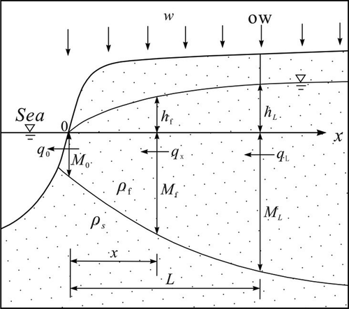
All the hydraulic heads are referenced to the mean sea level. The fresh groundwater flow in the coastal zone is assumed to satisfy the Dupuit assumption. A flow section (approximately a vertical section) at distance x is selected. According to Darcy’s law and the principle of continuum of groundwater flow, the fresh groundwater flow rate of unit width through the vertical section at distance of x = 0, q0 can be expressed as (Zhou et al. Citation2010):
where q0 represents the fresh groundwater discharge into the sea, K is the hydraulic conductivity of the aquifer, hf is the water table at the vertical section of distance x, Mf is the depth of the freshwater–saltwater interface below the mean sea level (or the thickness between the mean sea level and the interface) at the section of x, and w is the infiltration rate of unit area on the land surface. The term Mf in Equation (1) can be determined according to the Ghyben-Herzberg relationship, Mf = δhf, where δ = ρf/(ρs − ρf), ρs and ρf are the densities of saltwater and freshwater, respectively. Thus, Equation (1) can be rewritten as:
or
Equation (2) is derived and integrated between hf = 0 at x = 0 and hf = hL at x = L, giving:
Equation (3) is derived and integrated between Mf = 0 at x = 0 and Mf = ML at x = L, giving:
Equation (3) can also be derived and integrated between Mf = 0 at x = 0 and Mf = Mf at x = x, giving the depth of the interface at any section of distance x (0 < x < L):
Equations (4) and (5) indicate that if L, hL, ML, K, w and δ are known, one can estimate the fresh groundwater discharge into the sea in the coastal zone. Equations (4)–(6) suggest that if the water table hL or the depth of the interface ML at the observation well of distance L are known, that is, only one observation well is required, the fresh groundwater discharge into the sea and the depth of the interface at any distance x (0 < x < L) in the coastal zone can be determined.
From Equation (6), one can notice that when x = 0, Mf = 0, that is, no outlet of fresh groundwater exists along the coastline, which is not the case in realistic coastal zones. This error is caused when the Ghyben-Herzberg relation is used to estimate the depth of the freshwater–saltwater interface. Therefore, Equation (6) is not suitable for estimating the depth of the interface near the coastline. Now it is assumed that the depth of the interface at the coastline (x = 0) is M0 (), and Equation (3) is derived and integrated between Mf = M0 at x = 0 and Mf = ML at x = L, giving:
If M0 = 0, Equation (7) reduces to Equation (5).
Thus, if M0 is known, one can use Equation (7) to estimate q0. However, M0 is not determined easily in general cases. Henry (Citation1959) suggested that M0 can be calculated approximately using the following equation:
Equations (4) and (5) can be used to estimate the submarine fresh groundwater discharge into the sea in a coastal unconfined aquifer with unique vertical infiltration on the land surface. From Equations (4) and (5), one can easily obtain the fresh groundwater flow rate of unit width at any section of x (0 < x < L), qx, and at the section of x = L, qL, as follows (Zhou et al. Citation2010):
or
and
and
or
and
where q0 > qx > qL. Equation (13) is the same as that derived by Bear (Citation1979).
As a special case, if the unique vertical infiltration on the land surface does not exist, i.e., w = 0, Equation (4) reduces to (Zhou et al. Citation2010):
and Equation (5) becomes:
where q is the fresh groundwater flow rate of unit width through any section x (0 ≤ x ≤ L) or fresh groundwater discharge into the sea in a coastal unconfined aquifer without unique vertical surface infiltration. If M0 is considered, Equation (7) reduces to:
From Equation (16) one can obtain:
If ML in Equation (18) represents the vertical distance from the mean sea level to the horizontal lower confining bed of the coastal unconfined aquifer, L in Equation (18) is the distance of the interface toe extending into the unconfined aquifer (Bear Citation1979, Strack Citation1989, Zhou et al. Citation2010, Lu et al. Citation2015). In this case, only one observation well is required to determine the distance ML. However, q and K must be known in advance in calculation of L according to Equation (18), and this is not easy when only one observation well is present. In the following sections, L is estimated when two observation wells are present in a coastal unconfined aquifer where q and K are not known in advance.
Estimation of the length of the freshwater–saltwater interface extending into coastal unconfined aquifers
A coastal unconfined aquifer with a horizontal lower confining bed without vertical infiltration on the land surface
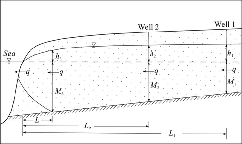
Shown in is a profile showing a coastal unconfined aquifer with a horizontal lower confining bed without vertical infiltration on the land surface. Groundwater discharges into the sea in a homogeneous and isotropic unconfined aquifer. It is assumed that groundwater flow is in a steady state and a freshwater–saltwater interface exists in the coastal zone. The groundwater flow lines from a plane view are parallel to each other and perpendicular to the coastline. The freshwater–saltwater interface toe is at the distance of L from the coast, at which point the hydraulic head and the depth of the interface below the mean sea level are denoted as hL and ML, respectively. Two observation wells, Well 1 and Well 2, are drilled in the same profile, which are at the distances of L1 and L2 (L < L2 < L1) from the coast, respectively. The observation wells tap the lower confining bed at a depth of M1 (= M2 = ML) below the mean sea level. Elevations of the hydraulic heads in Well 1, h1, and Well 2, h2, are measured. The fresh groundwater flow rate per unit width in the unconfined aquifer, q, is expressed as:
Figure 2. Schematic cross-section showing a coastal unconfined aquifer with a horizontal lower confining bed without vertical infiltration on the land surface (L < L2 < L1, ML = M2 = M1).

where K is the hydraulic conductivity of the aquifer.
The discharge of fresh groundwater into the sea is obtained as given in Equation (16). Thus, from Equations (16) and (19), the length of the interface toe from the coast, L, is obtained:
The discharge of fresh groundwater into the sea is also obtained as given in Equation (17) when the outlet of fresh groundwater is considered. Thus, from Equations (17) and (19), the length of the interface toe from the coast, L, is also obtained:
To illustrate the application of Equations (20) and (21), in , let L1 = 1500 m, L2 = 1000 m, h1 = 6 m, h2 = 5 m, M1 = M2 = ML = 50 m, and δ = ρf/(ρs − ρf) = 1.0/(1.025 – 1.0) = 40. According to Equation (20) we obtain:
According to Equation (19), we obtain:
where β1 = 0.111 m. According to Equation (8), when the outlet of fresh groundwater is considered, M0 is obtained by substituting Equation (22) into Equation (8):
Thus, according to Equation (21) we obtain:
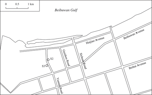
On the northwestern coast of the city of Beihai () in southern Guangxi, China, occur Quaternary and Neogene unconsolidated sediments (5–350 m in thickness). Overlying the basement rocks are Neogene sand with gravel and scattered lenses of clay or sandy clay (N2sh). Overlying the N2sh sediments are sand and gravel with the upper clay layer of the Lower Pleistocene Zhanjiang Group of the Quaternary age (Q1z). The surficial sediments are the lower sand with gravel and upper sandy clay of the Middle Pleistocene Beihai Group of the Quaternary age (Q2b). Along the coast occurs Quaternary Holocene sand (Q4) with thickness of 0–5 m. One unconfined aquifer is roughly grouped in the Q4, Q2b and Q1z sediments on the northwestern coast of the study area, considering the semi-perviousness and termination of the clay (Zhou et al. Citation2000). Under natural conditions, groundwater flows from south to north and discharges into the sea. In 2012 observation wells were drilled along the Yunnan Road and the thickness of the aquifer below the mean sea level is ML = 54.14 m. Groundwater levels were measured in wells S2 and S3, which are L2 = 675.0 m and L1 = 937.50 m from the actual coast, respectively. Groundwater levels in wells S2 and S3 in the dry season (18 January 2013) are selected (i.e. h2 = 1.770 m and h1 = 2.138 m) for the calculation of the extending distance of the interface. It is assumed that fresh groundwater flow was at a steady state at the specific moment. According to Equation (20), the extending distance of the interface can be estimated as L = 477.568 m. When the outlet of fresh groundwater is considered, M0 is obtained as 6.334 m based on q = 0.214K (according to Equation (19)) and Equation (8), and the extending distance of the interface can be estimated as L = 471.032 m.
Figure 3. Location of the observation wells on the northwestern coast of Beihai in Guangxi, China.
A coastal unconfined aquifer with a sloping lower confining bed and without vertical infiltration on the land surface
Shown in is a profile showing a coastal unconfined aquifer with a sloping lower confining bed without vertical infiltration on the land surface. Two observation wells, Well 1 and Well 2, tap the lower confining bed at depths of M1 and M2 below the mean sea level, respectively (ML > M2 > M1). Other conditions are the same as those in . The fresh groundwater flow rate per unit width in the unconfined aquifer, q, is expressed as:
Figure 4. Schematic cross-section showing a coastal unconfined aquifer with a sloping lower confining bed without vertical infiltration on the land surface (L < L2 < L1, ML > M2 > M1). Horizontal arrow is used for q for simplification, but it is not necessarily horizontal.
In , let L1 = 1500 m, L2 = 1000 m, h1 = 6 m, h2 = 5 m, M1 = 40 m, M2 = 45 m, and δ = ρf/(ρs − ρf) = 1.0/(1.025 – 1.0) = 40. According to Equation (23) we obtain:
where β2 = 0.096 m.
As show in , ML can be calculated as follows:
For simplification, Equation (16) is thought to be suitable for the aquifer shown in . Thus, from Equations (16), (26) and (24), we obtain:
From Equation (27) one can obtain:
According to Equation (8) when the outlet of fresh groundwater is considered, M0 is obtained by substituting Equation (24) into Equation (8):
Thus, according to Equations (17), (26) and (24), we obtain:
From Equation (28) one can obtain:
According to Equation (26), one can also obtain ML = 51.465 m when M0 = 0 and L = 353.497 m, and ML = 51.475 m when M0 = 2.845 m and L = 352.615 m. On the coast, where L = 0, the vertical distance from the mean sea level to the lower confining bed is 55 m.
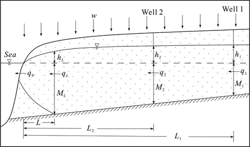
A coastal unconfined aquifer with horizontal lower confining bed and unique vertical infiltration on the land surface
Shown in is a profile showing a coastal unconfined aquifer with a horizontal lower confining bed and unique vertical infiltration on the land surface. Other conditions are the same as those in except the presence of vertical surface infiltration. The fresh groundwater flow rate per unit width through the vertical section of distance L2 in the unconfined aquifer, q2, is expressed as follows:
Figure 5. Schematic cross-section showing a coastal unconfined aquifer with a horizontal lower confining bed and unique vertical infiltration on the land surface (L < L2 < L1, ML = M2 = M1, q0 > qL > q2 > q1).
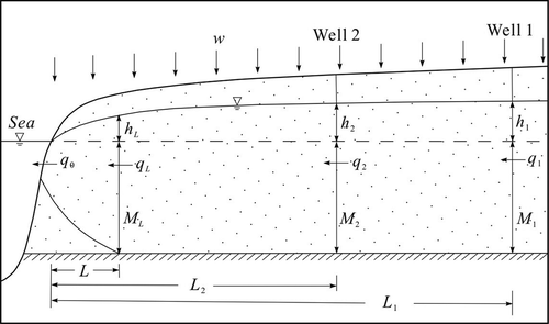
In , let L1 = 1500 m, L2 = 1000 m, h1 = 6 m, h2 = 5 m, M1 = M2 = ML = 50 m, K = 30 m/d, w = 0.01 m/d, and δ = ρf/(ρs − ρf) = 1.0/(1.025 – 1.0) = 40. According to Equation (29) we obtain:
As shown in , qL can be calculated as follows:
where γ1 = 0.01 m/d. According to Equations (13) and (30) we obtain:
From Equation (31), one can obtain:
and qL = 15.211 m2/d when L = 61.914 m.
As shown in , q0 can be calculated as follows:
According to Equation (8) when the outlet of fresh groundwater is considered, M0 is obtained:
Thus, according to Equations (14) and (30) we obtain:
From Equation (32), one can obtain:
We can also obtain qL = 15.273 m2/d when M0 = 15.64 m and L = 55.746 m, and q1 = q2 − w(L1 − L2) = 0.83 m2/d.
A coastal unconfined aquifer with a sloping lower confining bed and unique vertical infiltration on the land surface
Shown in is a profile showing a coastal unconfined aquifer with a sloping lower confining bed and with unique vertical infiltration on the land surface. Other conditions are the same as those in Figure 2 except the existing vertical surface infiltration. The fresh groundwater flow rate per unit width through the vertical section of distance L2 in the aquifer, q2, is expressed as follows:
Figure 6. Schematic cross-section showing a coastal unconfined aquifer with a sloping lower confining bed and unique vertical infiltration on the land surface (L < L2 < L1, ML > M2 > M1, q0 > qL > q2 > q1). Horizontal arrows are used for q0, qL, q2 and q1 for simplification, but they are not necessarily horizontal.
In , let L1 = 1500 m, L2 = 1000 m, h1 = 6 m, h2 = 5 m, M1 = 40 m, M2 = 45 m, K = 30 m/d, w = 0.01 m/d, and δ = ρf/(ρs − ρf) = 1.0/(1.025 – 1.0) = 40. According to Equation (33) we obtain:
As shown in , qL can be calculated as follows:
where γ2 = 0.01 m/d.
ML can be calculated according to Equation (25):
According to Equations (13) and (34), we obtain:
From Equation (35), one can obtain:
and qL = 14.660 m2/d and ML = 54.280 m when L = 71.952 m.
q0 can be calculated as follows:
According to Equation (8) when the outlet of fresh groundwater is considered, M0 is obtained:
According to Equations (14) and (34), we obtain:
From Equation (36), one can obtain:
One can also obtain qL = 14.714 m2/d and ML = 54.334 m when M0 = 15.195 m and L = 66.570 m, and q1 = q2 − w(L1 − L2) = 0.38 m2/d.
Discussion
In the above calculation of distance L in the coastal unconfined aquifers, it is worth noting that the hydraulic conductivity K and the groundwater flow rate q do not need to be known in advance in the aquifers of and with horizontal or sloping lower confined bed and without vertical surface infiltration, when the two observation wells are located far from the coast. However, the hydraulic conductivity K, the infiltration rate of unit area on the land surface w and the groundwater flow rate q must be known in advance in the calculation of L in the coastal unconfined aquifers of and with horizontal or sloping lower confined bed and with vertical surface infiltration, even though two observation wells are present.
In order to examine the factors affecting the value of L, the above methods are used to calculate the distance L of the coastal confined aquifers of the same K for different cases in , , and , considering the absence or presence of vertical surface infiltration, changes in hydraulic gradient, changes in the infiltration rate of unit area on the land surface if the vertical surface infiltration is present, and the outlet of fresh groundwater at the coast M0. The values of ρf = 1.0 g/cm3, ρs = 1.025 g/cm3, L1 = 1500 m and L2 = 1000 m are kept constant for each case. The results are listed in for a rough comparison.
Table 1. Calculation results for the different cases in , , and .
It is found that the vertical surface infiltration has a significant effect on the inland extending distance of the interface L. The values of L for cases 1–8 without vertical surface infiltration are much larger than those of cases 9–24 with vertical surface infiltration. The values of L for cases 9–12 in and cases 17–20 in with lower infiltration rate of 0.005 m/d are also larger than those of cases 13–16 in and cases 21–24 in with higher infiltration rate of 0.01 m/d. Thus, an increase in the groundwater flow rate (which increases towards the sea from q1 to q0 as shown in ) through vertical surface infiltration may effectively control the inland extension of the interface.
In , , and , the hydraulic gradient has an important bearing on the inland extending length of the interface L. The values of L in cases 1, 2, 5, 6, 9, 10, 13, 14, 17, 18, 21 and 22 with lower hydraulic gradient of 0.002 are larger than those of the corresponding cases 3, 4, 7, 8, 11, 12, 15, 16, 19, 20, 23 and 24 with greater hydraulic gradient of 0.0025. Thus, increase in the hydraulic gradient in the aquifer may also control the inland extension of the interface. In particular, Equation (20) or (21) indicates that L is inversely proportional to the hydraulic gradient of the coastal unconfined aquifer when the vertical surface infiltration is absent.
The values of L in the cases of and with sloping lower confining bed are larger than those of the cases of and with horizontal lower confining bed. The reason for this is that the groundwater discharge into the sea in the unconfined aquifer with a sloping lower confining bed is less than that in the aquifer with a horizontal lower confining bed, leading to a longer inland extending distance of the interface. The angle between the sloping surface of the confining bed and the horizontal plane is not larger than 30°, as suggested by Chapman (Citation1980).
In addition, the values of L in the cases of , , and where the outlet of fresh groundwater at the coast M0 is considered are a bit smaller than those of the corresponding cases of , , and where the outlet of fresh groundwater at the coast M0 is not considered. The difference in the values of L under these two conditions is not so obvious as expected.
Conclusion
The inland extending length of the interface toe in coastal unconfined aquifers can be estimated through examining the submarine fresh groundwater discharge in the coastal zones and the fresh groundwater flow rate in the coastal unconfined aquifers, which are assumed to be homogeneous and isotropic. Methods for estimating the length of the interface toe in coastal unconfined aquifers with or without vertical infiltration on the land surface and with a horizontal or sloping lower confining bed require two observation wells at different distances far from the coastline along a profile perpendicular to the coast. As an actual example, the extending distance of the interface on the northwestern coast of Beihai in southern Guangxi, China, in the dry season on 18 January 2013 is estimated as 471–478 m.
The subsurface fresh groundwater discharge into the sea is affected by the location of the freshwater–saltwater interface in coastal unconfined aquifers. The subsurface fresh groundwater discharge also plays an important role in the occurrence of the freshwater–saltwater interface. When vertical surface infiltration exists in the coastal unconfined aquifers, the inland extending lengths of the interface toe are much shorter than those in the coastal unconfined aquifers without vertical surface infiltration. Increase in hydraulic gradient in the unconfined aquifer can also lead to the decrease in the inland extending lengths of the interface toe. When the lower confining bed of a coastal unconfined aquifer slopes towards the sea (the slope angle is not larger than 30°), the fresh groundwater flow rate may decrease compared to that in the coastal unconfined aquifer with horizontal lower confining bed, causing the length of the interface to increase. The submarine fresh groundwater discharge in coastal zones is the key factor affecting the inland extending length of the interface toe. Thus, maintaining or increasing the subsurface fresh groundwater discharge into the sea from the inland unconfined aquifers in different ways, including an increase in groundwater level or hydraulic gradient and an increase in vertical surface infiltration, is vital for the prevention of seawater intrusion in coastal unconfined aquifers.
Although the methods described in this paper involve some assumptions, and thus have certain limits, they offer simple ways of estimating the distances of the interface extending into the coastal unconfined aquifers where only two observation wells are needed. They are relatively easily operated and are suitable in preliminary investigations of regional hydro-geology of coastal areas. More real case studies of the methods will be the subject of future studies.
Disclosure statement
No potential conflict of interest was reported by the authors.
Additional information
Funding
References
- Bear, J., 1972. Dynamics of fluid in porous media. New York: American Elsevier.
- Bear, J., 1979. Hydraulics of groundwater. New York: McGraw-Hill, Inc.
- Bear, J., et al., 1999. Seawater intrusion in coastal aquifers – concepts, methods and practice. London: Kluwer Academic.
- Chapman, T.G., 1980. Modeling groundwater flow over sloping beds. Water Resources Research, 16 (6), 1114–1118. doi:10.1029/WR016i006p01114
- Cheng, A.H.-D. and Ouazar, D., 1999. Analytical solution. In: J. Bear, et al., eds. Seawater intrusion in coastal aquifers – concepts, methods and practice. London: Kluwer Academic, 163–191.
- Dagan, G. and Zeitoun, D.G., 1998. Seawater–freshwater interface in a stratified aquifer of random permeability distribution. Journal of Contaminant Hydrology, 29, 185–203. doi:10.1016/S0169-7722(97)00013-2
- Domenico, P.A. and Schwartz, F.W., 1990. Physical and chemical hydrogeology. New York: John Wiley & Sons.
- Elewa, H.H., et al., 2013. Determining groundwater protection zones for the Quaternary aquifer of northeastern Nile Delta using GIS-based vulnerability mapping. Environmental Earth Sciences, 68 (2), 313–331. doi:10.1007/s12665-012-1740-x
- Essaid, H.I., 1986. A comparison of the coupled freshwater–saltwater flow and the Ghyben-Herzberg sharp interface approaches to modeling of transient behavior in coastal aquifer systems. Journal of Hydrology, 86, 169–193. doi:10.1016/0022-1694(86)90012-0
- Henry, H.R., 1959. Salt intrusion into fresh-water aquifers. Journal of Geophysical Research, 64 (11), 1911–1919. doi:10.1029/JZ064i011p01911
- Isaacs, L.T. and Hunt, B., 1986. A simple approximation for a moving interface in a coastal aquifer. Journal of Hydrology, 83, 29–43. doi:10.1016/0022-1694(86)90181-2
- Izuka, S.K. and Gingerich, S.B., 1998. Estimation of the depth to the fresh-water/salt-water interface from vertical head gradients in wells in coastal and island aquifers. Hydrogeology Journal, 6, 365–373. doi:10.1007/s100400050159
- Kashef, A.I., 1986. Groundwater engineering. New York: McGraw-Hill.
- Kim, K.-Y., Chon, C.-M., and Park, K.-H., 2007. A simple method for locating the freshwater–saltwater interface using pressure data. Ground Water, 45 (6), 723–728. doi:10.1111/gwat.2007.45.issue-6
- Ledoux, E., Sauvagnac, S., and Rivera, A., 1990. A compatible single-phase/two-phase numerical model: 1. Modeling the transient salt-water/fresh-water interface motion. Ground Water, 28 (1), 79–87. doi:10.1111/gwat.1990.28.issue-1
- Lu, C., et al., 2015. A correction on coastal heads for groundwater flow models. Ground Water, 53 (1), 164–170. doi:10.1111/gwat.12172
- Maas, K., 2007. Influence of climate change on a Ghijben-Herzberg lens. Journal of Hydrology, 347, 223–228. doi:10.1016/j.jhydrol.2007.09.020
- Park, Y., et al., 2012. National scale evaluation of groundwater chemistry in Korea coastal aquifers: evidences of seawater intrusion. Environmental Earth Sciences, 66 (3), 707–718. doi:10.1007/s12665-011-1278-3
- Person, M., Taylor, J.Z., and Dingman, S.L., 1998. Sharp interface models of saltwater intrusion and wellhead delineation on Nantucket Island, Massachusetts. Ground Water, 36 (5), 731–742. doi:10.1111/gwat.1998.36.issue-5
- Qiu, H., 1991. Steady water flow model and its application in coastal unconfined aquifers. Transactions of Oceanology and Limnology, 36 (1), 10–15. (in Chinese)
- Rajmohan, N., Al-Futaisi, A., and Al-Touqi, S., 2009. Geochemical process regulating groundwater quality in a coastal region with complex contamination sources: Barka, Sultanate of Oman. Environmental Earth Sciences, 59 (2), 385–398. doi:10.1007/s12665-009-0037-1
- Reilly, T.E. and Goodman, A.S., 1985. Quantitative analysis of saltwater–freshwater relationships in groundwater systems – a historical perspective. Journal of Hydrology, 80, 125–160. doi:10.1016/0022-1694(85)90078-2
- Robinson, C., et al., 2007. Salt–fresh water dynamics in a subterranean estuary over a spring-neap tidal cycle. Journal of Geophysical Research – Oceans, 112 (C9), C09007. doi:10.1029/2006JC003888
- Rushton, K.R., 1980. Differing positions of saline interfaces in aquifers and observation boreholes. Journal of Hydrology, 48, 185–189. doi:10.1016/0022-1694(80)90074-8
- Singh, S.P. and Stammers, W.N., 1989. A potential theory-based finite element algorithm for freshwater recharge of saline aquifers: a sharp interface model. Water Resources Research, 25 (7), 1685–1694. doi:10.1029/WR025i007p01685
- Strack, O.D.L., 1976. A single-potential solution for regional interface problems in coastal aquifers. Water Resources Research, 12 (6), 1165–1174. doi:10.1029/WR012i006p01165
- Strack, O.D.L., 1989. Groundwater mechanics. London: Prentice Hall.
- Tang, X.Q., et al., 2007. Numerical simulation of fresh-saline water interface regularities in coastal areas duo to the tidal fluctuation. Journal of Safety and Environment, 7 (4), 84–92. (in Chinese)
- Trabelsi, R., et al., 2012. Groundwater salinization processes in shallow coastal aquifer of Djeffara plain of Medenine, Southeastern Tunisia. Environmental Earth Sciences, 66 (2), 641–653. doi:10.1007/s12665-011-1273-8
- Urish, D.W. and McKenna, T.E., 2004. Tidal effects on ground water discharge through a sandy marine beach. Ground Water, 42, 971–982. doi:10.1111/gwat.2004.42.issue-7
- Van der Veer, P., 1977. Analytical solution for steady interface flow in a coastal aquifer involving a phreatic surface with precipitation. Journal of Hydrology, 34, 1–11. doi:10.1016/0022-1694(77)90058-0
- Xun, Z., Haiyan, Z., and Li, Z., 2008. Characteristics of piezometric heads and determination of freshwater–saltwater interface in the coastal zone near Beihai, China. Environmental Geology, 54 (1), 67–73. doi:10.1007/s00254-007-0793-8
- Xun, Z. and Ying, W., 2009. Brief review on methods of estimation of the location of a freshwater–saltwater interface with hydraulic heads or pressures in coastal zones. Ground Water Monitoring & Remediation, 29 (4), 77–84. doi:10.1111/gwmr.2009.29.issue-4
- Zhou, X., 2011. A method for estimating the fresh water– salt water interface with hydraulic heads in a coastal aquifer and its application. Geoscience Frontiers, 2 (2), 199–203. doi:10.1016/j.gsf.2011.02.003
- Zhou, X., 2014. Determination of the distance of the freshwater–saltwater interface extending into coastal confined aquifers. Environmental Earth Sciences, 71 (3), 1311–1317. doi:10.1007/s12665-013-2537-2
- Zhou, X., et al., 2000. Numerical simulation of seawater intrusion near Beihai, China. Environmental Geology, 40 (1–2), 223–233. doi:10.1007/s002540000113
- Zhou, X., et al., 2010. Special Topics on Groundwater Sciences. Beijing: Geological Publishing House. (in Chinese)