
ABSTRACT
Any human intervention or action in karst terrains can unexpectedly, suddenly, strongly and, generally, dangerously change a local and/or a regional hydrological regime. A characteristic example of the Dinaric karst is given in this paper. The operation of two reservoirs in Livanjsko Polje at an altitude of about 702 m above sea level (m a.s.l.) and hydro-electric development of the Cetina River system started in 1973. This year marked a drastic and instantaneous change in the regional hydrological regime. A significant drop in the minimum, mean and maximum annual discharges of two neighbouring karst springs, Rumin Mali and Rumin Veliki, was caused by this anthropogenic construction. The exits of the two analysed karst springs, Rumin Mali and Veliki, are located at altitudes of about 326.8 m a.s.l. and 307.6 m a.s.l. respectively. The areal distance between them is 640 m. Their hydrological regimes have been altered in different ways. The drop in discharges is stronger for the Rumin Veliki than for the Rumin Mali. The analysis shows that the system development influenced the redistribution of the regional karst aquifer and, in this manner, contributed to the reduction of both karst springs’ recharge areas.
Editor D. Koutsoyiannis Associate editor E. Rozos
1 Introduction
Unfavourable living conditions on karst have, since ancient times, forced people living in these areas to build various hydrotechnical structures (Bonacci Citation1987). They were built to improve living conditions, mainly by changing the water regime. In the region of the Dinaric karst these works were especially intensive between 1950 and 1980. Nowadays, experience has shown that many of the works have resulted in unexpected, negative consequences. Unknown and huge surface and underground karst formations represent the main reason for this type of hazardous consequences. Despite all scientific efforts and technological development, science still has not been able to reliably foresee possible consequences of anthropogenic interventions in karst areas (Bonacci Citation2004). A detailed hydrological description of such a case is given in this paper.
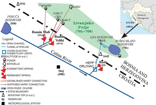
The study area is located in the central part of the Dinaric karst in Croatia and Bosnia and Herzegovina. shows a schematic location map of the study area indicating three karst springs, the ponors in Livanjsko Polje, karst groundwater connections, the Sinj meteorological station and the Cetina River hydroelectric system (reservoirs, the Orlovac hydroelectric power plant). The maximum volumes, V, and altitudes, H, of the two reservoirs whose influence is crucial on the changes of the regional hydrological–hydrogeological regime are (1) Buško Blato Reservoir (V = 782 × 106 m3, Hmax = 716.40 m a.s.l.); (2) Lipa Reservoir (V = 1.38 × 10⁶ m3, Hmax = 703.50 m a.s.l.). Altitudes in m above sea level (m a.s.l.) of all the locations are indicated in . The hydroelectric system started operation in 1973 (Bonacci and Roje-Bonacci Citation2003).
Figure 1. Schematic location map of the study area indicating the karst springs, the ponors in Livanjsko Polje, karst groundwater connections, the reservoirs, the Orlovac HEPP and the Sinj meteorological station with their altitudes.
shows a location map of the two analysed karst springs, Rumin Mali and Rumin Veliki, indicating altitudes of their exits. For the Rumin Mali and Rumin Veliki Springs these altitudes are 326.8 m a.s.l. and 307.6 m a.s.l., respectively. The photograph presented in shows the location of the Rumin Veliki Spring with the position of an automatic water-level gauging station.
Figure 2. Location map of the two analysed karst springs: the Rumin Mali and the Rumin Veliki.
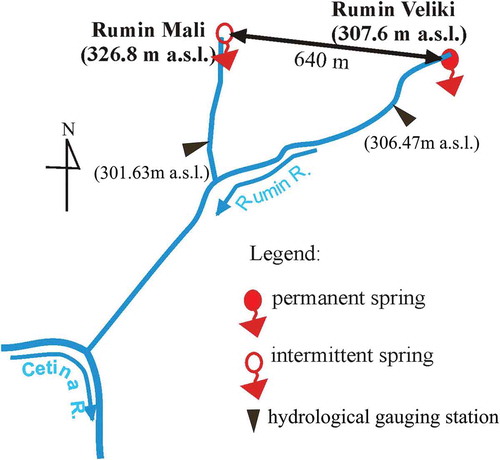
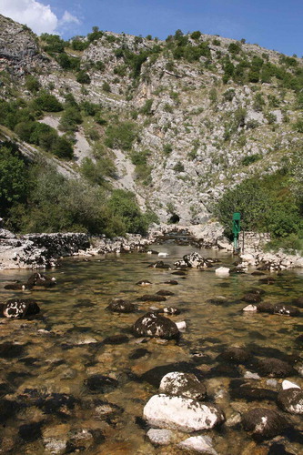
Figure 3. The location of the Rumin Veliki Spring showing the automatic water-level gauging station. Photo: N. Buzjak.
The distance between the two analysed karst springs is only 640 m. The Rumin Mali Spring’s coordinates are latitude 43°46ʹ45ʹʹN and longitude 16°39ʹ08ʹʹE. The Rumin Veliki Spring’s coordinates are latitude 43°46ʹ47ʹʹN and longitude 16°39ʹ37ʹʹE .
The main goal of this paper is to show how anthropogenic interventions in karst can have unexpected and possibly dangerous consequences. The authors’ intention is to raise awareness about any kind of human intervention in karst terrains.
2 Study area and data used
2.1 Geology and speleology of the study area
The catchment areas of the karst springs Rumin Veliki and Rumin Mali, constituting a greater catchment area of the River Cetina, are illustrative of a mixed karst denudation system (Ford and Williams Citation2007). They are a consequence of regional geological conditions, hydrogeological relations and geomorphological structure of an area whose principal feature is well-developed karst porosity (Magdalenić Citation1971).
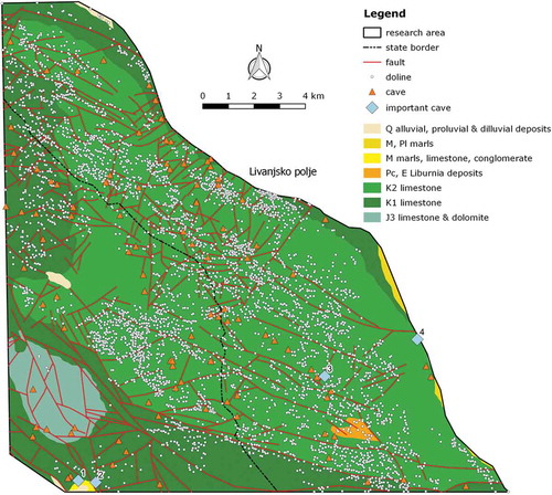
The geologically and geomorphologically analysed study area spreads over a predominantly karst zone of the Dinara Mountain and a smaller area of the Kamešnica Mountain at the far southeast corner of a wider border area between Croatia and Bosnia and Herzegovina (). A geological map of the study area is given in (Papeš et al. Citation1982). The terrain is dominated by permeable Cretaceous and Jurassic carbonate layers characterized by well-developed karst porosity. Apart from the tectonically predisposed secondary porosity, a high percentage of CaCO3 (80–97%) contributes to the well-developed karst features of the area. The oldest layers date back to the Jurassic and are represented by layers of limestone and dolomite. The central Dinara Mountain area is made of well-stratified Early Cretaceous limestone, whereas the highest areas consist of well-stratified limestone with rudists from the Late Cretaceous. On a smaller area between the Dinara and Kamešnica Mountains, it is possible to identify limestone originating from the Paleocene and Eocene epochs.
Figure 4. Study area hypsometric map.
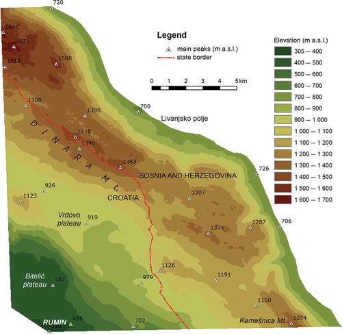
Figure 5. Study area geological map (Papeš et al. Citation1982). Important caves: (1) Rumin Mali Spring, (2) Rumin Veliki Spring, (3) Nevidna Voda, (4) Veliki Ponor.
Due to the high purity, thickness, and the amount of tectonically induced fissures of carbonate layers in the mountainous hinterland of both Rumin karst springs, deep karst with numerous karst phenomena has developed.
The tectonic structure between Livanjsko Polje and the valley of the Cetina River is made of tectonic units of the Dinara and Kamešnica Mountains. The principal groundwater flow paths running from Livanjsko Polje towards the springs of the Cetina River catchment area follow existing transverse and diagonal faults. Livanjsko Polje, located in the northeastern part of the study area, presents an allogenic part () of the system of the analysed karst catchment areas. It is a local erosion base and the catchment area of karst waters that come from the neighbouring karst aquifers originating in Bosnia and Herzegovina. Its network of subterranean rivers disappearing in a number of sinkholes in the southwest edge of the field presents a concentrated entrance of waters that are directed and run along predefined underground paths towards the springs located on the left flank of the Cetina Valley.
Figure 6. Cross-section of mixed karst denudation system of the Rumin Veliki Spring catchment area between the ponor zone in Livanjsko Polje and the Rumin Veliki Spring.
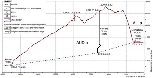
The Dinara Mountain represents an autogenic element of the observed system (). The central part of the massif is an area of deep karst. Based on data on the depth of known cave passages and the levels of underground water, it has been found that the depth of the vadose zone, that is, the vertically measured difference between the land surface and the phreatic zone, reaches as much as 1000 m. Due to an indented and karstified terrain predominantly consisting of carbonates, precipitation easily penetrates areas below the surface, thus feeding a deep, karst aquifer.
Given its carbonate structure and the annual amount of precipitation, the Dinara Mountain presents an important reservoir from which significant amounts of water infiltrate below the surface. The direction of the water is governed by a system of well-karstified fractures all the way to the deep Dinara karst aquifer. The drainage of the subterranean waters from the aquifer is dominantly in the southwest direction, i.e. towards the valley of the Cetina River and its tributaries as local erosion bases.
Based on morphological and hydrological characteristics, it is possible to identify three geomorphological units: (1) the boundary zone of Livanjsko Polje; (2) a hypsometrically higher Dinara zone; (3) a hypsometrically lower zone of Sinjsko Polje. At the western edge of Livanjsko Polje, there are several big caves, which act as a swallow-holes. Their allogenic tributaries from the Livanjsko Polje sink into the karst Dinara Mountain massif at an altitude of 700 m a.s.l.
The Dinara Mountain range with its high plateau is an area of deep karst with particularly well-developed epikarst and a deep vadose zone. The most important speleological formation in the study area is the vertical cave Nevidna Voda (). The cave is hydrologically active during the whole year. In the vadose vertical passage at a depth of 250 m below the surface, a permanent water stream occurs and flows deeper towards the lake at a depth of 653 m below the surface (Rnjak Citation2009). The stream flow depends highly on the precipitation (Andrić and Željković Citation2012). The depth of the lake in the submerged vertical passage is unknown since the cave has not been explored by diving. Below its surface, cavers have observed submerged stalactites that could only have formed in dry conditions.
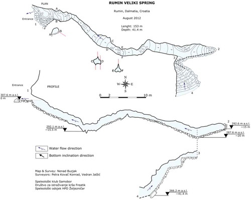
According to the data given by speleological research, 107 caves have been found in the study area, of which so far only a third have been investigated. Given the vastness of the area and favourable conditions for the process of speleogenesis, the number of such formations is probably even greater than is currently thought. Due to the morphological characteristics of the area, it is possible to find caves and shafts up to a hundred metres deep (Borovec et al. Citation2006, Baković et al. Citation2007, Tutiš Citation2011). Their morphological features are simple and highly predisposed by tectonic and structural elements influencing the direction and cross-sections of their passages. and represent the Rumin Mali and the Rumin Veliki cave maps, respectively.
Figure 7. Cave map of the Rumin Mali Spring.
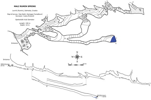
Figure 8. Cave map of the Rumin Veliki Spring.
2.2 Climatology and hydrology
The climate of Livanjsko Polje is continental, while for the topographic catchment of the two analysed karst springs it varies between Mediterranean (at the downstream lower part) and continental (at the higher altitudes).
The mean annual precipitation in the study area varies between 1100 and 2700 mm depending on the altitude and distance from the Adriatic Sea. Areal precipitation distribution follows a well-developed topography. Data on annual precipitation measured from 1950 to 2013 at the Sinj meteorological station (altitude 308 m a.s.l.) are used in this paper. The average annual precipitation for the whole analysed period is 1191 mm, and ranges between 822 mm (1983 year) and 1686 mm (2010 year).
presents the characteristic average discharges (minimum annual, Qmin, average annual, Qmean, maximum annual, Qmax) in the following two subperiods: (1) in their natural state 1950–1972; and (2) after the system development 1973–2013. Results of t-tests (in ) designate statistically significant decreases of all annual characteristic discharges in both analysed karst springs, except in the case of minimum annual discharges of the Rumin Mali Spring.
Table 1. Characteristic average discharges (minimum annual Qmin, average annual Qmean, maximum annual Qmax) (m3 s−1) in the two subperiods: (1) in the natural state 1950–1972; (2) after system development 1973–2013. Statistically significant differences of the t-test are designated in italic.
and reveal that the Rumin Mali Spring is intermittent, whereas the Rumin Veliki Spring is permanent. Due to lack of detailed groundwater level monitoring, it is not possible to reliably explain the hydrogeological connection between these two karst springs and their catchments. The Rumin Mali Spring dried up in 30 of the years between 1950 and 2013. The longest period without discharge was between the end of May 1994 and the beginning of January 1995, lasting more than 6 months.
The maximum measured discharges at the Rumin Mali and Rumin Veliki Springs have never exceeded 19.2 m3 s−1 (1978 year) and 106 m3 s−1 (1970 year) respectively, despite the fact that the precipitation in the area is very intensive and abundant during the wet and cold period of the year. In the last columns of , the data indicating average annual maximum discharge confirm that differences in the two subperiods for both karst springs are smaller than for the mean annual discharge. This can be explained by their limited maximum outflow capacity (Bonacci Citation2001a), which causes groundwater overflow and/or storage in the epikarst zone.
Definition of karst spring catchment area and boundaries is one of the greatest problems of karst hydrology and hydrogeology, and is not yet adequately solved. A simple hydrological method, based on the relationship between mean annual discharges and annual rainfall falling on the catchment, is used in order to assess the hydrological–hydrogeological catchment of the two analysed karst springs before and after the construction of the hydroelectric system. For two time series linear regression analysis was used, and the linear correlation coefficient was calculated. Correlation was tested using Spearman’s rank correlation; values of P < 0.01 were considered significant.
3 Results and discussion
3.1 Analyses of the annual characteristic discharges
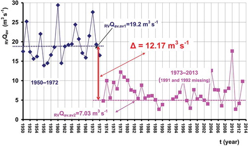
shows two time data subseries of the mean annual discharge measured at the Rumin Veliki gauging station RVQav for two subperiods: (1) 1950–1972, before the beginning of the operation of the Buško Blato Reservoir; and (2) 1973–2013 (data for 1991 and 1992 are missing), after its operation. A break in measurements due to actions of war in the study area took place in the period between 1 September 1991 and 30 June 1992. In the first subperiod (1950–1972), i.e. while the system was in its natural, unaffected state, the average discharge was 19.2 m3 s−1, ranging between 13.9 m3 s−1 and 29.4 m3 s−1. In the second subperiod (1973–2013 with data missing for 1991 and 1992), after the reservoirs had been put into operation, the average discharge was 7.03 m3 s−1, ranging between 2.65 m3 s−1 and 17.6 m3 s−1. A sudden and drastic statistically significant drop in the average annual discharge between the two subperiods of 12.17 m3 s−1 has been observed. Due to the system operation, the recent average annual discharge is 63.2% lower than it was during the natural state of the study area.
Figure 9. Two time data subseries of the mean annual discharge measured at the Rumin Veliki gauging station for the two subperiods: (1) 1950–1972 and (2) 1973–2013 (1991 and 1992 missing).
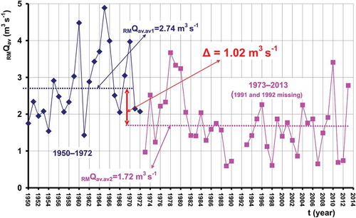
shows two time data subseries of the mean annual discharge measured at the Rumin Mali gauging station RMQav for the two subperiods: (1) 1950–1972, before the start of operation of the Buško Blato Reservoir; and (2) 1973–2013 (data for 1991 and 1992 are missing), after it was put into operation. In the first subperiod (1950–1972), i.e. during the natural state of the system, the average discharge was 2.74 m3 s−1, ranging between 1.43 m3 s−1 and 4.89 m3 s−1. In the second subperiod (1973–2013 with data missing for 1991 and 1992), after the system was put into operation, the average discharge was 1.72 m3 s−1, ranging between 0.594 m3 s−1 and 3.67 m3 s−1. An immediate and drastic statistically significant drop in the average annual discharge of 1.02 m3 s−1 has been observed. Due to the system operation the recent average annual discharge is 37.2% lower than in the period of the natural hydrological–hydrogeological state. It should be noted that the operation of the system had a stronger influence on the Rumin Veliki than the Rumin Mali hydrological regime.
Figure 10. Two time data subseries of the mean annual discharge measured at the Rumin Mali gauging station for the two subperiods: 1950–1972 and 1973–2013 (1991 and 1992 missing).
presents the dependence between mean annual discharges of the Rumin Veliki Spring RVQav and the Rumin Mali Spring RMQav with linear regression lines and the linear correlation coefficients r defined for the two subperiods: (1) 1950–1972 (upper lines), before the start of the operation of the Buško Blato Reservoir; and (2) 1973–2013 (data for 1991 and 1992 are missing) (lower lines), after its operation. In both subperiods linear correlation coefficients r are relatively high. This is proof of similarities in their hydrological regimes. The linear correlation coefficient for the recent subperiod is much higher (r = 0.910) than during the first subperiod (r = 0.751).
Figure 11. Mean annual discharge of the Rumin Veliki Spring RVQav (m3 s−1) versus the Rumin Mali Spring RMQav (m3 s−1) with linear regression lines and the linear correlation coefficients, r, for the two subperiods: (1) 1950–1972 (upper lines) and (2) 1973–2013 (1990 and 1991 missing) (lower lines).
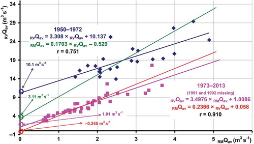
During the natural state (period 1950–1972), drying of the Rumin Mali Spring occurred when the discharge of the Rumin Veliki dropped below 2.5 m3 s−1. In the recent period (1973–2013), drying started when the discharge of the Rumin Veliki dropped below 0.25 m3 s−1.
Similarity in the hydrological regimes of two neighbouring karst springs is a normal consequence of their similar geological settings and the practically identical regional climatological characteristics of their catchments. In the first subperiod, two linear regression lines RVQav = f(RMQav) and RMQav = f(RVQav) cross the ordinate at RVQ = 10.1 m3 s−1 and RVQ = 3.11 m3 s−1 respectively. From the hydrological point of view, this is unusual behaviour. For non-karst terrains it is expected that the regression lines for two neighbouring springs or rivers with catchments developed in similar geological and climatological conditions pass through the origin of a coordinate system or close to it due to unavoidable random mistakes in the definition of the mean annual discharge. In karst terrains the fact that they do not pass through a point of origin can be explained with occasional recharge and/or overflow from other neighbouring catchments (e.g. Fabre and Perrineau Citation2001, Bonacci and Andrić Citation2008, Ravbar and Goldscheider Citation2009, Bailly-Comte et al. Citation2012, Ravbar et al. Citation2012, Birk et al. Citation2014). In the analysed case, occasional overflow occurs from Livanjsko Polje through the ponors designated in .
In the second subperiod, the two linear regression lines RVQav = f(RMQav) and RMQav = f(RVQav) cross the ordinate at RVQ = 1.01 m3 s−1 and RVQ = −0.245 m3 s−1, respectively. In this subperiod the regression lines practically pass through the origin. This can be explained by the fact that, due to the system operation, spring recharge from Livanjsko Polje no longer occurs. Possibly, this recharge is strongly decreased and it occurs only for a short time and after extremely intense precipitation, which may cause flooding in some parts of Livanjsko Polje. It is obvious that the system operation reduced the catchment areas of both analysed springs.
3.2 Relationship between mean annual discharge and annual precipitation
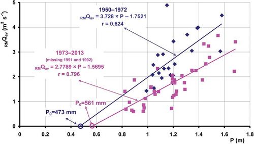
shows the linear regressions between the mean annual discharge RMQav measured at Rumin Mali and annual precipitation P measured at the Sinj gauging station during the following two subperiods: (1) 1950–1972 (upper line) and (2) 1973–2013 (1990 and 1991 missing) (lower line). In the first subperiod the regression line crosses the abscissa at the point P0 = 473 mm, whereas in the second, it crosses at the point P0 = 561 mm. The values for the second subperiod for both analysed springs are practically the same. The linear correlation coefficient for the second period is r = 0.726, whereas in the first period it is r = 0.624. The difference between them is lower than in the case of the Rumin Veliki Spring. It can be concluded that the Rumin Mali Spring in its natural state was fed by water from the Livanjsko Polje horizon in very small quantities, especially in comparison with the case of the Rumin Veliki Spring, all of which supports previously known facts and data.
Figure 12. Linear regressions between the mean annual discharge RMQav (m3 s−1) measured at Rumin Mali and annual precipitation P (m) measured at the Sinj gauging station, during the two subperiods: (1) 1950–1972 (upper line) and (2) 1973–2013 (1990 and 1991 missing) (lower line).
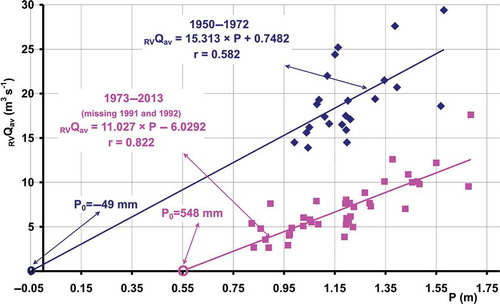
shows the linear regressions between the mean annual discharge RVQav measured at Rumin Veliki and annual precipitation P measured at the Sinj gauging station, during the following two subperiods: (1) 1950–1972 (upper line) and (2) 1973–2013 (1990 and 1991 missing) (lower line). The regression line for the first subperiod crosses the abscissa at the point P0 = −49 mm. This can be explained by the fact that the Rumin Veliki Spring in this subperiod is fed with water coming from an occasional overflow from Livanjsko Polje. In the second subperiod the regression line crosses the abscissa at the point P0 = 548 mm, which indicates that the overflow from Livanjsko Polje is either interrupted or significantly reduced. It should be noted that the linear correlation coefficient for the second period (r = 0.822) is significantly higher than is the case in the first period (r = 0.582), which supports the previously mentioned conclusion.
Figure 13. Linear regressions between the mean annual discharge RVQav (m3 s−1) measured at Rumin Veliki and annual precipitation P (m) measured at the Sinj gauging station during the two subperiods: (1) 1950–1972 (upper line) and (2) 1973–2013 (1990 and 1991 missing) (lower line).
3.3 Determination of the catchment (recharge) area
A catchment (recharge) area in karst represents a complex system composed of numerous (generally unknown) and extremely varied surface and underground karst formations. Due to its heterogeneity and anisotropy, unexpected water circulation may occur in such a space. An additional problem regarding catchment boundaries and area definition is the fact that connections between surface water and groundwater can change very fast in time and space as a result of both natural processes and anthropogenic interventions. These changes can be either occasional or permanent. Discovery and quantification of these connections is in many cases impossible, which is the main reason why the definition of an exact catchment in karst is an extremely complex task and very often unresolved. Taylor and Greene (Citation2008) state: “For a karst aquifer, the traditional concept of the term ‘ground-water basin’ is somewhat of a misnomer in that it minimizes the highly interconnected nature of surface and subsurface waters and the role of concentrated stormwater runoff as a significant source of recharge.”
Numerous and extremely varied surface and underground karst forms allow unexpected connections of waters in the karst medium space. Because of fast groundwater level oscillations, catchment boundaries of karst springs are time variant. In karst terrains, groundwater and surface water constitute a single dynamic system.
The groundwater and surface water are hydraulically connected through numerous karst forms that facilitate and govern the exchange of water between the surface and subsurface (Katz et al. Citation1997). A complex underground conduit system, as well as interplay of pervious and impervious layers of the karst massif are an inherent characteristic of many (practically all) karst systems. Groundwater and surface water exchange with both adjacent and distant aquifers through underground routes or inflows from surface streams, natural lakes and, in recent times, artificial reservoirs. Due to their heterogeneous nature, karst aquifers pose a major challenge for hydrogeological investigations. Important procedures such as the delineation of catchment areas for springs are hindered by the unknown locations and hydraulic properties of highly conductive karstic zones (Oehlmann et al. Citation2013). In order to solve this extremely complex task, different authors use various approaches, concepts and methods from very complex (e.g. Oehlmann et al. Citation2013) to simple (e.g. Ristić Vakanjac et al. Citation2013). Oehlmann et al. (Citation2013) concluded that the representation of heterogeneities has a large influence on the delineation of the catchment areas. Not only the locations of highly conductive elements but also their geometries play a major role in the resulting hydraulic head distribution and thus for catchment area delineation.
Knowledge of the basin area is the starting point in all hydrological and water resources analyses. The determination of the exact catchment area and boundaries of any water body in karst is an extremely difficult task. The main reasons are a direct and complex interaction between groundwater and surface water, as well as unknown underground karst features and their changeable role in water circulation. In order to exactly define the surface and subsurface catchment boundaries, it is necessary to conduct detailed geological investigations and, accordingly, extensive hydrogeological measurements. This can be exactly and completely carried out only with very close cooperation between various scientists (geologists, hydrogeologists, speleologists, hydrologists and geographers etc.)
It should be stressed that all groundwater systems can have a variable recharge area or hydrodynamics (i.e. mobile boundaries) as a function of recharge and varying boundary conditions (quite often when the boundaries have a varying hydraulic head) (e.g. Cambi and Dragoni Citation2000, Dijksma et al. Citation2003, Winter et al. Citation2003, Bidwell et al. Citation2008). Of course, this is the norm in the case of karstic springs, where the phenomenon is elevated, but by no means is it a unique case.
Atkinson (Citation1986) stressed that in soluble rock terrains, more than in most other terrains, the unexpected should always be expected. Karst represents an extremely heterogeneous spatial medium. Circulation of water over and through it can be explained only by the use of a great number of measurement points and by continuously monitoring and measuring different parameters. A karst environment provides the opportunity to delve into its inner secrets to enable confirmation or revision of our ideas, theories and engineering solutions.
Both analysed karst spring catchments are characterized by point and diffuse recharge. Point recharge is highly transient and may occur in relatively short time periods. It is capable of replenishing a large volume of water, even from a single extreme rainfall event. In the study area, precipitation of intensity higher than 100 mm in a few hours occurs at least two times a year.
In this contribution, a simple, conventional hydrological method will be used (not specifically developed for karst areas) to assess the average recharge area of the Rumin Mali and the Rumin Veliki karst springs. The main reason for using this method is that there is no groundwater level measurement in the analysed area and there has been no tracing test since the construction and operation of the reservoirs and hydroelectric system. The method requires only (1) mean annual discharges of a spring and (2) annual precipitation falling on its catchment.
The equations of the linear regression between mean annual discharges Qav (m3 s−1), and annual precipitation P (m), in two subperiods, for the two analysed karst springs (see and ) are:
for the first subperiod (1950–1972)
for the second subperiod (1973–2013)
These equations will be used to determine the average recharge area of the Rumin Mali and Rumin Veliki Springs. Mean annual discharge Qav (m3 s−1), can be defined by the following equation:
where t represents number of seconds in a year (31 536 000 in a regular year and 31 622 400 in a leap year); P is annual precipitation (m); A is average recharge area (m2); and c is a dimensionless annual effective infiltration coefficient (runoff coefficient). Inserting Equation (5) in Equations (1)–(4) it is possible to define Equations (6)–(9), which can serve for the determination of average recharge area A (m2):
for the first subperiod (1950–1972)
for the second subperiod (1973–2013)
In Equations (6)–(9) the only unknown parameter is the annual effective infiltration coefficient c. It represents one of the basic hydrological parameters: the one that integrates absolutely all processes that have occurred in the catchment (Savenije Citation1996, Wu et al. Citation1996, Bonacci Citation2001b). In the Dinaric karst it varies within a relatively narrow range between 0.4 and 0.6 (Bonacci Citation1987, Citation2001b, Žugaj Citation1995). The average annual precipitation measured at the Sinj rain-gauging station during the two subperiods is (1) 1.206 m (1950–1972) and (2) 1.183 m (1973–2013). Using Equations (6)–(9) and the previously noted values of annual precipitation, as well as three values for the annual effective infiltration coefficient (0.4, 0.5 and 0.6), it is possible to calculate the average recharge area of the Rumin Mali and Rumin Veliki Springs for the two subperiods. The results of these calculations are given in . These values should be considered as a rough assessment. It must not be neglected that the areal precipitation could be different from the one used in previous calculations. The calculated values show that the average recharge areas of the Rumin Mali and Rumin Veliki Springs decreased by about 35% and 63%, respectively. Furthermore, it can be concluded that the system operation has had a lower influence on the hydrological regime of the Rumin Mali Spring than it has had on the Rumin Veliki Spring.
Table 2. Average recharge area of the Rumin Mali Spring RMA and Rumin Veliki Spring RVA (km2) calculated using Equations (6)–(9).
4 Conclusions
In this paper, a case of very special hydrological–hydrogeological behaviour of two neighbouring karst springs from the central part of the deep and well-developed Dinaric karst has been addressed. Based on the existing pool of knowledge, it seems that the springs are not hydrogeologically interconnected despite the fact that their areal distance is only 640 m. The objective of this paper was the examination of the effects of hydroelectric development on the hydrological regime of the Rumin Mali and the Rumin Veliki Springs. Their spring exits are located at altitudes of 326.8 m a.s.l. (Rumin Mali) and 307.6 m a.s.l. (Rumin Veliki). The bottoms of two reservoirs, the Buško Blato and the Lipa reservoirs, are at an altitude higher than 700 m a.s.l. Their construction and operation have had the strongest influence on the changes of the hydrological–hydrogeological regime of the two analysed karst springs. Their development and operation caused an instantaneous and drastic decrease in mean annual discharge of both analysed springs. The Rumin Mali and the Rumin Veliki mean annual discharges have decreased by 36.5% and 63.4%, respectively. Furthermore, the decrease in maximum annual discharge for both springs is lower. For the Rumin Mali Spring it is 27.8%, whereas for the Rumin Veliki Spring the decrease amounts to only 11.1%. The minimum annual discharge for the Rumin Veliki Spring is 78% lower than it was during its natural regime. The changes in the minimum annual discharge of the Rumin Mali Spring were not established.
The results and conclusions offered in this paper will lead to a better understanding of the impacts of the development of any hydroelectric power plant (HEPP) on karst river hydrology. It is worth pointing out that artificial reservoirs and HEPPs connected with them are rather common anthropogenic constructions in karst areas. The need to better understand the impact of a HEPP construction and development on hydrological and hydrogeological processes in karst terrains is of crucial importance to ensure sustainable development of vulnerable karst systems and better management of their valuable water resources
In the case of the two analysed neighbouring karst springs, the highest degree of possible dangerous influence on their natural hydrogeological–hydrological regime is due to the construction of the large Buško Blato Reservoir, which has a surface area of 55.8 km2. In this paper a few dilemmas have been solved, but the investigation has indicated the necessity of performing further detailed inter- and multi-disciplinary measurements and analyses.
Manmade actions in karst areas can cause changes of water circulation on different time and space scales. Human interventions, especially construction of artificial reservoirs, as well as inter-basin water transfers, can introduce instantaneous and distinct local and regional changes in catchment areas and boundaries. Dreybrodt et al. (Citation2002) warn that artificial reservoirs in karst accelerate evolution of new karst channels below the dam, and can result in washing out the clay or sand from clogged karst conduits. These processes can cause serious water losses within the reservoir lifetime. Generally these changes are unforeseeable, unexpected and with hazardous consequences. Occurrence of landslides and floods, collapse of dolines, regional water redistribution, drying up of karst springs, conflicts on internationally shared aquifers etc. can be caused (Bonacci Citation2004).
About 50 years ago, at the time of construction of the above-mentioned hydroelectric system, environmental awareness was poor. It is highly probable that the decrease in the characteristic annual discharge has negatively influenced the rich, vulnerable and valuable surface and underground karst environment. We hope that this paper will present a starting point for a discussion that should lead to better results in preserving the extraordinary biodiversity of this broader karst region.
Disclosure statement
No potential conflict of interest was reported by the authors.
References
- Andrić, I. and Željković, I., 2012. Analiza fizikalno-kemijskih parametara tekuće vode unutar jame u odnosu na vanjske meteorološke podatke - primjer jame Nevidna voda, BiH. In: Proceedings of the Symposiu Čovjek i Krš, Bijakovići – Međugorje, Bosnia and Herzegovina. 11–14 November, Sarajevo: Centar za krš i speleologiju, 213–222.
- Atkinson, T.C., 1986. Soluble rock terrains. In: P. Fookes and P.R. Vaughan, eds. Handbook of engineering geomorphology. New York: Chapman and Hall, 241–257.
- Bailly-Comte, V., et al., 2012. A conceptual semidistributed model of the Coulazou River as a tool for assessing surface water - karst groundwater interactions during flood in Mediterranean ephemeral rivers. Water Resources Research, 48 (9), W09534, 1–14. doi:10.1029/2010WR010072
- Baković, R., Pleše, D., and Buzjak, N., 2007. Speleološka ekspedicija Vrdovo 2007. Subterranea Croatica, 10, 3–10.
- Bidwell, V.J., Stenger, R., and Barkle, G.F., 2008. Dynamic analysis of groundwater discharge and partial-area contribution to Pukemanga Stream, New Zealand. Hydrology and Earth System Sciences, 12, 975–987. doi:10.5194/hess-12-975-2008
- Birk, S., Wagner, T., and Mayaud, C., 2014. Threshold behavior of karst aquifers: the example of the Lurbach karst system (Austria). Environmental Earth Sciences, 72 (5), 1349–1356. doi:10.1007/s12665-014-3122-z
- Bonacci, O., 1987. Karst hydrology with special reference to the Dinaric karst. Berlin: Springer-Verlag.
- Bonacci, O., 2001a. Analysis of the maximum discharge of karst springs. Hydrogeology Journal, 9 (4), 328–338. doi:10.1007/s100400100142
- Bonacci, O., 2001b. Monthly and annual effective infiltration coefficients in Dinaric karst: example of the Gradole karst spring catchment. Hydrological Sciences Journal, 46 (2), 287–299. doi:10.1080/02626660109492822
- Bonacci, O., 2004. Hazards caused by natural and anthropogenic changes of catchment area in karst. Natural Hazards and Earth System Sciences, 4 (5/6), 655–661. doi:10.5194/nhess-4-655-2004
- Bonacci, O. and Andrić, I., 2008. Sinking karst rivers hydrology: case of the Lika and Gacka (Croatia). Acta Carsologica, 37 (2–3), 185–196.
- Bonacci, O. and Roje-Bonacci, T., 2003. The influence of hydroelectrical development on the flow regime of the karstic river Cetina. Hydrological Processes, 17 (1), 1–15. doi:10.1002/(ISSN)1099-1085
- Borovec, M., Budić, M., and Pavlek, M., 2006. Špilja Vodena peća. Speleolog, 54, 13–19.
- Cambi, C. and Dragoni, W., 2000. Groundwater, recharge variability and climatic changes: some consideration out of the modeling of an appenninic spring. Hydrogéologie, 4, 39–53.
- Dijksma, R., van Lanen, H.A.J., and Aalders, P., 2003. Variable groundwater catchment size in an area with deep water tables. In: Proceedings of the 9th conference of the European network of experimental and representative basins (ERB), Demänovská dolina, 25–28 September 2002, Slovakia. Paris: UNESCO, 111–115, Technical Documents in Hydrology No. 67.
- Dreybrodt, W., Romanov, D., and Gabrovšek, F., 2002. Karstification bellow dam sites: a model of increasing leakage from reservoirs. Environmental Geology, 42 (5), 518–524. doi:10.1007/s00254-001-0514-7
- Fabre, P. and Perrineau, A., 2001. Mise en évidence du phénomène du «renard»: exemple des crues exceptionnelles des sources du Boulet-Blagour (Causse de Martel, Lot). Karstologia, 38, 41–48.
- Ford, D. and Williams, P., 2007. Karst hydrogeology and geomorphology. West Sussex: John Wiley.
- Katz, B.G., et al., 1997. Use of chemical and isotopic tracers to characterize the interactions between ground water and surface water in mantled karst. Ground Water, 35 (6), 1014–1028. doi:10.1111/gwat.1997.35.issue-6
- Magdalenić, A., 1971. Hidrogeologija sliva Cetine. Krš Jugoslavije, 7/4, 89–170.
- Oehlmann, S., et al., 2013. Influence of aquifer heterogeneity on karst hydraulics and catchment delineation employing distributive modeling approaches. Hydrology and Earth System Sciences, 17, 4729–4742. doi:10.5194/hess-17-4729-2013
- Papeš, J., et al., 1982. Basic Geological map 1:100.000, sheet Sinj K 33-10. Sarajevo: Geoinženjering & Geološki Zavod.
- Ravbar, N., et al., 2012. The study of hydrodynamic behaviour of a complex karst system under low-flow conditions using natural and artificial tracers (the catchment of the Unica River, SW Slovenia). Environmental Earth Sciences, 65 (8), 2259–2272. doi:10.1007/s12665-012-1523-4
- Ravbar, N. and Goldscheider, N., 2009. Comparative application of four methods of groundwater vulnerability mapping in a Slovenian karst catchment. Hydrogeology Journal, 17 (3), 725–733. doi:10.1007/s10040-008-0368-0
- Ristić Vakanjac, V., et al., 2013. Karst aquifer average catchment area assessment through monthly water balance equation with limited meteorological data set: application to Grza spring in Eastern Serbia. Acta Carsologica, 42/1, 109−119.
- Rnjak, G., 2009. Jama Nevidna Voda. Speleolog, 57, 37–42.
- Savenije, H.H.G., 1996. The runoff coefficient as the key to moisture recycling. Journal of Hydrology, 176, 219–225. doi:10.1016/0022-1694(95)02776-9
- Taylor, C.J. and Greene, E.A., 2008. Hydrogeologic characterization and methods used in the investigation of karst hydrology. In: D.O. Rosenberry and J.W. LaBaugh, eds. Field techniques for estimating water fluxes between surface water and ground water. Techniques and methods 4-D2. Reston, VA: U.S. Department of the Interior, U.S. Geological Survey, 74–114.
- Tutiš, S., 2011. Speleološka istraživanja u porječju rijeke Cetine i na planini Dinari u drugoj polovini 2011. Speleolog, 59, 58–72.
- Winter, T.C., Rosenberry, D.O., and LaBaugh, J.W., 2003. Where does the ground water in small watersheds come from? Ground Water, 41 (7), 989–1000. doi:10.1111/gwat.2003.41.issue-7
- Wu, J., Zhang, R., and Yang, J., 1996. Analysis of rainfall-recharge relationships. Journal of Hydrology, 177, 143–160. doi:10.1016/0022-1694(95)02935-4
- Žugaj, R., 1995. Regionalna hidrološka analiza u kršu Hrvatske. Zagreb: Hrvatsko Hidrološko Društvo.