
ABSTRACT
This work examines 140 hydrological studies conducted in the Mediterranean region. It identifies key characteristics of the hydrological responses of Mediterranean catchments at various time scales and compares different methods and modelling approaches used for individual-catchment studies. The study area is divided into the northwestern (NWM), eastern (EM) and southern (SM) Mediterranean. The analysis indicates regional discrepancies in which the NWM shows the most extreme rainfall regime. A tendency for reduced water resources driven by both anthropogenic and climatic pressures and a more extreme rainfall regime are also noticeable. Catchments show very heterogeneous responses over time and space, resulting in limitations in hydrological modelling and large uncertainties in predictions. However, few models have been developed to address these issues. Additional studies are necessary to improve the knowledge of Mediterranean hydrological features and to account for regional specificities.
Editor D. Koutsoyiannis Associate editor A. Efstratiadis
1 Introduction
1.1 The Mediterranean as a focus of research
The Mediterranean climate is characterized by high inter-annual variability in precipitation, seasonal rainfall patterns, summer drought and intense rainfall. Because of the characteristics of the climate, Mediterranean areas face water availability problems (e.g. Moran-Tejeda et al. Citation2010). In the last 20 years, many countries of the Mediterranean Basin have witnessed multi-year drought periods (FAO Citation2006). Many studies (e.g. Parry et al. Citation1999, Milly et al. Citation2005, IPCC Citation2014) predict that water resources will become even scarcer due to climate change and the increasing demands on water by various economic sectors. Moreover, the irregular spatial distribution of precipitation leads to large differences in water availability across territories (Moran-Tejeda et al. Citation2010). Furthermore, high-intensity but short rainfall events cause intense flooding (e.g. Moussa and Chahinian Citation2009, [France], Brath et al. Citation2004, [Italy], Koutroulis and Tsanis Citation2010, [Greece], Rozalis et al. Citation2010, [Israel], Vincendon et al. Citation2010). Mediterranean catchments are therefore characterized by three main features: limited water resources, dry summers and high-intensity rainfall events that generate flash floods.
Many attempts have been made to provide an overview on the hydrology of the Mediterranean region. Reviews have already detailed specific aspects of the hydrology of Mediterranean catchments, such as rainfall interception (Llorens and Domingo Citation2007), the impact of the Mediterranean forest on catchment responses (Cosandey et al. Citation2005), the dryland hydrology (Cudennec et al. Citation2007), the impact of human activities on fluvial systems (Hooke Citation2006), erosion processes (Shakesby Citation2011, Garcia-Ruiz et al. Citation2013) and the hydrology of mountainous catchments (Latron et al. Citation2009). Other studies synthesized the results of climate change impact studies in the region, such as Alpert et al. (Citation2008) and Philandras et al. (Citation2011), and the impact of global changes on Mediterranean water resources (Garcia-Ruiz et al. Citation2011). The Mediterranean region has been also studied as part of larger geographical areas (Marchi et al. Citation2010, Cortesi et al. Citation2012, Salinas et al. Citation2014a, Citation2014b).
Moreover, many international projects have been conducted on the Mediterranean region to study the hydrological cycle generally. Among others, the FRIEND Alpine and Mediterranean Hydrology (AMHY) project was launched in 1991 as part of the UNESCO International Hydrological Programme (Gustard and Gwyneth Citation2002, Servat and Demuth Citation2006). The project involves 19 countries from southern Europe and the Mediterranean Basin. Since 2007, the HyMeX project (www.hymex.org) has been promoting a multidisciplinary approach to analyse all components of the Mediterranean water cycle (see Llasat et al. Citation2013 for more details). This project focuses on physical aspects, the socio-economic impacts of extreme events, and the adaptation capacity to changes. Another example of current initiatives in the Mediterranean is the MEDEX project (http://medex.aemet.uib.es), which focuses on meteorological scenarios with high hydrological impacts.
1.2 Objectives of the meta-analysis
This paper aims to present an overview of the hydrological response characteristics of Mediterranean catchments and to identify the main objectives and modelling approaches of studies conducted in the region. It focuses on studies related to annual water balance, flood events and droughts.
The methodology consists of analysing individual catchments studies that have been published over the past two decades. It starts by defining the study area, followed by representation of the collected database. The hydrological response characteristics and the methods used for a general discussion of the main outcome of this review are provided by answering the following questions:
Can we identify regional hydrological tendencies in the Mediterranean region?
What is required to model Mediterranean catchments?
What are the main challenges for future research in the Mediterranean?
Note that this analysis does not specifically review studies on ungauged catchments, for the sake of brevity. The reader may refer to the recent general reviews on prediction on ungauged basins proposed by Bloschl et al. (Citation2013) or Hrachowitz et al. (Citation2013), which include studies on the Mediterranean Basin.
2 The Mediterranean region
2.1 Boundary of the Mediterranean region
The Mediterranean climate is not confined to the Mediterranean Sea region. In fact, much of California, parts of Western and South Australia, southwestern South Africa, and parts of central coastal Chile have Mediterranean climates. According to the Koppen (Citation1936) classification, Mediterranean climates are characterized as subtropical climates with dry summers. Nevertheless, this paper was intentionally limited to the Mediterranean Basin because this region shares more than climatic features. The Basin has homogenous geological and physiographical settings (Wainwright and Thornes Citation2004), and it forms a geographical unit that faces the challenges of large socio-economic exchanges and enormous anthropogenic pressure.
There is no worldwide consensus on the definition or boundaries of the Mediterranean region (Hooke Citation2006, Shakesby Citation2011). Several characteristics are commonly used to define the Mediterranean region ((a)):
Boundaries of the basins that drain into the Mediterranean Sea (e.g. Milano et al. Citation2013): such a definition omits regions that share similar climatic and physiographic characteristics, such as Portugal, and adds regions that might not be considered Mediterranean from a climatic and hydrological point of view, such as parts of Libya and Egypt.
Climate regime: several definitions and classifications denote boundaries that are not completely consistent (e.g. Koppen Citation1936, Thornthwaite Citation1948). For example, the Koppen (Citation1936) classification, which is commonly used, classifies regions that are usually considered Mediterranean, such as southeastern and central Spain, as cold semi-arid regions; it also uncharacteristically extends the Mediterranean to areas in the Middle East.
Vegetation types (e.g. Quézel Citation1985): such definitions are usually called bio-climatic because vegetation reflects the climatic conditions. Nevertheless, such definitions inherit some of the problems of the climatic definition. The distribution of many species considered as indicators of the Mediterranean (e.g. olive trees) are highly related to human activities.
Administrative divisions of the countries surrounding the Mediterranean Sea: these definitions are also problematic because they often have no natural basis (Wainwright and Thornes Citation2004).
Figure 1. The Mediterranean region: (a) relief and different limits; (b) annual water balance studies; (c) event-based studies; and (d) drought studies.
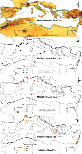
In this work, the “Mediterranean” is considered as any catchment falling within one of the above-mentioned boundaries and defined by authors as Mediterranean, but excluding the administrative boundaries from this assumption (–)
2.2 Physical characteristics of the Mediterranean region
The Mediterranean region has a total area of approximately 1 100 000 km2 (Grove and Rackham Citation2001). Mountain ranges surround the Mediterranean Sea (): the Pyrenees in southwestern Europe, the Alps in southern France and northwestern Italy, the Apennines along the Italian coast, the Dinaric Alps along the coast of the Adriatic Sea, the mountains of Greece, the Taurus Mountains in Turkey, Mount Lebanon in the eastern Mediterranean and the Atlas Mountains in northern Africa. The proximity of the mountain ranges to the sea explains why a majority of the Mediterranean catchments are medium-sized and sloping. Lower hills, such as the Cevennes region in France, and plains also exist along the coasts and in some interior regions; thus, the landscape is quite heterogeneous.
Most of the underlying geology comprises limestone with sandstone, sedimentary deposits and metamorphic granites (Di Castri Citation1981). The prevalence of limestone rocks means that karstic catchments are very common in the region.
Vegetation is mainly dominated by evergreen trees and shrubs (the famous Mediterranean “Maquia” or “Garrigue”). In mountainous areas with wetter conditions, several deciduous tree species prevail. Conversely, the driest areas are dominated by steppe (Bonada and Resh Citation2013). However, Mediterranean catchments exhibit a particular relief-driven organization in the distribution of land types. Hence, forests grow directly under the rocky summits of Mediterranean mountains; agricultural terraces are found downslope. Further down, the Mediterranean Garrigue is present. Finally, agriculture dominates the coastal plains. This pattern is partly attributed to past human activities, but it is now disturbed by the intense urbanization on Mediterranean coastal plains and the abandonment of the agricultural terraces for Mediterranean forests, particularly in Europe (e.g. Gallart and Llorens Citation2004, Lana-Renault et al. Citation2007, Ceballos-Barbancho et al. Citation2008, Moran-Tejeda et al. Citation2010). These changes certainly have an impact on the hydrological responses of Mediterranean catchments.
3 Review extent and database
3.1 Meta-analysis information
A total of 140 studies on the Mediterranean region published over the past two decades were analysed.
To study regional tendencies in the Mediterranean zone, the study region was divided into:
the northwestern Mediterranean (NWM), encompassing Mediterranean Albania, Croatia, France, Italy, Mon-tenegro, Portugal, Slovenia and Spain, with 84 analysed studies;
the eastern Mediterranean (EM), encompassing Cyprus, Egypt, Greece, Israel, Lebanon, Palestinian territories, Syria and Turkey (42 studies);
the southern Mediterranean (SM), encompassing Algeria, Egypt, Libya, Morocco and Tunisia (14 studies).
These studies were divided into three groups focusing on the annual water balance (58 studies), flood events (49 studies) and droughts (33 studies).
For each study, the key information that was systematically collected and analysed includes:
basin location (reference and coordinates);
study objectives;
basin characteristics, such as the area, mean elevation, mean slope, land use, soil classes, geology and the possible presence of karst;
hydro-meteorological data characteristics, such as rainfall–runoff measurement period, time step of the measurements, mean annual precipitation, reference evapotranspiration, mean annual runoff, runoff coefficient and snow contribution; for event-based studies, detailed information on catchment responses (rainfall, runoff, peak discharge) for each event was also extracted when available;
model characteristics, such as the model name and original reference, the simulated hydrological processes, the spatial resolution (lumped, semi-distributed or distributed), the time step and the model evaluation criteria.
3.2 Annual water balance studies
The reviewed studies () with information about the components of the water balance equation (40 out of 58) include approximately 139 Mediterranean catchments: 70 catchments in the NWM, 43 in the EM and 26 in the SM (). The majority (27 out of 40) are studies on individual catchments, while only 13 compare two or more catchments. The catchment areas range from 0.35 km2 to 16 000 km2, with a median of 286 km2; 75% of the catchment areas are below 640 km2. Eighteen catchments are karstic, having hydrogeological boundaries that do not necessarily match the topographic boundaries. Snow represents a significant portion of the precipitation for 21 catchments. Thus, it is an essential component in those water balances.
Table 1. Characteristics of the annual water balance studies in Mediterranean catchments. Nc: number of catchments; Ac: catchment area; Zc: catchment mean elevation; Period: period or number of years used to calculate the water balance components.
3.3 Rainfall–runoff event-based studies
Among the 49 flood studies, 21 include useful information for quantitative analysis on 136 catchments and 191 events ( and ).
Table 2. Summary information of the flood studies in (c). Nc: number of catchments; Ne: number of events; Ac: catchment area; X: data available, –: data not available.
The analysis was conducted only on hydrological studies at the catchment scale. Hence, studies focusing on the hydraulic aspects of the catchment response at the reach scale were excluded. These studies are not limited to extreme flood events (such as Marchi et al. Citation2010, Tarolli et al. Citation2012) but comprise any runoff-generating rainfall event study that contains substantial event-related information. However, this information is not equally available for all. Details on each study and event-related data are presented in . Here, one must clarify that a single event can affect more than one catchment and that more than one event could be reported for the same catchment. Among these studies, 13 were conducted in the NWM, 5 in the EM, and 3 in the SM. One study (Tarolli et al. Citation2012) was an analysis of flash flood regimes in the NWM (France, Spain, Italy) and the EM (Israel). Moreover, 69 catchments out of a total of 136 are located in the NWM. The rest of the catchments are divided between the EM (22) and SM (45). The catchment areas range from 3.83 km2 for the Valsecure catchment (a headwater catchment of the Gardon d’Anduze, southern France; Tramblay et al. Citation2010) to 16 330 km2 for the Negada catchment at Lassoud in Tunisia (Abida and Ellouze Citation2008).
3.4 Drought studies
Drought definitions vary according to the variables used to describe the phenomenon (Mishra and Singh Citation2010, Citation2011). Generally, one can define three major types of droughts: meteorological or climatic drought; agro-meteorological or agricultural drought; and hydrological drought (Gumbel Citation1963, Palmer Citation1968).
Socioeconomic impacts of droughts are defined in terms of losses from an average or expected return and are measured by both social and economic indicators (Mishra and Singh Citation2010). All these droughts aspects are interrelated and are measured in terms of their intensities, durations and frequencies. In this work, we cite recent studies in the Mediterranean region that characterize droughts, and we discuss the main objectives and methods used ().
Droughts are usually studied in a regional context due to their large-scale characteristics (Mishra and Singh Citation2010). Here, 33 drought-related studies published in the past decade in the Mediterranean region are presented ( and ). Eighteen studies were conducted at the catchment scale, while the others had a greater spatial extension, generally an entire country or geographical region. Approximately half of the studies were conducted in the NWM, with a majority (10 articles) in the Iberian Peninsula (mostly Spain), 13 studies were conducted in the EM and only four were conducted in the SM sub-region. Drought studies are usually conducted at long time scales (several decades).
Table 3. Summary of information on the chosen droughts studies in (d). Nc: number of catchments.
4 Hydrological response characteristics
In this section we analyse the hydrological response characteristics of the studied Mediterranean catchments based on the collected data described above, in terms of annual water balance, rainfall–runoff events and drought.
4.1 Annual water balance studies
The mean annual precipitation (MAP), reference evapotranspiration (ET0), and mean annual runoff (MAQ) are highly variable across the three Mediterranean sub-regions. The median values show decreasing MAP, MAQ, MAQ/MAP and an increasing ET0 from NWM to EM and SM ().
Table 4. Summary statistics of climatic and hydrological variables for the studied catchments ( and (b)) for the three Mediterranean sub-regions (NWM, EM and SM). MAP: mean annual precipitation; ET0: reference evapotranspiration; MAQ: mean annual runoff.
The relationship between MAQ and MAP, both expressed in terms of water depth (mm), is plotted, where each point represents a studied catchment (). The results show a significant correlation (R2 = 0.687) between MAQ and MAP reported in all studies. Most low-yielding catchments, with MAP values lower than 400 mm, are located in the SM. For larger MAP, the graph shows important scattering. We remark that that even for large MAP values (up to 900 mm), the runoff yield can be very low (approximately 30 mm); this is true for catchments with highly permeable backgrounds, e.g. in Crete (Koutroulis et al. Citation2013). Thus, the catchment yield is highly variable. The trend for the EM and the NWM catchments is quite similar, with an intercept close to 500–550 mm and comparable slopes. The trend is different for the SM catchments, with an intercept close to 250–300 mm and a lower slope. For a few catchments (especially in the NWM and EM), MAQ is larger than MAP. Here, two factors may explain this phenomenon: the contribution of snow amounts in mountainous catchments, which is underestimated, and the presence of karst, which may greatly increase the effective catchment area.
Figure 2. Relationship between mean annual runoff (MAQ) and mean annual precipitation (MAP) for the three studied sub-regions (NWM, EM and SM). Filled symbols indicate karstic catchments in each sub-region.
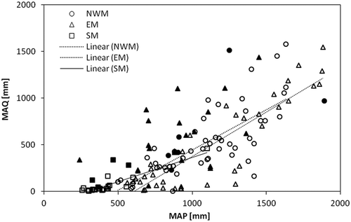
A similar analysis (not shown) that accounted for catchment area and elevation was undertaken. The catchment area does not appear to influence its response. The impact of elevation, however, could not be neglected because it was found that both the MAP and catchment runoff increase with elevation.
To investigate the climatic features of Mediterranean catchments, we provide a Budyko-type plot (Budyko Citation1974, Andréassian and Perrin Citation2012) that shows the mean annual runoff coefficient MAQ/MAP as function of the aridity index AI = ET0/MAP (). When ET0/MAP < 1, wet conditions prevail, otherwise dry climatic conditions prevail. The lines MAQ/MAP = 1 and MAP = MAQ + ET0 represent the water and energy limits. Catchments are expected to fall within these limits for a closed water balance. Otherwise, the catchment is either gaining (catchment with MAQ/MAP > 1) or losing (catchment with MAP < MAQ + ET0) water, or there might be errors in the data. Four catchments fall outside the water or energy limits. These catchments are karstic (e.g. Longobardi and Vallini Citation2008, [Italy], Nikolaidis et al. Citation2013, [Greece]), which may explain the presence of underground water gain or loss processes. Most catchments (60%) can be considered water-stressed, with an aridity index greater than 1.
Figure 3. Plot of mass balance data from the study catchments on a Budyko diagram: mean annual runoff coefficient MAQ/MAP function of the aridity index ET0/MAP. MAP: mean annual precipitation; MAQ: mean annual runoff; ET0: mean annual reference evapotranspiration for the three sub-regions NWM, EM and SM; Filled symbols indicate karstic catchments in each sub-region.
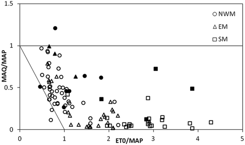
shows a geographical cluster of catchments: (i) NWM catchments with the lowest aridity index and a large variation in catchment water yields (MAQ/MAP); (ii) SM catchments with the lowest runoff yields; (iii) EM catchments with large variations in both aridity index and catchment water yields. This large heterogeneity in the climatic features and hydrological responses of EM catchments can be explained by the complex geomorphologic features of this sub-region and the prevalence of karstic and mountainous catchments.
To summarize, Mediterranean catchments exhibit high variability in terms of both climatic characteristics and catchment hydrological responses at the annual scale. The latter can vary greatly, even for the same amount of rainfall input, which may seriously challenge any modelling approach. Nevertheless, some regional patterns exist, and catchments in each of the above-mentioned sub-regions appear to have somewhat similar characteristics.
4.2 Rainfall-runoff event-based studies
4.2.1 Rainfall events: amount and duration
The monthly distribution of the number of rainfall events per geographic zone is presented in . In the NWM, these occur mostly in autumn (September to December), whilst in the EM, rainfall events occur mostly in winter (January and February). For the SM, most of the studied events occur between September and February, with the highest frequency in January.
Figure 4. Monthly distribution of events per geographic sub-region.

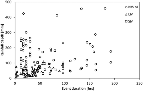
For the 191 events presented here, the duration of the flood runoff generated by an intense rainfall event varies greatly between 2 h and 8 days. Similarly, event rainfall amounts show great variability, from 10.4 mm in the Giofyros Basin, Greece (Koutroulis and Tsanis Citation2010), to 540 mm in the Gard River basin, France (Vincendon et al. Citation2010) over various durations. More extreme events were also reported in the literature, particularly in southern France. On 12–13 November 1999, the Aude River (southern France) witnessed an extreme flood event generated by 700 mm of rainfall in 24 hrs (Gaume et al. Citation2004). The famous 8–9 September 2002 flood in the Gard region (southern France) was generated by approximately 600 mm of rainfall in 48 hours.
represents the cumulative event rainfall as a function of event duration, with large scattering in the relationship. For the same event duration, the total amount of cumulative rainfall can vary greatly over a location. Moreover, the rainfall amounts during a single event vary according to the geographical location, with the highest event rainfall (>100 mm) located in the NWM.
Figure 5. Relationship between rainfall depth and event duration for the studied events over the three studied sub-regions (NWM, EM and SM).
4.2.2 Peak discharge
Event peak discharge is widely used as an indicator of the hydrological response of catchments. Here, we represent the catchment unit peak discharge (the peak discharge per km2) as function of catchment area () and cumulative event rainfall (). Numerous studies found a dependence of peak discharge on catchment area (e.g. Herschy Citation2002, Furey and Gupta Citation2005, Marchi et al. Citation2010, Herschy and Fairbridge Citation1998). represents a log-log diagram of the unit peak discharges of our catchment database (for each catchment, the highest peak flow was plotted) with two envelope curves developed by Tarolli et al. (Citation2012) for the NWM (France, Italy and Spain) and for EM (Israel) flash floods.
Figure 6. Relationship between unit peak discharge and (a) catchment area, (b) rainfall depth and (c) event duration.
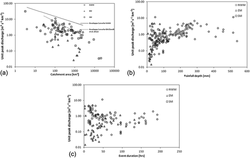
In Mediterranean catchments, unit peak discharges are extremely high. Indeed, values estimated from post-flooding investigations (Gaume et al. Citation2003a, Citation2004, Gaume and Bouvier Citation2004) reached 30 m3 s−1 km−2 for the 8–9 September 2002 event for a 15 km2 basin, exceeded 15 m3 s−1 km−2 in four basins, and exceeded 10 m3 s−1 km−2 in six other basins. This finding can be linked to the characterization of extreme flash floods in 60 catchments of five European climate zones (Mediterranean, Alpine-Mediterranean, Alpine, Continental and Oceanic) presented by Marchi et al. (Citation2010). The authors found the highest unit peak flows in the Mediterranean region followed by the Alpine-Mediterranean.
In our dataset, the highest unit peak flow was recorded on the Alzon River at Saint-Jean-du-Pin, southern France (Nguyen et al. Citation2014), with a value of 33 m3 s−1 km−2 (catchment area of 30 km2). However, the unit peak discharges decrease rapidly with increasing catchment area. This rapid decrease in unit peak discharge with an increase in catchment area may reflect the high spatial variability in the rainfall events that occurs in the Mediterranean and the high heterogeneity in the hydrological responses of different locations within a catchment (Latron and Gallart Citation2007, Citation2008). Thus, for a given catchment and a given rainfall event, the event does not necessarily affect the entire catchment, and the runoff-generating processes are not the same in all parts of the catchment.
The differences in catchment responses in terms of unit peak discharges by geographical location are illustrated in . The figure clearly shows that the highest peak discharges are recorded in the NWM, followed by the SM. The lowest unit peak flows were recorded in the EM. The highest unit peak flows were recorded for the smallest catchments. For large catchments, values from the NWM and SM catchments are within the same range, whereas the EM records the lowest values. Nevertheless, although the NWM is known for severe rainfall events and catastrophic floods, the highest peak flows may be partly attributed to the relatively denser gauging networks and larger number of research teams investigating post-flood conditions in that sub-region. Hence, information on peak flows in small catchments (on the order of 10 km2) is available. This information is rarely available for other areas of the Mediterranean.
Unit peak discharges as a function of rainfall depth () are highly scattered for a given amount of cumulative rainfall. Therefore, no correlation could be found between event rainfall depth and event peak flow, particularly for rainfall depths below 100 mm. However, above a 100 mm rainfall threshold, the unit peak discharge seems to increase continuously with the amount of event rainfall.
Another factor that may influence peak flow is the duration of the rainfall event. It is tempting to associate a longer event with a higher unit peak discharge. While this might be the case in humid environments, no obvious relationship exists in Mediterranean catchments. For a given event duration, the unit peak discharges vary greatly (). However, this relationship is true for relatively short events (event durations of less than 50 h), whilst it seems from the analysis of that, for longer event durations, a particular pattern exists: the unit peak discharge appears to increase with increasing event duration. A plausible explanation is that, for very long events, the catchment moisture conditions and runoff generation processes begin to resemble those of humid conditions. In fact, during the wet season, Mediterranean catchments may function similarly to catchments in humid climates (Latron et al. Citation2009, Gallart et al. Citation2011).
4.2.3 Runoff ratio
A very important concept for assessing the catchment hydrological response is the event runoff ratio, which is defined as the ratio of event runoff volume to event rainfall volume. presents the runoff depth ()) and the runoff ratio ()) as functions of cumulative event rainfall. There is clear scattering in the response. Thus, for a given rainfall depth, both the runoff and runoff ratio may greatly vary.
Figure 7. Relationship between (a) runoff depth and rainfall depth, and (b) runoff ratio and rainfall depth.
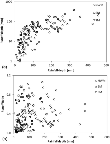
In Mediterranean catchments, event runoff ratios vary over a large range ()). For instance, the ratio varies from 0.01 in the Rafina catchment (Greece; Massari et al. Citation2014) to 1.2 in the Lez catchment (France; Coustau et al. Citation2012). The mean value of the sample we studied was 0.37, with a standard deviation of 0.27. The median was 0.30, and the interquartile range was 0.14–0.51. There are geographical discrepancies in the catchment responses to rainfall events. shows that the highest runoff depths and runoff ratios appear in the NWM catchments. In fact, the median runoff ratios vary between sub-regions, e.g. from 0.40 in the NWM (similar to the values found by Marchi et al. Citation2010) to 0.36 in the SM and only 0.12 for EM catchments. It is also obvious that, for low rainfall depths (particularly below 50 mm), all events are from the EM and SM, which may exhibit very high runoff ratios, despite the amount of rainfall depth.
Extremely high runoff ratios are recorded for some events, and they may exceed unity. This finding can be explained by the karstic nature of the catchment, with a runoff-generating area that is much larger than the topographic basin. One example is the Lez catchment in France (Coustau et al. Citation2012). High runoff ratios were also estimated for other catchments, such as Merhavia in Israel (Rozalis et al. Citation2010), the Reno River in Italy (Brath et al. Citation2004) and Mdouar in Morocco (Tramblay et al. Citation2012). Here, the events triggering such high runoff ratios usually occur after other large events. Thus, the initial moisture conditions influence the generation of important runoff amounts. These physical characteristics of the Mediterranean and the high seasonality of the climatic features may explain the large scattering in the catchment responses, both in terms of event runoff ratios and peak discharges.
The relatively low dependence of the runoff ratio against the cumulative rainfall depth could be explained by many factors. First, under Mediterranean climatic conditions, Hortonian flows are expected to be dominant. Thus, the catchment hydrological response is controlled by rainfall intensity rather than by depth. Moreover, the initial moisture conditions exhibit significant variability, thus triggering different hydrological responses, even with the same amount of rainfall. Furthermore, in Mediterranean catchments, the temporal and spatial distribution of rainfall events, which certainly plays an important role in shaping the catchment response, are highly variable. In addition, the runoff-generating processes along catchments are heterogeneous, and the percentage of the catchment area that actually contributes to runoff can vary by event.
4.3 Drought studies
In contrast to studies on the annual water balance and rainfall–runoff events, similar comparisons for droughts are difficult, because authors do not all use the same variables to quantify droughts. Therefore, our analysis is more qualitative, and our conclusions could appear more subjective.
Climatic trends in the region show an overall decrease in the available water resources due to a reduction in the annual rainfall and an increase in the annual temperature and reference evapotranspiration (Kafle and Bruins Citation2009, Chaouche et al. 2010, Mavromatis and Stathis Citation2011, Vicente-Serrano et al. Citation2014). However, important seasonal discrepancies exist in the evolution of different components of the water balance equation across areas of the Mediterranean. All studies show a high spatial and temporal variability of drought events across the Mediterranean, in the EM, the SM, parts of the Iberian Peninsula, the main islands and southeastern Italy.
Climate change impact projections for the 21st century in the Mediterranean converge towards a drier climate by the end of the century (e.g. Abouabdillah et al. Citation2010, Capra et al. Citation2013, Marquès et al. Citation2013, Ruffault et al. Citation2013, Vrochidou et al. Citation2013). The water management scenarios in different catchments show a large decrease in water availability, particularly during dry periods, due to the pressure of large anthropogenic increase of population in these catchments. However, important disparities can exist within the same catchment.
5 Objectives and methods of hydrological studies
In this section we discuss the objectives that drove existing hydrological studies in the Mediterranean region and the most commonly used modelling approaches for annual water balance, rainfall–runoff events and drought studies. Two main objectives are identified: “simulation” and “scenario testing”. In each case, the available studies are classified by their objectives or models used. This analysis aims to evaluate whether the Mediterranean context requires further specific approaches.
5.1 Annual water balance studies
lists the existing studies that employ continuous-based hydrological models and are classified under two main objectives:
“simulation”: representation of hydrological processes, model performance assessment, model uncertainty assessment, development of new models, streamflow simulation with limited data and karstic zone modelling;
“scenario testing”: assessment of the impacts of different scenarios of land use change (LUC) and climate change (CC) on water resources and erosion.
Table 5. The main objectives and the models used for continuous streamflow simulation studies in the Mediterranean.
Apart from classical objectives, such as assessing model performance, improving model predictability or developing and testing new models, continuous streamflow simulation studies in the Mediterranean region focus on the impact of global change on hydrological responses. Mediterranean environments are water stressed, and demands on water are increasing because of the increasing population and tourist industry. Moreover, the Mediterranean region is prone to climate change (IPCC Citation2014), and many studies have projected an increase in temperature and a decrease in precipitation over the Mediterranean Basin (Alpert et al. Citation2002, Philandras et al. Citation2011, IPCC Citation2014). Other studies addressed crucial features of Mediterranean environments, such as erosion (e.g. Raclot and Albergel Citation2006, Lesschen et al. Citation2009, Shakesby Citation2011, Garcia-Ruiz et al. Citation2013) and karstic influences (e.g. Coustau et al. Citation2012, Doglioni et al. Citation2012, Touhami et al. Citation2013).
illustrates how the same hydrological model was used for different objectives (e.g. SWAT [Soil and Water Assessment Tool] or Génie Rural model). However, some models were developed for a specific purpose: the HYdrological Land Use Change model (HYLUC) (Delgado et al. Citation2010) was used to evaluate the impact of land use change on catchment hydrological responses; the HYdrological Modelling for Karst Environment (HYMKE) (Rimmer and Salingar Citation2006) and 3D Karstic Flow Model (3dkflow) (Rozos and Koutsoyiannis Citation2006) were built and used for hydrological simulations in karstic catchments; and HYDROGEIOS, which is a semi-distributed model for streamflow simulation in human-modified basins (Efstratiadis et al. Citation2008).
The model choice seems to depend on data availability, the experience of the researcher (especially in terms of computing experience), and the available funding (some models are expensive). Except for some specific cases (e.g. Delgado et al. Citation2010 [Spain], Rozos and Koutsoyiannis Citation2006, Kourgialas et al. Citation2010 [Greece], Rimmer and Salingar Citation2006 [Israel]), the objective of the study does not necessarily influence the model choice. These claims are more obvious when we evaluate the geographical distribution of the models in use. Indeed, complex and data-demanding models appear to be primarily in use in the Euro-Mediterranean part of the region and in Israel. Most models were applied in other climatic contexts.
5.2 Rainfall–runoff event-based studies
Similarly to water balance studies, the two main objectives of rainfall–runoff event-based studies include (see detailed list in ):
“simulation”: similar objectives, with greater emphasis on runoff generation processes, wetness impacts on catchment responses and flash flood estimations, and sensitivity of model performance to data and parameters;
“scenario testing”: similar objectives on LUC and CC impact assessment, as well as wildfire impact or flood risk mitigation.
Table 6. The main objectives and models used for event-based studies in the Mediterranean.
Regarding event-based studies, the same model can be used for different objectives. These are classical models that are applied worldwide. There have been only a few attempts to develop models specifically for the Mediterranean environment (e.g. Manus et al. Citation2009, Nunes and Seixas Citation2011, Roux et al. Citation2011, Massari et al. Citation2015). Some authors slightly modified available models to account for specific features of the Mediterranean (e.g. Rozalis et al. Citation2010).
Modelling the hydrological response of Mediterranean catchments, particularly at the event level, using classical modelling techniques is somewhat controversial. In fact, the results from various studies characterizing hydrological responses of these catchments and runoff-generation mechanisms show that, under Mediterranean conditions, runoff-generation mechanisms and catchment responses are heterogeneous. Hence, the most important rainfall events in terms of precipitation volume are not necessarily those with the highest runoff ratio or peak flow (Moussa and Chahinian Citation2009, Marchi et al. Citation2010, Tarolli et al. Citation2012), and different mechanisms can co-exist (Manus et al. Citation2009). Furthermore, different parts of the catchments can exhibit different runoff-generation processes, while some parts of the basin may not contribute at all (Latron and Gallart Citation2007). Catchment responses also depend on the initial wetness conditions, and they fluctuate greatly between seasons (Lana-Renault et al. Citation2007, Maneta et al. Citation2007, Huza et al. Citation2014). However, because of the high intensity of rainfall under Mediterranean conditions, infiltration excess is often dominant (Manus et al. Citation2009). The impact of high-intensity rainfall is particularly important for extreme events, where it becomes the sole factor that influences runoff generation (Brath and Montanari Citation2000, Lana-Renault et al. Citation2011). Nevertheless, this is not true for all Mediterranean catchments. A recent study by Efstratiadis et al. (Citation2014), who analysed several flood events in small catchments in Greece and Cyprus, highlighted that the key component of flood runoff is interflow, not overland flow. The authors also demonstrated that the initial soil moisture conditions drastically influence the basin response (which is a common conclusion of all studies in the Mediterranean).
Some of the most commonly used models (SCS-CN) are threshold models, in which a portion of the precipitation is used to fill soil water content before generating runoff. Other models developed for more humid climates (e.g. based on TOPMODEL) use saturation excess mechanisms to generate runoff. The limitation of TOPMODEL for Mediterranean catchments was demonstrated by Gallart et al. (Citation2007) in the Vallecebre catchment in Spain. TOPMODEL simulates the hydrological response well in the wet season. However, under dry conditions, the model performance decreases. Moreover, Mediterranean catchment responses at the event scale are very sensitive to the spatial and temporal (within-storm) variation of rainfall (Rozalis et al. Citation2010). High spatio-temporal resolution rainfall data, which are not available in many parts of the Mediterranean, particularly in North Africa and the Near East, are needed.
5.3 Drought studies
For the existing drought studies (see detailed list in ), the two main objectives include:
“simulation”: characterization of the temporal and spatial variations of droughts and the methods for drought assessment;
“scenario testing”: assessment of the impact of different scenarios (climatic, anthropogenic, etc.) on drought characteristics in a catchment or region.
Table 7. The main objectives and methods used for the chosen drought studies in the Mediterranean.
The methods used are also presented in . A description of the different drought indices and their definitions are available in drought reviews (e.g. Mishra and Singh Citation2010, Citation2011).
Precipitation-based indices, such as the standardized precipitation index (SPI) and modified versions of this are the most popular among meteorological-based indices. These indices are globally relevant and are applicable at different time scales to characterize short- and long-term droughts and their impacts on different components of the water balance. Hence, one should emphasize the importance of the choice of time scale of analysis (Vicente-Serrano and López-Moreno Citation2005). The objective of the index (impact on surface water, reservoirs, etc.) should constrain the choice of the time step.
Hydrological indices, such as the Palmer index (e.g. Vasiliades and Loukas Citation2009), indices related to soil moisture (Vidal et al. Citation2012) and groundwater indices (Mendicino et al. Citation2008), have also been used. Agricultural drought indices are also prevalent in the Mediterranean literature (Diodato and Bellocchi Citation2008).
The models used in drought studies are mainly water management models, such as the Water Evaluation and Planning system (WEAP) (Yilmaz and Harmancioglu Citation2010, Hamlat et al. Citation2012) and the inVEST model (Marquès et al. Citation2013, Terrado et al. Citation2014), or simple water balance models, e.g. the SIERRA model (Ruffault et al. Citation2013).
Moreover, climatic trend analyses are also commonly used to assess the impact of temporal and spatial drought variations.
In summary, various methods are used for drought characterization in the Mediterranean region. However, meteorological-based indices, such as the SPI, remain the most popular. Moreover, the main concerns that drive drought studies appear to be global change impacts due to climatic and anthropogenic pressures.
6 Discussion and perspectives
Sections 4 and 5 presented an overview of the recent studies in the Mediterranean in terms of hydrological response characteristics and modelling approaches at different time scales, in the context of annual runoff, flood and drought studies. This section discusses the main results and provides complementary responses to the three questions posed in the introduction.
6.1 Can we identify regional patterns in the Mediterranean?
Comparison of catchments in different Mediterranean areas shows that some regional tendencies exist. In terms of the annual water balance, catchments from the NWM have higher humidity, relatively low dryness index and higher annual runoff yields. These findings could be due to the influence of the humidity from the Atlantic Ocean, which modifies the seasonal pattern of rainfall, i.e. less precipitation in winter and a rainfall peak in autumn and/or spring (McNeill Citation1992). SM catchments are the driest, with the highest aridity index and lowest annual runoff yields. The EM proves to be more heterogeneous, with a relatively wide range of values in terms of both aridity index and runoff yields (e.g. Rimmer and Salingar Citation2006, Tzoraki and Nikolaidis Citation2007, Kourgialas et al. Citation2010).
Regional tendencies also exist in the seasonal distribution and severity of extreme rainfall events. In fact, rainfall events in the NWM occur mostly in autumn, with a peak in September. Rainfall in the EM sub-region occurs mostly in winter, with a peak in January and February. In the SM, the sample is too small to generalize. Moreover, in terms of the event rainfall depth, peak discharges and runoff ratios, the highest values occur in the NWM. Similar findings have been reported by other authors who studied floods in the Mediterranean region (Marchi et al. Citation2010, Tarolli et al. Citation2012, Llasat et al. Citation2013). In fact, the NWM sub-region exhibits extreme rainfall regimes, with rainfall commonly exceeding 200 mm in 24 hours. Cortesi et al. (Citation2012) studied the distribution of the daily precipitation concentration index across Europe. The highest values were computed for the coastal arc that extends from southeastern Spain to Sicily (Italy). Moreover, Reiser and Kutiel (Citation2011) compared the rainfall regimes in Valencia (Spain) and Larnaca (Cyprus). The authors found that in Valencia the rainfall regimes are more extreme than in Larnaca. Hence, in the NWM, daily rainfall values that exceed 600 mm have been recorded.
However, there is also overlap between morphometric and hydrological characteristics of particular catchments located in different sub-regions, particularly between the NWM and EM. These similarities between catchments can highlight the existence of twin basins (e.g. basins with similar physiographic features and/or hydrological responses), for which hydrological responses can be transferred from gauged to ungauged basins.
6.2 What is required to model Mediterranean catchments?
A distinction can be made between continuous streamflow simulations and event-based simulations. The former are usually applied to quantify water resources in the catchment of interest, assess land cover and/or climate change impacts, or test new modelling approaches. In event-based studies, the objectives may vary from flood risk mitigation to understanding flood-triggering characteristics. For continuous streamflow simulations, daily meteorological and hydrological data are used most often (sometimes monthly data). The applied models are often lumped conceptually, with relatively good results. Nevertheless, how to model the catchment response at the event scale is a dilemma. The high rainfall intensity and spatial variability within a storm, along with a catchment’s initial wetness conditions, complicate this task. Classical hydrological models are not well suited to the Mediterranean area. In fact, many of these models assume precipitation abstraction (such as the widely used SCS-CN) or saturated excess mechanisms (such as the TOPMODEL family), which is not necessarily the case in the Mediterranean. Moreover, any suitable modelling approach for these catchments is highly demanding in terms of data. Hence, to account for the variability in the rainfall intensity in a short time, the model should be applied at the hourly (or shorter) scale for flood studies. Furthermore, the model should be able to account for any rainfall spatial variability and catchment wetness conditions. Therefore, information on soil properties and soil moisture conditions is needed.
The specificities of the Mediterranean catchment responses explain the large response heterogeneity in the region and emphasise the fact that modelling the hydrological behaviour of Mediterranean catchments is difficult (Oudin et al. Citation2008). In regional studies that involve catchments from Mediterranean and non-Mediterranean (humid) regions, such as in Goswami et al. (Citation2007) and Oudin et al. (Citation2008, Citation2010), the performance of the model-dependent regional approaches is worse in the Mediterranean climate. High-resolution spatial and temporal rainfall and soil properties and moisture data may be necessary to accurately simulate the hydrological behaviour of Mediterranean catchments. However, such data are rarely available. Consequently, detailed flood studies are usually performed in small research catchments, with results that are often difficult to generalize in space and time (Gallart et al. Citation2007, Lana-Renault et al. Citation2007, Latron and Gallart Citation2007, Manus et al. Citation2009, Rozalis et al. Citation2010, Molina et al. Citation2014). This finding also explains why studies in large catchments are usually limited to flood risk mitigation or peak flow estimation, sometimes using lumped methods only.
To overcome the difficulties in modelling hydrological responses of Mediterranean catchments, particularly in terms of accounting for the high spatial variability of model parameters, radar rainfall, spatial soil moisture information and remote sensing data are considered (Rozalis et al. Citation2010, Tramblay et al. Citation2010, Citation2012, Massari et al. Citation2015). New approaches that couple observations (usually obtained on small catchments) and modelling are used to improve our understanding of flood-triggering processes. For example, recent work was undertaken within the HyMeX project on two French catchments (Braud et al. Citation2014). This is a multi-scale approach that assesses the runoff-generation processes from observations at a small hillslope scale. The rainfall variability and soil moisture, along with the network organization, were studied for medium-sized catchments (1–100 km2) and for river routing and flooding at a large scale (100–1000 km2). Data analyses were coupled to modelling techniques, and the results are promising. However, these approaches are very demanding in terms of instrumentation, data, computational effort and, consequently, financial resources. Thus, the majority of flood simulation studies in the Mediterranean are concentrated in the developed countries of the Euro-Mediterranean region and Israel.
6.3 What are the main challenges for future research in the Mediterranean?
In recent decades, we have observed an important change in the scope of hydrological studies in the Mediterranean zone and consequently in the expected performance of hydrological modelling. Currently, there remains an important need for research on classical rainfall–runoff hydrological modelling for engineering applications in water resources management, water supply infrastructure design, flood and drought prediction, pollution projections and erosion processes. However, hydrological modelling has become an indispensable tool for many interdisciplinary projects in the Mediterranean. For example, anthropogenic and climatic change impacts on environmental variables can be assessed. Modelling is data intensive, and improving model performances involves the acquisition of new data at various spatio-temporal scales. Future research challenges in Mediterranean hydrology include:
Strengthening hydrological knowledge, with an emphasis on the EM and SM areas. While the NWM areas are well studied, there is an urgent need to conduct more hydrological studies in the EM and SM, from plot to large catchment scales and from short time scales (a few minutes for flash flood genesis on hillslopes) to decades (impacts of land use and climate change).
Improving measurements and data availability. There is a need to improve current measuring infrastructure, since the current data are not satisfactory for studies associated with extreme flash flood events, drought periods (absence of flow) and long-term land use and climate change. These data can be obtained through the installation of long-term environmental stations, in order to establish dense precipitation and streamflow gauging networks. Radar data and remote sensing approaches are also promising options, as complementary to surface observations.
Conducting large-scale studies under Mediterranean conditions. There is a need to lead studies at the scale of the entire Mediterranean region (e.g. Iglesias et al. Citation2007, Chenoweth et al. Citation2011, Garcia-Ruiz et al. Citation2011, Milano et al. Citation2013, among others). This would require setting up large datasets through scanning and digitizing old records, historical data and previous studies. Thus, the currently established database initiated in this work could be extended to Mediterranean-type basins that are found worldwide (e.g. Mediterranean zones in Australia, California, Chile and South Africa), for an overall comparative study. This comparison would provide a common basis for understanding the hydrological behaviour of catchments and improving regionalization approaches. In terms of hydrological modelling, models already applied at continental scales (e.g. EFAS [http://floods.jrc.ec.europa.eu/lisflood-model.html], E-hype [http://e-hypeweb.smhi.se/]) would be good candidates to conduct modelling studies at the Mediterranean scale.
Studying the Mediterranean under change. Transferring the results between “similar” Mediterranean catchments could also be useful for predicting the effects of climate change or land use change on the hydrological response, following the objectives of the decadal “Panta Rei” (2013–2022) of the International Association of Hydrological Sciences (IAHS) (Hrachowitz et al. Citation2013).
Improving hydrological modelling on small catchments. Theoretical developments are needed, and classical models must be adapted by taking into account the representation of the main hydrological processes. In large catchments (>500 km2), spatial rainfall and hydrographs are smoothed at the daily scale. Consequently, conventional hydrological models perform well and therefore remain well suited for understanding hydrological processes, testing hypotheses or simulating missing discharge data series. However, when moving to small catchments (<100 km2), many hydrological processes remain poorly represented or neglected in classical models, e.g. threshold functioning for runoff genesis and transfer on hillslopes and through the channel network (e.g. the cases of ephemeral and intermittent flows), the importance of flow in non-saturated zones, and the difficulties in modelling surface–subsurface interactions in dryland regions.
Accounting for variabilities. New “tailor-made” models (i.e. models based on measures) need to be developed to consider specific spatio-temporal heterogeneities of catchment responses in areas with specific hydrological functions, such as in karstic, urban and peri-urban zones.
We believe that reviews at large regional scales, such as the one presented here, are essential for advancing our understanding of hydrological behaviour of highly complex areas, such as the Mediterranean region, in terms of comparative hydrology. This review is an attempt to strengthen the research initiatives at this scale.
Acknowledgements
The authors thank the two reviewers, Juan Ignacio López-Moreno and Luca Brocca, and Associate Editor Andreas Efstratiadis for their useful comments, which helped to improve the overall quality of the manuscript.
Disclosure statement
No potential conflict of interest was reported by the authors.
Additional information
Funding
Related Research Data
References
- Abida, H. and Ellouze, M., 2008. Probability distribution of flood flows in Tunisia. Hydrology and Earth System Sciences, 12, 703–714. Retrieved from www.hydrol-earth-syst-sci.net/12/703/2008/
- Abouabdillah, A., et al., 2010, Modeling the impact of climate change in a Mediterranean catchment (Merguellil, Tunisia). Fresenius Environmental Bulletin, 19 (10a), 2334–2347.
- Adamovic, M., et al., 2015. Assessing the simple dynamical systems approach in a Mediterranean context: application to the Ardèche catchment (France). Hydrology and Earth System Sciences, 19, 2427–2449. doi:10.5194/hess-19-2427-2015
- Albek, M., Ogutveren, U.B., and Albek, E., 2004. Hydrological modeling of Seydi Suyu watershed (Turkey) with HSPF. Journal of Hydrology, 285, 260–271. doi:10.1016/j.jhydrol.2003.09.002
- Alpert, P., et al., 2002. The paradoxical increase of Mediterranean extreme daily rainfall in spite of decrease in total values. Geophysical Research Letters, 29 (10). doi:10.1029/2001GL013554
- Alpert, P., et al., 2008. Climatic trends to extremes employing regional modeling and statistical interpretation over the E. Mediterranean. Global and Planetary Change, 63, 163–170. doi:10.1016/j.gloplacha.2008.03.003
- Amengual, A., et al., 2006. A hydrometeorological modeling study of a flash-flood event over Catalonia, Spain. Journal of Hydrometeorology, 8, 282–303. doi:10.1175/JHM577.1
- Andréassian, V. and Perrin, C. 2012. On the ambiguous interpretation of the Turc-Budyko nondimensional graph. Water Resources Researcher, 48, W10601.
- Artigue, G., et al., 2012. Flash flood forecasting in poorly gauged basins using neural networks: case study of the Gardon de Mialet basin (southern France). Natural Hazards and Earth System Sciences, 12, 3307–3324. doi:10.5194/nhess-12-3307-2012
- Aviad, Y., Kutiel, H., and Lavee, H., 2009. Variation of dry days since last rain (DDSLR) as a measure of dryness along a Mediterranean–Arid transect. Journal of Arid Environments, 73, 658–665. doi:10.1016/j.jaridenv.2009.01.012
- Bakreti, A., et al., 2013, Analyse conjointe des régimes pluviométriques et hydrologiques dans le bassin de la Tafna (Algérie Occidentale). Hydrological Sciences Journal, 58 (1), 133–151. doi:10.1080/02626667.2012.745080
- Ballesteros-Cánovas, J.A., et al., 2013. An integrated approach to flood risk management: a case study of Navaluenga (Central Spain). Water Resour Manage, 27, 3051–3069. doi:10.1007/s11269-013-0332-1
- Bangash, R., et al., 2012. Water allocation assessment in low flow river under data scarce conditions: A study of hydrological simulation in Mediterranean basin. Science of the Total Environment, 440, 60–71. doi:10.1016/j.scitotenv.2012.08.031
- Benkaci Ali, T. and Dechemi, N., 2004. Modélisation pluie–débit journalière par des modèles conceptuels et ȁ boîte noire; test d’un modèle neuroflou/Daily rainfall–runoff modelling using conceptual and black box models; testing a neuro-fuzzy model. Hydrological Sciences Journal, 49 (5), 919–930. doi:10.1623/hysj.49.5.919.55132
- Bernal, S., et al., 2013. Exploring the long-term response of undisturbed Mediterranean catchments to changes in atmospheric inputs through time series analysis. Science of the Total Environment, 458-460, 535–545. doi:10.1016/j.scitotenv.2013.04.072
- Bloschl, G., et al., 2013. Runoff prediction in ungauged basins: synthesis across processes, places and scales. Cambridge: Cambridge University Press.
- Bonada, N. and Resh, V.H., 2013. Mediterranean-climate streams and rivers: geographically separated but ecologically comparable freshwater systems. Hydrobiologia, 719, 1–29. doi:10.1007/s10750-013-1634-2
- Borga, M., et al., 2007. Hydrometeorological Analysis of the 29 August 2003 flash flood in the eastern Italian Alps. American Meteorological Society, 1049–1067. doi:10.1175/JHM593.1
- Bouabid, R. and Chafai Elalaoui, A., 2010. Impact of climate change on water resources in Morocco: the case of Sebou Basin. In: Economics of drought and drought preparedness in a climate change context. Options Méditerranéennes : Série A. Séminaires Méditerran éen s, n. 95. Zaragoza: CIHEAM/FAO/ICARD A/GD AR /CEIGRAM/MARM.
- Bouraoui, F., et al., 2005. Application of the SWAT model on the Medjerda river basin (Tunisia). Physics and Chemistry of the Earth, Parts A/B/C, 30, 497–507. doi:10.1016/j.pce.2005.07.004
- Brath, A. and Montanari, A., 2000. The effects of the spatial variability of soil infiltration capacity in distributed flood modeling. Hydrological Processes, 14, 2779–2794. doi:10.1002/1099-1085(20001030)14:15<2779::AID-HYP91>3.0.CO;2-X
- Brath, A., Montanari, A., and Toth, E., 2004. Analysis of the effects of different scenarios of historical data availability on the calibration of a spatially-distributed hydrological model. Journal of Hydrology, 291, 232–253. doi:10.1016/j.jhydrol.2003.12.044
- Braud, I., et al., 2014. Multi-scale hydrometeorological observation and modelling for flash flood understanding. Hydrology and Earth System Sciences, 18, 3733–3761. doi:10.5194/hess-18-3733-2014
- Brocca, L., Melone, F., and Moramarco, T., 2008. On the estimation of antecedent wetness conditions in rainfall–runoff modelling. Hydrological Processes, 22, 629–642. doi:10.1002/hyp.6629
- Budyko, M.I., 1974. Climate and life. New York, USA: Academic Press.
- Burlando, P. and Rosso, R., 2002. Effects of transient climate change on basin hydrology. 2. Impacts on runoff variability in the Arno River, central Italy. Hydrological Processes, 16, 1177–1199. doi:10.1002/hyp.1056
- Candela, L., et al., 2012. Modelling impacts of climate change on water resources in ungauged and data-scarce watersheds. Application to the Siurana catchment (NE Spain). Science of the Total Environment, 440, 253–260. doi:10.1016/j.scitotenv.2012.06.062
- Capra, A., Consoli, S., and Scicolone, B., 2013. Long-term climatic variability in calabria and effects on drought and agrometeorological parameters. Water Resources Management, 27, 601–617. doi:10.1007/s11269-012-0204-0
- Ceballos, A. and Schnabel, S., 1998. Hydrological behaviour of a small catchment in the dehesa landuse system (Extremadura, SW Spain). Journal of Hydrology, 210, 146–160. doi:10.1016/S0022-1694(98)00180-2
- Ceballos-Barbancho, A., et al., 2008. Water resources and environmental change in a Mediterranean environment: the south-west sector of the Duero river basin (Spain). Journal of Hydrology, 351, 126–138. doi:10.1016/j.jhydrol.2007.12.004
- Chenoweth, J., et al., 2011. Impact of climate change on the water resources of the eastern Mediterranean and Middle East region: modeled 21st century changes and implications. Water Resources Research, 47 (6). doi:10.1029/2010WR010269
- Collet, L., et al., 2013. Assessing the long-term impact of climatic variability and human activities on the water resources of a meso-scale Mediterranean catchment. Hydrological Sciences Journal, 59 (8), 1457–1469. doi:10.1080/02626667.2013.842073
- Cortesi, N., et al., 2012. Daily precipitation concentration across Europe 1971–2010. Natural Hazards and Earth System Sciences, 12, 2799–2810. doi:10.5194/nhess-12-2799-2012
- Cosandey, C., et al., 2005. The hydrological impact of the mediterranean forest: a review of French research. Journal of Hydrology, 301, 235–249. doi:10.1016/j.jhydrol.2004.06.040
- Coustau, M., et al., 2012. Flood modelling with a distributed event-based parsimonious rainfall-runoff model: case of the karstic Lez river catchment. Natural Hazards Earth Systems Sciences, 12, 1119–1133. doi:10.5194/nhess-12-1119-2012
- Cudennec, C., Leduc, C., and Koutsoyiannis, D., 2007. Dryland hydrology in Mediterranean regions-a review. Hydrological Sciences Journal, 52 (6), 1077–1087. doi:10.1623/hysj.52.6.1077
- D’Agostino, D.R., et al., 2010. Assessing the results of scenarios of climate and land use changes on the hydrology of an italian catchment: modeling study. Hydrological Processes, 24, 2693–2704. doi:10.1002/hyp.7765
- De Girolamo, A.M. and Lo Porto, A., 2011, Land use scenario development as a tool for watershed management within the Rio Mannu Basin. Land Use Policy, 29 (3), 691–701. doi:10.1016/j.landusepol.2011.11.005
- De Jong, C., et al., 2008. A transdisciplinary analysis of water problems in the mountainous karst areas of Morocco. Engineering Geology, 99, 228–238. doi:10.1016/j.enggeo.2007.11.021
- De Waele, J., et al., 2010. Flash flood hydrology in karstic terrain: Flumineddu Canyon, central-east Sardinia. Geomorphology, 120, 162–173. doi:10.1016/j.geomorph.2010.03.021
- Delgado, J., et al., 2010. Modelling the hydrological response of a Mediterranean medium-sized headwater basin subject to land cover change: the Cardener River basin (NE Spain). Journal of Hydrology, 383, 125–134. doi:10.1016/j.jhydrol.2009.07.024
- Di Castri, F., 1981. Mediterranean-type shrublands of the world Vol. 11. Amsterdam: Elsevier.
- Diodato, N. and Bellocchi, G., 2008. Drought stress patterns in Italy using agro-climatic indicators. Climate Research, 36, 53–63. doi:10.3354/cr00726
- Dogan, S., Berktay, A., and Singh, V.P., 2012. Comparison of multi-monthly rainfall-based drought severity indices, with application to semi-arid Konya closed basin, Turkey. Journal of Hydrology, 470-471, 255–268. doi:10.1016/j.jhydrol.2012.09.003
- Doglioni, A., Simeone, V., and Giustolisi, O., 2012. The activation of ephemeral streams in karst catchments of semi-arid regions. Catena, 99, 54–65.
- Dooge, J., Bruen, M., and Parmentier, B., 1999. A simple model for estimating the sensitivity of runoff to long-term changes in precipitation without a change in vegetation. Advances in Water Resources, 23, 153–163.
- Efstratiadis, A., et al., 2014. Flood design recipes vs. reality: can predictions for ungauged basins be trusted? Natural Hazards and Earth System Sciences, 14, 1417–1428. doi:10.5194/nhess-14-1417-2014
- Efstratiadis, A., et al., 2008. HYDROGEIOS: a semi-distributed GIS-based hydrological model for modified river basins. Hydrology and Earth System Sciences, 12, 989–1006. doi:10.5194/hess-12-989-2008
- Esper, J., et al., 2007. Long-term drought severity variations in Morocco. Geophysical Research Letters, 34, 1–5. doi:10.1029/2007GL030844
- Estrany, J., Garcia, C., and Batalla, R.J., 2010. Hydrological response of a small Mediterraean agricultural catchment. Journal of Hydrology, 380, 180–190. doi:10.1016/j.jhydrol.2009.10.035
- FAO., 2006. Global forest resources assessment 2005: report on fires in the Mediterranean region. Fire Management Working Paper, Rome.
- Fiorentino, M., Manfreda, S., and Iacobellis, V., 2007. Peak runoff contributing area as hydrological signature of the probability distribution of floods. Advances in Water Resources, 30, 2123–2134. doi:10.1016/j.advwatres.2006.11.017
- Fox, D.M., et al., 2012. A case study of land cover change (1950e2003) and runoff in a Mediterraean catchment. Applied Geography, 32, 810–821. doi:10.1016/j.apgeog.2011.07.007
- Franchini, M. and Pacciani, M., 1991. Comparative analysis of several conceptual rainfall-runoff models. Journal of Hydrology, 122, 161–219. doi:10.1016/0022-1694(91)90178-K
- Fujihara, Y., et al., 2008. Assessing the impacts of climate change on the water resources of the Seyhan River Basin in Turkey: use of dynamically downscaled data for hydrologic simulations. Journal of Hydrology, 353, 33–48. doi:10.1016/j.jhydrol.2008.01.024
- Furey, P.R. and Gupta, V.K., 2005, Effects of excess rainfall on the temporal variability of observed peak-discharge power laws. Advances in Water Resources Observed Peak-Discharge Power Laws, 28 (11), 1240–1253. doi:10.1016/j.advwatres.2005.03.014
- Gallart, F., et al., 2011. Analysing the effect of global change on the historical trends of water resources in the headwaters of the Llobregat and Ter river basins (Catalonia, Spain). Physics and Chemistry of the Earth, Parts A/B/C, 36, 655–661. doi:10.1016/j.pce.2011.04.009
- Gallart, F., et al., 2007. Using internal catchment information to reduce the uncertainty of discharge and baseflow predictions. Advances in Water Resources, 30, 808–823. doi:10.1016/j.advwatres.2006.06.005
- Gallart, F. and Llorens, P., 2004. Observations on land cover changes and water resources in the headwaters of the Ebro catchment, Iberian Peninsula. Physics and Chemistry of the Earth, Parts A/B/C, 29, 769–773. doi:10.1016/j.pce.2004.05.004
- Garambois, P.A., et al., 2013. Characterization of process-oriented hydrologic model behavior with temporal sensitivity analysis for flash floods in Mediterranean catchments. Hydrological Earth Systems Sciences, 17, 2305–2322. doi:10.5194/hess-17-2305-2013
- Garcia-Ruiz, J.M., et al., 2011. Mediterranean water resources in a global change scenario. Earth-Science Reviews, 105, 121–139. doi:10.1016/j.earscirev.2011.01.006
- Garcia-Ruiz, J.M., et al., 2013. Erosion in Mediterranean landscapes: changes and future challenges. Geomorphology, 198, 20–36. doi:10.1016/j.geomorph.2013.05.023
- Gaume, E., et al., 2003a. A compilation of data on European flash floods. Journal of Hydrology, 367 (1–2), 70–78. doi:10.1016/j.jhydrol.2008.12.028
- Gaume, E. and Bouvier, C., 2004. Analyse hydro-pluviometrique des crues du Gard et du Vidourle des 8 et 9 septembre 2002. La Houille Blanche, 6, 99–106. doi:10.1051/lhb:200406014
- Gaume, E., Livet, M., and Desbordes, M., 2003b. Study of the hydrological processes during the Avene River extraordinary flood (south of France). Physics and Chemistry of the Earth, 28, 263–267. doi:10.1016/S1474-7065(03)00036-6
- Gaume, E., et al., 2004. Hydrological analysis of the river Aude, France, flash flood on 12 and 13 November 1999. Journal of Hydrology, 286, 135–154. doi:10.1016/j.jhydrol.2003.09.015
- Gómez Gómez, C.M. and Pérez Blanco, C.D., 2012. Do drought management plans reduce drought risk? A risk assessment model for a Mediterranean river basin. Ecological Economics, 76, 42–48. doi:10.1016/j.ecolecon.2012.01.008
- Goswami, M., O’Connor, K.M., and Bhattarai, K.P., 2007. Development of regionalisation procedures using a multi-model approach for flow simulation in an ungauged catchment. Journal of Hydrology, 333, 517–531. doi:10.1016/j.jhydrol.2006.09.018
- Grove, A.T. and Rackham, O., 2001, The nature of Mediterranean Europe: an ecological history. Journal of Mediterranean Ecology, 3, 65–68.
- Gul, G.O., Harmancioglu, N., and Gul, A., 2010. A combined hydrologic and hydraulic modeling approach for testing efficiency of structural flood control measures. Natural Hazards, 54, 245–260. doi:10.1007/s11069-009-9464-2
- Gumbel, E.J., 1963, Statistical forecast of droughts. International Association of Scientific Hydrology. Bulletin, 8 (1), 5–23. doi:10.1080/02626666309493293
- Gustard, A. and Gwyneth, A.C., 2002. FRIEND- a global perspective. Wallingford: Centre of Ecology and Hydrology.
- Hamlaoui-Moulai, L., et al., 2013. Detecting hydro-climatic change using spatiotemporal analysis of rainfall time series in Western Algeria. Natural Hazards, 65, 1293–1311. doi:10.1007/s11069-012-0411-2
- Hamlat, A., Errih, M., and Guidoum, A., 2012. Simulation of water resources management scenarios in western Algeria watersheds using WEAP model. Arabian Journal of Geosciences, 6, 2225–2236. doi:10.1007/s12517-012-0539-0
- Hartmann, A., et al., 2012. A multi-model approach for improved simulations of future water availability at a large Eastern Mediterranean karst spring. Journal of Hydrology, 468-469, 130–138. doi:10.1016/j.jhydrol.2012.08.024
- Herschy, R.W., 2002, The world’s maximum observed floods. Flow Measurement and Instrumentation, 13 (5–6), 231–235. doi:10.1016/S0955-5986(02)00054-7
- Herschy, R.W. and Fairbridge, R.W., 1998. Encyclopedia of hydrology and water resources. Dordrecht, The Netherlands: Kluwer.
- Hessling, M., 1999. Hydrological modelling and a pair basin study of mediterranean catchments. Physics and Chemistry of the Earth, Particle B: Hydrology, Oceans and Atmosphere, 24, 59–63. doi:10.1016/S1464-1909(98)00012-4
- Hooke, J.M., 2006. Human impacts on fluvial systems in the Mediterranean region. Geomorphology, 79, 311–335. doi:10.1016/j.geomorph.2006.06.036
- Hrachowitz, M., et al., 2013. A decade of predictions in ungauged basins (PUB)—a review. Hydrological Sciences Journal, 58 (6), 1198–1255. doi:10.1080/02626667.2013.803183
- Hreiche, A., 2003. Modélisation conceptuelle de la transformation puie-débit dans le ontexte méditerranéen, PhD Thesis. Université Montpellier II.
- Hreiche, A., Najem, W., and Bocquillon, C., 2007. Hydrological impact of climate change on Lebanese coastal rivers/ simulation des impacts hydrologiques du changment climatique sur les fleuves cotires libanais. Hydrological Sciences Journal, 52 (6), 1119–1133. doi:10.1623/hysj.52.6.1119
- Huza, J., et al., 2014. Precipitation, soil moisture and runoff variability in a small river catchment (Ardèche, France) during HyMeX special observation period 1. Journal of Hydrology, 516, 330–342. doi:10.1016/j.jhydrol.2014.01.041
- Iglesias, A., et al., 2007. Challenges to manage the risk of water scarcity and climate change in the Mediterranean. Water Resources Management, 21, 775–788. doi:10.1007/s11269-006-9111-6
- IPCC, 2014. Climate change 2014: synthesis report. Contribution of working groups I, II and III to the fifth assessment report of the intergovernmental panel on climate change. Geneva: IPCC.
- Kafle, H.K. and Bruins, H.J., 2009. Climatic trends in Israel 1970–2002: warmer and increasing aridity inland. Climatic Change, 96, 63–77. doi:10.1007/s10584-009-9578-2
- Komuscu, A.U. and Celik, S., 2013. Analysis of the Marmara flood in Turkey, 7–10 September 2009: an assessment from hydrometeorological perspective. Natural Hazards, 66, 781–808. doi:10.1007/s11069-012-0521-x
- Koppen, W., 1936. Das geographisce system der klimate. In: Köppen W, Geiger R, eds. Handbuch der Klimatologie. Berlin: Gebrüder Borntraeger, 1–44.
- Kourgialas, N.N., Karatzas, J.P., and Nikolaidis, N.P., 2010. An integrated framework for the hydrologic simulation of a complex geomorphological river basin. Journal of Hydrology, 381, 308–321. doi:10.1016/j.jhydrol.2009.12.003
- Koutroulis, A.G. and Tsanis, I.K., 2010. A method for estimating flash flood peak discharge in a poorly gauged basin: case study for the 13-14 January 1994 flood, Giofiros basin, Crete, Greece. Journal of Hydrology, 385, 150–164. doi:10.1016/j.jhydrol.2010.02.012
- Koutroulis, A.G., et al., 2013. Impact of climate change on water resources status: A case study for Crete Island, Greece. Journal of Hydrology, 479, 146–158. doi:10.1016/j.jhydrol.2012.11.055
- Lana-Renault, N., et al., 2011. Differences in streamflow in relation to changes in land cover: A comparative study in two sub-Mediterraean mountain catchments. Journal of Hydrology, 411, 366–378. doi:10.1016/j.jhydrol.2011.10.020
- Lana-Renault, N., Latron, J., and Regüés, D., 2007. Streamflow response and water-table dynamics in a sub-Mediterranean research catchment (Central Pyrenees). Journal of Hydrology, 347, 497–507. doi:10.1016/j.jhydrol.2007.09.037
- Lana-Renault, N., et al., 2014. Comparative analysis of the response of various land covers to an exceptional rainfall event in the central Spanish Pyrenees, October 2012. Earth Surface Processes and Landforms, 39, 581–592. doi:10.1002/esp.3465
- Latron, J. and Gallart, F., 2007. Seasonal dynamics of runoff-contributing areas in a samll Mediterraean research catchment (Vallecebre, Eastern Pyrenees). Journal of Hydrology, 335, 194–206. doi:10.1016/j.jhydrol.2006.11.012
- Latron, J. and Gallart, F., 2008. Runoff generation processes in a small Mediterranean research catchment (Vallecebre, Eastern Pyrenees). Journal of Hydrology, 358, 206–220. doi:10.1016/j.jhydrol.2008.06.014
- Latron, J., Lorens, P., and Gallart, F., 2009, The hydrology of Mediterranean Mpountain areas. Geography Compass, 3 (6), 2045–2064. doi:10.1111/j.1749-8198.2009.00287.x
- Lespinas, F., Ludwig, W., and Heussner, S., 2014. Hydrological and climatic uncertainties associated with modeling the impact of climate change on water resources of small Mediterranean coastal rivers. Journal of Hydrology, 511, 403–422. doi:10.1016/j.jhydrol.2014.01.033
- Lesschen, J.P., Schoorl, J.M., and Cammeraat, L.H., 2009. Modelling runoff and erosion for a semi-arid catchment using a multi-scale approach based on hydrological connectivity. Geomorphology, 109, 174–183. doi:10.1016/j.geomorph.2009.02.030
- Llasat, M.C., et al., 2013. Towards a database on societal impact of Mediterranean floods within the framework of the HYMEX project. Natural Hazards and Earth System Sciences, 13, 1337–1350. doi:10.5194/nhess-13-1337-2013
- Llorens, P. and Domingo, F., 2007. Rainfall partitioning by vegetation under Mediterranean conditions. A review of studies in Europe. Journal of Hydrology, 335, 37–54. doi:10.1016/j.jhydrol.2006.10.032
- Loaiza Usuga, J.C. and Pauwels, V.R., 2008, Calibration and multiple data set-based validation of a land surface model in a mountainous Mediterranean study area. Journal of Hydrology, 356 (1–2), 223–233. doi:10.1016/j.jhydrol.2008.04.018
- Longobardi, A. and Vallini, P., 2008. Baseflow index regionalization analysis in a Mediterranean environment and data scarcity context: role of the catchment permeability index. Journal of Hydrology, 355, 63–75. doi:10.1016/j.jhydrol.2008.03.011
- Lopez-Bustins, J.A., et al., 2013. Future variability of droughts in three Mediterranean catchments. Natural Hazards, 69, 1405–1421. doi:10.1007/s11069-013-0754-3
- Lorenzo-Lacruz, J., et al., 2010. The impact of droughts and water management on various hydrological systems in the headwaters of the Tagus River (central Spain). Journal of Hydrology, 386, 13–26. doi:10.1016/j.jhydrol.2010.01.001
- Makropoulos, C., et al., 2008, A multi-model approach to the simulation of large scale karst flows. Journal of Hydrology, 348 (3–4), 412–424. doi:10.1016/j.jhydrol.2007.10.011
- Maneta, M.P., et al., 2007. Temporal instability of parameters in an event-based distributed hydrologic model applied to a small semiarid catchment. Journal of Hydrology, 341, 207–221. doi:10.1016/j.jhydrol.2007.05.010
- Manus, C., et al., 2009. A modeling approach to assess the hydrological response of small Mediterranean catchments to the variability of soil characteristics in a context of extreme events. Hydrology and Earth System Sciences, 13 (2), 79–97. Retrieved from www.hydrol-earth-syst-sci.net/13/79/2009/
- Marchi, L., et al., 2010. Characterisation of selected extreme flash floods in Europe and implications for flood risk management. Journal of Hydrology, 394 (1–2), 118–133. doi:10.1016/j.jhydrol.2010.07.017
- Marquès, M., et al., 2013. The impact of climate change on water provision under a low flow regime: A case study of the ecosystems services in the Francoli river basin. Journal of Hazardous Materials, 263, 224–232. doi:10.1016/j.jhazmat.2013.07.049
- Massari, C., et al., 2014. Using globally available soil moisture indicators for flood modelling in Mediterranean catchments. Hydrology and Earth System Sciences, 18, 839–853. doi:10.5194/hess-18-839-2014
- Massari, C., et al., 2015. The use of H-SAF soil moisture products for operational hydrology: flood modelling over Italy. Hydrology, 2 (1), 2–22. doi:10.3390/hydrology2010002
- Mavromatis, T. and Stathis, D., 2011. Response of the water balance in Greece to temperature and precipitation trends. Theoretical Applications Climatology, 104, 13–24. doi:10.1007/s00704-010-0320-9
- Mayor, A.G., et al., 2007. Post-fire hydrological and erosional responses of a Mediterranean landscpe: Seven years of catchment-scale dynamics. Catena, 71, 68–75. doi:10.1016/j.catena.2006.10.006
- McNeill, J.R., 1992. The mountains of the Mediterranean world: an environmental history. Cambridge University Press; Studies in Environment and History.
- Mediero, L., et al., 2014. Detection and attribution of trends in magnitude, frequency and timing of floods in Spain. Journal of Hydrology, 517, 1072–1088. doi:10.1016/j.jhydrol.2014.06.040
- Mehaiguene, M., et al., 2012. Low flows quantification and regionalization in North West Algeria. Journal of Arid Environments, 87, 67–76. doi:10.1016/j.jaridenv.2012.07.014
- Mendicino, G., Senatore, A., and Versace, P., 2008. A groundwater resource index (GRI) for drought monitoring and forecasting in a Mediterranean climate. Journal of Hydrology, 357, 282–302. doi:10.1016/j.jhydrol.2008.05.005
- Milano, M., et al., 2013. Facing climatic and anthropogenic changes in the Mediterranean basin: what will be the medium-term impact on water stress? Comptes Rendus Geoscience, 344, 432–440. doi:10.1016/j.crte.2012.07.006
- Milella, P., et al., 2012. Diagnostic analysis of distributed input and parameter datasets in Mediterranean basin streamflow modeling. Journal of Hydrology, 472–473, 262–276. doi:10.1016/j.jhydrol.2012.09.039
- Milly, P.C., Dunne, K.A., and Vecchia, A.V., 2005, Global pattern of trends in streamflow and water availability in a changing climate. Nature, 438 (7066), 347–350. doi:10.1038/nature04312
- Mishra, A.K. and Singh, V.P., 2010. A review of drought concepts. Journal of Hydrology, 391, 202–216. doi:10.1016/j.jhydrol.2010.07.012
- Mishra, A.K. and Singh, V.P., 2011. Drought modeling–a review. Journal of Hydrology, 403, 157–175. doi:10.1016/j.jhydrol.2011.03.049
- Molina, A.J., et al., 2014. Spatio-temporal variability of soil water content on the local scale in a Mediterranean mountain area (Vallcebre, North Eastern Spain). How different spatio-temporal scales reflect mean soil water content. Journal of Hydrology, 516, 182–192. doi:10.1016/j.jhydrol.2014.01.040
- Moran-Tejeda, E., Ceballos-Barbancho, A., and Llorento-Pinto, J.M., 2010. Hydrological response of Mediterranean headwaters to climate oscillations and land-cover changes: the mountains of Duero River basin (Central Spain). Global and Planetary Change, 72, 39–49. doi:10.1016/j.gloplacha.2010.03.003
- Moussa, R. and Chahinian, N., 2009. Comparison of different multi-objective calibration criteria using a conceptual rainfall-runoff model of flood events. Hydrology and Earth System Sciences, 13, 519–535. Retrieved from www.hydrol-earth-syst-sci.net/13/519/2009/
- Moussa, R., Chahinian, N., and Boucquillon, C., 2007. Distributed hydrological modelling of a Mediterranean mountainous catchment–model construction and multi-site validation. Journal of Hydrology, 337, 35–51. doi:10.1016/j.jhydrol.2007.01.028
- Nalbantis, I. and Tsakiris, G., 2009. Assessment of hydrological drought revisited. Water Resources Management, 23, 881–897. doi:10.1007/s11269-008-9305-1
- Nasri, S., et al., 2004. Use of a geomorphological transfer function to model design floods in small hillside catchments in semiarid Tunisia. Journal of Hydrology, 287, 197–213. doi:10.1016/j.jhydrol.2003.10.001
- Nguyen, C.C., Gaume, E., and Payrastre, O., 2014. Regional flood frequency analyses involving extraordinary flood events at ungauged sites: further developments and validations. Journal of Hydrology, 508, 385–396. doi:10.1016/j.jhydrol.2013.09.058
- Niadas, I.A., 2005. Regional flow duration curve estimation in small ungauged catchments using instantaneous flow measurements and a censored data approach. Journal of Hydrology, 314, 48–66. doi:10.1016/j.jhydrol.2005.03.009
- Nikolaidis, N.P., Bouraoui, F., and Bidoglio, G., 2013. Hydrologic and geochemical modeling of a karstic Mediterranean watershed. Journal of Hydrology, 477, 129–138. doi:10.1016/j.jhydrol.2012.11.018
- Nunes, J.P. and Seixas, J., 2011. Modelling the impacts of climate change on water balance and agricultural and forestry productivity in southern Portugal using SWAT. In: M.K. Shukla, ed. Soil hydrology. Wallingford, CT: CABI.
- Nunes, J.P., Seixas, J., and Keizer, J.J., 2013. Modeling the response of within-storm runoff and erosion dynamics to climate change in two Mediterranean watersheds: A multi-model, multi-scale approach to scenario design and analysis. Catena, 102, 27–39. doi:10.1016/j.catena.2011.04.001
- Nunes, J.P., Seixas, J., and Pacheco, N.R., 2008. Vulnerability of water resources, vegetation productivity and soil erosion to climate change in Mediterranean watersheds. Hydrological Processes, 22, 3115–3134. doi:10.1002/hyp.6897
- Oudin, L., et al., 2008. Spatial proximity, physical similarity, regression and ungaged catchments: A comparison of regionalization approaches based on 913 French catchments. Water Resources Research, 44, 1–15. doi:10.1029/2007WR006240
- Oudin, L., et al., 2010. Are seemingly physically similar catchments truly hydrologically similar? Water Resources Research, W11558. doi:10.1029/2009WR008887
- Palmer, W.C., 1968. Keeping track of crop moisture conditions, nationwide: the new crop moisture index. Weatherwise, 21, 156–161. doi:10.1080/00431672.1968.9932814
- Parry, M.L., et al., 1999. Climate change and global food security: a new assessment. Global Environmental Change, 9, S51–S67. doi:10.1016/S0959-3780(99)00018-7
- Petroselli, A., Grimaldi, S., and Romano, N., 2013. Curve-Number/Green-Ampt mixed procedure for net rainfall estimation: a case study of the Mignone watershed, IT. Procedia Environmental Sciences, 19, 113–121. doi:10.1016/j.proenv.2013.06.013
- Philandras, C.M., et al., 2011. Long term precipitation trends and variability within the Mediterranean region. Natural Hazards and Earth System Sciences, 11, 3235–3250. doi:10.5194/nhess-11-3235-2011
- Pinol, J., Beven, K., and Freer, J., 1997. Modelling the hydrological response of Mediterranean catchments, Prades, Catalonia. The use of distributed models as aids to hypothesis formulation. Hydrological Processes, 11, 1287–1306. doi:10.1002/(SICI)1099-1085(199707)11:9<1287::AID-HYP561>3.0.CO;2-W
- Pisinaras, V., et al., 2010. Hydrological and water quality modeling in a medium-sized basin using the soil and water assessment tool (SWAT). Desalination, 250, 274–286. doi:10.1016/j.desal.2009.09.044
- Pumo, D., Noto, L.V., and Viola, F., 2013. Ecohydrological modelling of flow duration curve in Mediterranean river basins. Advances in Water Resources, 52, 314–327. doi:10.1016/j.advwatres.2012.05.010
- Quézel, P., 1985. Definition of the Mediterraean region and the origin of its flora (C. G. Campo, Ed.). Dordrecht, Netherlands: Plant Conservation in The Mediterraean area.
- Raclot, D. and Albergel, J., 2006. Runoff and water erosion modelling using WEPP on a Mediterranean cultivated catchment. Physics and Chemistry of the Earth, Parts A/B/C, 31, 1038–1047. doi:10.1016/j.pce.2006.07.002
- Ramadan, H.H., Beighley, R.E., and Ramamurthy, A.S., 2012. Modelling streamflow trends for a watershed with limited data: case of the Litani basin, Lebanon. Hydrological Sciences Journal, 57 (8), 1516–1529. doi:10.1080/02626667.2012.727212
- Reiser, H. and Kutiel, H., 2011. Extreme rainfall events and uncertainty in the Mediterraean region. In: H. Gokçekus, U. Turker, and J.E. LaMoreaux, eds. Survival and sustainability. Berlin Heidelberg: Springer-Verlag, 1439–1448. doi:10.1007/978-3-540-95991-5_135
- Rimmer, A. and Salingar, Y., 2006. Modelling precipitation-streamflow processes in karst basin: the case of the Jordan River sources, Israel. Journal of Hydrology, 331, 524–542. doi:10.1016/j.jhydrol.2006.06.003
- Roux, H., et al., 2011. A physically-based parsimonious hydrological model for flash floods in Mediterranean catchments. Natural Hazards and Earth System Sciences, 11, 2567–2582. doi:10.5194/nhess-11-2567-2011
- Rozalis, S., et al., 2010. Flash flood prediction using an uncalibrated hydrological model and radar rainfall data in a Mediterranean watershed under changing hydrological conditions. Journal of Hydrology, 394, 245–255. doi:10.1016/j.jhydrol.2010.03.021
- Rozos, E., et al., 2004, Calibration of a semi-distributed model for conjunctive simulation of surface and groundwater flows. Hydrological Sciences Journal, 49 (5), 819–842.
- Rozos, E. and Koutsoyiannis, D., 2006. A multicell karstic aquifer model with alternative flow equations. Journal of Hydrology, 325 (1–4), 340–355. doi:10.1016/j.jhydrol.2005.10.021
- Ruffault, J., et al., 2013. Differential regional responses in drought length, intensity and timing to recent climate changes in a Mediterranean forested ecosystem. Climatic Change, 117, 103–117. doi:10.1007/s10584-012-0559-5
- Ruiz-Sinoga, J.D., et al., 2012. Analysis of dry periods along a pluviometric gradient in Mediterranean southern Spain. International Journal of Climatology, 32, 1558–1571. doi:10.1002/joc.2376
- Salinas, J.L., et al., 2014a. Regional parent flood frequency distributions in Europe–part 1: is the GEV model suitable as a pan-European parent? Hydrological Earth Systems Sciences, 18, 4381–4389. doi:10.5194/hess-18-4381-2014
- Salinas, J.L., et al., 2014b. Regional parent flood frequency distributions in Europe–part 2: climate and scale controls. Hydrological Earth Systems Sciences, 18, 4391–4401. doi:10.5194/hess-18-4391-2014
- Sangati, M., et al., 2009. Influence of rainfall and soil properties spatial aggregation on extreme flash flood response modelling: an evaluation based on the Sesia river basin, North Western Italy. Advances in Water Resources, 32, 1090–1106. doi:10.1016/j.advwatres.2008.12.007
- Selek, B. and Tuncok, I.K., 2013. Effects of climate change on surface water management of Seyhan basin, Turkey. Environmental and Ecological Statistics. doi:10.1007/s10651-013-0260-5
- Senatore, A., et al., 2011. Regional climate change projections and hydrological impact analysis for a Mediterranean basin in Southern Italy. Journal of Hydrology, 399, 70–92. doi:10.1016/j.jhydrol.2010.12.035
- Sene, K.J., Houghton-Carr, H.A., and Hachache, A., 2000, Preliminary flood frequency estimates for Lebanon. Hydrological Sciences Journal, 46 (5), 659–676. doi:10.1080/02626660109492863
- Servat, E. and Demuth, D.S., eds., 2006. FRIEND – a global perspective 2002-2006. Koblenz.
- Shaban, A., 2009. Indicators and aspects of hydrological drought in Lebanon. Water Resources Management, 23, 1875–1891. doi:10.1007/s11269-008-9358-1
- Shakesby, R.A., 2011. Post-wildfire soil erosion in the Mediterranean: review and future research directions. Earth-Science Reviews, 105, 71–100. doi:10.1016/j.earscirev.2011.01.001
- Silvestro, F., et al., 2013. Exploiting remote sensing land surface temperature in distributed hydrological modelling: the example of the Continuum model. Hydrology and Earth System Sciences, 17, 39–62. doi:10.5194/hess-17-39-2013
- Tarolli, P., et al., 2012. Analysis of flash flood regimes in the North-Western and South-Eastern Mediterranean regions. Natural Hazards and Earth System Sciences, 12, 1255–1265. doi:10.5194/nhess-12-1255-2012
- Tayfur, G., et al., 2014. Coupling soil moisture and precipitation observations for predicting hourly runoff at small catchment scale. Journal of Hydrology, 510, 363–371. doi:10.1016/j.jhydrol.2013.12.045
- Terrado, M., et al., 2014. Impact of climate extremes on hydrological ecosystem services in a heavily humanized Mediterranean basin. Ecological Indicators, 37, 199–209. doi:10.1016/j.ecolind.2013.01.016
- Thornthwaite, C.W., 1948. An approach toward a rational classification of climate. Geographical Reviews, 38, 55–94. doi:10.2307/210739
- Touhami, I. et al., 2013. Recharge estimation of a small karstic aquifer in a semiarid Mediterranean region (southeastern Spain) using a hydrological model. Hydrological Processes, 27, 165–174.
- Tigkas, D., Vangelis, H., and Tsakiris, G., 2012. Drought and climatic change impact on streamflow in small watersheds. Science of the Total Environment, 440, 33–41. doi:10.1016/j.scitotenv.2012.08.035
- Tramblay, Y., et al., 2012. Estimation of antecedent wetness conditions for flood modelling in northern Morocco. Hydrology and Earth System Sciences, 16, 4375–4386. doi:10.5194/hess-16-4375-2012
- Tramblay, Y., et al., 2010. Assessment of initial soil moisture conditions for event-based rainfall–runoff modelling. Journal of Hydrology, 387, 176–187. doi:10.1016/j.jhydrol.2010.04.006
- Tramblay, Y., et al., 2013. High-resolution Med-CORDEX regional climate model simulations for hydrological impact studies: a first evaluation of the ALADIN-Climate model in Morocco. Hydrology and Earth System Sciences, 17, 3721–3739. doi:10.5194/hess-17-3721-2013
- Tsakiris, G., Pangalou, D., and Vangelis, H., 2007. Regional drought assessment based on the reconnaissance drought index (RDI). Water Resources Management, 21, 821–833. doi:10.1007/s11269-006-9105-4
- Turkes, M. and Tatli, H., 2009. Use of the standardized precipitation index (SPI) and a modified SPI for shaping the drought probabilities over Turkey. International Journal of Climatology, 29, 2270–2282. doi:10.1002/joc.1862
- Tzoraki, O. and Nikolaidis, N.P., 2007. A generalized framework for modeling the hydrologic and biogeochemical response of a Mediterranean temporary river basin. Journal of Hydrology, 346, 112–121. doi:10.1016/j.jhydrol.2007.08.025
- Vafeidis, A.T., Drake, N.A., and Wainwright, J., 2007. A proposed method for modelling the hydrologic response of catchments to burning with the use of remote sensing and GIS. Catena, 70, 396–409. doi:10.1016/j.catena.2006.11.008
- Vangelis, H., Spiliotis, M., and Tsakiris, G., 2011. Drought severity assessment based on bivariate probability analysis. Water Resources Management, 25 (1), 357–371. doi:10.1007/s11269-010-9704-y
- Vasiliades, L. and Loukas, A., 2009. Hydrological response to meteorological drought using the Palmer drought indices in Thessaly, Greece. Desalination, 237, 3–21. doi:10.1016/j.desal.2007.12.019
- Vicente-Serrano, S., 2006. Spatial and temporal analysis of droughts in the Iberian Peninsula (1910–2000). Hydrological Sciences Journal, 51 (1), 83–97. doi:10.1623/hysj.51.1.83
- Vicente-Serrano, S.M., et al., 2014. Reference evapotranspiration variability and trends in Spain, 1961–2011. Global and Planetary Change, 121, 26–40. doi:10.1016/j.gloplacha.2014.06.005
- Vicente-Serrano, S.M. and López-Moreno, J.I., 2005. Hydrological response to different time scales of climatological drought: an evaluation of the Standardized Precipitation Index in a mountainous Mediterranean basin. Hydrology and Earth System Sciences, 9, 523–533. doi:10.5194/hess-9-523-2005
- Vidal, J.P., et al., 2012. Evolution of spatio-temporal drought characteristics: validation, projections and effect of adaptation scenarios. Hydrology and Earth System Sciences, 16, 2935–2955. doi:10.5194/hess-16-2935-2012
- Vincendon, B., et al., 2010. Benefit of coupling the ISBA land surface model with a TOPMODEL hydrological model version dedicated to Mediterranean flash-floods. Journal of Hydrology, 394, 256–266. doi:10.1016/j.jhydrol.2010.04.012
- Vrochidou, A.-E.K., et al., 2013. The impact of climate change on hydrometeorological droughts at a basin scale. Journal of Hydrology, 476, 290–301. doi:10.1016/j.jhydrol.2012.10.046
- Wainwright, J. and Thornes, J.B., 2004. Environmental issues in the Mediterraean. London: Routledge.
- Yilmaz, B. and Harmancioglu, N.B., 2010. An indicator based assessment for water resources management in Gediz River Basin, Turkey. Water Resources Management, 24, 4359–4379. doi:10.1007/s11269-010-9663-3
- Zanon, F., et al., 2010. Hydrological analysis of a flash flood across a climatic and geologic gradient: the September 18, 2007 event in Western Slovenia. Journal of Hydrology, 394, 182–197. doi:10.1016/j.jhydrol.2010.08.020