
ABSTRACT
A digital elevation model (DEM), as well as satellite images, was used to detect the changes in the morphology and storage capacity of the Aswan High Dam Reservoir (AHDR) over the past five decades. Study findings indicate that the total storage capacity of the AHDR estimated by the DEM decreased by 12%. This decrease is mainly in the live and the dead storage capacities. The morphology of the reservoir changed in the southern part and at the entrance of the lacustrine part. A gradual conversion of the entrance to the riverine part was observed. The surface area of the AHDR decreased at low water levels because of sedimentation. The average reduction of the surface area between water levels of 140 and 168 m a.s.l. is about 15%, which is equivalent to almost 10 km3.
Editor M.C. Acreman; Associate editor not assigned
1 Introduction
Manmade reservoirs are basins filled with water continually in use by humans (Jorgensen et al. Citation2005). Large reservoirs are utilized to develop and manage natural resources to sustain economic growth (Takeuchi Citation1998). Reservoir projects are constructed for many purposes such as municipal and industrial water supply, irrigation, hydropower, flood control and recreation. At the end of the twentieth century, there were about 45 000 large dams in more than 140 countries (World Commission on Dams Citation2000). Worldwide, about 70% of rivers are obstructed by large reservoirs (Nilsson et al. Citation2005). Reservoir sedimentation is normally considered an undesirable but inevitable consequence of water storage (Palmieri et al. Citation2001). Sedimentation is the greatest cause of loss of storage capacity in reservoirs (Schleiss et al. Citation2014). Continuous sediment deposition increases bed elevation and forms a new delta that can hinder navigation (El-Manadely et al. Citation2002). Monitoring the changes that take place in large reservoirs because of sedimentation using only traditional methods is difficult and impractical. Fortunately, remote sensing resources that are currently available free of charge represent a great opportunity to support monitoring and study of hydrological and hydraulic processes (Abileah et al. Citation2011). Compared with the traditional method (land and hydrographic survey), remote sensing can be affordable, is easy to use and requires less time to analyse the data, (Peng et al. Citation2006). Over the last 20 years, remote sensing has been used to estimate water storage in large reservoirs and lakes (Gao et al. Citation2012). Remote sensing data are two-dimensional in nature. Therefore, some effort is required to design or modify hydrological models that will accept this two-dimensional input (Rango Citation1994). Smith et al. (Citation1983) employed Landsat imagery for the period 1972–1980 for instantaneous monitoring of surface turbidity of the southern portion of the Aswan High Dam Reservoir (AHDR) during the flood period. They found that the accumulation of sediment deposits throughout the flood period was correlated intimately with surface turbidity. Also, regions with high surface turbidity showed deeper sediment deposits, as compared to regions with low surface turbidity. They prepared three-dimensional plots of the southern portion of the reservoir where the sedimentation arises. Elba et al. (Citation2014) used 20 imagery sets for the years 1984–1999, old topographic maps of the AHDR area and bathymetric survey data of the year 2007 to generate a DEM. Elba et al. (Citation2014) estimated the deposited sediment volume as 7 km3, but they did not show any illustrations of sediment distribution in the reservoir. Jain et al. (Citation2002) used the remote sensing approach for the years 1996–1997 to estimate the sediment in the Bhakra Reservoir located on the Satluj River in the foothills of the Himalayas. This study showed that the average sedimentation rate for 32 years (1965–1997) was 25.23 hm3 year−1. Peng et al. (Citation2006) chose the Fengman Reservoir in China as a case study to estimate a new storage curve based on Landsat data for the period 1973–2000. The results showed that the new estimated curve is in close agreement with the 1956 design curve. Goel et al. (Citation2002) used nine satellite scenes for 1996/1997 to estimate the actual annual storage loss in the Bargi Reservoir because of sedimentation. The results indicated that the loss rate in the area under study was 229.03 m3 km−2 year−1.
The AHDR represents the main source of Egypt’s freshwater. Therefore, knowledge of the characteristics of the AHDR is essential to apply appropriate management approaches. Furthermore, it is of the utmost importance to understand properly the changes that take place in the reservoir. The objectives of this study are: (1) to establish a DEM for the present situation of the AHDR; (2) to obtain a new elevation–area–capacity curve for the AHDR based on the DEM; and (3) to detect the changes in storage capacity and morphology of the reservoir caused by sedimentation.
2 Research site
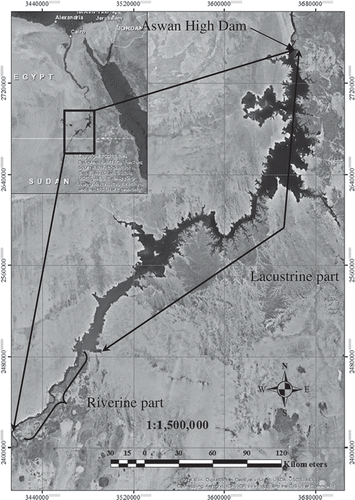
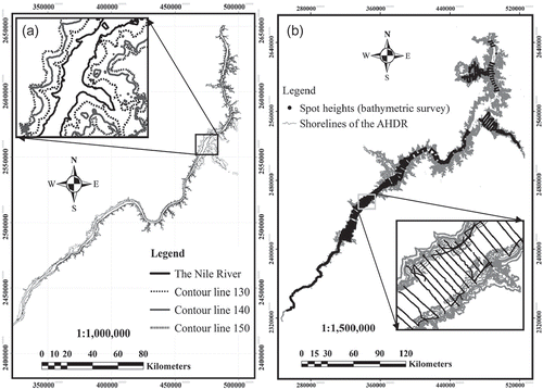
The AHDR is the third largest manmade reservoir in the world. It was formed as a result of the construction of the Aswan High Dam (AHD) across the Nile River. It is located in the hyper-arid zone in southern Egypt and northern Sudan. The reservoir extends between latitudes 21°02′–23°58′N and longitudes 30°37′–32°55′E (Elba et al. Citation2014). The slope of the reservoir shoreline is steeper on the rocky or stony, mountainous, eastern shore than on the flatter, wider, sandy, western one (El Shahat Citation2000). The reservoir is subdivided into two parts; a riverine part and a lacustrine part, as shown in . The maximum capacity of the AHDR was estimated before 1964 by the Ministry of Water Resources and Irrigation (MWRI) of Egypt as 162 km3 at the maximum water level of 182 m a.s.l. (Abu Zeid and El-Shibini Citation1997). The reservoir has an area of 6540 km2 (Elsawwaf et al. Citation2010), a length of 500 km (350 km of which lie in Egypt and 150 km in Sudan) (Omar and El-Bakry Citation1981) and an average width of 12 km. The total capacity of the lake comprises: (a) dead storage capacity of 31.6 km3 up to 147 m a.s.l. designed for the sediment deposits; (b) live storage capacity amounting to 90.4 km3 between 147 and 175 m a.s.l. to guarantee the annual water requirements, and (c) flood control capacity of 40 km3 between 175 and 182 m a.s.l. (Ibrahim et al. Citation2011).
Figure 1. Location map of the AHDR (ESRI Citation2014).
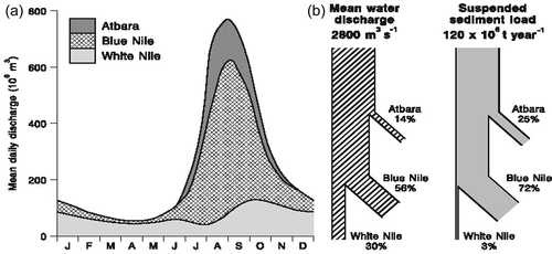
The average annual flow of the Nile River into the AHDR for the period 1965–2010 was about 73 km3 (based on data from MWRI). The flow is measured at Dongola station, 780 km upstream of the AHD. 70% of the mean annual flow comes from the Ethiopian Highlands through the Blue Nile and Atbara Rivers and 30% from the White Nile River. About 90% of the Nile River water during the flood period (August–November) comes from the Blue Nile and Atbara Rivers, while following this period most of the water comes from the White Nile River and its tributaries in the riparian countries (Mobasher Citation2010).
The annual sediment load deposited by the Nile River into the AHDR ranges from 50 to 228 million tons (Abul-Atta, Citation1978). As a result of the erodible upland terrains, high sediment supply and high runoff, approximately 97% of the annual suspended-sediment load originates from the Ethiopian Highlands during the flood period through the Blue Nile and Atbara Rivers (Woodward Citation2008), as depicted in .
Figure 2. (a) Typical annual flow regime of the Nile River at Aswan and the contributions from the three major tributary basins. (b) The discharge and suspended sediment budget of the Nile (after Woodward Citation2008, with permission from Wiley).
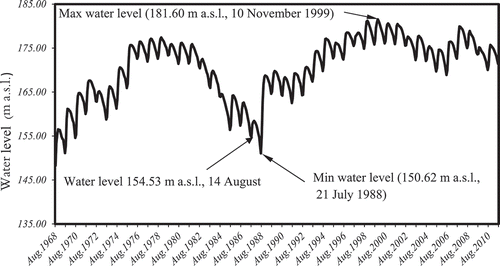
The water level of the reservoir started to increase on construction of the AHD in 1964. In 1975, the reservoir level reached the full storage level (175 m a.s.l.) and remained almost stable up to 1982. From 1983 to 1989 the storage level decreased, to 150.62 m a.s.l. in 1988, because of drought seasons. From 1998 to 2001 the reservoir was exposed to successive high floods and the water level approached the maximum storage level in November 1999 (181.60 m a.s.l.). From 2002 up to 2012, the level fluctuated between 168 and 178 m a.s.l., as shown in .
Figure 3. Water level upstream of AHD from 1968 to 2010 based on data from the MWRI.
3 Materials and techniques
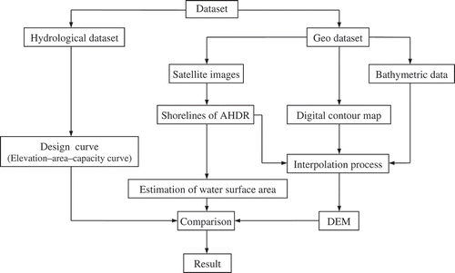
Landsat imagery with a spatial resolution of 30 m, the digital contour map of the AHDR area before the dam construction, and bathymetric data were employed to generate the DEM, as depicted in .
Figure 4. Flowchart of the methodology.
3.1 Satellite images
The main reason for using Landsat imagery in this study is its ability to yield instantaneous images of the shorelines of the AHDR as the water levels vary over time, and this is considerably difficult to achieve by ground survey. The reservoir is covered by the US satellites Landsat 4, 5, 7 and 8 through three sets of images identified by path/row numbers 174/44, 175/44 and 175/45. The minimum and maximum water levels represented on satellite images for the period 1984–2013 were 154.53 and 181.60 m a.s.l. On May 2003, Landsat 7 suffered a failure leading to loss of 22% of any given scene (http://landsat.usgs.gov/ productsslcoffbackground.php). Also, the reservoir is not covered by satellite images for the period 1992–1997. The Landsat data are listed by date in ascending order in .
Table 1. List of imagery with acquisition dates and the corresponding water levels at AHDR.
Band 4 of Landsat 4, 5 and 7, as well as band 5 of Landsat 8, were analysed to delineate the boundaries of the AHDR. Bands 4 and 5 (the near infrared bands with wavelengths of 0.77–0.90 µm and 0.85–0.88 µm, respectively) emphasize biomass content and shorelines as reported on the Landsat website (http://landsat.usgs.gov/best_spectral_bands_to_use.php.). ENVI 4.7 was used to mosaic (overlay) the satellite scenes that have overlapping areas to create one scene covering the whole reservoir area at an individual water level. Then the reservoir area was delineated by ISODATA unsupervised classification. The output of the reservoir delineation in ENVI 4.7 software was imported into ArcGIS and transformed to a shapefile. This shapefile was used to create the main polyline representing the shoreline of the reservoir at a particular water level. This process was conducted for the imagery sets representing the reservoir at different water levels as shown in . Every polyline was utilized as a contour line in the interpolation process to create the DEM.
Figure 5. (a) Digital contour map of the AHDR area before the dam construction based on data from MWRI. (b) Bathymetric survey data and boundaries of the AHDR extracted from satellite images for the period 1984–2013.
3.2 Digital contour map
The digital contour map of levels 120–150 m a.s.l. was developed from 1:100 000 topographic maps produced in 1960 (before the AHD construction) shown in . The digital map is utilized because the reservoir below a water level of 154 m a.s.l. is not represented by the satellite images.
3.3 Bathymetric survey data
The reservoir is surveyed almost every year by the MWRI. The bathymetric survey process is conducted by using Differential Global Positioning System (DGPS) and a digital echo-sounder. Most parts of the reservoir were surveyed in the years 2011–2012, except for some portions in the northern part of the reservoir as shown in . These parts are not exposed to sedimentation, and their morphology did not change. The bathymetric survey data were classified into categories according to the bed elevation of the reservoir to fill the gaps (non-surveyed areas) between the surveyed areas. Furthermore, because of the sedimentation in the southern part of the AHDR, the bathymetric data were used to adjust the contour lines of the digital map.
3.4 Interpolation process
All contour lines and spot heights were combined to create a DEM by using the Topo to Raster interpolation method in ArcGIS software. The Topo to Raster tool is an interpolation method particularly designed to generate hydrologically correct DEMs (ESRI Citation2014).
4 Results and discussion
The result of the interpolation process is a DEM of the AHDR represented as a raster. The DEM covers the area of the reservoir with a 25 m × 25 m grid spatial resolution. The new elevation–area–capacity curve based on the DEM was drawn to discover the changes that occurred in the reservoir.
4.1 Storage capacity
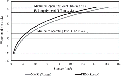
As shown in , the water volume of the AHDR estimated by the DEM at an elevation of 182 m a.s.l. is about 142.0 km3. The dead storage capacity is estimated at 25 km3 while the live storage capacity located between the levels 147 and 175 m a.s.l. is estimated as 78.0 km3. The flood control capacity is 39 km3 between levels 175 and 182 m a.s.l.
Figure 6. Comparison of the two storage curves: design curve and DEM curve.
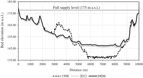
The main cause for the loss of about 12% of the storage capacity is sediment deposition. This loss of storage capacity occurred mainly in the live and the dead storage zones and slightly in the flood control zone. Widening of the reservoir at the entrance of the lacustrine part is accompanied by a further reduction of flow velocity leading to the accumulation of sediment deposits in this region. The sediment deposition surpassed the dead storage zone in the area located between 337.5 and 487 km upstream of the AHD, as clearly visible in –. Over the period 1996–2003, the water level was constantly above the elevation 175 m a.s.l., leading to sedimentation in the flood control zone. shows the sediment deposits accumulated on the both banks of the stream of the riverine part.
Figure 7. Changes in the bed elevation of the AHDR based on bathymetric survey data for 1964, 2008 and 2012 from data provided by MWRI.
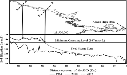
Figure 8. Upstream face of cross-section (A–A) at 431 km upstream of the AHD based on DEM and bathymetric survey data of 1998 and 2012 based on data provided by MWRI.
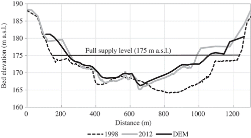
Figure 9. Upstream face of cross-section (B–B) at 337.5 km upstream of the AHD based on DEM and bathymetric survey data of 1998 and 2012 based on data provided by MWRI.
It should be noted that the design elevation–area–capacity curve of the reservoir adopted by MWRI was estimated by topographic maps at 1:25 000 scale. The main contour interval was 10 m, with supplementary contour intervals of 5 m between 160 and 190 m a.s.l. (Water Resources Research Institute Citation2007). These different methods of estimation lead to different results ().
Table 2. Storage capacity for different operating zones of AHDR estimated from MWRI curve and DEM.
4.2 Surface area
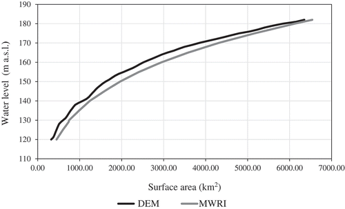
A comparison of the surface area curve created from the DEM, and the design curve of the AHDR is plotted in . This shows that the design curve is larger than the new curve, and the differences between them increase as the water level rises, in particular between water levels of 140 and 168 m a.s.l. The average reduction of the surface area between water levels 140 and 168 m a.s.l. is about 15%. Above the water level of 168 m a.s.l. the differences between the two curves decrease with an increase in the water level. The surface area of the AHDR estimated by the DEM at the water level of 182 m a.s.l. is 6350 km2, as shown in . This value is different from the value estimated by MWRI, which is about 6540 km2 and was estimated via 1:25 000 topographic maps.
Figure 10. Comparison of the two surface area curves: design curve and DEM curve.
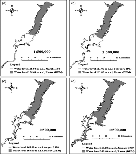
Further, the surface area of the AHDR for the period 1987–1990, at water levels 156.60, 161.0, 165.0 and 168.60 m a.s.l., was compared with its counterpart produced by the DEM. As shown in , the area of the AHDR decreased remarkably because of sediments. The decrease in the area of the AHDR is estimated by ArcGIS software to be 7% over the last 25 years. shows the reduction in the surface area estimated using the satellite images and the DEM.
Table 3. Surface area of the reservoir estimated from MWRI curve, satellite images and DEM.
Figure 11. Shape of the reservoir produced from DEM and satellite images.
Also, displays the path of the river inside the reservoir. This path gives insight into how the lacustrine part gradually changes to the riverine part and how the situation in this area is expected to progress in future years.
The morphology of the southern part of the AHDR has changed. Via satellite images, it was possible to observe this change over relatively small time intervals. The riverine part became narrower because of sediment deposition, as shown in . The morphology at the entrance of the lacustrine part under the 175 m a.s.l. level gradually converted into the riverine part as depicted in .
Figure 12. Changes at (a) the entrance of the lacustrine part of the AHDR below 175 m a.s.l. and (b) the entrance of the southern part of the AHDR above 175 m a.s.l., for the period 1998–2013.
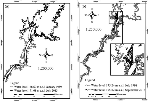
Two plots of the southern part of the AHDR for 1998 and 2013, at water levels 175.24 and 175.82 m a.s.l., respectively, are superposed and presented in . The two plots apparently match, but only the plot for 2013 shows that the sediment surpassed the 175 m a.s.l. level and is rising at the entrance of the lacustrine part. In the long run, a new delta could be formed through sediment deposition in this region.
5 Conclusions
The storage capacity of the AHDR estimated by the DEM decreased by 12% over the period 1964–2013. This reduction was mainly in the live storage capacity, the dead storage capacity, and slightly in the flood control zone. The live storage capacity, which guarantees annual water requirements, is estimated to be 78 km3. The results show a new elevation–capacity curve for the AHDR. This new curve gives a different estimate of the water volume that flows into the reservoir and the estimated water losses using the water balance method. The new storage curve guarantees the water demands for irrigation, hydropower and water supply. The live storage capacity still meets the annual downstream requirements for water (Egypt’s annual agreed quota from the Nile River is 55.5 km3). The increase of bed elevation of the southern part of the AHDR because of sedimentation hinders navigation and hydrographic survey after flood recession.
The surface area of the AHDR decreased, particularly at the low water levels, because of sedimentation. The average reduction in the surface area between water levels 140 and 168 m a.s.l. was about 15% over the period 1964–2013, which is equivalent to almost 10 km3. The morphology of the reservoir has changed because of sedimentation. The riverine part became narrower than before, and the entrance of the lacustrine part began to transform gradually into part of the river. Also, the sediment has surpassed the elevation of 175 m a.s.l. and is rising at the entrance of the lacustrine part.
Acknowledgements
The authors express their sincere thanks to the High Aswan Dam Authority (HADA) and the Ministry of Water Resources and Irrigation (MWRI) of Egypt for providing the bathymetric survey data and water levels on different dates and other relevant information for the study.
Disclosure statement
No potential conflict of interest was reported by the authors.
Related Research Data
References
- Abileah, R., Vignudelli, S., and Scozzari, A., 2011. A completely remote sensing approach to monitoring reservoirs water volume. International Water Technology Journal, 1 (1), 59–72.
- Abu El-Ata, A., 1978. Egypt and the Nile after the High Aswan Dam. Egypt: Ministry of Irrigation and Land Reclamation.
- Abu Zeid, M.A. and El-Shibini, F.Z., 1997. Egypt’s High Aswan Dam. International Journal of Water Resources Development, 13 (2), 209–218. doi:10.1080/07900629749836
- El Shahat, M.M., 2000. Lake Nasser overview. In: J.F. Craig, ed. Sustainable fish production in Lake Nasser: ecological basis and management policy. Penang: The International Center for Living Aquatic Resources Management, 3–6.
- Elba, E., Farghaly, D., and Urban, B., 2014. Modeling High Aswan Dam reservoir morphology using remote sensing to reduce evaporation. International Journal of Geosciences, 5, 156–169. doi:10.4236/ijg.2014.52017
- El-Manadely, M.S., et al., 2002. Characteristics of the delta formation resulting from sediment deposition in Lake Nasser, Egypt: approach to tracing Lake Delta formation. Lakes and Reservoirs: Research and Management, 7 (2), 81–86. doi:10.1046/j.1440-169X.2002.00174.x
- Elsawwaf, M., et al., 2010. Evaporation estimates from Nasser Lake, Egypt, based on three floating station data and Bowen ratio energy budget. Theoretical and Applied Climatology, 100 (3–4), 439–465. doi:10.1007/s00704-009-0168-z
- ESRI, 2014. ArcMap 10.2.1 ESRI, Redlands, CA.
- Gao, H., Birkett, C., and Lettenmaier, D.P., 2012. Global monitoring of large reservoir storage from satellite remote sensing. Water Resources Research, 48 (9). doi:10.1029/2012WR012063
- Goel, M.K., Jain, S.K., and Agarwal, P.K., 2002. Assessment of sediment deposition rate in Bargi Reservoir using digital image processing. Hydrological Sciences Journal, 47 (sup1), S81–S92. doi:10.1080/02626660209493024
- Ibrahim, A.S., El-Belasy, A., and Abdel-Haleem, F.S., 2011. Prediction of breach formation through the Aswan High Dam and subsequent flooding downstream. Nile Basin Water Science & Engineering Journal, 4 (1), 99–111.
- Jain, S.K., Singh, P., and Seth, S.M., 2002. Assessment of sedimentation in Bhakra Reservoir in the western Himalayan region using remotely sensed data. Hydrological Sciences Journal, 47 (2), 203–212. doi:10.1080/02626660209492924
- Jorgensen, S.E., et al., 2005. Lake and reservoir management. Vol. 54. Amsterdam: Elsevier.
- Mobasher, A.M., 2010. Adaptive reservoir operation strategies under changing boundary conditions – the case of Aswan High Dam Reservoir. Thesis (PhD). Darmstadt University of Applied Sciences.
- Nilsson, C., et al., 2005. Fragmentation and flow regulation of the world’s large river systems. Science, 308 (5720), 405–408. doi:10.1126/science.1107887
- Omar, M.H. and El-Bakry, M.M., 1981. Estimation of evaporation from the lake of the Aswan High Dam (Lake Nasser) based on measurements over the lake. Agricultural Meteorology, 23, 293–308. doi:10.1016/0002-1571(81)90115-1
- Palmieri, A., Shah, F., and Dinar, A., 2001. Economics of reservoir sedimentation and sustainable management of dams. Journal of Environmental Management, 61 (2), 149–163. doi:10.1006/jema.2000.0392
- Peng, D., et al., 2006. Reservoir storage curve estimation based on remote sensing data. Journal of Hydrologic Engineering, 11 (2), 165–172. doi:10.1061/(ASCE)1084-0699(2006)11:2(165)
- Rango, A., 1994. Application of remote sensing methods to hydrology and water resources. Hydrological Sciences Journal, 39 (4), 309–320. doi:10.1080/02626669409492752
- Schleiss, A.J., et al., 2014. Reservoir sedimentation. Leiden: Taylor & Francis Group.
- Smith, S.E., et al., 1983. Assessment and monitoring of sedimentation in the Aswan High Dam Reservoir using Landsat imagery. International Association of Hydrological Sciences, 499–508. IAHS Publ. no. 145.
- Takeuchi, K., 1998. Sustainable reservoir development and management. Wallingford: International Association of Hydrological Sciences.
- WCD, 2000. Dams and development: a new framework for decision-making. London: Earthscan, 356 pp.
- Woodward, J.C., 2008. The Nile: evolution, quaternary river environments and material fluxes. In: A. Gupta, et al., ed. Large rivers: geomorphology and management. West Sussex: John Wiley & Sons, 261–292.
- WRRI, 2007. Using remote sensing and numerical modeling techniques to evaluate Lake Nasser storage capacity for better management. Cairo: The Ministry of Water Resources and Irrigation.