
 ?Mathematical formulae have been encoded as MathML and are displayed in this HTML version using MathJax in order to improve their display. Uncheck the box to turn MathJax off. This feature requires Javascript. Click on a formula to zoom.
ABSTRACT
This study presents a high-resolution and multi-temporal drought climatology for Mauritius based on calculated standardized precipitation index (SPI) using mean monthly rainfall for the period 1953–2007. A monthly mean SPI varying from +3.4 to −2.7 indicates the occurrence of extremely wet and dry conditions, and collocated SPI indicates more frequent mild drought conditions. Spatial maps of rainfall trends and SPI show mostly neutral to severely dry conditions, but sparse regions of extremely wet and dry conditions are also observed. An increase in the frequency of dry years after the 1990s is noted, while most of the extreme wet conditions are found to have occurred between 1972 and 1988. More frequent short-duration wet events are observed on the 3- and 6-month time scales compared to dry events. On the 12- and 24-month time scales the frequency of both dry and wet periods is almost the same, with the dry events lasting longer.
Editor A. Castellarin Associate editor I. Overton
1 Introduction
Drought is a normal and periodic feature of climate, and is a relative rather than an absolute feature. The definition of drought varies from region to region, though it is broadly considered as a decrease in water availability during a particular period in a particular region. There are two main definitions of drought: conceptual and operational (Monacelli Citation2005). The conceptual definition, usually formulated in general terms, is meant to help people understand and feel the concept of drought; for example, an extended deficient precipitation causing significant damage to crops could be termed a period of drought. The operational definition of drought enables its quantification in terms of detection, duration and severity. It is basically based on a comparison of the actual situation with the long-term average for at least a 30-year or 50-year period of record, according to recommendations of the World Meteorological Organization and Guttman (Citation1999), respectively.
Given the different impacts under different degrees of water shortage, droughts have been categorized as meteorological, agricultural, hydrological or socio-economic (Monacelli Citation2005). Due to the economic and social impact, various indicators of drought have been derived in order to identify the onset and the eventual monitoring of a drought event. Drought indices are more useful in decision making than raw rainfall data. The most common indices include percent of normal (Monacelli Citation2005), deciles (Monacelli Citation2005), Palmer drought severity index (PDSI, Palmer Citation1965), surface water supply index (Shafer and Dezman Citation1982) and the standardized precipitation index (SPI; Mckee et al. Citation1993).
The SPI, relying only on precipitation data, has been used extensively for analysis of the rainfall regime over different parts of the world at different time scales varying from one month to several years (Hayes et al. Citation2000, Bordi et al. Citation2001a, Citation2001b, Hughes and Saunders Citation2002, Giddings et al. Citation2005, Pashiardis and Michaelides Citation2008, Du et al. Citation2012). Du et al. (Citation2012) used the SPI as an index to characterize both the spatiotemporal variation of dry/wet conditions in the Hunan Province of China, and, by further correlation with river discharge, its potential use in drought/flood monitoring was demonstrated. Formulated by Tom Mckee, Nolan Doesken and John Kleist of the Colorado Climate Center, USA, in 1993 (Mckee et al. Citation1993), the SPI is an index based on the probability of precipitation for any time scale, the most common being 1, 3, 6, 12 and 24 months. The SPI enables the categorization of an observed rainfall event as a standard departure with respect to a rainfall probability distribution function. Hence, precipitation at a station, for any duration, can be compared with the long-term precipitation record of the same duration. Further, SPI enables precipitation comparisons to be made at different locations with markedly different climates. As such, the SPI enables the depiction of the occurrence of dry or wet conditions for any rainfall station with historic data at a given time scale (temporal resolution) of interest.
Another commonly used index, the PDSI (Palmer Citation1965), requires information on soil moisture content. In fact, Hughes and Saunders (Citation2002) compared the SPI to the more complex PDSI and concluded that they behave similarly on time scales of 9 and 12 months. In some regions, the PDSI has been adapted and modified to cater for the climatic and land cover properties as well as the major parameters, which act as drivers of the drought. Such modified PDSI alongside the original PDSI have been used in several regions for analysis (Keyantash and Dracup Citation2002, Ntale and Gan Citation2003, Sousa et al. Citation2011).
The success of the SPI as a powerful and simple index has been exploited in many areas with different climate regimes around the globe and has gained worldwide application (Edwards and Mckee Citation1997, Guttman Citation1999, Wilhite et al. Citation2000, Bonaccorso et al. Citation2003, Rouault and Richard Citation2005, Manatsa and Mukwada Citation2012, Thomas et al. Citation2015). However, very few studies have been done for small tropical island states. Among the few studies that were available in the review process are those of Deo (Citation2011), who worked on meteorological drought in the tropical Pacific Islands, and White et al. (Citation1999), who worked on droughts in the small coral islands of Kiribati in the Central Pacific. Other studies have focused on larger subtropical islands, such as Crete (Vrochidou and Tsanis Citation2012) and Cyprus (Pashiardis and Michaelides Citation2008). Further, in some studies, SPI has been modelled using geostatistical techniques to generate spatial maps. Such studies have been carried out to analyse drought indices in Iran (Ali et al. Citation2011) and India (Sharma et al. Citation1998).
Currently, the precipitation zones for Mauritius are based mainly on precipitation amount and to some extent on climatic regions. Although this method of mapping does provide the necessary information for calculating total amount of rainfall and for locating catchment areas, it does not contribute much to studying how far the different regions of the island or catchment areas are becoming drier or wetter. At present, none of the above indices have been worked out extensively for the island, and no rigorous dry and wet zones have been demarcated. Paradoxically, with the impact of the warming trend on climate, such an assessment has not only become essential but rather mandatory. The assessment reports of the Intergovernmental Panel on Climate Change (IPCC) highlight how the trend in rainfall in the Indian Ocean varies from region to region, with an increasing tendency in the north but a decrease in the south. In fact, in the vicinity of Mauritius, climate models indicate decreases, particularly in the months of June, July and August (IPCC Citation2007). Thus, verification of such climate forecasts, through analysis of trends at the local scale, has become very important for planning purposes.
The objectives of this study are threefold. The first is to calculate the SPI for Mauritius at different time scales using collocated mean monthly rainfall and to generate accurate spatial maps of SPI and also of its trend at various time scales, namely 3, 6, 12 and 24 monthly, using geostatistical techniques. Secondly, we aim to calculate the collocated trends in the rainfall and SPI, and map these using geostatistical techniques. The third objective is to calculate and map the spatiotemporal variation in dry and wet conditions in Mauritius in terms of number of events and their mean duration, at the various time scales.
2 Study area and climate
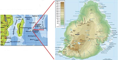
Mauritius forms part of the commonly known Mascarene Islands and lies between latitudes 19°58.8′–20°31.7′S and longitudes 57°18.0′–57°46.5′E, near the edge of the southern tropical belt. It has an area of about 1860 km2 and is approximately 61 km long from north to south and 47 km across from east to west. The island consists mainly of flat lowland to the north, with rather hilly and mountainous lands to the southwest. The highest point is 828 m above sea level ().
Figure 1. Location of Mauritius in the Southwest Indian Ocean.
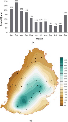
Mauritius has a moderate tropical maritime climate and is swept constantly by the southeast prevailing winds. Two seasons prevail over the island: a warm and rainy summer season, which extends from November to April, and a relatively drier winter from May to October though May and October are usually considered as transition months. The mean annual precipitation over the island is 2100 mm, varying from 1500 mm on the east coast to 4000 mm on the central plateau and 900 mm on the west coast. Throughout the year, January–March is the wet season, while September–November is the dry season, during which deficient rainfall days are more prone to occur (). Spatial rainfall distribution shows that the central plateau region harvests most of the rainfall. The west, which is the leeward side of the island, and also the northern part of the island, which is mainly flat, receive the least amounts of rainfall ().
Figure 2. (a) Monthly long-term mean rainfall (1981–2010) and (b) spatial distribution of long-term mean rainfall (1981–2010).
3 Data and methods
3.1 Data analysis
The island of Mauritius has a high density of rainfall stations with rainfall data dating back to 1850 for some stations, but there has been a continuous decrease in the number of stations in time. This study aims to generate spatial maps for the period 1953–2007, building a reliable database by initially considering precipitation data from about 220 rainfall stations provided by the Mauritius Meteorological Services. We discarded all those stations that have undergone relocation or have missing data ranging from a few days to over 3 months, or have unexplained outliers, as follows:
All stations having at least a fortnight (14 days) of continuous missing data were discarded. For the remaining stations, the missing data were interpolated from neighbouring stations using the linear interpolation technique. When appropriate neighbouring stations were not available for interpolation, the stations with the missing values were also discarded.
The selected stations were further scrutinized for outliers in their monthly mean values using box plot analysis. All stations reporting extreme values that could not be explained based on the daily prevailing weather during that month were either discarded, or the days reporting extreme rainfall were replaced via interpolation from neighbouring stations, where available.
The filtering and cross-validation process reduced the number of reliable stations to 115. The corresponding collocated monthly SPI values, based on the 3-, 6-, 12- or 24-month time scales, were calculated for the period 1953–2007 by implementing an SPI algorithm in the MATLAB computing environment. Also, the number and mean duration of particular classes of dry/wet events and the trends in the rainfall and different SPIs over these 55 years were mapped to identify dry or wet regions at the different time scales. Spatial maps were generated in order to assess the extent of dry and wet regimes experienced by the different regions of the island over time. The ordinary kriging interpolation method involves first fitting an appropriate variogram model to the experimental semi-variogram for rainfall and the SPI spatial dataset, and then interpolation using a regular grid system.
3.2 Drought classification
The SPI is usually derived from the long-term precipitation records fitted to a probability distribution, which is transformed into a normal distribution afterwards such that the mean of the SPI is zero. The wet and dry conditions can be categorized depending on the SPI values. SPI values greater than the median value are positive (wet conditions), while those below the median are negative (dry conditions). For instance, Mckee et al. (Citation1993) defined a drought to occur anytime when the SPI value is consistently negative and reaches an intensity of ≤−1.0; once the SPI becomes positive, the drought event ends. Similarly, as the SPI becomes consistently positive, with an intensity of ≥1.0, the condition is classified as wet. Similar categories are used in this study, as shown in , but with the SPI values between ±1 further subdivided into a category of ±0.5 in order to indicate regions where normal conditions (−0.49 ≤ SPI ≤ 0.49) prevail on the different time scales.
Table 1. Thresholds for drought characterization over Mauritius.
3.3 SPI calculation
The SPI developed by Mckee et al. (Citation1993) has been elaborated in several other works, e.g. Guttman (Citation1999), and the derivation that follows is based upon these previous works. Mathematically, the SPI is based on the cumulative probability of a given rainfall event occurring at a station. The rainfall behaviour is right-skewed. Thom (Citation1958) found the gamma distribution to fit such climatological time series well. Thus, the gamma distribution is used to fit climatological precipitation time series defined by its probability density function:
where v > 0 and Ψ > 0 are the shape and scale parameters, respectively; x > 0 is the precipitation amount; and Γ(v) is the gamma function, defined by:
The gamma probability density function is fitted to the frequency distribution of the precipitation totals of each station. The scale and shape parameters are estimated for that station, with the number of observations, n, for each time scale of interest and for each month of the year. These are estimated by using the maximum likelihood estimation, as follows (Thom Citation1958):
where and
.
The calculated parameters are then used to find the cumulative probability of an observed precipitation event at that station for the given month and time scale, denoted by:
Since the gamma function is defined for x > 0, to account for zero rainfall values, the cumulative probability is expressed as:
where q is the probability of zero rainfall. Thus, the process allows the rainfall distribution at the station to be effectively represented by a mathematical cumulative probability function. Using historic rainfall data, the probability of the rainfall being less than or equal to a certain amount can be evaluated. For instance, a particular rainfall event giving a low probability on the cumulative probability function is indicative of a likely drought event, and vice versa. Also, given that the probability function for precipitation for each station is distinct, due its specificity, it is very difficult to contrast rainfall events between different locations in terms of drought, as drought is really a “below-normal” rainfall event and what is “normal rainfall” in one area can be surplus rainfall in another. To overcome this problem, the cumulative probability gamma function, H(x), is transformed into a standard normal random variable Z ~ N(0,1) (Abramowitz and Stegun Citation1964, 1972), leading to the SPI value often referred as a “Z score”. The unit of the SPI can thus be considered to be “standard deviations”.
4 Results and discussion
4.1 Precipitation and SPI statistics
The box plot in shows the seasonality pattern of monthly total precipitation based on the data of 115 stations on the island of Mauritius, with the highest median, range and interquartile range values, as well as extreme wet conditions shown as outliers during the summer period. displays the 95% confidence intervals for the average of the total precipitation for each month. One-way analysis of variance (ANOVA) shows a significant difference in the mean precipitation at the 5% significance level for the different months, except for similar distributions for the pairs September–November, June–July and January–March.
Figure 3. (a) Box plot of monthly mean precipitation, (b) one-way analysis of variance (ANOVA) of monthly mean precipitation, (c) box plots of 3-monthly SPI (SPI-3) for 115 stations and (d) box plot of SPI-3 at the monthly time scale at a particular station.
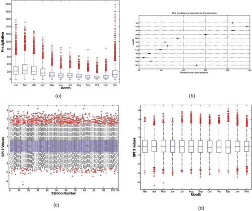
Although it is empirically rare to observe SPI values greater than +3.0, or less than −3.0 (Guttman Citation1999), calculated monthly values of SPI show that, at a certain point in time, extreme dry or wet conditions were experienced at some locations on the island. For instance, from the dataset, it is observed that SPI values in absolute values above 4 were recorded at some stations, although the incidence of such extreme values did not necessarily occur in the same year, month or at the same time scale/at the same station ( and ). Box plot analysis shows similar temporal and spatial variability in the SPI values at the other time scales, where all stations – at some point in time – experienced extremely wet or dry conditions. Some of the extreme wet conditions could be associated with tropical cyclones or the El Niño phenomenon, and the extreme dry values with La Niña. A time series of SPI and rainfall is shown in Section 3.3.
4.2 SPI variogram models
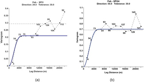
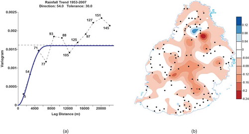
The cubic variogram model gives the best fit for the SPI at all time scales, as well as the lowest cross-validation root mean square error. Examples for the month of February at time scales of 3 and 24 months are shown in . The sill is found to be reached at a short range of about 6000–7000 m, indicating a marked spatial variability in the index, even at very short range. The variations observed are similar for all the months, except that the direction of maximum correlation varies from month to month owing to the different weather systems influencing the rainfall pattern.
Figure 4. Cubic variogram model fit for February SPI on (a) 3-month and (b) 24-month time scales.
4.3 Rainfall and SPI trend
It is noted with concern that, of the 115 stations, 88% and 86% show a general significant negative linear trend in precipitation and SPI, respectively, with time, at the 5% significance level. However, with low correlation coefficients, such trends are observed at the various time scales, thus revealing that there is a general decrease in precipitation on Mauritius, as well as an increase in the number of drier events. When considered at the micro-scale level, some regions do indicate opposite tendencies. To illustrate this, the trends in rainfall and SPI for two stations (Plaisance and Antoinette) at the 12-month time scale (SPI-12) are shown in . For Plaisance, a main synoptic station located to the southeast, a slight decrease in rainfall of about 0.0018 mm/year is observed, while for Antoinette, a rainfall station located in the central north, a slight increasing tendency in rainfall by 0.0009 mm/year is observed. Even if the trends are weak, both a large inter-annual and intra-annual variability in the rainfall is discernible (), and this variability renders water management quite challenging.
Figure 5. (a) Rainfall and (b) SPI12 time series for the period 1953–2007 at Plaisance (red line) and Antoinette (blue line).
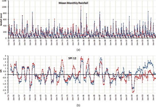
The rainfall time series alone does not fully highlight the dry and wet periods that the island has experienced. For instance, the island underwent some marked dry and wet periods in the period 1953–2007. One very well-known dry period is the year 1999/2000, which was associated with a strong La Niña event, and some of the wettest years include 1972/73, 1982/83 and 1987/88, which were associated with El Niño events of at least moderate intensities. These extreme events become more discernible in the time series of the SPI-12, as shown in . In fact, the SPI-12 reveals an equally extreme dry period in the year 1961/62 and an extreme wet period in the year 1980/81, which occurred in a neutral and a weak El Nińo Southern Oscillation (ENSO) year, respectively. For all these extreme events, at several stations over the island, the SPI values plummeted below −3.0 for the drought years and went well above +3 for the wet years, as shown in and . These findings for Mauritius are in line with those of White et al. (Citation1999), who associated the incidence of extreme wet and dry spells for small island states across the Indian and Pacific oceans with ENSO. However, as demonstrated for Mauritius, such extreme conditions may also occur in neutral years.
The SPI-12 time series show an equal and almost alternate occurrence of dry and wet conditions in the period 1953–1972, with predominantly wet events, reaching extreme intensities, from 1973 to 1988, and mostly dry conditions beyond the 1990s. Such observations were also made by Deo (Citation2011) in the island of Fiji, where droughts were observed in the periods 1949–1968 and 1989–2008. However, Deo (Citation2011) observed most of the extreme droughts in Fiji in the earlier period (1949–1968), while in Mauritius such droughts occurred after the 1990s. However, in general, similar to Fiji (Deo Citation2011), a decreasing tendency in the SPI at the different time scales is observed for Mauritius. In fact, for Mauritius, dry months have become more frequent since the 1990s, as shown by the time series of Plaisance (). These results give a clear indication of the vulnerability of Mauritius in a warming climate, where wet conditions, even mild ones, have a tendency to become more scarce. However, such findings are not limited to tropical islands; such results have been reported by Sousa et al. (Citation2011) for most countries in the western and central Mediterranean regions during the 20th century.
In spite of Mauritius being a very small island, it is observed that the tendencies for wet or dry conditions at the different locations are not the same for any particular event. This is observed, in particular, for years prior to 2000. For example, for the drought of 1999/2000, Plaisance was drier than Antoinette, while in 1961/62 the opposite conditions were observed. Similar opposite tendencies were observed at these two stations in the wet years 1982/83 and 1987/88. However, beyond the year 2000, Antoinette is observed to be constantly wetter than Plaisance; this is an indication that wet regions are likely to become wetter, while drought prone regions become drier. Such an observation has been made on a large scale in the report of the IPCC (Citation2007), but similar behaviour is even observed at the micro-scale. In fact, similar to rainfall, an increasing trend in SPI is observed at Antoinette and a decreasing trend at Plaisance.
The spatial map of rainfall trend (), which is interpolated from a cubic variogram model ()), gives a better insight into the drying and wetting tendencies at different locations over Mauritius, which can provide useful information for water resource managers. As stipulated earlier, there are regions with increasing rainfall tendencies of different magnitudes. A large part of the island also shows neutral conditions. However, the drying tendencies over most of the central plateau regions are quite alarming, given that these regions are the cradle of freshwater storage for the island. Another striking pattern is the inverse trends that appear as dipoles in some locations; these are particularly marked to the north, an indication of strong spatial variability that exists at such a small scale. Such dipoles have been reported on a larger scale by Sousa et al. (Citation2011) in the Mediterranean region.
Figure 6. (a) Cubic variogram model fit and (b) spatial distribution of rainfall trend.
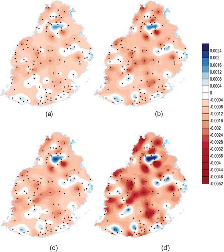
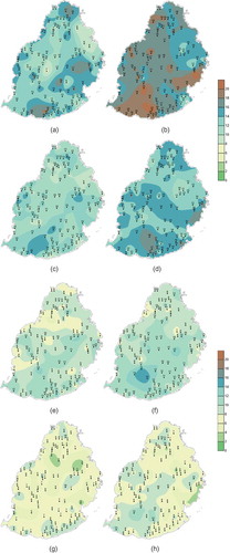
Even if the rainfall trend map indicates the tendencies of the different regions over the island over 55 years, it does not describe the conditions at different time scales. The spatial maps of the SPI, interpolated from cubic variogram models, provide such an insight at the different time scales (). The presence of several dipoles and tripoles of inverse trends in SPI distribution confirm the extent to which rainfall can be variable in both space and time, even at such a small scale. On the whole, most parts of Mauritius show a decreasing trend in SPI, with very localized positive trends scattered over the island, particularly to the north, east and south. The patterns are almost similar at all time scales, and only the magnitude changes. Drought-prone regions become drier, while those showing wet conditions become wetter as the scale increases from 3 months to 24 months. Similar to the rainfall, the SPI also shows decreasing trends over most of the central plateau regions.
Figure 7. Spatial distribution of SPI trend at (a) 3-month, (b) 6-month, (c) 12-month and (d) 24-month time scales.
4.4 Distribution of dry and wet conditions
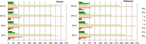
shows the number of months, for two main synoptic stations over the island, namely Vacoas, located on the leeward side of central plateau, and Plaisance, a coastal station located to the southeast, in which different categories of dry/wet conditions prevailed.
More frequent mildly dry and mildly wet conditions are observed for all time scales, as shown by the number of occurrences of over 200 in the bars for I4 and I5 (see for definitions), followed by moderately dry and moderately wet conditions (I3 and I6). However, the incidence of moderately dry conditions is higher than that of moderately wet conditions for both stations and at all time scales, as shown by higher values of I3 compared to I6. This is not the case for severe and extremely wet conditions (I7 and I8), which are more frequent than their dry counterparts (I2 and I1).
4.5 Number and duration of dry and wet events
The trends in the SPI shown in enable a rough guess to be made of the number and duration of different severities of dry and wet events that occurred in the period 1953–2007. Spatial maps of the number and duration of these events at each location were generated to give a better representation of the occurrences of these different conditions over the various parts of the island. A dry event is said to have occurred if at least three consecutive months experienced severe and/or extremely dry conditions. Similarly, a wet event is said to have occurred if at least three consecutive months experienced severe and/or extremely wet conditions.
Figure 8. Number of months for which dry or wet conditions prevailed at Vacoas (left) and Plaisance (right) stations. See for details of I1–I8.
The numbers of dry and wet events at different time scales are shown in . At the 3-month time scale, the number of stations reporting 15–20 wet events is higher than those reporting 15–20 dry events, as shown in and , respectively. An almost similar observation can be made for the 6-month time scale. This indicates that, at these two time scales, wet events slightly supersede the dry events. This may seem contradictory to the observations made based on the SPI trends, but the higher number of wet events at these two time scales is due mostly to the predominant occurrence of the latter prior to the 1990s. At the 12- and 24-month time scales, the number of stations reporting different numbers of dry and wet events tends to be the same. As the time scale increases, the number of both wet and dry events, as defined above, decreases and is limited to 10 events. This should be expected because, over a longer period, dry and wet spells may be compensating each other.
Figure 9. Spatial distribution of the number of dry events (left) and wet events (right) at (a,b) 3-month, (c,d) 6-month, (e,f) 12-month and (g,h) 24-month time scales.
The mean drought duration, in months, is calculated as the ratio of the total number of months that the above-defined dry events last to the total number of dry events (and the same for wet events). The spatial distribution of the duration of the dry and wet events is shown in .
Figure 10. Spatial distribution of duration of dry (left) and wet events (right) at: (a,b) 3-month, (c,d) 6-month, (e,f) 12month- and (g,h) 24-month time scales.
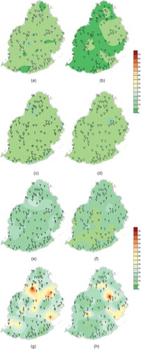
A very pertinent observation is the duration of wet events at the 3-month time scale. Even if the occurrence of wet events at this time scale is higher (), it is likely to last for less than 5 months at most stations, with a maximum of 10 months at some stations, mostly over the eastern half of the island (). The opposite is observed for the dry events, which are lower in number at this time scale, but likely to last for up to 15 months at some stations and 10 months at most stations (). This can be a very useful result for water resource managers for planning purposes at short time scales. At the 6-month time scale, an almost similar duration for both dry and wet spells is observed, with both lasting for up to 10 months at most stations ( and ). At the 12-month time scale, the duration of any dry event at a station tends to supersede a wet event at the same station, while at the 24-month time scale, the opposite is observed.
Overall, it is observed that, when the number of dry or wet events is high, their duration tends to be shorter.
5 Conclusions
Until now, rainfall over Mauritius has mostly been assessed based on the usual monthly, seasonal and annual distribution maps. This had also allowed us to calculate and map the anomalies with respect to different climatic periods, such as 1961–1990, 1971–2000 and 1981–2010. However, this study has revealed more valuable information within the context of drought occurrence, as well as that of surplus rainfall. It has shed light on another dimension of the rainfall pattern of the island of Mauritius, where areas prone to dry and wet conditions at different time scales have been demarcated. By virtue of its ability to assess dry and wet conditions over a wide spectrum of time scales, the SPI, calculated on the 12- and 24-month time scales, has enabled the identification of long-lasting and high-impact events, which are likely to seriously affect the socio-economic activities of the island. The pertinent observations from the study include the following:
Most of the island shows neutral to mild wet/dry conditions at all time scales, the latter being slightly more prevalent at time scales of 24 months. However, localized regions experiencing severe to extremely dry and wet conditions are also observed for all months of the year, particularly at time scales of 12 and 24 months.
Most of the island shows neutral to decreasing rainfall trends, with the exception of a few locations to the south, east and north. Most parts of the central plateau, which contains most of the freshwater reservoir of the island, show a decreasing rainfall trend. This calls for urgent strategies in water resources management and the need for preparedness plans, particularly in those areas exposed to extreme droughts.
The months of May, August, September and December are critical, since they are likely to face extremely dry conditions, even at the 3-month time scale. Such drought conditions can have an immediate negative impact on agriculture (Vrochidou and Tsanis Citation2012).
At time scales of 3 and 6 months, the number of wet events is higher than that of dry events, but events are shorter in duration. However, wet events were very common in the period 1973–1988. After the 1990s, Mauritius witnessed mostly dry spells and there are indications that this trend will persist.
Contrary to the traditional precipitation maps, the SPI maps stand as a better product to provide an intelligible basis for assessing the changing rainfall pattern over the island of Mauritius at different time scales, and also set the scene for future research.
Acknowledgements
The authors express their gratitude to the Mauritius Meteorological Services for providing the necessary data, without which such an exhaustive analysis could not be envisaged.
Disclosure statement
No potential conflict of interest was reported by the authors.
References
- Abramowitz, M. and Stegun, I.A., 1964, 1972. Handbook of mathematical functions. New York: Dover Publications.
- Ali, M.G., et al., 2011. Assessment of geostatistical methods for spatial analysis of SPI and EDI drought indices. World Applied Sciences Journal, 15 (4), 474–482.
- Bonaccorso, B., et al., 2003. Spatial variability of drought: an analysis of the SPI in Sicily. Water Resources Management, 17, 273–296. doi:10.1023/A:1024716530289
- Bordi, I., et al., 2001a. The analysis of standardized precipitation index in the Mediterranean area: large scale patterns. Annali Di Geofisica, 44, 965–978.
- Bordi, I., et al., 2001b. The analysis of standardised precipitation index in the Mediterranean area: regional patterns. Annali Di Geofisica, 44, 979–993.
- Deo, R.C., 2011. On meteorological droughts in the Tropical Pacific Islands: time-series analysis of observed rainfall using Fiji as a case study. Meteorological Applications, 18, 171–180. doi:10.1002/met.216
- Du, J., Xu, W., and Shi, P., 2012. Analysis of dry/wet conditions using the standardised precipitation index and its potential usefulness for drought/flood monitoring in Hunan province, China. Stochastic Environmental Research and Risk Assessment, 27 (2), 377–387. doi:10.1007/s00477-012-0589-6
- Edwards, D.C. and Mckee, T.B., 1997. Characteristics of 20th century drought in the United States at multiple time scales [online]. Fort Collins, CO: Department of Atmospheric Science, Colorado State University. Available from: http://ccc.atmos.colostate.edu/edwards.pdf
- Giddings, L., et al., 2005. Standardized precipitation index zones for Mexico. Atmosfera, 18, 33–56.
- Guttman, N., 1999. Accepting the standardised precipitation index: a calculation algorithm. Journal of the American Water Resources Association, 35, 311–322. doi:10.1111/j.1752-1688.1999.tb03592.x
- Hayes, M.J., Svoboda, M.D., and Wilhite, D.A., 2000. Monitoring drought using the standardized precipitation index. Drought Mitigation Center Faculty Publications, 70.
- Hughes, B.L. and Saunders, M.A., 2002. A drought climatology for Europe. International Journal of Climatology, 22, 1571–1592. doi:10.1002/(ISSN)1097-0088
- Intergovernmental Panel on Climate Change (IPCC), 2007. Climate change 2007: the physical science basis. In: S. Solomon, et al., eds. Contribution of Working Group I to the Fourth Assessment Report of the Intergovernmental Panel on Climate Change [online]. Cambridge, UK: Cambridge University Press.
- Keyantash, J. and Dracup, J., 2002. The quantification of drought: an evaluation of drought indices. Bulletin of the American Meteorological Society, 83, 1167–1180. doi:10.1175/1520-0477-83.8.1167
- Manatsa, D. and Mukwada, G., 2012. Rainfall mechanisms for the dominant rainfall mode over Zimbabwe relative to ENSO and/or IODZM. The Scientific World Journal, 2012, 1–15. doi:10.1100/2012/926310
- Mckee, T., Doesken, N., and Kleist, J., 1993. Drought monitoring with multiple timescales. In: Eighth conference on applied climatology, Anaheim, California.
- Monacelli, G., 2005. Drought assessment and forecasting. World Meteorological Organization: Weather, Climate and Water, Technical report.
- Ntale, H.K. and Gan, T.Y., 2003. Drought indices and their application to East Africa. International Journal of Climatology, 23, 1335–1357. doi:10.1002/(ISSN)1097-0088
- Palmer, W.C., 1965. Meteorological drought. US Weather Bureau Research Paper, 45, 64.
- Pashiardis, S. and Michaelides, S., 2008. Implementation of the standardised precipitation index (SPI) and the reconnaissance drought index (RDI) for regional drought assessment: a case study for Cyprus. European Water, 23/24, 57–65.
- Rouault, M. and Richard, Y., 2005. Intensity and spatial extent of droughts in southern Africa. Geophysical Research Letters, 32. doi:10.1029/2005GL022436
- Shafer, B.A. and Dezman, L.E., 1982. Development of a surface water supply index (SWSI) to assess the severity of drought conditions in snowpack runoff areas. In: Proceedings of the western snow conference. Fort Collins, CO: Colorado State University, 164–175.
- Sharma, A., et al., 1998. Drought monitoring using standardized precipitation index: a case study for the state of Karnataka, India. Geospatial World, 248, 51–58.
- Sousa, P.M., et al., 2011. Trends and extremes of drought indices throughout the 20th century in the Mediterranean. Natural Hazards and Earth System Sciences, 11, 33–51. doi:10.5194/nhess-11-33-2011
- Thom, H.C.S., 1958. A note on gamma distribution. Monthly Weather Review, 86, 117–122. doi:10.1175/1520-0493(1958)086<0117:ANOTGD>2.0.CO;2
- Thomas, T., Nayak, P.C., and Ghosh, N., 2015. Spatiotemporal analysis of drought characteristics in the Bundelkhand region of Central India using the standardised precipitation index. Journal of Hydrologic Engineering of ASCE, 20, 05015004. doi:10.1061/(ASCE)HE.1943-5584.0001189
- Vrochidou, A.E.K. and Tsanis, I.K., 2012. Assessing precipitation distribution impacts on droughts on the island of Crete. Natural Hazards and Earth System Sciences, 12, 1159–1171. doi:10.5194/nhess-12-1159-2012
- White, I., Falkland, T., and Scott, D., 1999. Droughts in small coral islands: case study, South Tarawa, Kiribati. In: International hydrological programme, technical documents in hydrology, 26, Paris: UNESCO.
- Wilhite, D., Sivakumar, M., and Wood, D., 2000. Early warning systems for drought preparedness and drought management. In: Proceedings of an expert group meeting, 5–7 September, Lisbon, Portugal. WMO TD No. 1037.