
ABSTRACT
This article aims to analyse the process of connecting the railway and the port of Setúbal within the development of sustainable urban policies. Since the nineteenth century, cities have faced challenges concerning the logistics of transportation. The urban specificities of port cities attracted the attention of experts in the mid-twentieth century, after some cities had relocated or restructured their port areas. Consequently, by the end of the twentieth century, intermodality became a fundamental tool to guarantee a sustainable urban plan. Currently, the sustainability paradigm has increased the concerns about port cities, due to their environmental, social, and economic qualities. This article aims to explore the historical relationship between the railway and the port of Setúbal. Focus is placed on the attempts to develop an intermodal system in Setúbal, while confronting it with its urban development. By discussing the restructuring process of the port of Setúbal since the arrival of the railway, this paper provides an overview of the interests and actors involved in the connection between these infrastructures. The historical analysis of the port-rail infrastructure reveals the urgency of this kind of understanding for current and future sustainable urban planning.
Introduction
As societies aim to become more sustainable, theoretical contributions on the relationship between railway and the port infrastructures are important for deepening our knowledge of intermodality and urban revitalization, or urban reintegration, of these areas. The concept of sustainability was defined in 1972 at the United Nations Conference on the Human Environment, also known as the Stockholm Conference.Footnote1 The report produced there expressed fundamental concerns about natural resources, demographic growth, human environment, and natural environment.
The rail-port infrastructure was only inserted in discussions about sustainability in 1987, when ‘Our Common Future’Footnote2 was published for the ‘World Commission on Environment and Development Future’. This report considered the areas occupied by these means of transport as areas of significant urban potential. It mentions several initiatives concerning the drafting of urban plans to improve the port area. The main reason for this concern was the creation of derelict urban spaces after the relocation of port infrastructures around the world during the 1960s, due to technological changes and the increase in port services.
To guarantee sustainable mobility, the term ‘intermodal’ (or multimodal) appeared for the first time in discussions about sustainable environments in the 2002 World Summit on Sustainable Development.Footnote3 As a result, the elaboration of projects to link the various means of transport to improve the urban environment increased in prominence on the political agenda. To reinforce the relevance of the railway in sustainable mobility researches, the European Union chose 2021 as the ‘European Year of Rail’.Footnote4 However, even though the means of transport is one of the keys to a sustainable city, little has been studied about the development of the connection between the railway and the port over the years.
The impact of railways on the urban fabric has been increasingly studied since the mid-twentieth century. However, as the geographer Horácio Capel (Citation2011) Footnote5 states, no plan has ever been designed in such a way as to explain in a detailed way the relationship between the railway and other urban elements to guarantee a functional railway implementation and its aggregation into the set of services of a metropolitan area.
Social, economic, and technological changes have defined the integration of the railway into urban principles developed in the nineteenth century and twentieth century. This is exemplified by the healthy city of Richardson (Citation1876), with its underground railway; the garden-city of Howard (Citation1898), with the railway running along the periphery; the linear city of Arturo Soria y Mata (Citation1892), with rails installed in the city’s centre; and the industrial city of Tony Garnier (Citation1917), with an underground railway surrounding the urban layout and an intermodal station. However, there is a lack of urban analysis on the relationship between large-scale infrastructures, for example the railway and the port. Even the Spanish engineer Ildefonso Cerdá (1815–1876)Footnote6, considered a pioneer in urban planning, did not develop a deeper analysis of port areas in his general theory or in the proposed plans for Barcelona.
At the beginning of the twentieth century, the Scottish biologist and philosopher Patrick Geddes (1854–1932)Footnote7 highlighted the German planning for Frankfurt New Docks, describing it as a ‘masterpiece’ of urban planning; a project that coordinated port and railway and offered solutions for developing commercial activities and ensuring a salubrious environment on the docks.
Nevertheless, in O’Flanagan’s (Citation2008)Footnote8 opinion, studies on port cities only considered the port’s maritime function, disregarding its influence on urban development. In addition, ports were studied with no reference to their cities. Therefore, even though the urban theories were in an evolving process since the mid-nineteenth century, it took some time for the port infrastructure to become a part of the urban planning agenda. In this context, land transportation networks, such as the railway, formed a single system, conditioned by the port activities. According to José Mª Ureña Francés and Julio Pozueta Echavarri (1986)Footnote9, port areas around the world only got the attention they deserved in urban plans in the mid-twentieth century.
In Portugal, some authors have analysed the history of railways by relating them to port services on a national scaleFootnote10, but many of these studies are supported by historical-economic analysis.Footnote11 Only a few more recent works focus on the urban impact of railway.Footnote12 Even then, these are mostly more generic studies, which do not explore regional or local scales.Footnote13 Consequently, there are few comparative studies.Footnote14 Usually, the studies which relate to the spatial organization of cities analyse the installation of railway stations and the impact of the technological change of the railway system.Footnote15
Setúbal, a Portuguese city located in the Metropolitan Area of Lisbon, is often mentioned in studies of the history of the railway in Portugal. The first railway station of Setúbal played an important role in transporting goods between Lisbon and the Alentejo region, in the Portuguese hinterland.Footnote16 Consequently, even with the increased importance of the port of Sines (located approximately 80 km from Setúbal) since 1986, the role that Setúbal’s the transport infrastructure has played in the history of Portugal cannot be underestimated.
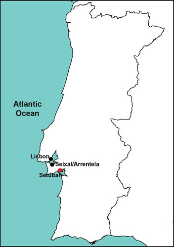
With docks spanning approximately 12 km, the port of Setúbal is connected to the Atlantic Ocean by the Sado River. Like the Tagus estuary, the Sado estuary is one of the connections between the Lisbon Metropolitan Arc and the sea.Footnote17 The importance of the railway in this connection is illustrated through the influence that the link between this infrastructure and the port of Setúbal had on the appearance of cork factories in Seixal and wool manufacturing in Arrentela, two towns from the Lisbon Metropolitan Arc located on the Tagus Estuary ().
Figure 1. Draft of Setúbal, Lisbon, Seixal and Arrentela location. Designed by the author.
In the early twentieth century, when the railway of Setúbal was extended to the port area, the port was classified as a second-class port. This classification, designated in the 1920s, was a part of plans to increase the participation of port activities in the country's economy. Thus, in terms of importance, the port of Setúbal, as a port of regional interest, only lost out to ports of national interest, such as the first-class ports of Lisbon and Douro-Leixões. Although the railway was part of this valorization of the Setúbal port area, there has been little discussion of how the connection of these means of transport occurred from an urban perspective.Footnote18
Only after World War II (1939–1945) did the port area start to attract attention in urban studies around the world. Many river ports lost their importance, due to the growth of railway construction. Meanwhile, sea ports evolved, and the development of these cities included the appearance of industrial and residential suburbia. This led to an increase in mobility issues in port areas during the 1960s, thus several rehabilitation projects were developed to address the need of moving the port or improving its coexistence with the urban fabric. Ribeiro and Beloto (Citation2020)Footnote19 quote several academics who approached the port-city relationship in the second half of the twentieth century. Nevertheless, the railway’s role is not fully developed in these studies, even though rails often crossed the area where the port and the urban fabric met.
In parallel with the theoretical gap, the urban history of the connection between the railway and the port of Setúbal, built at the beginning of the twentieth century, was not fully exploited. Consequently, there is no clear understanding of the process of connection between the railway and city port.
In the mid-twentieth century, due to the evolution of maritime technology, the port infrastructure started to be planned according to the network that was formed upon the arrival of other means of transportation (train, automobile, and truck). According to the concept of Anyport, developed by J. Bird in 1963Footnote20, intermodal transport strategies developed in this period. ‘The ensemble of anthropic structures formed by the port terminal, its back-up area, and road-rail routes regulates urban growth, generally organizing it’.Footnote21 Some port areas that were surrounded by their cities were relocated to the outskirts; in this process, the city lost its well-defined boundaries which had previously outlined by land and water.
As a result of this transformation, ports were no longer needed inside the city, but in its vicinity, and land organization became crucial in urban plans since it impacted beyond the limits of the city and its strategies for spatial growth. Moreover, railways were a tool that enabled the creation of urban networks and the development of a new production economy, with different impacts on nearby urban centres. As globalization unfoldedFootnote22, cities became interdependent; they no longer had a local economy and became part of a much more competitive and comprehensive market. In this context, Notteboom and Rodrigue (Citation2005) encourage us to consider what they define as ‘regionalization’, a phase that occurred during the second half of the twentieth century, in which the ports depended on ‘a network composed by different multimodal platforms over a large territory’.Footnote23
Subsequently, the notion of ‘logistics’ arose around the 1970sFootnote24, and the functioning of the transportation network in the 1980s was based upon it. The port rediscovered the city as the centralized system of logistics and telecommunications, and had to deal with the urban network. In many cases, after the relocation of the port, the previously occupied territory gave place to urban spaces sharing residential and transportation functions. Several projects were framed by the ‘waterfront’Footnote25 concept. In Setúbal this concept was applied at the beginning of the twenty-first century. In the current city Master Plan, the Public Agents intents to insert the city in the motto ‘sustainability’ through urban interventions allied to the expansion of port and railway services. Therefore, the analysis conducted in this paper aims to trace the history of the connection between the railway and the port in the urban development of Setúbal to highlight the importance of this knowledge in creating sustainable urban plans.
In order to achieve these aims, the article traces the construction process of the Setúbal railway from the mid-nineteenth century to the present day. This historical reconstitution presents dates, institutions, public discussions and strategies used in the planning and execution of the works that connected the railway and the port of Setúbal. To complement the existing bibliography, the primary sources used were mostly found in the archives of the Parliamentary Debates of the National Assembly, the Municipal Library of Setúbal, the Photographic Archive of Setúbal, the District Archive of Setúbal, and the APSS (Administration of the Ports of Setúbal and Sesimbra).
Thus, based on a historical review, we seek to understand issues such as: (1) the period in which the interest in connecting the railway and the port of Setúbal arose, (2) the interests that disputed the construction of this railway branch, (3) the way this connection was planned, also taking into consideration the agents, (4) and the way this connection is being managed in the current Master Plan of Setúbal. Pointing out these facts, the analysis will help to identify how and by whom the spaces occupied by the link between these infrastructures have been, and are being, managed; knowledge that must be developed to give support to the design of future urban plans.
Setúbal and the arrival of the railway
Setúbal’s first settlement was built by the Phoenicians (1000 BC.), who transformed the Sado riverbank into a trading post. However, the first fortress was built centuries later, between 1325 and 1360.Footnote26 Like other Portuguese coastal towns, the urban morphology of Setúbal was composed of an elongated layout close to the riverbanks, which was linked to the fortress by roads.
Influenced by the Moorish occupation in Portugal (between the 8th and 11th centuries), features of Arab culture were included in Setúbal’s layout. Surrounded by walls, vegetable gardens, orange orchards, and enrichened by salt pans, Setúbal was designed by narrow streets and houses attached to each other.Footnote27 Due to the importance of its fishing port, Setúbal maintained maritime relationships with distant lands, and became one of the first industrial centres of Portugal, through fishing, canning, chemical and cement industries, and quarries.
During the period known as the Reconquista, in which Portugal sought to end the unification of its kingdom with Spain (1580-1640), a new fortress was built. From then, until the nineteenth century, there was moderate development of Setúbal’s city fabric. However, since the port was increasingly important, improvements were needed. The construction of the first dock near Ribeiro do Livramento was authorized in 1836 and, according to John RennieFootnote28, a British citizen, an extension of this dock was built in 1857Footnote29; this work altered the riverbanks, attracted the production of canned food, increased the need to build new canals, and influenced both the urban growth and the arrival of the railway in 1860.
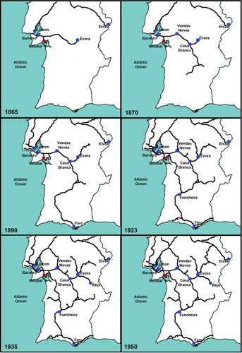
The regulation of railway construction in Portugal was one of the responsibilities of the Conselho Superior de Obras Públicas e Minas. This council was created in 1852.Footnote30 However, the Portuguese tracks were built through a combination of private enterprise and state intervention. In short, the main rail network of Portugal was intended to connect Lisbon to Oporto, Lisbon to Spain, and Lisbon to the south.Footnote31 Setúbal was included in the plans for the railway connection to the south and to the country’s border. Subsequently, following the construction of these two lines, an additional track was built, connecting the port of Setúbal directly to the south of Portugal in the end of the nineteenth century, crossing the Algarve region in the mid-twentieth century ().
Figure 2. Draft of the Setúbal railway connections in the Portuguese railway network (19th–20th centuries). Source: CitationSilveira, Alves, Lima, Alcântara, and Puig, Population and Railways in Portugal, 72. Designed by the author.
In 1854Footnote32, Setúbal was seen as one of the towns that could integrate the railway extension plans for Aldeia Galega (current Montijo) and Vendas Novas. Therefore, due to technical difficulties in building a river pier in Montijo, Setúbal was connected first to Barreiro. This branch was commissioned to João Pedro da Costa Coimbra, Francisco Melo de Soares Freitas, Jorge Gonçalves Franco and António Gomes Brandão, known as the Brazilians. This group created the Companhia Nacional dos Caminhos de Ferro ao Sul do Tejo (National Railway Company South of the Tagus), in 1854.Footnote33
A year later, the first train line in Portugal was inaugurated. It was built by Companhia Central e Peninsular dos Caminhos de Ferro em Portugal and it connected Lisbon to Carregado in 1856. Meanwhile, Setúbal grew and received the administrative title of ‘city’ (granted by King Pedro V). Finally, the tracks reached Setúbal in 1860.Footnote34 Nevertheless, the location of the train station was still under discussion.
When railways first appeared, train stations were typically built outside the urban fabric.Footnote35 In Setúbal, two proposals were made for the construction of the first railway station during the National Assembly debates: to build it close to the city, or 500 meters beyond its boundary. Even though, the latter was not well-regarded because it would complicate the movement of people and goodsFootnote36, this was the location where the trains first arrived. However, the railway arrival influenced the construction of the Avenida da Praia (Current Avenida Luísa Todi), an avenue built on an embankment that widened the riverbank.Footnote37
During the debates, António Serpa (1825–1900)Footnote38, Minister of Public Works at the time, suggested building a temporary train station to accompany the inauguration of the railway. Thus, with no station, Setúbal’s railway line was inaugurated in 1861. Due to construction delays and the need to replace equipment and several facilitiesFootnote39, the state took over the line, through a contract signed on August 6, 1861.Footnote40
However, as the state had no desire to manage the railway in the long-term, it proposed a sales contract to the Setúbal City Hall on May 15, 1862. According, to the proceedings of May 07, 1864, found in the Parliamentary Debates of the National Assembly Archive, the buyer would be responsible for: managing the railway between Setúbal, Barreiro, and Vendas Novas; covering the cost of extensions; completing the construction of the train station; extending the railway to the city of Évora and; building a railway between Beja and the Guadiana River.Footnote41
Although the purpose of the Portuguese railway was also to link Lisbon to Europe, both the Spanish railway strategies, and the English investors, ended up hindering the fulfilment of this task. A large part of the investment made in the construction of the railway in Portugal came from England. However, this funding slowed down the progress of the rails, as connecting the interior of Portugal with Europe could weaken the British monopoly on Portuguese maritime trade.Footnote42 This game of interests can be identified in the case of the Setúbal railway construction.
Bill no. 79 awarded the project of the Setúbal line to the British businessman Hardy Hislop in 1862. According to the contract, the train station of Setúbal should have been completed within four yearsFootnote43, but Hislop failed to honour his commitments and consequently, the British company, South Eastern Railway Company of Portugal, took over the project. The contract was signed by one of the company's directors, Alfred Cowan. However, the company was not performing well and the government soon realized that the lack of care for the railway management was related to a proposition made by the businessman Julius Beer.Footnote44 This representative of South Eastern Company asked for some changes to be made to the concession. After considerable discussion, the government agreed to the request, however, the company did not pay the first instalment, and the Executive Power cancelled the contract. Despite the mismanagement, Portugal wanted to avoid an international dispute. Thus, after a period of diplomatic tension, the Portuguese government accepted to pay South Eastern and retake possession of the railway infrastructure in 1869.Footnote45
The Setúbal train station was finally built beyond the city limitFootnote46, but no record found specifies the exact date its construction was completed. On examination of a photograph from mid-1890s, the station had a symmetrical masonry façade, i.e. a central building and two side buildings. This railway infrastructure was close to the city, on a place with ‘a great view of the city’Footnote47, but far from the port.
The first plans to connect the railway from the station to the port in Setúbal were designed approximately fifteen years after the opening of the railway. The design, by Cardoso Avelino, was submitted to the Ministry of Public Works on March 15, 1877. The official publication of the Chamber of Deputies (1877) stated that the new connection had the purpose of making the loading and unloading services more efficient and cost-effective, avoiding transhipment and overloaded transports.Footnote48 A public tender was launched on March 11, 1882. Among other things, this document mentioned the need to build a terminal railway station near the port. As consequence, the connection between the railway station and the port was authorized in 1883.Footnote49
Meanwhile, the cost of transportation between the port of Setúbal and its railway station was higher than between Setúbal port and Lisbon’s railway station.Footnote50 Consequently, services provided by the port of Setúbal were redirected to Lisbon; in addition to the railway, steam navigation, new roads, and the appearance of a new economy left the Setúbal port at a disadvantage.Footnote51 According to some theoreticians, this is one of the reasons why the population of Setúbal did not exceed 15,000 people for 20 years. Thus, despite the port and the urban growth having been reasons why the railway was built in Setúbal, the port's services had not been improved and the city's growth had not been accelerated after the arrival of the railway.
The connection between the railway and the port area
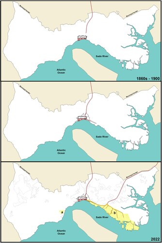
Construction works to connect the first railway station and the port of Setúbal began in 1904.Footnote52 The 1,800-meter connection between the railway station and the port was completed in 1908, being extended over the years ().
Figure 3. Draft of the port-rail infrastructure and urban growth of Setúbal in the current Municipal Territory. Red hatch: old port area (current fishing and recreational port area); yellow hatch: current industrial port area (a – Secil Terminal; b – other specialized port terminal facilities). Designed by the author.
Due to the extension of the railway line to the port area, the city lost a large square known as Praça do Quebedo (where a second station, designed by Corttinelli Telmo, was built in 1930Footnote53), and, after crossing the hills of the Sado riverbanks by means of a tunnel, the rails intercepted the ‘longest and most beautiful’ Footnote54 Portuguese avenue, Avenida Luísa Todi (the same avenue that had its construction boosted by the arrival of the railway).
Near Estrada da Graça, the road that separated the city from the railway and the port infrastructures, a number of shacks, some of which comprised domestic accommodation, were demolished in the port area.Footnote55 These urban sacrifices were justified by the implementation of a railway crossing the entire area of Fontaínhas, running parallel to the river, on the east of the urban area, so as to improve the rail services of the port. In contrast, the urban fabric on the west of the new railway line, remained unchanged, maintaining its orthogonal design. The main avenues, namely Avenida Luísa Todi and Avenida 5 de Outubro, running parallel to the river, were crossed by perpendicular narrow streets.
Meanwhile, the Sado Line, an extension of the port rail branch approved in 1903Footnote56, was under discussion in the National Assembly. This debate went on for a number of years, due to the presentation of different studies and hydrographic data. After the railway reached the port, João de Souza Calvet Pinto de Magalhães (1845–1924)Footnote57, Minister of Public Works, argued that the extension of Setúbal’s line to the Algarve region (in the south of Portugal) would reduce the costs and facilitate transportation, but many did not share his opinion. So, another line was proposed, passing through Valdera instead of Setúbal. However, the investment already made to expand the port of Setúbal, and the works already done to connect the port to the railway station were used as arguments against the second proposal.
Companies such as the Societé Belge de Mines d’Aljustrel, Direcção de Minas da Serra da Caveira, and French investors, Bartissol, wanted the Sado Line to cross Setúbal, because, though it was in need of improvements, it was the third most industrialized city in Portugal at the beginning of the twentieth century. They believed that the connection between this city and the Algarve region would boost the Portuguese economy by means of their companies and investments, namely in the salt-rich region between Macarena and Córrego do Carvão, the fishing industry, canned sardines, the cork industry, agricultural produce from Alentejo region, and tourism. Thus, in 1910, the City Hall and Companhia dos Caminhos de Ferro do Sul signed a contract to build this new railway station, called Setúbal-Mar station, and all the necessary infrastructure for its operations.
As confirmed by a document written in 1911 by the commission responsible for the Vale do Sado railway and addressed to the Minister of Development, the port became the main reason to build the Sado Line. After all, the port of Setúbal already competed with international ports. In addition, silt and dredging works in the Sado estuary allowed Setúbal to receive more ships. The commission also highlighted that this port was an infrastructure of great national importance.
The discussions over this line delayed improvements to the port. Construction was resumed only after the final decision regarding the passage of the line through Setúbal (June 1912).Footnote58 Works were interrupted once again by World War I and resumed in 1930. However, a preliminary study was presented to Direcção Sul e Sueste in 1921 and approved, subject to changes.
The Law no. 15/7 of 1923 created the Junta Autónoma das Obras do Porto e Barra de Setúbal e do Rio Sado (Autonomous Department), which was responsible for the port’s improvements. A new preliminary study of the railway was developed in 1926 by engineer Costa Serrão, a member of the Senior Board of Public Works, and approved by the Direção dos Caminhos de Ferro do Sul e Sueste.Footnote59 This project does not feature the station building since the engineer proposed that it should only be designed after the new dock was built.Footnote60 Conversely, as the internal layout of the new dock would depend on the station building, and the land surrounding the railway station would appreciate in value in line with the planning of the railway building entrances, in 1927, the Autonomous Department asked for a preliminary study of the final railway station project.Footnote61 Finally, on June 27, 1930, Højgaard & Schultz took over the construction of the building, working with Van Den Bosch & De Vries.Footnote62
Meanwhile, a general railway project was approved by Decree 18.190, on March 28, 1930. This project included a section connecting Alcácer to Casa Branca on the Sado Line. However, on August 25 that year, Sapec (a chemical and fertilizing company) questioned its construction, presenting a new proposal to the Minister of Commerce and Communications. In that plan, the connection between Setúbal and Casa Branca crossed Águas de Moura and Fonte, shortening the distance between the port and Upper Alentejo region by 2.6 km, and the distance between the port and Santa Suzana quarry by 2.2 km.
Two years passed and there was no decision concerning the connection between Setúbal and Casa Branca. Thus, on June 18, 1932, the Autonomous Department asked if the project would be implemented or not; this request mentions the lack of a project for the Setúbal-Mar station. Even in these circumstances, and with two years left to complete port improvement, the Autonomous Department asked the CEO of Companhia dos Caminhos de Ferro Portugueses to start the work of moving earth for the station near the port on January 9, 1932.Footnote63
A few days later, the Companhia dos Caminhos de Ferro Portugueses claimed that the final project for Setúbal-Mar station had been ready for a while. That same day, engineer Ruy Gomes Ulrich agreed to begin moving earth, reinforcing the existence of a final railway station project.
The documents found do not show details of a station building, but do identify its location, accompanied by the connections between the port and Setúbal’s main railways. According to A. de M. Cid Perestrello, the Port’s Chief Engineer, this connection was not detailed, but one of the six lines of the Sado Line heads towards the port ().
Figure 4. General layout of the Setúbal port developed by A. de M. Cid Perestrello in 1933. Source: Proceedings n. 588, Estação de Setúbal-Mar, Arquivo APSS. Adapted by the author.
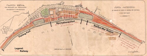
The line heading to the port area crosses the commercial port, where it splits into five branches: three of them go to the space destined to cork deposits, wood, cereal, salt, and other produce; one of them runs along one of the walls that encloses the Commerce Dock; and another branch runs behind this dock and splits into two other branches. One of the new branches served the space destined to store cedar wood and other building materials and other kinds of wood deposit, and the other one crossed the recreational port and the fishing port. With this configuration, the railway separated the Sado River from the city. However, the drawing shows roads crossing the railways near the port area.
Implementation of the railway became essential to ensure the port services. Thus, on March 12, 1934Footnote64, the Autonomous Department asked the Companhia Portuguesa dos Caminhos de Ferro for help to build the connection between the port and the Sado Line. This branch was meant to be 1600 meters long and to connect the Commercial Dock to the new station, as in .
Figure 5. Draft of the railway connection between the port and Sado Line, 1934. Source: Annex in Proceedings n. 589-Pasta A, in Arquivo da APSS. Adapted by the author.
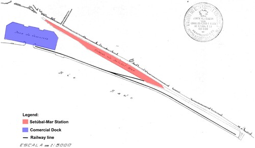
The Companhia Portuguesa dos Caminhos de Ferro signed a contract with the Autonomous Department on June 14. The construction of the new branch began on February 4, 1935, and it was inaugurated two months later. According to the document Carta n. 276/1934-35, the final project for Setúbal-Mar station was submitted and approved by the Autonomous Department in November 1931, but no register of this was found. Only a description of the building in the 10° Aditamento ao Aviso ao Público (10th Addendum to the Notice to the Public) A. N. 375, from April 25, 1935Footnote65, indicating the kilometre 29.865 of the Sado Line, between Fontaínhas-Sado and Cachofarra, as its location is available. This document also states that the station would not have a ticket office and it would only accept passengers without luggage. Although this station building was included in all the plans, it was never built. Reflecting the predominance of economic interests throughout the construction of the link between the railway station and the port area, the Setúbal-Mar station remained a space destined for loading and unloading goods.
The spatial organization of the port-rail infrastructure
As can be seen, the early twentieth century was a period of urban transformation in Setúbal. In addition to the port and industrial services, the south-east of the city became a railway area from 1908. Consequently, while the railway connections with the port and to the south of Portugal were being discussed, the entities responsible for the railway and port areas faced another challenge, that of organizing their territory.
The Conselho d’Obras Públicas demanded the construction of a barrier separating rail and port lands. According to Order n. 516/RP of 1983Footnote66, the limits of the railway and the port were approved based on a drawing from August 28, 1935. At the beginning, the Direcção Geral dos Caminhos de Ferro proposed that lands located between Estrada da Graça, and the new riverbank, should belong to the railway. The Conselho d’Obras Públicas did not accept the proposal, because it would not allow for a potential expansion of the port. Finally, the fence was built in land belonging to the port, but far from the riverbank.
Along the port-rail infrastructure, landfill, level-crossings, passenger shelters and a roof for embarking and disembarking platformsFootnote67 were built. The works intended to improve the port services and its relationship with the industrial area. Several level-crossings were built along the rails that ran parallel to Estrada da Graça, to give support to the factories, offering them access to the port. Between Fontaínhas and Vila Maria, along 1600 meters of railway, there were 11 private level-crossings and a public one ().
Table 1. Location of level-crossings. Source: Proceedings n. 588, in Arquivo APSS.
The railway company considered that the level-crossings were excessive and requested their removal. However, since this could cause financial damage to the factories that used them, the Autonomous DepartmentFootnote68 denied the request. Finally, on June 12, 1935, the Autonomous Department proposed the unloading of all fisheries produce at the extremities of the port area. This proposal would enable the construction of service roads capable of replacing most level-crossings; it would only be necessary to keep those shown on .
Table 2. The level-crossing proposed by the Autonomous Department. Source: Proceedings n. 588, in Arquivo APSS.
Despite the Autonomous Department's concern to assist with the running of Setúbal's industrial area, during the 1930s, due to the rudimentary production process of a number of industries located in Setúbal, and the increased competitiveness between canning companies, Setúbal underwent a process of deindustrialization. Thus, between 1934 and 1944 Setúbal lost 25 companies linked to maritime production. Nevertheless, freight transport continued to grow, thus the port started to attract companies and other industries, like Secil (cement) and Sapec (chemical and fertilizer). This led Setúbal to another period of industrialization that increased during the 1960s. As a result, the riverbank, from the commercial dock to the east (Mitrena, Praias do Sado/Manteigadas/Curvas, and Estrada do Alentejo)Footnote69, was industrialized, and, in 1966, the port’s commercial dock was improved, and some private docks were built.
However, the industrial growth did not continue. In the 1980sFootnote70, Setúbal became a part of a regional development programme due to some changes in the international market, and the impossibility of modernizing the industrial infrastructures of the city. As a result, the port services that until that period had used the whole riverbank, separating the city from the river, were concentrated in the south-eastern part of the urban fabric, where earthworks and the construction of better access by land were possible. The port infrastructure expanded: the Roll-On/Roll-Off terminals were built between 1985-1992, followed by the conclusion of the container terminal; in 2002 the port infrastructure welcomed a multipurpose terminal and continued to improve its services over the years. In 1989Footnote71, to ensure the modernization and expansion of port services, the Administração dos Portos de Setúbal e Sesimbra (APSS) was created.
The port was relocated because of the need to expand and modernize its services, not to improve urban life. Thus, the area vacated by the port subsequently declined. However, the new port occupied lands that were not attractive for urban activities, due to the natural characteristics of the terrain, which consisted of a narrow portion of land near a vertical drop of approximately 30 meters. To mitigate the impact of the relocation of port services, APSS developed some intervention projects for the riverbank, but none of them resulted in real urban transformations. In summary, the interventions made were the extension of the APSS headquarters building, the reorganization of an urban-port route, the construction of support buildings for fishermen and the elaboration of studies for the planning and expansion of the port.Footnote72
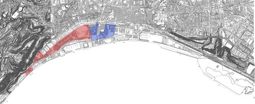
Even though the entire territory bordering the Sado river belonged to the port, the area from the eastern end of Albarquel beach until nearly the beginning of the commercial dock, including the area close to the fishing port and the recreational port, was integrated into the ‘waterfront’ concept (). Therefore, to bring citizens closer to the river, rehabilitation projects started to be developed to this area.
Figure 6. Topographical representation of Setúbal. Red: western waterfront; blue: eastern waterfront. Source: Seminário a Cidade e o Urbanismo | Município de Setúbal (mun-Setúbal.pt). Design by the author.
Thus, strategies for the development of sustainability in the urban fabric of Setúbal have been evolving along with discussions at global level. After the Agenda 21 on Environment (1992), a number of documents were developed on behalf of sustainable urban designs, like the Charter of European Cities and Towns towards Sustainability (1994), EU Framework Directive on ambient air quality (1996) and the European Spatial Development Perspectives of 1999. All of them were used as references for the Lille Declaration (September 12, 2000), which looks towards a ‘European Greenways Network’, by reconverting old infrastructures into greenways.
This document took into account the demands made for the provision and development of services to: facilitate non-motorized travel (to reduce congestion, noise and air pollution); design spaces for low-risk leisure activities (accessible to all and with beneficial effects to public health); encourage sustainable tourism; conserve and enhance local heritage and natural landscape; facilitate intermodal transport; and to increase the quality of urban and suburban life. Footnote73
In the early-twenty-first century, after the development of some joint plans between the APSS and the City Hall (Plano de Pormenor da Frente Ribeirinha de Setúbal of 1997 and of 1999), sustainability became a real part of the urban plan agenda of Setúbal. Thus, in 2001, as a part of the Polis Programme, the Programme of Urban Rehabilitation and Environmental Enhancement, the Strategic Plan of the Setúbal's Waterfront was designed. However, this plan was not implemented because the population did not agree with the high number of buildings designated for certain areas of the riverbank.
In 2004Footnote76, the Administração do Porto de Setúbal took responsibility for the rehabilitation of the area around the Fontaínhas dock and the construction of a recreational naval space. The project was approved on June 27, 2014.Footnote77 It considers the port as a crucial element, aiming for its integration into the urban fabric, and it is scheduled for completion in ten years. It was only after this project, in 2015, that Setúbal's waterfront was covered by the ARU, the Setúbal Urban Rehabilitation Area, which until then only considered the historic centre in projects of urban rehabilitation and enhancement.
Although the hill that separates the city from the port was not considered in ARU, in 2018 it was requalified. In partnership with the ENA, the Agência de Energia da Arrábida, the City Hall installed near the Jardim Camilo Castelo Branco (a garden integrated in the National Ecological Reserve, as an area of protection of the Escarpments of Santos Nicolau), the Energies Multisensory Garden. From this area, the citizens are able to see the river. However, when they go down the hill and reach the same topographic level as the riverbank, all they can see is a landscape composed of roads, railway, industrial constructions, and the port.
The Setúbal railway infrastructure accompanied the urban and the port improvements, and the city henceforth ranked second among the most important railway ports nationwide. According to the APSS, the rails placed in the city’s port area receive approximately 6000 trains per year and have been included in all the studies made to improve the urban area of the port since 1993. However, the first discussions about urban rehabilitation did not involve the railway infrastructure.
Thus, to consolidate and strengthen the city’s port activities and improve the city’s integration with the old port area were the goals of the rehabilitation projects developed throughout the years. The land occupied by the port services is marked by industries, rails, and a road close to a steep area. Currently, it is organized in two zones: covering part of the area where the Setúbal-Mar station’s building was planned, Zone 01 of the multipurpose terminal consists of the Tersado terminal, the Sadoport terminal, and the Ro-Ro terminal; and, further down the rail line, Zone 02 consists of the railway providing direct support to the Ro-Ro terminal and the Lisnave naval yard, and indirect support to the Termitrena terminal and the Teporset terminal.Footnote78
Some protocols for improving the operation of the port-railway infrastructure are being developed. An example, is the protocol signed between the APSS and Infraestruturas de Portugal (IP) in 2017.Footnote79 The agreement aimed to electrify and build new railways in the reception and goods dispatch areas and connect the port to the main railway line. The work developed by the APSS and the IP is now also related to the operating role Setúbal must play in the Corredor Internacional Sul (Southern International Corridor). This corridor is a railway line departing from Sines and arriving at the frontier between Portugal and Spain, from where it shall proceed to Madrid. Although there is no direct connection to Setúbal in the project, the existing railway lines will allow Setúbal to take advantage of this new route.
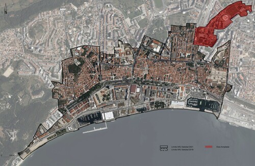
Allied to the objective of enhancing port services, the Setúbal Master Plan of 2020 (2020 PDM) includes environmental policies such as the Green Infrastructure (this concept emerged around the development of innovative approaches for biodiversity conservation), and initiatives to promote transportation logistics by decreasing the traffic of freight trucks. The rail area in the 2020 PDM is divided into the following sections: Area of Special Uses as an Area of Structural Infrastructures; Green Area as an Area of Protection and Environment and; Area of Economic Activities. In addition to this division, in 2021, a small part of the railway tracks became a part of the urban rehabilitation area of Setúbal (ARU), due to the inclusion of some neighbourhoods near by the railway in ARU ().
Figure 7. Representation of the Setúbal ARU overlap 2018 and 2021. Red: added area. Source: Diário da República, 2ª série, n. 74, p. 204.
A seminar organized by the IPFootnote80, José Castel-Branco, President of the Ports of Lisbon, Setúbal, and Sesimbra, referred to the industrial past of Setúbal as a unique feature of the city. As previously noted, the port area between Fontaínhas and Cachofarra is artificial land created by years of siltation and landfilling. Industries that operated there between the 19th and 20th centuries were built at the base of the hill near the riverbank. The industrial area was abandoned in the 1980s and 1990s, but José Castel-Branco contends that the area is now open to a new industrialization process, and that the Corredor Internacional Sul can be an opportunity to make that happen.
Conclusion
The historical analysis presented in this article explains the expansion of the railway infrastructure, and its connection to the port area, in Setúbal. The first plan for the construction of a direct link between these two means of transport was proposed fifteen years after the arrival of the railway. Thus, even though the interest to connect the railway and the port of Setúbal arose during the period of the implementation of the railway in the city, both infrastructures were planned separately.
Under the direction of the Portuguese-run Companhia Nacional dos Caminhos de Ferro ao Sul do Tejo, the railway arrived in Setúbal in 1860, connecting the city with the railway line that crossed the Alentejo region and was extended until the border between Portugal and Spain. However, the first railway station was built outside of the urban fabric and away from the port area, as a result of a conflict of interests at international level. The city's railway passed from the hands of the State to the hands of English investors, and did not develop until 1869, when the line became State-owned again. British funding deliberately slowed the progress of the rail network in Portugal in order to continue the British monopoly on Portuguese maritime trade. Because of this, the railway connection between the station and the port of Setúbal took almost thirty years to be built.
The first project was designed in 1877 under the management of the Ministry of Public Works, Commerce and Industry, but the authorization for the construction of the railway connection with the port was only signed six years later, in 1883. The works for the construction of this rail branch started even later, in 1904. During the 1910s the Sado Line was also built. This extended the port's railway to the Algarve region in the south of the country. The main reasons for establishing connections between the railway and the port were the need to reduce costs of transporting goods, and the prospect of extending the services of the port to the hinterland. Even the level-crossings were built according to the operation of the railway, the port and other industrial services.
The most significant urban impacts caused by the rail connection between the first railway station of Setúbal and the port were the loss of a large square, the intersection of the railway with Avenida Luísa Todi and the construction of a tunnel. The two first impacts were seen as urban sacrifices. However, after an industrial decline (in the 1940s), freight transport was able to attract companies and other industries to Setúbal, causing a second period of industrialization in the 1960s. Therefore, port services were able to continue to grow, while the urban fabric developed throughout the new railway infrastructure.
During the 1970s, discussions about sustainability and logistics emerged worldwide. These gave rise to the ‘waterfront’ concept. Consequently, after the relocation of port services to the eastern part of the riverbank in Setúbal, the municipality tried to develop the old port area as a ‘waterfront’. However, the first municipal authority attempts to intervene in the area failed, because even after deactivating its old infrastructure, the jurisdiction of the land fell under the port administration. Only after some protocols were agreed between the municipality and the port administration, did the urban functions of this area begin to improve. Thus, from 2001, the urban fabric of Setúbal established a direct relationship with the river.
Currently, the port-rail infrastructures are considered in Setúbal’s Master Plan. However, the spatial link between the city, the railway and the port has not been widely developed in urban theories. As in the past, level-crossings are still considered a ‘constraint’Footnote81 in Setúbal, and are not part of a mobility plan. Possibly due to this theoretical gap, the institutions responsible for new urban planning continue to deal with the railway and the port as isolated elements in the urban fabric, and even separated from each other.
By presenting the spatial connection between the port and the railway from a historical perspective, this study has attempted to expose whether the territorial impacts and difficulties of this connection were, and are, considered in urban planning. From the analysis of Setúbal, we could confirm that throughout history no urban studies have explained in a detailed way the relationship between the railway and the port in the city. The passage and installation of these infrastructures were responsibilities of their administrations, but the management of their impact on the city has often become the responsibility of the municipal power through rehabilitation and requalification plans.
Further reflections are required to establish guidelines for the creation of new urban, rail, and port integration plans. This knowledge could help Setúbal, and other port cities, to assure sustainable urban development. Since 2021Footnote82, Setúbal’s port and railway infrastructure have been improved; thus, it is an appropriate moment to enlarge the discussions in an attempt to provide an interface adapted to emerging urban needs.
Acknowledgements
The author would like to thank Patrícia Pombinho and the APSS (Administration of the Ports of Setúbal and Sesimbra), for all the support given to the research, and anonymous referees for their attention to evaluate and comment on the article.
Disclosure statement
No potential conflict of interest was reported by the author(s).
Additional information
Funding
Notes on contributors
Fernanda de Lima Lourencetti
Fernanda de Lima Lourencetti is an Architect graduated in 2011 at UNESP-Bauru/SP (Brazil) and holds a Master Erasmus Mundus TPTI - Technique, Heritage and Industrial Territory (Unversité Paris 1 Panthéon-Sorbonne, Università degli Studi di Padova and Universidade de Évora, 2015). She is currently finishing her PhD at University of Évora in a joint programme with Lisbon University called HERITAS – Heritage Studies.
Notes
1 «Declaração da Conferência das Nações Unidas sobre o Meio Ambiente Humano – 1972.»
2 World Commission on Environment and Development Future, Our Common Future.
3 «Declaração de Joanesburgo sobre Desenvolvimento Sustentável Das nossas origens ao futuro.»
4 European Commission, “Proposal for a Decision of the European Parliament and of the Council on a European Year of Rail”.
5 Capel, Los Ferro-carriles en la ciudad, 48.
6 See Cerdá, Teoría General de la Urbanización.
7 Geddes, Cities in Evolution, 192.
8 O'Flanagan, Port Cities of Atlantic Iberia, 04.
9 Ureña Francés; Pozueta Echavarri Los espacios portuarios en el planeamiento urbano, 73.
10 Isidoro, Marat-Mendes, and Tângari, The Portuguese railway in time and space, 364.
11 Alegria, A organização dos Transportes en Portugal.
12 Pinheiro, Ferrocarriles, ciudades y estaciones en Portugal, 42-62.
13 Isidoro, Marat-Mendes, and Tângari, The Portuguese railway in time and space, 364.
14 Cardoso, and Simal, and de Lima, The Lisbon and Seville stations.
15 Lourencetti, Morais, A Eletrificação da Estação Ferroviária do Cais do Sodré em Lisboa, 747-762.
16 Silveira Pereira, Os caminhos-de-ferro do sul e sueste.
17 Ribeiro, Moura, and Chorincas, Uma Metrópole para o Atlântico, 36.
18 Alegria, Maria Fernanda, A Organização dos Transportes em Portugal.
19 Ribeiro, Beloto, A organização do território urbano, 02.
20 Ribeiro, Beloto, A organização do território urbano, 03.
21 Ibid., 06.
22 Pereira, Portais de globalização, 227–239.
23 Ribeiro, Beloto, A organização do território urbano, 04.
24 Meyer, City and Port, 47.
25 Fernandes; Sousa. A definição de frente ribeirinha, 113-131.
26 Câmara Municipal de Setúbal, 2020 PDM, 445.
27 Casas CitationTorres, Tradición e innovación en el sistema de la Geografia, 420.
28 Junta Autónoma, Breve notícia, 08.
29 Perestrello, O Pôrto de Setubal, 08
30 Isidoro, Marat-Mendes, and Tângari, The Portuguese railway in time and space, 367.
31 CitationSilveira, Alves, Lima, Alcântara, and Puig, Population and Railways in Portugal, 73.
32 CitationSMCI – Câmara Municipal de Setúbal, Setúbal Jornal Municipal, 26.
33 Silveira Pereira, Os caminhos-de-ferro do sul e sueste.
34 Quintas, Porto de Setúbal, 30.
35 Pinheiro, Cidades e caminho-de-ferro, 54.
36 Assembleia da República, Document n. 006.
37 Câmara Municipal de Setúbal, 2020 PDM, 453.
38 Assembleia da República, Document n. 010.
39 Assembleia da República, Document n. 130.
40 Assembleia da República, Document n. 099.
41 Assembleia da República, Document n. 091.
42 Isidoro, Marat-Mendes, and Tângari, The Portuguese railway in time and space, 368.
43 Assembleia da República, Document n. 099.
44 Silveira Pereira, Os caminhos-de-ferro do sul e sueste.
45 Ibid.
46 Arquivo Fotográfico Américo Ribeiro (PT/AFAMR/AMR-15756).
47 Sousa, As Linhas Férreas e o Porto de Setúbal, 617.
48 Assembleia da República, Document n. 049.
49 CitationArquivo Distrital de Setúbal, Legal Charter of 1883, document 2/444/pt. 47/31.
50 Assembleia da República, Document n. 009.
51 Anonymous Citation01, Indústria Portuguesa, 346-347.
52 Assembleia da República, Document n. 039.
53 Anonymous Citation02, Réde do Sul e Sueste, 594.
54 Biblioteca Municipal de Setúbal, Document FDL R-703.
55 Quintas, Porto de Setúbal, 30-31/134.
56 CitationSMCI – Câmara Municipal de Setúbal, Setúbal Jornal Municipal, 26.
57 Assembleia da República, Document n. 056.
58 Junta Autónoma, Breve notícia, 1933, 12.
59 Arquivo APSS, Proceedings n. 588, Estação de Setúbal-Mar.
60 Arquivo APSS, Proceedings n. 588, Letter n. 62 of May 1927.
61 Arquivo APSS, Proceedings n. 588, Letter n. 244 of December 29, 1927.
62 Sousa, As Linhas Férreas e o Porto de Setúbal, 617.
63 Arquivo APSS, Proc. n. 581 (1930 a 1935), Ofício n. 145/1931-1932.
64 Arquivo APSS, Proceedings n. 589-Pasta A, Document n. 342/1933-34-452.
65 Arquivo APSS, Proceedings n. 589-Pasta A.
66 Arquivo APSS, Proceedings n. 588, Order n. 216/RP of 1983.
67 Arquivo APSS, Proceedings n. 588, Document 424/1934-35.
68 Arquivo APSS, Proceedings n. 589-Pasta A, Letter n.327/1934-35.
69 Câmara Municipal, 2020 PDM, 506.
70 Sousa, and Carneiro, A reconversão da Frente Ribeirinha de Setúbal, 102/103.
71 Sousa, and Carneiro, A reconversão da Frente Ribeirinha de Setúbal, 103.
72 Ibid, 106.
73 Matos, Lourencetti, Reusing railway infrastructures, 16.
74 Sousa, and Carneiro, A reconversão da Frente Ribeirinha de Setúbal, 106.
75 Ibid, 107.
76 Diário da República, Decree-Law n.° 225/2004, I série-A, n. 285, December 6, 2004, 6972.
77 Diário da República, 2 série – n.° 162 – Auguste 25, 2014, 22087.
78 APSS, S.A., Info folder.
79 Anonymous Citation03, Melhoria dos acessos ferroviários.
80 CitationInfraestruturas de Portugal, O Corredor Internacional Sul – A sua Importância Estratégica.
81 CitationInfraestruturas de Portugal, O Corredor Internacional Sul – A sua Importância Estratégica.
82 Anonymous Citation04, Porto de Setúbal reforça ferrovia.
References
- Alegria, Maria Fernanda. A Organização dos Transportes em Portugal (1850-1910) – as Vias e o Tráfego. Lisbon: Centro de Estudos Geográficos, 1990.
- Américo Ribeiro in Arquivo Fotográfico. Américo Ribeiro DIBIM | DCDJ | Câmara Municipal de Setúbal (PT/AFAMR/AMR-15756). Photograph “Estação do caminho de ferro de Setúbal, [1896?]”, unknown author.
- Anonymous 01. “A valorização industrial da região de Setúbal”, Indústria Portuguesa, Lisboa (1960): 346-347.
- Anonymous 02. “Réde do Sul e Sueste”. Gazeta dos Caminhos de Ferro, 22° do 47° ano, n. 1127 (Lisbon: 1933): 594.
- Anonymous 03. “Melhoria dos acessos ferroviários ao Porto de Setúbal em andamento”, in Revista Cargo, (Loures, 2017). Open Access: https://revistacargo.pt/acessos-ferrovia-setubal/.
- Anonymous 04. “Porto de Setúbal reforça ferrovia: eletrificação dos acessos aos terminais arrancará em 2021”, in Revista Cargo, (Loures, 2021). Open Access: https://revistacargo.pt/porto-de-setubal-reforca-ferrovia-electrificacao-dos-acessos-aos-terminais-arrancara-em-2021/.
- APSS-Administração dos Portos de Setúbal e Sesimbra, S.A. Info folder “Ordenamento e Expansão do Porto de Setúbal, Resumo do Zoneamento Portuário”, 2001.
- Assembleia da República, Document n. 006. Proceedings of March 07, 1860, 55-56, in Arquivo dos Debates Parlamentares da Assembleia da República.
- Assembleia da República, Document n. 009. Proceedings of January 14, 1881, 105, in Arquivo dos Debates Parlamentares da Assembleia da República.
- Assembleia da República, Document n. 010. Proceedings of May 12, 1860, 116, in Arquivo dos Debates Parlamentares da Assembleia da República.
- Assembleia da República, Document n. 039. Proceedings of March 13, 1904, 06, in Arquivo dos Debates Parlamentares da Assembleia da República.
- Assembleia da República, Document n. 049. Proceedings of March 16, 1877, 657, in Arquivo dos Debates Parlamentares da Assembleia da República.
- Assembleia da República, Document n. 056. Proceedings of August 05, 1908, 06, in Arquivo dos Debates Parlamentares da Assembleia da República.
- Assembleia da República, Document n. 091. Proceedings of May 07, 1864, 1459, in Arquivo dos Debates Parlamentares da Assembleia da República.
- Assembleia da República, Document n. 099. Proceedings of June 21, 1862, 1729, in Arquivo dos Debates Parlamentares da Assembleia da República.
- Assembleia da República, Document n. 130. Proceedings of August 12, 1861, 2241-2251, in Arquivo dos Debates Parlamentares da Assembleia da República.
- Arquivo APSS - Administração dos Portos de Setúbal e Sesimbra. Proceedings n. 581 (1930–1935), Ligações ferroviárias com o Porto de Setúbal.
- Arquivo APSS – Administração dos Portos de Setúbal e Sesimbra. Proceedings n. 588, Estação de Setúbal-Mar – Correspondência sôbre a sua instalação, construção e exploração.
- Arquivo APSS – Administração dos Portos de Setúbal e Sesimbra. Proceedings n. 589-Pasta A, Vias Férreas do Porto. Ligação da estação de Setúbal-Mar com o cais do porto de Comércio (1934–1945).
- Arquivo Distrital de Setúbal. Legal Charter of 1883, document 2/444/pt. 47/31.
- Garnier, Tony. Bibliothèque Sainte-Geneviève Archive. Une cité industrielle. Étude pour la construction des villes, 1917.
- Biblioteca Municipal de Setúbal. Documento FDL R-703 (1911). Exposição apresentada ao Exmo. Ministro de Fomento pela Commissão encarregada de promover a construção do caminho de ferro do Valle do Sado por Setúbal.
- Câmara Municipal de Setúbal, Plano Diretor de Setúbal. (Setúbal, 2020), 2020.
- Capel, Horácio. Los Ferro-Carriles en la Ciudad. Rede Técnicas y Configuración del Espacio Urbano. Barcelona: Fundación de los Ferrocarriles Españoles, 2011.
- Cardoso de Matos, Ana, Julián Sobrino Simal, and Fernanda de Lima Lourencetti. The Lisbon and Seville stations: their place within railway station typology and their impact on the organization of urban space”, in EdA Esempi di Architettura International Journal, vol.1 (Italy, 2020): Open Access: 15. EDA_2020_CARDOSO_SOBRINO_DE LIMA.pdf (esempidiarchitettura.it).
- Cerdá, Ildefonso. Teoría General de la Urbanización y Aplicación de sus Principios y Doctrinas á la Reforma y Ensanche de Barcelona. (Madrid: Imprenta Española, Torija, 1867).
- Declaração da Conferência das Nações Unidas sobre o Meio Ambiente Humano. The United Nations Conference on the Human Environment, 1972. http://www.suape.pe.gov.br/images/publicacoes/legislacao/1._1972_Declaracao_Estocolmo.pdf, 1972.
- Declaração de Joanesburgo sobre Desenvolvimento Sustentável Das nossas origens ao futuro. https://cetesb.sp.gov.br/proclima/wp-content/uploads/sites/36/2013/12/decpol.pdf, 2002.
- Diário da República. 2ª série, n. 74 de 16 de abril de 2021: Aviso n. 6936/2021, parte H.
- Diário da República. 2 série – n.° 162 – Auguste 25, 2014, 22087.
- Diário da República. I série-A, n. 285, December 6, 2004, Decree-Law n.° 225/2004, pp. 6972.
- European Commission. “Proposal for a Decision of the European Parliament and of the Council on a European Year of Rail” (Brussels, 2021).
- Fernandes, André, and João Sousa. “A definição de frente ribeirinha: subsídios para uma delimitação conceptual e espacial”, in Geografia e Ordenamento do Território, Revista Electrónica, 10 (Porto: Centro de Estudos de Geografia e Ordenamento do Território, 2006): 113–131.
- Geddes, Patrick. Cities in Evolution – An Introduction to the Town Planning Movement and to the Study of Civics. London: Williams & Norgate, 1915.
- Howard, Ebenezer. To-morrow: A Peaceful Path to Real Reform. London: Swan Sonnenschein, 1898.
- Infraestruturas de Portugal. O Corredor Internacional Sul - A sua Importância Estratégica: Stream em direto, 2021. https://www.youtube.com/watch?v=oCQA6jdianQ.
- Isidoro, Inês de Azevedo, Teresa Marat-Mendes, and Vera Regina Tângari. “The Portuguese Railway in Time and Space – Mapping Phases of Growth, Stagnation, and Decline (1845–2015).” Planning Perspectives 33, no. 3 (2018): 363–384.
- Junta Autónima das Obras do Pôrto de Setúbal e do Rio Sado. Breve Notício Sòbre as Obras do Pôrto de Setúbal. Setúbal: Biblioteca Publica Municipal de Setúbal, 1933.
- Lourencetti, Fernanda de Lima, and Rita Morais. “A Eletrificação da Estação Ferroviária do Cais do Sodré em Lisboa: Uma Perspetiva Urbana.” In La Electricidad y la Transformación de la Vida Urbana y Social, edited by Capel, Horacio and Zaar, Miriam, 747–762. Barcelona: Universidad de Barcelos/Geocrítica, 2019.
- Matos, Ana Cardoso de, and Fernanda de Lima Lourencetti. “Reusing Railway Infrastructures in the Spirit of Circular Theory. A Contribution to an Operational Concept”, in Vitruvio.” International Journal of Architecture, Technology and Sustainability 6, no. 1 (2021): 12–23.
- Meyer, Han. City and Port: The Transformation of Port Cities: London, Barcelona, New York and Rotterdam. Rotterdam: International Books, 1999.
- Notteboom, T. E., and J.-P. Rodrigue. “Port Regionalisation: Towards a New Phase in Port Development.” Maritime Policy and Management 32 (2005): 297–313. doi:10.1080/03088830500139885.
- O'Flanagan, Patrick. Port Cities of Atlantic Iberia, c. 1500–1900. Aldershot, England: Ashgate Publishing Limited, 2008.
- Pereira, Hugo Silveira. “Portais de Globalização: Portos e Caminos de Ferro no Contexto Colonial Portugués: (c. 1870–c. 1910).” Revista Portuguesa de História XLIX 49 (2018): 227–239.
- Perestrello, Afonso De Melo Cid. O Pôrto de Setúbal (Setúbal: Junta Autónoma das Obras do Pôrto e Barra de Setúbal e do Rio Sado, 1934).
- Perestrello, Afonso De Melo Cid. General Layout of 1933, Proceedings n. 588 – “Estação de Setúbal-Mar – Correspondência sôbre a sua instalação, construção e exploração”, in Arquivo da Administração dos Portos de Setúbal e Sesimbra.
- Pinheiro, Magda. “Ferrocarriles, Ciudades y Estaciones en Portugal, de Finales del Siglo XIX al Siglo XXI”, in Transportes.” Servicios y Telecomunicaciones 38 (2019): 42–62.
- Pinheiro, Magda. Cidades e Caminho-de-Ferro. Lisbon: Centro de Estudos de História Contemporânea Portuguesa, 2008.
- Richardson, Benjamin Ward. Hygeia – a City of Health. London: Macmillan & Co, 1876.
- Quintas, Maria da Conceição, Porto de Setúbal: um actor de desenvolvimento. (Setúbal: APSS – Administração dos Portos de Setúbal e Sesimbra, SA, 2011).
- Ribeiro, Rafael Rossetto, and Gislaine Elizete Beloto. "A organização do território urbano a partir da relação porto-cidade e seu reflexo na forma urbana”, in urbe. Revista Brasileira de Gestão Urbana (Brasil: 2020). doi:10.1590/2175-3369.012.e20190267
- Ribeiro, José Manuel Félix, Francisca Moura, and Joana Chorincas. Uma Metrópole Para o Atlântico. Lisbon: Fundação Calouste Gulbenkian, 2015.
- Silveira Pereira, Hugo. Os Caminhos-de-Ferro de Sul e Sueste e o Relatório do Engenheiro C. F. White (1868). Évora: Cidehus, 2018. doi:10.4000/books.cidehus.3379.
- Silveira, Luís Espinha da, Daniel Alves, Nuno Miguel Lima, Ana Alcântara, and Josep Puig. “Population and Railways in Portugal, 1801–1930”, in História, Património e Infraestruturas do Caminho de Ferro: Visões do Passado e Perspetivas do Futuro (Lisboa, 2014): 63–89.
- Soria y Mata, Arturo. Ferrocarril tranvía de circunvalación de Madrid a Canillas, Hortaleza, Fuencarral, Vicálvaro, Vallecas, Villaverde, Carabanchel y Pozuelo: datos y noticias referentes a su construcción y explotación. Madrid: Est. Tipográfico "Sucesores de Rivadeneyra", 1892.
- Sousa, J. Fernando de. “As Linhas Férreas e o Porto de Setúbal. Apontamentos históricos”, Gazeta dos Caminhos de Ferro, 23° do 46° ano, n. 1103 (Lisbon: 1933): 617.
- Sousa, João Figueira, and Ernesto Carneiro. “A reconversão da Frente Urbano-Portuária de Setúbal”, in Mediterrâneo, n. 10/11 (Lisboa: Instituto Mediterrânico da Universidade Nova de Lisboa, 1997): 101-118.
- SMCI – Câmara Municipal de Setúbal. “Pouca terra pouca terra … ”, in Setúbal Jornal Municipal, ano 15, n. 15 (Setúbal: PROS-Promoções e Serviços Publicitários, Lds. 2015): 26.
- Torres, José Manuel Casas. “Tradición e innovación en el sistema de la Geografia”: Opúsculos Geográficos – Síntese e Método – Pensamento Geográfico, 2ª ed. (Lisbon: Fundação Calouste Gulbenkian, 2014): 420.
- Ureña Francés, José, and Julio Pozueta Echavarri. ““Los Espacios Portuarios en el Planeamiento Urbano”, in Actas del Simposium Territorio, Puerto y Ciudad (Sevilha) (1986): 73–81.
- World Commission on Environment and Development Future. Our Common Future. Oxford University Press. https://archive.org/details/ourcommonfuture00worl, 1987.