
Abstract
Augmented reality is a new technology that merges the virtual and the real worlds and offers important support in all planning processes. Using mobile devices, planning information can be implemented with smart and participative solutions for a dynamic fruition of cultural heritage [Brondi, R., Carrozzino, M., Tecchia, F., & Bergamasco, M. (2012) Mobile augmented reality for cultural dissemination, in: P. Nesi & R. Santucci (Eds), ECLAP 2012 Conference on Information Technologies for Performing Arts, Media and Entertainment, pp. 113–118 (Firenze: Firenze University Press); Hatzelhoffer, L., et al. (2012) Smart City in Practice: Innovation Lab Between Vision and Reality (Jovis). Technologies are important tools because they make a city smart by making concrete contributions to trigger dynamic processes of place-based development. Three important factors improve urban planning fruition: participation in the early stages of listening and co-design; enlightened governance and new technology. This paper (1) presents the actual possibilities and challenges of augmented reality in the field of cultural heritage, (2) describes a simulation of one case study in a neighbourhood in Cagliari (Italy), by proposing customized paths with the aim of promoting cultural tourism and (3) explains the benefits of using augmented reality in touristic and place-based processes based on the case study.
Introduction
Numerous studies have clearly shown that within urban planning, communication is undergoing a profound renewal because of a joint set of factors: namely, emerging and ubiquitous technological developments, a greater citizen awareness in safeguarding the territory (Blondiaux, Citation2008; Lewanski, Citation2013) and the rise of bottom-up models in the planning process enabling interactive, incremental and inclusive processes (Jenkins, Citation2007; Rheingold, Citation2008).
In light of this comprehensive social and technological change, urban planners and political administrators have to be able, through smart decision-making, to inform and involve people (residents, tourists and city users in general) in the planning processes while also raising people's awareness of the cultural heritage. This might be addressed through tools that allow a ‘three-dimensional’ understanding of the planning or heritage contents and that aid in making information available to different non-expert users. Classic two-dimensional communication does not allow users to have the same perception of actual planned changes because of people's varying basic knowledge and backgrounds. Where 3D models may represent a solution to this problem for some, others voice objections related to the complexity of 3D models or the burden of creating them (Azuma, Citation1999). However, both 2D and 3D models, users are always outside of the representation, which causes users to remain spectators rather than participants. Augmented reality (AR), by generating a composite overlap of interactive virtual elements of reality, provides good support for human sensory perception augmentation and a better understanding of the phenomenon that is taking place (Dunleavy & Dede, Citation2014). Today, the rapid development in the ubiquitous computing (UC) paradigm, especially in the mobile environments of the latest generation, now allows anyone with a computer (or simply a smartphone) to be connected in real time and to get information from the virtual world that implements (‘augments’) reality through the overlapping of layers of information. Additionally, city users can experience the urban space in new ways by correlating it with digital information in forms that were impossible or unimaginable in the recent past.
According to the literature, smartphones or AR enabled PC tablets that are applied to cultural heritage can help cultural and urban development in two main ways: (i) by overlaying a map with drawings, graphics, physical models, audio files and digital simulations that help non-expert users understand culturally complex phenomena and (ii) by integrating virtual elements with what appears on site through visualizations of past historically accurate landscape architecture that helps to increase the awareness of a place on the basis of its historical (as opposed to merely visible) peculiarity. This is a new culture of fulfilling the potential of a place and promoting its tourism industry: it opens up a territory where all buildings can potentially create networks, which positively affects the production of competitive common goods and common services. Put simply, it helps to create a new form of cultural tourism that falls within the broader field of cultural computing (Tosa et al., Citation2005).
The cultural message is thus reinvented by using an integrated camera to provide real-time information about a site or monument, or about the route that generic users are taking or even about the buildings in front of them. Thus, it is possible to give the user the opportunity to visit lesser known, but equally important, memorials, sites or museums. New ways to use public spaces are introduced that increase the attractiveness of sites like museums.
It is precisely the latter, an example of a mix between reality and virtual reality, where a service is offered to users that provides information that is much more comprehensive and easier to interpret than that provided by any other instrument or device. This is because it allows users to interact with the actual environment while displaying virtual information on the same time (Piersantelli, Citation2010).
The interest in the cultural sector demonstrated by some groups of people (sector operators, intellectuals, students, visitors, tourists, etc.) can definitely be incisive and define the intentions behind their wanting these ‘special’ services. In fact, although the sector of cultural tourism in Italy has strong potentiality, their enthusiasm can contrast the negative trends that in recent decades have characterized the Italian tourist economy. The Strategic Plan for Tourism Development in Italy (2013) indicates among the causes of the Italian sector decline: (i) the insufficient use of digital sales channels; (ii) the lack of service applications for smartphones and tablets and (iii) a more general lack of a digital strategy for tourism sector. In order to overcome these gaps, the same Strategic Plan identifies targeted and specific actions, such as the development of applications for mobile devices specifically targeted at foreign tourists, who can integrate information related to logistics with those properly cultural (museums, exhibitions, etc.). Service integration and interoperability of applications seem to be issues on which to focus to relaunch national tourism.
Considering these assumptions, the following paper briefly describes the fast development of new techniques and tools for promoting cultural tourism. This paper then focuses on a platform simulation that is accessible in a ‘cloud’ environment that can be used to develop ‘smart’ services that provide a useful prototype for the fruition of cultural heritage while paying special attention to the driving forces of the economy and local tourism.
Augmented Reality: A Theoretical Framework and Its Application in the Tourism Field
The progress of technology is determined by the degree of user involvement, which, for a passive spectator, becomes part of the same technology, effectively interacting with and guiding practical development. This was very clear to Ivan Sutherland, the father of the current field of virtual reality research.Footnote1 He, through his experiments, developed the first virtual reality device in as early as 1968. The device's feature was that it was ‘see-through’, which allowed it to simulate a scenario while also continuing to show the surrounding reality in the background (Castiello, Citation1995, p. 139). It is precisely this property that distinguishes virtual from augmented reality. Over the years, and (thanks to Thomas Caudell and David Mizell—who officially coined the augmented reality expression) in Citation1992 in particular, the natural evolution of the concept of virtual reality (immersion in a virtual world that simulates reality) led to that of augmented reality (the overlap of virtual elements with the real world), passing through mixed reality (superimposition of virtual elements onto reality, but without knowing in advance which is dominant in respect to the virtual reality). Numerous experiments were also carried out (Azuma, Citation1999; Regenbrecht & Specht, Citation2000; Gleue & Dähne, Citation2001; Newman et al., Citation2001; Vlahakis et al., Citation2001; Rohs et al., Citation2007; Morrison et al., Citation2009; Angelopoulou et al., Citation2012) in the field of crowdsourced/volunteered production of geospatial data or geovisualization based on AR technologies (Liarokapis et al., Citation2005, Citation2006; Ghadirian & Bishop, Citation2008; Firmino & Duarte, Citation2010; Nebiker et al., Citation2010; Furht, Citation2011; Bishop, Citation2011; Graham et al., Citation2012; Graham, Citation2013; Graham & Zook, Citation2013). For instance, Ghadirian and Bishop (Citation2008) proposed an approach for displaying an urban landscape defined by maps made with geographic information system tools, and they have integrated the urban changes with AR.
Liarokapis et al. (Citation2005, Citation2006) proposed a set of services defined by, and localized within, AR technologies that are useful for the ‘urban navigation’ of city users. Nebiker et al. (Citation2010) used existing 3D urban modelling to propose an overlap with AR technologies through the so-called ‘cloud point’ that identifies main points of interest (POIs). Graham and Zook (Citation2013), finally outlined the concept of augmented reality as a medium that, influenced by four typologies of power relations, can represent a place through the constant enactment and remaking of multiple subjective realities. These typologies refer to the capacity of the social production of augmented realities and the transparent nature of code and consist of the following: (1) the distribution of user-generated content; (2) communication power—namely the power to create, interpret, recirculate and repackage content; (3) code power—namely the opaque sorting of information and (4) the timeless power of the technology and/or the flattening of time.
In other words, the process of creating maps and location-sensitive information is important not only in terms of original cartographic practices, but also in terms of the designer's ability, which can allow users to remake or recontextualize geospatial information. The developer's construction of a temporal compression has to synchronize the in-virtual temporality and an in-the-moment experience of that reality (Graham & Zook, Citation2013, pp. 469–471).
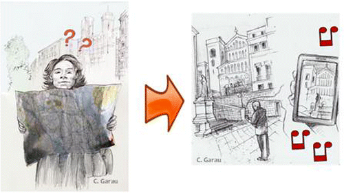
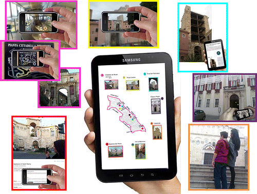
Today, augmented reality is preferred because it is considered more able to use digital information and new technologies to promote and enrich reality ‘with material and virtual experience[s]’ rather than completely replace reality with virtual environments (Furht, Citation2011; Fiasconaro & Guiducci, Citation2012; Graham & Zook, Citation2013). Augmented reality has been applied in various sectors, but I will focus on how it has developed in the context of cultural tourism. The constant evolution of technological solutions in the world of cultural sciences has prompted cities to upgrade their cultural tourism promotion, which has always been supported by important international organizations like ICOMOS, UNESCO and the World Tourism Organization. This interest has led to a change in the mode of communication, from classic traditional forms, such as tourist guides and paper maps, to current communication technology products (Figure ).
Thus, a new urban cultural tourism culture emerged that aimed to improve the experience of the generic user. The territory as a whole has assumed the role of a complex ‘museum’. That is, the association of the term museum with that of the territory is mainly translated in time as the synergistic promotion of physical ‘objects’ (places and institutions of culture, such as museums, archaeological sites and parks, archives, libraries and monumental complexes) with virtual technologies.
The urban space, associated with informational spaces (Castells, Citation1989; Stock, Citation2011), becomes a place where digital technologies (and often lines of coded algorithms) bring out the complex cultural apparatus of a city through the dense and overlapping layers of representation (Kitchin & Dodge, Citation2011). The purpose of the synergy between real and virtual is to consolidate and enhance place-based economic development, culture and the quality and integration of local resources while respecting their historical identities. Tourism products are developed to include more cultural offerings through a balanced dosage of the enhancement of places, competition, cooperation and coordination between various involved institutional actors.
It should be underlined, however, that while it may be necessary to use smarter technologies to address complex urban challenges and to allow for effective and efficient governance (Kanter & Litow, Citation2009), integrating advanced technologies with the cultural landscape is not enough to promote cultural heritage to tourists. It is, in fact, necessary to add supportive policies, platforms of governance and monitoring managed by a committee to implement the promotion and development of technological applications. Only in this way can new technologies lead to (1) shared experimentation, (2) a willingness to integrate augmented material and immaterial information to give a sense of ‘completeness’ to places with a historical-cultural identity and (3) a process of mutual learning between the tourist and cultural or historical landmark.
Augmented Reality Applied to Mobile Cultural Heritage
Applying the latest technologies to the field of cultural heritage should be seen as valuable not only for the individual, but also, by extension, for the cultural or historical landmark. This is the first prerequisite for the development of a grassroots model developed by generic users who decide to approach landmarks from a cultural heritage perspective, becoming a ‘DIY tourist’ and creating territorial induced effects and a measurable impact on the territory. This role is not imposed on generic users; the aim is try to get generic users to approach cultural heritage in the manner best suited to them.
Just over 10 years ago, the applications of augmented reality, which valourized the territory by making it an interactive museum that is usable in the open were only possible through the use of a stationary computer or a helmet connected to portal equipment (e.g. ARCHEOGUIDE, created in 2001 and then experienced on-site at Olympia in 2004. It is still in use [Fiasconaro & Guiducci, Citation2012]). Today, the same technology is given to the user through a mobile device in the form of a smartphone, which serves as an ideal platform for the applications of AR (Angelopoulou et al., Citation2012). The excellent applications that allowed this information revolution, and the subsequent use of cellular devices rather than PCs, are represented by the invention of the ‘app’. The system, based on functioning audio guides, frees the user from the need of a personalized guide, allowing him the opportunity not only to choose what to see and what information to hear but also to focus entirely on enjoying the cultural landmark.
Technological progress has made it possible to move beyond pilot or research projects: a series of toolkits that use AR technologies have been developed and marketed and experimental applications abound, such as the SmartMuseum of 2009 (Ruotsalo et al., Citation2009), the Nokia City Lens of 2012, Tuscany + of 2010 (Linaza et al., Citation2012), AR Media (Inglobe Technologies, Citation2011) or even the different evolutions of Layar (Citation2009) and Layar Creator (Citation2012). Their more or less evolved functioning contributes, once the smartphone camera is pointed, to viewing layers of information on the screen that overlap with current reality. The information content is created previously as POIs that other users have added. It is possible, for instance, to observe an expanded view of the surrounding area or to choose the type of information that is displayed: commercial, health, tourism, culture, etc. The user can refine the displayed information through some display options or remain on a particular POI. Another useful application is Streetmuseum (2010), developed by Thumbspark and created by the London Museum. It allows a historical perception of the city of London through the display of historical images that are visible once the generic user points the smartphone to a generic street where there is a POI identified by the museum (Jones et al., Citation2012). Street museum also allows the user the opportunity to see the POIs in advance and thus pre-plan tourist paths.
These new technologies, integrated with services like Google Art Project (http://www.googleartproject.com), could lead to a new cultural ‘museum’ of the city: not only is it possible to get to the places listed on the site (for free), but the service can also be exploited, for example, by integrating the information suggested on the Google Art Project site with other useful services for all city users. To this could be added the potential of a wiki or crowdsourcing project (Howe, Citation2006, Citation2009; Brabham, Citation2009; Goodchild, Citation2009) that appropriately uses the practices of tagging, folksonomies (the term, from folk and taxonomy, refers to an online cataloguing system with tags made by the community that connect physical spaces, such as museums, places or objects) and even user-created content (Hellin-Hobbs, Citation2010).
In this way, ‘technical’ production is implemented by collecting information using a method of mass collaboration through so-called Volunteered Geographic Information (VGI) (Goodchild, Citation2007), where groups of people create, manage and disseminate spatial data (Sui, Citation2008; Sui et al., Citation2013). Any consumer-user is thus transformed into a potential producer-user. This also allows for the differentiation of cultural offerings based on demand (for instance, through strategies for identifying target audiences) and the community, in terms of groups of individuals instead of basic numbers (Simon, Citation2010). While the private sector already uses the Internet on mobile phones as a channel for sales and marketing, mobile applications as part of city and tourism marketing are fairly rare. Of course, there is almost no local community in Italy that does not have Internet access, but, in view of the developments in mobile devices and their applications, there is a need to overcome the static information of the Internet.
A Case Study: A Smart Walk in Castello (Cagliari, Italy)
Considering the cited cases, it is evident that new technological frontiers offer new opportunities to the planner, public administration and city users that grant the ability to employ innovative tools for the construction of a virtual urban scenario integrated with the physical one by virtue of the contribution of AR. In this paper, a pilot application is presented that is available for download on smartphones or PC tablets. This pilot application not only adds value to tourism in Castello, one of the four historical neighbourhoods of Cagliari, Italy (Figure ), but also to planners or local administrators by accurately defining valuable cultural goods. The city of Cagliari is among the six finalists vying for the title of the European Capital of Culture 2019 and has met the first selection criteria due to the city's demonstrated willingness to pursue institutional cooperation in the field of culture (http://www.cagliari-sardegna2019.eu/en/).
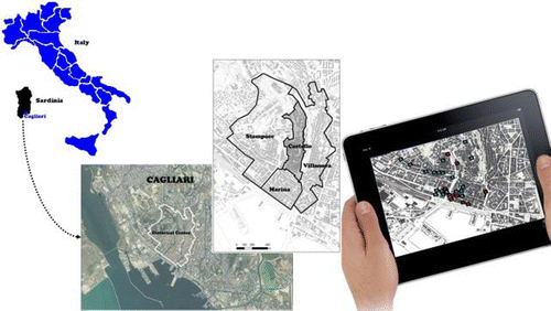
The choice of the Castello district is based mainly on its high concentration of identifiable, historical and cultural landmarks, but is also due its city layout urban plan, which has remained practically unchanged since the Pisan medieval period. Its artistic and cultural condition is the result not only of a long historical process towards which tourists converge but also, if not especially, the awareness of the high value of its assets and their need to be protected and transferred to future generations.
The study of the app has tried to take into account what was documented in the ‘Smart Cities Manifesto’, which was drafted during the international event ‘Apps for Smart Cities’ held in Amsterdam on 29 March 2012. The Manifesto indicates seven key elements that must be applied to the smart cities app: (1) sensitivity, made possible with special sensors; (2) a connection to sensitive information on the web; (3) accessibility to all users; (4) UC, which allows access to the system through a mobile device at any time and place; (5) a connection with social networks; (6) the ability to share any object that is not exclusively made up of data and (7) the visibility of the system not only through the mobile device but also in the physical environment (Vianello, Citation2013).
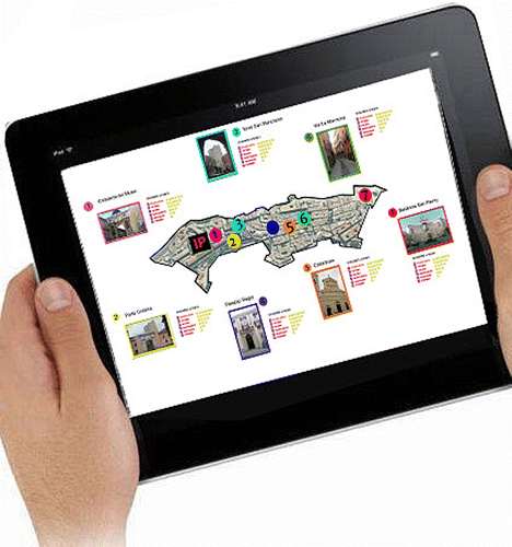
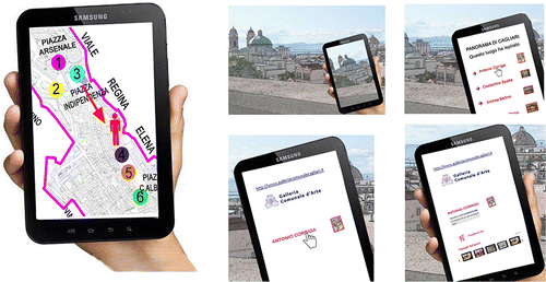
The main objective is based on the development of a plurality of paths and IPs (home paths translated from the Italian Inizio Percorsi) where for each one a tour has been hypothesized that should answer the unknowns that often accompany the ‘new user’ of a site: (1) which artistic and cultural heritage site is more worth visiting and (2) whether the time available is sufficient to visit any given artistic or cultural landmark. Through a simple user query that involves the user's own characteristics (age, physical ability as it relates to the physical demand of visiting the site, etc.), the software suggests lists that enable the unsure user to view a variety of information set out according to thematic and geographical proximity (from closest to farthest) that is connected to multiple POIs in ‘smart walks’. If, however, the user is more certain and knows what he or she would like to visit but does not know its surroundings, the application calculates the time of arrival at a certain place, the time required to visit it and places it on a route that incorporates more cultural heritage landmarks (Figure ). This has become important because the generic use of these places is increasingly manifesting itself as an extemporaneous factor, which, owing to cruise ships and low-cost flights, is also characterized by very short periods of stay.
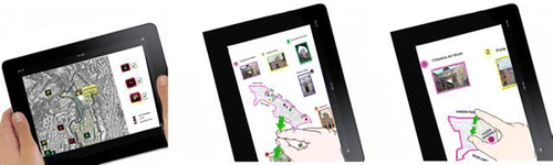
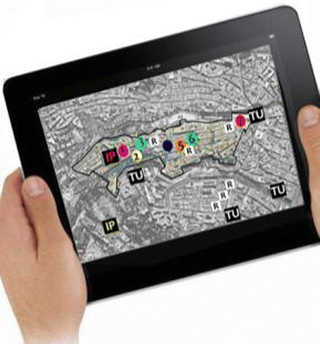
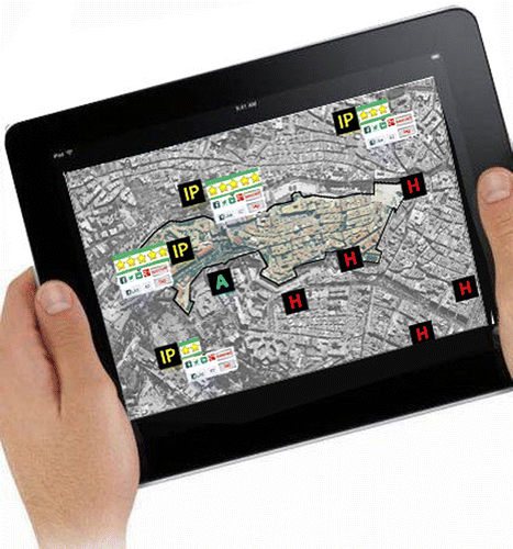
Moreover, the experience gained by a user is shared with other users, thus helping to implement the system for both insiders, who can make improvements based on user complaints, and generic users. In fact, generic users who enrich the portal in terms of quantity and quality of information (because it is subject to the monitoring of all), may choose to follow one path rather than another based on the feedback and comments left by their predecessors (Figure ). The system is therefore based on the concept that the current amount of information available online for the tourist, or for the generic user with little free time available, is dispersed, not readily available and is filtered through checkpoints that can be summarized as follows: (a) base maps, (b) tourist facilities and tourist accommodation information resources (restaurants, cafes, hotels, guest houses, etc.), (c) home paths (IP) and (d) transport utilities (Figure ).
Once the path is chosen, the device provides the user with an overview of the route. After the user has arrived at a point on the path and framed it with his device, the image is overlaid with the data from a multi-channel, multi-lingual platform that provides information, guidance, support, assistance, infotainment and an online shop (Figure ). In this way, a model of consultation and use is put into practice that employs digital tools and channels for broadcasting and interactive storytelling. It is a model of information sharing and transmedial narrative consumption. This app is the model, as described above, because it offers users access to experiences that blend—often in new, pleasant, engaging and cultural ways—elements of (1) expert knowledge, (2) their own and (3) non co-present others’ experiences and memories. All of them constitutes past, present and future real, narrative and virtual possible worlds.
This model would also allow an evaluation of the intangible cultural heritage currently linked to the landmark that is subject to the risk of extinction (music, songs, sounds, rhymes, spoken dialect, oral histories), facilitating its dissemination and bequeathal to future generations (Ahmad, Citation2006).
Once moved away from the monument or cultural POI, the device automatically shows the user's position and, using global positioning system and global system for mobile communications, allows the user to continue along the path. After a visit, the device allows the user to rate each POI on the quality of service offered along a scale of values ranging from an extremely negative assessment, defined by the term ‘poor’, up to an extremely positive one, defined by the term ‘excellent’, with intermediate values defined as ‘mediocre’, ‘sufficient’, ‘good’ and ‘very good’ (Figure ).
Users can also insert tags, images or comments, as well as promote knowledge of the landmark through ways that are unique to the conventional paradigm of cultural heritage. This feedback is then modulated according to an inclusive and participative approach (Figure ). Although this approach does not present an innovative model in the context of urban planning tools (Comerio, Citation1985; Balducci, Citation1991; Davidoff, Citation2001; Garau, Citation2011, Citation2013), it shows how interest has been renewed by virtue of the potential effectiveness of new technologies.
The incremental process leading to the construction of knowledge, by the constant acquisition of information from the community through VGI, is a fundamental principle in the application under study. However, although it is a field that presents innovative application possibilities, it is necessary not to underestimate some problems that beset it, including, for example, the quality of VGI that inevitably leads to the classification of users (Coleman et al., Citation2009). In fact, it can happen that (i) data collected voluntarily lacks proper localization (caused by the inexperience of general users), (ii) difficulties occur in drawing the same information because it overlaps and blends to interact with other layers of information or (iii) the reliability of volunteer users can easily become questionable. This particularly happens when there is no filter on incoming information, which then makes it impossible to trace the inaccurate information at a later time. Certainly, considering the voluntary nature of the data, the issues are problematic and difficult to resolve. That said, allowing these issues to remain unresolved will lead to a sub-par quality of information, even if intervention is conducted ex ante through preventive measures or ex post by instituting corrective measures.
The path described above promotes tourism on a small scale, which is only foreseeable for those cultural and geographical areas that already enjoy a strong power of attraction at national and international levels and have various types of visitors (from short-term visitors, typified by cruise ship times, to the long-term visits of experts with more in-depth interests). In Sardinia, for example, this application may be considered for the ancient Nuraghe of Barumini (the most important archaeological site in Sardinia, which has been declared a World Heritage site by UNESCO), which attracts a large influx of visitors each year—the demand exists, is consistent and consolidated. The historic district of Castello, even with its highly valued cultural resources, aims to earn a prestigious position similar to that of Sardinia by beginning at a local level through the integration of a number of cultural systems. The demand exists but individual places do not have a great number of visitors; however, Castello's integrated development could ensure the economy of the area. The path described is, for the sake of simplicity, set in a small area and is one of many possible paths that express the identity of the historical and artistic heritage of the historic district.
For the Castello district, an advanced virtual realization of cultural heritage by consumer-users might include the entire old city, which is integrated with the system of parks and historical mansions, or it might venture into the urban expansions of the nineteenth and twentieth centuries to help visitors understand the most significant architectural and urban planning characteristics and episodes of the city, with a few episodes of the post-war and contemporary city that belong to a wider selected area. This would mean a new way of reading the space of the city and a new model of organization that leads to a widespread knowledge of historical and artistic heritage.
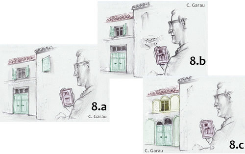
Through appropriate agreements with the municipality, it is also possible to use applications, which, owing to interactivity, will be able to faithfully reconstruct or approve architectural or urban projects before they are carried out by introducing augmented reality into these fields. This capability can also be used for generic historical buildings, giving the user the possibility of moving around inside a site that is currently undergoing transformation. For example, a user sees a building (Figure ), identifies it and—using his or her smartphone—reads about the transformations of that building (Figure ). Then, in the future, if the user wants to return to the site he or she can see what he or she had only previously imagined thanks to augmented reality (Figure ). In the same way, it will be possible to compare the present and the future with the historical development of the memorial places of that particular site.
In collaboration with galleries and museums, the visit could begin with a generic panorama so spectacular that it arouses the admiration and awe of the viewer, who might, for example, frame it with the smart device and immediately acquire a list of artists who have been inspired by that same view, together with related art galleries that exhibit paintings by these artists. The generic user could go to admire one of the paintings on site or access the ‘online shop’ (with the shopping cart icon) or the museum bookshop (where it is sold in the catalogue of that painter) and ultimately decide whether to buy a copy—all directly from that initial view on the user's smart device (Figure ). The marketing of merchandise is certainly an added value that this app would provide, especially in museums that are characterized by local production—the quality of which would be ‘guaranteed’ by the museum itself, thus enabling self-financing.
Conclusions
Currently, the extension of the city into digital space has changed the organization and use of physical space. This modernization of the traditional city has led to the passage from a reading of its physical infrastructures as separately related to each other, to a new approach in which they are integrated and connected with people and systems. Although technology is put to the service of the city, this work has shown, with some evidence, that pervasive technological innovation alone cannot guarantee a network logic that involves dialogue and reconciliation between public and private sectors.
Network management, developed and constantly monitored by all city users, can instead exploit all the cultural resources of an area. In this perspective, on the one hand it would be desirable to create a network of cultural heritage that merges together into a single information channel, thus allowing the composition of paths (virtual or not) and promoting an integrated local tourism—or, at the very least, the development of marketing and tourism (integrated advertising campaigns, combination and single tickets, etc.). On the other hand, this paper has suggested some reflections regarding the benefits of the use of such technologies. The increase of knowledge that this research suggests is inherent in the networked society's structure because it provides the opportunity not only to disseminate different fields of knowledge and culture, but also to place them in a critical relationship with each other, share them and start a virtuous circle of growth and economic development.
Moreover, from a didactic-educational point of view, the possibility to create immersive environments can expand the attractiveness of various cultural landmarks not only for the tourist-user, but also for resident and student-users. In fact, it is possible to create conditions that encourage and enable users to approach cultural heritage and its structures with less deferential, more dynamic, and sometimes more in-depth attitudes, which may cause users to bond with the territory and its cultural heritage in its broadest sense.
This, however, is difficult in Italy due to a culturally profound conservationist perspective that presupposes a clear distinction between intrinsic cultural value and economic value. In addition, it is a fairly rigid regulatory framework that causes undeniable uncertainties in entrusting competences to public entities: cultural heritage preservation is entrusted to the central level (State) while the enhancement is delegated to State-Regions (LD 42/2004, known as Code of Cultural Heritage and Landscape [art. 117, third paragraph]). The Code also distinguishes between ‘institutions and places of culture’ (museums, libraries, archives, archaeological sites and parks, monumental complexes) and ‘institutions and public places belong to these institutions’ (art. 101–102). Only for the latter, the Code provides for an enhancement focused on agreements between local authorities to define common strategies and to process consequential plans (art. 112, fourth paragraph), in the absence of which ‘each public entity is required to ensure the enhancement of goods which still has availability’ (art. 112, sixth paragraph).
For these reasons, I have used this paper to consider the importance of thinking, not only in theoretical but also in practical terms, about how the cutting-edge topic of AR technology can be integrated with notions of ‘cultural landmarks’, ‘the protection of cultural heritage’, ‘the promotion of cultural heritage’ and ‘cultural tourism’. This may be an opportunity for Cagliari to address these issues as they apply to a larger territory than that used in this paper, while observing the enthusiasm, motivation and dedication with which the public authorities of Cagliari have undertaken to make the city the European Capital of Culture.
Notes
1. Ivan Sutherland, father of computer graphics, in 1965, aimed to reveal the real world beyond the screen of the machine. In 1968, he made a first rudimentary form of video helmet which shows a cube stylized backdrop of the real world and senses movements in correspondence with the movement of the head. (Beccaria, Citation2005, pp. 11–12; Soro, Citation2008, pp.290–291).
Related Research Data
REFERENCES
- Ahmad, Y. (2006) The scope and definitions of heritage: From tangible to intangible, International Journal of Heritage Studies, 12(3), pp. 292–300.
- Angelopoulou, A., Economou, D., Bouki, V., Psarrou, A., Jin, L., Pritchard, C., & Kolyda, F. (2012) Mobile augmented reality for cultural heritage, Mobile Wireless Middleware, Operating Systems and Applications, 4th International ICST Conference, Mobilware 2011, London, UK, June 2011. Revised selected papers. Lecture notes of the Institute for Computer Sciences, Social Informatics and Telecommunications Engineering, LNICST, Vol. 93, pp. 15–22 (Berlin: Springer)
- Azuma, R. T. (1999) The challenge of making augmented reality work outdoors, in: O.Yuichi & T.Hideyuki (Eds) Mixed Reality: Merging Real and Virtual Worlds, pp. 379–390 (London: Springer-Verlag)
- Balducci, A. (1991) Disegnare il futuro: il problema dell'efficacia nella pianificazione urbanistica[Shaping the Future: The Problem of Effectiveness in Urban Planning] (Il Bologna: Mulino)
- Beccaria, A. (2005) I pionieri della frontiera digitale. Internet: dagli esordi al World Wide Web[The Pioneers of the Digital Frontier. Internet: From the Beginnings to the World Wide Web] (Viterbo: Stampa Alternativa)
- Bishop, I. D. (2011) Landscape planning is not a game: Should it be?Landscape and Urban Planning, 100(4), pp. 390–392.
- Blondiaux, L. (2008) Le nouvel esprit de la démocratie. Actualité de la démocratie participative[The New Spirit of Democracy. Current Developments of Participatory Democracy] (Paris: Seuil)
- Brabham, D. C. (2009) Crowdsourcing the public participation process for planning projects, Planning Theory, 8(3), pp. 242–262.
- Castells, M. (1989) The Informational City: Information Technology, Economic Restructuring, and the Urban Regional Process (Oxford: Blackwell)
- Castiello, U. (1995) Tecniche sperimentali di ricerca in psicologia[Experimental Techniques of Research in Psychology] (Padova: Piccin Nuova Libraria)
- Caudell, T. P., & Mizell, D. W. (1992) Augmented reality: An application of heads-up display technology to manual manufacturing processes, Proceedings of 1992 IEEE Hawaii International Conference on Systems Sciences, pp. 659–669.
- Coleman, D. J., Georgiadou, Y., & Labonte, J. (2009) Volunteered geographic information: The nature and motivation of produsers, International Journal of Spatial Data Infrastructures Research, 4, pp. 332–358.
- Comerio, M. (1985) Il community design oggi, Spazio e Società, 1985, n.31/32.
- Davidoff, P. (2001) Advocacy and pluralism in planning, in: S.Campbell & S. S.Fainstein (Eds) Readings in Urban Theory, 2nd ed. (Oxford: Blackwell Publishers)
- Dunleavy, M., & Dede, C. (2014) Augmented reality teaching and learning, Handbook of Research on Educational Communications and Technology, pp. 735–745 (New York: Springer)
- Fiasconaro, V., & Guiducci, S. (2012) Realizzazione di un Prototipo di Realtà aumentata applicato ai siti archeologici, in: L.Bordoni (ed.) AI & Cultural Heritage, pp. 39–47 (Roma: ENEA)
- Firmino, R., & Duarte, F. (2010) Manifestations and implications of an augmented urban life, International Review ofInformation Ethics, 12, pp. 28–35.
- Furht, B. (2011) Handbook of Augmented Reality (London: Springer)
- Garau, C. (2011) Esperienze di pianificazione partecipata [Experiences in Participative Planning], in: Ricerche di Architettura. Atti delle giornate di studio 8-9 aprile 2011 – Dipartimento di Architettura di Cagliari, pp. 10–17 (Roma: Gangemi Editore)
- Garau, C. (2013) Processi di piano e partecipazione[Planning Processes and Citizen Participation] (Roma: Gangemi Editore)
- Ghadirian, P., & Bishop, I. D. (2008) Integration of augmented reality and GIS: A new approach to realistic landscape visualisation, Landscape and Urban Planning, 86, pp. 226–232.
- Gleue, T., & Dähne, P. (2001) Design and implementation of a mobile device for outdoor augmented reality in the ARCHEOGUIDE project, VAST 2001 – Virtual Reality, Archeology, and Cultural Heritage International Symposium, Athens, pp. 161–168.
- Goodchild, M. F. (2009) NeoGeography and the nature of geographic expertise, Journal of Location Based Services, 3, pp. 82–96.
- Goodchild, M. F. (2007) Citizens as voluntary sensors: Spatial data infrastructure in the world of web 2.0, International Journal of Spatial Data Infrastructures Research, 2, pp. 24–32, Available at http://www.geoinformatics.cn/wp-content/uploads/citizensasvoluntarysensors.pdf.
- Graham, M. (2013) Geography/Internet: Ethereal alternate dimensions of cyberspace or grounded augmented realities?The Geographical Journal, 179(2), pp. 177–182.
- Graham, M., & Zook, M. (2013) Augmented realities and uneven geographies: Exploring the geo-linguistic contours of the web, Environment and Planning A, 45(1), pp. 77–99.
- Graham, M., Zook, M., & Boulton, A. (2012) Augmented reality in the urban environment, Transactions of the Institute of British Geographers, New Series, 38(3), pp. 464–479.
- Hellin-Hobbs, Y. (2010) The constructivist museum and the web, pp. 72–78 (London: EVA). Available at http://ewic.bcs.org/content/ConWebDoc/36052.
- Howe, J. (2009) Crowdsourcing: Why the Power of the Crowd Is Driving the Future of Business (New York: Crown Publishing Group)
- Howe, J. (2006) The rise of crowdsourcing, Wired, 14(6), pp. 1–4.
- Inglobe Technologies. (2011) ARMedia Augmented Reality Plugin 2.2 now available. Available at http://www.inglobetechnologies.com/en/news/fullnews.php?id=33 (accessed 10 June 2014).
- Jenkins, H. (2007) What is Civic Media? in: Non Verbatim Transcript of a Talk given at MIT, September 20, 2007. Available at http://web.mit.edu/commforum/forums/civic_media.html (accessed 10 June 2014).
- Jones, P., Eloy, S., Ricardo, R., & Dias, M. (2012) Architectural rehabilitation and conservation processes informed by augmented reality, in: H.Achten, J.Pavlicek, J.Hulin & D.Matejdan (Eds) Digital Physicality – Proceedings of the 30th eCAADe Conference, Vol. 2, 12–14 September 2012, Czech Technical University in Prague, Faculty of Architecture (Czech Republic) pp. 411–418.
- Kanter, R. M., & Litow, S. S. (2009) Informed and Interconnected: A Manifesto for Smarter Cities. Working Paper 09-141. Available at http://www.ctg.albany.edu/publications/journals/hicss_2012_smartcities/hicss_2012_smartcities.pdf.
- Kitchin, R., & Dodge, M. (2011) Code/Space: Software and Everyday Life (Cambridge, MA: MIT Press)
- Layar. (2009) LAYAR: The First Mobile Augmented Reality Browser Premiers in the Netherlands. Available at https://www.layar.com/news/blog/2009/06/16/press-release-the-first-mobile-augmented-reality-browser-premiers-in-the-netherlands/ (accessed 10 June 2014).
- LayarCreator. (2012) Layar Creator Places the Power of Interactive Print at Everyone's Fingertips. Available at http://www.layar.com/pr/creator/ (accessed 10 June 2014).
- Lewanski, R. (2013) Institutionalizing deliberative democracy: The ‘Tuscany laboratory’, Journal of Public Deliberation, 9(1). Article 10. Available at http://www.publicdeliberation.net/jpd/vol9/iss1/art10 (accessed 10 June 2014).
- Liarokapis, F., Brujic-Okretic, V., & Papakonstantinou, S. (2006) Exploring urban environments using virtual and augmented reality, Journal of Virtual Reality and Broadcasting, 3(5), pp. 1–13.
- Liarokapis, F., Greatbatch, I., Mountain, D., Gunesh, A., Brujic-Okretic, V., & Raper, J. (2005) Mobile augmented reality techniques for geovisualisation, Proceeding of the 9th International Conference on Information Visualisation, pp. 745–751.
- Linaza, M. T., Marimón, D., Carrasco, P., Álvarez, R., Montesa, J., Aguilar, S. R., & Diez, G. (2012) Evaluation of mobile augmented reality applications for tourism destinations, in: Information and Communication Technologies in Tourism 2012, Springer Vienna, pp. 260–271.
- MorrisonA., OulasvirtaA., PeltonenP., LemmeläS., JacucciG., ReitmayrG., NäsänenJ., & JuustilaA. (2009) Like bees around the hive: A comparative study of a mobile augmented reality map, in: Proceedings of the 27th International Conference on Human Factors in Computing Systems (CHI 2009), pp. 1889–1898.
- Nebiker, S., Bleisch, S., & Christen, M. (2010) Rich point clouds in virtual globes – A new paradigm in city modeling?Computers, Environment and Urban Systems, 34(6), pp. 508–517.
- Newman, J., Ingram, D., & Hopper, A. (2001) Augmented reality in a wide area sentient environment, Proceedings of the 2nd IEEE and ACM International Symposium on Augmented Reality (ISAR 2001), pp. 77–86.
- Piersantelli, G. (2010) Colpo d'occhio sulla Realtà Aumentata [Glance on augmented reality], Notiziario Tecnico Telecom Italia, n. 2.
- Regenbrecht, H., & Specht, R. (2000) A mobile passive augmented reality device, Proceedings of the International Symposium on Augmented Reality (ISAR 2000), pp. 81–84.
- Rheingold, H. (2008) Using partecipatory media and public voice to encourage civic engagement, in: L.Bennet (ed.) Civic Life Online, pp. 97–118 (Cambridge, MA: McArthur Foundation)
- Rohs, M., Schöning, J., Raubal, M., Essl, G., & Krüger, A. (2007) Map navigation with mobile devices: Virtual versus physical movement with and without visual context, Proceedings of the 9th International Conference on Multimodal interfaces, ICMI, pp. 146–153.
- Ruotsalo, T., Mäkelä, E., Kauppinen, T., Hyvönen, E., Haav, K., Rantala, V., Frosterus, M., Dokoohaki, N., & Matskin, M. (2009) Smartmuseum: Personalized context-aware access to digital cultural heritage, Proceedings of the International Conferences on Digital Libraries and the Semantic Web 2009 (ICSD2009), Trento, Italy. Available at http://www.smartmuseum.eu/index.html.
- Simon, N. (2010) The Participatory Museum. Santa Cruz. Available at http://www.participatorymuseum.org/read/.
- Soro, A. (ed.) (2008) Human Computer Interaction. Fondamenti e Prospettive (Milano: Polimetrica)
- Stock, W. G. (2011) Informational cities: Analysis and construction of cities in the knowledge society, Journal of the American Society of Information Science and Technology, 62(5), pp. 963–986.
- Sui, D. S. (2008) The wikification of GIS and its consequences: Or Angelina Jolie's new tattoo and the future of GIS, Computers, Environment and Urban Systems, 32(1), pp. 1–5.
- Sui, D. S., Elwood, S., & Goodchild, M. F. (2013) Crowdsourcing Geographic Knowledge: Volunteered Geographic Information (VGI) in Theory and Practice (Dordrecht: Springer)
- Tosa, N., Matsuoka, S., Ellis, B., Ueda, H., & Nakatsu, R. (2005) Cultural computing with context-aware application: Zenetic computer, Lecture Notes in Computer Science, 3711, pp. 13–23.
- Vianello, M. (2013) Smart Cities. Gestire la complessità urbana nell'era di Internet[Smart Cities. Managing Urban Complexity in the Internet Era] (Rimini: Maggioli Editore)
- Vlahakis, V., Karigiannis, J., Tsotros, M., Gounaris, M., Almeida, L., Stricker, D., Gleue, T., Christou, I., Carlucci, R., & Ioannidis, N. (2001) ARCHEOGUIDE: First results of an augmented reality, mobile computing system in cultural heritage sites, Proceedings of Virtual Reality, Archaeology, and Cultural Heritage International Symposium (VAST01), pp. 131–140.