
ABSTRACT
Global and national strategy emphasises land use planning as a key mechanism for disaster risk reduction (DRR). The practice of planning for natural hazards is devolved to local levels, making the capacity of local government critical for achieving strategic DRR goals. This study assessed the capacity of local governments in Australia to plan for natural hazards. Many Local Government Areas (LGAs) had satisfactory or good hazard planning provision, but remoteness, land area and council size influence poor hazard planning provision. Strategic intent for land use planning as a DRR mechanism is unlikely to be successful in many LGAs without first addressing place-based capacity constraints on hazard planning.
1. Introduction
As disaster resilience strategy has expanded over recent decades, land use planning, which articulates and regulates relationships between development and hazards, has consequently grown in strategic importance (UNDRR, Citation2015; COAG, Citation2011; NZ Government, Citation2019). At a global level, land use planning compliance and regulation is a key component of disaster risk reduction and resilience strategy (United Nations Office for Disaster Risk Reduction (UNDRR), Citation2015). At a national level, the focus is on developing guidance for localised land use planning for hazard mitigation and disaster resilience (PIA, Citation2018; FEMA, Citation2013; AIDR, Citation2020). At a state level, governments continue to refine land use policy in response to major disaster events, leading to recommendations for revised local planning provisions (QRA, Citation2012; Kornakova et al., Citation2017). Actions at these levels of government trickle down to local government, which is responsible for implementing higher-level directives through local policy provisions, and ensuring compliance with those policies at the development-hazard interface. While global, national, state and local bodies all have an interest in the contribution of land use planning to disaster risk reduction and disaster resilience, implementation and practice is largely devolved to local governments.
Local government capacity for implementing land use planning policy is therefore critical to achieving disaster risk reduction and disaster resilience outcomes (Lyles et al., Citation2014; Torabi et al., Citation2017). However, many factors influence the capacity of local governments to implement policy, and these factors can differ markedly among councils. Relatively wealthy local councils generally have access to greater planning resources, resulting in higher-quality hazard mitigation plans (Berke et al., Citation1999). Local councils with limited resources, often located in rural areas, can be less comprehensive in planning for local hazard risk (Berke et al., Citation1999; Frazier et al., Citation2013; Horney et al., Citation2017). It has been argued that state governments should moderate these capacity disparities through ‘funding and other incentives’ to boost the ‘local capacity-building resources’ of disadvantaged councils (Berke et al., Citation2014, p. 313). Varied local capacity for policy development and implementation, and the scope for moderation by the states, can be supported by a comparative assessment of local government capacity and its effects on natural hazard policy outcomes (e.g. Berke et al., Citation2014; Horney et al., Citation2017).
Commensurate with other comparative studies, geographic, organisational and policy factors are expected to create diverse conditions and challenges for hazard planning in Australia. There were 564 Australian Local Government Areas (LGAs) in 2015 when this evaluation commenced. These LGAs vary dramatically in land area (the smallest is 1 km2; the largest more than 370,000 km2), population (the smallest has less than 100 people, the largest more than 500,000), and degree of remoteness (141 metropolitan, 346 rural, and 77 remote LGAs). The councils that govern LGAs also vary substantially in size, ranging from as little as seven to over 7,000 staff. While each of the eight Australian State and Territory governments impose a degree of uniformity on policy settings, local government capacity for policy implementation, review and refinement may also contribute to the effectiveness of hazard planning.
This study assesses the capacity of local governments in Australia to plan for natural hazards, and examines whether differences in hazard planning capacity are influenced by geographic and organisational factors. This is pursued via an Australia-wide quantitative evaluation of planning policy for natural hazards in each LGA, and examination of the relationships between hazard policy provision and local-government geographic and organisational factors. The assessment identifies combinations of policy provision and local government capacity that might trigger a need for resourcing assistance to achieve goals of disaster risk reduction and resilience.
2. Land Use Planning, Local Capacity and Government Coordination
The emergence of a resilience perspective in global disaster risk reduction (DRR) strategy has seen an increased focus on government coordination to enhance local capacity. Prior to the strategic emphasis on resilience, the Yokohama Strategy promoted international cooperation to ‘strengthen national capacities and capabilities and … national legislation’ (IDNDR, Citation1994, p. 5). A decade later, when the Hyogo Framework refocused DRR strategy around resilience, there was a marked emphasis on localised goals: ‘communities and local authorities should be empowered to manage and reduce disaster risk by having access to necessary information, resources and authority to implement actions for disaster risk reduction’ (UNISDR, Citation2005, p. 5). The subsequent Sendai Framework for Disaster Risk Reduction 2015–2030 strives to boost and integrate capabilities across different scales of government, harnessing ‘the coordinating role of national and federal State Governments’ to ‘empower local authorities and local communities to reduce disaster risk, including through resources, incentives and decision-making responsibilities’ (UNDRR, Citation2015, p. 10). In short, DRR strategy has evolved to emphasise inter-governmental coordination with the express goal of enhancing capacity for disaster resilience at the local scale.
Australian commitments have kept pace with international developments. The Council of Australian Governments made improvement of DRR policy a national priority (COAG, Citation2009), leading to the National Strategy for Disaster Resilience (NSDR) which guides whole-of-government effort towards ‘action-based resilience planning to strengthen local capacity and capability’ (COAG, Citation2011, p. 2). To exemplify those goals, the NSDR includes a case study of coordination in the ‘NSW Government’s approach to building capacity’, where state authorities ‘identify local governments that are overwhelmed’ by DRR responsibilities, and contribute expert assistance in a consultative way to those local councils (COAG, Citation2011, p. 21). Ultimately, the NSDR seeks to expand coordination of all tiers of government – local, state and national – so that they contribute to localised capacity for disaster resilience. The recent National Disaster Risk Reduction Framework (NDRRF) continues to urge support for ‘locally-led and owned place-based’ DRR efforts (Australian Government, Citation2018, p. 9).
Land use planning has grown in strategic importance as DRR strategy has evolved towards local resilience (King, Citation2006; Lyles et al., Citation2014). The Hyogo Framework introduced land use planning as a ‘priority for action’ as part of its shift to local capacity (UNISDR, Citation2005, p. 12). Australia’s resilience approach included a focus on ‘developing and implementing effective, risk-based land management and planning arrangements’ (COAG, Citation2009); an objective that persists in the NSDR (COAG, Citation2011, p. 11). The NDRRF also considers land use planning a critical part of inter-sectoral coordination in Australian risk governance (Australian Goverment, Citation2018). As the principal instrument for managing land use and development, land-use planning is crucial for disaster risk reduction at the local scale (Godschalk, Citation2003, Citation2010). While some argue that ‘planning is the only discipline … that can play this integrating role’ in DRR (March & Dovers, Citation2017, p. 242) valid questions remain about the potential for planning to satisfy the goals of local coordination and local capacity within a whole-of-government disaster resilience approach (Berke et al., Citation2014; de Lourdes Melo Zurita et al., Citation2015).
Authority for land use planning in Australia rests with State government, from where it is conditionally delegated to local government (Eccles & Bryant, Citation1999; Gurran, Citation2007). These jurisdictional arrangements limit national influence over planning activities, even though ‘some of the more significant actual or potential changes’ to Australian planning systems have been ‘driven at the national level’ (Williams, Citation2012, p. 103). For example, national bodies such as Emergency Management Australia, the Planning Institute of Australia and the Australian Institute for Disaster Resilience have offered guidance for integrating DRR into land use planning (EMA, Citation2002; PIA, Citation2018; AIDR, Citation2020). For the most part though, planning instruments are the product of state and local government. State government commonly sets generic standards for natural hazards planning and local government then determines where and how those standards should be applied to local conditions. In NSW, for example, flood planning is guided by the NSW Floodplain Development Manual, which delegates responsibility to local councils to plan for local flood risk (DIPNR, Citation2005). This relationship raises questions relevant to concepts of DRR governance, such as whether the authority of the state overtly constrains the freedom of local bodies to determine their own planning outcomes (Deyle & Smith, Citation1998; Lebel et al., Citation2006); or whether local government has the capacity to fulfil the tasks set out by state directives (King, Citation2008; Berke et al., Citation2014; Torabi et al., Citation2017). It is the latter issue that is of concern in this paper.
King (Citation2008, pp. 499–500) offers a bleak picture of local government capacity to plan for hazards: ‘Planners, as key partners in the local government response to risk management and mitigation, are not yet engaged and still regard hazard mitigation as a low priority’. As local planners are closest to community, they have best access to local knowledge about hazards, but those opportunities can be constrained because resources and capacities are limited at the local government level (King, Citation2008). It is worth treating King’s broad generalisation with caution: the resourcing of local planning and the engagement of planners vary from council to council. Torabi et al. (Citation2017, p. 314) found ‘considerable differences in adaptation responses across local governments … due to differences in the size and capacity of local governments or the availability of resources’. A ‘lack of resources and funding at the local level’ (Torabi et al., Citation2017, p. 327) can constrain local efforts to plan for hazards, but those constraints might be more acute for some councils than others (Berke et al., Citation1999; van Den Berg & Coenen, Citation2012; Hoppe et al., Citation2014). Carayannopolous (Citation2017, p. 163) adds that specific state agendas – different degrees of ‘support of local government’, and ‘amalgamations, restructures, staff cuts’ – can further influence council capacity across Australia. The variability of local government capacity raises challenges for intergovernmental coordination for DRR because that coordination relies so heavily on the hazard planning capacity of local government.
3. Materials and Methods
This study was inspired by the social index approach to disaster resilience (see Cutter et al., Citation2003, Citation2008, & Citation2014). Resilience indexes collate data from multiple variables (indicators) to assess local areas according to their relative disaster resilience (Parsons et al., Citation2016). As the present study ranks local areas according to just one indicator (planning policy for hazards), it evades many of the problems of collation that draw much of the attention of critics of social index research (e.g. Barnett et al., Citation2008). But this study is still bound by the requirements of an index approach generally, especially for data that is clear, quantitative, sound and verifiable, and sourced by the same means for every area. Secondary data (e.g. census data) may satisfy some indicator requirements, but other indicators may require the design of a reliable, replicable method capable of producing primary data for each area. In the social index field, primary research focusses on identifying or developing sound frameworks that produce verifiable, quantitative data in any appropriately defined condition. The focus of the present study was to develop a coherent framework to evaluate policy across multiple local jurisdictions – this closely aligns it to social index research. However, the ‘plan evaluation’ tradition in critical planning research was also influential, given its reliance on evaluative matrixes to compare and contrast planning provisions across multiple jurisdictions (Berke & Godschalk, Citation2009). This study does not assess plan form and content as closely as plan evaluation research (e.g. Berke et al., Citation2014), but the approach closely resembles that method’s general combination of evaluation, multiple contexts and comparative critique.
Two types of data were collected to assess the capacity of local governments to plan for natural hazards. The first was the hazard content of planning policy. This included the state policies, regional plans, and local area development controls through which a local planning system facilitates consideration of disaster risk reduction and resilience in local planning decisions. The second was the geography and resourcing of the local government sector, including the scale and remoteness of LGAs, and the staff resources of local councils. The two data types capture the robustness of planning policy and the resourcing of local agencies charged with preparing and administering such policy. Data were collected for 555 LGAs in Australia (), based on 2015 boundaries. Although there were 564 LGAs in Australia in 2015, staffing information was not available for three Aboriginal or privately managed LGAs and policy information was not available for six remote Aboriginal LGAs.
Table 1. Distribution of Local Government Areas (LGAs) among remoteness classes in Australian States and Territories
3.1. Hazard Content of Planning Policy
A hierarchy of state policy, regional strategy and local regulation was consulted to assess hazard planning in each LGA. Key documents sourced include: local planning schemes/environmental plans; any other relevant stand-alone local policy; metropolitan and regional plans; and state planning policies. The assessment only utilised what was available online, through local and state government websites. State governments in Australia make legislated commitments to provide planning regulations online (e.g. Section 3.24[5] of the NSW Environmental Planning and Assessment Act 1979; NSW Government, Citation2020) and local provisions were available electronically for each LGA in the assessment. Given the scale of the assessment task there was no follow up with individual councils to determine if other relevant policy was available offline. The assessment is therefore of policy publicly available through state and local online interfaces.
A comprehensive inventory of planning policy for natural hazards was compiled for every state, region and LGA of Australia. The inventory records: state policy and mapping for hazards; any hazard components in regional plans and assessments; and, local policies, maps, and controls relating to hazards, as of 2016. In compiling the inventory it was recognised that specific hazard requirements can be addressed in a variety of ways. A local flood map might be found in a planning scheme overlay, a separate policy document, or in a flood study referenced by a policy. A bushfire map could be a locally produced PDF document, or part of a digital GIS system maintained by a state agency. Rather than discriminate between the forms or sophistication of provision, the inventory focused on whether the provision was an explicit part of the toolkit for local practice. The goal was to record whether each jurisdiction provides relevant policy, rather than to meticulously compare the details of different policies.
A coding protocol was developed to interrogate the inventory and evaluate hazard content (). The protocol consists of seven questions about whether the state system stipulates requirements for local maps and development controls for hazards (2 questions); whether the regional plan delivers strategic principles for hazard planning (1 question); and whether the local system provides maps and development controls to guide local planning assessments (4 questions). Each question was coded as 0 (no policy provision), 1 (partial policy provision), or 2 (thorough policy provision). A team of two professional land use planners undertook the coding. The team began by working together on a small, random set of LGAs to ensure consistency in the evaluation. Then, given the scale of the project, the mass of states, regions, and LGAs was divided between the two assessors. At different stages, randomly selected sets of data were cross-checked by the team to ensure there was consistent agreement in the evaluation (Stevens et al., Citation2014).
Table 2. Protocol for evaluating the quality and coverage of planning policy for natural hazards across all Local Government Areas in Australia. Each item was coded as one of three options: 0 (no policy provision); 1 (some policy provision) or 2 (thorough policy provision), giving an overall maximum possible planning policy score of 14
The assessment of policy content was restricted to bushfire and flood hazards because of the variability in hazard occurrences across Australia (e.g. remote inland LGAs cannot be expected to address coastal hazards and southern states are less likely to require provisions for cyclone than northern states). Inner metropolitan LGAs were considered exempt from bushfire planning and automatically given the full score for local bushfire requirements, but all remaining metropolitan LGAs were assessed as though legitimately requiring planning policy to address local bushfire risks.
The seven questions were tallied for each LGA into a planning policy score ranging from 0 to 14. For example, if policy provision is evaluated as thorough at the local level, in the relevant region, and in the state, the LGA will tally to a maximum possible planning policy score of 14. If policy is thorough at the local scale, but absent at the region and state levels, the LGA will score 8. Based on the overall distribution of scores, LGAs were divided into three classes of planning policy provision: good (planning policy score of 13–14); satisfactory (planning policy score of 10–12); and poor (planning policy score of 0–9). LGAs in the ‘good’ class lack no or just one policy provision, thoroughly addressing most evaluated criteria. In the ‘satisfactory’ class, the policy system fails on two, three or four of the 14 evaluated criteria (between 14% and 28%): these LGAs have substantially developed policy frameworks, but a handful of steps remain to be completed. The ‘poor’ class includes a wider planning policy score range than the other classes; the data shows, however, that no LGA scores less than 4, thus setting the observed ‘poor’ range to between 4 and 9. It is worth noting that the lowest possible ‘satisfactory’ score (10) suggests neglect of 28% of evaluated policy items, while the highest possible ‘poor’ score (9) suggests neglect of 36% of evaluated items. This disparity was a justifiable point to place the divide between poor and satisfactory classes. A familiar system of class names was applied (good-satisfactory-poor) to provide a common-sense gradation between classes, and to minimise any dissent that might arise about the assessment of an LGA.
3.2. Geographic and Organisational Influences
Four geographic and organisational capacity factors were collected for each LGA: the number of staff in each local council; LGA population density; LGA land area; and LGA remoteness. The number of full-time equivalent (FTE) staff in each local council was collated from Commonwealth Grants Commission reports (e.g. State of Queensland, Citation2016), or local council annual budget reports. The number of land use planners employed by each council was not available in most States, so council capacity for planning was inferred from the total number of FTE council staff. Population and land area were obtained from the Australian Bureau of Statistics (ABS, Citation2016). Remoteness was assigned to each LGA (), using classes modified from the Commonwealth Grants Commission. The relationships between planning policy provision and geographic or institutional factors were determined using basic statistics.
4. Results
4.1. Hazard Content of Planning Policy
The planning policy scores for the 555 Australian LGAs ranged from 4 to 14, with an average of 11.3. Nationwide, 198 LGAs (36%) had good planning policy provision, 240 (43%) had satisfactory planning policy provision and 117 (21%) had poor planning policy provision. Most States and Territories had an average planning policy score between 10 and 14, indicating satisfactory to good planning policy provision in component LGAs (). The Northern Territory (NT) was the exception, with the average planning policy score of 6.3 indicating poor planning policy provision (). The single LGA Australian Capital Territory (ACT) had the maximum planning policy score of 14 () but the ACT is a single LGA with no internal variation in planning policy scores.
Table 3. Overview of planning policy scores in Australian States and Territories. The mean planning policy score was computed from all LGAs within a State/Territory. The distribution of planning policy scores among LGAs was computed as the number of LGAs in each State/Territory with each planning policy score (4–14). No planning policy scores between 0–3 were observed
The number of LGAs with satisfactory to good planning policy provision varied within the States and Territories. All LGAs in Victoria (VIC) and Tasmania (TAS), and the single LGA ACT, had satisfactory to good planning policy scores of 10 or above. LGAs in the other States and Territories had a wider distribution encompassing poor, satisfactory and good planning policy scores (). The proportion of LGAs with poor planning policy scores (<10) varied among the remaining States and Territories: South Australia (SA) 7%; New South Wales (NSW) 12%; Queensland (QLD) 21%; Western Australia (WA) 45%; and the NT (100%). The occurrence of poor planning policy scores is consistent with the land area of the State: the larger land area states of WA, NT and QLD had the highest proportions of LGAs with poor scores.
Protocol item scores at the state, regional, and local policy levels demonstrate a varied capacity for hazard planning among States and Territories. At the state level, most States and Territories achieved thorough provision for hazard mapping and development control in State policy (). SA was coded as 1 (partial provision) for the mapping item () because of less stringent requirements for flood inundation maps relative to the other States/Territories. The NT was coded as 1 for the hazard mapping and development controls items () because there are no State-wide bushfire provisions in the legislation. At the regional level, every LGA in NSW, VIC, SA and the ACT, and most of those in TAS, corresponded with a regional plan that strongly stipulated planning principles for hazards (). Regional planning for hazards was more variable in QLD, WA and the NT () because of fragmented and inconsistent coverage of regional plans. Scores at the local council level had greater variability than the state and regional levels (). This is not surprising with four items coded across 555 LGAs. Mean scores for the provision of flood mapping and development controls were generally higher than mean scores for the provision of bushfire mapping and development controls (), suggesting that flooding is addressed more consistently than bushfire. VIC, QLD, SA and the ACT had higher mean scores for the provision of bushfire and flood mapping or development controls compared to the other States/Territories (). NSW, WA, TAS and the NT had lower mean scores for these provisions, and often addressed one hazard better than the other ().
Table 4. Scores for items in the three policy levels of the assessment protocol. Items contributing to each policy level are explained in . Item scores at the State Government level are n = 1, while other policy levels are means of component LGAs
Local level flood and bushfire scores differentiate policy provision through land mapping and development controls. Overall, 321 LGAs (58%) scored the maximum of four for flood planning provision and 250 LGAs (45%) scored the maximum of four for bushfire planning provision, indicating thorough land mapping and development controls in these LGAs. In contrast, 91 LGAs (16%) scored zero or one for flood planning provision and 100 LGAs (18%) scored zero or one for bushfire planning provision, indicating no or only partial land mapping or development controls in these LGAs. Thus, there is inconsistent performance of local level hazard mapping and development control provisions across Australia.
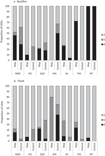
The overall means for the provision of mapping and development control () are comprised of a complex distribution of performance among States/Territories, planning instruments and hazard types (). Half of the LGAs in WA had no provision of development controls for bushfire or flood, but all had mapped bushfire prone land and many had mapped flood prone land (). In the NT, all the LGAs had no provision of development controls or mapping of bushfire prone land, but the same LGAs did have provision of development controls and mapping of flood prone land (). Just under half of NSW LGAs had no provision for bushfire mapping but only 30% had no provision for bushfire development controls (). However, performance in the provisions for flood mapping and development control was better (). Similar trends emerged in TAS and SA, with thorough provision of development controls for bushfire and flood, but gaps in the provision of bushfire and flood mapping in some LGAs (). Thorough provision of mapping development controls for bushfire and flood is also characteristic of VIC and QLD, although there are gaps in the provision of mapping and development controls particularly for some LGAs in QLD (). The geographic and organisational factors that might be influencing the provision of planning policy across States and Territories is explored in the next section.
Figure 1. Distribution of local-level (a) bushfire and (b) flood hazard mapping (map) and development control (control) scores across Australian States and Territories. Values show the proportion of LGAs in each state coded as 0 (no provision), 1 (partial provision) or 2 (thorough provision) for the relevant item. Items are explained in . The ACT was not assessed because it only consists of one LGA.
4.2. Geographic and Organisational Influences
The provision of planning policy was influenced by geographic and organisational factors. Larger land area LGAs generally had lower planning policy scores. When the LGAs were divided into quintiles by land area (111 LGAs per quintile), the largest land area quintile had an average planning policy score of 9.9. Only 16 of the 111 largest land area LGAs had good planning policy scores. In contrast, the two smallest land area quintiles had average planning policy scores of 11.3 and 12.07. This suggests that small land area LGAs are associated with strong planning provision for hazards, while large land area LGAs experience greater challenges in planning provision for hazards.
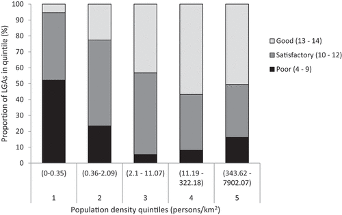
Similar relationships were shown for population density, with lower population density LGAs generally associated with lower planning policy scores (). The average planning policy score for the lowest population density quintile was 9.36, with only five LGAs in that quintile achieving a good planning policy score (). In contrast, the two quintiles of highest population density LGAs had an average planning policy score of more than 12 and over 50% of LGAs in these quintiles had good planning policy scores (). This further supports the finding about the relationship between land area and planning policy scores, because larger land area LGAs also have lower population density. Thus, large land area, low population density LGAs face greater challenges in sustaining robust planning policy for hazards.
Figure 2. Planning policy score distribution among population density quintiles.
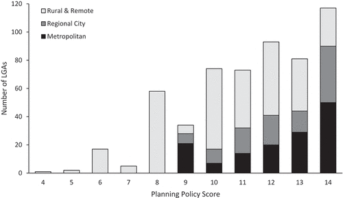
While remoteness drives poor planning policy scores for some rural and remote LGAs, planning policy scores in other LGAs are not directly related to remoteness. The 83 LGAs in Australia with a planning policy score of eight or less were rural and remote (). A further six rural and remote LGAs had a planning policy score of nine (). However, many rural and remote LGAs had satisfactory or good planning policy scores (). Regional city and metropolitan LGAs had a range of poor, satisfactory or good planning policy scores (). Thus, while remoteness drives poor planning policy scores for some rural and remote LGAs, planning policy scores in other LGAs are not directly related to remoteness.
Figure 3. Distribution of planning policy scores among metropolitan, regional city and rural/remote classes of LGAs. Remoteness classes are described in .
Remoteness, population density and land area interact to influence the prevalence of poor planning policy scores. The LGAs with a poor planning policy score (<10) had an average land area of 28,844 km2 (SD = 58,455 km2) and an average population density of 323 persons per km2 (SD = 495 persons per km2). In contrast, the LGAs with satisfactory or good planning policy scores had a lower average land area of 7,919 km2 (SD = 24,288 km2) and a higher average population density of 798 persons per km2 (SD = 1,204 persons per km2). The LGAs with a poor planning policy score were mostly located in the larger land area States and Territories: WA, QLD, the NT, SA and NSW, while LGAs in the smaller land area States and Territories of VIC, TAS and the ACT all had satisfactory to good planning policy scores (). Notably, 100% of all LGAs in the NT and 45% of all LGAs in WA have poor planning policy scores (). This implies that the numerous large area, small population, rural and remote LGAs in the NT and WA creates barriers to the provision of planning policy for natural hazards.
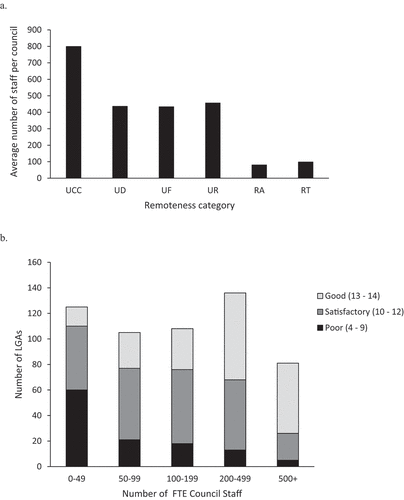
These geographic challenges to policy development can be further explored by comparing the relative size of local councils within different remoteness classes. A large local council is likely to have greater capacity for policy development, in part because the council’s operations will include a strategic planning department. Large councils are synonymous with populous LGAs and the majority are in metropolitan areas ()). Regional city councils also have moderate staff numbers ()). In contrast, rural and remote councils have much smaller staff numbers ()). Poor planning policy scores were often associated with LGAs with very small councils with <50 staff ()). However, some small councils also have satisfactory to good planning policy scores ()). In general, increasing council size was associated with higher planning policy scores ()). Data from the NSW Office of Local Government suggests that a local council of 100 staff will have two development control planners at most and some very small local councils, generally in rural and remote locations, might have no planning staff at all. The chances of finding specialised strategic planners employed in small rural and remote councils will therefore be very limited and is a likely influence on the provision of planning policy for natural hazards.
Figure 4. Council staffing and planning policy scores. (a) Average council FTE staff per remoteness class. (b) Planning policy score distribution among staffing levels. Remoteness classes are explained in . Brisbane was excluded from the UCC class, as the LGA covers much of the Brisbane metropolitan area, and is an outlier with >7000 FTE staff.
5. Discussion
Contemporary DRR and resilience strategy promotes local action supported by intergovernmental cooperation (UNDRR, Citation2015; COAG, Citation2011). In Australian land use planning, the main cooperative partnership is between state and local government, although a federalist influence has occasionally been felt (Williams, Citation2012). But while strategic intent grows at the top tiers of government, researchers continue to argue that improved local planning capacity is crucial for land use planning to effectively contribute to DRR and resilience outcomes (King, Citation2008; Torabi et al., Citation2017). This study revealed substantial variation in the capacity of Australian local governments to plan for hazards, measured through the planning policy score. Geographic and organisational factors influence hazard planning capacity, including differences between metropolitan and rural or remote council contexts, the land area of LGAs and the staffing of local councils. Intergovernmental cooperation for DRR and resilience must address local government capacity for hazards planning (UNDRR, Citation2015), and to do so in Australia requires infrastructure, land use and development planning practices that are integrated, strategic and adaptive to avoid creating new disaster risk (Australian Government, Citation2018). This research has contributed to that process by identifying the distribution of the capacity for policy development and implementation across Australia.
Land area, population density and council staffing levels influenced planning policy scores. In general, LGAs with large councils, typically in urban areas, were associated with higher planning policy scores, while LGAs with higher land areas and lower population densities, typically in rural and remote areas, were associated with lower planning policy scores. The urban-rural difference in planning policy provision has implications for the aspirational contributions of local land use planning to DRR and resilience. Well-staffed local governments have greater capacity for ongoing policy work to ensure planning provisions for natural hazards are complete and contemporary (Lyles et al., Citation2014). These local governments can maintain strategic planning departments for the continuous improvement of local planning policy. Smaller, under-staffed local governments, by contrast, are unlikely to maintain a strategic planning division, which potentially results in less continuous refinement of local planning provisions (Horney et al., Citation2017). The mix of capacity observed in this study creates a potential contradiction between national-level disaster risk reduction aspirations and the devolution of those aspirations to local governments without the resources to achieve them.
Strategies to equalise the capacity of local governments to contribute to DRR and resilience in Australia will need to be cognizant of the influence of geographical compactness on hazards planning. States and Territories with a relatively small land area, a large share of populous urban LGAs and no remote LGAs, generate more ideal conditions for consistency of policy provision such as a higher proportion of well-resourced local councils, and better opportunities for cooperation between local and state planning bodies. In Australia, these conditions are most likely to exist in VIC and the ACT and, to a lesser extent, TAS. By contrast, States and Territories with larger land areas and higher numbers of rural and remote LGAs can find that geographic factors like low population density, small council organisations, and remoteness will impede policy consistency. In Australia, these conditions are most likely to apply in WA, the NT, QLD, SA and NSW. The history of State politics in Australia suggests that governance arrangements and funding mechanisms for differential State size and degrees of remoteness can assist in equalising the capacity of local governments for hazards planning (Vardon, Citation2007). However, notions of efficiency are often applied to rationalise local government structural settings, leading to amalgamations or policy standardisations that in hindsight have proven unpopular with local communities (Farid Uddin, Citation2018), reduced council independence (Costar & Economou, Citation1999) or were detrimental to service delivery capacity, including in planning (Boyle, Citation2001; Drew et al., Citation2013; McQuestin et al., Citation2017). Addressing the varied geography of council capacity for planning policy provision should focus on strengthening local council factors such as internal resources, professional planning skills and balancing compliance with State mandates with appropriate emphasis on localised, place-oriented activities such as community engagement, risk identification and plan-making (Frazier et al., Citation2013; Berke et al., Citation2014).
The planning policy score was greatly influenced by bushfire and flood land mapping and development controls. Some LGAs had good provision for both hazard types, some focused on one hazard only, and some did not address either hazard type through land mapping or development control. Inconsistency in planning for bushfire and flood hazards at a local level may be related to local government capacity in several ways. First, under-resourced local councils may need to prioritise resources onto certain hazard types, after consideration of exposure and risk. Second, the provisions for hazard planning in state legislation and regional plans frame the requirements that councils with different capacities may, or may not, be able to address. Australia faces losses from natural disasters that are predicted to average 33 USD billion per annum by 2050 (Deloitte Access Economics, Citation2016). The Royal Commission into National Natural Disaster Arrangements recognised the increasing impacts of natural disaster in Australia and made recommendations for mandatory consideration of natural disaster risk in land-use planning decisions, better availability of natural hazard risk information and increased resourcing of local government to undertake disaster planning and management (Commonwealth of Australia, Citation2020). Implementation of these recommendations may assist to even out the inconsistencies in bushfire and flood hazard planning provisions observed in this study.
Much global and national strategy for DRR and resilience devolves great responsibility to the local level, often without mention of the affiliated funding commitments and governance arrangements that will be required to achieve desired local-level outcomes. One of the guiding clauses in the Sendai Framework is to ‘empower local authorities and local communities to reduce disaster risk, including through resources, incentives and decision-making responsibilities, as appropriate’ (UNDRR, Citation2015, p. 13). Australia’s NDRRF sets a national priority for informed and accountable risk-based decision making (Australian Government, Citation2018, p. 15). A five-year outcome from the strategy is that ‘integrated and robust frameworks are used to assess and reduce disaster risk in all environments, but particularly infrastructure, land use and development planning’ (Australian Government, Citation2018, p. 15). LGAs are closely linked to all these functions but the strategy does not mention the concomitant funding or governance arrangements needed at local levels to meet national targets. The evaluation of local government capacity for hazard planning in Australia suggests that realising national level DRR and resilience targets will be difficult or near impossible for many local councils and that the implementation of national level DRR strategy will never be uniform across Australia. The potential for local councils to contribute to DRR and resilience through land use planning is likely to remain unequal without substantial inputs of resources, skills and programs to support global and national aspirations. This requires more than blanket directives from a central authority. It requires an embedded governance system for identifying the trends driving policy inconsistency and supporting local authorities to address those policy inconsistencies.
Cutter et al. (Citation2014, p. 66) have argued that ‘composite quantitative measures are needed that would permit examination and/or comparison among places as to their present levels of both social vulnerability and disaster resilience, pointing decision-makers to possible targets for intervention and improvement’. If whole-of-government coordination of disaster risk reduction and resilience entails the effective support of local government capacity, comparative capacity for local governments to plan for hazards is a desirable indicator in indexes of disaster resilience or vulnerability (e.g. Cutter et al., Citation2008; Parsons et al., Citation2016). A resilience index can point to specific factors that influence the resilience of an area. A resilience index can also identify resilience within a wider regional context, so ‘mitigation efforts can be targeted at the most vulnerable groups or counties’ (Cutter et al., Citation2003, p. 258). The comparative national-scale assessment of the relative capacity of local governments to plan for hazards can be incorporated into index computation as part of a suite of disaster resilience factors (e.g. Parsons et al., Citation2016). Exploring how areas perform on land use planning for hazards relative to other aspects of disaster resilience can highlight the contributions of, but also the barriers to, effective land use planning to achieve DRR and resilience aspirations.
Several limitations may have influenced the formation and evaluation of the policy planning score. Information collection was restricted to explicit statements of planning policy in state, regional and local contexts to evaluate the hazard planning potential of 555 LGAs in Australia, using legislation and provisions current in 2015–2017, and in relation to flood and bushfire hazards only (Baer, Citation1997; Berke & Godschalk, Citation2009). Results might have varied if resources were available to increase the variety of hazards considered, or to broaden the inclusions in the analysis of policy, such as: frequency of policy review; local resources for planning compliance; plan format and implementation processes; and, quality of policy communication (Baer, Citation1997). Alternative methods of data collection (e.g. key informant interviews) were not viable given the national-scale scope of the study (Frazier et al., Citation2013; Horney et al., Citation2017). The coding protocol also relied entirely on maps and policies available online: it is possible that some councils hold relevant material that is not publically available or not published digitally (e.g. some hazard risk maps). Nonetheless, the study has undertaken, for the first time, a national-scale comparative assessment of the capacity of local governments to plan for hazards, embedded in well-established principles of indicator development and plan evaluation (Berke & Godschalk, Citation2009). It is unlikely that a more detailed analysis protocol would greatly alter the overall pattern of planning policy scores observed in the study. Minor changes to the protocol might cause a few LGAs to move from the satisfactory to good class, but it would be unlikely that this would alter the observed broad pattern of poor, satisfactory and good planning policy scores, or its relationship to geographic or organisational factors.
6. Conclusions
Global and national strategy situates land use planning as a central mechanism of DRR and resilience. Growing recognition of the effects of climate change on the frequency and magnitude of some types of natural hazard events (Climate Council, Citation2019) has increased the prominence of land use planning as a DRR solution. Aligned to these strategies is an assumption of cooperation among sectors, where ‘all sectors have shared but defined responsibilities to reduce disaster risk’ (Australian Government, Citation2018, p. 8). However, broad strategic statements about the localisation of DRR within a shared responsibility model often fail to acknowledge the complex governance, capacity and geographic factors that may form barriers to the local improvement of DRR through land use planning. Indeed, the historical interplay of national, state and local governments in Australia is not always one of cooperation (Dollery et al., Citation2012). The competencies, governance arrangements and responsibilities of cooperative partners in relation to disaster planning and management also remain unclear in practice (Howes et al., Citation2014; McLennan & Handmer, Citation2012; de Lourdes Melo Zurita et al., Citation2015). The success of land use planning as a DRR solution in Australia will be influenced not only by the degree to which cooperation can be achieved, but by the capacity and willingness of local councils to work within a subsidiary system of strategic intent. This paper has shown that there is currently great differentiation in the capacity of local Australian councils in hazards planning provision, making it unlikely that future strategic intent for land use planning as a DRR mechanism will be successful in many places without first addressing the fundamentals of place-based council capacity, planning skills and governance arrangements. Commensurately, other places should be well-positioned to participate in, and potentially lead, the cooperative uptake of land use as a DRR solution. For DRR and resilience outcomes in the public interest, stakeholders need to understand the occurrence of both positions. The findings from this Australian study have implications for any country with aspirations for land use planning to address and reduce disaster risk. The capacity of local planning agencies to plan for hazards, and the policy, geographic and resource factors that may constrain that capacity, should be considered when designing high-level strategy. Without this consideration, strategies may fail to achieve disaster risk reduction through land use planning and development control mechanisms, and in a worst case scenario, could unknowingly increase disaster risk unless appropriate capacity building and resourcing accompanies aspirational targets.
Acknowledgements
The authors thank Kelly Wang and Sahar Alian for research assistance.
Disclosure Statement
No potential conflict of interest was reported by the author(s).
Additional information
Funding
References
- Australian Bureau of Statistics (ABS). (2016) Regional Population Growth Australia, Data Spreadsheet 3218.0 (Canberra: Australian Bureau of Statistics).
- Australian Government. (2018) National Disaster Risk Reduction Framework (Canberra: Department of Home Affairs).
- Australian Institute for Disaster Resilience (AIDR). (2020) Land Use Planning for Disaster Resilient Communities (Melbourne: AIDR).
- Baer, W. C. (1997) General plan evaluation criteria: An approach to making better plans, Journal of the American Planning Association, 63(3), pp. 329–344. doi:10.1080/01944369708975926.
- Barnett, J., Lambert, S., & Fry, I. (2008) The hazards of indicators: Insights from the environmental vulnerability index, Annals of the Association of American Geographers, 98(1), pp. 102–119. doi:10.1080/00045600701734315.
- Berke, P., Cooper, J., Aminto, M., Grabich, J., & Horney, J. (2014) Adaptive capacity for disaster recovery and resiliency: An evaluation of 87 local recovery plans in eight states, Journal of the American Planning Association, 80(4), pp. 310–323. doi:10.1080/01944363.2014.976585.
- Berke, P., & Godschalk, D. (2009) Searching for the good plan: A meta-analysis of plan quality studies, Journal of Planning Literature, 29(3), pp. 227–240. doi:10.1177/0885412208327014.
- Berke, P. R., Crawford, J., Dixon, J., & Ericksen, N. (1999) Do cooperative environmental planning mandates produce good plans? Empirical results from the New Zealand experience, Environment and Planning B: Planning and Design, 26(5), pp. 643–664. doi:10.1068/b260643.
- Boyle, R. (2001) Amalgamation of local councils in Victoria: Its impact on the employment of town planners, Urban Policy and Research, 19(3), pp. 376–378. doi:10.1080/08111140108727886.
- Carayannopolous, G. (2017) Disaster Management in Australia: Government Coordination in a Time of Crisis (London: Routledge).
- Climate Council. (2019) Weather Gone Wild: Climate-change Fuelled Extreme Weather in 2018 (Sydney: Climate Council).
- Commonwealth of Australia. (2020) Royal Commission into National Natural Disaster Arrangements Report (Canberra: Royal Commission into National Natural Disaster Arrangements).
- Costar, B., & Economou, N. (1999) The Kennett Revolution: Victorian Politics in the 1990s (Sydney: UNSW Press).
- Council of Australian Governments (COAG). (2009) Communique: COAG Meeting, Brisbane, 7 December 2009. www.coag.gov.au/meeting-outcomes (accessed 14 January 2019).
- Council of Australian Governments (COAG). (2011) National Strategy for Disaster Resilience (Canberra: Australian Government).
- Cutter, S. L., Ash, K. T., & Emrich, C. (2014) The geographies of community disaster resilience, Global Environmental Change, 29, pp. 65–77. doi:10.1016/j.gloenvcha.2014.08.005.
- Cutter, S. L., Barnes, L., Berry, M., Burton, C., Evans, E., Tate, E., & Webb, J. (2008) A place-based model for understanding community resilience to natural disasters, Global Environmental Change, 18(4), pp. 598–606. doi:10.1016/j.gloenvcha.2008.07.013.
- Cutter, S. L., Boruff, B. J., & Lynn, S. W. (2003) Social vulnerability to environmental hazards, Social Science Quarterly, 84(2), pp. 242–261. doi:10.1111/1540-6237.8402002.
- de Lourdes Melo Zurita, M., Cook, B., Harms, L., & March, A. (2015) Towards new disaster governance: Subsidiarity as a critical tool, Environmental Policy and Governance, 25(6), pp. 386–398. doi:10.1002/eet.1681.
- Deloitte Access Economics. (2016) The Economic Cost of the Social Impact of Disasters (Sydney: Australian Business Roundtable for Disaster Resilience and Safer Communities).
- Department of Infrastructure, Planning and Natural Resources NSW (DIPNR). (2005) Floodplain Development Manual (Sydney: New South Wales Government).
- Deyle, R. E., & Smith, R. A. (1998) Local government compliance with state planning mandates: The effects of state implementation in Florida, Journal of the American Planning Association, 64(4), pp. 457–469. doi:10.1080/01944369808976004.
- Dollery, B. E., Grant, B., & Kortt, M. (2012) Councils in Cooperation: Shared Services and Australian Local Government (Sydney: Federation Press).
- Drew, J., Court, M. A., & Dollery, B. (2013) A cautionary tale: Council amalgamation in Tasmania and the Deloitte Access Economics report, Australian Journal of Public Administration, 72(1), pp. 55–65. doi:10.1111/1467-8500.12011.
- Eccles, D., & Bryant, T. L. (1999) Statutory Planning in Victoria (Sydney: The Federation Press).
- Emergency Management Australia (EMA). (2002) Planning Safer Communities: Land Use Planning for Natural Hazards (Canberra: Australian Government).
- Farid Uddin, K. (2018) NSW local government reform: Council amalgamation, antagonism, and resistance, Journal of Public Affairs, 18(4), pp. e1725. doi:10.1002/pa.1725.
- Federal Emergency Management Agency (FEMA). (2013) Integrating Hazard Mitigation into Local Planning: Case Studies and Tools for Community Officials (Washington DC: FEMA).
- Frazier, T. G., Walker, M. H., Kumari, A., & Thompson, C. M. (2013) Opportunities and constraints for hazard mitigation planning, Applied Geography, 40, pp. 52–60. doi:10.1016/j.apgeog.2013.01.008.
- Godschalk, D. R. (2003) Urban hazard mitigation: Creating resilient cities, Natural Hazards Review, 4(3), pp. 136–143. doi:10.1061/(ASCE)1527-6988(2003)4:3(136).
- Godschalk, D. R. (2010) Integrating hazards into the implementation tools of planning, in: J. C. Schwab (Ed) Hazard Mitigation: Integrating Best Practices into Planning, pp. 47–58 (Chicago: American Planning Association).
- Gurran, N. (2007) Australian Urban Land Use Planning: Introducing Statutory Planning Practice in New South Wales (Sydney: Sydney University Press).
- Hoppe, T., van Den Berg, M. M., & Coenen, F. H. J. M. (2014) Reflections on the uptake of climate change policies by local governments: Facing the challenges of mitigation and adaptation, Energy, Sustainability and Society, 4, pp. Article 8. doi:10.1186/2192-0567-4-8.
- Horney, J., Nguyen, M., Salvesen, D., Dwyer, C., Cooper, J., & Berke, P. (2017) Assessing the quality of rural hazard mitigation plans in the Southeastern United States, Journal of Planning Education and Research, 37(1), pp. 56–65. doi:10.1177/0739456X16628605.
- Howes, M., Tangney, P., Reis, K., Grant-Smith, D., Heazle, M., Bosomworth, K., & Burton, P. (2014) Towards networked governance: Improving interagency communication and collaboration for disaster risk management and climate change adaptation in Australia, Journal of Environmental Planning and Management, 58(5), pp. 757–776. doi:10.1080/09640568.2014.891974.
- International Decade for Natural Disaster Reduction (IDNDR). (1994) Yokohama Strategy and Plan of Action for a Safer World (Geneva: United Nations Department of Humanitarian Affairs).
- King, D. (2006) Planning for hazard resilient communities, in: D. Paton & D. Johnston (Eds) Disaster Resilience: An Integrated Approach, pp. 288–304 (Springfield: Charles T. Thomas).
- King, D. (2008) Reducing hazard vulnerability through local government engagement and action, Natural Hazards, 47(3), pp. 497–508. doi:10.1007/s11069-008-9235-5.
- Kornakova, M., March, A., & Gleeson, B. (2017) Institutional adjustments and strategic planning action: The case of Victorian wildfire planning, Planning Practice and Research, 33(2), pp. 120–136. doi:10.1080/02697459.2017.1358505.
- Lebel, L., Anderies, J. M., Campbell, B., Folke, C., Hatfield-Dodds, S., Hughes, T. P., & Wilson, J. (2006) Governance and the capacity to manage resilience in regional social-ecological systems, Ecology and Society, 11(1), pp. Article 19. doi:10.5751/ES-01606-110119.
- Lyles, L. W., Berke, P., & Smith, G. (2014) Do planners matter? Examining factors driving incorporation of land use approaches into hazard mitigation plans, Journal of Environmental Planning and Management, 57(5), pp. 792–811. doi:10.1080/09640568.2013.768973.
- March, A., & Dovers, S. (2017) Mainstreaming urban planning for disaster risk reduction: Five capabilities for Australian urban planning, in: N. Sipe & K. Vella (Eds) The Routledge Handbook of Australian Urban and Regional Planning, pp. 231–246 (New York: Routledge).
- McLennan, B. J., & Handmer, J. (2012) Reframing responsibility-sharing for bushfire risk management in Australia after Black Saturday, Environmental Hazards, 11(1), pp. 1–15. doi:10.1080/17477891.2011.608835.
- McQuestin, D., Drew, J., & Dollery, B. (2017) Do municipal mergers improve technical efficiency? An empirical analysis of the 2008 Queensland municipal merger program, Australian Journal of Public Administration, 77(3), pp. 442–455. doi:10.1111/1467-8500.12286.
- New Zealand Government. (2019) National Disaster Resilience Strategy (Wellington: Ministry of Civil Defence and Emergency Management).
- NSW Government. (2020) Environmental Planning and Assessment Act 1979 (Sydney: NSW Government).
- Parsons, M., Glavac, S., Hastings, P., Marshall, G., McGregor, J., McNeill, J., Morley, P., Reeve, I., & Stayner, R. (2016) Top-down assessment of disaster resilience: A conceptual framework using coping and adaptive capacities, International Journal of Disaster Risk Reduction, 19, pp. 1–11. doi:10.1016/j.ijdrr.2016.07.005.
- Planning Institute of Australia (PIA). (2018) National Land Use Planning Guidelines for Disaster Resilient Communities (Canberra: PIA).
- Queensland Reconstruction Authority (QRA). (2012) Planning for Stronger, More Resilient Floodplains. Part 1 – Interim Measures to Support Floodplain Management in Existing Planning Schemes (Brisbane: QRA).
- State of Queensland. (2016) Queensland Local Government Grants Commission: Annual Report 2015 (Brisbane: Department of Infrastructure, Local Government and Planning).
- Stevens, M. R., Lyles, W., & Berke, P. R. (2014) Measuring and reporting intercoder reliability in plan quality evaluation research, Journal of Planning Education and Research, 34(1), pp. 77–93. doi:10.1177/0739456X13513614.
- Torabi, E., Dedekorkut-Howes, A., & Howes, M. (2017) Not waving, drowning: Can local government policies on climate change adaptation and disaster resilience make a difference? Urban Policy and Research, 35(3), pp. 312–332. doi:10.1080/08111146.2017.1294538.
- United Nations International Strategy for Disaster Reduction (UNISDR). (2005) Hyogo Framework for Action, 2005–2015: Building the Resilience of Nations and Communities to Disaster (Geneva: UNISDR).
- United Nations Office for Disaster Risk Reduction (UNDRR). (2015) Sendai Framework for Disaster Risk Reduction, 2015–2030 (Geneva: UNDRR).
- van Den Berg, M. M., & Coenen, F. (2012) Integrating climate change adaptation into Dutch local policy and the role of contextual factors, Local Environment, 17(4), pp. 441–460. doi:10.1080/13549839.2012.678313.
- Vardon, S. (2007) Does size really matter? Australian Journal of Public Administration, 66(3), pp. 261–274. doi:10.1111/j.1467-8500.2007.00540.x.
- Williams, P. (2012) Statutory planning, in: S. Thompson & P. J. Maginn (Eds) Planning Australia: An Overview of Urban and Regional Planning, pp. 98–118 (Port Melbourne: Cambridge).