
ABSTRACT
This paper analyses challenges and enablers for integrating a transboundary land-sea interaction (LSI) perspective into marine spatial planning (MSP) practice as experienced in the Baltic Sea Region. Collaborative research results from the Pan Baltic Scope project indicate that LSI remains an amorphous concept, particularly within a transboundary MSP context. Difficulty lies in bridging planning practices across land and sea and between varying uses, administrative settings and governance functions. Addressing LSI requires capacity, time, resources, awareness, reflection, and forums for collaborative learning across sectors and governance levels.
1. Introduction
‘We have always taken land-sea interaction [LSI] issues into account. If we consider this a basic planning principle, there is no need to think about it too much.’ (Survey respondent, 2018 from area with coastal planning).
‘We currently have not solved the LSI discussion [.] it is a part of the archipelago day-to-day life, and we cannot separate it out as a concrete [planning] question …’ (Project Partner, 2019 from archipelago area without coastal planning).
Marine spatial planning (MSP) and integrated coastal zone management (ICZM) are important mechanisms for promoting the long-term sustainable use of marine and coastal areas globally (Jay, Citation2018). In the late 1990s and early 2000s, the European Union (EU) advocated ICZM as an integrative approach for connecting the land-sea interface (European Parliament and Council, Citation2002). More recently, the EU’s 2014 MSP Directive (European Parliament and Council, Citation2014), has promoted transboundary MSP as a tool for integration, aiming to enhance alignment, coherence and coordination in the management of shared European sea spaceFootnote1 The MSP Directive also calls upon Member States to take account of land-sea interactions (LSI),Footnote2 leading European marine planners to duly examine LSI and the cross-border connections that link the planning of marine areas to planning onshore (Jones & Kidd, Citation2017). It is widely acknowledged that effective problem solving across the land-sea boundary, and the sustainable management of coastal and marine social-ecological systems, requires terrestrial and marine spatial planning to be linked.
Developing a transboundary MSP perspective that includes land-sea interactions is challenging due to issues of sovereignty, multi-level governance, institutional mandates and responsibilities, heterogenous planning practices, and gaps with respect to knowledge, methods, capacity and skills (Kerr et al., Citation2014). Countries new to MSP have to develop entirely new institutions and channels of communication, collaboration and capacity building; they also need to integrate existing sector-based institutions and governance levels (for the Baltic Sea, see e.g. Morf et al., Citation2019b; Ministry of Environmental Protection and Regional Development of the Republic of Latvia (MoEPRD Latvia), Citation2019a, Citation2019b). At present, MSP systems are evolving fast, and existing planning cultures appear to vary considerably between land and sea, as well as across administrative levels and borders (Smith et al., Citation2011; Kidd & Shaw, Citation2014; Nadin et al., Citation2018).
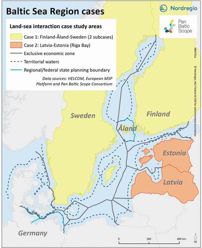
The Pan Baltic Scope project (2018–2019), co-financed by the European Maritime and Fisheries Fund (EMFF) and project partners, brought together national and regional planning authorities around the Baltic Sea (Denmark, Germany, Poland, Latvia, Estonia, Finland, Åland and Sweden) to identify challenges and find solutions to common transboundary MSP problems. A core aim of the project has been to collaboratively define and enhance understanding of LSI by identifying the key drivers, challenges and enablers of LSI within a transboundary MSP context (Morf et al., Citation2019b). New knowledge of transboundary LSI processes was developed by planners and researchers in two practical cases, one in the Gulf of Bothnia and the other in Riga Bay.Footnote3 The project covered a range of countries with different types of LSI practices, transboundary problems, geographical scales and varying stages of MSP development ().
Figure 1. Pan Baltic scope land-sea interaction case study areas with two practical cases in the Gulf of Bothnia (Case 1) and Riga Bay (Case 2). Source: Nordregio and Morf et al. (Citation2019b).
Focusing on the Baltic Sea Region (BSR) and especially on the two practical cases, this paper explores and discusses key challenges and enablers for transboundary integration across the land-sea interface as experienced by countries still establishing their MSP systems. The paper addresses the following specific questions:
Which challenges and enablers are experienced by Baltic Sea countries when integrating planning across the land-sea boundary in a cross-border context?
Which insights and recommendations of wider relevance can be formulated for overcoming existing barriers to LSI in MSP?
Based on Oxford English Dictionary definitions, challenges here refer to processes, tools, methods and stakeholders that inhibit transboundary integration across the land-sea interface in MSP, while enablers are understood as similar factors facilitating such integration (see e.g. UNEP, Citation2017). The analysis presented here is based on key findings from the Pan Baltic Scope case studies, which used a collaborative and reflective multi-method design, including literature analysis, surveys, collaborative mapping and writing, and participant observation.
The first section of the paper provides an introduction to the topic, followed by an overview of LSI literature. The third section outlines the project approach, including a description of the case study areas, the methods applied and the analytical framework that was used to assess key challenges and enablers for LSI in the BSR. The fourth section extracts the main findings from the two practical cases. The fifth section presents challenges and enablers of broader relevance while the conclusions reflect on ways forward, including recommendations to overcome LSI barriers.
2. Policy and Research Perspectives on LSI
The relationship between MSP and terrestrial planning is increasingly relevant, particularly the need to make ecological, economic, and social connections between land and sea (Kerr et al., Citation2014). Kidd et al. (Citation2020, p. 3) describe LSI as involving ‘intricate and constantly shifting interconnections between socio-economic activities both in the sea and on land, with natural processes that span the land-sea interface’. They continue that ‘the experience in both these dimensions is also influenced directly and indirectly by governance arrangements related to marine and terrestrial areas’.
LSI as a concept is not new (Morf et al., Citation2019a); indeed, LSI has long been a central component of ICZM, reflected in a large body of academic literature (e.g. Beger et al., Citation2010; Smith et al., Citation2011; Portman et al., Citation2012; Granit et al., Citation2014). Recently however, policymakers and academics have become more interested in the interrelationship between LSI and MSP, particularly within a transboundary context (see e.g. Ramieri et al., Citation2018; Shipman et al., Citation2018; Nadin et al., Citation2018). The LSI concept has gained significance due to Article 4 of the EU Directive on Maritime Spatial Planning (2014/89/EU),Footnote4 which states that when establishing and implementing MSP ‘Member States shall take into account land-sea interactions’, based on the understanding that marine and coastal activities are closely interrelated and that considering LSI in MSP is ‘important for promoting sustainable use of maritime space’ (ibid., preamble (10)). Indeed, activities occurring on land and sea are interrelated and need cohesive planning perspectives, such as ports infrastructure to facilitate the development of marine renewables or protecting marine ecosystems and water quality. However, the EU Directive does not provide any clear guidance on how countries should take LSI into account, so operationalising Article 4 remains difficult. LSI is also considered an important element of the EU’s Marine Strategy Framework Directive (MSFD), Water Framework Directive (WFD) implementation (e.g. Kidd & Shaw Citation2007), Marine Protected Area (MPA) management and conservation planning, with their own extensive bodies of literature (see e.g. Skovgaard Kirkfeldt & Harbo Andersen, Citation2021 as one recent example).
Scholars suggest that MSP and terrestrial planning tend to be conducted separately within different epistemic communities (Walsh & Kannen, Citation2019). Responsibility for terrestrial and marine planning often lies with different administrative units and governance levels, with the separation of mandates rooted in the history of national or local planning traditions (Drankier, Citation2012; Kidd et al., Citation2019). Coordinating and integrating planning between land and sea is known to be a challenge due to complex constellations of actors and agency and competing sectoral uses. There is also uncertainty about institutional responsibilities and at what scale these are applied (Jones & Kidd, Citation2017). Water resource management research recognises that establishing parallel systems is likely to increase redundancy and institutional complexity and keep apart issues that would need linking (Kidd & Shaw, Citation2007).
Marine and coastal planning research on LSI, ICZM and spatial governance has examined the relationship between different planning concepts (e.g. Kerr et al., Citation2014; Retzlaff & LeBleu, Citation2018; Kidd et al., Citation2019; Morf et al., Citation2019b; Walsh & Kannen, Citation2019). Kidd and Ellis (Citation2012), Kidd et al. (Citation2019), Kerr et al. (Citation2014) and Jay (Citation2018) emphasise the need for reflexive thinking about MSP by exploring epistemological, conceptual and normative similarities and differences between marine and terrestrial planning. Kerr et al. (Citation2014) analysed the origin of marine and terrestrial spatial planning and their inherent differences in response to different kinds of governance setups, needs, mandates and resources, recognising a growing need for coordination. While the social science community in spatial planning has generally had limited engagement with the evolution of the MSP discourse (Kidd & Ellis, Citation2012; Walsh & Kannen, Citation2019), there is growing interest in examining MSP alongside land planning debates (Kidd & Shaw, Citation2014; Jay, Citation2018; Nadin et al., Citation2018).
Based on the current state of knowledge and ongoing academic LSI discussions, three questions need clarification to further develop the concept of LSI. First, what is the focus of LSI and the different interactions it describes? Second, what geographical range should LSI encompass? And, third, what are the key challenges and enablers for implementing LSI in practice?
Two recent projects have contributed to the conceptual development of LSI and its translation into planning practice. BONUS BALTSPACE (2015–18) investigated LSI as a part of an exploration of integration in MSP. A four-dimensional analytical framework – encompassing sector and policy, transboundary, stakeholder, and knowledge integration – was developed to study integration in five case studies in the BSR (Saunders et al., Citation2016). Within the project, a spatial cost-benefit analysis was developed and applied to shipping and offshore wind in Germany, highlighting the dispersed nature of LSI by showing that onshore economic benefits from these sectors can reach hundreds of kilometres beyond the sea (Weig & Schultz-Zehden, Citation2018).
The 2019 ESPON project MSP-LSI, worked with conceptual clarification and governance analyses, concurrently with Pan Baltic Scope, identifying concrete value chains across the land-sea interface. LSI was unpacked into a framework covering four main elements (environmental land-sea processes, human activities, related opportunities and risks), complemented by a suggestion to build on the Barcelona Convention and distinguish threefold between ‘LSI’ as the interactions in question,Footnote5 more openly defined ‘coastal areas’ and ‘LSI core areas’ based on marine planning boundaries (Kidd et al., Citation2020, p. 4 ff.). The project also found that governance arrangements, stakeholder collaboration, knowledge, and data availability play a key role in dealing with LSI opportunities and risks. A central conclusion from ESPON MSP-LSI is the need for a ‘one space view on territorial planning’ to address interconnectedness in planning and the interactions between land and sea (Kidd et al., Citation2020). The key findings suggest that there are integrating mechanisms within the existing legislation; however, practices are limited where responsibilities are distributed across planning bodies and where mechanisms to coordinate priorities and actions are lacking. The project recognises the importance of a place-sensitive approach, meaning there is no universal approach to identifying and managing LSI (Kidd et al., Citation2020).
Neither project attempted to address the concept of LSI practically in cross-border contexts, in the sense of working with planning actors with evolving planning systems around sea basins and exploring the application of LSI and associated opportunities and challenges, as was the point of departure of Pan Baltic Scope. The next section outlines the approach and focus of the project, including its analytical framework, case studies and research methods.
3. The Pan Baltic Scope Approach to Studying LSI
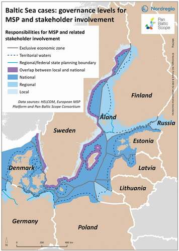
The Pan Baltic Scope project (2018–2019) was the second in a series of cross-border projects of mandated MSP authorities in the BSR to facilitate the implementation of the EU Framework Directive on MSP (2014/89/EU). Bringing together the responsible planning authorities (national, regional and sub-national), and supported by regional organisations (the Helsinki Commission, HELCOM, and Vision and Strategies around the Baltic, VASAB) and knowledge organisations (Nordregio and the Finnish Environment Institute), the project aimed to develop capacity for cross-border collaboration and coordination of marine plans. The work package Integrating Land-Sea Interactions into MSP sought to explore and operationalise the LSI concept. Work focused on two practical cases () in the Gulf of Bothnia (case 1) and Riga Bay (case 2), based on topics identified by the planners, such as establishing ‘connections between the national MSP process and planning activities of local governments’ and showing ‘how the national maritime spatial plan relates to the plans of the local municipalities’ (planners in project partner survey, 2018). Key differences in governance levels in MSP, affecting both LSI coordination, cross-border collaboration and stakeholder involvement, are illustrated in .
Figure 2. MSP governance levels in the Pan Baltic Scope project area. Source: Nordregio.
3.1. The Gulf of Bothnia Case
The Gulf of Bothnia case examined the sea, coasts and archipelago areas in the Gulf of Bothnia at two geographical scalesFootnote6:a) as a whole concentrating on identifying cross-border LSI issues that needed to be linked to MSP and developing a relevant network of planners and marine stakeholders across the Gulf, and b) the archipelago between the independent region of Åland and the Finnish Region of Satakunta. The latter was connected to the Finnish and Ålandic MSP processes, focusing on local stakeholder involvement, motivation and trust and thematically on energy, fisheries and aquaculture.
The case is characterised by the differing status of planning and institutional development in the respective countries. At the time of the project, the Swedish MSP process was almost complete, while MSP processes had only recently begun in Finland and Åland; there is also a diverse institutional framework for marine and coastal planning. Both factors affected work with LSI in general, as well as stakeholder involvement in the project (see and below).
In Finland, all three institutional tiers – national, regional and municipal – are involved in MSP. Responsibility for driving the process lies with the regional level. Eight Regional Councils (statutory joint municipal authorities) are responsible for both regional land use planning (which covers territorial waters) and for drafting and approving the Marine Spatial Plans (which cover territorial waters and the EEZ). MSP in Finland, therefore, overlaps with regional (extending into territorial waters) and municipal planning (extending into onshore waters). The Ministry of Environment is responsible for MSP legislation, general development and international cooperation.
On Åland, at the time of the project, the municipalities were responsible for terrestrial planning, while the Government of Åland was to plan the territorial sea.Footnote7 Although the municipalities had no mandate to plan within the sea, they could plan uses and infrastructure on the shore, such as piers, marinas, docks, and beaches. According to the Ålandic Water Act, land-sea interactions need to be considered in MSP, requiring good coordination between government and municipalities.
In Sweden, the national MSP process is steered and coordinated by the Swedish Agency for Marine and Water Management. MSP plans are adopted by the Swedish Government. The national MSP mandate overlaps with that of local authorities for a stretch of 11 nautical miles: municipalities and some county councils are responsible for planning land and water use within their territory, which encompasses the territorial sea. County administrative boards are the key coordinators between national MSP and municipal coastal planning and specifically tasked with cross-level, cross sector and cross-municipal coordination. They also coordinate national funding dedicated to promoting municipal and regional coastal planning, which makes them key facilitators in establishing a land-sea planning continuum.
In the case, public workshops were held, with varying thematic foci and involving different authorities, sector experts, researchers and marine user representatives within aquaculture, fisheries and energy production. Digital surveys and participatory mapping tools were used to gauge stakeholder views and share information, most intensively in Åland and Satakunta. Case work resulted in mapping out and establishing contacts, the production of heat maps for different use interests, plus a story map (https://arcg.is/1mfmDD) that links LSI to cross-border collaboration. All results were used in on-going MSP and cross-border interaction processes. In Finland, the project informed and inspired regional strategies and development plans, but also an ‘LSI-landscape model’ that was used for stakeholder interaction.
3.2. The Riga Bay Case
Riga Bay is a large bay with predominantly sandy shores framed by islands in the North. The case study encompassed all Latvian and Estonian coastal municipalities in Riga Bay but concentrated on a pilot plan for the Latvian border municipality of Salacgrīva. One aim was to examine local authorities’ interests, needs and opportunities to plan across the land-sea boundary. Further aims were to assess the need for a stronger local planning mandate in the sea (Estonia) and to enhance coastal planning capacity in both countries. A wide range of topics were covered, including coastal recreation, nature protection, ports, pollution, real estate development, tourism, coastal erosion and offshore energy.
At the time of the project, Latvia was in the final stages of their national MSP process, while Estonian MSP was at the drafting stage, with two adopted pilot plans. Local authorities needed to be mobilised and enabled to plan. Like in the Gulf of Bothnia case, responsibilities, levels of authority and mandates for MSP and terrestrial planning differed between countries.
In Estonia, the Planning Act attributes the responsibility for MSP to the Estonian National Government, which has delegated it to the Ministry of Finance. In accordance with the Water Act, the national government has full jurisdiction over all marine areas and is responsible for managing natural resources, including territorial waters and the EEZ. Neither private individuals, nor local authorities, have any rights over sea areas. Whilst municipalities have a key role in planning for LSI, they lack a mandate for dealing with marine areas.
In Latvia, the national government is responsible for strategic planning in the entire state territory, including the sea. The state can set sector targets, for instance, for tourism, climate or transport. The state has also established and manages several MPAs. The Land Management LawFootnote8 recently mandated municipalities to extend their plans to a 2 km strip of coastal water, which overlaps with national MSP. The resulting need for cross-level coordination and capacity development became a focus of Pan Baltic Scope.
Case work included surveys and workshops with coastal municipalities, additional public meetings involving coastal stakeholders and residents for the pilot planning study in Salacgrīva, implying a spatial scale that was easier to identify with than national MSP. Concrete outputs included a coastal pilot plan for Salacgrīva and a guideline for municipal coastal planning (MoEPRD Latvia, Citation2019a, Citation2019b).
3.3. Analytical Framework
Given the lack of a common definition of LSI at the outset of the project and based on a literature review (Morf et al., Citation2019a), the project defined LSI in coastal and marine planning as encompassing ‘all natural and human-induced flows and processes between marine and terrestrial environments in both directions, as well as how these interactions are perceived and managed by societies and their different actors through MSP and other governance frameworks and processes (i.e. authorities, enterprises, users, NGOs and what they do about these interactions)’ (Morf et al., Citation2019a, p. 17). To enable systematic analysis and reflection, a multi-dimensional analytical framework was developed to examine LSI (Box 1). The four dimensions proposed focused on providing the necessary evidence base for LSI planning processes and the availability of methods and tools to collect and process different types of knowledge. These dimensions were complemented by two extra questions that connect the four dimensions and guide practical work.
Box 1. Analytical framework used for LSI work in Pan Baltic Scope.
Four analytical dimensions:
LSI issues (uses and interactions) to plan for: What are the key issues in each setting and possible associated geographic hotspots?
Institutional aspects: What governance structures (planning systems and administrative settings) exist to address the issues identified?
Process related aspects: How can the issues identified be conceived of as part of a planning process and who is affected and should be invited to participate?
Knowledge and methods-related aspects: What data, knowledge and method development is needed to address the above?
Complementary cross-cutting aspects:
What important contextual factors and trends affect the above?
Interrelationships, challenges and enablers: How do the above dimensions interconnect? What are related key challenges in practical work and what enablers can address them?
Source: Morf, et al. (Citation2019b), adapted.
3.4. Overall Process for Data Collection and Case Work
The focus for most partners in the two practical cases was on preparatory steps designed to promote a better grasp of LSI issues and associated institutional, process and knowledge-related aspects. In line with the questions in Box 1, case work concentrated on:
establishing cross-border topics and LSI issues to understand their potential relevance for cross-border planning;
identifying and linking the institutions relevant for tackling LSI topics;
creating the necessary contacts, networks and processes;
assembling and sharing existing knowledge and starting to fill in knowledge gaps;
pilot planning (Salacgriīva case) based on discussions with local authorities on how they could engage more in coastal planning (Riga Bay case) and feed into on-going MSP processes (Gulf of Bothnia);
identifying related LSI challenges and enablers and other concrete lessons learned; and
developing guidance documents and recommendations.
A mixed methods collaborative research approach was chosen to collect data across the cases (Heron, Citation1996; Yin, Citation2009). The data and sources used for cross-case analysis and synthesis included a) participant observation and notes from project workshops, work-package and overall project meetings, b) three digital surveys with project participants using Survey Monkey and c) written input from the case leaders using a word template based on the analytical framework to identify and structure LSI issues and sum up characteristics, challenges and enablers for specific cases at the end of the project. Verification occurred through internal and external project workshops (e.g. public project meetings, Baltic MSP Forum).
4. Case Specific LSI Findings – Gulf of Bothnia and Riga Bay
Using the analytical framework as a structure, we now present key lessons that emerged from across the two case studies. We first reflect on the institutional settings for the cases before presenting the challenges and enablers that were identified for working with LSI across borders.
both cases, partner institutions were at different stages of MSP development. While similar LSI issues were recognised by all partners, there were also differing needs and diverging interests in terms of working with LSI. Although the systems and traditions in the case studies emphasise lower governance levels, it emerged that key marine activities and issues are often missing in local level plans and strategies. They remain challenging to integrate as responsibility for them mostly lies with the national level (e.g. shipping, fisheries, environment, energy). A key aspect in a transboundary context is that responsibilities and mandates are distributed across multiple borders, planning levels and scales. Consequently, multiple ways must be found for embedding LSI issues across the diverse administrative boundaries within and across countries. Bringing together the respective legal frameworks, governance systems and thematic priorities implies a great amount of analysis, testing and learning by doing by planners, politicians and affected stakeholders.
Both cases found it relatively easy to identify sectors with land-sea relevance and infrastructural needs across the land-sea divide, such as offshore wind energy, tourism, nature conservation or aquaculture. Here, thinking in both directions across the land-sea system boundaries was important. They also identified conflicts between sectors with LSI implications, such as offshore wind and nature conservation, noting differences in the temporal and spatial scales of marine developments and sectoral conflicts.
In the Gulf of Bothnia case study, a key challenge was to systematically tackle multi-level and cross-border conflicts and synergies related to marine, coastal and land-based uses and to activate stakeholders at local, regional and national levels. Key enablers to overcome these challenges include greater conceptual clarity on what LSI implies and for whom, and clarification of related mandates. Understanding how issues are addressed in different institutional and policy structures and understanding each other’s planning systems was also considered important. The development of networks and platforms to interact and share knowledge was highlighted as a crucial enabler, as was improved digital infrastructure for sharing (higher resolution) data and better coordination of activities.
In the Riga Bay case, only a few overlapping and potential issues of conflict across the land-sea boundary were identified that could act as drivers for integration (such as recreation, ports and shipping). Moreover, working with LSI was obstructed by authority mandates and municipal capacity gaps in terms of strategic and marine planning, as well as knowledge and methodological gaps. In Riga Bay, the main enablers identified included increased municipal engagement based on good examples and capacity building among planners. Further enablers are empowerment through clear mandates and concrete guidelines. Such processes have been fostered by cross-level and cross-border collaboration and learning within projects such as Pan Baltic Scope.
provides an overview of the detailed case study results in terms of challenges (in red) and enablers (in green) to integrate LSI in marine planning using the analytical framework set out above.
Table 1. Challenges and enablers to integrate LSI in MSP: Gulf of Bothnia and Riga Bay
5. Synthesis: Linking Challenges and Enablers to Address LSI in Planning
Across all case studies, a number of shared LSI challenges and related enablers could be identified for each of the four dimensions and added questions (for a comprehensive overview, see Morf et al., Citation2019b, p. 59 ff.).
5.1. Issue Related Challenges and Enablers for Integrating LSI in Planning
The cases highlighted a number of sector or issue-specific LSI challenges, some more widely relevant, others more place-specific. These challenges are largely connected to sea-based sectors relying on land-based sites and infrastructure. Dealing with these requires planners and managers to think beyond the usual practices and bidirectionally across the land-sea interface. A key challenge is the sheer complexity of LSI issues along the coast, usually covering more than one sector and multiple spatial and temporal scales. This is related to the challenge of persistent knowledge and awareness gaps, since a good evidence base is a prerequisite for integrated land-sea planning (see below).
In terms of enablers, linkages need to be established to relevant coastal planning and management, which may not be formally established under the label of ICZM. It is helpful to consider sectors from the perspective of horizontal and vertical integration, and to bear in mind the different scales that cross the land-sea boundary. Cross-sector linkages, including conflicts between sectors, can reveal new land-sea interactions, and working with a sector in a targeted way can result in a better understanding of the sectors’ needs across the land-sea divide. For sector-specific LSI issues to be better understood, it is not only the available knowledge and information base that needs to be developed, but also the capacity to use it. This applies across all levels of planning and governance.
5.2. Institutional Challenges and Enablers for Integrating LSI in Planning
Coastal and territorial waters and the EEZ mostly fall within different, but partly overlapping governance structures; understanding and clarifying relevant mandates and responsibilities is a key initial challenge. Coordination across levels of governance is difficult, both due to capacity issues and mismatches between the overarching strategic nature of MSP and day to day local planning practices. This is magnified when coordination across borders is needed.
An important first step is to map and communicate the multi-level institutional landscapes for each country and across borders, i.e. establish the various responsibilities for sea, coast and land. A further enabler is to link the various institutional levels around a marine basin, which could make use of already established institutional frameworks and platforms (e.g. the HELCOM-VASAB collaboration). However, also new, complementary fora and procedures may need to be established. Tackling particular challenges within the contexts in which they arise is a further enabling strategy.
5.3. Process Related Challenges and Enablers for Integrating LSI in Planning
Integrating LSI in MSP has numerous process-related challenges, not least regarding communication and stakeholder involvement. According to one planner ‘spaces like coastal areas can have a greater number of interests/stakeholders, also in comparison to MSP, and some important stakeholders might be ‘non-organised’ which might be a challenge to their engagement’ (project partner survey, 2018). A typical challenge is to identify and align differing stakeholder needs, interests and time frames as part of planning processes (Morf et al., Citation2019c). The varying status of MSP development and availability of communication channels may reduce possibilities for working effectively across borders. Also, stakeholder awareness and understanding of LSI may vary, rendering LSI discussions difficult even where broad and continuous stakeholder involvement can be ensured.
Initial enablers for LSI in planning processes include early coordination to identify commonalities, synergies and differences, particularly among those actors with different jurisdictions. It is also important to translate LSI into something meaningful and tangible for stakeholders, and to communicate the issues in a manner that suits different actors (planners, expert stakeholders, political decision-makers). Enhancing understanding of the relevance of LSI can be achieved by letting stakeholders familiarise themselves with the concept and contribute to its definition. Strong collaboration with local stakeholders can promote trust in the process and the responsible authorities. Planning processes also need to be designed to bring possible solutions to the right level of decision-making. Resource and timing issues, e.g. differing MSP cycles, can be addressed by agreeing on overarching objectives (e.g. the VASAB Long Term Perspective, currently under revision).
5.4. Knowledge and Method Related Challenges and Enablers for Integrating LSI in Planning
Appropriate planning evidence is crucial for addressing LSI in transboundary contexts. Multiple knowledge gaps persist around local community values and needs, diverse forms of recreation, high resolution data, or climate change impacts. There is a long wish list for collecting new, relevant data and an urgent need to assemble existing knowledge from an LSI perspective. Available data tends to be fragmented and laden with uncertainties, meaning it needs to be systematically assembled to become planning evidence for decision-making. To enable this, available methods for gathering and assembling data need to be shared more widely, also with a view to conduct impact assessments and evaluation for LSI. Moreover, data collection and interpretation are scale-sensitive: local authorities need high resolution data, while lower resolution data may be sufficient for strategic national MSP. Collating and productively using LSI knowledge also requires capacity in terms of personnel and skills which are currently often lacking within local authorities.
To overcome the above challenges for LSI, targeted data gathering and the means to share information, knowledge and capacity across sectors, levels and boundaries are essential. A further enabler is raising awareness of the differences regarding geographical scales and resolution, and related to this, the specific needs of marine sectors and the specificities of different countries, societies and geographical and ecological regions. A common terminology and understanding are critical to address ambiguities surrounding LSI and how it is understood by different sectors and stakeholders. Moreover, concrete guidance for local authorities on how to plan for LSI has proven to be helpful (e.g. Riga Bay case). This might be guidelines on how to map meaningful places, or processes or tools, e.g. web-based participatory mapping.
5.5. General Challenges and Related Enablers to Integrate LSI in Planning
Without a commonly accepted definition, planners and stakeholders may find the concept of LSI unclear. Its application can be highly context specific both in terms of issues and institutionally. Moreover, LSI is often thought of as a domestic regional or local issue rather than spanning borders and scales. Local governments have few planning issues in offshore spaces, affecting their awareness of potential conflicts across levels and sectors and related linkages onshore. The situation is different in contexts such as estuaries, bays or archipelagos, where LSI interrelationships are more salient. Due to current planning mandates, authorities are unlikely to deal with spaces and issues outside their direct sphere of responsibility, unless there is a specific trigger.
Good collaborative practice in marine/coastal planning and management across disciplines, sectors and levels can enable planners and stakeholders to identify and address LSI issues early. Specific sectors (e.g. renewable energy or transport), or urgent LSI issues (e.g. climate change) can act as drivers and promote greater linkages between marine and coastal planning and management. An overall enabling strategy can be to develop general planning practices that facilitate LSI work. These could include guidelines, examples and checklists (such as a story map, an analytical framework, a visual coastal model that can be used for stakeholder interaction) that link procedural, physical and digital platforms to promote interaction, knowledge and experience sharing and training – as is under way, among others, in the HELCOM-VASAB MSP Working Group, the Data Subgroup, and a new Planning Forum modelled on Pan Baltic Scope.Footnote9
6. Conclusions and Recommendations
Pan Baltic Scope provided an opportunity to systematically document and reflect on practical LSI learning with practitioners in the BSR, an area with well-established institutional collaboration across the marine basin. Nevertheless, both planners and stakeholders struggled to establish coherent links across borders and between planning systems – especially in the initial stages of developing marine planning institutions. Generally, the case studies have highlighted that planning issues might differ between countries and cases, confirming the suggestion that LSI needs to be seen as context-specific (Kidd et al, Citation2019). Dealing with LSI issues requires effective multi-level governance processes within a transboundary setting, supported by clear communication, and effective knowledge and information exchange between stakeholders. This is essential for developing holistic, coherent and well-integrated LSI planning activities across jurisdictional boundaries, which may lead to the development of joint transboundary land-sea plans (e.g. Backer Citation2013, Jay et al. Citation2016, Schultz-Zehden & Gee, Citation2016, Gomez-Ballesteros et al., Citation2021,). Cross-border land-planning research has highlighted the challenges of establishing strategic plans across borders and recognises enablers such as mutual awareness of planning systems across borders and building on existing systems (Jacobs Citation2016), which is confirmed by our experiences.
A significant challenge is the awareness gap with respect to LSI among planners, politicians and society. This can be addressed by highlighting the benefits of an LSI perspective in marine and land-use planning, and by clearly communicating specific LSI issues and their associated interaction chains. To help address this challenge, we formulate five recommendations aimed at planners, decision makers and the LSI-MSP-ICZM community (Box 2).
Box 2. Recommendations for promoting integration of LSI in marine and coastal planning.
(1) Foster land-sea thinking as an enabler for MSP across governance levels and spatio-temporal scales - throughout the planning cycle: This also helps to identify threats to the environment and to human welfare that might arise as a result of land-sea interactions. Moreover, LSI issues have environmental, socio-economic and technical dimensions (see also Shipman et al., Citation2018), and each of these may reach across different temporal and spatial scales.
(2) Take a systems perspective for LSI: A differentiated, systems-based understanding of LSI in marine and coastal planning and management is necessary, using, for instance, the four LSI core dimensions and related analytical questions (Box 1). For each specific situation, the salient issues and their linkages need to be mapped. Challenges to addressing them and related enablers need to be identified. Based on this, priority actions need to be established according to their urgency and impact, again checking for cross-cutting challenges/enablers.
(3) Establish strong links to terrestrial planning and management and to relevant sectors: This can occur by using projects to enter into discussion with land use planners or by turning the MSP process into an opportunity for joint learning. Single sector or single issue thinking across the land-sea boundary can be a good starting point, not least to make LSI more tangible to stakeholders, even if a broader multi-dimensional approach is needed eventually for a holistic consideration of LSI systems and establishing readier connections between MSP and ICZM.
(4) Develop the necessary knowledge base to address LSI: Apart from social-environmental connections and uncertainties in general, local knowledge and local socio-economic and socio-cultural issues need attention. Methods and practices for mapping out issues need to include consideration of the intangible and tacit aspects of sea uses and impacts. Both quantitative and qualitative data and methods are needed.
(5) Invest in capacity development and networking and share good practices: Where MSP and LSI thinking are not yet established in institutional frameworks and processes, resources and time are required to develop the necessary contacts and capacity to deal with often complex interactions and to develop and share the necessary knowledge. Moreover, the knowledge, best practices, and networks of key individuals should not be lost in re-organisation but used to boost institutional memory and linkages across boundaries.
Source: Compilation, using Morf et al. (Citation2019b), p. 76 ff.
These recommendations aim to encourage the use of an LSI perspective to think about marine and terrestrial planning more comprehensively. As societal and environmental processes include both the atmosphere and lithosphere, a conceptual expansion taking a more systemic view of land-sea-air interaction is worth further exploration. This could promote an even more comprehensive understanding of related issues and facilitate consideration of how to manage them. Once the actual planning and management topics requiring an LSI perspective are identified, the distribution and overlap of mandates is of particular interest as this not only affects how LSI issues are regarded and identified, but also how ‘one planning space’ (e.g. Kidd et al., Citation2020) could be conceived and the opportunities and challenges for creating it. One way could be to forge stronger links between MSP and ICZM, either through a single responsible authority or by effectively linking different units through shared instruments, processes and platforms. This idea is supported by results from sister projects ADRIPLAN, SIMWESTMED and SIMNORAD. Either approach would promote a more balanced and forward-looking process, as MSP and ICZM could both move away from only considering the most pressing issues towards a truly integrated process across the land-sea boundary. LSI sectors and associated pressures and conflicts could effectively serve to extend institutional perspectives in time and space.
The EU has established LSI as a new concept to avoid sovereignty issues in connection with the implementation of the MSP Directive. As such, it has caused conceptual confusion in different marine regions due to the varying institutionalisation of ICZM. Still, considerable resources are now being invested in projects and publications to promote research, reflection and implementation of LSI, with the potential to raise awareness and promote consistent and coherent approaches across the land-sea boundary. EU financed projects have been a highly useful framework for identifying and discussing cross-border LSI issues. Some of the aspects identified in Pan Baltic Scope have been taken further by new projects involving local and regional authorities and blue growth stakeholders (e.g. by the INTERREG funded Capacity4MSP, SeaPlanSpace, and Land Sea Act).Footnote10 Without such funding, discussion space may be reduced or lost. There may be a risk that countries will be less interested in transboundary planning once the first generation of marine plans are adopted and the focus shifts to domestic implementation. There is an urgent need for permanent platforms to enable an ongoing exchange between planners, stakeholders and academia, focused on discussing LSI and how to link sea and land-based planning to ecosystem-based ocean and coastal governance. Some aspects have been taken up in more permanent forums such as expert groups of HELCOM-VASAB and the International Council for the Exploration of the Seas (ICES), but all of this needs to be more systematic and supported by mandates and funding. The targeted development of greater transboundary coherence and consistency both in theory and practice is urgently needed (ICES, Citation2021).
Acknowledgements
Many thanks go to the participating planners and stakeholders of the Pan Baltic Scope project and to the European Maritime and Fisheries Fund, funding the project. Further thanks to the research consortium of the BONUS BaltSpace project (2015-18) co-funded by BONUS and national research funding agencies, and the INTERREG project BaltSeaPlan (2009-12), co-funded by Interreg Baltic and project partners. Johanna Jokinen and Julien Grunfelder from Nordregio have made the maps.
Disclosure statement
No potential conflict of interest was reported by the author(s).
Additional information
Funding
Notes
1. With projects parallel to initiatives in the Baltic Sea Area such as: TPEA (Jay et al. 2016), ADRIPLAN (Barbanti et al., Citation2015), and 2017–19 with SIMNORAT for the North Atlantic (Gomez-Ballesteros et al. 2021) and SIMWESTMED for the Mediterranean (e.g. Ramieri et al., Citation2018), focusing on cross-border MSP, scale issues and LSI from their own perspectives.
2. Here, we define “transboundary” broadly, as encompassing both cross-border (national and sub-national borders), cross-level (multi-level governance; Ansong et al., 2021) and crossing the land-sea boundary.
3. The two practical case studies of evolving planning were supplemented by a desk research case of LSI governance practices in Germany, a country with an established MSP and coastal planning system, which is not reviewed further here.
4. ICZM, globally known through Agenda 21, chapter 17, is not a new concept (UNCED, Citation1992; Cicin-Sain & Knecht, Citation1998); it was acknowledged and promoted by the EU through numerous initiatives from the mid-1990s to the early 2000s, including a specific recommendation (European Parliament and Council, Citation2002). However, when drafting the final MSP Directive, after criticism from member states regarding sovereignty in territorial waters, the EU changed the wording to LSI – evident when comparing the final version of the Directive with the draft of 2013, which asks member states to link MSP in the EEZ to integrated coastal management strategies (European Commission, Citation2013).
5. LSI are defined as: “The complex and dynamic interactions through which land-based bio-geochemical processes, socio-economic activities and governance arrangements present opportunities and risks to the marine environment, resources and activities and through which marine bio-geochemical processes, socio-economic activities and governance arrangements present opportunities and risks to the terrestrial environment, resources and activities” (Kidd et al., 2020, p. 5).
6. The project worked with these two complementary subcases to better satisfy planners’ needs, paying attention to the specific institutional and planning contexts.
7. Interestingly, after the project, the boundaries for municipal planning were reassigned. As a consequence of political re-negotiations during the institutional development process of MSP, the municipalities received a mandate to plan privately-owned sea areas in their master plans. The Ålandic plan now covers the internal waters from the outer boundary of privately-owned waters plus the territorial sea. Whether municipalities will plan their waters remains to be seen; the situation emphasises a need for capacity building for local coastal planning.
8. https://likumi.lv/ta/en/en/id/270317 (referring to ”marine coastal waters”).
9. For Pan Baltic Scope results including the Planning Forum: http://www.panbalticscope.eu ; for LSI related activities: http://www.panbalticscope.eu/activities/integrating-land-sea-interaction-into-msp/land-sea-interaction/ ; the FIAXSE Story Map https://arcg.is/1mfmDD ; and the HELCOM-VASAB MSP Working Group: https://vasab.org/theme-posts/maritimespatial-planning/helcom-vasab-msp-wg/ - a key cross-border collaboration linking environment and spatial planning in the Baltic Sea.
10. LandSeaAct: https://land-sea.eu/; SeaPlanSpace: https://seaplanspace.eu/, Capacity4MSP: https://vasab.org/project/capacity4msp/.
References
- Ansong, J. O., McElduff, L., & Ritchie, H. 2021 Institutional integration in transboundary marine spatial planning: A theory-based evaluative framework for practice, Ocean & Coastal Management, 202, doi: 10.1016/j.ocecoaman.2020.105430
- Backer, Hermani, Frias, Manuel eds. Planning the Bothnian Sea: Outcome of Plan Bothnia – a transboundary Maritime Spatial Planning pilot in the Bothnian Sea (Turku: Finepress) 153 pp. https://helcom.fi/post_type_publ/planning-the-bothnian-sea/ 2013
- A. Barbanti; P. Campostrini; F. Musco; A. Sarretta, & E. Gissi (Eds). (2015) ADRIPLAN Conclusions and Recommendations: A Short Manual for MSP Implementation in the Adriatic-Ionian Region, (Venice, IT: CNR-ISMAR)
- Beger, M., Grantham, H. S., Pressey, R. L., Wilson, K. A., Peterson, E. L., Dorfman, D., Mumby, P. J., Lourival, R., Brumbaugh, D. R., & Possingham, H. P. (2010) Conservation planning for connectivity across marine, freshwater, and terrestrial realms, Biological Conservation, 143(3), pp. 565–575. doi:10.1016/j.biocon.2009.11.006
- Cicin-Sain, B., & Knecht, R. W. (1998) Integrated Coastal and Ocean Management: Concepts and Practices, (Washington: Covelo. Island Press)
- Drankier, P. (2012) Embedding maritime spatial planning in national legal frameworks, Journal of Environmental Policy & Planning, 14(1), pp. 7–27. doi:10.1080/1523908X.2012.662381
- European Commission. (2013) Proposal for a Directive of the European Parliament and of the Council Establishing a Framework for Maritime Spatial Planning and Integrated Coastal Management. COM(2013) 133 Final, 2013/0074 (COD), (Brussels) 12.3.2013.
- European Parliament and Council. (2002) Recommendation of the European Parliament and of the Council of 30 May 2002 Concerning the Implementation of Integrated Coastal Zone Management in Europe. 2002/413/EC_ OJ L148, p. 24–27. Official Journal of the European Communities https://eur-lex.europa.eu/legal-content/EN/TXT/?uri=CELEX%3A32002H0413 .
- European Parliament and Council (2014) Directive 2014/89/EU of the European Parliament and of the Council of 23 July 2014 Establishing a Framework for Maritime Spatial Planning. OJ L 257, 28.8.2014, p. 135–145. Offcial Journal of the European Communities. https://eur-lex.europa.eu/legal-content/EN/TXT/?uri=celex%3A32014L0089.
- Gómez-Ballesteros M et al. (2021). Transboundary cooperation and mechanisms for Maritime Spatial Planning implementation. SIMNORAT project. Marine Policy, 127 104434. doi:10.1016/j.marpol.2021.104434
- Granit, J., Liss Lymer, B., Olsen, S., Lundqvist, J., & Lindstrom, A. (2014). Water governance and management challenges in the continuum from land to the Coastal Sea – spatial planning as a management tool. SIWI Paper 22. SIWI, Stockholm.
- Heron, J. (1996) Cooperative Inquiry: Research into the Human Condition, (London: Sage)
- ICES. (2021) Workshop on Transboundary Issues in Marine Spatial Planning (WKTBIMP). ICES Scientific Reports, Vol. 3 p. 64 (Copenhagen: ICES) https://doi.org/10.17895/ices.pub.8210 .
- Jacobs, J. (2016). Spatial planning in cross-border regions: A systems-theoretical perspective. Planning Theory, 15(1), 68–90. https://www.jstor.org/stable/26098732
- Jay, S. (2018) The shifting sea: From soft space to lively space, Journal of Environmental Policy & Planning, 20(4), pp. 450–467. doi:10.1080/1523908X.2018.1437716
- Jay S et al. (2016). Transboundary dimensions of marine spatial planning: Fostering inter-jurisdictional relations and governance. Marine Policy, 65 85–96. doi:10.1016/j.marpol.2015.12.025
- Jones, H., & Kidd, S. (2017). Addressing Land-Sea Interactions. Maritime Spatial Planning Conference Report. St. Julian’s Malta: European Commission. Retrieved 2021-04-27 from https://maritime-spatial-planning.ec.europa.eu/sites/default/files/20170927_conferencereportmalta_msp_lsi_0.pdf
- Kerr, S., Johnson, K., & Side, J. C. (2014) Planning at the edge: integrating across the land sea divide, Marine Policy, 47, pp. 118–125. doi: http://dx.doi.org/10.1016/j.marpol.2014.01.023.
- Kidd, S., & Ellis, G. (2012) From the land to sea and back again? Using terrestrial planning to understand the process of marine spatial planning, Journal of Environmental Policy & Planning, 14(1), pp. 49–66. doi:10.1080/1523908X.2012.662382
- Kidd, S., Jay, S., Robinson, L., Shaw, D., Jones, H., Pascual, M., Zonta, D., de Vet, J. M., Abhold, K., Kruger, I., McGlade, K., Abdhul Malak, D., & Sanchez, A. (2020) MSP-LSI – maritime spatial planning and land sea interactions, ESPON Targeted Analysis Version 20/02/2020, Final Report, Luxembourg: ESPON. https://www.espon.eu/sites/default/files/attachments/MSP-LSI%20Final%20Report.pdf
- Kidd, S., Jones, H., & Jay, S. (2019) Taking account of land-sea interactions in marine spatial planning, In J. Zaucha & K. Gee (Eds) Maritime Spatial Planning: Past, Present, Future pp. 245–270, 978-3-319-98695-1. Cham: Palgrave Macmillan. https://link.springer.com/book/10.1007/978-3-319-98696-8#bibliographic-information
- Kidd, S., & Shaw, D. (2007) Integrated water resource management and institutional integration: Realising the potential of spatial planning in England, The Geographical Journal, 1734, December 2007 pp. 312–329. doi:10.1111/j.1475-4959.2007.00260.x.
- Kidd, S., & Shaw, D. (2014) The social and political realities of marine spatial planning: Some land-based reflections, ICES Journal of Marine Science, 71(7), pp. 1535–1541. doi:10.1093/icesjms/fsu006
- Ministry of Environmental Protection and Regional Development of the Republic of Latvia (MoEPRD Latvia), (2019b). Pilot Thematic Plan for Salacgriva: Integral Planning of the Marine Coastal Waters and the Adjacent Land Areas. Summary. Pan Baltic Scope Report. Riga: Republic of Latvia. http://www.panbalticscope.eu/wp-content/uploads/2020/01/PBS_LSI_Pilot_Thematic_Plan_summary.pdf .
- Ministry of Environmental Protection and Regional Development of the Republic of Latvia (MoEPRD Latvia). (2019a). Planning marine coastal waters and the adjacent land areas at the local level: Guidelines. Summary. Pan Baltic Scope Report. August 2019, Riga. http://www.panbalticscope.eu/wp-content/uploads/2020/01/PBS_LSI_Pilot_Thematic_Plan_summary.pdf.
- Morf, A. (ed), Cedergren, E., Gee, K., Kull, M., & Eliasen, S. (2019b) Lessons, stories and ideas on how to integrate land-sea interactions into MSP, Pan Baltic Scope Report, Stockholm: Nordregio. 2019b http://www.panbalticscope.eu/wp-content/uploads/2019/12/LSI-report-Pan-Baltic-Scope.pdf .
- Morf, A. (ed), Giacometti, A., Kaae, B. C., Kull, M., Mahadeo, S., Moodie, J., Nilsson, K., Nummela, A., Pohja-Mykraä, M., Lepland, T., Urb, J., Volosšina, M., Husa, S., Wennstroöm, M., Gustafsson, S. & Andersson, T. (2019a). Integrating a Land Sea Interaction Perspective into Marine/Maritime Spatial Planning: Scoping Report from the Pan Baltic Scope Project. Stockholm, Nordregio.
- Morf, A., Moodie, J., Giacometti, A., Kull, M., Gee, K., Piwowarzyk, J., Zaucha, J., Giacometti, A., Kellecioglu, I., Luttmann, A., Strand, H., & Schiele, K. (2019c) Towards sustainability of marine governance from a stakeholder integration perspective: Challenges and enablers for stakeholder involvement in trans- boundary Marine Spatial Planning (MSP) in the Baltic sea area, Ocean & Coastal Management, 177, pp. 200–212. doi: 10.1016/j.ocecoaman.2019.04.009.
- Nadin, V., Fernández Maldonado, A. M., Zonneveld, W., Stead, D., Dąbrowski, M., Piskorek, K. , Sarkar, A., Schmitt, P., Smas, L., Cotella, G., Janin Rivolin, U., Solly, A., Berisha, E., Pede, E., Seardo, B. M., Komornicki, T., Goch, K., Bednarek-Szczepańska, M., Degórska, B., Szejgiec-Kolenda, B., Śleszyński, P., Lüer, C., Böhme, K., Nedovic-Budic, Z., Williams, B., Varghese, J., Colic, N., Knaap, G., Csák, L., Faragó, L., Mezei, C., Pálné Kovács, I., Pámer, Z., Reimer, M., & Münter, A. (2018). COMPASS – comparative analysis of territorial governance and spatial planning systems in Europe. Applied Research 2016-2018, Final Report. http://urn.kb.se
- Portman, M. E., Esteves, L. S., Le, X. Q., & Khan, A. Z. (2012) Improving integration for integrated coastal zone management: An eight-country study, The Science of the Total Environment, 439, pp. 194e201. doi: 10.1016/j.scitotenv.2012.09.016.
- Ramieri, E., Bocci, M., & Markovic, M. (2018). Relationship between LSI and ICZM. EU Project Grant No.: EASME/EMFF/2015/1.2.1.3/02/SI2.742101. Supporting Implementation of Maritime Spatial Planning in the Western Mediterranean region (SIMWESTMED). Priority Actions Programme Regional Activity Centre (PAP/RAC). pp. 44. doi: 10.5281/zenodo.259214
- Retzlaff, R., & LeBleu, C. (2018) Marine spatial planning: Exploring the role of planning practice and research, Journal of Planning Literature, 33(4), pp. 466–491. doi:10.1177/0885412218783462
- Saunders, F., Gilek, M., Gee, K., Göke, C., Hassler, B., Lenninger, P., Luttmann, A., Morf, A., Piwowarczyk, J., Schiele, K., Stalmokaite, I., Strand, H., Tafon, R., & Zaucha, J. (2016). BONUS BALTSPACE deliverable D1.2: Exploring possibilities and challenges for MSP integration. Final Guidance Document on Analysing Possibilities and Challenges for MSP Integration, Stockholm, September 2016. https://www.baltspace.eu/images/publishedreports/BONUS_BALTSPACE_D1-2.pdf
- Schultz-Zehden, A., & Gee, K. (2016) Towards a multi-level governance framework for MSP in the Baltic, Bulletin of the Maritime Institute in Gdańsk, 31(1), pp. 34–44. doi:10.5604/12307424.1196267.
- Shipman, B., Roberts, H., Dworak, T., Zamparutti, T., Kruüger, I., Veidemane, K., Mashkina, O., Parrod, C., Ceresil, E., Moarcas, A., & Ouleès, L. (2018) Land Sea Interactions in Maritime Spatial Planning, Brussels: European Commission. retrieved 10 5, 2022. http://ec.europa.eu/environment/iczm/pdf/LSI_FINAL20180417_digital.pdf
- Skovgaard Kirkfeldt, T., & Harbo Andersen, J. (2021) Assessment of collective pressure in marine spatial planning: The current approach of EU member States, Ocean & Coastal Management, 203. doi:10.1016/j.ocecoaman.2020.105448.
- Smith, H. D., Maes, F., Stojanovic, T. A., & Ballinger, R. C. (2011) The integration of land and marine spatial planning, Journal of Coastal Conservation, 15(2), pp. 291–303. doi:10.1007/s11852-010-0098-z
- UNCED. (1992). Agenda 21 – United Nations conference on environment and development: Outcomes of the conference. Rio de Janeiro, Brazil, 3–14. June.
- UNEP. (2017) Evidence-Based Analysis and Practical Guidance on the Challenges and Enabling Factors for Successful Marine Spatial Planning, (Nairobi: UN Environment)
- Walsh, C., & Kannen, K. (2019) Planning at sea: Shifting planning practices at the German North Sea coast, Spatial Research and Planning, 77(2), pp. 147–164. doi:10.2478/rara-2019-0020
- Weig, B., & Schultz-Zehden, A. (2018) Spatial economic benefit analysis: Facing integration challenges in maritime spatial planning, Ocean & Coastal Management, 173, pp. 65–76. doi: 10.1016/j.ocecoaman.2019.02.012.
- Yin, R. K. (2009) Case Study Research: Design and Methods, 4th. (Thousand Oaks: Sage)