
ABSTRACT
Territorial capital is a policy concept that emphasizes the endogenous development and regional competitiveness of particular territories, calling for place-based territorial approaches and greater convergence between spatial planning and regional development policies. However, spatial thinking and imaging are still missing when this concept is applied. This paper introduces a multidimensional assessment model that foregrounds the spatial dimension of territorial capital and enables integration and visualisation of decision-supporting data in planning processes. Taking Sintra’s region, Portugal, as a case study, the model helps to consider regional development in spatial planning’s strategic visioning as it sets the ground for regional design approaches.
1. Introduction
Despite being different policy fields and communities of practice, regional development policies and spatial planning have been increasingly converging their policy goals and approaches since the early 1990s (Adams et al., Citation2006; Kunzmann, Citation2006; OECD, Citation2010). Regional development policies have become less concerned with generic investment in disadvantaged and structurally weak regions, and started to target the endogenous development and regional competitiveness of particular territories. Place-based regional development policies took centre stage with the Territorial Agenda, fostered by the European Union (EU) (Barca, Citation2009; European Union, Citation2011). The expectation was that these funding policies would unlock local spatial assets and contribute to increase return on investment (OECD, Citation2001, Citation2010). Furthermore, by focusing on territoriality, geographic location, and the spatial dimension of development, the integration of effective cross-sectoral policies and the governance capacity for coordination would increase. Against this background, spatial planning came to have the mission of synthesizing the various sectoral policies and policy decisions by identifying, interweaving, and coordinating their spatial impacts (Nadin, Citation2006).
However, evidence fell short of expectations (Newman, Citation2008) and the cross-fertilization between regional development policies and spatial planning remains weak (Purkarthofer & Mattila, Citation2018; Cavaco & Costa, Citation2019; Nadin et al., Citation2021), as shown by continuous adverse territorial effects of sectoral policies (Ferrão, Citation2014) and by usually weak positions of spatial planning institutions on regional policymaking and territorial governance (Adams et al., Citation2006; Gruber et al., Citation2018; Cavaco et al., Citation2021).
Lack of methods and tools informing and supporting negotiation and decision-making, for a shared evidence-based practice and a common language, is one of the obstacles to a successful matching between regional development policies and spatial planning. Although advancements have occurred in the realms of spatial analysis (especially through digitalisation), visioning, and design, current methods of place-based policy approaches are still inadequate, and, thus, new tools are needed (van Notten et al., Citation2003; Kitchin & Dodge, Citation2007; Soria-Lara et al., Citation2015; Costa et al., Citation2021; Neuman & Zonneveld, Citation2021). Firstly, sectoral policies – particularly regional development policies – often fail to express a spatial representation of their territorial impact. This hinders the integration of multi-sectoral spatial data, resulting in rather abstract and place-blind strategies. Secondly, the physical aspects of the built environment and the more immaterial social and economic aspects of places are usually difficult to reconcile conceptually. Their interdependencies, therefore, tend to evade many current mapping and modelling approaches. Finally, the production of easy-to-read images and schemes requires advancements to support the participation of non-experts in collaborative planning processes and to support decision-making through foresight studies and scenario planning (Van Herzele & van Woerkum, Citation2011; Chakraborty & McMillan, Citation2015).
In this paper, we discuss a multidimensional model of territorial analysis and scenario evaluation, which addresses these deficiencies by focusing on the spatialization of the concept of territorial capital. Originating from the field of regional economics, the concept of territorial capital captures the endogenous potential of a region, i.e. the intrinsic qualities and local assets that shape a region’s aptitude for regional development, where targeted investments are more likely to succeed. Territorial capital encompasses a wide variety of material and immaterial assets, ranging from relative geographic location, and the presence of natural and physical resources, to what has been referred to as ‘quality of the milieu’, i.e. the local non-tangible factors that foster entrepreneurship, creativity and innovation (OECD, Citation2001; Zonneveld & Waterhout, Citation2005; Davoudi et al., Citation2008; Camagni & Capello, Citation2013; Tóth, Citation2015; Danielewicz & Turala, Citation2016; De Rubertis et al., Citation2019). The concept of territorial capital emerged alongside the ‘territorial turn’ of regional policies and was expected to add place-based rationale to the policies that, until then, mainly focused on generic characteristics, such as employment rates and average incomes. However, in existing evaluation models, territorial capital is still restricted to a technically feasible account of quantifiable assets. Neither the richness of the concept nor its potential for building spatial awareness, and thus policy integration, has yet been exploited (Camagni et al., Citation2011; Pompili & Martinoia, Citation2011; Capello & Fratesi, Citation2012). As a result, territorial capital is rarely addressed in spatial planning strategies and plans (Tóth, Citation2015), and lacks spatial thinking and imaging (Zonneveld & Waterhout, Citation2005).
The multidimensional model presented in this paper was developed in the context of a PhD research and applied to the case study of Sintra, Portugal. By spatializing different factors that constitute the territorial capital of a region, and by merging different kinds of information from different disciplinary fields, the model has a dual objective: on the one hand, it supports the spatialization of traditional SWOT analysis by mapping SWOT items (i.e. strengths, weaknesses, opportunities and threats) through a set of representative territorial capital indicators; on the other hand, it supports a scenario evaluation planning phase through the identification, characterization, mapping and comparison of different territorial profiles built upon a set of territorial capital indicators. As such, it enables the integration and visualisation of sectoral data in the process of comprehensive supra-municipal planning, and, therefore, takes into consideration territorial capital in spatial planning approaches.
The article is structured in three parts. Firstly, we analyse the origins and meanings of territorial capital, and their relevance to spatial planning. Secondly, we introduce the different dimensions of territorial capital, as well as the territorial indicators selected for the model. Based on the Sintra region case study, we explain how the model can be applied to complement traditional spatial planning instruments, namely SWOT analysis and scenario evaluation. Finally, we discuss implications and advantages of the proposed methodology and reflect on how it provides an operative framework for spatial planning that can inform regional design endeavours.
2. Territorial capital: dimensions of a concept bridging regional economics and spatial planning
2.1. Foregrounding territorial capital
The concept of territorial capital was first mentioned in OECD’s Territorial Outlook, stating that “each area has a specific capital – its ‘territorial capital’ — that is distinct from that of other areas and is determined by many factors”. Some of the factors listed, which can constitute the capital of an area, were: “geographical location, size, factor of production endowment, climate, traditions, natural resources, quality of life or the agglomeration economies provided by its cities, (…) its business incubators and industrial districts or other business networks (…). [As other] ‘untraded interdependencies’ such as understandings, customs and informal rules that enable economic actors to work together (…)” (OECD, Citation2001, p. 15).
The concept became particularly meaningful by influence of the EU Cohesion Policy (Fratesi & Perucca et al., Citation2020) and after the European Commission adopted it as a basis for regional development policies. In one of its background documents for the Territorial Agenda 2020, the European Commission (Citation2006, p. 3) stated that ‘[p]ublic policies aimed at promoting territorial development and limiting disparities should first and foremost help areas to develop their territorial capital and to maximize their competitive advantage’. In 2007, the notion of ‘territorial potential’ – closely resembling the concept of territorial capital – was included in the Spatial Development Glossary (CEMAT) (Citation2007, p. 30), becoming an official policy concept, and thereafter widely used, in the realm of regional development.
As mentioned before, the European Union and, in particular, the EU Cohesion Policy, has played an important role by leading regional policies to a spatial or territorial turn (Thoidou, Citation2011; Cavaco & Costa, Citation2019). First, in 2009, the territorial dimension was formally added to the EU Cohesion Policy (Treaty of Lisbon), as territorial cohesion took centre stage alongside economic and social cohesion. Then, criticisms about the Cohesion Policy, that recommended the territorialization of public policies and the pursuit of integrated place-based approaches, have emerged (Barca, Citation2009). Finally, the intersection between regional development policies and spatial planning claimed place-based approaches and tailor-made strategies, spatially targeted, able to enhance the potential of each region and make the best of its territorial capital (Barca, Citation2009; Barca et al., Citation2012).
Since then, the concept has also been adopted by many scholars, as shown in scientific literature on regional economics, regional development, and spatial planning. The theory of territorial capital, although recent and with different interpretations, is currently widely accepted at a higher level: scholars generally perceive territorial capital as a set of material and immaterial local assets, which constitute the potential of a certain area to be developed (Camagni, Citation2007; Camagni & Capello, Citation2013; Tóth, Citation2015; Danielewicz & Turala, Citation2016; De Rubertis et al., Citation2019).
While theorization led to a consensus on the basic nature of territorial capital, interpretations of what the concept implies and how it can be used in practice are manifold (Tóth, Citation2015). In policy making, different types of ‘capital’ are used to categorize local assets, drawing a distinction, for example, between natural, infrastructural and settlement capital – all with a clear physical footprint – and economic and entrepreneurial capital, and other intangible assets, which include social, human and cultural capital.
De Rubertis et al. (Citation2019) draw a distinction between ‘generative’ and ‘sedimented’ factors that shape territorial capital. Generative factors shape a priori the individual and group behaviour of humans, and are often related to human and social capital. Here, human capital is associated with the knowledge and skills that individuals hold (e.g. their education), while social capital is embedded in the public and collective norms, values, and networks of a certain society and in the management of its affairs (e.g. via institutions, rules, practices). Sedimented factors are the tangible and intangible effects of human action. These effects can be: specific physical artefacts, e.g. infrastructures, building structures, and cultural heritage (Danielewicz & Turala, Citation2016); other less specific physical outcomes of agglomeration and district economies, e.g. companies and organizations; industrial districts; milieux innovateurs, and production clusters (Capello et al., Citation2009; Camagni & Capello, Citation2013); and outcomes related to territorial governance, e.g. cooperation networks, partnerships (Camagni, Citation2009). Camagni proposes a taxonomy that groups all ‘potential sources of territorial capital’ according to two criteria that describe goods, namely their ‘materiality’ and the ‘rivalry’ they unleash. When defining ‘materiality’ of goods, the author distinguishes between tangible goods (e.g. physical artifacts) and intangible goods (e.g. social capital), introducing an intermediate category of ‘mixed, hard-soft goods’ (e.g. agglomeration and district economies). ‘Rivalry’ is specified by separating public and private goods, as well as ‘an intermediate class of club goods and impure public goods’ (e.g. collective goods) (Citation2009, p. 11).
The rich stock of categories of endogenous resources, which are often intertwined, demonstrates that the use of the concept of territorial capital allows the unique character and distinctiveness of places to be recognized. The multiplicity of types of assets considered also allows the identification of decisive factors in the development of places and their competitiveness, when adequately employed and mobilised by public policies and decision-makers.
2.2. Paving the way for place-based planning approaches
According to Camagni (Citation2009) – a prominent scholar in the field – the attention paid to regions’ distinct territorial capital represents a shift in regional growth theories, as it acknowledges that distinctive territorial characters require distinctive development paths and, therefore, place-based and tailor-made strategies for each region or place. In this context, supply-oriented approaches came to replace demand-oriented approaches. This means that regional attractiveness, competitiveness, and development depend more on the territorial capital of each region and the local supply conditions than on the internal demand. Apart from local assets per se, their location and relative ‘spatial position’ also play a decisive role in social and economic development, especially when comparing the relationship of each place and region with other places and regions. The association between the characteristics of a region and their specific location and position regarding its surroundings is what territorial capital brings to territorial cohesion (cf. Zonneveld & Waterhout, Citation2005).
In this respect, Storper explains that territorialization is not exactly synonymous with localization. Instead, it describes the dependency of the economic activity of specific resources in a certain place and, thus, the conditions to access those resources. Site-specific territorial capital is, therefore, not just available to the users of a place but also to those who are in a geographical close position, linked and affected by relationships, externalities, and spill over effects generated by such proximity and connectivity (Citation1997, p. 20). In this light, Zonneveld and Waterhout draw a distinction between the ‘position’ of a place and the ‘structural characteristics’ - the ‘givens’ - of a place (Citation2005, p. 19). This implies that the representation of the territorialization of sectoral policies requires the inclusion of spatial variables, which take into account proximity and connectivity in regional growth. It also turns data integration and spatialization into crucial steps to fully understand territorial capital in terms of both ‘givens’ and ‘position’.
The above notions demonstrate that the concept of territorial capital has the potential for a systematic account and representation of place-based assets that enable cross-fertilisation between regional development policies and spatial planning. However, despite the growing emphasis on place-based approaches, the spatialization and integration of relevant data and information are still underexplored in most regional development policies and strategic spatial planning endeavours.
As Toth points out, [t]he concept of territorial capital is still missing from territorial development strategies and plans. There are certain hints in planning documents and in policy briefs; however, territorial development strategies have not been organized around the notion of territorial capital yet. In order to realize this target, the concept of territorial capital should be regarded as an important pillar of spatial planning and the development of the elements of territorial capital should be seen as a significant priority” (Citation2015, p. 1339).
With this in mind, the multidimensional model proposed in this research is based on the concept of territorial capital in terms of both the ‘givens’ and ‘position’ potentially held by each place, comprising a set of territorial indicators whose performance synthesizes this association between characteristics – ‘givens’ - and spatial position. Thus, this model takes a step forward regarding the current multidimensional and multivariate statistical methods that analyse and describe territorial capital and forecast regional growth in a quantitative, technically-driven, but spatially-blind manner (Camagni et al., Citation2011; Pompili & Martinoia, Citation2011; Capello & Fratesi, Citation2012). By allowing both the intersection and the mapping – in a fine-grained resolution – of multidimensional data from different sectoral sources, this model aims to raise spatial awareness to place-based and development-led planning approaches framed by the concept of territorial capital.
3. A multidimensional model for territorial analysis and scenario evaluation
In this section, we present a multidimensional model that makes use of the territorial capital concept to increase convergence between regional development policies and spatial planning. By applying it to the Sintra region case study, we show how the model can be used to spatialize conventional SWOT analyses and to evaluate development scenarios taking the dimensions of territorial capital under consideration. As mentioned above, existing analytical models neglect the richness of this concept and are rarely used for raising spatial awareness of the territory. Against this background, we discuss how the model visualizes and integrates decision-supporting data, and, ultimately, takes regional development under consideration in spatial planning’s strategic visioning.
3.1. Description of the model
3.1.1 Territorial capital indicators
In order to allow a systematic description of territorial capital, the proposed model is based on a set of indicators covering different factors (i.e. generative and sedimented) and types of territorial capital (i.e. human, infrastructural, relational, settlement, or economic and entrepreneurial) that are intrinsic to the concept. The indicators were selected and grouped into four main dimensions – namely demographics, occupation, functions, and networks – in order to incorporate heterogenous territorial data in a single model and, at the same time, to calculate and represent the territorial capital of different locations within a region (see ). Apart from the literature review on the dimensions and types of territorial capital, the selection of the indicators and their specific measurements also took into account an empirical process of data selection and analysis. This process considered data availability, how the indicators would reflect the case study in terms of overall characteristics and types of assets, and the detection and exclusion of redundancies between indicators. Thus, the final shortlisted set of indicators was a result of an iterative theoretical-empirical process based on setting-and-testing indicators in view of their application to the case study.
Table 1. The four selected territorial capital performance dimensions, their corresponding indicators, and the selected measurements for each specific case.
Demographics represents tangible and intangible generative assets of human capital. It includes the spatial distribution of population data, be it associated with education and jobs or with age and dwellings. Together, the selected indicators aim to represent the population’s skills and overall workforce characteristics and dynamics, providing a broad, albeit selective, characterization of the human capital in place.
Occupation represents tangible sedimented assets of settlement capital. It includes the spatial distribution of buildings and built-up areas, as well as the distribution of inhabitants. By measuring the occupation density and building compactness of each place, this set of indicators gives information about the ‘agglomeration advantage’ of each location and, at the same time, about the concentration of both people and buildings. In this dimension, the combination of density with building contiguity, and the relationship between inhabitants and buildings, allow a comprehensive view on settlement and occupation patterns that avoid the shortcomings of a one-sided view of density measurements (Berghauser Pont, Citation2010).
Functions represents intangible sedimented assets of economic and entrepreneurial capital. It includes a view of the distribution of economic clusters per sector, and the combination and diversity of economic activities. The diversity indicator takes into account the combination of economic activities, given that mixed-use land has shown to have a positive influence on travel behaviour (choice of transportation mode and distance travelled), improved health outcomes, and neighbourhood-level quality of life (Manaugh & Kreider, Citation2013).
Networks represents tangible sedimented assets of infrastructural capital and intangible sedimented assets of relational capital. This dimension consists of the capacity and connectivity of the transportation infrastructure and of the network hierarchy, and the locations’ accessibility. This dimension is crucial as networks constitute the backbone of the relational capital of every region, i.e. the capacity to facilitate mobility of people and goods, and ultimately the exchange of ideas (Schiuma & Lerro, Citation2008; Capello et al., Citation2009). As the three previous dimensions synthesize the main ‘givens’ of a place, the networks dimension gives an insight on the ‘position’ of each location regarding its surroundings.
3.1.2 Territorial capital assessment
The set of indicators is instrumental for the territorial capital assessment model based on two techniques that are commonly used in the realm of strategic spatial planning: SWOT analysis; and development scenario evaluation ().
Figure 1. Diagram of the territorial capital assessment methodology’s workflow.
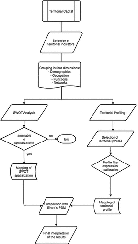
SWOT analysis is a strategic planning technique used to identify strengths, weaknesses, opportunities, and threats related to a project. In spatial planning it is widely used to identify the internal and external factors that are at play, and to mitigate or control existing drawbacks or threats to development. However, these SWOT analyses are usually ‘place-blind’, providing a writing list of features of the territory under assessment. Such a representation fails to show where those features emerge in the territory and where they do not. The proposed model of territorial capital assessment performs a spatialization (i.e. a spatial mapping) of such features, locating on a map where each SWOT item has lower or higher scores in each category. Although not all features of a SWOT analysis have a spatial dimension, it is important to tackle those that have it as they reveal patterns of spatial distribution in the territory.
In the context of strategic planning, the proposed territorial capital assessment model can also be applied during a conventional scenario evaluation phase. In order to assess the suitability of pre-defined development scenarios for different locations, the set of territorial capital indicators () is used to create a series of territorial profiles. These territorial profiles are defined by aggregating scores from a relevant selection of territorial capital indicators that reflect the specific development scenario. Territorial profiles are maps that spatially show the potential of locations for each scenario. This method makes it possible to objectively compare the territorial capital of one location with another, for each specific scenario, and to predict possible development paths for each location in the territory.
3.2. Sintra case study
3.2.1 Description of Sintra’s territory
Sintra is part of the Metropolitan Area of Lisbon (MAL) and it is the second most populated municipality of Portugal, after Lisbon, with 385.954 inhabitants (2021). Its territory covers 319 Km2 and is characterized by a variety of landscapes, land uses, and settlement patterns, with a wide diversity of features and territorial capital advantages. Five main territorial units can be highlighted (Câmara Municipal de Sintra, Citation2019): i) the northern Atlantic coast and agricultural area, a rural area with scattered small urban settlements and a high potential for tourism, especially along the coastline; ii) the industrial and logistics zone, an area of specialized industrial and productive clusters, including quarries and stone factories, with good accessibility and an entrepreneurial environment; iii) the urban axis, a continuous urban strip developed along the railway line to Lisbon city centre and situated between two highways (IC19 and A16); iv) Sintra’s historical town and forestry area, a UNESCO heritage site that includes Sintra’s historical town and the mountains, with a high natural, ecological and landscape potential; and v) the rural hinterland, a wetland of larger holdings with strong agricultural potential.
Such diversity offers an array of territorial potentials with different possible development scenarios (e.g. polycentric urban development; innovation and development clusters; cultural tourism), which were developed during the revision of Sintra’s Municipal Master Plan (2012–2019) by municipal planners and local officials. These scenarios are a key element in the approved Spatial Development Model (SDM) - a strategic planning instrument with a spatial development vision for the entire Sintra region in the medium and long term future. By adopting Sintra as a case study, this research offers an opportunity to test how the territorial capital assessment model could inform the different development scenarios and the overall SDM.
In order to test the territorial capital assessment model, based on both SWOT analysis and development scenario evaluation, we chose to apply it to the polycentric development scenario. This made it possible for us to address one of the main challenges identified by the municipality of Sintra: how to deal with urban sprawl – a problem that, excluding the mountain areas, affects almost the entire region and the different territorial units. Taking advantage of Sintra’s territorial capital, the spatial planning objective is to foster the re-urbanization of the region towards a polycentric urban system. Based on both the ‘givens’ and ‘position’ of Sintra’s territorial capital (cf. Zonneveld & Waterhout, Citation2005, p. 19), the objective is to understand which locations are best suited for further urban development and densification, while safeguarding others from urbanization.
3.2.1 Calculation of the territorial capital in the case study
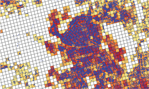
For Sintra case study, the set of indicators presented in Section 3.1.1 () was calculated using publicly available data from the National Institute of Statistics (INE), OpenStreetMap, and the European Environmental Agency (EEA), as well as data obtained from web-scraping business directories (i.e. the location and type of economic activities). Geographic Information Systems (GIS) software was then used to carry out the spatial analysis of territorial capital based on the indicators mentioned above. As the indicators used multiple data sets of different nature (e.g. population per statistical unit; buildings; economic activities) and with different spatial units (e.g. statistical parish; subsection; address coordinates), the data were harmonized at a higher spatial resolution. Based on a process of data disaggregation and subsequent re-factoring, the indicators were translated into a 1hectare (100 m x 100 m) grid, then their values were scaled, and finally they were converted to a score system from 1 to 5 (). This harmonization process enables the integration of indicators in a common assessment framework, and the comparison of indicators between scenarios.
Figure 2. Disaggregation and scoring of building intensity into the 1hectare grid cells.
3.3. Applying the territorial capital model to the case of Sintra
The model was applied for both possibilities (SWOT analysis spatialization; and territorial profiling for scenario evaluation – viewing Sintra as a polycentric territory).
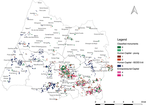
The SWOT analysis spatialization translated the traditional SWOT analysis of Sintra’s Municipal Master Plan (2019) into a more spatially explicit decision-support tool. The plan states that being ‘the second most populated municipality of the country, with a multicultural, diverse, and young population, increasingly educated and qualified’ is one of Sintra’s strengths. Using the indicators of human capital, this strength can be visualized in a map, as exemplified in , showing the spatial distribution of the highly educated population. Furthermore, multiple SWOT aspects can be jointly mapped and compared. In , different strengths related to human, cultural and entrepreneurial capital are combined in a single map. Only the locations with the highest scores for each strength are mapped (e.g. the highest score of population with education levels ISCED 5–8), which shows a concentration of territorial capital strengths along the urban axis and in locations of high-income households and second homes.
Figure 3. Example of a human capital indicator spatializing one of Sintra’s strengths: share of population with higher levels of education (ISCED 5–8).
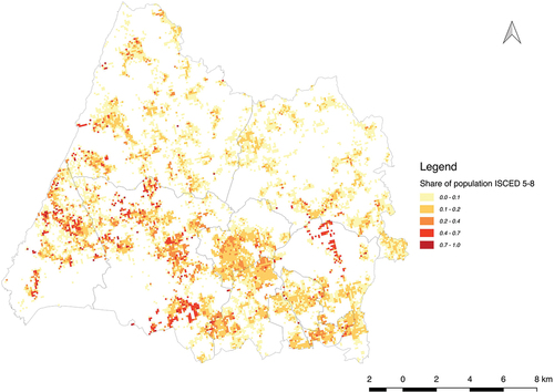
Figure 4. Example of Sintra’s SWOT analysis spatialisation: combining the strengths category in a single map.
During the scenario evaluation phase of the SDM of Sintra, presented in Section 3.2., the territorial profiling of the territorial capital model was applied. The aim was to assess the potential of each location in the territory to meet the goals set by the municipality in a specific development scenario based on its territorial capital. To test this, we focused on the strategic goal of developing Sintra as a polycentric territory. Six territorial profiles were identified from the description of the development scenario: Lively Urban Centers; Not Lively Urban Centers; Lively Dispersed Area; Not Lively Dispersed Area; Dispersed Area with Potential to become a Place; Dispersed Area with Potential to become a Node. We then defined each territorial profile based on a combined set of territorial capital indicators () and produced maps of the locations that meet the indicator scores required by each profile. The aim was to provide SDM with a layer of information based on an integrated and multivariate criteria evaluation – the proposed territorial profiling – that more intuitively would identify areas with specific potential and which are, therefore, more likely (or not) to strengthen Sintra’s urban system as a polycentric territory.
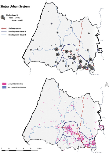
As an example, one can compare the map of the current urban system as presented by the municipality with the territorial profiling based on the proposed model. Looking at the overlapping of the areas identified as level 1 nuclei ( top) and the locations with a territorial profile of Lively Urban Center or a Not Lively Urban Center ( bottom), and considering that the strategic goal is to reinforce the centrality of locations with a central role in the system, we can see to what extent such locations have a territorial capital for an increasingly central role in the system. Thus, the spatial resolution of the map can support place-based decision-making.
Figure 5. Sintra’s urban system according to the municipal master plan (top) and based on territorial profiling of lively urban centers versus not lively urban centers (bottom).
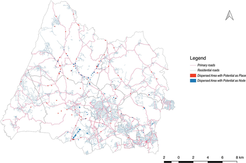
Another example is mapping extensive dispersed territories to address the goal of re-urbanization of areas affected by urban sprawl. The territorial profiles Dispersed Areas with Potential to become a Place or Dispersed Areas with Potential to become a Node () show locations whose territorial capital’s characteristics suggest a potential for urban intensification or re-urbanization regardless of the current urban sprawl: due to their location and integration in the network – position; due to a greater concentration or diversification of activities and people; or due to some other factor or asset – givens. The spatial identification of these scattered locations, which can support densification and re-urbanization, may be of interest for the strategic consolidation of Sintra’s urban system.
Figure 6. Re-urbanization potential development map for dispersed areas with potential to become a place or a node.
4. Discussion
The territorial turn in regional policies and the increasing convergence between spatial planning and regional development policies call for novel integrated multidisciplinary approaches. Territorial governance, as much as territorialization, place-based, and tailor-made strategic visions claim for new methodologies and tools to cope with the still fragmented and often abstract planning processes, split into a myriad of parallel a-spatial programs and policies.
One of the challenges lies in the integration and spatialization of territorial data, given the multiplicity and interrelation of territorial systems and localized assets that hold the potential of an area to be developed. Originating from the field of regional economics, the concept of territorial capital emerged with the purpose of dealing with this tangle of factors and resources that support territorial development. However, existing multivariate statistical methods for assessing territorial capital (Camagni et al., Citation2011; Pompili & Martinoia, Citation2011; Capello & Fratesi, Citation2012) are based on large scale quantitative indicators (e.g. NUTS 3), which are, therefore, insufficient to deliver territorial capital in a fine-grained spatial and visual representation, required to support strategic spatial planning and regional design efforts. This research stemmed from an ambition to bridge the gap.
With this in mind, we decided to develop a model that could be the missing link between the two roads mentioned by Zonneveld and Waterhout (Citation2005) when considering the territorial dimension of EU policies: ‘learning to think technically’, i.e. technical processes that call for quantitative indicators; and ‘learning to think spatially’, i.e. visioning exercises that require spatial data and imaging. By providing territorial data – usually expressed in numeric form – and strategic guidelines – usually expressed in verbal form – with spatial representation, the proposed model seeks to support a deeper and more place-specific territorial analysis, strategic visioning, and governance. The proposed territorial capital assessment model takes a step forward by spatializing the concept of territorial capital based on a fine-grained multivariate method, suitable to support the development of design-led planning scenarios and strategies at a regional level. Several contributions of the proposed model foreground spatial planning and regional design.
The first one is the delivery of territorial capital as a high-resolution spatial-led concept. Unlike other methods, the proposed approach addresses the spatialization of territorial capital as a process sensitive to the multiplicity of landscape patterns and geographies (physical, environmental, social and economic) that shape regional identity. For this purpose, the proposed territorial capital assessment model offers a set of indicators with high spatial resolution (1-hectare grid cells) and multiple discrete levels (scores) that are combined to show diverse territorial patterns. This spatial sensitivity, novel in territorial capital studies, is crucial to support tailor-made approaches and, therefore, regional design as a site-specific and context-oriented approach. Furthermore, it overcomes the limitations of binding territorial analyses and classifications to administrative boundaries (Dijkstra et al., Citation2021), and paves the way for soft planning spaces and governance rescaling (Lingua & Balz, Citation2019). In Sintra, thanks to the spatialization and integration of territorial capital in a fine-grained resolution, it was possible to identify the spatial arrangements of different sources of capital (i.e. human, social, infrastructural, relational, economic, entrepreneurial), as much as the spatial patterns of their combinations, and raise awareness of the spatial distribution of Sintra’s territorial potential.
The second one is the underlying strategic orientation of the proposed model. Unlike other territorial capital approaches that support decision-making with quantitative indicators, this model works with two established methodologies of strategic thinking: SWOT analysis and scenario-planning. First, by spatializing the results of a traditional SWOT analysis, territorial capital is included in the planning process and offers an innovative way of materializing SWOT results. Then, by applying the model to support scenario-building and evaluation, it becomes possible for strategic spatial planning and regional design to imagine and test future visions and, therefore, guide decision-making accordingly. Indeed, one of the main aims of this work is to show the value of data-driven spatial analyses and territorial profiling in conceiving, designing and monitoring strategic spatial plans for extended areas. In Sintra, following the municipality’s decision to promote a polycentric territorial development in a rather extensive and diffuse urbanization context, the proposed territorial capital model – based on territorial profiling – provided a better understanding of the inherent dynamics of the territory. It unveiled a possibility for selective re-urbanization processes, i.e. it defined which areas should be considered for further urban development and consolidation and which areas should be safeguarded. Thus, the proposed methodological approach is a valid decision-support system that can integrate relevant features for territorial capital analyses and provides prompt information to scenario-planning, suitable to the specific goals of the planning task at hand. The polycentric development scenario, used to test the application of the model in the case study, is merely an example of the myriad scenarios and territorial profiles that can be developed according to the specificities of each place and context.
Last but not least, there are the visual characteristics of the proposed approach. Besides spatializing territorial capital, it also enables its visual representation and communication. This is particularly interesting for design-led planning processes as their work is based on maps and spatial models. Moreover, this model can be an easy-to-read tool, allowing non-experts to join the planning process effortlessly when the established practices of regional design are especially focused on supporting governance processes – involving different actors and stakeholders and engaging them through argumentation and negotiation.
However, this needs further research with both experts and non-experts clearly using these tools in order to test and develop communication principles of territorial patterns. The potentially large number of maps resulting from applying the model needs to be limited to what can be comprehended by different users. The visual qualities of different layers of information, their attributes, and their value ranges or scores, must be studied to provide effective and meaningful support to design and decision-making.
Setting the territorial capital indicators and transforming scenario goals into territorial profiles are the major challenges of the proposed model. While the dimensions and indicators () are suitable to the concept of territorial capital in every case, the proposed specific measurements are empirically defined from the data available for this specific case study. Hence, this process needs to be repeated for other cases. Likewise, transforming scenario goals into territorial profiles is a process that depends on the subjective interpretation of those goals by the project team, and on the selection and calibration of the available territorial capital indicators, turning them into scores that represent those goals in the territory. These operations are inevitably subjective and must be carried out as a collective effort between experts, planners, and other stakeholders to reach an agreement on how to represent both territorial capital indicators and territorial profiles.
5. Conclusions
Regional design is a spatial planning approach and methodology to envision desirable futures for regions and territories, aiming at governance-based and development-oriented strategic visions (Neuman, Citation2000; Neuman & Zonneveld, Citation2018, Citation2021; Lingua & Balz, Citation2019). Due to its focus on spatial parameters and the governance arrangements to be implemented, on regional territory analysis, and on design-led visioning, regional design is suitable to solve the challenge of aligning spatial planning and regional development policies. However, as Neuman and Zonneveld point out (Neuman & Zonneveld, Citation2021, p. 447), despite recent advancements on data, algorithms, and flows-related tools, ‘new methods, new thinking, new learning, and new teaching’ are still needed. The proposed territorial capital assessment model can lay the foundations for supporting regional design approaches in several aspects.
Based on Kempenaar and van den Brink’ regional design principles (Kempenaar & van den Brink, Citation2018), the proposed territorial capital assessment model can: (i) support regional design as a ‘dynamic systems perspective’ by allowing thorough analyses and representation on how territorial systems evolve and change; (ii) address ‘multiple geographical scales’ by simultaneously covering large geographical areas and specific places and exploring the relationship of each location with other locations and the entire region; (iii) look ‘from history to future’ by establishing a direct connection between territorial analysis and scenario-building; (iv) support ‘a continuing dialogue with stakeholders’ by offering a visual-based and easy-to-read tool that makes it easier for stakeholders to follow planning endeavours and actively participate in decision-making; (v) deliver ‘sensing and responding’ feedback while balancing ‘direction and openness’, by blending multivariate data and easily framing iterative processes of analysis-versus-assessment and representation-versus-prospective visioning; (vi) and, especially, endorse the ‘reframing [of] the region’ by providing a territorial profiling tool that supports scenario-building and evaluation, a central output of this multidimensional model.
Regional design needs a solid information base to avoid becoming just an arbitrary practice. This can be achieved by using data for modelling and visualizing territorial dynamics in a design-led approach, which can support planners and stakeholders making informed decisions in complex environments. In addition, by making connections between different fields of work and knowledge (e.g. regional economics, spatial planning, territorial statistics; GIS and other computational tools applied to territorial analysis), the proposed methodological approach and assessment model contributes to bridging the gap between the goals of regional development – to promote endogenous development and foster regional competitiveness while ensuring territorial cohesion – and the spatial planning mission – to shape territorial development through the coordination of sector-wide policies.
Acknowledgments
Authors acknowledge the Portuguese Fundação para a Ciência e a Tecnologia (FCT), for funding the research project SOFTPLAN - From Soft Planning to Territorial Design: Practices and Prospects (Ref. nº PTDC/GES-URB/29170/2017).
Francesco Orsi also acknowledges the financial support of the Fundacão para a Ciência e a Tecnologia (FCT) through the PhD Grant Ref. N.º FCT SFRH/BD/88939/2012.
Disclosure statement
No potential conflict of interest was reported by the author(s).
Additional information
Funding
References
- Adams, N., Alden, J., & Harris, N. (Eds) (2006) Regional Development and Spatial Planning in an Enlarged European Union (Hampshire: Ashgate). Available at http://library1.nida.ac.th/termpaper6/sd/2554/19755.pdf
- Barca, F. (2009) An agenda for a reformed cohesion policy. A place-based approach to meeting European Union challenges and expectations. Available at https://ec.europa.eu/regional_policy/archive/policy/future/pdf/report_barca_v0306.pdf
- Barca, F., Mccann, P., & Rodríguez-Pose, A. (2012) The case for regional development intervention: Place-based versus place-neutral approaches, Journal of Regional Science, 52(1), pp. 134–152. doi:10.1111/j.1467-9787.2011.00756.x.
- Berghauser Pont, M. (2010) Spacematrix. Space, Density and Urban Form (Rotterdam: NAi Publishers).
- Camagni, R. (2007) Towards a concept of territorial capital. In: XXVIII Conferenza Italiana di Scienze Regionali, Milan, pp. 1–17.
- Camagni, R. (2009) Territorial capital and regional development, In: R. Capello & P. Nijkamp (Eds) Handbook of Regional Growth and Development Theories, pp. 118–132 (Northampton, Massachusetts: Edward Elgar Publishing).
- Camagni, R., & Capello, R. (2013) Regional competitiveness and territorial capital: A conceptual approach and empirical evidence from the European Union, Regional Studies, 47(9), pp. 1383–1402. doi:10.1080/00343404.2012.681640.
- Camagni, R., Caragliu, A., & Perucca, G. (2011) Territorial capital. relational and human capital. Il Capitale Territoriale: Scenari quali-quantitativi di superamento della crisi economica e finanziaria per le province italiane, Milan. Available at http://www.grupposervizioambiente.it/aisre/pendrive2011/pendrive/Paper/Camagni_Caragliu_Perucca.pdf
- Câmara Municipal de Sintra. (2019) Plano Diretor Municipal. Proposta de Plano (Sintra: Relatório).
- Capello, R., Caragliu, A., & Nijkamp, P. (2009) Territorial capital and regional growth: increasing returns in cognitive knowledge use. Tinbergen Institute Discussion Papers. Available at http://ideas.repec.org/p/dgr/uvatin/20090059.html
- Capello, R., & Fratesi, U. (2012) Modelling regional growth: An advanced MASST model, Spatial Economic Analysis, 7(3), pp. 293–318. doi:10.1080/17421772.2012.694143.
- Cavaco, C., & Costa, J.P. (2019) Administrative organisation and spatial planning in Portugal: A push towards soft planning spaces in Europe?, in: Shaping Regional Futures. Designing and Visioning in Governing Rescaling, pp. 87–101 (Cham: Springer). doi:10.1007/978-3-030-23573-4.
- Cavaco, C., Mourato, J., Costa, J. P., Pereira, A., Vilares, E., Moreira, P., & Magalhães, M. (2021) Spatial Planning and Regional Development in Portugal (Lisboa: Direção-Geral do Território).
- CEMAT. (2007) Spatial development glossary. European conference of ministers responsible for spatial/regional planning (CEMAT). Territory and landscape. Territory and Landscape No 2 September (Strasbourg: Council of Europe Publishing).
- Chakraborty, A., & McMillan, A. (2015) Scenario planning for urban planners: Toward a practitioner’s guide, Journal of the American Planning Association, 81(1), pp. 18–29. doi:10.1080/01944363.2015.1038576.
- Costa, P., Brito-Henriques, E., & Cavaco, C. (2021) Interim reuse in urban derelicts: Uncovering the community`s attitudes and preferences through scenario-elicitation, Cities, 111, pp. 103103. doi:10.1016/j.cities.2021.1031103.
- Danielewicz, J., & Turala, M. (2016) Territorial capital as a determinant of development processes in functional areas, Folia Oeconomica, 2(319), pp. 55–68. doi:10.18778/0208-6018.319.04.
- Davoudi, S., Evans, N., Governa, F., & Santagelo, M. (2008) Territorial governance in the making. Approaches, methodologies, practices, Boletín de la Asociación de Geógrafos Españoles, 46(January), pp. 33–52.
- De Rubertis, S., Ciavolino, E., & Labianca, M. (2019) Rethinking Territorial capital, Bollettino della Societa Geografica Italiana, 158(2), pp. 91–104. doi:10.13128/bsgi.v2i3.715.
- Dijkstra, L., Florczyk, A.J., Freire, S., Kemper, T., Melchiorri, M., Pesaresi, M., & Schiavina, M. (2021) Applying the degree of urbanisation to the globe: A new harmonised definition reveals a different picture of global urbanisation, Journal of Urban Economics, 125, pp. 103312. doi:10.1016/j.jue.2020.103312.
- European Commission. (2006) The Territorial State and Perspectives of the European Union Document Towards a Stronger European Territorial Cohesion in the Light of the Lisbon and Gothenburg Ambitions (Brussels).
- European Union. (2011) Territorial agenda of the European Union 2020. Towards an inclusive, smart and sustainable Europe of diverse regions (Godollo, Hungary: European Union). Available at https://ec.europa.eu/regional_policy/sources/policy/what/territorial-cohesion/territorial_agenda_2020.pdf
- Ferrão, J. (2014) O Ordenamento Do Território Como Política Pública, 2a Edição (Lisboa: Fundação Calouste Gulbenkian).
- Fratesi, U., & Perucca, G. (2020) EU regional policy effectiveness and the role of territorial capital, In: T. S. Della; S. Cattaneo, C. Lenzi, & A. Zanelli (Eds) Regeneration of the Built Environment from a Circular Economy Perspective, pp. 29–37 (Cham, Switzerland: Springer). doi:10.1007/978-3-030-33256-3_6.
- Gruber, M., Kanonier, A., & Pohn-Weidinger, S. (2018) Spatial Planning in Austria with References to Spatial Development and Regional Policy (Vienna: OROK - Office of the Austrian Conference on Spatial Planning).
- Kempenaar, A., & van den Brink, A. (2018) Regional designing: A strategic design approach in landscape architecture, Design Studies, 54, pp. 80–95. Elsevier Ltd. doi:10.1016/j.destud.2017.10.006.
- Kitchin, R., & Dodge, M. (2007) Rethinking maps, Progress in Human Geography, 31(3), pp. 331–344. doi:10.1177/0309132507077082.
- Kunzmann, K. (2006) The Europeanization of spatial planning, In: N. Adams; J. Alden, & N. Harris (Eds) Regional Development and Spatial Planning in an Enlarged European Union, pp. 43–67 (Hampshire: Ashgate).
- Lingua, V., & Balz, V. (Eds) (2019) Shaping Regional Futures. Designing and Visioning in Governing Rescaling (Cham: Springer). doi:10.1007/978-3-030-23573-4.
- Manaugh, K., & Kreider, T. (2013) What is mixed use? Presenting an interaction method for measuring land use mix, Journal of Transport and Land Use, 6(1), pp. 63–72. doi:10.5198/jtlu.v6i1.291.
- Nadin, V. (2006) The role and scope of spatial planning: A literature review. Spatial plans in practice. Supporting the reform of spatial planning, London. Available at https://www.academia.edu/10848965/The_Role_and_Scope_of_Spatial_Planning_A_Literature_Review
- Nadin, V., Piskorek, K., Balz, V., Zonneveld, W. A., Unceta, P. M., Georgieva, N. D., den Hoed, A.W., Hermansons, Z., & Daly, G. (2021) Policy Brief//Cross-Fertilisation of Cohesion Policy and Spatial Planning (Luxembourg: ESPON EGTC).
- Neuman, M. (2000) Regional design: Recovering a great landscape architecture and urban planning tradition, Landscape and Urban Planning, 47(3–4), pp. 115–128. Elsevier. doi:10.1016/S0169-2046(99)00079-1.
- Neuman, M., & Zonneveld, W. (2018) The resurgence of regional design, European Planning Studies, 26(7), pp. 1297–1311. Taylor & Francis. doi:10.1080/09654313.2018.1464127.
- Neuman, M., & Zonneveld, W. (Eds) (2021) The Routledge Handbook of Regional Design (New York and London: Routledge). doi:10.4324/9780429290268.
- Newman, P. (2008) Strategic spatial planning: Collective action and moments of opportunity, European Planning Studies, 16(10), pp. 1371–1383. doi:10.1080/09654310802420078.
- OECD. (2001) OECD Territorial Outlook (Paris: OECD Publications). doi:10.1787/9789264189911-en.
- OECD. (2010) Regional Development Policies in OECD Countries (Paris: OECD Publications). doi:10.1787/9789264087255-en.
- Pompili, T., & Martinoia, M. (2011) Building synthetic indicators for aspects of territorial capital. In: European Regional Science Association. 51st European Congress, Barcelona, pp. 1–30. Euroepan Regional Science Association. Available at https://ideas.repec.org/p/wiw/wiwrsa/ersa11p1528.html
- Purkarthofer, E., & Mattila, H. (2018) Integrating regional development and planning into “spatial planning” in Finland: The untapped potential of the Kainuu experiment, Administrative Culture, 18(2), pp. 149–174. doi:10.32994/ac.v18i2.166.
- Schiuma, G., & Lerro, A. (2008) Knowledge‐based capital in building regional innovation capacity, Journal of Knowledge Management Carrillo FJ (ed.), 12(5), pp. 121–136. Emerald Group Publishing Limited. doi:10.1108/13673270810902984.
- Simpson, E.H. (1949) Measurement of diversity, Nature, 163(4148), pp. 688. doi:10.1038/163688a0.
- Soria-Lara, J.A., Zúñiga-Antón, M., & Pérez-Campaña, R. (2015) European spatial planning observatories and maps: Merely spatial databases or also effective tools for planning?, Environment and Planning: B, Planning & Design, 42(5), pp. 904–929. doi:10.1068/b130200p.
- Storper, M. (1997) Territories, flows and hierarchies in the global economy, In: K. Cox (Ed) Spaces of Globalization. Reasserting the Power of the Local, pp. 19–44 (New York and London: The Guilford Press).
- Thoidou, E. (2011) The territorial approach to eu cohesion policy: Current issues and evidence from greece, Spatium, 2(25), pp. 7–13. doi:10.2298/SPAT1125007T.
- Tóth, B.I. (2015) Territorial capital: theory, empirics and critical remarks, European Planning Studies, 23(7), pp. 1327–1344. doi:10.1080/09654313.2014.928675.
- Van Herzele, A., & van Woerkum, C. (2011) On the argumentative work of map-based visualisation, Landscape and Urban Planning, 100(4), pp. 396–399. Elsevier B.V. doi:10.1016/j.landurbplan.2011.02.013.
- van Notten, P.W.F., Rotmans, J., van Asselt, M.B.A., & Rothman, D. S. (2003) An updated scenario typology, Futures, 35(5), pp. 423–443. doi:10.1016/S0016-3287(02)00090-3.
- Zonneveld, W., & Waterhout, B. (2005) Visions on territorial cohesion, The Town Planning Review, 76(1), pp. 15–27. doi:10.3828/tpr.76.1.2.