Abstract
Geographic tools for the analysis of spatially referenced information now serve the research needs for a broad range of academic disciplines and public purposes. Nonetheless, the diffusion of spatial technologies into the curricula of most disciplines remains limited. This article reviews initiatives of the Center for Spatially Integrated Social Science (CSISS) to address this problem through a programme of national dissemination in the United States. The experiences of its Spatial Perspectives on Analysis for Curriculum Enhancement (SPACE) programme are probed for guidelines on structuring workshops to serve undergraduate instructors in their efforts to advance spatial thinking in the social sciences.
Introduction
In the past decade, significant interest has emerged beyond the traditionally spatial disciplines, such as geography or geology, to engage the analytical and theoretical understandings that can arise from adopting spatial perspectives and methodologies. In the social sciences, special issues of leading national and international journals have featured the role of maps in visualizing geographically referenced social data, geographic information systems (GIS) for exposing spatial relationships among variables and geographical patterns, and spatial econometrics for exploratory data analysis and model building. Examples include the Journal of Quantitative Criminology 1999, 15 (4); Social Science History 2000, 24 (3); Geographical & Environmental Modelling 2001, 5 (1); Agricultural Economics 2002, 27 (3); Political Analysis 2002, 10 (3); Political Geography 2002, 21 (2); Rural Sociology 2002, 67 (4); International Regional Science Review 2003, 26 (3); Journal of Economic Geography 2004, 4 (1); Proceedings of the National Academy of Sciences 2005, 102 (43); American Journal of Preventive Medicine 2006, 30 (2); Geographical Analysis 2006, 38 (1); Environmental and Ecological Statistics 2007, 14 (1&2, 3); Population Research Policy Review 2007, 26; and the Journal of Econometrics 2007, 140 (1). The increasing availability of geo-referenced data, improvements in spatial software and Internet-enhanced accessibility to resources and training opportunities are contributing factors to this growing interest, but it is also a consequence of the important roles played by research funding agencies, academic organizations and businesses worldwide.
This article focuses on the role of one such organization, CSISS, and one of its programmes to extend spatial analytic thinking to the education of undergraduate social science students in the United States. CSISS was founded in 1999 with funding from the National Science Foundation (NSF) to develop research infrastructure for spatial analysis in the social and behavioural sciences.(Footnote1 Its approach to integrating knowledge across disciplines, reviewed in detail by Janelle and Goodchild (Citation2009a), focused on expanding the number of users (and types of uses) of spatial analytic tools for investigating critical issues in the social and behavioural sciences. Its multiple initiatives, including the development of spatial software tools (Rey & Anselin, Citation2006), publications (Goodchild & Janelle, Citation2004), web resources and research conferences were part of a broad strategy to enhance the infusion of spatial methodologies into the social sciences. However, one of the most important strategies for fostering principles of spatially integrated social science (see Goodchild et al., Citation2000; Janelle & Goodchild, Citation2006) was a programme of residential training workshops.
Over the summers 2000–2008, more than 800 scholars received CSISS training in such technologies as GIS, cartographic visualization of social science data, remote sensing, spatial econometrics, spatial demography, and spatial data modelling. Workshops focused on a young cohort of researchers (e.g. PhD candidates and un-tenured professors), based on the rationale that dissemination would proceed through the demonstrations and the effects of improved scientific understanding for dissertations, publications and grant proposals by active scholars. It was also anticipated that this approach would foster the inclusion of spatial methodologies in instructional practices at graduate and undergraduate levels.
Structuring a Workshop Programme for Undergraduate Instructors in the Social Sciences
One of the CSISS training initiatives, featuring 11 six-day-long residential workshops, was directed explicitly to serving the needs of undergraduate instructors in the social sciences—Spatial Perspectives on Analysis for Curriculum Enhancement (http://www.csiss.org/SPACE).Footnote2 SPACE offered its first set of workshops in summer 2004. By summer 2007, 218 university instructors and PhD candidates had been introduced to applications of spatial tools to help enhance the integration of spatial thinking for undergraduates across the social sciences. SPACE promoted the value of spatial thinking and associated technologies as a basis for integrating knowledge among disciplines and motivating students through project-based learning on applications relevant to understanding society.
In SPACE workshops, participants lived together in university dormitory settings, and took part in intensive daily training and discourse. Although there was a focus on selecting early-career scholars, participants spanned academic generations, and workshop activities encouraged collaborative networks among participants by stressing the commonality of the spatial perspective to problem identification and to research and teaching approaches. As illustrated in Table , the disciplinary mix of SPACE participants spanned a range of knowledge domains; interest in workshop participation exceeded capacity by a significant margin.
Table 1. SPACE workshop participants and applicants 2004–2007
The balance of this article draws on experiences from SPACE workshops and on the organization of a programme to engage social science instructors in discourse on enhancing the spatial analytic skills of undergraduate students. Topics covered include workshop goals and objectives, participant selection, content and structure, curricular resources, pedagogic principles, workshop outcomes and leveraging workshops for national dissemination. It was the objective that SPACE workshops be vehicles for sustained dissemination of spatial thinking in the social sciences.
Workshop Goals and Objectives
SPACE's specific goal was to assist faculty in becoming innovative teachers in the use of spatial analysis, enabling them to provide opportunities for their students to work directly with geo-referenced databases and the latest software. Correspondingly, each workshop featured outstanding computer and instructional facilities as well as support from workshop leaders recognized for their ability to communicate across disciplinary boundaries. Hands-on experience and customized support for each workshop participant were of critical importance to achieving workshop outcomes that participants could then transfer to their home institutions. The general objectives of the workshops were to:
| • | demonstrate the value of knowledge integration through a common focus on spatial perspectives for enhanced understanding of problems traditional to the social sciences, a goal consistent with recent high-profile statements on the importance of the spatial perspective (Colwell, Citation2004; Butz & Torrey, Citation2006); | ||||
| • | promote the integration of technology in undergraduate education by exposing workshop participants to software tools that are both fiscally affordable for their institutions and cognitively accessible for their students; | ||||
| • | establish and encourage support networks based on strong peer-to-peer interaction throughout the workshop period and in follow-up activities; and | ||||
| • | lay the foundation for broad national dissemination of spatial thinking in the social sciences. | ||||
Participant Selection
The applicant pool for SPACE workshops was sufficiently large to allow diversity based on discipline, gender and type of academic institution (e.g. liberal arts and technical colleges, and comprehensive research universities). Thus, nearly 20 per cent of workshop invitees were instructors from what the NSF designates as minority-serving institutions (Historically Black Colleges and Universities (HBCUs), Hispanic Serving Institutions, and Tribal Colleges); and women accounted for 52 per cent of participants over the 11 workshops. Diversity is regarded by NSF as a key factor in achieving national dissemination, providing opportunities to advance student learning with technologies that reflect growth in economic opportunity Gerwin, Citation2004).
Having a large number of applicants from which to choose enabled a good fit between the expectations of the workshop leaders and the experience and abilities of participants. Thus, although individuals with faculty appointments were preferred for this programme, a limited number of PhD candidates (who showed a strong commitment to teaching undergraduate students) were invited to participate. Participants agreed to include spatial perspectives and analysis in their undergraduate courses and to complete follow-up surveys on their uses of the workshop experience to enhance undergraduate courses and curricula. In general, programme applicants were comfortable with quantitative methodologies in the social sciences, although not necessarily from a spatial perspective.
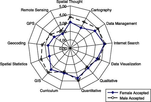
Online application and entry surveys provided profiles for tailoring workshops to meet participant needs. (Figure provides an example of participants' self-assessment of their prior knowledge and familiarity with the tools of spatial and quantitative analysis, and of their background for dealing with curricula issues. In general, male applicants expressed higher confidence in their technical skills than female applicants, while female applicants scored higher than males on qualitative analysis and familiarity with issues in curriculum development. The average values shown in Figure are for participants in the three 2006 workshops. Similar graphics for each workshop helped to differentiate participant needs and structure workshop content.
Figure 1 Radial graph of average self-assessment of knowledge by entering participants in the 2006 SPACE workshops. Note: Scalar values included 1 = no familiarity, 2 = awareness, 3 = use in research, 4 = capable of teaching, and 5 = expert.
Structuring Workshop Content
The actual structuring of the workshop agenda considered the characteristics of the participant group—their disciplines, prior knowledge and experiences—and stated personal objectives for participating, as determined by their responses in application and entry surveys. Using one of the workshops at the University of California, Santa Barbara (UCSB) as an example, the workshop's structure was sufficiently flexible to permit participant requests for topical discussions or instruction and for one-on-one consultation.
Figure provides a graphic summary of the workshop syllabus for the 2007 workshop at UCSB (see full agenda at http://www.csiss.org/SPACE/workshops/2007/UCSB/agenda.php). The five columns (time arrows) reflect the general sequence of activities over the six days; from left to right, they represent:
| • | general logistics for academic and social events;
Figure 2 Workshop Agenda (graphic syllabus by Stacy Rebich-Hespanha) 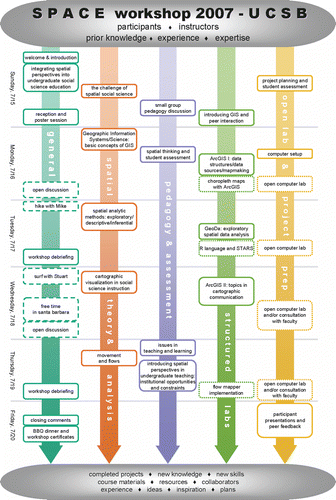 | ||||
| • | linking spatial theory and analysis with social science perspectives; | ||||
| • | alignment of theory and analysis skills with pedagogic needs and assessment of student learning; | ||||
| • | structured labs for the development of technical skills; and | ||||
| • | preparation of individual projects for presentation on the final day of the workshop. | ||||
Learning and Teaching Resources
Participants reviewed the extensive resources available on the CSISS and SPACE websites and other online collections in their preparations for the workshop. Through the CSISS Learning Resources portal at http://www.csiss.org/learning_resources, they had access to such resources as the following:
| • | the CSISS GIS Cookbook—simple tutorials on basic GIS operations aimed at social scientists with minimum knowledge of GIS and its underlying principles and minimal knowledge of geography; | ||||
| • | CSISS edited video clips—presentations by instructors from prior workshops on Map Making and Visualization of Spatial Data in the Social Sciences; Spatial Pattern Analysis in a GIS Environment; and Geographically Weighted Regression (Fotheringham et al., Citation2002); | ||||
| • | The CSISS Classics—a collection of vignettes that feature summary discussion of contributions to spatial thinking by social scientists. The Classics give primary emphasis to research before 1980, with an attempt to capture and acknowledge the repository of spatial thinking from such disciplines as anthropology, economics, geography, history, political science, sociology, and urban studies over the past few centuries. This collection, visited by approximately 30 000 visitors per month, documents some of the intellectual inheritance of spatial thinking by social scientists and is a useful resource for students. | ||||
The spatial tools page (http://www.csiss.org/clearinghouse/) enabled the downloading of spatial statistics software, including:
| • | GeoDa™ for exploratory spatial data analysis?one of the primary software tools used in SPACE workshops. Aside from its value as a serious research tool, it provides an excellent resource for engaging undergraduate social science students in rigorous data analysis and visualization exercises (Rey & Anselin, Citation2006). | ||||
| • | FlowMapper, developed by Waldo Tobler for mapping flows from interaction matrices, was another easy-to-use tool appropriate for exercises to use in undergraduate teaching. | ||||
In addition, the SPACE site offered an assembly of resources organized by discipline (including syllabi and exercises) and information on learning assessment and curriculum development. Guides for selecting GIS software and for using virtual globes (e.g. Google Earth) were oriented to applications in teaching. A special collection of instructional innovations from prior workshop participants illustrated the benefits of the SPACE programme and provided pedagogic guidance for other social scientists seeking to adopt spatial perspectives in teaching (http://www.csiss.org/SPACE/materials/participants/).
Workshop Pedagogy
A primary concern of workshop organizers was to facilitate the transfer of the workshop experience to undergraduate teaching. This transfer influenced all aspects of workshop planning and was guided by the following questions:
| • | How can materials and concepts presented in workshops be reconciled with what participants can teach in their undergraduate courses? | ||||
| • | How can workshops be structured to illustrate the benefits of alternative teaching formats that participants might use to enhance the learning of their undergraduate students? | ||||
| • | How can workshops encourage and equip participants to adopt learning assessment practices with their students? | ||||
| • | How can workshops engage participants in useful strategies for finding and manipulating relevant data for use in their undergraduate teaching? | ||||
| • | What strategies might be used to encourage greater use of SPACE website resources by workshop participants and their students? | ||||
The workshop schedule provided early opportunities for participants to share previous experiences and expertise, especially in terms of curriculum development and assessment (see Figure , column 3). An early introduction to relevant cognitive theories about spatial learning (McCray et al., Citation2003; National Research Council, Citation2006) was motivated by the expectation that these would guide the design of participant presentations for the final day of the workshop. Research on the influence of prior knowledge was discussed and strategies for collecting data on the entry-level knowledge of students were suggested (Bransford et al., Citation1999). In practice, only a few workshop participants had experience in assessing the prior knowledge of their students.
Participants also shared experiences on course evaluations and learning assessments, frequently noting the benefits of short in-class exercises, individual projects, and group work on projects in local communities. These discussions supplemented ideas on in-class surveys for learning assessments to track the progression of student learning on such topics as data interpretation, synthesis, problem analysis and modelling. Other discussions focused on matching course objectives and instruction with the final performance assessment of student achievement (Angelo & Cross, Citation1993), and on ideas of how to guide students in developing portfolios of their work to satisfy course requirements and for use in future careers.
The pedagogy for different sections of the workshops was varied to help illustrate the value of different types of instruction—small-group discussion, individual laboratory assignments and lectures to achieve a variety of learning goals (McCray et al., Citation2003). Because workshop participants came from different disciplinary backgrounds and had varied levels of prior exposure to spatial thinking, exercises were designed to meet the needs of both novice and experienced users of GIS and spatial statistics. For some exercises, participants were paired so that one had more experience than the other. This provided teaching opportunities for more experienced participants, but also required that workshop exercises be designed to provide enough challenge and simultaneously offer a reasonable starting point for less experienced participants.
Leveraging Workshops for National Dissemination
Although the workshops were vehicles for dissemination of spatial thinking and methodologies to a number of scholars, their effectiveness was enhanced with follow-through professional development opportunities and active peer support networks established during the workshops. Special initiatives to maintain the momentum for workshop participants and to engage them as active agents of dissemination included the following:
| • | An awards programme made modest funds available—based on participants' accomplishments with instructional innovations at their home institutions (e.g. the design of exercises, implementation of new courses and organization of local workshops and seminars to expand resources and interest in spatial methodologies among faculty from different disciplines)—to support continued acquisition of skills by attending special training sessions, as well as to build databases for general use by instructors to design student exercises based on problems in local regions. Many of these accomplishments are presented on the SPACE website as resources for others to consider (see http://www.csiss.org/SPACE/materials/participants/). | ||||
| • | Through its ACCESS (Academic Conference Courses to Enhance Spatial Science) programme, SPACE provided some financial support for workshop alumni to organize sessions and mini-workshops at the annual meetings of academic societies. These sessions provided useful ways of building awareness and sharing expertise with a much broader audience. Presentations and examples of resources and exercises prepared for the events are posted to http://www.csiss.org/SPACE/workshops/sessions.php. Examples included sessions on pedagogy for national meetings serving the disciplines of archaeology, environmental history, geography, geographical information science, political science, sociology, and urban studies, and special sessions for conferences focused on the educational needs of traditional minority populations in the behavioural and social sciences, and in agriculture. Several participants in SPACE workshops learned about the programme through these events. | ||||
Workshop Outcomes and Evaluation
As shown in Figure , the graphic syllabus for the UCSB workshop, the desired outcomes for participants included new knowledge and skills, completed projects, access to course materials and resources, collaboration with peers and workshop instructors, inspiration and plans for future applications. Many of these positive outcomes are reflected in project presentations on the final day of the workshop.
Final Projects
Final projects included the design of exercises to engage students in spatial thinking and in applications of GIS or GeoDa, the development of new course syllabi, and ideas for project-based student learning though exposure to issues in local communities (Wilder et al., Citation2003). Titles of some of the presentations by participants in UCSB workshops are listed in Table .
Table 2. Titles: Participant presentations at conclusion of UCSB SPACE workshops (2005–2007)
Participants provided immediate feedback to their colleagues about the strengths and weaknesses of their presentations. Using wireless connections from their laptops, they accessed a custom-designed web form and made simultaneous entries during each presentation. Presenters then received an email with 10 or more commentaries on their presentations. These peer commentaries were anonymous, unless reviewers chose to reveal their identities.
Exit Surveys
The workshop exit survey was completed online, usually after participants returned to their home institutions. The design of the exit survey was intended to match the workshop goals that participants cited in their entry surveys. The entry and exit surveys included questions about:
| • | the perceived barriers to the adoption of spatial analysis in undergraduate teaching; | ||||
| • | participants' aspirations for gaining technical content knowledge and insights for teaching and assessment; | ||||
| • | participant expectations of engagement with fellow workshop participants; and | ||||
| • | participant expectations of workshop lecturers regarding spatial analysis concepts and pedagogical strategies. | ||||
Table provides the matched average values for entry and exit surveys for all of the participants in the three 2006 SPACE workshops. In general, these surveys revealed significant gains in removing the barriers to technical skills, good progress with learning assessment and teaching strategies, expanded knowledge regarding the tools, theories and problems of spatial analysis and data visualization, and new strategies for helping students learn. The mixed results for meeting expectations about specific technologies reflect the ambition of participants to master more than can be achieved in six days and the realization that additional work will be required beyond the workshop experience. Although most participants revelled in their mastery of techniques such as GIS, they also acknowledged that understanding the fundamental concepts of spatial thinking (e.g. scale, neighbourhood, spatial dependence and spatial heterogeneity) is not easily assimilated in a short period and that they will need to invest even more effort to achieve solid theoretical grounding for their work.
Table 3. Average values for entry and exit surveys for participants in 2006 SPACE workshops
By the second year of the SPACE workshops, more attention was given to the theoretical understanding of concepts of spatial thinking and less to the mastery of tools. This shift was expanded in subsequent years, coinciding with the publication of Learning to Think Spatially (National Research Council, Citation2006), and capturing a theme of growing interest in research and teaching, as seen in such recent publications as Gersmehl and Gersmehl (Citation2007), Marsh et al. (Citation2007), Golledge et al. (Citation2008), Janelle and Goodchild (Citation2009b), and Lee and Bednarz (Citation2009).
Follow-up Surveys
Follow-up surveys were administered to participants approximately one year after their participation in a workshop. Table reports average values for survey items on a scale of 1 to 5 for 136 respondents (62 per cent of all workshop participants) to surveys conducted one year after the 2004, 2005, 2006 and 2007 workshops. In general, SPACE achieved its broad mission of promoting the dissemination of spatial technologies to enhance undergraduate education in the social sciences. Its focus on diversity resulted in representation of participants across gender, ethnicity and race from all regions of the United States. More than 70 workshop participants, representing more than a dozen disciplines, reported on the role of SPACE in their introduction of new courses on spatial analysis and spatial thinking, and nearly 100 participants cited SPACE workshops as instrumental in their introduction of new course exercises and teaching modules. The workshops, in general, exceeded participant expectations in removing barriers to applications of spatial technologies in teaching, expanding participant knowledge about uses of tools for spatial analysis, and introducing strategies for successful teaching. More than 100 participants reported on actively sharing their workshop experiences with colleagues at their own institutions and at conferences.
Table 4. Impact of SPACE Workshops on Participants 2004–2007
Observations
CSISS was founded at a time when scholars from a wide range of disciplines were beginning to acknowledge the importance of space and time for organizing information and knowledge, for modelling such fundamental social concepts as interaction, separation and connectivity, and as an element in evolving theory (see Knowles, Citation2000; Lobao, Citation2003; Voss, Citation2007). This ‘spatial turn’ has gathered momentum during the past decade, fuelled in part by the availability of data and tools, by efforts in the United States by CSISS, the National Institute for Technology and Liberal Education, and the University Consortium for Geographic Information Science, among other organizations, as well as by individual institutions of higher education and by important initiatives in other countries. Examples of the latter include explicit efforts to expand the disciplinary base of spatial expertise in research and teaching. For instance, the Spatial Information (SPIN) Lab at the Free University of Amsterdam hosted a 2007 cross-disciplinary conference on the role of location in science/social science research and teaching. Coalitions of institutions, represented by Spatial Literacy in Teaching (SPLINT) in the United Kingdom, have focused on interdisciplinary exposure of spatial thinking in graduate education, and a broad effort at national dissemination characterizes the Australian Research Council's Research Network for Spatially Integrated Social Science, http://www.siss.edu.au). Although signs of success in achieving a spatial turn in the social sciences are evident and international in scope, it is not at all clear that a point of self-sustained growth has been reached. However, reflection on the programmes and strategies of CSISS provides some directions for building on the current momentum.
With its origins in geography, CSISS personnel had to acknowledge early on that the perspectives of geography must complement rather than dominate the theoretical and methodological orientations of other social sciences. Applications of spatial analysis by prominent representatives of specific disciplines were, in general, most persuasive in building support for spatial methodologies in specific research and teaching communities. Co-opting participants in training workshops and specialist research meetings as agents of dissemination were useful approaches, but such a strategy must be in the interests of the participants and be seen as valuable by peers in their own disciplines. Peer networks formed through intensive residential workshops can be of significant help in sustaining the momentum required to move from research to instructional uses of spatial methods. Dissemination of spatial analysis beyond its core disciplinary origins requires multiple strategies. In the case of CSISS, distinct but mutually reinforcing programmes addressed the needs for (a) exemplary applications relevant to interests of different disciplines, (b) resources and analytic tools, (c) training opportunities, and (d) special efforts to service traditionally underrepresented populations.
In the academic community, there is an economy of effort in career development to wed teaching to one's areas of research, and there is benefit derived in training one's students in theories and methodologies associated with such research. The CSISS concentration on scholars in the early stages of their careers has been a key to bridging the gap between research and teaching in the social sciences; nonetheless, the primary attention to spatial methodologies still resides in research, and significantly more work is required to diffuse these powerful analytic tools into the undergraduate curriculum.
Notes
1 CSISS, founded in 1999, was funded by the National Science Foundation (NSF BCS 9978058), hosted by the University of California Santa Barbara (UCSB), and directed by the Principal Investigator (PI), Michael Goodchild. See http://www.csiss.org. Several week-long workshops were offered through UCSB (2000–2004) and Ohio State University (OSU) (2001–2003), and single workshops were offered through the University of California Los Angeles (2000), the University of Washington (2000), and Pennsylvania State University (2003). In 2005–2006, CSISS cooperated with the Population Research Institute at Pennsylvania State University (Stephen Matthews, PI) to provide GIS training, through four two-week-long residential workshops, to pre-doctorate students in the demographic sciences (funded by the National Institute of Child Health and Human Development (NICHD, R25 HD047744-01). See http://www.csiss.org/GISPopSci.
2 SPACE (Spatial Perspectives for Analysis for Curriculum Enhancement/http://www.csiss.org/SPACE) was funded by NSF through the Curriculum, Course, and Laboratory Improvement programme as a National Dissemination effort of the Division of Undergraduate Education (NSF DUE 0231263). Hosted by UCSB (Donald Janelle, PI), SPACE was a partnership with OSU (Mei-Po Kwan, PI), and the University Consortium for Geographic Information Science (UCGIS; Arthur Getis, PI). Michael Goodchild and Richard Appelbaum were project Co-PIs, and Fiona Goodchild was the Educational Development Coordinator for the programme. Annual six-day workshops were offered through UCSB (Stuart Sweeney, Coordinator) and OSU (Mei-Po Kwan, Coordinator), and single six-day workshops were offered through UCGIS at San Diego State University (Arthur Getis and John Weeks, Coordinators), San Francisco State University (Richard LeGates, Coordinator), and the University of Oklahoma (Tarek Rashed, Coordinator).
References
- Angelo , T. A. and Cross , K. P. 1993 . Classroom Assessment Techniques: A Handbook for College Teachers , San Francisco, CA : Jossey-Bass .
- Anselin , L. , Florax , R. and Ray , S. , eds. 2004 . Advances in Spatial Econometrics. Methodology, Tools and Applications , Berlin : Springer-Verlag .
- Bransford , J. D. , Brown , A. L. and Cocking , R. R. , eds. 1999 . How People Learn: Brain, Mind, Experience, and School , Washington, DC : National Academy Press .
- Butz , W. and Torrey , B. B. 2006 . Some frontiers in social science . Science , 312 ( 5782 ) : 1898 – 1900 .
- Colwell , R. 2004 . The new landscape of science: a geographic portal . Annals of the Association of American Geographers , 94 ( 4 ) : 703 – 708 .
- Fotheringham , A. S. , Brunsdon , C. and Charlton , M. 2002 . Geographically Weighted Regression: The Analysis of Spatially Varying Relationships , New York : Wiley .
- Gersmehl , P. J. and Gersmehl , C. A. 2007 . Spatial thinking by young children: neurologic evidence for early development and ‘educability’ . Journal of Geography , 106 ( 5 ) : 181 – 191 .
- Gerwin , V. 2004 . Mapping opportunities . Nature , 427 ( 22 ) : 376 – 377 .
- Golledge , R. G. , Marsh , M. and Battersby , S. 2008 . Matching geospatial concepts with geographic educational needs . Geographical Research , 46 ( 1 ) : 85 – 98 .
- Goodchild , M. F. , Anselin , L. , Appelbaum , R. P. and Harthorn , B. H. 2000 . Toward spatially integrated social science . International Regional Science Review , 23 ( 2 ) : 139 – 159 .
- Goodchild , M. F. and Janelle , D. G. , eds. 2004 . Spatially Integrated Social Science , New York : Oxford University Press .
- Janelle , D. G. and Goodchild , M. F. 2006 . “ Spatially integrated social science ” . In Encyclopedia of Human Geography , Edited by: Warf , B. 455 – 457 . Thousand Oaks, CA : Sage Publications .
- Janelle , D. G. and Goodchild , M. F. 2009a . “ Location across disciplines: reflections on the CSISS experience ” . In Geo-ICT and the Role of Location within Science , Edited by: Scholten , H. J. , van de Velde , R. and van Manen , N. Dordrecht, The Netherlands : Springer . in press
- Janelle , D. G. and Goodchild , M. F. 2009b . “ Concepts, principles, tools, and challenges in spatially integrated social science ” . In GIS & Society Research , Edited by: Nyerges , T. , Couclelis , H. and McMaster , R. Thousand Oaks, CA : Sage Publications . in press
- Knowles , A. K. 2000 . Introduction, in: A. K. Knowles (Ed.) Historical GIS: the spatial turn in social science history . Social Science History , 24 ( 3 ) : 451 – 470 .
- Lee , J. and Bednarz , R. 2009 . Effect of GIS learning on spatial thinking . Journal of Geography in Higher Education , in press
- Lobao , L. 2003 . Rural sociology and the ‘spatial turn’ across the social sciences . Rural Sociologist , 23 ( 2 ) : 1 – 2 .
- Marsh , M. , Golledge , R. and Battersby , S. E. 2007 . Geospatial concept understanding and recognition in G6–college students: a preliminary argument for minimal GIS . Annals of the Association of American Geographers , 97 ( 4 ) : 696 – 712 .
- McCray , R. A. , DeHaan , R. L. and Schuck , J. A. , eds. 2003 . Improving Undergraduate Instruction in Science, Technology, Engineering, and Mathematics: Report of a Workshop , National Research Council Steering Committee on Criteria and Benchmarks for Increased Learning from Undergraduate STEM Instruction Washington, DC : National Academies Press .
- National Research Council . 2006 . Learning to Think Spatially: GIS as a Support System in the K–12 Curriculum , Washington, DC : National Academies Press .
- Rey , S. and Anselin , L. , eds. 2006 . “ Special issue on software for spatial analysis in the social sciences ” . In Geographical Analysis Vol. 38 , 1
- Voss , P. R. 2007 . Demography as a spatial social science . Population Research Policy Review , 26 : 457 – 476 .
- Wilder , A. , Brinkerhoff , J. and Higgins , T. 2003 . Geographic information technologies and project-based science: a contextualized professional development approach . Journal of Geography , 102 ( 6 ) : 255 – 266 .