Abstract
The use and awareness of GIS is steadily increasing across institutions of higher education in the United States. With this popular growth comes an opportunity to establish greater awareness of mapping, spatial reasoning and geography in general. Many colleges and universities pursue and support active and problem-based learning approaches, undergraduate research programmes, and service-learning and civic-engagement activities. General education courses are commonplace. By integrating GIS into these educational objectives, learning approaches and common curricula we create richer, more fulfilling educational experiences that profile the power of geography's spatial perspective. At the same time we create opportunities for geographers and GIScientists to consider new and innovative ways in which maps are being used.
Keywords:
Introduction
Within the United States we are experiencing a refreshing swell of geographic awareness. Its drivers include hurricanes and tsunamis, conflicts in Iraq and the Middle East, economic globalization and the collapse of the complex inter-connected web of international financial markets, and wider-spread recognition of global warming patterns. Fortunately gloom and doom need not be the only topics: a year-end issue of US News and World Report listed “geotagging your photos” as one of the “50 Ways to Improve Your Life in 2009” ((LaGesse, Citation2008). Web-based maps and virtual globes such as Google Earth have skyrocketed in popularity and geospatial technologies are regularly receiving mainstream attention (Gewin, Citation2004). This interest is contributing to a growth of geography at all levels of academe (Bednarz & Bednarz, Citation2004; Pandit, Citation2006; Murphy, Citation2007).
As a formal academic department, geography has a higher profile at larger, research-focused universities. Approximately 20 per cent of public and private baccalaureate-granting institutions offer degrees in geography, yet that number declines to only 3 per cent of private baccalaureate and master's-granting colleges (Bjelland, Citation2004). Though geographers may be largely absent from most campuses, geologists, biologists, economists, anthropologists, political scientists and historians are just some of the academics who share a growing enthusiasm for mapping tools (Sinton & Lund, Citation2006). Non-geography faculty members are increasingly aware of the utility of GIS: they see it as a research tool for themselves and their undergraduate students, as a means to organize, display and manage spatial data, and as a powerful instrument to conduct spatial analyses.
We cannot easily differentiate between a rally for geography and the concurrent growth in awareness of and interest in GIS. Nevertheless, geographers have an opportunity to capitalize on this energy, and as Pandit (Citation2006) noted, we do ourselves a disservice if we fail to work together with other scholars. A (GIS) gift horse creates openings to cultivate a spatial perspective within diverse curricula and encourage a wider return of geography within higher education.
Roles for GIS in Higher Education
Institutions of higher learning struggle to differentiate themselves and compete for students, in part because their goals, activities and curricula are often quite similar. The Association of American Colleges and Universities Report on Liberal Education Outcomes (Association of American Colleges and Universities, Citation2004) identifies some of these. They include: inquiry, critical and creative thinking; quantitative literacy; information literacy; civic responsibility and engagement; and intercultural knowledge and actions. Pedagogical formats that support these types of activities include problem-based and active learning, undergraduate research, first-year seminars, interdisciplinary courses and senior capstone courses. Furthermore, most institutions have general education courses that cover the core of a liberal arts and sciences curriculum.
GIS-based projects and courses can readily support these existing educational goals and activities while being integrated into diverse curricula (Sinton & Lund, Citation2006). Connections with easily attainable results are logical first options. Community service projects, undergraduate research, general education courses and active- or problem-based pedagogic approaches are commonplace at many institutions. Since these are already the focus of the academic administration, when we establish connections between mapping and these we make it easier for colleges to teach with and teach about GIS. Creating the places for GIS will make its continued use sustainable. When a GIS-using community is active and successful on a campus, more people can experience how geography matters.
GIS is a natural partner to geography (Sui, Citation1995; Longley, Citation2000), but its reach can extend much further, and this is serendipitous at institutions that lack geography as a formal course of study. GIS can be a tool for display, inquiry and analysis in problem-based learning (Drennon, Citation2005) and it is widely applied within undergraduate research projects (CUR Quarterly, Citation2007). Interdisciplinary courses that draw together faculty and students from varied academic backgrounds can use GIS as the common denominator for sharing data and perspectives from diverse sources. Mindful instructors can integrate mapping and GIS into both inductive and deductive reasoning processes, linking GIS to a construction of critical thinking skills.
GIS has the potential to enhance spatial thinking itself (National Research Council, 2006). A new understanding, or a new narrative, or a new solution to a problem, could emerge from a map because we can so easily expand our frame of reference, which is the basis for spatial relations and spatial cognition.
Spatial relations are based on the relation of objects to some relatum, either those specified by ego, the environment, or by some other canonical object. All of these types of descriptions are present from an early age and are constructed out of the same basic spatial predicates. Development many be described in terms of the progressive mastery of increasingly complex spatial relations that require solving ambiguity created by competing sets of axes. More importantly development consists of learning to use consciously or explicitly these spatial relations for comprehending, describing and remembering various spatial relations. (Olson & Bialystok, Citation1983, p. 107, emphasis added)
GIS allows us to visualize and analyse those ‘competing sets of axes’ that are numerous and complex in the multi-dimensional framework within which our natural world operates. Other applications for exploratory spatial data analysis, such as GeoDa (Anselin et al., Citation2005), literally support multiple sets of axes (i.e. parallel coordinate plot functions) in a geographically enabled setting.
Even at its most basic functional level, GIS software displays digital images of mapped objects and their attributes, allowing students quickly and easily to visualize spatial patterns from large, complex, multi-layered data sets. When a classroom is filled with students representing a range of intellectual and preferred learning styles, providing the opportunity to interact with data in a variety of ways may facilitate engagement with the material and overall learning (National Research Council, 2006). A sociology professor might not alter the content of a lesson, but can make it more accessible to a wider array of students by offering a complementary alternative approach of considering the story through a spatial lens. Small efforts do not require rewriting a syllabus or sacrificing hours of course time: their threshold of use can be as low or as high as the faculty and students are willing to pursue. They do not require changing the content of what is being taught, but they will provide students with a visual appreciation for how geography influences that content.
A Case Study from Cambridge, Massachusetts
Harvard University garnered headlines for two different events in recent years; the first made international news. In the fall of 2005 the institution unveiled its new Center for Geographic Analysis (CGA, http://www.gis.harvard.edu). CGA's first Director, Harvard Professor Peter Bol, proclaimed that “Harvard returned to geography”, while ESRI's Jack Dangermond stated at the opening ceremony that, “What happens with this center and what starts today will set off shockwaves in the academic world” (Harvard University Gazette, Citation2006). At the same time, Harvard's Faculty of Arts and Sciences was revising its general education curriculum (Harvard University Gazette Online, Citation2007). The best bet for a true return of geography at Harvard, and at other schools, may be for some to see the potential links between these two (seemingly unrelated) proceedings.
In numerous respects Harvard merely followed many other colleges and universities in opening a GIS Center. The CGA is one of several ‘technology platforms’, based in its Institute for Quantitative Social Science, and is focused on graduate-level research. Bol, himself a professor of East Asian languages and a historian, began to use GIS many years ago for his own research in China (http://www.people.fas.harvard.edu/ ∼ chgis/). He has continued actively to promote the use of GIS and spatial analyses to address questions in the humanities, such as a 2009 workshop at the University of Richmond on Visualizing the Past, funded by the National Endowment for the Humanities and featuring geospatial tools and techniques (http://dsl.richmond.edu/workshop/index.php).
The new CGA at Harvard sends multiple messages, though perhaps not shockwaves, to the higher education community as a whole. A top-level, research-focused institution has recognized the value of spatial analysis, GIS is the tool of choice for that effort, and a non-geographer has so fully integrated a spatial perspective into his own work that he now leads the cause. Graduate-level, GIS-based research is also already conducted at all of the other Ivy League universities, yet no other university has a comparable dedicated centre of this size with a faculty director (from the humanities, no less), permanent staff, and the rhetoric for valuing geography. Only in 2007 did Dartmouth College, the only Ivy League institution to have maintained its geography department, open its Laboratory for Geographic Information Science and Applied Spatial Analysis Lab with a typical focus on graduate-level research in the sciences.
For geography fully to return to a campus as an academic discipline, we need undergraduate students who are interested enough in the subject to choose it over other options, and if the only ‘geography’ on campus is graduate-level, research-focused GIS work, they are unlikely to come across it. Exposure to the discipline, and its techniques and perspectives, must come through the courses and extra-curricular activities with which they will have first-hand experiences. So, we turn to another of Harvard's announcements, its general education courses.
General education courses, or distribution requirements, are a common feature at US colleges and universities. In fact, it was at Harvard and other Ivy League institutions that a structure of ‘core curricula’ first developed early in the twentieth century. Harvard's revised categories require courses that focus on the ‘United States in the World’, ‘Science of the Physical University’ and ‘Culture and Belief’ among others (Harvard University, Citation2008). Moreover, its Committee on Undergraduate Education also recommended that the university incorporate more ‘activity-based learning’ across all of its curricula (Harvard University, Citation2007).
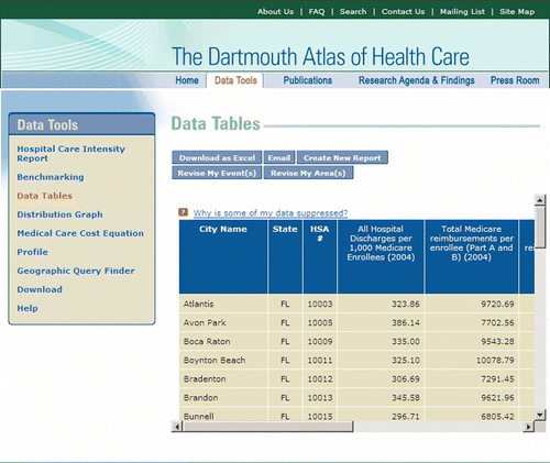
We touch on the hypothetical to envision how mapping and GIS could be learning tools that support general education courses. At Harvard, its ‘United States’ requirement can be filled by a class entitled ‘Medicine and Society in America’ (Harvard University, Citation2008). In such a course, students could spend time with the geographically based Dartmouth Atlas of Health Care (http://www.dartmouthatlas.org) and see how numerous medical care and related expense variables differ across and within States (Figure ). This site also provides ESRI's shapefiles for download if students wanted to map the data themselves, enabling further evaluation of how socioeconomic and demographic variables interplay. They can learn how geography and population distribution determine hospital service areas (HSAs) and hospital referral areas (HRAs), and understand the implication of those areas on health care nationally.
Figure 1 Sample of ready-to-map tabular data available from Dartmouth's Healthcare Atlas (http://www.dartmouthatlas.org). This site also provides shapefiles of mapping areas (such as Health Service Areas, HSAs) to join with data for more extensive GIS analyses.
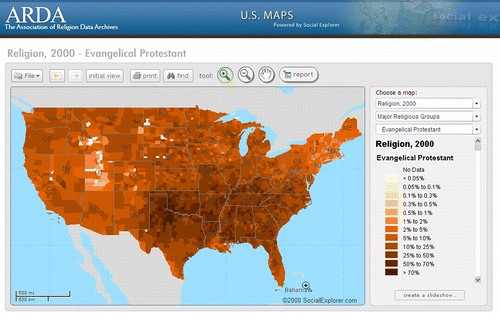
Harvard's ‘Culture and Belief’ requirement can be satisfied with a class entitled ‘Reason and Faith in the West’, during which they could evaluate patterns of religious data made available at the Association of Religion Data Archives (http://www.thearda.com). This organization maintains decades worth of survey data regarding membership from dozens of religious denominations (Figure ). These data can also be downloaded for use with GIS software, and students can delve deeper into the patterns that will appear. Richer analyses may only occur when students consider these through GIS and begin to ask questions across multiple data sets.
Figure 2 Example of online maps available through The Association of Religion Data Archives (http://www.thearda.com). Raw data are also available for download to be used wihin GIS for more extensive GIS analyses.
Harvard's undergraduate population may also find that their courses have more of an ‘activity-based’ component. Activities outside the classroom—internships, community-based work, civic-minded projects, service learning—could readily involve mapping and GIS, and again expose students to spatial perspectives. Increased exposure develops awareness, awareness cultivates curiosity and curiosity engages learning.
In practice, few non-geography faculty are likely to be prepared to pose spatially or geographically based questions of their curricula, when the spatial or geographic perspective is not one they are accustomed to exploring (Kerski, Citation2003; Bednarz, 2005). Students may visualize varying patterns of data across space, but may not be taught why those occur or what drives the patterns. This could be treated as an insurmountable barrier to spreading geography, or as an opportunity for the staff at Harvard's CGA to help its own faculty and undergraduate students. As an example, geographers on staff at Tufts University's GIS Center (http://uit.tufts.edu/at/gis/) regularly consult with faculty on their mapping and GIS-related questions.
A Case Study from Redlands, California
The University of Redlands is a small, private, liberal arts institution with a primary focus on undergraduate education, coupled with graduate schools of education and business. In 1998 Redlands embarked on a long-term initiative to develop GIS-based expertise and capacity in its operations, research and curriculum. The university founded the research-focused Redlands Institute and an applied master's degree programme in GIS, investing in computing infrastructure, support staff and faculty. Redlands also convened a senior leadership group to plan strategically for the infusion of spatial thinking across campus. Over time these investments generated commitments among undergraduate faculty to integrate spatial approaches in their research and teaching.
To further this initiative, the university created a new academic position in 2007, hiring me as Director of Spatial Curriculum and Research to coordinate course development and faculty research. We are pioneering courses and projects in conjunction with faculty from music, biology, religion, race and ethnic studies, environmental studies, government, anthropology, education and archaeology. Each of these projects or courses focuses on the where within each respective discipline, whether that focus is on landscapes, narrative texts or social networks, to gain new insights into why, how and when.
Apart from these courses, some of which fulfil general education requirements, GIS is regularly linked with activities that the university is pursuing as part of its strategic plan. For example, we have long been involved in conversations about how our region of Southern California—the Inland Empire—can become a ‘sustainable community’. Supported by a grant from the Small Business Administration, we are generating a Business Atlas for the Inland Empire that will provide data, case studies and geographically based economic insights for our region.
GIS figures prominently in the activities within our LENS (Learning Spatially) Initiative. We share our small Californian city with ESRI's headquarters and we have always had their encouragement and support. But from its start LENS has promoted spatial thinking and reasoning as its focus, using GIS as only one of many tools for spatial analysis and understanding. In the fall of 2008 I offered a First Year Seminar for incoming students that piloted a new curriculum on spatial thinking and explored the study of spatial concepts both separate from and in the context of numerous academic disciplines. At Redlands, not only is it possible to find individual general education courses featuring maps and GIS, but we have even entertained the thought of pursuing a whole general education category in spatial thinking.
What Can Happen Elsewhere and What Will That Entail?
There is no one-size-fits-all role for GIS within higher education, and that speaks to the versatility of geospatial technologies and the breadth of applications for spatial analyses. Programmes can focus on graduate degrees, such as the new PhD programme in Spatially Integrated Social Science at the University of Toledo (Ohio) or take on a campus-wide agenda, such as University of California at Santa Barbara's spatial@ucsb initiative. For several years, NITLE (the National Institute for Technology and Liberal Education) has offered mapping and GIS workshops for faculty and staff at its 100+ colleges and universities, to offer support and inspiration to institutions that may have limited capacity to support GIS interest otherwise.
As GIS use rapidly expands, institutions are confronted with questions about its place and management (Cady et al., Citation2008). Maintaining and supporting GIS can be complex and costly. Certain conditions and expectations may need to change for greater acceptance and implementation of its use (National Research Council, 2006). Individual professors who have made the leap to teaching with GIS often describe the experience as both vastly rewarding and overwhelmingly frustrating. Initiating a GIS-based research project or adapting existing curriculum to contain a GIS component takes time, our most precious and scarce resource (O'Dell, Citation2006). Mastering new intellectual and technological skills takes considerable effort as well, and visualizing geographic information without the distractions of digital technologies can be tempting and effective (Knowles, Citation2000). Most importantly, developing meaningful and substantive connections between the data in the machine and student learning cannot always be orchestrated and is rarely spontaneous. Greater rewards typically come through more extensive efforts and thus require more planning and expertise on the part of the faculty and perhaps available academic support staff.
The relationship between mapping, GIS and geography is poorly understood outside the discipline, and appreciating the perspectives of non-geographers can provide insight. Though GIScience is just one geographical subfield, and perhaps the majority of geographers have little or nothing to do with GIS, the use of maps and mapping is one of our defining characteristics. Some non-geographers perceive GIS to be wholly and exclusively within the domain of geography (“GIS? Isn't that something they use over in the geography department?”). Others, meanwhile, may not recognize that a disciplinary connection exists (“I saw this really great presentation at my history [economics, biology, etc.] conference where they were using a mapping program to …”) and many perceive ‘mapping’ and ‘GIS’ to be wholly overlapping activities and terms.
Differentiating between mapping and GIS requires an understanding of technologies and approaches that is uncommon among non-geographers. Often their ‘mapping’ needs are relatively simple. They may have tabular data representing quantities of some value for some places and wish to show the variability across space (as a thematic choropleth or dot density map would do). Or they have a list of locations with attributes or descriptions and merely want to place points on a map. Without an awareness of alternatives, they typically turn to GIS software—arguably a mismatched tool for those particular mapping objectives. Many use an ‘industrial strength’ suite of software tools to generate simple one- or two-layer maps, with little evidence of any spatial analysis having been applied whatsoever (O'Kelly, Citation2000). Overall we have been slow to develop simple mapping alternatives, though recently emerging web-based technologies, such as GeoCommons and applications that generate map mashups, are welcome additions to the toolbox.
Regardless of their chosen tool, as more people begin making maps some bad maps will be made. Cartographic standards are ignored, modifiable areal unit problems are disregarded and projections become optional (Hallisey, Citation2005). (Bad) digital cartography becomes the sole product, and the potential for any robust and interesting spatial analysis is overlooked. To some, this ‘misuse’ of mapping and GIS is an affront to the discipline as a whole, and represents yet another opportunity for geographers to be defensive about their identities. Wide-ranging GIS usage has not been well received by all in our discipline, and precious few maintain a sense of humour about it (McNoleg, Citation1988). As past AAG President Kavita Pandit noted, “As geographers we are often very sensitive when non-geographers receive attention for what we view as purely geographic research. The underlying fear, of course, is that if others start working with geographic concepts and ideas, we will somehow be rendered irrelevant” (Pandit, Citation2006).
While we discuss and debate, mapping and GIS use continues to grow, with little regard or concern for how academic geography feels about it. Neogeography, “people using and creating their own maps, on their own terms and by combining elements of an existing toolset” (Turner, Citation2006) is spawning its own conferences, publications and hundreds of websites. Not only are faculty far and wide beginning to experiment in small bits of teaching with maps and GIS, but we also know that dozens of non-geography faculty are now teaching about maps and GIS (in full semester-long, credit-bearing courses) (O'Dell, Citation2006). Many have become voracious consumers of both traditional GIS and of web-based mapping applications, and some of the most innovative and creative mapping and GIS applications, in academe and otherwise, have emerged from these and other non-traditional venues (Longley, Citation2000; Sinton & Lund, Citation2006).
Rather than geographers worrying about how GIS is being used by others, we ourselves could be studying this use. Mapping and analytical ‘mistakes’ become teaching opportunities. We should welcome requests from editors of non-geography journals to review articles involving spatial analyses. “[I]t is in this use of GIS as a tool for spatial analysis in the digital age that geographers are likely to demonstrate their worthiness in terms of cumulative academic activity” (Longley, Citation2000, p. 40). We can introduce people to multiple and varied approaches to spatial statistical analyses (Fotheringham & Brunsdon, Citation2004). We have no control over the popularity of GIS, and we can use that popularity in a way that benefits geography overall (Murphy, Citation2003; Goodchild, Citation2006).
Instead of viewing mapping software as threatening to the profession, cartographers should realize that it might lead to an increased general understanding of how maps and map displays function as both devices for communicating knowledge about geographic phenomena and as tools for exploring these phenomena. (Hallisey, Citation2005, p. 359)
Concluding Thoughts
New areas of geography-related activity include: the hiring of individual geographers into non-geography departments; the growth of GIS centres at many universities; a rise in the number of GIS courses being taught by geographers and non-geographers alike; and an ever-growing increase in small-scale teaching with GIS examples. When these are associated with other activities and curricula that institutions support and offer—such as general education courses, community service projects and undergraduate research—we increase the likelihood that students will experience the powerful insights that spatial analyses and geographical perspectives can provide. This infusion approach engages students directly through their coursework and extra-curricular activities, representing tangible and meaningful models for how spatial perspectives are directly relevant and important in education.
Acknowledgements
This paper has developed over a number of years and numerous discussions with fellow educators including S. Bednarz, J. Kerski, J. Rivera, J. Krygier, C. Drennon, J. Lund, J. Caris, P. Nyhus, T. Mayer, A. Knowles, D. Janelle and M. Goodchild. The author thanks them for their ideas and encouragement. She also appreciates the comments from several anonymous reviewers.
Related Research Data
References
- American Association of Colleges and Universities (2004) Liberal Education Outcomes. Association of American College and Universities. Available at http://www.aacu.org/advocacy/pdfs/LEAP_Report_FINAL.pdf (accessed January 2009).
- Anselin , L. , Syabri , I. and Kho , Y. 2005 . GeoDa: an introduction to spatial data analysis . Geographical Analysis , 38 ( 1 ) : 5 – 22 .
- Bednarz , S. 2005 . Geographic information systems: a tool to support geography and environmental education? . GeoJournal , 60 : 191 – 199 .
- Bednarz , R. S. and Bednarz , S. W. 2004 . Geography education: the glass is half-full and it's getting fuller . Professional Geographer , 56 ( 1 ) : 22 – 27 .
- Bjelland , M. 2004 . A place for geography in the liberal arts? . Professional Geographer , 56 ( 3 ) : 326 – 336 .
- Cady , C. W. , Walters , H. , Olsen , W. , Williams-Bergen , E. and Harloe , B. 2008 . Geographic information services in the undergraduate college: organizational models and alternatives . Cartographica , 43 ( 4 ) : 239 – 255 .
- CUR Quarterly . 2007 . GIS across the curriculum: special focus on GIS applications . Council on Undergraduate Research Quarterly , 27 3, March 2007)
- Drennon , C. 2005 . Teaching geographic information systems in a problem-based learning environment . Journal of Geography in Higher Education , 29 ( 3 ) : 385 – 402 .
- Fotheringham , A. S. and Brunsdon , C. 2004 . Some thoughts on inference in the analysis of spatial data, International . Journal of Geographical Information Science , 18 ( 5 ) : 447 – 457 .
- Gewin , V. 2004 . Mapping opportunities . Nature , 427 : 376 – 377 .
- Goodchild , M. F. 2006 . GIScience ten years after Ground Truth . Transactions in GIS , 10 ( 5 ) : 687 – 692 .
- Hallisey , E. 2005 . Cartographic visualization: an assessment and epistemological review . Professional Geographer , 57 ( 3 ) : 350 – 364 .
- Harvard Gazette Archives (2006) Geography center launched. Available at http://www.news.harvard.edu/gazette/2006/05.11/05-geography.html (accessed January 2009).
- Harvard University (2007) Final Report of the Task Force on General Education, February 2007. Available at http://www.fas.harvard.edu/∼secfas/General_Education_Final_Report.pdf (accessed January 2009).
- Harvard University (2008) Program in General Education. Available at http://www.generaleducaiton.fas.harvard.edu (accessed January 2009).
- Harvard University Gazette Online (2007) FAS approves new General Education curriculum. Available at http://www.news.harvard.edu/gazette/2007/05.17/01-gened.html (accessed January 2009).
- Kerski , J. J. 2003 . The implementation and effectiveness of geographic information systems technology in secondary education . Journal of Geography , 102 ( 3 ) : 128 – 137 .
- Knowles , A. K. 2000 . A case for teaching geographic visualization without GIS . Cartographic Perspectives , 36 : 24 – 37 .
- LaGesse, D. (2008) 50 ways to improve your life: ‘Geotag’ your digital pictures. Available at http://www.usnews.com/articles/news/50-ways-improve-your-life/2008/12/18/geotag-your-digital-pictures.html (accessed January 2009).
- Longley , P. A. 2000 . The academic success of GIS in geography: problems and prospects . Journal of Geographical Systems , 2 : 37 – 42 .
- McNoleg , O. 1998 . Guest Editorial: Professor Oleg McNoleg's guide to the successful use of geographical information systems (ten ways to say nothing with GIS) . International Journal of Geographical Information Science , 12 ( 5 ) : 429 – 430 .
- Murphy , A. 2003 . President's Column: Geography and a liberal education . AAG Newsletter , 39 ( 5 ) : 3
- Murphy , A. 2007 . Geography's place in higher education in the United States . Journal of Geography in Higher Education , 31 ( 1 ) : 121 – 141 .
- National Research Council . 2006 . Learning to Think Spatially: GIS as a Support System in the K–12 Curriculum , Washington, DC : National Academies Press .
- O'Dell, S. (2006) Geographic information systems (GIS). Support at the college level. Presentation at the Annual Conference of the American Library Association, New Orleans, Louisiana, June.
- O'Kelly , M. E. 2000 . GIS and educational and instructional challenges . Journal of Geographical Systems , 2 : 23 – 29 .
- Olson , D. and Bialystok , E. 1983 . Spatial Cognition , Hillsdale, NJ : Lawrence Erlbaum .
- Pandit , K. 2006 . President's Column: Stepping into the future . AAG Newsletter , 41 ( 10 ) : 3
- Sinton , D. and Lund , J. 2006 . Understanding Place: GIS and Mapping Across the Curriculum , Redlands, CA : ESRI Press .
- Sui , D. Z. 1995 . A pedagogic framework to link GIS to the intellectual core of geography . Journal of Geography , 94 : 578 – 591 .
- Turner , A. 2006 . Introduction to Neogeography , Sebastopol, CA : O'Reilly Publications . Available at http://oreilly.com/catalog/9780596529956/ (accessed January 2009)