
Abstract
The massive open online course (MOOC) is a new approach for teaching online. MOOCs stand apart from traditional online classes in that they support thousands of learners through content and assessment mechanisms that can scale. A reason for their size is that MOOCs are free for anyone to take. Here we describe the design, development, and teaching of a MOOC called Maps and the Geospatial Revolution. We explore the geography of the student population, the experience of teaching a MOOC, and evaluate its impacts on learning. We conclude with several key challenges and opportunities we see for MOOCs in geography.
Introduction
Recent years have seen the rise of a new model for distance learning: the massive open online course (MOOC). MOOCs are unique compared to other models of distance learning because they are designed to scale educational experiences to tens of thousands of students around the world at one time. MOOCs feature delivery methods and assessments that are built from the assumption that instructors alone cannot individually interact with each student at that scale. As a result, MOOCs require students to rely on each other for assistance, and MOOC instructors have comparatively fewer tools with which to shape their course experiences than would be common in online courses that enroll dozens rather than thousands of students. Champions of MOOCs argue that such scalable courses help answer a critical need for improved global access to higher education, and that they can help drive down the rising cost of higher education when used to augment traditional institutional curricula (Pappano, Citation2012). Critics of MOOCs point out that very small percentages of students actually complete most MOOCs, that their pedagogical model leaves much to be desired when compared to educational experiences that allow for close interaction between instructors and students, and that they are largely taken by students who are already highly educated (Emanuel, Citation2013). Therefore, MOOCs have not significantly impacted educational shortfalls or gaps.
Here we report on the design, development, and teaching of what we believe to be the first MOOC on a topic in geography. The class, titled Maps and the Geospatial Revolution, was designed to provide an introduction to the mapping sciences for a novice audience.
Our work contributes insights from designing, developing, and teaching a MOOC in geography. We highlight the differences between MOOCs and more traditional forms of distance learning in geography and explore the results gathered from assessment and interaction data. Challenges for evolving the MOOC model and incorporating it into existing geography curricula are described, as well as opportunities for using the unique affordances of MOOCs to enhance geography outreach and research on geographic education.
Distance learning and the emergence of MOOCs in geographic education
Early efforts to develop online distance education options in geography were inspired in part by GIScience scholars convened by the National Center for Geographic Information and Analysis in the late 1990s. Their interest in expanding the reach of GIScience education came from a focus on improving interoperability in geographic information systems (GIS). As the notion of a fully interoperable geospatial future evolved, so too did the concept of an expanded educational footprint for GIScience where cross-cutting spatial thinking and analytical concepts could be taught to the broader public expected to engage with GIS tools and technologies (Kemp, Reeve, & Heywood, Citation1999).
Meeting the needs of this expanded audience of GIScience learners inspired a radical rethinking of methods for educational engagement. The emerging priority to support interoperability through expanded GIScience education coincided with a surge in widespread interest among educators to explore options for digitally-supported and online learning, often called e-learning (Garrison, Citation2011). An early focus for digital learning in geography was to support adult learners who were seeking professional development. As geospatial technology employment opportunities expanded from the late 1990s onward, geography educators devised e-learning programs to engage aspiring geospatial professionals and to provide lifelong learning opportunities for those who already had substantial prior experience. Distance education options offer clear value for reaching these new audiences, as few working professionals can attend same-time, same-place courses, and many are located far away from a suitable college or university (Solem, Chalmers, DiBiase, Donert, & Hardwick, Citation2006).
Today, distance education in geography includes a wide range of possibilities, including blended and fully online models, and methods of engagement that include synchronous as well as asynchronous approaches (Unwin, Tate, Foote, & DiBiase, Citation2011). A great deal of work has focused on establishing best practices for online learning in geography (Clark, Monk, & Yool, Citation2007; Terry & Poole, Citation2012), and evidence from a wide range of studies has now confirmed that properly-designed online courses are at least as good as their resident counterparts, and quite often they offer important advantages to learners in terms of flexibility and providing alternative forms of access to suit a diverse range of learning styles (Means, Toyama, Murphy, Bakia, & Jones, Citation2010).
What began with individual online geography courses during the late 1990s has now evolved to include full programs of study that can be completed at a distance. The subfield of geography with the most examples of such programs is GIScience, where there are now dozens of options for students to pursue degrees and certificates at a distance (McMaster, McMaster, Manson, & Skaggs, Citation2007). Online courses in these programs use a wide range of models, including synchronous and asynchronous designs, and feature content delivery through course texts, lecture videos, discussion tools, and virtual laboratories (Unwin et al., Citation2011). Class cohorts are sometimes larger in online courses—particularly those that use blended-learning approaches, but until recently there has not been much progress toward scaling online courses for significantly larger audiences (DiBiase & Rademacher, Citation2005).
In 2008, George Siemens and Stephen Downes of the University of Manitoba launched the online course “Connectivism and Connective Knowledge,” which first enrolled 25 students paying tuition, was subsequently opened up for anyone to participate at no cost, and eventually drew in a further 2300 students from around the world. This course is widely credited as being the first MOOC (McAuley, Stewart, Siemens, & Cormier, Citation2010). Other examples soon followed, along with the development of new technology platforms to deliver MOOCs, such as Coursera, launched by Andrew Ng and Daphne Koller from Stanford University, Udacity, led by Sebastian Thrun from Stanford University, and edX, a platform co-developed by the Massachusetts Institute of Technology and Harvard University. Classes offered through these new platforms have proven to be very popular, with courses routinely enrolling tens of thousands of students from around the world. What made MOOCs different from traditional online courses was the combination of free access, scalable content delivery, and scalable assessment methods.
Today, educators and their administrators face unprecedented pressure to improve access to higher education, to become more efficient in the practice of teaching, and to encourage learners to experiment and engage with new topics through the use of new technologies. Those who champion MOOCs highlight their potential to provide solutions to these problems, while MOOC critics focus on the lack of coherent revenue models, poor retention rates, and serious pedagogical concerns associated with the inability for an instructor to provide individualized instruction to thousands of students.
In early 2013, Penn State formally joined Coursera, one of the largest current MOOC technology platforms, with over seven million users at present. In late 2012, discussions at Penn State began among a group of distance educators, including the first author, regarding the slate of MOOC offerings that would kick off Penn State's involvement with Coursera. These discussions provided the opportunity for us to propose a MOOC focused on the basics of mapping and geospatial science. Our interest in MOOCs is to experiment with this approach to learning in the context of geography and to identify key challenges and opportunities for MOOCs in our field. Maps and the Geospatial Revolution was announced and opened for enrollment on Coursera on 20 February 2013, with a class start date of 17 July 2013. To our knowledge the Maps MOOC was the first geography MOOC to be opened for enrollment on any platform. In the months after our course was announced, several other geography MOOCs were launched, including Geospatial Technology for STEMx Learning offered on HP's Catalyst Academy site by Del Mar College and Texas A&M University – Corpus Christi (Schutzberg, Citation2013c), Mapping with Google offered through Google's Course Builder platform (Schutzberg, Citation2013a), and GIS Basics from Pace University through Blackboard's CourseSites platform (Schutzberg, Citation2013b).
Course design
Competencies and expected outcomes
To develop this course, we began by reviewing the core competencies described by the GIS&T Body of Knowledge (GIS&T BoK) (DiBiase et al., Citation2007) and the U.S. Department of Labor Geospatial Technology Competency Model (GTCM) (DiBiase et al., Citation2010). Both resources provide broad-reaching definitions for core competencies that constitute relevant learning objectives for a class taught on GIScience. We developed a synthesized list from these two resources to outline a large set of possible learning objectives, and then iteratively developed an outline for the course we wanted to teach by choosing which competencies we would cover. In addition, for those concepts we did want to teach, we assigned a basic qualitative rating to indicate the depth to which we wanted to explore each area. Ultimately, we relied most heavily on the GTCM Tier 2 and Tier 5 competencies, as these seemed to best fit our overall goals for the depth at which we sought to reach with our content.
Next we used this list of possible learning objectives to build an outline for the class, assigning objectives to at least one lesson (and in some cases to multiple lessons). This outline served as the basic structure to follow for the remainder of our content development. The resulting outline can be reviewed in the online Supplementary material, where we have listed content areas and competencies covered for each lesson. Objectively rating the depth to which we tackle each area is not an effort we attempt to undertake here, though we hope to investigate this in future research.
Course structure
The course was designed around the basic objective to teach a geography MOOC that closely approximates a one-credit introductory course at Penn State. At Penn State, each credit hour requires 40 hours of student engagement. With this general guideline in mind, we determined that a five-week course which featured eight hours of student engagement in reading, watching lectures, making maps, and participating in discussion would be the right target length. In addition to our objective to teach an introductory course to novices, we were also aware of guidance from Coursera that short courses (five to eight weeks duration) are more likely to retain students than longer courses.
Course content
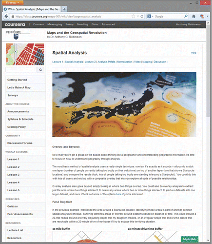
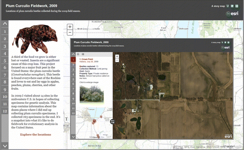
The content for this class was organized into five lessons, one provided for each of the five weeks in the course in a paced format. Each lesson began with the development of written and graphical content to teach the core course objectives (Figure ). This content was augmented by hands-on mapping assignments developed using Esri ArcGIS Online web mapping tools, weekly discussion assignments, video presentations from the PBS WPSU Geospatial Revolution documentary series, and short video lectures to add context to the core written and graphical content.
This class, unlike most MOOCs, was not designed to feature lengthy lecture videos as the primary means for learning. Coursera's guide for new course developers places heavy emphasis on the development and delivery of video lectures as the primary method for distance education, and their default interface for student interaction is a list of lectures, accompanied by lecture notes. However, long lecture videos introduce access issues for global students with poor Internet access, and effective distance education requires far more than the simple presentation of classroom lectures in a web-accessible format (Horton, Citation2011). Moreover, distance education in geography typically involves a richer type of course design to include online texts, discussion activities, wikis, tutorials, and peer assignments (Unwin et al., Citation2011). Therefore, while we were not required to create lecture videos, we produced two short videos (8–10 minutes each) for each of the five lessons to provide additional context beyond the core course material, though students in our MOOC could complete all assessments successfully without having watched these videos.
Assessments
MOOC assessment must rely on either automated means of grading or peer assessment mechanisms, as the number of students who participate is too large for an instructor to grade with manual methods. In the Maps MOOC, we used weekly multiple-choice quizzes, discussion participation, a peer-evaluated map design project, and a cumulative final exam to evaluate learners. The weekly quizzes featured concepts delivered in the written content and lectures, and they also included questions that required students to complete the mapping assignments. The latter focus was necessary because there is currently no way to develop automated assessments that could evaluate student work in ArcGIS Online and transmit those results to the Coursera platform. We allowed students to take each quiz up to three times, and quizzes were not timed. This design choice is modeled after principles of mastery learning (Block & Burns, Citation1976), which focus assessments on students competing against their own personal best efforts rather than each other.
Weekly discussion prompts were developed to encourage students to engage in conversation around the impacts of geospatial technology and practice on society and the environment. Discussion participation can only be evaluated in Coursera by counting the number of posts a student makes, and while this metric is not a robust measure of engagement, we decided that encouraging participation in discussion assignments still had substantial value. Students were asked to post 20 times during the course to receive full credit.
Peer assessment is commonly used in MOOCs to provide students with individualized feedback on open-ended assignments. In the Maps MOOC, we used peer assessment for a final map design project intended to synthesize learning objectives from the entire course into a self-directed project. This final assignment asked students to develop a map to tell a story about geographic data of their choice using either the ArcGIS Online tools they had gained experience with in the weekly laboratory assignments, or through other mapping tools that they felt comfortable using (e.g., QGIS, ArcGIS Desktop, MapBox). The rubric for this assignment asked students to evaluate submissions in terms of their completeness, the extent to which they told a compelling story, and to what extent the map embodied best practices in cartographic design. Peer assessment tools in Coursera allow students to review this rubric prior to developing their submissions, and all students review their own work using this rubric before reviewing other randomly chosen submissions. Instructors in a Coursera MOOC can set the number of required reviews, and students can choose to review more submissions on a voluntary basis. For this assignment, we asked students to review three of their peers.
The final assessment in the Maps MOOC was a cumulative exam. That exam included topics from all five of the weekly lessons. This was the only assessment that was limited to a single submission and timed; students had two hours to complete the 50-question exam. Our design choices here reflected our desire to understand the extent to which students had actually mastered the concepts by the end of the course. By providing only one attempt and timing the session, we reasoned that students would be less able to manually look up every answer from previous lessons.
Development and delivery
The initial work to develop a full course syllabus and refined set of learning objectives occurred in February 2013. Written and graphical course content was developed in March and April 2013, and video lectures were shot and edited in May 2013. Laboratory assignments were also finalized in May. The full course was prepared by early June, providing several weeks to conduct internal testing and review prior to the launch of the class on 17 July 2013.
A recent review of 29 institutions offering MOOCs found that their development costs can be extremely high and require thousands of hours of effort from faculty, learning design staff, and media professionals (Hollands & Tirthali, Citation2014). Our example shows that a MOOC can be created without resources beyond the ordinary. The course required approximately six months of half-time effort from the lead instructor, as well as a quarter-time effort for that same period from a learning designer. Additional hourly support for video editing was necessary, although the instructor shot the raw footage himself. Significant assistance in developing laboratory assignments came from Joseph Kerski, Angela Lee, and David DiBiase from the Education Team at Esri. This project team and time commitment are comparable to what we would normally allocate for any online course development project in our Online Geospatial Education programs at Penn State.
Demography and geography of MOOC students
Coursera provided self-reported demographic data for 7551 of the students enrolled in our class (Table ). Respondents were not required to select an answer for each question, so in some cases the totals we report do not add to 100%. These data reveal a class with significantly more males (69.4%) than females, even compared to the Coursera average across all MOOCs. We can also see that a slightly higher proportion of students in the Maps MOOC live in the USA (30.4%), compared to a Coursera average. The mean age of our students from this sample is 36.5, which is very close to the Coursera average. No further detail is provided by Coursera to reveal the range of age groups who enrolled in the class.
Table 1 Student demographic data from the Coursera pre-course survey.
Student self-reported educational and professional backgrounds are also available. More students in the Maps MOOC held a Master's degree (39.1%) than Bachelor's degree (33.8%), and 8% stated they have earned a Ph.D., with the remaining 14.7% having completed some college credits, high school, or a professional degree program. Most respondents say they are not currently enrolled in an educational program, while 20.9% are enrolled in a graduate program and 14.2% are enrolled in an undergraduate program. Employment data suggest that over half are working full time and that the next largest group is of those who are unemployed (18.6%). The top industry classifications for employed students are also shown in Table . The largest group includes computer and mathematical science, followed by education, architecture/engineering, and business sectors. A wide range of other categories make up the remainder of the population.
To supplement the basic demographic data provided by Coursera, we used a simple mapping activity at the beginning of the course to collect students' self-reported locations, age groups, and genders. We created a web map which allowed students to add pins to their home locations and provide responses to age and gender questions, as well as the option to provide a brief statement regarding how they use maps. This web map, hosted on Esri's ArcGIS Online, collected 22,781 submissions from students enrolled in the class (Figure ).
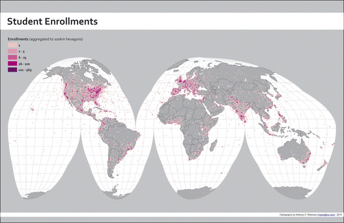
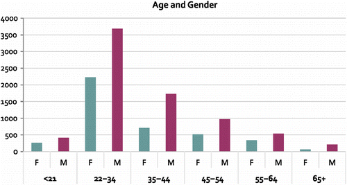
Participation in this activity was voluntary, and we did not require answers to each question. Therefore, the data-set has gaps where students chose not to provide answers for some fields. A total of 11,764 responses included valid entries for each of the three questions. Using only these responses, we find 4139 females (35.3%) and 7571 males (64.7%), which pushes the course demographic closer to the Coursera average than the Coursera survey results suggested. Analysis of the age distribution from these responses (Figure ) shows that over 50% of the course is age 34 or younger, and more than 75% of the course is 44 or younger.
In addition to the global distribution of students shown on the map in Figure , the geography of enrollments in the Maps MOOC can also be explored by totaling the enrollments by country. The top 10 countries are shown in Table . In addition, analysis of the Internet Protocol addresses logged from the Maps MOOC user database in Coursera revealed a total of 177 countries participating in the course.
Teaching the course
The Maps MOOC opened for students on 17 July 2013. From that date onward, new lessons were opened each Wednesday for the five-week duration of the class. Because the course content was fully prepared in advance of starting the class, the weekly roll-out of new lessons was relatively simple and only required the unmasking of hidden content pages. During the class session, we engaged with students for two primary purposes: we monitored reports from students regarding problems they had with the course content and assessments, and we discussed the science of mapping and related topics.
Active engagement required frequent manual monitoring of the discussion forums. The lead instructor spent an average of two hours every day (including weekends) scanning the forums to identify and fix problems where necessary. Error correction and content editing were handled on an ongoing basis to improve the course experience. Hourly help from a paid course assistant was added after the first two weeks to triage potential technical and course material issues to allow the lead instructor to interact with students on the content itself.
Although a constraint of MOOCs is the inability for instructors to engage directly with all students, we found that it is quite possible, given substantial effort, to engage with many students through active forum participation. The lead instructor spent an additional two or more hours each day posting replies to discussion threads about the course content and related topics. To help encourage student engagement, the lead instructor also created weekly digests to highlight approximately 20 discussion threads that were particularly good examples of thoughtful interaction. To further encourage interaction, we created a special forum during the third week of the course called Ask Me Anything, borrowing a popular discussion generation concept from Reddit. In this special forum we asked students to submit questions and vote their favorites to the top using Coursera's forum post upvoting/downvoting features. At a specific time, the lead instructor then answered as many of the top questions as possible during a three-hour session. The Ask Me Anything forum activity generated over 400 discussion threads on its own in just a few days. In total, the lead instructor posted 979 times to the forums during the course, including answers to over 50 questions posed in the Ask Me Anything forum.
While direct email contact from individual students was discouraged by Coursera, the instructor nonetheless received and responded to over 300 emails from students before, during, and after the class. After the class began, direct email traffic decreased, perhaps due to specific guidance given once class began regarding best practices for communication in a MOOC.
Assessment results
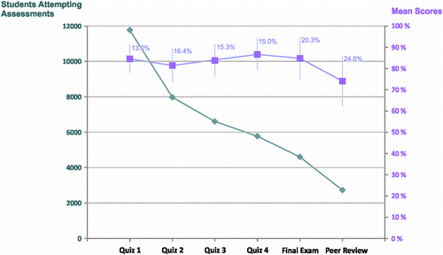
As indicated in earlier sections, we deployed several types of assessments to evaluate student achievement in the Maps MOOC. These methods included weekly quizzes using multiple choice questions, a comprehensive final exam, a peer-assessed final map design project, and class discussion participation. Figure shows the number of students participating in quiz, exam, and peer review assessments, as well as mean scores bounded by one standard deviation to show the variability in scores. All scores were normalized into percentages to account for variability in the number of questions and points used in each form of assessment. Discussion assignment participation can only be evaluated by measuring the presence or absence of participation, not its quality; therefore, we do not include grading results for that element in this graphical representation. A total of 12,474 students participated in discussion in the class.
Peer assessment in MOOCs is frequently used to offer qualitative and quantitative feedback at scale to individual MOOC participants. For MOOC projects that require assessment beyond what can be graded electronically, peer assessment provides a means for evaluation that scales to the size of the cohort. Students in the Maps MOOC were asked to create a final map project to tell a story about data they found or created themselves. Students submitted either a URL to a web map, PDF, or another graphic file for rating by three of their peers, using the previously described rubric. In the Maps MOOC, 2736 student submissions were collected for this final assignment, and students rated each other's work 12,815 times (many students choosing to rate more than the required three peer examples).
This assessment activity was the most difficult to explain to students, as few had prior experience with peer evaluation, and some openly expressed doubts that it was a viable method for assessment. Coursera's interface and tools for peer evaluation were not optimally designed, resulting in a sizable number of students incorrectly posting their work in the forums rather than in the dedicated peer evaluation interface. We do not know exactly how many students this affected, but based on forum discussions and email correspondence with students, we believe the number included several hundred students.
In this MOOC we found that peer grading results show that student ratings generally agreed with one another (0.64 correlation using Average Measures Intraclass Correlation). As part of ongoing research into the use of peer assessment to grade map designs (Luo, Robinson, and Park, Citation2014), the lead instructor has manually graded a 5% sample of the submitted assignments to compare expert grading to student grading. Our preliminary results show that expert grading is significantly correlated to student grading (r = 0.619, p < 0.01, using Pearson's Correlation Coefficient).
The maps produced through the final assignment were diverse and impressive, using a wide range of mapping platforms, including ArcGIS Online, QGIS, MapBox, Esri's Story Maps, and a host of other solutions. While many submissions were very simple maps, we also saw examples shared in the forums that demonstrated significant levels of competency and achievement in such a short course (Figure ).
Outcomes
Much is made of the overall completion rate for students in MOOCs. This is typically defined by the proportion of students who earn a passing grade in a given class. In practice, most MOOCs have shown very low rates of completion by this metric, with courses often falling in the 5–15% range (see http://www.katyjordan.com/MOOCproject.html for a database of MOOC completion rates). Recent work by Ho et al. (Citation2014) analyzing completion rates for more than 800,000 edX MOOC students suggests that a focus on this definition of success is misguided. Their analysis concludes that many students who do not pass courses are accessing substantial amounts of course content, and that free and open online registration is not equivalent to traditional registration models, where monetary and opportunity costs play a significant role.
Using a more conservative view of course completion, 3064 students passed the Maps MOOC, with 1211 earning distinction (grade higher than 90%) and 1853 by standard criteria (grade higher than 70%). This completion corresponds to a rate of 8.4% of the total number of students who were ever active in the class. In considering emerging alternative views of completion, we note that during the final week of the course, there were 8707 active students, corresponding to a rate of 23.9% of those students who began the course in Week 1. This difference between course completion and course activity shows that many students remained engaged through the end of the course, but chose not to undertake formal assessment activities.
Beyond the assessment results reported earlier, course interaction data can help reveal the extent to which students engaged with the course content. Coursera recorded 175,271 views of lecture videos in the Maps MOOC, and a total of 95,945 discussion forum posts were created in 13,030 discussion threads. The resulting discussion forum is more than twice the size of the entire archive of Cartotalk.com, a popular mapping forum that has drawn participants for over 10 years.
Student ratings of course quality and impacts
To further evaluate the quality of our course and explore its impact on those who completed it, we conducted a survey at the conclusion of the five-week class session. Our survey included 20 questions, with 10 focused on quality ratings for various aspects of the course content and its delivery, and 10 questions focused on the ways in which students were impacted by their participation in the class. Over 3300 responses were collected for this survey. Since students were allowed to skip some questions, the total number of responses on each metric varies slightly.
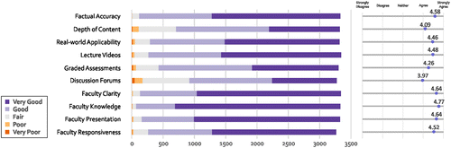
In terms of course content and delivery quality, this MOOC received mostly Good or Very Good ratings for each of the 10 metrics (Figure ). Discussion forums saw the largest number of negative responses (172 in Poor and Very Poor categories, out of 3273 total responses), which we saw echoed in qualitative feedback in the course regarding frustration with the inability to easily navigate the enormous number of forum threads and posts.
While students also rated the course very highly across most of the learning outcome and impact metrics (Figure ), two metrics have a notably larger proportion of lower ratings. In response to the statement “This course motivated me to pursue Geography or a related field by obtaining a Certificate or Degree,” a sizable portion of students disagreed or strongly disagreed (19.6%), while 38.6% were neutral, and 41.6% agreed or strongly agreed. We noticed substantial interest in our course by current geospatial professionals, which may explain why so many students did not agree with this statement. A similar pattern of responses is evident in student responses to the statement, “Students who complete this course should be awarded college credit” included 21.0% who disagreed or strongly disagreed, 35.1% who were neutral, and 43.9% who agreed or strongly agreed. We suspect these ratings may reflect varying student perceptions on the difficulty and rigor of the course.
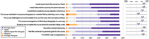
Among the other outcome and impact metrics, we are especially pleased to see high ratings of agreement with statements such as, “This course encouraged me to think about Geography in a new way,” with 81.5% in agreement or strong agreement. This is evidence that we have reached our goal to introduce new audiences to geography.
Challenges and opportunities for MOOCs in geography
In the following sections we build from what we have learned in designing, developing, and teaching our MOOC on Mapping to focus attention on several key challenges and opportunities for future MOOCs in geography, including areas in which we see the potential for future research in geographic education.
Challenges
Identifying leverage points for using MOOCs in geographic education
MOOCs are not poised to replace every other form of distance education, let alone all forms of in-person class experiences. This means that we need to determine what MOOCs can and cannot do in support of geographic education. At present, the types of assessments and content delivery that are possible in MOOC platforms suggest that short, introductory course experiences are likely to be the most successful options. This model also fits well with the fact that MOOC student enrollment is not limited to people with particular pre-requisite knowledge, so controlling a cohort to ensure advanced engagement with a topic is productive is not yet an achievable goal.
In the context of our course on mapping, while many students requested a second course to continue where the first concluded, it is our opinion that the means for assessment and teaching to thousands of students at a distance are not yet sufficient to support higher-order learning competencies. For example, the iterative development and refinement of map designs in a typical upper-division cartography course would not be well supported by the current methods available for assessment and student engagement in MOOCs.
Further investigation is needed to identify when and how MOOCs may be used to positively augment or benefit existing geography curricula. Based on our experience, we see the potential for MOOCs to offer introductory coursework to increase the visibility of geography as an option for prospective students. Student enrollments in our online geospatial education programs at Penn State have increased by more than 25% in the one year since the Maps MOOC was announced, and we are working now to determine how much of this growth was an outcome of the MOOC. In previous years our enrollments have expanded at an average of 5–8% annually.
Characterizing openness in MOOCs on geography
The use of the term Open in describing MOOCs introduces many questions regarding what it means to support openness in geographic education. Openness has been previously approached through free, reusable course content, as seen in open educational resources (OER) offered by universities such as MIT and Penn State (Caswell, Henson, Jensen, & Wiley, Citation2008). Openness in the context of MOOCs typically refers to access to the class experience without paying tuition. The course content is most often not available for re-use for self-study or in other classes as OER have been generally defined. In addition, since most MOOCs are delivered through privately-held platforms such as Coursera, only those who are registered and agree to their terms are able to access the course content, and those terms of use typically prevent others from repurposing the course content. It is also noteworthy that major MOOC platforms now offer opportunities for students to verify their identity in order to receive course certificates that provide more credible evidence of achievement, in exchange for paying a fee. Therefore, it has become true that the Open in MOOCs is already an optional attribute, and even in the best circumstances openness in MOOCs refers only to access to the class through a specific platform at a particular time, not a right to re-use its content.
The geographic dimensions of openness in MOOCs represent a rich research opportunity for geographers. For example, future work could characterize varying models of openness in education to understand the impacts of providing free educational resources (open content) versus providing free educational experiences (open courses). We can also explore and characterize openness in terms of the diverse audiences around the world that may be able (or unable) to access education through MOOCs. While geographers are often focused on higher education at undergraduate and graduate levels among traditional cohorts, there are large populations of adult professionals, retirees, and other audiences that could be reached through MOOCs who we may struggle to reach otherwise.
Shaping future learning platforms to support geographic education
While distance education is not new to geography, it is increasingly common for resident undergraduate degree programs to include online courses or blended courses, which meld in-person and online experiences together (Garrison & Kanuka, Citation2004). MOOCs land clearly in the former category, but their emphasis on scalable types of assessment and content delivery may provide new inspiration for the design of future online learning platforms to support geographic education. MOOC platform providers have been aggressively developing mobile interfaces to their courses, and developing tools for learner analytics that can be used by instructors. These developments augment ongoing work among the major companies who provide more traditional forms of learning management systems in use at most colleges and universities.
Opportunities
Research in geographic science and education
Our students generated an enormous amount of data during the five weeks in which the Maps MOOC took place. In addition to over 95,000 forum posts, 3000 final map projects, and thousands of pre/post-course survey responses, Coursera tracks each student's activities in the course at a very fine level of detail, to include every recordable interface action taken by students while they are logged-in. The full data-set of student interactions includes millions of records and is over eight gigabytes in size. As a result, MOOCs generate what some may call Big Data in the context of geographic education. These data-sets provide the opportunity for us to explore the relationships between learning outcomes and where students live, for example.
In addition, the student population in a MOOC provides a unique recruiting opportunity for external research studies. We experimented with this in our class by recruiting participants from developing countries for interviews to characterize their motivations for taking MOOCs, the results of which we are currently analyzing. Following our announcement in the class, over 150 participants volunteered their time—so many, in fact, that we had to adjust our interviewing strategy to account for a much larger population than we had anticipated. While others have already experimented with crowdsourcing and geospatial research using platforms such as Amazon Mechanical Turk (Klippel et al., Citation2013), a MOOC may offer advantages in that one may be able to recruit participants with stated interests in and motivation to learn a given sub-discipline, such as mapping.
Geography outreach
MOOCs have the clear potential to positively augment geography outreach efforts. At the moment, MOOCs attract large audiences of novices from a broad range of backgrounds around the world. Most of the students in our course were taking a geography class for the first time, and feedback from the post-course survey reveals that many students ended the course with motivation to further their geographic education and that a very large proportion left the class with a better understanding of geography as an area of study. Even if we were to assume that MOOC interest would plateau in the near future, there will still be millions of students engaged with platforms such as Coursera, edX, and Udacity. It is easy to imagine tens of thousands of students engaging with other topics in our field, far beyond the mapping sciences, to include topics in human geography, nature-society, and physical geography. Furthermore, our pre-course survey results suggest that there is sizable interest in our field among educators, an audience whom many of our peers have been trying hard to reach in recent years.
Conclusions
In this paper we have described the design, development, and teaching of the first MOOC on geography. We have also elaborated on some of the key challenges and opportunities we see with MOOCs in geography. Our course attracted tens of thousands of students from around the world, with over 3000 earning a passing grade. In our view, MOOCs show tremendous promise as a mechanism to introduce topics such as geography to a novice audience, and their educational affordances are a reasonable fit for the goals of introductory coursework. We note that our course is only truly possible today due to quite recent advances in the development of powerful, yet usable web mapping tools that work in an Internet browser without requiring any special configuration or extra downloads.
If we reflect on what makes teaching a MOOC distinct from teaching a regular online class, we would conclude that the current assessment and content delivery methods in MOOCs are well suited for learning basic concepts, but may not work well for higher-order learning objectives for all learners. Teaching methods in both MOOCs and regular online courses require heavy workloads, but for different reasons. In a MOOC, small clarity issues with due dates, laboratory instructions, or the wording on a quiz can cause thousands of people to stumble, requiring substantial time for an instructor to address and remedy those issues. In a typical online course that we teach with perhaps 20 graduate students, we spend most of our time engaging on the concepts we are teaching, and in providing individualized feedback on all assignments—two things that cannot yet scale from instructors to students in a MOOC. There is also no mechanism by which one can enforce pre-requisite knowledge, so by default the design of a MOOC has to take into account an impossibly broad set of learner backgrounds and abilities. In regular online teaching, we are able to steer students toward specific courses depending on their prior knowledge, which we can assess through individual conversations, transcripts, portfolio reviews, and pre-tests. Finally, current platforms for offering MOOCs provide a comparatively limited set of delivery and engagement methods, and customizing those platforms is not possible in most instances. In contrast, in our regular online courses we are able to craft very different courses using an ever-expanding range of delivery and engagement methods when scaling to thousands is not required.
As a result, we do not see MOOCs as clear or complete replacements for other forms of distance education, and in fact our experience with the Maps MOOC has helped further confirm our observations from more than a decade of teaching geography online that higher-order conceptual development and deep student–teacher and student-to-student interaction are better supported in small cohorts in traditional online classes.
Despite that observation, we were also pleasantly surprised to see extremely high levels of engagement in the course content and discussions from and between those students who chose to participate with the course from start to finish. This is one area where we note a distinct similarity to our experiences teaching small cohorts in online classes; we expect our students to be highly engaged. Although individual attention to each student from an instructor is in many ways impossible, we also found that high levels of instructor activity were well received by students based on their feedback in the discussion forums and in the post-course survey. It is not true that a MOOC must necessarily be entirely absent of any faculty presence, just as it is also not true that a successful MOOC must only feature lecture videos or be taught by a faculty member who is famous. MOOCs are in a state of constant flux as their platforms and those who teach them constantly redesign their underlying models, assessment methods, and modes of engagement. We believe it is important for geographers to take advantage of their affordances where it is beneficial to do so, and to add to the body of research around education through these means by helping to reveal the spatiotemporal dynamics of MOOC learners and their outcomes.
Supplementary material
Supplementary material of this article is available online.
SUPPLEMENTAL
Download PDF (108.6 KB)Disclosure statement
No potential conflict of interest was reported by the authors.
References
- BlockJ. H., & BurnsR. B. (1976). Mastery learning. Review of Research in Education, 4, 3–49.
- CaswellT., HensonS., JensenM., & WileyD. (2008). Open content and open educational resources: Enabling universal education. The International Review of Research in Open and Distance Learning, 9, 1–11.
- ClarkA. M., MonkJ., & YoolS. R. (2007). GIS pedagogy web-based learning and student achievement. Journal of Geography in Higher Education, 31, 225–239.
- DiBiaseD., CorbinT., FoxT., FrancicaJ., GreenK., JacksonJ., … Van SickleJ. (2010). The new geospatial technology competency model: Bringing workforce needs into focus. URISA Journal, 22, 55–72.
- DiBiaseD., DeMersM., JohnsonA., KempK., Taylor LuckA., PleweB., & WentzE. (2007). Introducing the first edition of the geographic science and technology body of knowledge. Cartography and Geographic Information Science, 34, 113–120.
- DiBiaseD., & RademacherH. J. (2005). Scaling up: Faculty workload, class size, and student satisfaction in a distance learning course on geographic information science. Journal of Geography in Higher Education, 29, 139–158.
- EmanuelE. J. (2013). Online education: MOOCs taken by educated few. Nature, 503, 342.
- GarrisonD. R. (2011). e-Learning in the 21st century: A framework for research and practice. New York, NY: Routledge.
- GarrisonD. R., & KanukaH. (2004). Blended learning: Uncovering its transformative potential in higher education. Internet and Higher Education, 7, 95–105.
- HoA. D., ReichJ., NesterkoS., SeatonD. T., MullaneyT., WaldoJ., & ChuangI. (2014). HarvardX and MITx: The first year of open online courses. Harvardx and MITx Working Paper No. 1.
- HollandsF. M., & TirthaliD. (2014). MOOCs: Expectations and reality (No. 211). Center for Benefit-Cost Studies of Education, Teachers College, Columbia University. Retrieved from http://www.academicpartnerships.com/sites/default/files/MOOCs_Expectations_and_Reality.pdf.
- HortonW. (2011). e-Learning by design. San Francisco, CA: Wiley.
- KempK., ReeveD., & HeywoodD. I. (1999). Interoperability for GIScience education. In A.VČkovski, K.Brassel, and H.-J.Schek (Eds.), Interoperating geographic information systems (Vol. 1580, pp. 101–114). Berlin, Heidelberg: Springer.
- KlippelA., WallgrünJ., YangJ., MasonJ., KimE.-K., & MarkD. (2013). Fundamental cognitive concepts of space (and time): Using cross-linguistic, crowdsourced data to cognitively calibrate modes of overlap. In T.Tenbrink, J.Stell, A.Galton, and Z.Wood (Eds.), Spatial information theory (Vol. 8116, pp. 377–396). Springer International Publishing.
- LuoH., RobinsonA. C., & ParkJ. Y. (2014). Peer grading in a MOOC: Reliability, validity, and perceived effects. Online Learning: Official Journal of the Online Learning Consortium, 18(2), 1–14.
- McAuleyA., StewartB., SiemensG., & CormierD. (2010). The MOOC model for digital practice. Retrieved from http://www.elearnspace.org/Articles/MOOC_Final.pdf.
- McMasterR. B., McMasterS. A., MansonS., & SkaggsR. (2007). Professional GIS education in the United States: Models of access and delivery. In XXIII international cartographic conference (pp. 1–13). Moscow: International Cartographic Association.
- MeansB., ToyamaY., MurphyR., BakiaM., & JonesK. (2010). Evaluation of evidence-based practices in online learning: A meta-analysis and review of online learning studies. U.S. Department of Education, Office of Planning, Evaluation, and Policy Development.
- PappanoL. (2012). The year of the MOOC. The New York Times.
- SchutzbergA. (2013a). Google announces a mapping MOOC: Mapping with Google. In A.Schutzberg (Ed.), All Points Blog. Directions Magazine. Retrieved from http://apb.directionsmag.com/entry/google-announces-a-mapping-mooc-mapping-with-google/332009.
- SchutzbergA. (2013b). Pace university faculty member prepares “GIS 101” MOOC. In A.Schutzberg (Ed.), Directions Magazine. All Points Blog. Directions Magazine. Retrieved from http://www.directionsmag.com/articles/pace-university-faculty-member-prepares-gis-101-mooc/325160.
- SchutzbergA. (2013c). Professional development MOOC on STEMx and geospatial technology coming this summer. In A.Schutzberg (Ed.), All Points Blog. Directions Magazine. Retrieved from http://apb.directionsmag.com/entry/professional-development-mooc-on-stem-and-geospatial-coming-this-summe/324359.
- SolemM., ChalmersL., DiBiaseD., DonertK., & HardwickS. (2006). Internationalizing professional development in geography through distance education. Journal of Geography in Higher Education, 30, 147–160.
- TerryJ. P., & PooleB. (2012). Providing university education in physical geography across the South Pacific Island: Multi-modal course delivery and student grade performance. Journal of Geography in Higher Education, 36, 131–148.
- UnwinD., TateN., FooteK., & DiBiaseD. (2011). Teaching geographic information science and technology in higher education. New York, NY: John Wiley & Sons.