Abstract
This article introduces our project on the relationship between railways and real income levels across European regions between 1870 and 1910. While similar relationships have been analysed for the USA, India and individual European countries, our project is the first to take a pan-European regional perspective. We discuss the reasons for the neglect to date, highlighting the need to drill deeper into the changing directional effects of railways on income, the importance or necessity of using regional-level data and the amount of research that still needs to be done. To this end, we present preliminary insights from our novel database on European regional per capita income and railway mileage, after discussing our data sources in depth. We also outline our research agenda, showing our intended conceptual and analytical approach for future work.
1. Introduction
This article introduces our project on the relationship between railways and real income levels across European regions between 1870 and 1910. We start by discussing the potential economic impacts of railways, moving to a review of the relevant literature. This review suggests methodological approaches to our research, and paves the way for a discussion on what is lacking in European economic history, and how our project will fill these gaps. Detailed discussions and descriptive statistics of our data-set are followed by preliminary findings and our project's research agenda. The final section concludes.
1.1. Railways and the economy
The spread of more efficient means of transport was part and parcel of nineteenth-century industrialisation. Roads’ surfaces were improved, waterways and canals were extended and railways were built. Movement throughout these channels was made yet more efficient with the application of steam power to trains and boats. The net effect of these changes was a reduction in the costs of transporting goods across time and space. This was particularly important for an industrial economy, where the demand for goods, like coal, with high bulk-value ratios was high.
By reducing the costs of fuel and raw materials for the industrial and agricultural sectors, these sectors were able to market their products to consumers at lower prices. As O'Brien wrote, these advances extended markets by opening up new sources of supply for raw materials and other inputs and permitted producers to sell at wider geographical reaches.Footnote1 Larger and more stable markets allowed producers to innovate and specialise. With diminishing input prices and widening markets, industrialists were able to exploit economies of scale, pushing them to higher levels of efficiency and productive capacity. As better transport continued to drop transport costs, these producers were able to locate either near markets for their goods, near labour pools or closer to supplies of raw materials. This, again, served to reduce the prices of their output.
This is to say nothing of the spin-offs of better transport. Labour becomes more mobile, and hence labour markets more efficient, potentially leading to real wage convergence.Footnote2 The construction of transport infrastructure, particularly railways, was an expensive affair, and had the effect of deepening and making more efficient capital markets.Footnote3
Clearly, improvements in transport can have direct and indirect consequences, some of them far-reaching and complex. These causes and effects are studied in much of the railway economic history literature even before the quantitative turn in the 1960s. Following this ‘turn’, however, we saw greater and often more controversial ways of measuring the effects of railways on economic change.
1.2. Literature review
Fogel sparked a heated debate in the literature on railways’ economic impact.Footnote4 Analysing the spread of railways across the USA, he used a social savings methodology, focusing on counterfactuals. He found that without railways, freight transport by waterways would have been only a little more expensive in most countries. While this may have substantial firm-level effects, Fogel argued that the aggregate economic impact would be small. His social savings methodology continues to be used to assess the effects of railways. Foreman-Peck, for example, calculated the consumer surplus value of passenger value in 1865 Britain. He found the price of transport decreased by a factor of eight, with the switch from stage coaches to railways.Footnote5 Leunig, also looking at Victorian Britain, found that time savings was three times fare savings by 1912, and that total railway passenger social savings exceeded an impressive 13% of GDP. These gains, he argued, were so far-reaching because railways moved from simply serving existing demand more cheaply (travel for the more affluent) to becoming a new service (travel for the masses).Footnote6
The social savings methodology, however, remains controversial. Some scholars have taken a different approach, by using a computational general equilibrium (CGE) model, where multiple regions are separated by transport technologies.Footnote7A growing trend in econometric work is the exploitation of small-scale variation in railways development and its effects on population, urbanisation, output and land values. Atack et al., for example, use county-level data for the USA, to which they apply difference-in-difference and instrumental variable methods. They conclude that the spread of railways accounts for more than half of the increase in urbanisation in the US Midwest during the 1850s.Footnote8
Furthering this new line of research, very recent work has been taking a ‘network’ view of railways. The work of Donaldson and Hornbeck is a rigorous example of this.Footnote9 They argue that CGE approaches limit the aggregate interpretation of railways impacts as railways displace economic activity from one place to another. Railways, they go on, are inherently a network technology, so changes in one part of the network affect all other areas on the network – as well as areas that are not connected to the network.Footnote10 This last point is particularly interesting. Before Donaldson, little attention had been paid to railways’ effects on areas that are not connected to railways.Footnote11 The implicit assumption in most works was that either railways had no effect on these areas or that the effect was positive. Supporting this view by looking at turnpike trusts in early nineteenth-century England, Bogart found that turnpike trusts significantly improved property income in local areas. That is, the spread of transport infrastructure had a positive neighbour effect. However, another of Bogart's papers finds that English cities were less likely to adopt turnpikes if their competitors (other cities) adopted turnpikes, as this would open up their markets to competition from neighbouring suppliers.Footnote12 Similarly, looking at nineteenth- and early twentieth-century India, Donaldson found that when a region is disconnected from the railway network, but regions in close proximity were connected, its income level drops. This counter-intuitive effect is the result of trade diversion: the better-connected regions find it cheaper to supply each other, their real income levels increase, and so their exports to the disconnected region also increase in price. This last strand of research tells us most about the mechanisms and economic impacts – some good, some bad – of railroads, but it is data-intensive.
1.2.1. Railways and European economic history
The new econometric work on railways and economic change has been applied to the USA and India – two countries that saw large-scale, fast development of railway networks. The countries themselves are large in terms of geography and population, and well-documented, providing troves of data. Work on Europe has so far been limited to its component countries during the period of industrialisation and concomitant spread of railways.
O'Brien's edited volume of railways and economic development in Western Europe is an early example of this.Footnote13 It is a collection of work by ‘nationalists’, with each chapter focusing on a different Western European country. The chapters on France, Spain, Britain and Belgium all make use of the social savings methodology. Some take a business history perspective, and others look at changes in geography or factor productivity. This diversity makes for interesting reading, but also makes international comparisons – the book's aim – and the deduction of empirical regularities difficult. In more recent cliometric work, Herranz-Loncan uses growth accounting techniques to draw comparisons in railways’ contribution to GDP in Spain and the UK. He finds that the contribution was lower in Spain, due to the lower importance of railways in the Spanish macro-economy.Footnote14 Even more recently, a special issue of the Journal of Interdisciplinary History (summer, 2011) focused on the geographical dimensions of railways across Europe. The articles in this issue are comparative and national studies. One national study looks at the distributive effects on populations of railways in France, Spain and Portugal between 1870 and 2000.Footnote15 It found that railways intensified the depopulation of rural areas, facilitating migration to bigger cities. One national study looks at the effect of railways on urbanisation in Finland between 1880 and 1970, finding that the growth of railways led to a concentration of population.Footnote16
While this research is vital in outlining relationships that are of interest (for example, population changes and railway growth), it does not tell us what was happening with the European system as a whole, and it does not allow us to systematically tease out empirical regularities in the way that Donaldson did. Furthermore, it uses proxies like population density or urbanisation instead of explicitly economic variables like income levels or growth rates. Why has there not been any of this type of research done in European economic history? The answer is simple: the extent and detail of the data required, as well as the means to process that data, have been unavailable – until now.
1.3. The project
To understand the effects of railways on income levels, it is necessary to move beyond a national scale. Indeed, Donaldson and Fogel both used sub-national regions and counties in their studies. This is because railway spreads very unevenly through countries, so it would be inappropriate to use nations as spatial units of analysis. This calls for regional data on an economic variable of interest and on railways. Recent advances in economic history and geography from researchers working across Europe have provided such data.
Railway data for our project comes from the Historical Geographical Information System of Europe (HGISE) transport infrastructure project, run by the University of Lleida's Department of Geography and Sociology. It is partly funded by the European Science Foundation (ESF). The aim of the transport project of HGISE is to document and assess the contribution of transport technologies and infrastructures to the European Integration process from 1825 until the present day. To this end, the team has collected data on railways, waterways and roads for most of Europe at every decade from the early nineteenth century until the present. Our project deals with the railway data, which come in the form of digital maps, showing the extent of railway mileage across the continent. That the data come in the form of digital maps is crucial. First, it allows us to be selective about our spatial units of analysis. We can define boundaries as we wish, and calculate the length of mileage in that unit. Second, this level of accuracy and degree of flexibility that comes with using geographical information systems (GIS) allows us to move beyond simple dummy ‘rail access’ variables, as in Donaldson and Atack et al.'s studies, which do not capture within-regional variation of railway mileage.
Income data come mainly from another ESF-funded project, the Historical Economic Geography of Europe, 1900–2000. Coordinated by Joan Rosés and Nikolaus Wolf, this project brought together researchers from various universities to estimate the regional GDPs of a number of European countries. This research has now started finding its way into journals. Papers providing regional GDP estimates are now available for Austria-Hungary, Belgium, Britain, Italy, Spain and Sweden as a result of this project.Footnote17 Work in this field continues and, inevitably, we can only draw on what is available at the time of writing. Some preliminary work is being done on Portugal, but only one benchmark year (1890) falls under our period. This is the same case for Belgium, and in trying to keep a balanced panel as much as possible, we excluded such cases.Footnote18 Data for France and Germany were produced in separate research.Footnote19 Our paper is the first effort to bring together all these data produced by ‘nationalists’, into a single, standardised dataset and uses it for analysis on a Europe-wide scale.
Together, these sources allow us – for the first time – to formulate a rigorous study of railways and income in Europe. The sources allow us to direct our research efforts at answering the fundamental question: Did railways increase income levels? We are also able to drill down, and uncover the varying effects of rail, as Donaldson did. We discuss these important sources in full detail in the following section.
2. Sources and methods
In this section, we discuss the geographical sample, periodisation, and provide an in-depth discussion of the data sources. This paves the way for the following section on our preliminary findings and descriptive statistics.
2.1. Geographical sample
The economic history literature discussed above provides estimates that we can use for Austria-Hungary, Britain, France, Germany, Italy, Spain and Sweden. The research done on other countries, for example Buyst on Belgium, only provides one cross-section that fits with the rest of our railway data, so we left it out. The ideal would be, of course, to have coverage for every single country. While researchers are on their way in achieving this, it may still be some time before we have an all-of-Europe data-set. Still, our current geographical coverage is, we feel, respectable: 7 countries and 200 regions.
We have data on a northern economy (Britain), an eastern one (Austria-Hungary), a Scandinavian one (Sweden), two south-western ones (Italy and Spain), as well as a central (Germany) and western one (France). The importance of having wide and varied geographical coverage is twofold. First, in simple terms, it allows to us exploit a larger sample in our econometric analysis. Second, differences in institutions, culture and trade relationships – and other variables that may affect economic performance – are related to a country's location.Footnote20 The implication of this is that focusing on countries in one particular area, say Scandinavia, is likely to introduce a considerable sample bias.
The map of regions we use corresponds to data availability, which varies among countries. Regional GDP estimation required data series on employment and related variables, which are not collected in censuses at very low geographical levels. As a product of this, what we have is basically a map of Nomenclature of Units for Territorial Statistics-2 (NUTS-2) regions, but we decided to be more precise for France where NUTS-3 (départements) are used.Footnote21 This is the way in which France's regional GDP was originally estimated by Caruana-Galizia, as départements are more intuitive and recognisable than the French supra-regions used by the EU. The domestic contrasts in terms of regional size are due to arbitrary reasons. Germany is a federal state, which means that the administrative authorities tried to integrate historical entities (mainly, principalities and city states) in a national structure (Hamburg and Bavaria maintain enormous different sizes). In Spain, those political reasons are far more recent. The Autonomous Communities were stated in the constitution in 1979, and their different sizes are the result of often arbitrary political decisions. In the case of Sweden there is again a different reason for those contrasts: northern regions are less populated so administrative units tend to be bigger. As a result, significant differences in size cannot be avoided in any regional map of Europe, so we kept our collection or aggregation strategy as transparent as possible by following the original sources. This has the added benefit of making our work directly comparable with the existing work and future research that draws on our same sample.
Variation in regional size would only matter if it affects empirical work. Does, for example, the relatively large number of regions in France result in an empirical bias? Caruana-GaliziaFootnote22 uses precisely the same sample to conduct empirical tests on the relationship between subnational market access and human capital. By running the model without France altogether, implementing a spatial weights matrix, and running jackknife estimations by country and by region, he finds that spatial-size variation does not affect his empirical results. Given the empirical findings of Briant et al.,Footnote23 that the sizes and shapes of areal units are of utmost secondary importance to specification issues, such robustness to spatial differentials is unsurprising. In their words, ‘While size matters a little, shape does so much less’.
2.2. Periodisation
Our periodisation is dictated by a trade-off between data constraints and our research aims. To understand the economic impacts of railways, we needed to go as far back as possible in Europe's railway growth and industrialisation. Some early industrialisers, like Britain, began their railway construction in the early nineteenth century. Most other countries began in the mid-nineteenth century. If we had regional GDP data for these phases, and periods even earlier, we would have been able to implement a treatment effect-type analysis: We would analyse the effects of rail pre- and post-railway placement, and use control (no railways) and treated (home to railways) regions. Unfortunately, while we have railway data for these periods, regional GDP for most countries only starts in the late nineteenth century, when most regions in our sample already had railways. This dictated our starting year to be 1870 and terminal year to be 1910 – before the First World War and resulting border changes.
Not being able to capture the initial impact of railways is not too much of an issue. Our periodisation covers a time when, according to our data, European railway mileage grew – unevenly across the continent – by 150%. It is also a time when regional economies were showing considerable variation in economic performance. There is, in sum, a great degree of variation in this period, allowing us to analyse the on-going effects of railways on income. An additional benefit of this periodisation is that we avoid regional border changes in our sample within as well as between countries.
2.3. Railway data
In the process of creating this georeferenced database of the European railway network, we considered the need of facilitating its integration with other databases. Although we mainly had in mind other databases that we had previously created, we also considered potential future ones, such as the one for regional GDP presented here. In this way, it has been possible to move from just a description of each subject to a combined analysis, thereby enhancing the analytical capacity of linked databases.
Previous work focused on two basic issues when studying Europe. The former allows the production of a series of digital maps that include national and regional frontiers in Europe since 1850, at 10-year intervals.Footnote24 The latter complements it with data relating to total population at the regional level too.Footnote25 Finally, the railway network, as presented here, has been adapted to 10-year intervals. This interval was chosen in line with the frequency of national censuses in the majority of European countries since the middle of the nineteenth century.
To facilitate their combined use, all were then drawn up at 10-year intervals, using years ending in ‘0’ as base references. The study area was limited to the countries of Western and Central Europe. By now, we did not include any of the states that had previously belonged to the former USSR other than the Baltic Republics, nor did we include territories of the Ottoman Empire. As a result of their national boundary changes, the easternmost limit to our study area varies over the period analysed.
For the railway database, we used cartographic sources for two reasons. First, written sources present tremendous disparities in terms of language and content as they deal with such a wide variety of countries. Second, it was necessary to specify the route that each railway line follows through a given territory. A main concern is that those materials reached a level of accuracy to allow their use at different scales, from continental to local.
When we deal with the development of railways in a large area as Europe, we should consider that each country has developed its own transport policies. Strategic decisions have been taken at the national scale on railway structure and technical questions as track gauge, electrical voltage and cross-border connections.Footnote26 This means that for historical and political reasons, domestic connections are much more fluent than international ones.
For our subject, track gauge unification is the most relevant technical issue affecting trans-regional and international connections. It was far-sighted that from the very start of railway construction, the majority of states decided to unify criteria with respect to the gauge in order to facilitate long-distance transport. The standard gauge is 1.44 metres, although wider gauges are used in Finland, Ireland, Spain and Portugal. This means that trans-border connections between France and Spain are affected by delays and costs due to the need of train transfers. Unfortunately, we do not have a suitable way of controlling for this besides implementing fixed-effects estimations. In the grand scheme of our sample and project, however, slightly delayed connections between two states would not present a systematic bias. Narrow gauge tracks are also present in all countries, but we did not include them in our project as they were conceived for short-distance, local and within-regional transport.
Including narrow gauge lines would admittedly be the ideal, but it presents some major technical and practical obstacles. First, narrow gauge lines are not included in many historical cartographic sources we use here. Mapping narrow gauge lines would require historical sources on the variety of narrow gauge types within and between countries (urban tramways or short-distance trains, as in Belgium). Besides being prohibitively labour and time intensive, though we encourage researchers to take on the task, this leads onto a second, related reason for using a standardised network. Speeds, or travel times, are comparable across international standard gauge networks, but they are not across narrow gauge networks. Assuming that all narrow gauge types are alike – we have no data to define their speeds and costs as being different – is perhaps less reliable and less transparent than sticking to a standard gauge network. Finally, we reiterate that using a narrow gauge network only makes sense when working with an intra-regional scale, which we are not. There are exceptions in Spain and Sweden, where some tracks are long, but still the services were very slow compared to the standard gauge routes, so travellers and traders used them infrequently. They do not cover the inter-regional flows we are interested in.
The selection of map sources was based on the homogeneity of the information available in order to obtain comparable data for the whole of Europe.Footnote27 There was no existing single European reference series, so this GIS was produced by combining maps provided by different authors. The most useful map sources included those made for travellers. Some of these are very precise and clearly identify railways as they once constituted the preferred means of transport. One notable collection is the Bartholomew series, while the Thomas Cook series was particularly innovative in including maps which, from 1878 onwards, were even incorporated into train timetables.Footnote28 Even so, it should be remembered that these maps only show the routes recommended by the company for clients wishing to discover Europe. The Cook collection was a particularly key reference from 1977 onwards, when the company published its first very accurate rail maps of Europe. Since then, these maps have been constantly updated. Bartholomew's and Thomas Cook's maps have provided two essential references for this work, but they do not completely cover the whole period or the whole area studied; as a result, these materials have been complemented with data from numerous other cartographic sources. This is necessary because of the diversity of criteria – although this may seem surprising – in how railway maps are represented. We only refer to the main network, but some authors have also included secondary networks (narrow gauge and local services) without distinguishing them from the main ones. Some maps detail stretches of track under construction and in service, while others represent them both using the same symbols. The same occurs with lines only reserved for freight traffic. The diversity of the scales and precision of these sources has also been a problem. In fact there was no homogeneous series with which to view the evolution of Europe's railway network. And there was certainly nothing like a GIS capable of integrating these data in a georeferenced database allowing both territorial analysis and the crossing of data with other databases. The research presented here therefore constitutes a first opportunity to explore the analytical possibilities of this information at the European level.Footnote29For the national level, a number of recent publications have already been cited, while others are currently at the revision and editing stage.Footnote30
2.4. Regional GDP data
summarises the existing regional GDP data, showing the years for which data are available, number of regions, method of estimation and currency of estimates. As mentioned earlier, most of the papers come from an international research project that aims to estimate European regional GDP in the long run, coordinated by Joan Roses and Nikolaus Wolf. Footnote31 Two sources, providing the regional GDP data for France and Germany, are independent of this project, but share its aims.Footnote32
Table 1. Regional GDP data available in the literature.
shows that the number of regions for each country varies. France, in particular, has a much greater number of regions than any of the other countries. We pool all our data in the eventual analysis, but countries like France – composing so much of the regional database – may introduce a sample bias. In our project, we correct for this potential source of bias, using country dummy variables, running our analysis on dropping countries at a time, and running the models on random draws of data.
The benchmark years do not always match, but are never too far off to make comparisons across time unreliable. What we are after here is not very precise figures of GDP at precise points in time, but approximations of relative GDP levels at intervals. Taking this approach, rather than using some method of interpolation or extrapolation, is more transparent and leads to fewer assumptions on the data.
There are two methods of estimation used in the construction of this regional GDP data-set. Top-down approaches consist of structural equations, where regional GDP levels are specified as functions of sectoral employment, wages and value-added, as first set out by Geary and Stark.Footnote33 Bottom-down approaches involve the painstaking application of national accounting methods to regional-level data. Does the use of different regional GDP estimation methods introduce a bias? This would matter if, for example, top-down methods consistently under- or over-estimated income levels. This is unlikely. While short-cut methods are less accurate, Geary and Stark, Enflo et al. and Buyst's robustness checks against official estimates show that the margin of error is tolerable, according to national accounting standards, and that short-cut methods do not produce results that veer far off from officially bottom-up-constructed series. Their checks show no persistent directional bias. Furthermore, in our sample, it is only Schulze's estimation of Austria that was done using a bottom-up approach. Given the above points, in the unlikely event that these estimates do stand at odds with the rest of the sample, Austria only comprises 14 of the 200 regions, that is, 7% of the total sample. Any bias would thus be contained.
More interesting is the variation in currency. For our analysis, it was necessary to standardise and deflate all the estimates to make comparison across both space and time possible. We converted them into 1990 Geary-Khamis dollars ($GK), which is a standard unit in much of the economics and economic history literature. Conveniently, Schulze's estimates for Austria-Hungary come in $GK. The estimates for Italy and Germany were already deflated; the first come in 2,000 euros and second in 1,913 marks, and so their conversion was straightforward. The remainders – France, Britain, Spain and Sweden – required both deflation and conversion.
The approach we took is straightforward. We deflated nominal regional GDP estimates using a national GDP deflator, and then converted those estimates using the exchange rates implicit in Maddison's widely used data, which are in $GK.Footnote34 According to Prados de La Escosura, these data are the best of their kind available.Footnote35 For regional GDP estimates that were already in constant terms (Italy and Germany), we converted directly from Maddison. For consistency, we always derived the exchange rate as the period starting year Maddison national GDP per capita divided by the starting year national GDP per capita in our sample. For example, for Italy, which had a starting year of 1871, ERItaly=GDPpcMaddison,1871/GDPpcFelice,1871. We then used this same exchange rate to convert all deflated regional GDP estimates. Deflators came from Smits et al., which provide datasets of nominal and real GDP, as well as GDP deflators for, among other countries, Spain (1,958 pesetas) and Britain (1,913 pounds).Footnote36 France's deflator came from Toutain.Footnote37 Enflo et al. provide both real and nominal figures in their paper.
Regional price variation is the main issue when deflating and standardising regional GDP figures. Ideally, regional price indices should be used to account for differences in prices across countries. This is rarely ever applied for three reasons. First, it is very data intensive. Very often regional prices for a broad basket of goods defined by region just do not exist. Indeed, Wolf writes of the difficulty in finding such data for Germany, a usually well-documented country.Footnote38 This alone makes using national price indices the only way forward. Second, there is a more basic methodological concern. Apart from Schulze's data, which do not need any work anyway, the regional nominal GDP estimates are derived using the Geary–Stark method. Researchers who have used this method often proxied regional wages using national wages and sometimes proxied regional wages using neighbouring regions’ wages. Furthermore, these estimates are ultimately scaled to a given national GDP figure. Altogether, this makes using regional deflators inconsistent. Regional wage data often do not match and such deflators would invalidate the scaling procedure. These finer points aside, FeliceFootnote39 argues that it is unlikely that, at least in the case of Italy, regional prices were so different that they caused differences in regional income levels. His view is backed up by some of the sporadic data we have collected on regional staple goods prices. As measured by the coefficient of variation, the average regional wheat price variation in Sweden between 1870 and 1914 is just 7.62%.Footnote40 In line with Felice's comments, the data underlying Jacks’ work show that at least between 1870 and 1877, variation of wheat prices between the Italian regions of Brescia, Padua and Rome was an average of 5.95%.Footnote41 Ward and Devereux's flour price data covering 12 British cities in 1872 show that variation was only 6.09%.Footnote42 These low levels of regional price variation are not high enough to re-order rankings of relative regional GDP per capita levels, which is the potential fundamental issue.
The sum of this collection and standardisation is a data-set, covering 7 countries, 200 regions, over a number of benchmark years, in a single, constant currency. This data-set is in itself a contribution to European economic history, and our analysis of its relationship to railway data is only a first effort in exploiting its potential.
3. Preliminary findings
In this section, we display and describe our data. The first part discusses the European railway network, and its spread over time and space. The second part looks at the regional GDP data, and how they relate to the railway data. Data are displayed in standard deviations from the benchmark year mean, in a series of maps. This discussion lays the ground for our research agenda in the following section.
3.1. The European railway network
The maps displayed in show a period of expansion of the rail network. The starting point is 1870, when the railway covered the main core of Europe. This was followed by 30 years of intense spread (1870–1900) before one of slowing growth or stabilisation (1900–1910). This is also backed up by the rail density figures by country in . Between 1870 and 1900, national rail density increased by, on average, 130%. Between 1900 and 1910, however, this rate of increase slowed drastically to 23%. The series reflects key moments in the development of the network and suggests that the policies of each state varied according to the territory that it occupied at each specific period.
Figure 1a. Main railway lines (standard gauge) in service across Europe, 1870.
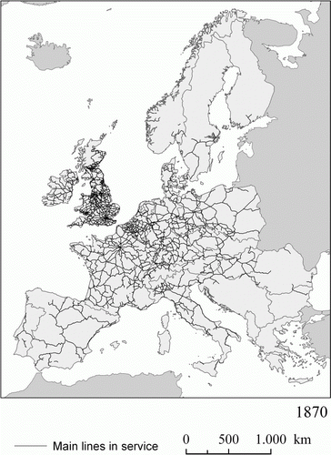
Table 2. Railway density (km railway/area km2) in 1870, 1900 and 1910.
has been divided into two maps that consecutively show the intense spread of the network between 1870 and 1900. In the maps, the reference borders used for the different countries are the current ones, despite the fact that great changes have taken place in Central Europe and these should be taken into consideration. The map for 1870 shows Europe in which it is already possible to speak of a structured network, despite the considerable differences in density that continued to exist. Both England and Wales and Belgium were areas of greater density, but that was not the case with Germany and France, while the Netherlands and the north of Italy already had an important level of infrastructure. Spain and, to a greater degree, Portugal, the Balkans and the Nordic countries still had relatively incipient railway networks at that time.
Figure 1b. Main railway lines (standard gauge) in service across Europe, 1900.
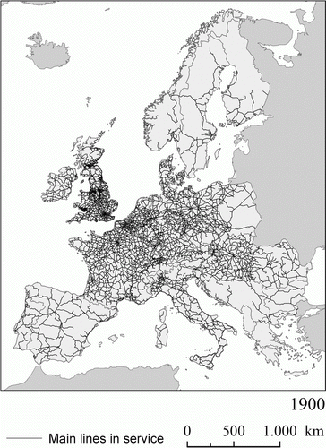
The map for 1900 shows that the railway network had undergone significant transformation during the previous 30 years. The number of countries that now had a good level of equipment had increased even more and those in the south of Europe had completed their networks. In the other peripheral areas, the situation varied enormously. The Nordic countries had considerably expanded their networks, and mainly done so to a greater extent than in the more populated south of Europe. In the Balkans, there was a dual tendency: while the territory belonging to the Austro-Hungarian Empire exhibited a rapid rate of railway investment, progress was much slower in the Ottoman Empire.
Moving beyond the maps in , in the 10 years between 1900 and 1910, the most significant increases took place in the Nordic countries and in Austria-Hungary. In 1910, Europe had a railway network that connected the main nuclei of population and production and points to feed the land transport system. However, in terms of its density, there were significant contrasts between the areas with the greatest capacity for investment and potential demand for transport, and the other, poorer and generally more peripherally located areas.
These considerations are confirmed by , which shows a generalised increase in the density of the network between 1870 and 1910. This format for presenting information confirms the distance that existed between Great Britain (the main island) and the other countries studied in 1870 with even greater precision. From then, the position of the modern-day territory of Germany had become similar to Britain. France also saw its railway network develop enormously during this period, while the other countries maintained their rather more modest positions.
3.2. European regional GDP
Before looking at how regional GDP levels relate to railway mileage, it is perhaps best to look at the GDP data alone. During the circa 1870 period, our starting point, industrialisation, had peaked in Britain and was moving quickly around the rest of Europe. The historiography tells us that the three leaders were Britain, France and Germany. supports this. What the historiography did not yet tell us is the extent of regional variation.
Figure 2. European Regional GDP per capita in 1990 Geary-Khamis dollars, 1870.
Sources: Authors' calculations based on sources in Section 2.4.
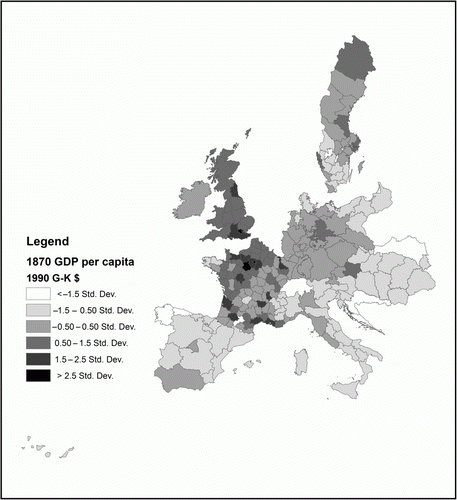
As expected, Britain's regions have high levels of GDP per capita. Income surrounds London and the industrial cores of Manchester (East Midlands), Sheffield (Yorkshire and the Humber) and Liverpool (north-west). As Crafts wrote, London had a large and growing lead over the rest of the country. The industrial cores, where the Industrial Revolution started, were falling behind London, but still ahead of the agricultural region of East Anglia.
France shows more regional variation. The Seine region and its neighbours show GDP per capita levels in line with those in Britain. The rest of the country, however, is composed of regions that are either average or below. The Massif Central in particular is considerably poorer than the rest of France. Most of these regions were agricultural, with little employment in services, home only to small-scale industry, and victims of demographic decline. Poor transport and communications made it yet harder for them to compete with the industrial North and Seine region.Footnote43
By contrast, Germany shows mostly average levels of regional GDP per capita at this stage. Levels are evenly spread across the country, except for Posen and East Prussia. These were among the most agricultural regions of the country, and had correspondingly low GDP per capita levels. Industrialisation came relatively late to these regions. Before the Zollverein removed internal tariff barriers and railways were built throughout the country in the mid-nineteenth century, archaic agricultural systems and social structures prevented the early adoption of industry there.Footnote44 Very much in this vein, Broadberry argues that similar factors – rural society and agricultural predominance – hindered the growth of the services sector.Footnote45 The same is not true of all German regions, however. The Rhineland, Saxony and Silesia, for example, managed to industrialise before the Zollverein and the general integration of Germany. Natural resources-rich Silesia was already the richest province in Habsburg Austria by 1740, when its annexation by Prussia began. According to our data, its GDP per capita was 27% higher than the Rhineland's by 1871. By way of illustration, in Saxony, industrialisation was already having significant (negative) effects on the nutritional status of citizens as early as the 1770s, with an accentuated decline after 1815.Footnote46
By contrast, Austro-Hungarian regions were and remained peripheral for much of the period. It is only Lower Austria, home to Vienna, which is above the European average at this stage. As Schulze argued, the Austria-Hungarian economy was in ‘stasis’. Initially low-level regions were growing as slowly as rich ones. This implied no intra-Empire catch-up, let alone convergence on its European neighbours. This is much like the situation in Spain, whose regional income levels were higher than Austria-Hungary's, but the country still found itself in a situation of slow growth. Roses et al. point out that although the national market was increasingly integrated during the period, there was little regional convergence; only the Basque Country improved its income ranking between 1860 and 1900. Spanish industrialisation was limited to certain regions – Catalonia, mainly – with the rest of the country remaining agrarian throughout the period.Footnote47
Moving to the middle of the period, circa 1900, a new pattern emerges as shown in . In Britain, income concentrated around London as the previous industrial cores declined in relative importance. In contrast, and in what is a more representative pattern of this time, France developed new industrial cores in addition to the Seine. One developed on the southern coast, centred on the Bouches-du-Rhône region, which is home to the busy port of Marseille, and a leading producer of soaps, chemicals and processed foods. Another developed in the very iron-rich region of Meurthe-et-Moselle, and one more around the major shipbuilding region of Charente-Maritime. The French interior remains relatively poor, with the exception of the Rhône region, home to the city of Lyon, with its thriving silk and chemical industries. In this period, France again shows the second highest regional GDP per capita inequality, with a variation coefficient of 32% (zero variation would indicate perfect income equality). Heywood, without any data to hand, hypothesised that French regional income inequality was probably the highest in Europe. He was almost right: Spanish regional inequality was higher, with a variation coefficient of 41%.Footnote48 Spain saw the emergence of two new leaders: Catalonia (home to Barcelona) and the Basque Country. These regions both had coastal access, in contrast to Madrid whose importance began to decline at this point, and in the case of the Basque Country, rich iron ore resources.
Figure 3. European Regional GDP per capita in 1990 Geary-Khamis dollars, 1900.
Sources: Authors' calculations based on sources in Section 2.4.
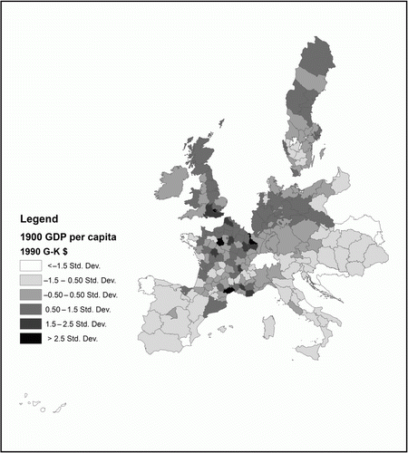
Similar patterns of growing inequalities can be seen in Austria-Hungary, with the Danube Tisza Basin (home to Budapest) emerging as a relatively more productive region to the rest of the country, and with Lower Austria maintaining its lead. In Italy, Liguria, where the busy port city of Genoa is found, emerged as a rival to Rome. While Stockholm remained the most productive part of Sweden, income levels grew around the region of Gävleborg. Its capital, Gävle, was a port city that exported copper and iron from the northern regions through Stockholm and onto the rest of the world.
Germany shows the most drastic change at this stage. It went from being an overall below-average income country to one with a high proportion of above-average GDP per capita regions. The turn of the century also saw Germany's old industrial regions – most notably, the Rhineland, Saxony and Brandenburg – in full swing. In aggregate, it was one of the fastest growing European countries of the period, rivalling even the USA. This was largely due to its reallocation of labour from agriculture to other parts of the economy, and due to productivity gains within the services sector, as argued by Broadberry.Footnote49 This growth seems to have pulled up the levels of all the regions, but was clearly centred on the stretch of industrial regions running from the Rhineland through to Silesia. These new concentrations of industry, growing in stark contrast to their less industrial and agricultural neighbours, raised overall regional GDP per capita inequality.
The final map indicates that there was a lot of change in the final years of the period. is an overall lighter shade. Income is concentrated in a very few regions, which are in turn mainly in the north-west of Europe. Indeed, apart from Hérault which used to produce coal and is home to Montpellier, all the regions below 47-degree latitude are either average or below-average GDP per capita regions. The perimeter of the periphery had moved farther north. Above that line of latitude, however, there were particularly productive regions.
Figure 4. European Regional GDP per capita in 1990 Geary-Khamis dollars, 1910.
Sources: Authors' calculations based on sources in Section 2.4.
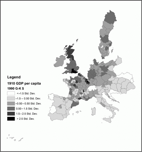
First, there is Meurthe-et-Moselle, the French region that lies between Alsace-Lorraine (Germany) and Meuse. Much of this region had been annexed by Germany after the Franco-Prussian War, but in what proved to be a poor strategic decision, Bismarck spared the part of the region that was rich in iron ore. According to Price, the Lorraine region, which included Meurthe-et-Moselle, was producing some 10% of total world iron ore and 66% of France's cast iron by 1911. On the same line of latitude, there is the less productive Seine metropolitan area. This area maintained a relatively high-income position, but fell behind in per capita terms because its population was increasing faster than output due to internal migration. In fact, our data show that the Seine region was still the wealthiest in total GDP terms. Moving slightly farther north, Price writes that the Nord and Palais-de-Calais regions produced some 66% of French coal output, and contained 90% of France's flax mills by 1911. This area shows up as quite productive on the map, but not as productive as its neighbour across the channel.
London is the only region that maintained its position at the top of the GDP per capita hierarchy across all three benchmark years. Unsurpassed by the rapid industrialisation of central Germany or the iron production of eastern France, London was the nerve centre of the British Empire and a dominant force in global commerce and industry. In an often-cited paper, Allen showed that real wages in London during this time were substantially higher than those found in other European cities.Footnote50 This result for London is therefore hardly surprising.
4. Research agenda
Handling the issues outlined earlier requires a clearly defined empirical strategy and plan of work. This section discusses how we are analysing our GDP and railway data.
4.1. An econometric analysis of European regional income and railways
Our project adopts an econometric strategy that deals with the sometimes negative and sometimes positive effects of railways, while controlling for regions’ fixed characteristics. It is based on Donaldson's empirical analysis of railways and real agricultural income levels in nineteenth-century India.
In a three-region setting (Z, X and Y), where there is only one commodity, the regions are symmetrical in their exogenous characteristics, and they have symmetrical trade costs (T) with respect to each other, the following holds:
| 1. |
| ||||
| 2. |
| ||||
Put simply, the ratio W/T represents the inverse relationship between real income W and trade costs T. However, the relationship changes depending on the trade costs referred to in the denominator. Indeed, the logic implies that a reduction in trade costs is not good for all regions. The intuition behind the logic is as follows. When a region is home to expanding railway, its own real income rises because its trade costs and hence commodity prices drop. However, when its neighbouring regions – or its trading partners – are home to a more extensive railway network, then its real income drops. This negative spillover effect may arise for two reasons. First, the neighbours’ land rental costs have increased (because their own trade costs have fallen), which increased the prices of the goods exported to the region in question, hence dropping its real income level. Second, the region in question loses demand for its own exportable goods because its neighbours have found a cheaper supplier in each other. Its own relatively higher trade costs increase the price of its output as well as its imports.
Unlike Donaldson, we have no data on commodity prices, and our railway data are not detailed enough to allow the specific network routes between regions, that is, we cannot discern precisely which railways connect X and Y, but bypass Z. These data limitations mean that our empirical strategy is a reduced-form one. While we conceptualise that real income gains from railway expansion are the result of trade cost reductions, we cannot be empirically sure of it until some poor soul collects commodity price and transport cost data for these 200 regions over these benchmark years. For precise railway connections, we would also need data on railway stations and travel directions of the railways themselves. What we do have is regional railway mileage. This variable has its advantages. It allows us to capture within-region variation in transport infrastructure and, as continuous data, it allows us to proxy regional transport infrastructure quality or the degree of connectedness – unlike a rail access dummy, as in Donaldson and Atack et al. It is worth pointing out here the importance of transport infrastructure quality: research has found that a deterioration in infrastructure from the median to the 75th percentile raises transport costs by 12% points and reduces trade volumes by 28%.Footnote51
These data limitations and conceptual foundations motivate the baseline empirical implementation (1). We implement it for all neighbours of a region, and then only for its neighbours that are in the same country – to discern for the effects of tariffs and other international trade barriers. Neighbours are defined as those regions with which the region in question shares a border. Geographical proximity, especially for land-based trade, determines much of economic interaction; so bordering regions are the most relevant ones to analyse.Footnote52
where Y ot is GDP per capita in region o at year t. β o captures regional fixed effects, which eliminates constant region-specific variation over time, like coastal access or natural resources like coal. This is particularly important for our analysis, as it captures the variation that may have made some regions attractive to railway placement. RAIL is total regional railway mileage, and NRAIL is mileage of its neighbours. α is a constant term and ϵ an error term both with standard properties. In line with the conceptual basis, we expect the coefficient θ on NRAIL to be negative, capturing the negative spillover effects, and the coefficient γ on RAIL to be positive, capturing reduced trade costs for the region.
It should be pointed out here that expecting a negative coefficient on NRAIL does not reflect consensus view on spillover effects. Some might expect the coefficient to be positive due to market access effects. That is, as a neighbour's transport infrastructure improves, and hence so does its market access, region o's market access will also improve, and so will its income level. This argument, however, is not so straightforward. Relatively higher neighbour market access may draw firms and labour away from the region o, reducing its income level. It is easy to refer to studies that find evidence of both effects.Footnote53 Our empirical strategy can be seen as an exploration into the potential effects of regions’ own transport infrastructure as well as that of their neighbours. It will in no way close the case, but it does encourage us to think of the often overlooked negative or trade-diverting effects of transport improvements. This is the side of the debate we want to present. Furthermore, by specifying both RAIL and NRAIL, we can calculate quite simply the net social gain (or loss) of railway expansion. That is, even though we might expect a negative coefficient on NRAIL, a large enough positive coefficient on RAIL can outweigh this negative effect.
This strategy is our first analytical look into the data. It provides a concise way of teasing out relationships in our rail and GDP datasets, ties into the transport infrastructure and trade literature and provides a new point for debates on the economic geography of European historical development. We are testing the robustness of this strategy, by scrutinising the idea of non-random railway placement, and by unpacking the fixed effects. For example, the inclusion of dummy variables to capture certain geographical characteristics – like coastal access and being landlocked – allows us to capture some of the variation coming from cheaper transport alternatives (ocean freight) and from dependency on land transport (for landlocked regions).
We are well aware of the endogeneity issues that come with railway studies. As Fishlow put it some years ago now:Footnote54
A key issue, however, is whether such railroad influence was primarily exogenous or endogenous, whether railroads first set in motion the forces culminating in the economic development of the decade, or whether arising in response to profitable situations, they played a more passive role.
The new literature on railways and economic outcomes provides a number of methods of dealing with these issues, which we will implement. Atack et al., for example, use an instrumental variable approach: they use a variable (government road plans) that predicts gaining railway access (their main regressor), but is uncorrelated with the outcomes they are examining (urbanisation). We are currently experimenting with using population levels in preceding periods (that is, in t–1) to instrument RAIL, finding that it greatly improves the robustness of our results. The relationship between railway expansion and population change is well known. Indeed, Atack et al. model the effects of railway access on population density and urbanisation, finding in the case of urbanisation significant positive effects. Kotavaara et al. found that improvements in transportation boosted urbanisation in Finland, and Mojica and Martí-Henneberg found that railway expansion in France, Spain and Portugal had similar effects.Footnote55 The idea behind this instrument, and behind the findings in these papers, is that railways are built where demand is high, and demand is high where populations are large. Railways follow population as it is at the same time a labour pool (supply access) and a consumer pool (market access).
Before relying on this instrument, we had to know whether it can predict regional railway mileage, and is uncorrelated with real income, while controlling for fixed regional characteristics. Using the entire panel, the simple correlation between the instrument – the log of population levels in preceding periods (LPOP) – and the log of total regional railway mileage (RAIL) is 0.54; its correlation with neighbouring railway mileage (NRAIL) is 0.19; and its correlation with the log of GDP per capita levels (Y) is −0.09. Adding weight to these simple correlations, we found that the log of preceding population levels is also a strong predictor of the log of total regional railway mileage. A panel regression estimation, where we controlled for regions’ fixed characteristics, yielded a coefficient of 6.26, significant at 1%, with an R 2 of 0.11. These statistics provide strong support for the use of preceding population levels as an instrument.
That population levels in the preceding periods are unrelated to per capita income is hardly surprising. As the well-known demographer LeeFootnote56 put it:
[D]ozens of studies, starting with Kuznets’, have found no association between the population growth rate and per capita income growth rate … These studies control for other factors such as trade, aid and investment to varying degrees. Two recent studies add historical depth to this analysis; even within countries (and thus looking only at disequilibrium), over periods as long as a century or as short as 25 years, there is no significant association of [the population growth rate and the rate of change of per capita income], for either DCs or LDCs.
There are other instrumental variable techniques that can be implemented. Donaldson lays down a counterfactual railway network (one that was planned by the relevant authorities, but never realised) to examine potential placebo effects of railways on income levels. We do not have such plans of networks on a pan-European scale, but there are alternative counterfactual approaches mapped out in the literature that are easier to implement in our context. In the economic history literature, for example, Casson's recent book constructs an ideal counterfactual railway network for Victorian Britain; his methods can be applied to other countries.Footnote57 Similarly, the economics literature provides examples of the construction of least-cost path spanning tree networks that connect nodes across space.Footnote58 These methods, however, only exist to provide an instrument for econometric estimation. As we have found population levels to be a reliable instrument, it is not clear whether making a number of assumptions and using GIS techniques to construct counterfactual data series would bring any additional value to the project.
Our model is parsimonious. We do not claim that the only variables that affect per capita income are related to railways. The relevant literature is awash with potential income determinants, and there are many things we have not controlled for, despite the highly adjusted R 2, but these potential determinants would only affect our results if they exert some sort of an influence on our independent variables. Even then, we have used an instrumental variable approach, to isolate plausibly random variation in railway mileage, diminishing the risk of omitted variable bias. There may be an argument for fully identifying the model, and instrumenting NRAIL as well. We intend on implementing such an approach in our future work. Still, the purpose of our empirical work is not to set up a horse race between potential income determinants and assess their relative merits. There is enough of that work already. We are content with getting an accurate as possible read on the coefficients of our variables, RAIL and NRAIL.
4.2. Railways and regional GDP per capita
How does the empirical strategy perform in practice? By taking Sweden and Austria-Hungary as examples, we can draw a few preliminary insights. shows summary statistics for the two countries. Austria-Hungary is composed of 22 regions, while Sweden is composed of 24. Both countries have data covering the decadal benchmark years from 1870 to 1910.
Table 3. Summary statistics for Austria-Hungary and Sweden.
The statistics show that at least one benchmark year, there were regions in both countries with no railway mileage at all. While inequality in regional GDP per capita, as measured by the variation coefficient, is similar, inequality in RAIL as well as NRAIL is much higher in Sweden. Mean regional rail mileage was higher in Austria-Hungary, and so was the maximum regional rail mileage. This fits with what the historical literature tells us about Swedish railway development. That is, it started later than its European neighbours, and that it met problems of funding along the way, hindering its already late development.Footnote59 alone indicates a lot of exploitable variation in our data-set. Indeed, when analysing the full sample, there may be scope to implement quantile regression to check for differing effects across quantiles of data.
shows the two-stage least squares results of model (1), where RAIL was instrumented with LPOP. The first stage shows that LPOP is a reliable instrument. It has a large and highly significant coefficient, with the expected positive sign. This stage shows an adjusted R 2 of 66%, further supporting the reliability of LPOPand, more generally, the use of an instrumental procedure for these data. In the second stage, where GDP per capita is regressed on RAIL and instrumented-NRAIL, we see an equally good fit: an adjusted R 2 of 61%. That is, regions’ own railway mileage along with that of their immediate neighbours and their fixed effects account for 61% of the variation in regional GDP per capita levels. Whether good or bad, railways were certainly having an effect on income levels. More specifically, the coefficient on RAIL is significant at the 1% level while the coefficient on NRAIL is significant at 10%, indicating, perhaps unsurprisingly, that own railway mileage was much more important. Both these coefficients show the expected sign. A 10% increase in a region's own railway mileage results in a 1.02% increase in its GDP per capita level. By contrast, a 10% increase in the railway mileage of all its immediate neighbours results in a 0.27% decrease in its GDP per capita level. The interpretation of NRAIL is somewhat complex, not least because its level of statistical significance is low, but also because of the way it is defined. To realise this predicted effect, we would need to imagine a scenario where all of the region's immediate neighbours increase their railway mileage, as it is the effect of total neighbour mileage. This is, of course, unlikely, but for now, it does tell us that there are some negative spillovers at work. Fundamentally, though, railway expansion resulted in a net social gain (as measured by GDP per capita) – the coefficient on RAIL is almost four times as large as that on NRAIL.
Table 4. Instrumental variable regression results of (1).
These empirical results lend support to the conceptual foundations outlined earlier, drawn from Donaldson. If a region expands its railway mileage, its own real income rises because its trade costs and hence commodity prices drop. However, if its neighbours or trading partners do the same, then its real income drops. This is due to the increase in neighbours’ land rental costs, which increase the prices of exports, and because the region loses demand for its own exports, as the neighbours begin to supply each other.
While we have outlined a specific empirical strategy and applied it to a subsample as a preliminary test, we hope to see the development of new econometric strategies to address this topic, and we also want to make clear the broader appeal of our research and data. This is the basis of our discussion in the following section.
5. Suggested lines for future research on railways
A description of the general objectives of this research is necessary, which extend beyond the limits of the subject of railways discussed here. In fact, when digitalising the evolution of the European railway network, the aim has been to contribute to a better understanding of the transformations that have taken place in Europe from a spatio-temporal perspective. As a result of this rather wide approach, we shall also try to examine its potential with respect to the participation of other researchers.
The general aim is to analyse the uneven geographical transformation of Europe from the mid-nineteenth century to the present day. This will be done at both the general scale, for the whole of Europe, and at a more detailed level, for individual countries for which more precise information is available.Footnote60 This will allow us to achieve a more specific aim: to develop a methodology based on GIS and to use this to carry out a more detailed analysis of the interrelationships between a complex range of indicators.Footnote61
As we previously mentioned, historical datasets are needed to meet these objectives, which include obtaining a range of geo-referenced information relating to different socio-economic topics and inland transport infrastructure and presenting them in a digital format. Some initial examples of this work can be seen in a special issue of the Journal of Interdisciplinary History.Footnote62 All this information could also be used separately to produce an interesting narrative for each specific subject, such as the evolution of the railway network. However, it should also be stressed that the most relevant potential derives from analysing these themes together, using GIS. This presents the possibility of considering traditional subjects from a different perspective and also bringing new ones into the academic arena.
In addition, this project offers the opportunity to promote interdisciplinary research done by geographers, historians, engineers and economists, among others. These experts can thus share their knowledge and expertise to help improve the general understanding of the economic and social processes involved in the development of transportation networks in different parts of Europe between about 1850 and the present day.
The research project presented here has been organised around a number of main research topics and based on the initial hypothesis that European Integration is a long-term process that predates the EU institutions. The degree of European Integration needs to be measured in terms of the level of integration between states through the interconnectivity of their transport networks and through cross-border continuity with the help of socio-demographic indicators at the regional scale. By doing this, we intend to show that it is possible to empirically evaluate the process of territorial integration at the pan-European scale over longer time scales.
Starting from this general idea, we are interested in studying changes in the distribution of population, which have been significantly related to access to new means of transportation. In the nineteenth century, railways would have helped to promote new areas and those with previous economic activity and the capacity for growth were particularly successful at attracting population. As shown in the review and literature, some results of this type have already been obtained, but there is still plenty of scope to continue working along these lines. Another aspect to consider is the territorial measurement of accessibility, which is a key factor when measuring uneven regional development. This is a subject that is currently being analysed by us at the country level, although the study could be extended in both directions: a global approach for Europe and an integration of data on accessibility at the local level with other physical and socio-economic indicators that would allow us to discover the weight of historical factors in regional imbalances of wealth.
6. Conclusion
In this article, we presented and discussed our dataset on European regional GDP and railways, covering the period between 1870 and 1910. In so doing we have highlighted the need to drill deeper into the changing directional effects of railways on income, that is, railways can have both negative and positive economic effects, and we have also highlighted the importance or necessity of using regional-level data, given railways spread so unevenly across and within countries.
Our dataset is already so large in scale and scope; the research agenda we have outlined here can only be a first effort at exploiting its potential. We thus suggested other ways of taking our dataset forward. Examples of potential future research include looking at the intensity of European Integration through the connectivity and continuity of transport networks themselves, and the effects these networks have on changing population and settlement patterns. Another area of potential we suggested is using the railway data to look into the relationship between (market) accessibility and economic development. This is a growing field in both economics and economic history.Footnote63 More fundamentally, our database, we hope, will be a useful resource for all those working on the broad area of European economic history. That the database is constructed in a GIS, and so all data are geo-referenced, makes it easier for researchers to build on, testing economic and historical relationships drawn from their own area of expertise.
Acknowledgements
The Spanish Ministry of Education (CS02010-16389), the UK Economic and Social Research Council (ES/I011161/1) and the EU Social Fund and Maltese Ministry of Education (STEPS) provided funding for this research. We should also like to thank seminar participants in Venice, two anonymous referees and Jacob Weisdorf for useful comments and suggestions.
Notes
1O'Brien, The New Economic History (Citation1977).
2Collins, ‘Labor Mobility’ (Citation1999).
3Bogart, ‘Turnpike’ (Citation2005).
4Fogel, Railroads (Citation1964).
5Foreman-Peck, New Perspectives (Citation1991).
6Leunig, ‘Time is Money’ (Citation2006).
7Herrendorf et al., ‘Transportation and Development’ (Citation2009).
8Atack et al., ‘Did Railroads’ (Citation2010).
9Donaldson/Hornbeck, ‘Railroads’ (Citation2011).
10The authors use a measure of market access – a transport and trade cost weighted measure of market size – to capture network structure. We do not do this in our project, as it is part of another project: Caruana-Galizia, European Regional Income (Citation2012).
11Donaldson, ‘Railroads’ (Citation2010).
12Bogart, ‘Turnpike Trusts’ (Citation2009); Bogart, ‘Neighbors’ (Citation2007).
13O'Brien, Railroads (Citation1983).
14Herranz-Loncán, ‘Railroad Impact’ (Citation2006).
15Mojica/Martî-Henneberg, ‘Railroads and Population’ (Citation2011).
16Kotavaara et al., ‘Urbanization and Transportation’ (Citation2011).
17Schulze, ‘Regional Income’ (Citation2007); Buyst, ‘Reversal of Fortune’ (Citation2009); Crafts, ‘Regional GDP’ (Citation2005); Felice, ‘Estimating Regional GDP’ (Citation2009); Enflo et al., ‘Swedish Regional GDP’ (Citation2010); Roses et al., ‘The Upswing’ (Citation2010).
18For Portugal, see, Badio-Miro et al., ‘Reconstruction of the Regional GDP.’ (Citation2012).
19For France, see Caruana-Galizia, ‘Estimating French Regional Income’ (Citation2013). For Germany, see Schulze/Caruana-Galizia, ‘De-Industrialisation’ (Citationforthcoming).
20This matters in both an absolute and relative sense. Countries in the tropics were found to be at an economic disadvantage, according to Sachs et al., ‘Geography and Economic Development’, (1999). More recent research has shown that countries’ relative positioning to one another – their spatial linkages – also has effects on income levels, according to Bosker/Garresten, ‘Economic Development’ (Citation2009).
21NUTS (Nomenclature of Units for Territorial Statistics) is a European Union level of aggregation largely based on historical administrative boundaries. The levels range from NUTS-1 (for example, groups of states), to NUTS-2 (for example, states or provinces) and NUTS-3 (for example, counties).
22Caruana-Galizia, ‘Market Access.’ (Citation2012).
23Briant et al., ‘Dots to Boxes’ (Citation2010).
24Martí-Henneberg, ‘The Map of Europe’ (Citation2005a).
25Martí-Henneberg, ‘Empirical Evidence’ (Citation2005b).
26Puffert, Tracks Across Continents (Citation2009); Carreras et al., European Networks (Citation1994).
27The regional unit used is relatively small and has been adapted in line with the historical tradition of each country (using the county in the UK, department in France and province in Spain and Italy, etc.).
28The historical archives of the Bartholomew Company are now held in the Scottish National Archives in Edinburgh.
29A recent work has explained how our group produced a GIS for railroads in Europe (Morrillas-Torné, ‘Creation of a Geo-Spatial Database’ , Citation2012). It is also possible to consult some other material on the Internet (www.europa.udl.cat).
30Morillas et al., ‘Urban Transformation’ (Citation2012).
31The project is funded by the European Science Foundation, and is called the Historical Economic Geography of Europe, 1900–2000.
32For France, see Caruana-Galizia, ‘Estimating French Regional Income’ (Citation2013). For Germany, see Schulze/Caruana-Galizia, ‘De-Industrialisation ’ (Citationforthcoming).
33Geary/Stark, ‘Examining Ireland's’ (Citation2002).
34Maddison, The World Economy (Citation2003).
35Prados de la Escosura, ‘International Comparisons.’ (Citation2000).
36Smits et al., ‘A Dataset’ (Citation2009).
37Toutain, ‘Le produit interieur brut’ (Citation1987).
38Wolf, Regional GDP (Citation2010).
39Felice, ‘Estimating Regional GDP in Italy (1871–2001)’ (2009).
40Jorberg, A History of Prices (Citation1972).
41Jacks, ‘Intra- and International Commodity’ (Citation2005).
42Ward/Devereux, ‘Measuring British Decline’ (Citation2003).
43Price, An Economic History (Citation1981).
44Tilly, ‘Germany’ (Citation1967).
45Broadberry, ‘Explaining Anglo-German Productivity’ (Citation2004).
46Cinnirella, ‘On the road’ (Citation2008).
47Roses et al., ‘The Upswing’ (Citation2010).
48Heywood, The Development (Citation1995).
49Broadberry, ‘Anglo-German Productivity Differences’ (Citation1997).
50Allen, ‘The Great Divergence’ (Citation2001).
51Limao/Venables, ‘Infrastructure’ (Citation2001).
52This was accepted early in the economic history literature: North, ‘Location Theory’ (Citation1955). It has received more attention from scholars of trade and economic geography: Overman et al., ‘The Economic Geography’ (Citation2003).
53See, for example, Donaldson, ‘Railroads’ (Citation2010) on trade diversion, and Donaldson/Hornbeck, ‘Railroads’ (2012) for a market access approach to valuing railroads.
54Fishlow, American Railroads (Citation1965), 203.
55Kotavaara et al., ‘Urbanization and Transportation ’ (Citation2011); Mojica/Marti-Henneberg, ‘Railways and Population’ (Citation2011).
56Lee, ‘Economic Consequences’ (Citation1983), 54. References have been omitted and algebraic notation is restated in prose.
57Casson, The World's First Railway System (Citation2009).
58Faber, ‘Trade Integration’ (Citation2012); Banerjee et al., ‘On the Road’ (Citation2012).
59Magnusson, An Economic History (Citation2000).
60This analysis is already on the way (Morillas et al., ‘Urban Transformation’ (Citation2012)).
61See Gregory/Martí-Henneberg, ‘The Railroads’ (Citation2010); Schwartz et al., ‘Spatial History’ (Citation2011a), Schwartz et al., ‘History and GIS’ (Citation2011b).
62 Journal of Interdisciplinary History Summer 2011, Vol. 42, No. 1.
63See, for example, Donaldson/Hornbeck, ‘Railroads’ (2012) or Schulze, ‘Regional Income’ (Citation2007). Both papers look specifically into the issue of accessibility and income, but use different conceptions and implementations of accessibility.
References
- Allen , R.C. 2001 , ‘ The Great Divergence in European Prices and Prices from the Middle Ages to the First World War ’ in : Explorations in Economic History 38 , no. 4 , 411 – 47 . doi: 10.1006/exeh.2001.0775
- Atack , J. , et al. 2010 , ‘ Did Railroads Induce or Follow Economic Growth? Urbanization and Population Growth in the American Midwest, 1850–1860 ’ in : Social Science History 34 , no. 2 , 171 – 97 . doi: 10.1215/01455532-2009-024
- Badio-Miro , M. , et al. 2012 , ‘ Reconstruction of the Regional GDP of Portugal, 1890–1980 ’, Documents de Treball de la Faculta d'Economia I Empresa, no. E12/280 .
- Banerjee , A. , et al. 2012 , ‘ On the Road: Access to Transportation Infrastructure and Economic Growth in China ’, NBER Working Paper, no. 17897 .
- Bogart , D. 2005 , ‘ Turnpikes and the Transport Revolution in 18th Century England ’ in : Explorations in Economic History 42 , no. 4 , 479 – 508 . doi: 10.1016/j.eeh.2005.02.001
- Bogart , D. 2007 , ‘ Neighbors, Networks, and the Development of Transport Systems: Explaining the Diffusion of Turnpike Trusts in Eighteenth-century England ’ in : Journal of Urban Economics 61 , no. 2 , 238 – 62 . doi: 10.1016/j.jue.2006.11.002
- Bogart , D. 2009 , ‘ Turnpike Trusts and Property Income: New Evidence on the Effects of Transport Improvements and Legislation in Eighteenth-Century England ’ in : Economic History Review 62 , no. 1 , 128 – 52 . doi: 10.1111/j.1468-0289.2008.00434.x
- Bosker , M. / Garresten , H. 2009 , ‘ Economic Development and the Geography of Institutions ’ in : The Journal of Economic Geography 9 , no. 3 , 295 – 328 . doi: 10.1093/jeg/lbn047
- Briant , A. , et al. 2010 , ‘ Dots to Boxes: Do the Size and Shape of Spatial Units Jeopardise Economic Geography Estimations? ’ in : Journal of Urban Economics 67 , no. 3 , 287 – 302 . doi: 10.1016/j.jue.2009.09.014
- Broadberry , S.N. 1997 , ‘ Anglo-German Productivity Differences, 1870–1990: A Sectoral Analysis ’ in : European Review of Economic History 1 , 247 – 67 . doi: 10.1017/S1361491697000117
- Broadberry , S.N. 2004 , ‘ Explaining Anglo-German Productivity Differences in Services since 1870 ’ in : European Review of Economic History 8 , no. 3 , 229 – 62 . doi: 10.1017/S1361491604001200
- Buyst , E. 2009 , ‘ Reversal of Fortune in a Small, Open Economy: Regional GDP in Belgium, 1896–2000 ’ VIVES Research Centre for Regional Economics, http://www.econ.kuleuven.be/vives/PUBLICATIES/DP/DP2009/Vivesdiscussionpaper8.pdf
- Carreras , A. et al. 1994 , European Networks, 19th–20th Centuries: New Approaches to the Formation of a Transnational Transport and Communications System , Milan : International Economic History Congress .
- Caruana-Galizia , P. 2012 , ‘ Market Access and Human Capital: European Regions, 1870–1910 ’, mimeo, London School of Economics .
- Caruana-Galizia , P. 2012 , ‘European Regional Income, Institutions, and Market Access’ , mimeo , London School of Economics .
- Caruana-Galizia , P. 2013 , ‘ Estimating French Regional Income: Departmental Gross Value Added per Capita, 1872–1911 ’, Research in Economic History 29 , 71 – 95 .
- Casson , M. 2009 . The World's First Railway System Enterprise, Competition, and Regulation on the Railway Network in Victorian Britain , Oxford : Oxford University Press .
- Cinnirella , F. 2008 , ‘ On the Road to Industrialisation: Nutritional Status in Saxony, 1690–1850 ’ in : Cliometrica 2 , no. 3 , 229 – 57 . doi: 10.1007/s11698-007-0020-6
- Collins , W.J. 1999 , ‘ Labor Mobility, Market Integration, and Wage Convergence in Late 19th Century India ’ in : Explorations in Economic History 36 , no. 3 , 246 – 77 . doi: 10.1006/exeh.1999.0718
- Crafts , N.F.R. 2005 , ‘ Regional GDP in Britain, 1871–1911: Some Estimates ’ in : Scottish Journal of Political Economy 52 , no. 1 , 54 – 64 . doi: 10.1111/j.0036-9292.2005.00334.x
- Donaldson , D. 2010 , ‘ Railroads of the Raj: Estimating the Impact of Transport Infrastructure ’, NBER Working Paper No. 16487, http://www.nber.org/papers/w16487
- Donaldson , D. / Hornbeck , R. 2011 , ‘ Railroads and American Economic Growth: New Data and Theory ’, Harvard University mimeo, http://www.gsb.stanford.edu/facseminars/events/applied_microecon/documents/ame_10_11_hornbeck.pdf
- Enflo , K. , et al. . 2010 , ‘ Swedish Regional GDP, 1855–2000: Estimations and General Trends in the Swedish Regional System ’, Universidad Carlos III de Madrid Working Papers in Economic History, WP 10-03, http://orff.uc3m.es/bitstream/10016/7125/1/wp_10-03_.pdf
- Faber , B. 2012 , ‘Trade Integration, Market Size, and Industrialisation: Evidence From China's National Trunk Highway System’ , mimeo , London School of Economics .
- Felice , E. 2009 , ‘ Estimating Regional GDP in Italy (1871–2001): Sources, Methodology, and Results ’, Universidad Carlos III de Madrid Working Papers in Economic History, WP 09-07, http://orff.uc3m.es/bitstream/10016/5334/5/wp-09-07.pdf
- Fishlow , A. 1965 . American Railroads and the Transformation of the Ante-bellum Economy , Cambridge , MA : Harvard University Press .
- Fogel , W.R. 1964 . Railroads and American Economic Growth: Essays in Econometric History , Baltimore : Johns Hopkins University Press .
- Foreman-Peck , J. 1991 . New Perspectives on the Late-Victorian Economy: Essays in Quantitative Economic History, 1860–1914 , Cambridge : Cambridge University Press .
- Geary , F. / Stark , F. 2002 , ‘ Examining Ireland's Post-Famine Economic Growth Performance ’ in : The Economic Journal 112 , 919 – 35 . doi: 10.1111/1468-0297.00064
- Gregory , I.N. / Martí-Henneberg , J. 2010 , ‘ The Railroads, Urbanization, and Local Demography in England and Wales, 1825–1911 ’ in : Social Science History 34 , no. 2 , 199 – 228 . doi: 10.1215/01455532-2009-025
- Herranz-Loncán , A. 2006 , ‘ Railroad Impact in Backward Economies: Spain, 1850–1913 ’ in : The Journal of Economic History 66 , no. 4 , 853 – 81 .
- Herrendorf , B. , et al. 2009 , ‘ Transportation and Development: Insights from the U.S., 1840–1860 ’, Federal Reserve Bank of Minneapolis Research Department Staff Report 425, http://minneapolisfed.org/research/sr/sr425.pdf
- Heywood , C. 1995 . The Development of the French Economy, 1750–1914 , Cambridge : Cambridge University Press .
- Jacks , D.S. 2005 , ‘ Intra- and international commodity market integration in the Atlantic economy, 1800–1913 ’ in : Explorations in Economic History 42 , 381 – 413 . doi: 10.1016/j.eeh.2004.10.001
- Jorberg , L. 1972 . A History of Prices in Sweden, 1732–1914 , Lund : CWK Gleerup .
- Kotavaara , O. , et al. 2011 , ‘ Urbanization and Transportation in Finland, 1880–1970 ’ in : The Journal of Interdisciplinary History 42 , no. 1 , 89 – 109 . doi: 10.1162/JINH_a_00206
- Leunig , T. 2006 , ‘ Time is Money: A Re-Assessment of the Passenger Social Savings from Victorian British Railroads ’ in : The Journal of Economic History 66 , no. 3 , 635 – 73 . doi: 10.1017/S0022050706000283
- Lee , R. 1983 , ‘ Economic Consequences of Population Size, structure, and Growth ’ in : International Union for the Scientific Study of Population Newsletter 17 , 43 – 59 .
- Limao , N. / Venables , A.J. 2001 , ‘ Infrastructure, Geographical Disadvantage, Transport Costs, and Trade ’ in : World Bank Economic Review 15 , no. 3 , 451 – 79 . doi: 10.1093/wber/15.3.451
- Maddison , A. 2003 . The World Economy: Historical Statistics , Paris : OECD .
- Magnusson , L. 2000 , ‘ An Economic History of Sweden ’, London : Routledge .
- Martí-Henneberg , J. 2005a , ‘ The Map of Europe. Continuity and Change of the Administrative Boundaries (1850–2000) ’ in : Geopolitics 10 , 791 – 815 . doi: 10.1080/14650040500318589
- Martí-Henneberg , J. 2005b , ‘ Empirical Evidence of Regional Population Concentration in Europe (1870–2000) ’ in : Population, Space and Place 11 , 269 – 81 . doi: 10.1002/psp.373
- Mojica , L. / Martí-Henneberg , J. 2011 , ‘ Railroads and Population Distribution: France, Spain, and Portugal, 1870–2000 ’ in : The Journal of Interdisciplinary History 42 , no. 1 , 15 – 28 . doi: 10.1162/JINH_a_00203
- Morillas , M. , et al. 2012 , ‘ Urban Transformation and the Development of Spain's Railroad Network 1850–2000 ’, paper presented at the 32nd International Geographical Congress , Cologne 26 Aug. 2012 ( accepted for publication as a book chapter ).
- Morrillas-Torné , M. 2012 , ‘ Creation of a Geo-Spatial Database to Analyse Railroads in Europe (1830–2010). A Historical GIS Approach ’ in : Journal of Geographic Information System 4 , no. 2 , 176 – 187 .
- North , D.C. 1955 , ‘ Location Theory and Regional Economic Growth ’ in : The Journal of Political Economy 63 , no. 3 , 243 – 58 . doi: 10.1086/257668
- O'Brien , P.K. 1977 . The New Economic History of the Railroads , London : Routledge .
- O'Brien , P.K. 1983 . Railroads and the Economic Development of Western Europe, 1830–1914 , London : Palgrave Macmillan .
- Overman , H. , et al. 2003 , ‘ The Economic Geography of Trade, Production and Income: A Survey of Empirics ’, in: Handbook of International Trade. Blackwell Handbooks in Economics , E.K. Choi / J. Harrigan , Oxford : Blackwell , 353 – 87 .
- Prados de la Escosura , L. 2000 , ‘ International Comparisons of Real Product, 1820–1990: An Alternative Data Set ’ in : Explorations in Economic History 37 , no. 1 , 1 – 41 . doi: 10.1006/exeh.1999.0731
- Price , R. 1981 . An Economic History of Modern France, 1730–1914 , London : Macmillan Press .
- Puffert , D. 2009 . Tracks across Continents, Paths through History: The Economic Dynamics of Standardization in Railway Gauge , Chicago : University of Chicago Press .
- Roses , J.R. , et al. 2010 , ‘ The Upswing of Regional Income Inequality in Spain (1860–1930) ’ in : Explorations in Economic History 47 , no. 2 , 244 – 57 . doi: 10.1016/j.eeh.2010.01.002
- Schulze , M.S. 2007 , ‘ Regional Income Dispersion and Market Potential in the Late Nineteenth Century Hapsburg Empire ’ LSE Economic History Working Paper, 106/07, http://eprints.lse.ac.uk/22311/
- Schulze , M.S. / Caruana-Galizia , P. ( forthcoming ), ‘De-Industrialisation in Germany and Austria-Hungary, 1870–1911’ , London School of Economics , mimeo .
- Schwartz , R.M. , et al. 2011a , ‘ Spatial History: Railroads, Uneven Development, and Population Change in France and Great Britain, 1850–1914 ’ in : The Journal of Interdisciplinary History 42 , no. 1 , 53 – 88 . doi: 10.1162/JINH_a_00205
- Schwartz , R. 2011b . “ History and GIS: Railroads, Population Change, and Agricultural Development in Late Nineteenth Century Wales ” . In GeoHumanities: Art, History, Text at the Edge of Place , Edited by: Dear , M. 251 – 66 . Abingdon : Routledge .
- Smits , J.P. , et al. 2009 , ‘ A Dataset on Comparative Historical National Accounts, ca. 1870–1950: A Time-series Perspective ’, Groningen Growth and Development Centre Research Memorandum GD-107, http://www.ggdc.net/publications/memorandum/gd107.pdf
- Tilly , R. 1967 , ‘ Germany: 1815–1870 ’, in: Banking in the Early Stages of Industrialization: A Study in Comparative Economic History , R. Cameron , et al. , Oxford : Oxford University Press , 151 – 82 .
- Toutain , J.C. 1987 , ‘ Le produit interieur brut de la France de 1789 a 1982 ’ in : Economies et Societes 15 , 1 – 237 .
- Ward , M. / Devereux , J. 2003 , ‘ Measuring British Decline: Direct versus Long-Span Income Measures ’ in : Journal of Economic History 63 , no. 3 , 826 – 51 . doi: 10.1017/S0022050703542000
- Wolf , N. 2010 , ‘Regional GDP across Germany, 1895–2000. Some First Estimates at the Level of NUTS-1’ , London School of Economics , mimeo .