
Abstract
The article describes the geomorphic systems of spatial reference in the two Indo-Aryan languages Palula and Kalasha, spoken in adjacent areas of an alpine region in Northwestern Pakistan. Palula and Kalasha encode the inclination of the mountain slope as well as the flow of the river, in systematic and similar ways, and by use of distinct sets of nominal lexemes that may function adverbially. In their verbal systems, only Palula encode, landscape features in a systematic way, but both languages make use of a number of verbal sets that in different ways emphasise boundary-crossing. The article relates the analysis to Palmer's Topographic Correspondence Hypothesis that predicts that the linguistic system of spatial reference will reflect the topography of the surrounding landscape. The analysis of the geomorphic systems in Palula and Kalasha supports this hypothesis. However, data from a survey of spatial strategies in neighbouring languages, i.e., languages spoken in a similar alpine landscape, reveal another system that does not to the same extent or in a similar way encode typical landscape features such as the mountain slope and the flow of the river. This calls for a revision of Palmer's hypothesis that also takes language contact into consideration.
1. Introduction
This paper investigates parallel and different strategies of geomorphic coding in the two neighbouring Indo-Aryan languages Palula and Kalasha. The geographical region in which the two languages are spoken is alpine, characterised by high mountains, narrow passages, and a system of rivers and streams crossing through its inhabited and cultivated areas. In both languages, expression of what we may call spatiality – including typical landscape features such as rivers and mountain slopes – is particularly pervasive and is reflected in a variety of semantic and grammatical layers: in the case-marking of nouns, in the use of relational nouns, in their deictic adverbial systems, as motion verbs with lexical specifications related to orientation and directionality, or in various combinations of those.
Languages’ ways of encoding such landscape features in their grammars and their lexicons have attracted increasing attention from both typology and language theory within the past 20–25 years. Typological research has pointed out that languages use a variety of geomorphic, so-called “frames of reference” (FoR; see below), i.e., “coordinate systems” for expressing the spatial relationship between two entities. This paper has as one of its aims to contribute to this perspective by describing how the two genetically related and neighbouring – yet distinct – languages Palula and Kalasha make use of and combine two geomorphic systems, one based on the flow of a river, a riverine system, the other based on the inclination of mountain sides.
As a starting point for the description of the geomorphic systems in Palula and Kalasha, we make use of the Topographic Correspondence Hypothesis (TCH), as recently proposed by Palmer (Citation2015). According to TCH, a “correlation will exist between a language’s system of … spatial reference and the topography of the language locus” (Palmer Citation2015, 210). Hence, TCH predicts that languages spoken in similar topographic environments will tend to have similar systems of absolute spatial reference. Based on the description of how Palula and Kalasha incorporate the topography in their grammars and lexicons, we will, as a second aim, discuss to what extent these systems are similar, and consequently to what extent TCH in its current formulation can predict a system of spatial reference.
A third and more modest aim of ours is historical. As will become clear, Palula and Kalasha do not incorporate similar topographical features in a uniform lexical and grammatical way, despite close genetic relationship, a shared topographic environment, and the fact that they are neighbouring languages. This, we will argue, can be seen as linguistic support of the local historical accounts of the different settlement patterns of the speakers of these two languages. Moreover, together with a few other neighbouring languages, Palula and Kalasha do indeed employ geomorphic coding based on the inclination of the mountain slope and the flow of the river. This is in contrast with other Hindu Kush languages, which in spite of shared alpine environment do not employ similar geomorphic coding strategies. We suggest that this calls for a supplementary revision of Palmer’s prediction that will take aspects of language contact into consideration.
The following section, Section 2, introduces the frame of reference (FoR) concept as established through recent cross-linguistic studies of spatial expressions. As a further development, laid out in Section 3, attempts have been made at describing and even predicting how certain types of FoR systems correspond to particular topographic environments. In Section 4, the two languages under investigation and their respective speaker communities are introduced, and their traceable phylogenetic relationship to one another is outlined. In Section 5 we describe geomorphic coding as it occurs in the various subsystems of Kalasha and Palula. In Section 6, we refer to similar coding in closely related or adjacent languages. Section 7 is the final discussion of our findings, where we offer a few tentative conclusions.
2. Spatial frames of reference
All languages have linguistic systems, Frames of Reference (FoR), for expressing the relationship between objects in physical space or the “path” along which objects move, or, as Terrill and Burenhult put it: “Frames of reference are coordinate systems for expressing the spatial relationship between Figure and Ground” (Terrill and Burenhult Citation2008, 93), following Talmy’s established terminology (Talmy Citation2000), where the Figure is the entity to be located and the Ground the location of the Figure. These systems represent a conceptual system called Frame of Reference (FoR), which provides a perspective, a coordinate system, used for the interpretation of a spatial relation. In Palmer’s words (Citation2015, 180): “A FoR is … in effect a strategy for projecting a search domain or path off a relatum [i.e., ground]”. In the literature a number of classifications of FoRs have been proposed. We base the following definitions on O’Meara and Pérez Báez (Citation2011, 3–8) and Palmer (Citation2015, 182ff),Footnote1 and we focus exclusively on those that are relevant for Palula and Kalasha in the analysis in Section 5.
In an object-centred or intrinsic FoR, for example, English The tree is in front of the house, the object to be located, the figure or referent, is the tree. The tree is located through a relation to a ground, or relatum, here house. The location of the tree is expressed by means of a search domain projected off an intrinsic or inherent facet of the relatum/ground, here the front or back of the house, which then serves as the anchor (Palmer Citation2015, 180, 182). In Palmer’s words (Citation2015, 182): “Anchor point A is conceptualised as an intrinsic facet of G. A search domain is projected off G on the basis of its facet A”. Or, in other words, “[t]he anchor point A is within relatum G” (Citation2015, 182). The facet of the relatum/ground that serves as the anchor may not be an actual inherent or intrinsic feature of the relatum/ground, but may instead be ascribed by the observer/speaker (Palmer Citation2015, 183). For example, in the English sentence The house is in front of the tree, the speaker assigns a front side or facet to an object without an inherent front.
Following Palmer (Citation2015, 182), the relation between the figure/referent and the relatum/ground in an intrinsic FoR is binary. To construct or interpret a spatial reference in such a case, it is necessary to know the location and the intrinsic facet of the relatum/ground. The reference is independent of any perspective outside of that dyad (Palmer Citation2015, 182).
In a geomorphic FoR, the anchor is an environmental feature, for example, a river or a slope, whose orientation is of crucial relevance.Footnote2 In Palmer’s words, this FoR
“is a strategy for projecting a search domain or path off a relatum [i.e., a ground] on the basis of an anchor outside the referent-relatum dyad [i.e., a figure-ground dyadic relation] other than a viewpoint, that anchor being a feature or features of an external world in which the referent-relatum dyad is perceived to be located” (Palmer Citation2015, 222).
In contrast to the binary object-centred or intrinsic FoR, a geomorphic FoR is a ternary relation because “the Anchor is located in the landscape … surrounding the Figure-Ground scene” (Danziger Citation2010, 169).
3. Topographic correspondence hypothesis
Research in semantic typology since the 1990s has pointed out that languages of the world may use a variety of FoRs, but also that some languages – and language groups – seem to prefer certain types of FoRs to others. Whereas intrinsic FoRs seem to be employed in all languages (Palmer Citation2015, 211), although to a varying extent, languages seem to prefer either geomorphic systems, absolute systems based on cardinal directions such as the compass directions, or the so-called relative FoRs (Palmer Citation2015, 211; Levinson and Wilkins Citation2006b, 22; Citation2006c, 541–542). The latter systems are based on notions such as right and left, for example, the tree is to the right of the chair. In such FoR systems the figure is located on a ground, chair, through an anchoring in the observer’s or addressee’s body, observer’s right-direction in the example the tree is to the right of the chair. A relative FoR system is fundamental for spatial reference in languages such as English, Swedish, and Danish, but not, for example, in many Meso-American and Australian languages (cf. Levinson Citation1996, Citation1998; Levinson and Wilkins Citation2006b; Pederson et al. Citation1998; Senft Citation1997, inter alia); and also not in Palula and Kalasha. In fact, languages spoken in urban environments seem to “prefer” relative FoR systems, while languages spoken in rural environments prefer geomorphic or absolute cardinal systems. “[W]hich is preferred appears to correlate with the environment in which the language is spoken” (Palmer Citation2015, 211, citing Majid et al. Citation2004, 11, and Burenhult and Levinson Citation2008, 136).
For Palmer (Citation2015), this indicates that phenomena in the external world, such as the flow of rivers, slopes, prevailing wind directions etc., lead speakers to “construct a spatial system with categories that are associated with them [i.e., the phenomena in the external world]” (Citation2015, 210). As Palmer (Citation2015) has its focus on absolute FoRs, including FoRs based on geomorphic and cardinal systems, this leads him to posit the Topographic Correspondence Hypothesis (TCH), that a “correlation will exist between a language’s system of absolute spatial reference and the topography of the language locus” (Palmer Citation2015, 210; see also Palmer Citation2002, 141–146). In fact, “absolute FoR in language reflects universal human cognitive responses to environment” (Palmer Citation2015, 223).
Palmer’s hypothesis makes two predictions: (1) Languages spoken in diverse topographic environments will tend to have systems of spatial reference that differ according to topographic variation; (2) languages spoken in similar topographic environments will tend to have similar systems of absolute spatial reference, regardless of phylogenetic, areal, or typological affiliation (Palmer Citation2015, 210). It is the second prediction that will be explored with the analysis of the FoRs in Palula and Kalasha below, although with the caveat that Palula and Kalasha are indeed phylogenetically related (Section 4.3). Therefore, we cannot fulfil Palmer’s requirement that for testing the hypothesis it is necessary to compare phylogenetically and areally unrelated languages spoken in similar environments, in order to rule out the possibility that similar systems may be due to either shared inheritance from an ancestor language or language contact (Palmer Citation2015, 214, 222). However, as we shall see, it is unlikely that Palula and Kalasha should have inherited their systems from a common ancestral Old Indo-Aryan system as there are only marginally few lexical and morphemic cognates in the two languages’ geomorphic FoRs. Language contact, on the other hand, is a complicating factor and something that we will have to return to and include in our analysis.
4. Historical and geographical setting of Palula and Kalasha
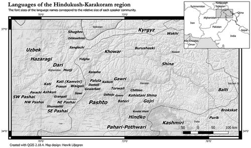
The administrative home of Palula and Kalasha is the southern part of Chitral District in Pakistan’s Khyber Pakhtunkhwa Province. The Chitral District lies in a mountainous region known for its linguistic diversity, as illustrated in Map , comprising Indo-Aryan, Iranian Nuristani, Turkic, Tibeto-Burman languages, as well as the language isolate Burushaski.
4.1. The two languages and their speakers
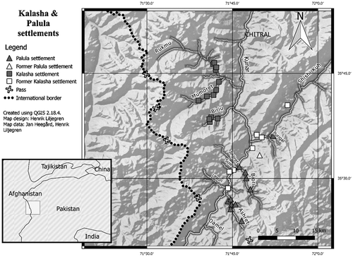
Palula [phl; phal1254] is spoken by an estimated population of 10,000 to the east of the Kunar (or Chitral) River (Map ). The main areas of settlement are the two valleys Ashret (Atshareét) and Biori (Bhiúuṛi) with a population of 6,000 and 3,000, respectively. In Palula villages outside of these two valleys, the language is gradually being replaced by Khowar or Pashto. There are few, relatively insignificant, dialectal differences between Ashret and Biori, relating mainly to the lexicon and phonology (Liljegren Citation2016, 4–6, 28–30). Two other languages closely related to Palula are spoken in the surrounding region: Sawi (or Sauji) in Kunar, Afghanistan, and Kalkoti, in Dir Kohistan. Most of the Palula data for this study is from Ashret.
Kalasha [kls; kala1372] is spoken by 3,000–4,000 people in the valleys Rukmu, Mumoret, Biriu, Jinjiret, and Utsun to the west of the Kunar River. Kalasha has two dialects, Southern Kalasha spoken in the valley Utsun, and Northern Kalasha in the valleys Rukmu, Mumoret, Biriu, and Jinjiret (Heegård Citation2015, 18–19; Heegård and Mørch Citation2017). In Jinjiret and Utsun, Kalasha is being replaced by Khowar and not transmitted to children any longer. The data used for this study is from Northern Kalasha as spoken in Rukmu and Mumoret. There are only minor dialectal differences between these two valleys (Heegård Petersen Citation2015, 18–19).
Multilingualism is widespread in both communities. Most, if not all, children of Palula- and Kalasha-speaking parents grow up with Palula and Kalasha, respectively, as their first language, but in both communities, Khowar (the dominant language in Chitral), and for the Palula also Pashto (the provincial lingua franca), is acquired at an early age by both genders. In addition, Urdu, and to some extent English, is learnt in school.
4.2. The landscape and interaction with landscape
The Hindu Kush mountain range contains some of the world’s highest peaks. This particular landscape has a significant impact on the daily lives of the Palula and Kalasha. Villages are traditionally built along the steep mountain sides with houses on top of each other in order not to take up valuable levelled ground for agriculture. Access to the houses is mainly through steep ladders or narrow paths. Above the villages lie the goat and sheep stables, farther up the mountain sides are evergreen forests used for grazing and gathering of firewood. Transhumance still plays an important role in the ways of life of the Palula and Kalasha as shepherds take flocks of goats and sheep to pastures situated in the high mountains in the extreme ends of the valleys. Beside and below the villages, levelled ground is used for agriculture.
4.3. Genetic relationship and linguistic contact
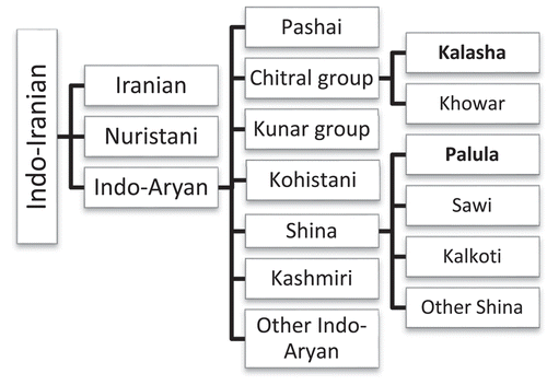
Palula and Kalasha belong to a group of Indo-Aryan languages that have traditionally been termed “Dardic” (see ). It is still a matter of dispute among researchers whether this primarily geography-based denotation has any genetic validity, and we shall refer to these as “Hindu Kush Indo-Aryan languages” (HKIA languages), following Liljegren (Citation2014, 135, Citation2016, 13–16). The internal classification of these languages is also far from settled. According to Strand’s (Citation2001, 258) grouping (basically agreeing with Morgenstierne (Citation1961) and Bashir (Citation2003, 824–825)), Kalasha is in the Chitral Group together with only one other language, Khowar, the main language of Chitral District, while Palula is a Shina variety along with a number of languages spoken in the Kunar Valley in Afghanistan in the west all the way to Kashmir in the east. Within this “Shina” grouping, Palula is held to be one of the most conservative varieties (Morgenstierne Citation1941, 7; Buddruss Citation1967, 11; Liljegren Citation2016, 17–18).
Figure 1. The place of Kalasha and Palula within Indo-Iranian (the internal classification largely follows Bashir (Citation2003, 824–825)).
Palula and Kalasha have not always been “next-door” linguistic neighbours. Historical anthropology (Cacopardo Citation1991; Cacopardo and Cacopardo Citation1991; Cacopardo Citation1991) and linguistic dialectology (Heegård Petersen Citation2015, 18–19; Heegård and Mørch Citation2017) have shown that Kalasha was formerly spoken in a much larger area in Southern Chitral in the villages Lawi, Uzurbekande, and Birga in the Shishi Kuh valley, in hamlets around Drosh in the main Kunar Valley, and in Naghar, Suwir, and Kalkatak along the banks of the Kunar River.
According to local history, ancestors of today’s Palula-speaking population are believed to have migrated from the Indus Valley to the Kunar valley a few centuries ago (Liljegren Citation2016, 10; see also Cacopardo and Cacopardo Citation2001, 84–93). This migration is considered to be the common origin of the Palula-speaking people in Ashret as well as that of the speakers of Sawi. The history of the Palula-speaking people of Biori is less clear, the main Biori genealogies lacking obvious links to those of Ashret. In addition, the ethnic composition of Biori is more complex than that of Ashret (Liljegren Citation2016, 11); there is for instance a local tradition that links a part of the population of Biori with a more recent wave of migration from Dir Kohistan. The latter group, most likely speakers of a Shina variety akin to today’s Kalkoti spoken in Upper Dir, migrated across the mountain passes, settled among an indigenous people, probably of Kalasha origin, in the Biori valley, and gradually their speech converged linguistically with that of neighbouring Ashret, subsequently spreading to settlements in the main valley (Cacopardo and Cacopardo Citation2001; Liljegren Citation2016, 11–13).
A southern Kalasha dialect, for example, as spoken in Kalkatak, and assumingly also in Biori, would then have been in close contact with Palula, perhaps “for centuries” (Liljegren Citation2016, 23). Evidence of contact between a (southern) Kalasha dialect and Palula can, in fact, be found as substratal effects in Palula with a likely Kalasha origin: a velarised /l/-allophone, in the Biori dialect only, and some shared (but exclusive) lexical items: e.g., kir “snow” (cf. Kalasha kírik), prašpíili “perspiration” (cf. southern Kalasha preṣpél); Palula ghróom “village” may also be a loan from Kalasha grom.Footnote4
5. The geomorphic systems in Palula and Kalasha
General locative and other spatial expressions in Palula and Kalasha draw from a number of linguistic resources: (a) case inflection, (b) core-function postpositions, (c) specialised postpositions, and (d) inherently locative expressions (henceforth referred to as relational nouns). In both languages, spatial relationships may be expressed by a combination of these.
The relational nouns in focus in this study are those that are geomorphic, i.e., they encode in their semantics locations or directions in relation to the surrounding landscape.Footnote5 Although in many cases used adverbially (without preposed modifier nouns), these and other relational nouns share some formal features with other nouns, such as the ability to take case marking, or other nominal suffixation, and to combine with postpositions, often in that way specifying movement toward or away from the reference points.
5.1. Shared topographic semantics
Palula and Kalasha both encode (the direction of) the flow of the river and the mountain slopes in their spatial systems. illustrates in a schematic fashion the basic principles of the geomorphic coding common to Palula and Kalasha (but see discussion of the coding of the cross-axes in Kalasha in 5.2.2).
Figure 2. Landscape features encoded in Palula and Kalasha.
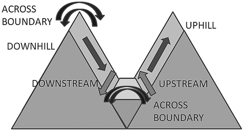
As we shall see, both languages have other lexical and grammatical means than the geomorphic relational nouns for expressing location or direction in the dimensions downstream-upstream, downhill-uphill as well as cross-stream and cross-hill in a systematic way. However, Palula and Kalasha differ with respect to the particular morphosyntax by which this is expressed and with respect to the lexical material recruited. While the slope-based and river-based dimensions are expressed in a systematic and similar fashion in both languages, the cross-dimensions stick out with respect to their morphosyntactic coding. And while Palula verbs emphasise, for example, stream-based motion, Kalasha motion (and other) verbs, emphasise crossing of a barrier.
5.1.1. Geomorphic coding in Palula
As mentioned above, relational nouns are inherently locative expressions. In clauses, they often have adverbial functions.Footnote6 A subset of five such relational nouns relate to prominent environmental features (): huṇḍ “upslope”, bhun “downslope, downstream”, aǰá “upstream”, oóra “this side”, phaár “that (opposite) side”.
Figure 3. Palula relational nouns in relation to slopes and the flow of streams.
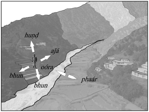
Figure 4. Division of space on the river-based axis.
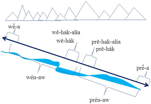
Figure 5. Division of space on the slope-based axis.
Map 1. The mountain region of northern Pakistan and adjacent areas of neighbouring countries. Language names occur in italics. (Map created with QGIS 2.18.4 using data provided under cc by-sa by © OpenStreetMapContributors).
In example (2), the two expression huṇḍ and bhun refer to the relative – and opposite – vertical positions along a slope. While a static location or a goal (bhun in (2)) tends to be coded by the lexical stem alone, a movement from such a position (huṇḍ-íi) is expressed in a case suffix added to the stem. Sometimes the direction is further specified with a postposition, see (6).
Relational nouns can also have the direction of streams as their reference point. This is the case with aǰá, which encodes an upstream location or direction. In (3), the narrator describes how he goes hunting and heads in an upstream direction along one of the many irrigation canals that cut through his village, taking him to the forest.
The relational noun bhun, also, apart from its (perhaps primary) downslope reference, encodes a downstream location, as in example (4), in opposition to aǰá, thus constituting a lexical asymmetry in the system as far as reference to the two axes is concerned.
Two other relational nouns, oóra “here, on this side” and phaár “yonder, over on that side” are used with reference to a physical boundary, usually a stream/gorge or a mountain pass, oóra encoding the viewpoint’s side, as in (5), and phaár the opposite side (6). The terms can also be used in the sense of “what is on my left-hand side” (phaár) and “what is on my right-hand side” (oóra) as one moves down-stream through the Ashret valley on the right-hand side of the gorge from the Lowari pass to Mirkhani (where it meets the main Kunar basin).
It is worth noting that the slope-oriented expressions bhun and huṇḍ (but not the riverine aǰá) also can be used in a more generalised vertical sense without reference to a slope or a hillside per se. The language also displays a number of, mainly adverbial, derivations () based on the geo-coding relational nouns, some of them obviously more productive than others.
Table 1. Geomorphic relational nouns in Palula with attested derivations (B. = Biori dialect).
Contrary to the case of Kalasha (see below), these derived terms are not readily analysed as a further partitioning of the axes in terms of relative distance in Palula. Instead, they mostly elaborate on the speaker’s perspective or the phase of moving into or remaining in a particular spatial position. This, however, is subject to further more detailed investigations, taking more usage data into account.
All adverbial expressions ending in -giroó, -giraá, -(te)giráak, -tráak are likely to be mere (idiolectal or dialectal) variants of a derivation producing a meaning such as “toward X, turning in the direction of X, X-ward” (cf. giraá, the converb of giróo “turn sth (into)”), often emphasising the change into a certain orientation or the initial phase of moving in a certain direction. In (7), the speaker tells about his grandfather who was out walking when suddenly he came upon a sleeping bear lying across the path, and there was no alternative path neither upslope nor downslope that he might take.
In (8), the term aǰagiraá adverbially encodes the upstream direction of the leopard that had just run away. The same type of derivation is also applied to a few non-geomorphic relational nouns, e.g., patu-giraá(k)/patu-giroó/pat-ráak “back, turning back” (< patú “behind”) and muṣṭu-giraá “forward” (< muṣṭú “in front (of)”).
The derivational suffix -(i)maá is distributionally flexible and encodes an ongoing movement or location in the direction specified by the relational noun stem, approximately “(while) in the direction of X” or “the thing located in the direction of X”. In addition, there is a tendency for the derivations with -(i)maá to be used for short, often visible, distances, in contrast to e.g., the use of the derivations with -giraá that are used when referring to longer distances, thus vaguely resembling the Kalasha axis partitioning (see below).
The forms ending in -mooṣṭá are translatable as “the end of X; the X-most” (the noun moóṣṭ meaning “edge, end, part”) with reference to the dimension encoded in the relational noun stem. In (9), aǰamooṣṭá is used attributively as a means of identifying the village referred to in relation to the other villages farther downstream in the Biori valley (the lower-most being referred to as bhunimooṣṭá).
Some of the forms displayed in (huṇḍaṛáa “up there”, bhunaṛáa “down there”, etc.) are the result of relational nouns fused with deictic bases (huṇḍ “up above” + aṛáa “there”), and thereby serving as a further, spatial, refinement of the distal (visible, out of reach) category of the Palula deictic system,Footnote7 occurring pronominally as well as adnominally. An example is displayed in (10).
5.1.2. Geomorphic coding in Kalasha
Like Palula, Kalasha also has a set of diametrical geomorphic relational nouns that indicate location or direction in relation to the slope and to the flow of the river, either upslope or upstream from a reference point, downslope or downstream from a reference point, or across a river or over a mountain pass (Trail and Cooper Citation1999; Heegård Petersen Citation2006, 181–186, Citation2015, 51–52). The inventory of geomorphic adverbs with attested morphological forms is shown in .
Table 2. Geomorphic relational nouns in Kalasha.
In contrast to Palula, expression of location and direction on the cross-axes is asymmetrical as there are no specific geomorphic adverbs for location or direction on the same side as the referent. “Same-side” location or direction of a river or mountain pass is expressed by one of the deictic “here” adverbs, ayá “here-spec”, and- “here-ns” or, if the boundary-nature of the location is emphasised, with anén- “here (cross-boundary)”, as in (11).
While the lexical stems of the geomorphic adverbs partition the landscape along three axes, the morphological combinations partition these axes further, although not in a uniform way as can be seen from the derivational forms in .
The locative suffix -a seems to denote location or direction far away from a reference point (with the geomorphic relational nouns), perhaps also indicating non-visibility or non-accessibility. The diminutive -hák/-ák denotes location or direction close to a referent point, and the adverbialising -aw denotes location or direction unspecified for distance in relation to a reference point. The choice between morphological forms may depend on actual distance, as shown in (12).
The choice between the different suffixes, and consequently denotation of distance, may also depend on perspective rather than actual distance between Figure and reference point.
Also, the specific long-distance location expressed with -a can be paraphrased in a general description. In (13) and (14) the same speaker describes the same location, the Nuristani village Brumbutul, far upriver in Mumoret, first with wẽa, then with the general wénaw.
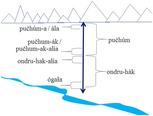
The partition of the slope-based vertical axis is not as systematically coded lexically and morphologically as the partition of the river-based axis. In Heegård’s data there are only examples of the derived forms ondruhák “a little downhill” and óndrua “far downhill”. In contrast, the underived form pučhúm “uphill” is used for an uphill location or direction unspecified for distance, the derived form pučhumák for location or direction a little uphill, and pučhúma for “far uphill”. The latter form, however, seems interchangeable with hála/ála “high (and steep) uphill” without a difference in meaning, both implying location or direction so far up (the slope) that it is not visible any longer. Example (15) describes the location of the spring of the stream, gha, the high location of which is further emphasised by creaky voice in the narration. With pučhúma in (16), the speaker describes that from the high-lying upper part of the mountain in Mumuret, there is a small valley, Gambak, which leads to Biriu (see Map ).
Map 2. Southern Chitral displaying the locations of Kalasha and Palula settlements. (Map created with QGIS 2.18.4 using data provided under cc by-sa by © OpenStreetMapContributors).
The short distance in relation to a reference point indicated by the diminutive -ák is shown in (17) where the speaker describes the direction of a path above the reference point, a house.
Like for the river-based adverbial forms, the slope-based forms may also overlap with respect to distance in relation to a reference point. In (18), from a fable, the main character, a fox, finds himself about to fall asleep at a dangerous, steep place on the mountain side and therefore asks his companion to move just a little “uphill” so that he himself can get to sleep in a safer place.
Undruhák “(a little) downhill” can also denote a downhill direction without specified distance, as in (19), where the speaker describes the location of shops, the road, and the river in the valley.
For location far downhill (and out of sight), similar to the vertical puchúma and hála, only ógala “steep downhill; bottom downhill”, as in (20), is used.
The partition of both axes can be even further refined by the suffix -alía “a little way”, which attaches to the diminutive -hák/-ák forms to denote location or direction at an even shorter distance.
Kalasha’s way of partitioning the river-based and slope-based axes in terms of relative distance is shown in Figures and .
The cross-axes cannot be specified in similar detail by means of morphology. The cross-river adverb occurs only in two morphological forms, peranák “a little way across river” and peranáaw “across river-wards”. The choice between the two may depend on actual distance, but may also be a matter of perspective.
There seem to be even fewer morphological possibilities for specifying the location or direction across a mountain pass. To these authors’ knowledge páyrak “across a mountain” can only occur in this form. This adverb’s actual frequency of use is uncertain. It is not attested in Jan Heegård Petersen’s data. Instead, informants express location or direction across a mountain pass by a construction with the verb bihóṭ- “cross over something”, as in (21).
5.2. Verb semantics
5.2.1. Spatial semantics in Palula motion verbs
Palula motion verbs () are lexically specified for direction or orientation, and in some cases for both.Footnote8 Orientation is often intimately tied to landscape features, reminiscent of the dimensions described above for relational nouns. While yhíi and bíi (both motion verbs that are specified for direction, but neutral as far as orientation is concerned) are the closest equivalents of English “come” and “go”, two other verbs with orientational specifications (but without directional specification), whíi “get down” and ukhíi “get up” are almost equally basic and frequent. Indeed, before the advent of Islam (and probably for a long period after that), Palula speakers greeted each other with an initial Wháatuee? “Didn’t you come down?” if the other person came down from some place up the valley or Ukháatuee? “Didn’t you come up?” if he happened to have ascended from a place farther down the valley.
Table 3. Palula motion verbs and their semantic specifications. The citation forms of the verbs are fut.3sg, following the conventions of Liljegren and Haider (Citation2011).
These verbs can be used for relating to short as well as to long-distance travelling, cf. (22), (23) and (24), all with reference to an upstream/downstream or uphill/downhill movement.
But both ukhíi and whíi can also encode small-scale purely vertical movements such as climbing up or down a tree.Footnote9
However, the fact that these verbs do not merely relate to absolute elevation when used over long distances but are primarily riverine, becomes obvious when e.g., studying the use in (25) of the upward verb ukhíi for talking about the movement carried out while going from Ashret, situated at about 1450 m above sea level, to Drosh, a bazaar town at about 1360 m above sea level in the main Chitral-Kunar valley. The important aspect of that movement is apparently one of travelling in the direction opposite to the flow of the main stream.
The cross-axis traversed when using láanga and phéda is mainly natural boundaries such as mountain passes or streams, just as we noted above concerning the relational nouns oóra and phaár. In (26), Nagar Shah, the (Kalasha) lord of a fortress notices by means of a special device that somebody is about to cross over the moat separating the fortress and the surrounding land.
Similar to what was noted above concerning the use of whíi and ukhíi in greetings, another common way, even today, of greeting or “congratulating” an arriving traveller is by (rhetorically) asking, Tu xéera sangí phedíluee? “Did you arrive [i.e., come across] safely?”, thus implying that the boundary-crossing was indeed successful.
The antonym pair nikhíi-áača is not primarily geomorphic, but can apart from their applications to movements in and out of man-made enclosures – of varying sizes – also refer to a transitioning between narrow passages, caves, forests, on the one hand, and open spaces, fields, on the other, i.e., phenomena in the natural environment. The terms could also be seen as encoding transitions between invisibility (or low visibility) and visibility (high visibility). In (27), the narrow pass leading from the Damel valley through the gorge of Katargha to the Ashret valley is perceived as such an enclosure in contrast to the open space of the Ashret basin.
All four of the main orientation-defined motion verbs in Palula – whíi, ukhíi, láanga, phéda – have morphologically derived causative equivalents. The finite verb langóo in (28) is the causative of láanga.
While spatiality is featured separately and to a varying extent within each of these sub-systems, it should be noted, as already hinted at in the presentation, that some of these mechanisms or resources for expressing spatial features are indeed often combined in Palula, morphologically as well as syntactically.
5.2.2. Spatial semantics in Kalasha motion verbs
In contrast to Palula, Kalasha does not have a specific set of verbs that describe upward or downward motion. The verbs for “climb up” and “climb down”, úṣṭik “climb up; ascend; get up from bed; wake up” and učhundík “climb down; descend”, may be used for describing motion up and down a slope, but there is always an element of manner implied with these verbs, for example overcoming or progressing along a troublesome path. The neutral and most common way of describing motion up and down a slope is with the slope-oriented relational nouns and ondruhák and a motion verb, as in (29).
However, some basic verbs of motion encode another landscape feature in their semantics, namely that of a barrier. Crossing a mountain top or other barrier that leaves someone out of sight is expressed by bihóṭik, as shown in (30). Bihóṭik is neutral with respect to manner, it denotes crossing by foot, by flying, or by a natural gliding motion like the Sun’s motion on the sky.
The “bottom-valley” equivalent to bihotik is wázik, as in (31), which denotes crossing a river, also irrespective of manner, i.e., swimming, by foot through the water, or by foot along a bridge.
In its transitive form, wazék, the verb means “carry across a river”, also irrespective of manner. This is in sharp contrast with how Kalasha requires its speakers to express the manner of carrying when such an event takes place within or not across a barrier: kúɫim kárik “carry in one’s arms”, učhúnyak kárik “carry in upright position against the body” (lit. “bosom do”), aṣ kárik “carry on shoulders” (lit. “shoulder do”), and kúṣki dyek “carry by holding to one’s body” (Trail and Cooper Citation1999).
The semantic parameter “barrier” is also indirectly expressed in other sets of self-motion and caused motion verbs. For example, átik “enter” can be glossed “enter by crossing a barrier” and nihík “go or come out from” as “go out crossing a barrier”. The basic “put” and “take” verbs also indirectly encode placement and removal in relation to a barrier. Thek and uprek mean, respectively, “place on” and “take away from” a surface (and a visible and directly accessible location), and dyek and nihék, respectively, “put in” and “take away” from a container or a hidden place (and a non-visible and not immediately accessible location).
5.3. Summary
The preceding survey has shown that Palula and Kalasha both employ geomorphic relational nouns for denoting slope-based and river-based location. The lexical stems in both sets may be modified by suffixation. In Kalasha this is used for specifying relative distance or a viewer’s perspective on the location or direction in relation to a reference point. This semantic partition by derivational morphology resembles what is seen in Prasun (Budruss and Degener Citation2017, 452–453; see also below). In Palula, in contrast, the derivations seem to indicate change or modification of the speaker’s orientation with respect to the location (Section 5.2.1.) Both languages also code location and direction in relation to a boundary with distinct lexemes, but neither in Palula nor in Kalasha is the cross-axis as “partionable” lexically and morphologically as the mountain-based and river-based axes. In Kalasha, the cross-river dimension seems to be partitioned along the same lines as the mountain- and river-based axes, while the cross-mountain dimension is encoded not by a geomorphic relational noun but with a co-verb construction with the verb bihóṭik “cross something”.
When considering verbal lexemes, both languages highlight motion across a boundary, but while Palula has a dedicated lexical strategy for expressing motion along the river, whíi “downstream” and ukhíi “upstream”, there is no separate and unambiguous lexicalisation of the corresponding slope-based motion. Kalasha speakers prefer constructions with an adverb and general motion verb for both axes, for example pučhúm parík “go uphill”. The verbal systems emphasise boundary-crossing in different ways. Besides an antonym set that denotes motion into and out of an entity, Palula has also developed a set of general verbs for crossing a boundary. In Kalasha, the significance of boundary-crossing is expressed in carry verbs (with annulment of manner differentation when carrying across a river), in put and take verbs and, like Palula, in verbs that denote “enter” and “go out from”.
6. Geomorphic coding in the surrounding Hindu Kush-Karakoram region
While Palula and Kalasha have similar topography-oriented FoR systems as expressed with geomorphic relational nouns, it is noteworthy that they do not seem to share an etymologically related vocabulary or morpheme inventory (except for maybe Palula phaár “other side of boundary” and Kalasha páyran/payrák “across a river/mountain pass”), see Tables and . In addition, we have not been able to detect in either of the languages unambiguous lexico-semantic correspondences with the common Indo-Aryan ancestor language. In our view, this lack of diachronic evidence supports the historical scenario sketched in Section 4.3, according to which a contact situation as a cause of possible mutual linguistic influence between Palula and Kalasha most likely is of a recent date. On the one hand, the similarity in the overall geomorphic systems in Palula and Kalasha therefore indicates adaptation to the surrounding landscape, following Palmer’s prediction. On the other hand, the dissimilarity in the specific morphematic means by which the geomorphic semantics is expressed in the two languages, points in the direction of different histories and contact patterns, in spite of the relatively close genetic relationship.
Considering these tentative indications of contact-induced similarities, it will be necessary to say something about the occurrence of geomorphic features in languages of the surrounding region, as well as for other languages closely related with Palula and Kalasha. Such an investigation, however, suffers from the fact that we only find detailed descriptions of spatial coding for a few languages in this part of the Hindu Kush. Nonetheless, by surveying the available literature, and by stressing the need for further verification and supplementary data for the languages involved, we here propose the existence of two types of systems that relate to spatial, particularly adverbial, expressions: (1) A system that clearly distinguishes a riverine from a slope-based axis; (2) a system that does not make such distinctions, but instead makes general reference to directions up-down without linking it to particular landscape features. In the latter system, there is no singling out of any clear category or sub-category of geomorphic expressions vis-à-vis adverbial expressions in general.Footnote10
The first system is, apart from Kalasha and Palula represented by other languages situated in the central western part of the Hindu Kush (as defined above): Indo-Aryan Dameli and the Nuristani languages Waigali, Kamviri, and Prasun. Dameli has a system reminiscent of Palula with three antonym pairs related to the landscape: oor “near” and phar “far” with reference to a river or valley, and two pairs translatable as “up” vs. “down”: puču vs. bun (cf. Palula bhun); ṣin vs. baar (Perder Citation2013, 162–163). Possibly, one of the pairs relates to the slope and the other to the flow of the river (our interpretation). Waigali, one of the Nuristani languages spoken in the area of Northeastern Afghanistan, i.e., immediately west of the Kalasha-speaking area, has an elaborate set of locational morphemes described by Degener (Citation1998, 95–102) as consisting of three sub-systems, each covering a particular spatial domain, all of them entailing obvious references to the surrounding landscape. One sub-system is primarily stream-oriented, with two opposite terms, war “upstream” and ber “downstream” (cf. Dameli baar and Kalasha wẽ- “upstream” and prẽ- “downstream”). A second sub-system includes at least four pairs of spatial oppositions, mostly signalling slope-related directions or locations, e.g., o “up the slope” vs. wü “down the slope”. In a third sub-system, movements to and from a reference point are encoded in a fine-grained manner, for example, as many as four more fine-tuned vertical differentiations can be made within each of these two oppositions, including movements across physical barriers. In Kamviri, locational morphemes, many of them clearly cognate with the Waigali ones, are used in a similar way, again with reference to general verticality (straight up–down), gravitational flow (upstream–downstream) and in relation to natural barriers (Strand Citation1999). Even more elaborate is the spatial system of Prasun. This is clearly demonstrated in Buddruss and Degener’s (Citation2017, 449–482) careful investigation of geomorphic coding in Prasun. The inventory of locational morphemes encompasses as many as 39 prefixes that can occur either with verbal or deictic bases. A group of these prefixes corresponds directly to the surrounding physical landscape. That is: Prasun speakers seem to have an inner compass that is calibrated on the basis of how the Prasun valley itself is situated. The “up-valley” terms, all beginning with ž-, approximately code the North, the “down-valley” n-terms the South, the “left” w-terms the East, and the “right” s-terms the West, and even locally those, practically speaking, cardinal directions take precedence over the small-scale flow directions. Further, Prasun has a set of derivational morphemes that can partition the downstream axis, clearly reminiscent of what is described for Kalasha.Footnote11
The second system is represented by Khowar, Wakhi, Shina and Kohistani languages, i.e., languages spoken in the eastern or northern parts of the Hindu Kush region. In this system, the axes are clearly conflated, or at the least there is no evidence of any distinctions between riverine references and slope-based ones, even in the case of individual shared cognates between Palula and the other Shina languages. Khowar, Kalasha’s closest relative, uses adverbs with reference to location/motion on a slanted surface with inherently higher vs. lower sides: múɬi “lower, i.e., downhill/downstream” vs. tóri “upper, i.e., uphill/upstream” (roots: múuɬ- “bottom”; tór- “top”; -i is a locative case ending) (Bashir Citation2000, 23–24).Footnote12
Among the Shina languages, the closest relatives of Palula, the Kohistani Shina deictics have óra “(in) this direction, over here” and paár “across, yonder, over there”, obvious cognates of the similar-sounding and similarly used Palula relational nouns (Schmidt and Kohistani Citation2008, 94–95). The directional adverbs húuṇ “up” (cf. Palula huṇḍ “up(slope)”) and kharí “down” probably correspond to the similarly glossed adverbs or relational nouns with riverine or slope reference in some of the other languages, although Schmidt and Kohistani (Citation2008, 213) do not supply any specifics. In Gilgiti Shina, various terms based on the two roots aǰí “up” (cf. Palula aǰá “upstream”) and khirí “down” seem, according to data available to us, to be used in a generic sense, applied equally with reference to small-scale (e.g., object-relative) as well as to large-scale directions, in the latter case without any differentiation between stream or slope-related axes. Finally, Iranian Wakhi, spoken in regions adjacent to Khowar in the north, has a set of prepositions that express various locative relations, most of them with reference to verticality or horizontality. These are also fused with demonstratives, thus forming a complex set of adverbial expressions also encompassing those dimensions (Bashir Citation2009, 831–832).
It is remarkable that it is the languages in the lower Chitral-Nuristan sub-region that display similar geomorphic systems, vis-à-vis other closely related languages as well as languages spoken in otherwise similar alpine environments in other parts of the Hindu Kush-Karakoram region. It is also significant that the Nuristani languages and Kalasha have more elaborate locational and directional systems with obvious – and non-optional – geomorphic references such as rivers/streams, slopes/hills and natural barriers. Palula (and possibly Dameli) can been seen as having adopted similar features, but to a lesser extent, thus reflecting an old affiliation to the (eastern) Shinaite or Kohistani sphere as well as a more recent layer of features acquired in interaction with other (western) communities in lower Chitral and Nuristan.
Apart from the traces of what may have constituted a particularly close relationship between Palula and southern Kalasha (Section 4.3), the entire sub-region of Nuristan and lower Chitral, perhaps extending even into Dir Kohistan, was until well into the nineteenth century part of an important pre-Islamic cultural sphere with Nuristan (previously referred to as Kafiristan), and probably the Kati in particular, as its most prominent centre of influence (Cacopardo and Cacopardo Citation2001, 249–250; Klimburg Citation2008; Jettmar et al. Citation1975, 394). This former contact zone is evidenced in a few linguistic features: retroflex vowels, pronominal kinship suffixes, and bisyndetic contrast marking, clustering in a significant way in these languages, including Nuristani languages, Indo-Aryan Kalasha, and Dameli, and partly extending to Gawarbati and the relative “newcomer” Palula, while mostly excluding Khowar, which is the closest linguistic relative of Kalasha, but whose core speaker community embraced Islam at a much earlier point in history (Heegård and Mørch Citation2004; Di Carlo Citation2011; Liljegren and Svärd Citation2017). Our comparison suggests that some aspects of the geomorphic systems common to Palula and Kalasha ought to be added to that list.
7. Perspectives and discussion
The analysis in Section 5 outlined two very similar systems of geomorphic coding in Palula and Kalasha. In our view, the similarity of these two fulfils Palmer’s prediction that languages spoken in similar topographic environments will tend to have similar systems of absolute spatial reference (Palmer Citation2015, 210). From our examination it is clear that the similarity between the systems of geomorphic coding in Palula and Kalasha is not due to their shared genetic relationship. The lexical means by which the two languages encode aspects of the landscape clearly differ (cf. Tables and ); none of the lexical items can – to our knowledge – be shown to have had a topographic meaning element in the shared ancestor language, Old Indo-Aryan. This indicates a historical scenario in which each language has adapted to the surrounding landscape independently from one another. Since both Palula and Kalasha are relatively closely related Indo-Aryan languages, the different lexical outcome of the linguistic adaptation tells us that it must have occurred at different time periods. In our opinion, the preliminary survey of geomorphic coding in the surrounding languages (Section 6) supports this view.
A relevant question to be asked is of course to what extent Palula and Kalasha are prototypical “alpine languages” in their incorporation of inclination of the mountain side and the flow of a river in the bottom of a valley in their lexicon and grammar. It goes beyond the purpose of this article to fully answer that question, which requires a large-scale typological study, but by teasing out the basic systems and the semantic intricacies, we hope to have made a contribution to such a future enterprise. One of the significant features in the geomorphic coding strategies in both Palula and Kalasha is the fact that the “downslope” dimension is less semantically partitioned than the “upslope” dimension. We may speculate whether this reflects a natural tendency or a locally anchored preference for focusing more on the “up” dimension than the “down dimension” (for speakers of languages that employ geomorphic coding strategies in relation to a slope-based axis).
Another significant feature of the geomorphic coding in Palula and Kalasha is the lexical-grammatical emphasis on boundaries, for example in lexemes meaning “across river” and “across mountain top”. Given that a language’s lexicon and grammar may adapt to their environment, cf. Palmer’s hypothesis, it is not surprising that Palula and Kalasha as a part of their relatively well-developed geomorphic systems also encode the flow of the river and use it as a point of reference, either for location along the river at some point or across the river, i.e., the river as a boundary. However, what is remarkable for these two alpine languages is the fact that “boundary” is a significant and basic feature of other “location-coding” aspects of the lexicon and grammar, such as motion verbs, placement verbs, and, not least, the deictic, non-geomorphic adverbs “here on this side” vs. “there on that side” etc. In our view, this is in line with Palmer’s (Citation2015, 218) observations of the reference system in Florutz German, a language spoken in the Italian Alps, of which he notes that
in addition to projecting out from the mountainside to points of a similar altitude on the opposite side of a river or valley, across also notionally projects through the mountain to a point of comparable altitude in an adjacent valley on the far side of the mountain
Even if we accept that Palmer’s prediction is indeed fulfilled, as laid out above for Kalasha and Palula, we are pressed for an explanation as to why a number of other languages spoken in different parts of the same mountain region (and in strikingly similar topographic environments) do not apply such geomorphic encoding. Instead, riverine and slope-based references are, as far as we have been able to determine, conflated in those other languages, and references are made to viewpoint-relative or intrinsic frames rather than to specific features of the physical environment. This lack (or significantly lower degree) of geomorphic encoding applies even to some of the closest linguistic relatives of Kalasha and Palula respectively. To us this signals a tendency for topographical correspondence to be triggered, re-inforced or perhaps sustained by language contact rather than being entirely unaffected by areal features, thus calling for a slight modification of Palmer’s second prediction, that languages spoken in similar topographic environments will tend to have similar systems of absolute spatial reference, regardless of phylogenetic, areal or typological affiliation (Palmer Citation2015, 210). In our case, this specific type of “alpine” geomorphic coding, including riverine, slope-based, and boundary-related references, goes along with a few other non-related linguistic features clustering significantly in the western (or central) part of the Hindu Kush (as described elsewhere) with Nuristan as its most prominent centre of influence.
Funding
This work is part of the project Language contact and relatedness in the Hindukush region, supported by the Swedish Research Council [grant number 421-2014-631].
Disclosure statement
No potential conflict of interest was reported by the authors.
Notes on contributors
Jan Heegård is an associate professor in Danish studies at University of Copenhagen. His main research interests include Danish as a heritage language, areal-linguistic typology and field linguistics. Jan Heegård has published descriptions of the phonology and grammar of Kalasha since 1998.
Henrik Liljegren is an associate professor in linguistics at Stockholm University. His main research interests are areal-linguistic typology, field linguistics and the languages spoken in the mountainous region of Pakistan and Afghanistan. Prior to his present appointment, he worked for several years with Forum for Language Initiatives, a resource and training centre for the language communities in Pakistan’s mountain region, of which he is one of the co-founders. Apart from carrying out linguistic fieldwork in the Palula community, he has been engaged in revitalization efforts, mentoring language activists from various local communities to collect and organize data, and in building networks between local communities and organisations. He is presently leading a project, supported by the Swedish Research Council, which investigates language contact and relatedness in the Hindukush region.
Notes
1 Levinson (Citation1996, Citation2003), Levinson and Wilkins (Citation2006a) and Li and Gleitman (Citation2002), inter alia, each propose three basic FoRs, relative (or egocentric), intrinsic, and absolute (or geocentric), but they do not agree as to which of the types put forward by O’Meara and Pérez Báez are to be considered examples of which class. For a discussion and an overview of the similarities and differences between these classifications, see O’Meara and Pérez Báez (Citation2011, 3–8).
2 Palmer (Citation2015, 183ff, 210ff) considers a geomorphic system such as a riverine system or a slope-based system as a sub-type of an absolute FoR. See brief discussion below.
3 The grammatical glossing principle conforms to the Leipzig Glossing Rules supplemented with the following abbrevations: a = Actual (past), abs = Absent, acr.bound = Across boundary, ag = Agentive (participle), an = Animate, conj = Conjunction, cntr = Contrastive, dim = Diminutive, dir = Direct, emph = Emphatic, inan = Inanimate, ne = Near, ns = Non-specific, p/f = Present-future, rem = Remote, sep = Separative, spec = Specific.
4 Only very little is known about the variety of Kalasha that was spoken in Kalkatak and in that part of southern Chitral until the 1940s. Wordlists reveal considerable phonological divergence from present-day Northern Kalasha, indicating an old dialectal split (Morgenstierne Citation1973; Heegård and Mørch Citation2017).
5 Due to limitation of space, we ignore in our analysis the “projective” relational nouns and their ability to occur in a near-synonymous meaning with the geomorphic relational nouns, like in Kalasha: dúr-as thár-aw/pučhúm áau “he is above/uphill from the house” (house-obl.sg + above-abl/uphill + is.anim).
6 In Liljegren (Citation2016, 169–174) they are described as “spatial adverbs”.
7 The contrasts expressed in Palula are along the parameters: distance (within reach vs. out of reach), visibility (visible vs. invisible), and emphasis (neutral/without pointing, emphatic/with pointing), see Liljegren (Citation2016, 128–142, 167–169) for details. This type of deictic system has been noted as typical of the Indo-Aryan languages in this region (Bashir Citation2003, 823). Kalasha displays a similar system (See Heegård Petersen Citation2015, 51–52).
8 ṣáača is an item of relatively low frequency, possibly with an added manner of specification similar to “climb”. It is yet to be fully described, but is included here for the sake of completeness. An equivalent orientation-wise specified “downslope” verb seems to be missing in the material, and the downstream as well as the downslope meaning is expressed with whíi.
9 It should be noted that in other examples from the text corpus, the verbs raál bhíi “get/climb up” and náama “get/climb down” instead have been used for the vertical movements up and down a tree.
10 For some of the Kunar languages, e.g., Gawarbati, that are spoken in and around the borderland between Pakistan and Afghanistan, we lack any comparative observations. We also lack comparative data from Pashai and from other Iranian languages, such as Yidgha, Munji and Sanglechi, spoken in the vicinity of Kalasha and Khowar.
11 The data is inconclusive as to whether the language isolate Burushaski should also be included among the languages that make use of this system. The presence of two separate antonym pairs, yáar-yaṭ and qhaṭ-dal, both rendered as “up above” and “down below”, respectively, point in the direction of two axes, one slope-oriented and the other stream-oriented, and a number of inherently locative nouns express adverbial senses in pair-wise spatial opposition to one another, much in the same way as Palula and Kalasha do (Berger Citation1998, 92–94).
12 It also indicates directions (before the introduction of modern-day Urdu-derived lexemes) by means of phrasal expressions meaning “the side of the sun’s setting” (West), “the side of the sun’s rising” (East), “the right(hand) side” (North; used this way by Muslims as they face west for prayers), “the left(hand) side” (South; used for the same reason) (Bashir Citation2000, 27). Similarly derived directionals are widespread in the region, from Pashto nwar xaata “the rising of the sun” (East); nwar prewaata “the going down of the sun”, or məx pə kaaba “face to Kaba [in Mekka]” (West) (Muhammad Kamal Khan, pers. comm.) to Gilgiti Shina (Shakil Ahmad Shakil, pers. comm.).
References
- Bashir, Elena. 2000. “Spatial Representation in Khowar.” In CLS 36: The Main Session, edited by Arika Okrent and John P. Boyle, 15–29. Chicago: Chicago Linguistic Society.
- Bashir, Elena. 2003. “Dardic.” In The Indo-Aryan Languages, edited by George Cardona and Danesh Jain, 818–894. London: Routledge.
- Bashir, Elena. 2009. “Wakhi.” In The Iranian Languages, edited by Gernot Windfuhr, 825–862. London: Routledge.
- Berger, Hermann. 1998. Die Burushaski-Sprache von Hunza und Nager, 1. Grammatik (Neuindische Studien, 13). Wiesbaden: Harrassowitz.
- Buddruss, Georg. 1967. Die Sprache von Sau in Ostafghanistan: Beiträge zur Kenntnis des dardischen Phalûra (Münchener Studien zur Sprachwissenschaft, Beiheft [Supplement] M). Munich: Kitzinger in Kommission.
- Buddruss, Georg and Almuth Degener. 2017. Materialien zur Prasun-Sprache Des Afghanischen Hindukusch: 2. Grammatik. Cambridge, MA: Harvard University Press.
- Burenhult, Niclas, and Stephen C. Levinson. 2008. “Language and Landscape: A Cross-Linguistic Perspective.” Language Sciences 30 (2-3): 135–150. doi:10.1016/j.langsci.2006.12.028.
- Cacopardo, Alberto. 1991. “The Other Kalasha: A Survey of Kalashamun-Speakers in Southern Chitral. Part I: The Eastern Area.” East and West 41 (1): 273–310.
- Cacopardo, Alberto, and Augusto Cacopardo. 1991. “The Other Kalasha. a Survey of Kalashamun-Speakers in Southern Chitral. Part III: Jinjeret Kuh and the Problem of Kalasha Origins.” East and West 42 (3): 333–375.
- Cacopardo, Alberto and Augusto Cacopardo. 2001. Gates of Peristan: History, Religion and Society in the Hindu Kush. Rome: Istituto Italiano per l’Africa e l’Oriente (IsIAO).
- Cacopardo, Augusto. 1991. “The Other Kalasha: A Survey of Kalashamun-Speakers in Southern Chitral. Part II: The Kalasha of Urtsun.” East and West 41 (2): 311–350.
- Carlo, Pierpaolo Di. 2011. “Two Clues of a Former Hindu-Kush Linguistic Area?” In Selected Papers from the International Conference on Language Documentation and Tradition – With a Special Interest in the Kalasha of the Hindu Kush Valleys, Himalayas, edited by Carol Everhard and Elizabeth Mela-Athanasopoulou, 101–114. Thessaloniki: School of English and Department of Theoretical and Applied Linguistics, Aristotle University of Thessaloniki.
- Danziger, Eve. 2010. “Deixis, Gesture, and Cognition in Spatial Frame of Reference Typology.” Studies in Language 34 (1): 167–185.10.1075/sl.34.1
- Degener, Almuth. 1998. Die Sprache von Nisheygram im afghanischen Hindukusch. Wiesbaden: Harrassowitz.
- Heegård Petersen, Jan. 2006. “Local Case-Marking in Kalasha.” PhD thesis, University of Copenhagen.
- Heegård Petersen, Jan. 2015. “Kalasha Texts – With Introductory Grammar.” Acta Linguistica Hafniensia 47 (Sup 1 Travaux du Cercle Linguistique de Copenhague, Vol 35): 1–275.
- Heegård, Jan and Ida Elisabeth Mørch. 2004. “Retroflex Vowels and Other Peculiarities in the Kalasha Sound System.” In Himalayan Languages: Past and Present (Trends in Linguistics. Studies and Monographs, 149), edited by Anju Saxena, 57–76. Berlin: Mouton de Gruyter.
- Heegård, Jan, and Ida Elisabeth Mørch. 2017. “Kalasha Dialects and a Glimpse into the History of the Kalasha Language.” In Usque Ad Radices: Indo-European Studies in Honour of Birgit Anette Olsen, edited by Thomas Olander, et al., 159–174. Copenhagen: Museum Tusculanum Press.
- Jettmar, Karl, Schuyler Jones, and Max Klimburg. 1975. Die Religionen des Hindukusch. Stuttgart: W. Kohlhammer.
- Klimburg, Max. 2008. “Status Imagery of the Kalasha: Some Notes on Cultural Change.” Proceedings of the Third International Hindu Kush Cultural Conference, 129–134. Karachi: Oxford University Press.
- Levinson, Stephen C. 1996. “Frames of Reference and Molyneux’s Question: Crosslinguistic Evidence.” In Language and Space, edited by Paul Bloom, Merrill F. Garrett, Lynn Nadel and Mary A. Peterson, 109–169. Cambridge, MA: MIT Press.
- Levinson, Stephen C. 1998. “Studying Spatial Conceptualization across Cultures: Anthropology and Cognitive Science.” Ethos 26 (1): 7–24. doi:10.1525/eth.1998.26.1.7.
- Levinson, Stephen C. 2003. Space in Language and Cognition: Explorations in Cognitive Diversity. Cambridge: Cambridge University Press.10.1017/CBO9780511613609
- Levinson, Stephen C., and David P. Wilkins, eds. 2006a. Grammars of Space: Explorations in Cognitive Diversity. Cambridge: Cambridge University Press.
- Levinson, Stephen C., and David P. Wilkins. 2006b. “The Background to the Study of the Language of Space.” In Grammars of Space: Explorations in Cognitive Diversity, edited by Stephen C. Levinson and David P. Wilkins, 1–23. Cambridge: Cambridge University Press.10.1017/CBO9780511486753
- Levinson, Stephen C., and David P. Wilkins. 2006c. “Patterns in the Data: Towards a Semantic Typology of Spatial Description.” In Grammars of Space: Explorations in Cognitive Diversity, edited by Stephen C. Levinson and David P. Wilkins, 512–552. Cambridge: Cambridge University Press.10.1017/CBO9780511486753
- Li, Peggy, and Lila Gleitman. 2002. “Turning the Tables: Language and Spatial Reasoning.” Cognition 83 (3): 265–294.10.1016/S0010-0277(02)00009-4
- Liljegren, Henrik. 2014. “A Survey of Alignment Features in the Greater Hindukush with Special References to Indo-Aryan.” In On Diversity and Complexity of Languages Spoken in Europe and North and Central Asia, edited by Pirkko Suihkonen and Lindsay J. Whaley, 133–174. Amsterdam: John Benjamins.
- Liljegren, Henrik. 2016. A Grammar of Palula (Studies in Diversity Linguistics 8). Berlin: Language Science Press.10.26530/OAPEN_611690
- Liljegren, Henrik, and Naseem Haider. 2011. Palula Vocabulary (FLI Language and Culture Series 7). Islamabad: Forum for Language Initiatives.
- Liljegren, Henrik, and Erik Svärd. 2017. “Bisyndetic Contrast Marking in the Hindukush: Additional Evidence of a Historical Contact Zone.” Journal of Language Contact 10 (3): 450–484. doi:10.1163/19552629-01002010.
- Majid, Asifa, Melissa Bowerman, Sotaro Kita, Daniel B. M. Haun, and Stephen C. Levinson. 2004. “Can Language Restructure Cognition? The Case for Space.” Trends in Cognitive Sciences 8 (3): 108–114. doi:10.1016/j.tics.2004.01.003.
- Morgenstierne, Georg. 1941. Notes on Phalura: An Unknown Dardic Language of Chitral. Oslo: Jacob Dybwad (Skrifter utgitt av det Norske Videnskaps-Akademi i Oslo, II. Hist.-Filos. Klasse, 1940, 5).
- Morgenstierne, Georg. 1961. “Dardic and Kāfir Languages”. Encyclopedia of Islam, New Edition, Vol. 2, 138–139. Leiden: Brill.
- Morgenstierne, Georg. 1973. Indo-Iranian Frontier Languages. Vol. 4, the Kalasha Language: Texts and Translations, Vocabulary and Grammar, Appendix (Instituttet for sammenlignende kulturforskning, Serie B, skrifter, 58). Oslo: Universitetsforlaget.
- O’Meara, Carolyn, and Gabriela Pérez Báez. 2011. “Spatial Frames of Reference in Mesoamerican Languages.” Language Sciences 33 (6): 837–852. doi:10.1016/j.langsci.2011.06.013.
- Palmer, Bill. 2002. “Absolute Spatial Reference and the Grammaticalisation of Perceptually Salient Phenomena.” In Representing Space in Oceania: Culture in Language and Mind (Pacific Linguistics, 523), edited by Giovanni Bennardo, 107–157. Canberra: Research School of Pacific and Asian Studies, Australian National University.
- Palmer, Bill. 2015. “Topography in Language.” In Language Structure and Environment: Social, Cultural, and Natural Factors (Cognitive Linguistic Studies in Cultural Contexts, 6), edited by Rik De Busser and Randy J. LaPolla, 179–226. Amsterdam: John Benjamins.
- Pederson, Eric, Eve Danziger, David Wilkins, Stephen Levinson, Sotaro Kita, and Gunter Senft. 1998. “Semantic Typology and Spatial Conceptualization.” Language 74 (3): 557–589. doi:10.1353/lan.1998.0074.
- Perder, Emil. 2013. “A Grammatical Description of Dameli.” PhD diss., Stockholm University.
- Schmidt, Ruth Laila, and Razwal Kohistani. 2008. A Grammar of the Shina Language of Indus Kohistan (Beiträge zur Kenntnis südasiatischer Sprachen und Literaturen, 17). Wiesbaden: Harrassowitz.
- Senft, Gunter, ed. 1997. Referring to Space: Studies in Austronesian and Papuan Languages. Oxford: Clarendon Press.
- Strand, Richard F. 1999. Richard Strand’s Nuristân Site: Lexicons of Kâmviri, Khowar, and Other Hindu-Kush Languages. Accessed January 11, 2017. http://nuristan.info/lngFrameL.html
- Strand, Richard F. 2001. “The Tongues of Peristân. Appendix 1.” In Gates of Peristan: History, Religion and Society in the Hindu Kush, edited by Alberto Cacopardo and Augusto Cacopardo, 251–257. Rome: Istituto Italiano per l’Africa e l’Oriente (IsIAO Reports and Memoirs 5).
- Talmy, Leonard. 2000. Toward a Cognitive Semantics. Cambridge, MA: MIT Press.
- Terrill, Angela, and Niclas Burenhult. 2008. “Orientation as a Strategy of Spatial Reference.” Studies in Language 32 (1): 93–136. doi:10.1075/sl.32.1.05ter.
- Trail, Ronald L., and Gregory R. Cooper. 1999. Kalasha Dictionary: With English and Urdu (Studies in Languages of Northern Pakistan, 7). Islamabad: National Institute of Pakistan Studies and Summer Institute of Linguistics.