Abstract
The spatial economy of South African cities is generally believed to be experiencing selective deconcentration, which may exacerbate social inequality because of the physical disconnection between jobs and population. This paper assesses whether the locational pattern of economic activity across Cape Town is following this trajectory, using data from the Regional Service Council levies between 2001 and 2005. One of the main findings is that the city centre and areas close to the centre have maintained their economic dominance, therefore Cape Town remains a monocentric city. Yet the pattern of recent growth is more dispersed than the prior distribution because suburban nodes have gained a disproportionate share of new activity. In addition, the pattern of recent growth is skewed towards the high-income suburbs and away from the Cape Flats where most of the city's poor live. This uneven growth trajectory may be a source of concern for economic, social and environmental reasons.
1. Introduction
A recent budget policy statement by the South African National Treasury observes that:
South Africa's cities face substantial challenges, owing largely to the pace of economic growth to date and continued migration from the countryside. Informal settlements are growing, and infrastructure bottlenecks and backlogs are widespread. (National Treasury, Citation2010:54)
The neglect of urban economic dynamics may partly reflect the lack of reliable data at the local scale. Academic and professional disciplinary divisions are also relevant, since they produce urban planners and geographers with limited economic expertise, and economists who tend to ignore spatial matters. Research to date has tended to assume that South African cities are exceptional and to neglect comparisons with international trends. In addition, municipal and provincial governments have been less concerned with economic shifts than with the need to address inequities in household services, so there has been little demand for applied research of this kind.
Evidence from casual observation and selective monitoring suggests that most South African cities have experienced some degree of spatial deconcentration and dispersal of formal economic activity over the last two decades (Beall et al., Citation2002; Tomlinson et al., Citation2003; Boraine et al., Citation2006; Pillay et al., Citation2006; SACN, Citation2004, Citation2006, Citation2011; City of Johannesburg, Citation2010). Various explanations have been offered, including business concerns about deteriorating environmental conditions, congestion and poor security in older economic centres, and the preference of property developers for cheap peripheral land with good freeway access. Contemporary spatial planning policies may also have done little to steer investors towards a compact urban form because of a more laissez-faire approach to economic development and lack of influence over public infrastructure investment decisions (Dewar, Citation2000; Todes et al., Citation2000; Berrisford & Kihato, Citation2008; Harrison et al., Citation2008, SACN, 2011).
Cape Town is South Africa's third largest city with a population of approximately 3.7 million and mean incomes slightly above the national average (SACN, 2011).Footnote1 Levels of unemployment and inequality are extremely high by international standards (OECD, Citation2008). Like most South African cities, it has a sprawling, inequitable spatial structure (Besteman, Citation2008; McDonald, Citation2008; City of Cape Town, Citation2009; Parnell & Pieterse, Citation2010; Pieterse, Citation2010). There is a high degree of residential segregation and the major concentrations of the population live some distance from the main employment centres. Applied urban research has tended to focus on where people live, given the visibility of the large townships and the availability of demographic data. Development plans have also focused on the resident population in order to improve the delivery of essential services and housing. Far less attention has been devoted to the economic geography of the city.
The purpose of this paper is to examine the broad spatial pattern of Cape Town's formal economy and to identify the main trends. It is an exploratory exercise, given data limitations, but it is none the less significant for four reasons. First, shifts in business location raise important issues of economic inclusion and social justice. The key question is whether changes in the geography of jobs have improved or worsened access to opportunities for the poor majority of the population living in peripheral settlements (Murray, Citation2008; Naude, Citation2008). Previous research has shown that the spatial mismatch between jobs and population exacerbates unemployment (Rospabe & Selod, Citation2006), but not how conditions are changing.
Second, there are concerns about energy efficiency and resource consumption. The central question here is whether changes in the economy are leading the city into a growth path that will cause long-term environmental damage, higher carbon emissions, greater energy consumption and vulnerability to rising oil prices because of low density, car-oriented development on the urban fringe (Turok & Parnell, Citation2009; SACN, 2011). Alternatively, well-located investment may help to improve environmental resilience and sustainability.
Third, there are issues of productivity and growth at stake, including whether new patterns of investment are tending to reinforce the economic advantages of physical proximity and agglomeration in dense business districts by offering opportunities for learning, sharing and matching resources (World Bank, Citation2009; Glaeser, Citation2011). Alternatively, piecemeal and fragmented development may undermine long-term prosperity by reducing the scope for face-to-face interaction, information spillovers and other forms of relationship between firms.
Fourth, there are issues concerning governance and public finance. Are changes in economic geography threatening the viability of the public transport system by creating more complex and disparate travel patterns? Similarly, are new forms of dispersed private development weakening the financial position of city governments through their demands for additional bulk infrastructure in outlying areas?
The evidence for the paper is drawn from the authors' analysis of business survey data collected regularly for tax purposes between 2001 and 2005 – the Regional Service Council (RSC) levy. To our knowledge, this is the first thorough temporal analysis of the Cape Town spatial economy using this source of administrative data. The structure of the paper is as follows. The next section develops a series of propositions that are used subsequently to interrogate the empirical evidence. The following section outlines the sources and methods of data analysis. Subsequent sections explore the main themes: continuing concentration, selective dispersal, and investor avoidance of low-income areas. The final section draws conclusions and identifies future challenges for spatial economy research.
2. Propositions
The following three propositions about Cape Town's changing spatial economy are derived from the literature on patterns of urban development here and in other South African cities, set within a context of wider international arguments and evidence about the trajectories of contemporary urban economies.
Proposition 1: Deconcentration is the dominant tendency, reflected in the relative and absolute decline of formal economic activity in the city centre.
This proposition stems from arguments about the costs or ‘negative externalities’ caused by the concentration of firms in the centre of the city once they grow beyond a certain size. As cities mature, various centrifugal forces encourage the physical decentralisation and dispersal of activity (Hall & Hay, Citation1980; Van den Berg et al., Citation1982; Turok & Mykhnenko, Citation2007). Firstly, growing concentrations of firms increase the demand for land, which creates space constraints, forces up property rents and deters business occupiers. Secondly, concentration causes infrastructure bottlenecks and congestion in the transport system, which add to business costs. Established centres struggle to upgrade and expand these systems because of the level of disruption to everyday services. Thirdly, the building stock and infrastructure in established centres are older than elsewhere, so they are less efficient and more costly to maintain. Decaying properties in ageing centres may attract more graffiti and crime than bespoke premises built to contemporary specifications in suburban business parks. Fourthly, the growth in car ownership simplifies commuting to outlying employment centres that lack public transport. Improvements in communications technology also reduce the need for face-to-face contact for certain kinds of business transactions and enable more dispersed location patterns (Hall & Pain, Citation2006).
Besides these forces that apply to all cities, there are several specific to South Africa (Tomlinson et al., Citation2003; Harrison et al., Citation2008). The removal of apartheid restrictions on black population movements was followed by sizeable in-migration into city centres and inner-city areas in search of livelihoods. This changed the character of these centres, prompting the relocation of established companies and deterring potential investors (Beall et al., Citation2002; Goga, Citation2003; Beavon, Citation2004; Freund, Citation2010; Rogerson & Rogerson, Citation2010). Lack of government investment in public transport over several decades has resulted in an inferior and unreliable system (SACN, 2011). A backlash against the previous regime of highly prescriptive, rigid physical planning has also resulted in a looser approach to the regulation of development, making it easier to build in outlying areas (Berrisford & Kihato, Citation2008; Harrison et al., Citation2008; Swilling, Citation2010). Enclosed shopping malls, gated business parks and office complexes with advanced surveillance systems have proved attractive to businesses, retailers and middle-income customers.
There are also forces peculiar to Cape Town. The off-centre location of the city centre in relation to the bulk of the city's workforce and consumers, caused by the configuration of the sea and Table Mountain, creates additional inefficiencies, such as traffic congestion because of the constrained freeway network. The city centre also lost more than half its population during the forced removals from District Six, thereby losing a sizeable chunk of consumer demand for its goods and services. Subsequent population recovery has been far less than the original losses (Pirie, Citation2007; Boraine, Citation2010). These disadvantages of the city centre are offset by some major attractions, such as the revitalised Victoria and Alfred Waterfront, the continuing presence of important public institutions, and the role that Cape Town Partnership and the Central City Improvement District have played in improving the environment of the city centre.
Proposition 2: Deconcentration is more pronounced for some economic sectors and functions than for others.
This proposition is a qualified version of the first. The balance between the positive and negative externalities of economic concentration varies depending on the branch of the economy, so there is no standard process of decentralisation. Competition for land and property promotes spatial sorting of different kinds of activity, and the filtering-out or displacement of lower-value uses by higher-order functions. Activities that depend on face-to-face contact with other firms and organisations (such as government) for the exchange of complex information and ideas are more likely to remain in the city centre (Hall & Pain, Citation2006; Glaeser, Citation2011). These include corporate head offices and providers of professional services such as lawyers, accountants, consultants, marketing agencies and design firms.
The activities that are more likely to decentralise to suburban and peripheral locations are routine functions, data processing, call centres, administrative operations and companies that are particularly cost-sensitive or require large amounts of land (e.g. for industrial, warehousing and logistics processes). Smaller, owner-managed firms may also make lifestyle decisions to locate closer to home in order to reduce the burden of long-distance commuting (Turok, Citation2001). Some providers of business services that involve car-borne visits to dispersed customers, such as architects, engineers, quantity surveyors, building contractors and firms that service computers or other office equipment, may also prefer suburban locations.
Proposition 3: Decentralisation is stronger towards some places than others.
This is a further qualification of the first proposition. The outward spread of economic activity as a result of centrifugal forces is uneven and selective. Decentralising activities may cluster into more or less distinct nodes within the outer urban area. Some places become more attractive destinations for investment than others. There is no standard process of dispersal.
There may be various reasons why some places are preferred economic locations, including specific assets that draw investment, such as airports or tourist amenities. It may be that some places get a head start and then gain a cumulative advantage by offering firms some of the attractions of larger agglomerations, such as shared services and infrastructure. Or the locational advantage may be more diffuse, such as a large suburb or segment of the city with high disposable incomes or a highly skilled workforce (Turok, Citation2001; Crankshaw, Citation2008). Conversely, private investment may be deterred from other places by perceptions of high crime or low skill levels.
The second and third propositions have in common the idea that locations specialise in different kinds of activities, resulting in a differentiated spatial economy. This may occur if firms benefit more from industry-specific externalities (localisation economies) than from generic urbanisation economies. For example, the city centre may become a specialised cluster of headquarters and associated professional and financial services. Other economic nodes may develop in secondary locations where property is cheaper and the infrastructure, services and skills cater for the needs of particular sectors. Creative industries (including music, arts, design, advertising and film production) may cluster around particular cultural amenities, entertainment venues or heritage attractions. Science and technology parks may position themselves close to universities, medical centres or other research institutions. Major retail centres may develop close to freeway junctions, where plentiful space is available for car parking and goods deliveries. Similar principles may apply to centres of logistics and warehousing, such as a sea port or airport.
Spatial planning and development policies may reinforce these tendencies in order to separate conflicting land uses, protect an area's amenities, and provide specialised industry support services and infrastructure. Differentiation may also be promoted by business associations representing the interests of local companies, or landlords seeking to enhance their property values. Over time, centres may acquire distinct identities that become self-reinforcing as firms self-select where they locate. This process of ‘concentrated deconcentration’ may cause the urban economic form to change over time from a monocentric arrangement to a more complex, multi-centred or ‘polycentric’ pattern (Turok & Bailey, Citation2004; Hall & Pain, Citation2006). This may or may not benefit the metropolitan area's economic performance, depending on the distance and connectivity between the separate centres, since these affect the strength of the relationships between firms and their access to all the advantages of the agglomeration.
To sum up, it is worth quoting an influential recent review of Cape Town's economy by the Organisation for Economic Cooperation and Development (OECD, 2008). Although it was not based on any original or detailed spatial economic analysis of Cape Town, it reflects a view of the city's trajectory that is widely held by interested observers. Its assessment is consistent with all three propositions outlined above and the economic and social implications it derives are clearly negative:
The evolution of the spatial structure of Cape Town has also resulted in several obstacles to the competitiveness of the area. The functional area … has evolved into a sprawling and low-density multi-nodal city-region characterised by strong spatial fragmentation. This trend is not conducive to inter-firm networks and urbanisation economies and generates a spatial mismatch between employment and housing locations. (OECD, 2008:16)
3. Data sources and methods of analysis
A detailed description of data sources and methods is provided in Appendix A. Briefly, the RSC levy was a business tax paid every month by employers to their metropolitan or district councils to fund bulk services (Bahl & Solomon, Citation2001; Fjeldstad, Citation2004). The size of the levy varied according to company turnover and payroll, and was recorded at their physical location. Consequently, the data provide a useful indication of the scale and distribution of economic activity and employment across each municipal area. The City of Cape Town provided us with access to the electronic records of payments made between January 2000 and June 2006, when the tax was discontinued. After extensive cleaning and verification, the data for 2001 and 2005 were used to analyse the changing geography of the economy by industrial sector, using three indicators of activity – business turnover, payroll and the number of companies.
To obtain as rich an understanding of spatial patterns and trends as possible, we used three levels of spatial analysis, from the fine-grained to the broad-brush (see Appendix B for details). This helped to test the propositions more systematically than using a single spatial aggregation. The three spatial units, termed ‘suburb’, ‘node’ and ‘district’ for the purpose of this study, were as follows:
| 1. | ‘Suburbs’: 547 small areas covering the whole city, including the city centre. | ||||
| 2. | ‘Nodes’: the 23 most important economic centres in the city. | ||||
| 3. | ‘Districts’: 11 larger divisions covering the whole city. | ||||
4. Principal findings
4.1 City centre dominance
shows that of the 23 nodes, the city centre is the dominant economic area in Cape Town by a considerable margin. It remained by far the largest economic centre during the early 2000s, despite growing competition from emerging economic centres such as Century City and Tygervalley, and some prominent examples of business relocation. The city centre node accounted for almost a quarter (24%) of all business turnover in Cape Town in 2005. This was nearly two and a half times the turnover of the second largest node – Bellville (10%). Three other sizeable nodes identified in with over 5% of all turnover in Cape Town were also quite centrally located: Salt River/Paarden Eiland/Maitland, Epping Industria and Pinelands/Mutual Park.
Figure 1: Total turnover, payroll and number of companies for the 23 nodes
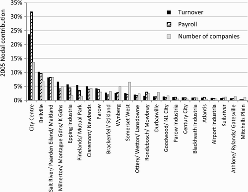
The real scale of economic activity in the city centre is in fact underestimated by the RSC business turnover data because it excludes government services. Considerable public sector activity is located here, including the headquarters of the Western Cape Provincial Government, the City of Cape Town and the national parliament. Their activity is partly reflected in RSC payroll figures as shown in Figure 1. Using payroll as the indicator suggests that the Central City district accommodates almost a third (32%) of all economic activity in Cape Town. Payroll may be a surrogate measure for employment, although city centre salaries are likely to be higher on average than elsewhere because of the disproportionate number of headquarters here. A slightly different picture emerges when the number of companies is examined. The city centre tends to accommodate larger establishments than elsewhere, including corporate headquarters and regional head offices, so Figure 1 shows it has ‘only’ 13% of Cape Town's companies. The average turnover for companies located in the city centre is nearly double that of the city as a whole. Moreover, six of the 10 largest companies (by turnover) in Cape Town, are located in the centre.Footnote2
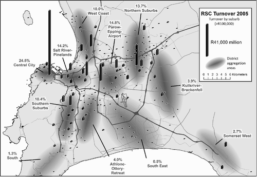
shows the geographical distribution of economic activity across the city using the other two spatial units. The suburbs are represented by the bar graphs and the districts by the shaded areas and the associated numbers. The city centre's dominance over the other suburbs is immediately apparent. This looks very much like a monocentric city with much smaller suburban centres. When the larger districts are used as the basis for comparison, the city centre's strong position is slightly diminished because it is being compared with larger areas of the city, such as the Northern Suburbs and the Parow/Epping/Airport district. Nevertheless its position is still very dominant, with about a quarter of all business turnover being in the city centre.
Figure 2: RSC turnover by suburb and district, 2005
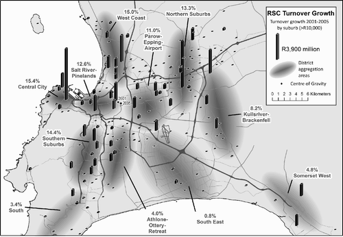
shows the pattern of growth between 2001 and 2005 for the suburbs and districts across the city. The bar graphs represent the absolute growth of turnover for the suburbs and the numbers show the share of the city's total growth secured by each district. The resulting pattern of growth is more evenly balanced than the level of activity shown in Figure 2. Yet the scale of growth in the city centre was still greater than in any other suburb or district of the city. In other words, it retained its dominance despite strong growth in outlying centres in the Northern and Southern Suburbs and the West Coast. Growth in these outlying centres was in addition to, rather than at the expense of, the city centre. The combination of dominant size and strong absolute growth suggests that the central area's status as the city's most important economic centre was not under threat during this period.
Figure 3: RSC turnover growth by suburb and district, 2001–05
Another distinctive feature of the city centre is the density of economic activity, measured by the level of business turnover per hectare. The concentration of high-rise buildings and the relatively small geographical footprint of the city centre results in levels of economic density several times higher than in the secondary economic nodes. Turnover per hectare in 2005 was approximately R400 million in the city centre, R250 million in Claremont/Newlands, and R100 million in Bellville. The city centre is not homogeneous, however. Some areas have very high densities and property values, while others are older, cheaper and less well maintained. This diversity contributes to the centre's sustained attractiveness and resilience to structural economic change. The Waterfront is the most prestigious location, with some of the highest office rentals in the country (Rode & Associates, Citation2007). It has attracted several large companies from older parts of the city centre, including BP Southern Africa and BOE Private Clients, thereby retaining them within the Central City district and staving off decentralisation.
Higher economic and physical densities are also associated with a different composition of activity and high property rentals. Part of the reason for the city centre's success over the last decade has been the growth of high order functions. It has 40% of the city's total turnover in the media sector, including Media 24 (Naspers) and Independent Newspapers Cape. It has 37% of the city's total turnover in the hospitality industry (hotels and restaurants), and 35% of the city's total turnover in the finance and insurance sector, despite the two largest companies, Old Mutual and Sanlam, having their head offices located in outlying nodes (Pinelands/Mutual Park and Bellville respectively). The area also has a long-standing presence in oil company head offices, including Chevron SA, Engen Petroleum and Total SA. Shell SA and BP SA have relocated their head office functions from Cape Town to Gauteng in recent years. The Central City district also accommodates several large retail head offices, including Wooltru, Edcon and New Clicks SA.
4.2 A more dispersed pattern of growth
Growth between 2001 and 2005 was generally spread across a wider area than the prior distribution of activity in 2001 (). Indeed, growth was fairly evenly distributed across the main formal economic districts of the city. This is reflected in the narrow range of turnover growth totals for many of the shaded districts in Figure 3, including Central City, West Coast, Salt River/Pinelands, Parow/Epping/Airport, and Northern and Southern Suburbs. These areas all accommodated between 11% and 15% of total turnover growth in the city.
In addition to the dispersal of economic activity there was also a modest amount of deconcentration taking place. This is apparent in the 10 largest economic centres losing some of their share of activity, while the biggest gains were recorded by suburbs without established economic centres (). These economic gains were apparent across all three indicators – business turnover, payroll and the number of companies. A possible explanation could be that the number of small firms engaged in business or consumer services in residential areas, such as estate agents, accountants, shops, restaurants and guest houses, has increased and the smaller suburban commercial centres have expanded.
Table 1: Scale of economic activity in suburbs of different sizes
Another indicator of change is a shift in the city's ‘economic centre of gravity’. This finding is based on suburb turnover totals and measures the virtual centre of activity in Cape Town. As a result of the growth of outlying centres, the city's economic centre of gravity shifted approximately 500 metres to the south-east between 2001 and 2005 from a location on the north-east side of Pinelands (Figure 3). This was largely a consequence of the collective pull of dispersed growth, as well as the strong growth of Somerset West, on the south-eastern outskirts of the city. This apparent net shift in the location of economic activity towards population concentrations in the south-east of the city may not have improved access to employment opportunities for people living there, because public transport connections to many of the fastest growing economic centres (especially in the Northern Suburbs) are poorer than to the city centre.
4.3 Variations in relative performance
Looked at more closely, there was considerable variation in the performance of the 23 individual economic nodes. In general there was a fairly close correlation between the absolute growth of the node and its size. This can be seen clearly in Figure 4, which contrasts the level of absolute growth between 2001 and 2005 with the size of the node in 2005. There are several outliers worth mentioning in more detail.
Century City experienced unusually strong growth considering its small size. This is because it was started from scratch in the 1990s as a carefully managed mixed-use development on a large, well-located site with considerable upfront investment in infrastructure and landscaping. A basket of development rights was approved, allowing for flexible phasing and developments to be tailored according to changing market conditions (SA Property News, Citation2010).
The northern nodes of Bellville and Milnerton/Montague Gardens/Killarney Gardens experienced strong growth. This mostly involved new development on vacant land. Extensive office and retail development occurred in Tygervalley, which had undeveloped land, good freeway connections and access to the high-income population and skilled labour of the Northern Suburbs. Montague Gardens was designated a light industrial area but has since become an important location for retail, wholesale and business services as well. There was extensive development of vacant sites until around 2007, when the area became effectively fully developed.
Various industrial areas in somewhat peripheral locations have also experienced strong growth. This includes Saxenburg Industria (Blackheath), Airport Industria, Killarney Gardens, Capricorn Business Park (Muizenberg), Westlake (Tokai) and Somerset West. These areas have typically provided affordable sites in attractive, well-maintained and secure business parks oriented towards light industry. In some cases they have been complemented by carefully targeted office, retail and residential developments, suggesting a relaxation of zoning restrictions.
In contrast, the broader Parow/Epping/Airport district experienced relatively weak growth considering the size of the nodes it contains. It includes several older industrial areas and mixed-use areas along Voortrekker Road. The physical environment and infrastructure are more run-down, and lower-value activities such as second-hand motor vehicle retailers are common. Epping Industria was the city's fifth most important node in terms of turnover in 2005. It has large properties and is oriented towards manufacturing and heavy industry. Very little vacant land is now available for business expansion and road congestion is a problem. Road access is crucial to success, but most of Cape Town's stagnating industrial areas have poor road access (Rode & Associates, Citation2007:14). Growth in other industrial areas such as Salt River and Montague Gardens has been boosted by other activities filtering in, but Epping retains its manufacturing character.
4.4 Sector-specific dispersal
Some of the observed dispersal in economic activity appears to have been driven by the decentralisation of space-intensive and lower-value land uses such as manufacturing and back-office functions to more peripheral locations. The evidence for this comes from comparing the spatial growth patterns of different sectors. to 5c show the geography of turnover growth for the three leading branches of the Cape Town economy: manufacturing; finance, business and professional services; and retail and wholesale. Each map shows the distribution of activity in 2005 (the level of business turnover is represented by the size of the circle in each node) and the absolute scale of growth between 2001 and 2005 (represented by the vertical bar in each node). Tables A1 and A2 in Appendix C provide turnover and turnover growth figures for each node for all major Standard Industrial Classification (SIC) divisions.
Manufacturing growth was clearly shifting towards more peripheral locations between 2001 and 2005 (. The main influences here appear to be the availability of affordable land and good access to freeways for transporting material inputs and products. Modern manufacturing premises are increasingly single storey for efficient plant layouts. Lean production processes which require reliable deliveries from suppliers are jeopardised by congested roads. The strong growth of manufacturing in the Central City district appears to have stemmed largely from the media and publishing industry (which is officially classified as manufacturing) and the expansion of administrative offices for manufacturing companies. The node closest to the city centre, Salt River/Paarden Eiland/Maitland, experienced a decline in manufacturing but positive overall growth. Casual observation suggests that manufacturing firms were being replaced by business services and retail uses, often involving the conversion and rehabilitation of old industrial premises.
Finance, business and professional services was the largest and fastest growing sector in Cape Town, accounting for no less than 55% of all absolute turnover growth between 2001 and 2005. Not surprisingly it had the greatest impact on spatial trends. Its growth was concentrated in more central areas than manufacturing. This sector was important in reinforcing the established economic nodes City Centre, Bellville, Century City and Milnerton/Montague Gardens/Killarney Gardens (. Access to labour, customers and transport hubs are important location factors. There was growth in the finance, business and professional services sector in high-income residential suburbs as well as larger economic centres, reflecting the different size and customer base of companies in the sector.
The retail and wholesale sector includes repair services, restaurants and hotels. Its growth was more dispersed than the finance, business and professional services sector, and concentrated more in the north of the city where aggregate household incomes are higher than elsewhere (. Over the last decade, most new high-value residential developments have been in the Northern Suburbs and West Coast, thereby increasing retail thresholds in these districts.
4.5 Lack of activity in the Cape Flats in the south-east
There was a striking absence of formal economic activity in the South East district (the Cape Flats). This district accommodates at least a third of the city's total population (City of Cape Town, Citation2010), yet total turnover and payroll in 2005 amounted to only 0.5% and 0.3% of the city totals respectively. Growth in turnover and payroll between 2001 and 2005 was only marginally higher at 0.8% and 0.9% respectively. This suggests continuing investor avoidance of this area. It is possible that the RSC data underestimate the true level of formal activity in the south-east because of the high proportion of small firms and retail businesses located there. Both groups may be under-represented in the RSC data, as explained in Appendix A. Nevertheless, according to our calculations based on the 2006 City of Cape Town General Valuation, the value of commercial and industrial property in the south-east amounted to only 2.1% of all such property in the city in 2006.
Most activity in the district was concentrated in Mitchells Plain, followed some way behind by Khayelitsha and Philippi East industrial area. Philippi East represented a negligible amount of city turnover in 2005, despite active efforts to promote it as a new economic centre in the 1990s, in line with the Metropolitan Spatial Development Framework of the Cape Metropolitan Council (CMC, Citation1996). Companies in the South East district were also relatively small and unstable. Average company turnover in 2005 was less than a third of the city average. The district also had the lowest proportion of companies existing in 2001 that were still in existence in 2005 (60% compared with 67% for the city as a whole). A more positive finding was the existence of robust growth in areas close by, including Airport Industria, Saxenburg, Lansdowne, Wetton, Ottery and Athlone.
4.6 Growth in high-income suburbs
Most of the economic growth occurred in and around Cape Town's higher-income suburbs. shows the distribution of turnover growth according to the average residential property value of each suburb. All Cape Town suburbs were ranked by average house values using 2006 City of Cape Town valuations. Industrial areas and economic nodes were assigned values based on those of neighbouring residential areas. The majority (79%) of the growth occurred in suburbs with property values above the city average, indicating the polarised nature of economic development across the city. Detailed scrutiny of the data showed unusually strong growth in well-off suburbs such as Somerset West, Westlake, Tokai, Durbanville and Wynberg, especially from small businesses providing professional services (legal, accounting, market research, advertising, management consultancy, architecture and engineering). The share of professional services in total turnover for these five suburbs increased from 9% to 24% between 2001 and 2005, compared with 6% to 15% for the city as a whole.
In addition, economic growth was strong in areas where substantial high-income housing development has taken place. While recent high-income residential development was concentrated in the Northern Suburbs and West Coast, some of Cape Town's most upmarket suburbs are very well established and lack any obvious signs of commercial or residential property development. Local residents here tend to resist attempts to build new housing or to redevelop existing properties at higher densities or for alternative, non-residential uses. To assess the significance of this effect, the relationship between new high-income housing development and business turnover growth was tested using multivariate linear regression. A linear relationship was found between economic growth and the number of new high-value residential properties developed in the area. After adjusting for the size of the economic centre, absolute turnover growth increased by R176 000 for every residential property worth more than R0.5 million developed in the area between 1998 and 2007 ().Footnote3 It appears that new high-income housing development has been promoting localised economic growth. It is unclear whether this is attributable to the growing availability of high level skills, the rising number of consumers with high disposable incomes, the small business owner-managers preference for working closer to home, or some other attribute of upmarket suburban growth.
Table 2: Multivariate linear regression with turnover growth as the dependent variable (R million)
5. Conclusions
The received wisdom is that the spatial economy of South African cities is undergoing a process of selective deconcentration. This is a cause for concern to the extent that it exacerbates unemployment and inequality, undermines economic efficiency and complicates public service delivery. This paper assesses whether the shifting distribution of formal economic activity across the City of Cape Town conforms to three propositions about deconcentration and dispersal (see Section 2 above).
The first main finding relates to the continuing economic dominance of the city centre. Refuting the first proposition, this finding shows that the city centre still accounts for about a quarter or a third of the city's formal economy, depending on how it is measured. Cape Town remains a monocentric city, with a larger scale of activity and more valuable economic functions in the centre than in outlying nodes. The city centre also has a diverse local economy rather than a highly specialised structure, which seems to be a source of strength and resilience.
The second finding is that the pattern of recent growth is more dispersed than the prior distribution. Suburban nodes have gained a disproportionate share of new activity, especially through space intensive, lower-value land uses such as light industry, routine office functions and shopping malls – supporting the second proposition. They have more land available and better access to the freeway network. There is little evidence for industry-specific localisation economies. Older industrial areas with more run-down environments and congested roads are struggling in comparison with newer business parks.
The third finding is that the pattern of recent growth is skewed away from the Cape Flats in the south-east and towards the city's high-income suburbs – supporting the third proposition. It appears that the development of new high-income housing stimulates localised economic growth, especially in the form of small firms providing professional services. The lack of formal industrial and commercial development in the Cape Flats is very striking considering the sizeable resident population. The combined local spending power and labour resources suggest there is unrealised potential for economic growth in the area, especially bearing in mind that the population is growing faster here than elsewhere.
This uneven growth pattern may be cause for concern, particularly for social and environmental reasons, but also perhaps for economic reasons. It may contribute to higher land and property prices in the upmarket areas than would result from a more balanced distribution of activity. It also adds to road congestion, complicates the provision of public transport, exacerbates unemployment, and increases energy consumption and carbon emissions because of the distance between areas of job growth and the majority of the population.
One of the challenges for future research in this field is to disentangle and quantify the costs and benefits of the changing distribution of economic activity across the city. Another is to provide a more complete explanation of Cape Town's spatial economic trajectory through detailed analysis of firms' locational decisions and their outcomes. More detailed research is also required to investigate the existence of localised economic specialisations. A fuller understanding of the costs, causes and dynamics of change is important to inform policies to address the uneven growth pattern and encourage stronger job growth in and around the Cape Flats.
Acknowledgements
The authors wish to thank current and former City of Cape Town officials for assistance with accessing and understanding the RSC data, especially Amanda van Eeden, Winson Bothma and Carol Wright.
Notes
1In this paper ‘Cape Town’ refers to the City of Cape Town administrative area, an area that stretches to Simonstown in the south, Atlantis in the north, Kraaifontein in the north-east and Somerset West in the east, but excluding Stellenbosch, Paarl, Malmesbury and Grabouw.
2The 10 largest companies in Cape Town according to RSC 2005 turnover data in alphabetical order are: ABSA Bank, BP Southern Africa, Chevron, Engen Petroleum, Old Mutual, Pick n Pay Retailers, Sanlam, Shoprite Checkers, Standard Bank and Woolworths.
3The 23 economic nodes were used in the analysis. Growth was based on turnover growth (2001–05) and 2001 turnover was used to adjust for size. The number of new houses was based on district spatial aggregation areas according to their 2006 value using the City of Cape Town general valuation.
Related Research Data
References
- Bahl , R and Solomon , D . 2001 . The Regional Services Council levy: Evaluation and reform options. South Africa Local Government Financial Reform Project, RTI International. http://pdf.usaid.gov/pdf_docs/PNACN048.pdf Accessed 8 September 2010
- Beall , J , Crankshaw , O and Parnell , S . 2002 . Uniting a Divided City: Governance and Social Exclusion in Johannesburg , London : Earthscan .
- Beavon , K . 2004 . Johannesburg: The Making and Shaping of a City , Pretoria : UNISA Press .
- Berrisford , S and Kihato , M . 2008 . “ Local government planning, legal frameworks and regulatory tools: Vital signs? ” . In Consolidating Developmental Local Government: Lessons from the South African Experience , Edited by: Van Donk , M , Swilling , M , Pieterse , E and Parnell , S . Cape Town : University of Cape Town Press .
- Besteman , C . 2008 . Transforming Cape Town , Berkeley : University of California Press .
- Boraine , A . 2010 . “ Central city development strategy ” . In Counter-currents: Experiments in Sustainability in the Cape Town Region , Edited by: Pieterse , E . Cape Town : Jacana Media .
- Boraine , A , Crankshaw , O , Engelbrecht , C , Gotz , G , Mbanga , S , Narsoo , M and Parnell , S . 2006 . The state of South African cities a decade after democracy . Urban Studies , 43 ( 2 ) : 259 – 84 .
- City of Cape Town, 2007. General valuation 2006 – Increased property values do not necessarily mean higher property rate. Statement by Councillor Ian Neilson, Mayoral Committee Member for Finance. City of Cape Town, Cape Town. www.cbn.co.za/press/fullstory.php?newsid=164&office=city_of_cape Accessed 9 September 2010.
- City of Cape Town, 2009. Cape Town Densification Strategy: Technical Report. City of Cape Town, Cape Town. www.capetown.gov.za/en/sdf Accessed 28 July 2010.
- City of Cape Town, 2010. 2007 Population estimates. Strategic Development Information & GIS Department, City of Cape Town, Cape Town.
- City of Johannesburg, 2010. Growth management strategy: Growth trends and development indicators second assessment report. www.joburg.org.za/index.php?option=com_content&view=article&id=3185&catid=61&Itemid=1 Accessed 13 July 2011.
- CMC (Cape Metropolitan Council) . 1996 . Metropolitan Spatial Development Framework: Technical Report , Cape Town : CMC .
- Crankshaw , O . 2008 . Race, space and the post-Fordist spatial order of Johannesburg. Urban Studies . 45 ( 8 ) : 1692 – 711 .
- Dewar , D . 2000 . “ The relevance of the compact city approach: The management of urban growth in South African cities ” . In Compact Cities: Sustainable Urban Forms for Developing Countries , Edited by: Jenks , M and Burgess , R . London : Spon Press .
- Fjeldstad , O-H . 2004 . What's trust got to do with it? Non-payment of service charges in local authorities in South Africa? . Journal of Modern African Studies , 42 : 539 – 62 .
- Freund , B . 2010 . Is there such a thing as a post-apartheid city? . Urban Forum , 21 : 283 – 98 .
- Glaeser , E . 2011 . Triumph of the City , London : Macmillan .
- Goga , S . 2003 . “ Property investors and decentralization: A case of false competition? ” . In Emerging Johannesburg: Perspectives on the Post-Apartheid City , Edited by: Tomlinson , R , Beauregard , R , Bremner , L and Mangcu , X . 71 – 81 . Abingdon : Routledge .
- Hall , P and Hay , D . 1980 . Growth Centres in the European Urban System , London : Heinemann Educational .
- Hall , P and Pain , K . 2006 . The Polycentric Metropolis , London : Earthscan .
- Harrison , P , Todes , A and Watson , V . 2008 . Planning and Transformation: Learning from the Post-Apartheid Experience , Abingdon : Routledge .
- McDonald , D . 2008 . World City Syndrome: Neoliberalism and Inequality in Cape Town , New York : Routledge .
- Murray , M . 2008 . Taming the Disorderly City: The Spatial Landscape of Johannesburg after Apartheid , Ithaca , NY : Cornell University Press .
- National Treasury . 2010 . “ Medium Term Budget Policy Statement ” . In Department of National Treasury Pretoria
- Naude , W . 2008 . Is there a spatial mismatch in South Africa's metropolitan labour market? . Cities , 25 : 268 – 76 .
- NPC (National Planning Commission) . 2011 . Diagnostic Overview , Pretoria : The Presidency .
- OECD (Organisation for Economic Cooperation and Development) . 2008 . Territorial Review: Cape Town , Paris : OECD .
- Parnell , S and Pieterse , E . 2010 . The right to the city: Institutional imperatives of a developmental state . International Journal of Urban and Regional Research , 34 ( 1 ) : 146 – 62 .
- Pieterse , E . 2010 . Counter-currents: Experiments in Sustainability in the Cape Town Region , Edited by: Pieterse , E . Cape Town : Jacana Media .
- Pillay , U , Tomlinson , R and Du Toit , J . 2006 . Democracy and Delivery: Urban Policy in South Africa , Edited by: Pillay , U , Tomlinson , R and Du Toit , J . Cape Town : HSRC (Human Sciences Research Council) Press .
- Pirie , G . 2007 . Reanimating a comatose goddess: Reconfiguring central Cape Town . Urban Forum , 18 : 125 – 51 .
- Quantec, n.d. Quantec Data. Quantec Research (Pty) Ltd, Pretoria. www.quantec.co.za Accessed October 2010.
- Rode & Associates . 2007 . Rode's Growth Points 2007/8 , Cape Town : Rode Publications .
- Rogerson , C and Rogerson , J . 2010 . Improving the local business environment in Johannesburg . Development Southern Africa , 27 ( 4 ) : 577 – 93 .
- Rospabe , S and Selod , H . 2006 . “ Does city structure cause unemployment? The case of Cape Town ” . In Poverty and Policy in Post-Apartheid South Africa , Edited by: Bhorat , H and Kanbur , R . 262 – 87 . Cape Town : HSRC (Human Sciences Research Council) Press .
- SACN (South African Cities Network) . 2004 . State of the Cities Report 2004 , Johannesburg : SACN .
- SACN (South African Cities Network) . 2006 . State of the Cities Report 2006 , Johannesburg : SACN .
- SACN (South African Cities Network) . 2011 . Towards Resilient Cities: State of the Cities Report 2011 , Johannesburg : SACN .
- SA Property News, 2010. Development constraints will push up prices. www.sapropertynews.com/development-constraints-will-push-up-prices Accessed 10 October 2010.
- Stats SA (Statistics South Africa) . 2006 . Labour Force Survey September 2005 , Pretoria : Stats SA .
- Swilling , M . 2010 . “ Dealing with sustainability ” . In Counter-currents: Experiments in Sustainability in the Cape Town Region , Edited by: Pieterse , E . Cape Town : Jacana Media .
- Todes , A , Dominik , T and Hindson , D . 2000 . “ From fragmentation to compaction? The case of Durban, South Africa ” . In Compact Cities: Sustainable Urban Forms for Developing Countries , Edited by: Jenks , M and Burgess , R . London : Spon Press .
- Tomlinson , R , Beauregard , R , Bremner , L and Mangcu , X . 2003 . Emerging Johannesburg: Perspectives on the Post-Apartheid City , Edited by: Tomlinson , R , Beauregard , R , Bremner , L and Mangcu , X . Abingdon : Routledge .
- Turok , I . 2001 . Persistent polarisation post-apartheid? Progress towards urban integration in Cape Town . Urban Studies , 38 ( 13 ) : 2349 – 77 .
- Turok , I and Bailey , N . 2004 . The theory of polynuclear urban regions and its application to Central Scotland . European Planning Studies , 12 ( 3 ) : 371 – 89 .
- Turok , I and Mykhnenko , V . 2007 . The Trajectories of European Cities, 1960–2005 . Cities , 24 ( 3 ) : 165 – 82 .
- Turok , I and Parnell , S . 2009 . Reshaping cities, rebuilding nations: The role of national urban policies . Urban Forum , 20 ( 2 ) : 157 – 74 .
- Van den Berg , L , Drewett , R , Klaassen , L H , Rossi , A and Vijverberg , C HT . 1982 . Urban Europe: A Study of Growth and Decline , Oxford : Pergamon .
- World Bank . 2009 . World Development Report 2009: Shaping Economic Geography , Washington , DC : World Bank .
Appendix A. Data sources and methods
The RSC levy data provide a unique opportunity to analyse economic change at the small area level. No other detailed workplace-based data are available at below the municipal scale. The RSC data make it possible to quantify economic activity by industrial sector in terms of business turnover, payroll, number of companies and new openings and closures. Company addresses make it possible to disaggregate the data at suburb level. The complete dataset is available electronically for all levy-paying companies in the city. The total number of records increased from 40 379 in December 2000 to 48 490 in June 2006, when the levy was discontinued by national government. This was a period of steady economic growth and strong property price rises. One would expect this to be associated with business relocation. Cape Town's Gross Value Added (GVA) is estimated to have grown by 4.8% a year during this period and the total value of all property on the City's valuation roll increased from R195 billion in January 2000 to R654 billion in July 2006 (City of Cape Town, Citation2007).
Some gaps and inaccuracies in the RSC data are worth bearing in mind. The informal sector is excluded. In addition, tax evasion through non-registration is believed by administrators to have been common among small formal enterprises, although this would have been limited by the RSC registration being linked to the South African Revenue Services VAT registration processes, as this provides a financial incentive for RSC registration. Under-assessment may have happened because local authorities had limited powers to question levy assessments (Bahl & Solomon, Citation2001). National and provincial government paid the payroll levy but not the turnover levy, and the city council was exempt from both.
The actual location of business activity may not always be accurate, especially for companies with multiple branches. The head office was typically listed as the physical address, with no records for the branches. In addition, a few companies with branches in Cape Town listed a head office address elsewhere. However, from careful analysis of the data it appears that these limitations had little effect on the overall patterns (see below). Franchises were unaffected because each was independent and responsible for its own levy payments.
Levy payments were recorded in a database maintained by the City Council's Finance Department. This does not allow historical data to be extracted, but copies were made on a monthly basis from 2000 to 2006 as part of a City Council research programme. These datasets were linked with additional information and now constitute a historical record of levy payments. Datasets are available for every December from 2000 to 2005 and for June 2006. The data include information on company name, ownership, physical address, property number, turnover, payroll, employment, company status and economic sector (five-digit SIC code).
Method of analysis
The December 2001 and December 2005 datasets were selected for the analysis for several reasons. Although the intention was to include the longest possible time span, the address data in the earliest dataset (December 2000) were incomplete and the last dataset (June 2006) was from a different time of year, hence vulnerable to seasonality. Time series analysis of the turnover and payroll totals from all seven datasets showed that the 2001 and 2005 totals were consistent with general growth trends. The 2002 and 2004 totals were relatively low and appeared to be outliers, and company records were missing from the 2004 dataset. The total number of active businesses in the 2005 dataset was compared with the Finance Department's original database and found to be consistent, which supported its reliability.
Suburb totals for three indicators of activity were generated: turnover, payroll and number of businesses. As far as possible all three were considered in the analysis to allow for cross-referencing. The final analysis generally focused on turnover data as they provided more plausible results at suburb level than payroll data, which were affected by inconsistent reporting by large public bodies. The 2005 dataset was used to analyse spatial patterns, and temporal changes were based on comparing 2001 with 2005. Suburb totals for turnover and payroll in 2001 were converted to 2005 prices to exclude the effects of inflation. Turnover, payroll, company status and economic sector data were found to be correctly captured and close to 100% complete. Employment figures were not used as they were incomplete and often not updated after 2001.
Company status information seemed to be inaccurate as almost 40% of all ‘active’ companies were found to have zero values for both turnover and payroll. This is supported by Bahl & Solomon's (2001) observation that procedures for identifying companies that had closed were ineffective. To overcome this problem, the number of businesses was defined as the number of records with an active company status and either payroll or turnover greater than zero.
Linking data to geographic location
Company records were spatially linked to a GIS layer using suburb name from the company's physical address. This was done separately for the 2001 and 2005 datasets to capture company relocations between these years. This required data cleaning in order to match RSC suburb names to GIS suburbs. Other options were to use postal codes or property numbers from the Surveyor General 21-digit codes. Postal code data were both clean and mostly complete but provided low spatial resolution. Property numbers allow for very high spatial resolution, but are incomplete. While the 2001 suburbs were less clean than 2005, we attempted to clean both years to the same degree. Each year was progressively cleaned until the largest non-matching suburb name grouping accounted by value for less than 0.01% of total turnover and payroll.
High percentages of RSC records were ultimately matched to the GIS layer (96.7% of 2001 and 96.1% of 2005 records). This accounted for 95.9% and 95.4% of total turnover and 92.0% and 94.1% of total payroll for 2001 and 2005 respectively. Non-matching data were excluded from the spatial analysis. These were mostly companies with head office addresses outside Cape Town, which were estimated to account for 3% of total 2005 turnover.
RSC records were linked to nearly 300 suburbs in the GIS layer thus affording a high level of spatial resolution for a city-wide analysis. However, listed suburb addresses were not always technically correct. In some cases a better-known neighbouring suburb or a broader area than the official suburb was listed (e.g. Bellville rather than Bellville South). In these cases company records were assigned to a central suburb within the broad area. These 300 suburbs were then aggregated into larger geographical areas – 11 ‘districts’ and 23 ‘nodes’.
Dealing with outliers and data errors
Turnover, payroll and company sector data fields were checked for outliers and errors. A total of 84 records were either corrected or dropped from the analysis. Records were scanned for company sector errors and a total of 46 corrections, verified where necessary by internet searches, were made to a two-digit SIC code level of accuracy. The community, social and personal services sector was checked in greater detail as errors were more common in data from government bodies.
Outliers and errors in turnover and payroll were identified as follows. The 2001 and 2005 datasets were linked by company identification number, resulting in a database of 63 874 individual firms. Turnover-payroll ratios were calculated for both years and growth ratios from 2001 to 2005 were calculated for both turnover and payroll for each company. These four ratios were then used to identify inconsistencies. As an additional check, data were summarised by both one-digit SIC codes categories and node spatial aggregation areas and implausible changes between 2001 and 2005 were reviewed. Finally, companies that contributed more than 0.5% to either total turnover or payroll for either year, or to growth between 2001 and 2005, were scanned for errors.
Outliers were dealt with as follows. Where possible, questionable values were replaced with an estimated value based on growth trends of the individual company according to turnover and payroll values drawn from all seven available datasets (December 2000 to June 2006). 2001 or 2005 values were often outliers relative to values from other years. Many of these were almost exactly a factor of 10 or 100 of a more plausible result, suggesting a data-capturing error. In cases where no clear growth trend was evident, the 2005 figures were replaced with an average of values from all years and the record was excluded from the growth calculation.
Adjustments were made on a different basis for two large companies. Turnover growth figures for a large insurance company were replaced with a sector estimate sourced from Quantec Data, Quantec Research (Pty) Ltd, Pretoria. In the other case, a large oil company, Chevron, with both a head office in the CBD and an oil refinery in Milnerton, was split into two records, apportioned by staff location, to reflect the different location of its wholesale and manufacturing activities.
Impact of head office location
Sensitivity analysis was used to assess the effect of distortions introduced by linking companies with multiple branches to their head office addresses. The analysis was repeated with these companies excluded to compare the results. Companies with multiple branches were identified by searching against a list of such firms compiled from Johannesburg Stock Exchange listed companies, tenants of major retail centres and major banks and retail chains. All records with turnover or payroll values greater than 0.5% of the city total for either 2001 or 2005 were also scanned. Companies with activities that do not take place at a specific location were also identified. This yielded 65 businesses that accounted for 9.6% and 18.5% of total city 2005 turnover and payroll respectively. The higher payroll figure was the result of excluding several large government agency head offices.
This had a limited impact on the overall findings, as can be seen in . The city centre, with the largest number of head offices, declined from 23.7% of all city 2005 turnover to 20.9% after excluding companies with multiple branches. It remained much larger than Bellville (10.8%). Similarly, city centre turnover growth declined from 14.2% to 12.7% of the city-wide total between 2001 and 2005. The node with the largest decline was Parow, following the exclusion of Foschini and PEP Clothing head offices. Companies with multiple branches still accounted for 34% of city-wide turnover for the retail sector and 61% for the banking sector. Hence the reliability of the results for these sectors may be affected.
Data validation
The cleaned database was compared with other economic data sources for the city in order to assess its overall reliability. The bar graphs in show the sectoral breakdown of the RSC data compared with that of Quantec 2005 GVA data and the 2005 Labour Force Survey data (Stats SA, Citation2006). The markers in Figure A2 compare real average annual RSC growth rates to those of Quantec for the same period for the total city economy as well as the three dominant sectors. Average annual RSC turnover and payroll growth were calculated to be 6.1% and 5.5% respectively. This is broadly comparable to the Quantec data GVA estimate of 4.8% per annum for this period. The sectoral distribution and growth pattern were also similar to those of the 2005 Labour Force Survey and Quantec estimates except for the commerce sector turnover contribution and growth in the finance sector, where Quantec had a lower growth estimate. The former may be explained by Quantec's use of GVA compared to RSC turnover, which are likely to differ for retail and wholesale. This indicates that the RSC results are plausible and roughly comparable to those of other data sources, thus supporting the credibility of the cleaned RSC data.
Appendix B. Spatial aggregation areas
The ‘node’ and ‘district’ spatial aggregation areas used for this analysis consist of various groupings of ‘suburbs’. This appendix details how nodes and districts were spatially defined. Node and district names are in italics. Suburbs included in the area but not already part of the node or district name are listed in brackets.
List of 23 nodes (, and 5a to 5c; and )
Figure 4: 2005 turnover and growth in turnover (2001–05), R million (2005 prices)
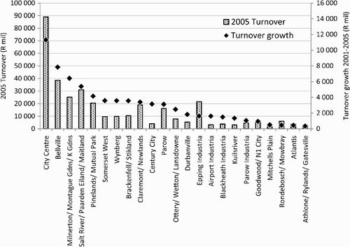
Figure 5: Turnover (2005) and turnover growth (2001–05): a. SIC 3 (Manufacturing). b. SIC 8 (Finance and business services). c. SIC 6 (Retail and wholesale)
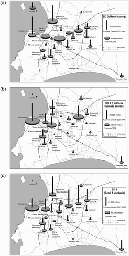
Figure 6: Growth in turnover (2001–05) by suburbs ranked by average house value
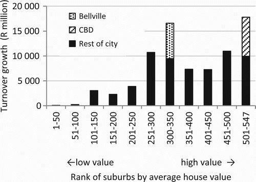
Figure A1: Comparison of 2005 turnover and growth in turnover with and without companies with multiple branches
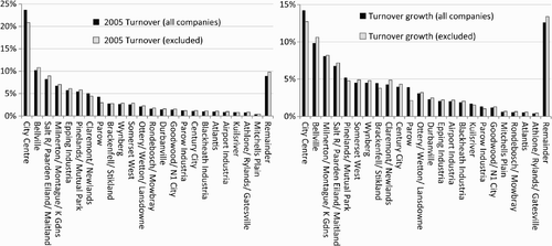
Figure A2: Sectoral contribution and average annual growth comparisons (growth shown only for dominant sectors)
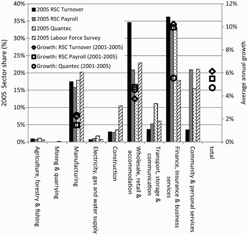
Table A1: 2005 turnover totals for nodes by SIC (R million 2005 prices)
Table A2: Turnover growth (2001–05) for nodes by SIC (R million 2005 prices)
(1) Airport Industria. (2) Athlone/Rylands/Gatesville (Athlone Industria 1 & 2). (3) Atlantis (Atlantis Industria). (4) Bellville (Bellville CBD, Bellville South, Sanlamhof, Saxon Industria, Triangle Farm, Tygervalley, Tygervalley Waterfront). (5) Blackheath Industria (Saxenburg). (6) Brackenfell/Stikland (Brackenfell Central, Brackenfell Industria, Stikland Industria). (7) Century City. (8) City Centre (Gardens, Green Point, V&A Waterfront, Granger Bay). (9) Claremont/Newlands. (10) Durbanville. (11) Epping Industria (Epping Industria I & II). (12) Goodwood/N1 City (Goodwood Estate, Goodwood Extention I, Vasco Estate). (13) Kuilsriver. (14) Milnerton/Montague Gardens/Killarney Gardens. (15) Mitchells Plain (Beacon Valley, Eastridge, Lentegeur, Mitchells Plain Town Centre, Portland, Rocklands, Tafelsig, Weltevreden Valley, Westridge, Woodlands). (16) Ottery/Wetton/Lansdowne. (17) Pinelands/Mutual Park. (18) Parow Industria. (19) Parow (Beaconvale, Parow East, Parow Valley). (20) Rondebosch/Mowbray (Rosebank). (21) Salt River/Paarden Eiland/Maitland (Brooklyn, Metro Industrial Township, Ndabeni, Observatory, Woodstock). (22) Somerset West (Gordons Bay, Strand). (23) Wynberg (Diepriver, Kenilworth, Plumstead).
List of 11 districts ( and – only suburbs with significant RSC turnover are listed in brackets)
(1) Athlone/Ottery/Retreat (Lansdowne, Wetton, Philippi, Athlone Industria 1 and 2, Rylands, Steenberg, Grassy Park, Gatesville). (2) Central City (Cape Town City Centre, V&A Waterfront, Granger Bay, Gardens, Green Point, Sea Point, Camps Bay, Mouille Point, Three Anchor Bay, Tamboerskloof, Bantry Bay). (3) Kuilsriver/Brackenfell (Brackenfell Central, Blackheath Industria, Brackenfell Industria, Eersterivier, Kraaifontein Industria, Saxenburg, Scottsdene, Sarepta, Morgenster, Highbury). (4) Northern Suburbs (Bellville CBD, Sanlamhof, Durbanville, Stikland Industria, Bellville South, Tygervalley, Panorama, Kraaifontein, Plattekloof, Welgemoed, Joostenbergvlakte Smallholdings, Tygerberg Hospital, Tygervalley Waterfront, Triangle Farm). (5) Parow/Epping/Airport (Epping Industria, Parow Industria, Goodwood Estate, Airport Industria, Parow East, Elsies River, Beaconvale, Parow Valley, N1city). (6) Salt River/Pinelands (Old Mutual, Paarden Eiland, Maitland, Woodstock, Observatory, Ndabeni, Cape Town Port, Metro Industrial Township). (7) Somerset West (Strand, Gordons Bay, Firgrove, Macassar, Sir Lowrys Pass, Faure). (8) South (Tokai, Fish Hoek, Kommetjie, Lakeside, Westlake, Noordhoek, Muizenberg, Kirstenhof, Simon's Town, Sunvalley). (9) South East (Cape Flats) (Mitchells Plain Town Centre, Lentegeur, Delft, Khayelitsha, Beacon Valley, Nyanga, Guguletu, Woodlands, Westridge, Eastridge, Philippi East). (10) Southern Suburbs (Claremont, Newlands, Rondebosch, Diepriver, Wynberg, Mowbray, Kenilworth, Constantia, Plumstead, Hout Bay, Bergvliet, Rosebank). (11) West Coast (Montague Gardens, Milnerton, Century City, Atlantis, Killarney Gardens, Table View, Koeberg, Atlantis Industria, Melkbosstrand, Edgemead, Parklands).
Appendix C. Tables A1 and A2
Note: Major SIC (Standard Industrial Classification) divisions: SIC 1: Agriculture, hunting, forestry and fishing; SIC 2: Mining and quarrying; SIC 3: Manufacturing; SIC 4: Electricity, gas and water supply; SIC 5: Construction; SIC 6: Wholesale and retail trade; repair of motor vehicles, motor cycles and personal and household goods; hotels and restaurants; SIC 7: Transport, storage and communication; SIC 8: Financial intermediation, insurance, real estate and business services; SIC 9: Community, social and personal services.