Abstract
While Canada is exposed to a variety of natural hazards, most risk and emergency managers presently lack the necessary tools and guidance to adequately undertake rigorous risk assessments. Recently, Natural Resources Canada (NRCan) has adopted Hazus, a standardized methodology for estimating potential losses from natural hazards developed by the US Federal Emergency Management Agency (FEMA, fema.gov/hazus) as one of the best practice methods for risk assessment. Hazus estimates potential losses from earthquakes, floods and hurricanes, and includes a hazard and inventory database needed to conduct baseline risk assessment studies. An agreement has been signed with FEMA to adapt and co-develop a harmonized North American version of the Hazus methodology. At the same time, collaboration has been initiated within the federal government between the departments of Natural Resources, Environment, Defence and Public Safety to promote widespread usage of Hazus among the full range of Canadian decision-makers. This article reports the typical features of the Canadian version of the Hazus flood module and summarizes ongoing activities and potential challenges in implementing this model in Canada.
Bien que le Canada soit exposè à une variètè de risques naturels, la plupart des gestionnaires de risques et d’urgence n’ont actuellement pas les outils nècessaires et les conseils pour bien entreprendre des èvaluations rigoureuses des risques. Rècemment, Ressources naturelles Canada (RNCan) a adoptè Hazus, une mèthodologie standardisèe pour estimer les pertes potentielles liès aux alèas naturels mis au point par la US Federal Emergency Management Agency (FEMA,fema.gov/Hazus), comme l’une des meilleures mèthodes de pratiques pour l’èvaluation du risques. Hazus estime les pertes lièes aux tremblements de terre, aux inondations et aux ouragans, et comprend une base de donnèes inventoriant les alèas essentiels nècessaires pour mener des ètudes prèliminaires d’èvaluation du risque. Un accord a ètè signè avec la FEMA pour adapter et pour co-dèvelopper une version harmonisèe nord-amèricaine de la mèthodologie Hazus. En même temps, la collaboration a ètè initièe au sein du gouvernement fèdèral entre les ministères des Ressources naturelles, de l’Environnement, de la Dèfense et de la Sècuritè publique pour promouvoir l’utilisation gènèralisèe de Hazus parmi l’ensemble des dècideurs canadiens. Cet article prèsente les caractèristiques typiques de la version canadienne du modèle Flood Hazus et reprend les activitès en cours et les dèfis potentiels à la mise en œuvre de ce modèle au Canada.
Introduction
In Canada, disastrous severe weather and geological hazards take place every single year. They continuously shape our landscape and have profound effects on the economic wellbeing, safety and security of millions of people. Some of these processes have even accelerated in recent years as the frequency of climate-related recurring phenomena, their severity and their destructive effects seem to be increasing (Lemmen et al. Citation2008). A list of the most significant natural disasters in Canada that have resulted in considerable damage, displaced households, injuries and/or fatalities are given in Figure . The extreme flood event is the single most frequent natural hazard responsible for the highest economic and social losses since the beginning of the twentieth century. Flooding has resulted directly and indirectly in the deaths of at least 198 people and several billion dollars of damage during the twentieth century. Although floods can occur any time, most floods occur in spring when several common flood mechanisms such as snowmelt runoff, storm rainfall and ice jams are likely to take place concurrently, thereby increasing the likelihood of high water flows (Government of Canada Citation2003).
Figure 1 (a) Natural disasters in Canada since 1900; (b) frequency of flood disasters [Public Safety Canada (PSC) 2010].
![Figure 1 (a) Natural disasters in Canada since 1900; (b) frequency of flood disasters [Public Safety Canada (PSC) 2010].](/cms/asset/29647890-582a-41b2-a1cd-be7fea68fddf/tcwr_a_801599_f0001_b.gif)
From the 287 major flood events inventoried between 1900 and 2012, 177 or 62% have occurred in four provinces: Ontario (53 events), New Brunswick (34), Quebec (34) and Manitoba (56). The number of flood events has steadily increased through the twentieth century with about 80% occurring after 1970 (Figure b). This trend likely reflects several factors, perhaps most notably the shift in climate, although in recent decades there has been a rapid increase in the development of flood-prone areas due to population growth, and more accurate reporting of flood consequences was recognized (Ashmore and Church Citation2001). In the 1990s, severe flooding in the Saguenay region in Quebec (1996) and Manitoba’s Red River Valley (1997) were the two costliest natural disasters in Canadian history, with direct economic losses of $800M and $150M respectively (Ashmore and Church 2001; Brooks et al. Citation2001). The Saguenay floods alone caused 10 deaths and destroyed more than 2600 households. More recently, the 2011 Richelieu River floods in Quebec caused damages to some 3000 households and commercial buildings, and inundated more than 6000 ha of agricultural lands.
Risk assessment
If not adequately addressed, the loss of life and property due to natural hazards can be enormous. While Canada is exposed to a variety of natural hazards, conventional knowledge of the hazard information alone such as type, intensity and frequency is not sufficient for informed decision-making. Mitigation and emergency response measures need to be tailored with respect to the natural hazard in question, but also to take into account the affected people and assets, their respective vulnerabilities and the adaptation and resilience capacity of the communities and governments. Proper pre-disaster planning and preparedness will not only save human lives but will also reduce the negative impacts of hazards in general. Natural hazard risk assessment is thus central to risk reduction as well as to the emergency management planning process.
Risk assessment is the process of measuring impacts resulting from natural hazards in terms of likelihood and consequences. It is estimated as a combination of hazard, exposure and respective vulnerability where hazard is a measure of the probability of a given intensity of a naturally occurring phenomenon that may pose a threat over a given geographic extent and time period; exposure (or inventory) refers to the elements at risk, i.e., built environment, population; and vulnerability introduces the concept of susceptibility to damage, loss and injuries. Note that sometimes the term “risk analysis” is instead used to indicate understanding of the hazard potential and associated negative impacts to people and the built environment (Public Safety Canada [PSC] 2010). Flood risk refers in particular to all probabilities and associated damage, and economic and social losses caused by flooding. The output of the risk assessment process is a standard understanding of consequences expressed as physical damage, economic and social losses, and the likelihood of their occurrence.
Federal government and natural hazard risk
In Canada, all levels of government – federal, provincial/territorial and municipal – share the responsibility to protect Canadians and Canadian society. In 2007, the Canadian Parliament enacted the Emergency Management Act (Department of Justice Canada Citation2007), an overarching legislative umbrella which defines the roles and responsibilities for all federal departments across the full spectrum of emergency management including prevention/mitigation, preparedness, response and recovery, and critical infrastructure. Each of the departments is directed by this Act to identify the risks from natural disasters related to their sphere of responsibility and to develop emergency management plans and supporting strategies. The development of the All Hazards Risk Assessment (AHRA) initiative, led by Public Safety Canada (PSC) and Defence Research Development Canada (DRDC)’s Centre for Security Science, aims to support all federal government institutions in fulfilling their legislated responsibility to conduct mandate-specific assessment of the impact and likelihood of both intentional and non-intentional hazards and threats as the basis for emergency management planning (PSC Citation2010).
Traditionally, Natural Resources Canada (NRCan) and Environment Canada have been involved in the monitoring and predicting of natural hazard occurrences appropriate to their responsibilities, such as floods, storms, earthquakes, landslides, etc. In 2009, mandated by the Emergency Management Act, NRCan initiated a Quantitative Risk Assessments Project (Nastev et al. Citation2012) with the objectives of: (1) developing standardized methods and tools for risk assessment; (2) promoting their understanding, acceptance and widespread usage among the full range of Canadian decision-makers, and (3) validating risk assessment methods and tools through a series of demonstration studies under various hazard and exposure conditions. To meet the pressing need of Canadian municipalities and other levels of governments to perform multi-hazard risk assessment, NRCan has adopted Hazus, the United States (US) Federal Emergency Management Agency’s (FEMA) acronym for “Hazards US”, as a best practice method for assessing physical vulnerability, socioeconomic security and public safety from natural hazards. Although developed for use in the US, Hazus has all the advantages of being a potentially useful tool for quantifying risks from natural hazards in Canada. In August 2011, NRCan and DRDC entered into an agreement with FEMA to collaborate on the adaptation and co-development of a standardized North American version of the Hazus methodology (NRCan, DRDC and FEMA Citation2011).
Hazus
Hazus is a standardized methodology for assessment of potential losses from floods, earthquakes, and hurricanes. It was designed to help local governments and agencies develop emergency management plans and mitigation strategies. Hazus combines science, engineering, and mathematical modelling with geographic information systems (GIS) technology to estimate physical damage, economic and social losses. Hazus’ strong mapping capabilities and tabular and visual depiction of the outputs are distinct features and advantages that promote the necessary communication and interaction among end-users during the planning process.
FEMA initiated Hazus in 1992 (FEMA Citation2009a, Citation2009b). Hazus was first released for earthquakes in 1997. In 2004, a multi-hazard version called Hazus-MH was released that included the earthquake, flood and hurricane models. Since then, Hazus has been constantly evolving in order to keep its relevance and respond to increasing end-user demands. In 2011, a new coastal storm surge model was integrated as a combination of flood and hurricane models into an overall loss estimate. Work is currently underway to add a tsunami model as combination of the earthquake and flood models. There are numerous examples of successful application of the Hazus Flood model, such as the City of Savannah, Georgia; the state of Wisconsin, Louisiana Gulf Coast; Johnson County, Iowa; etc. (http://www.fema.gov/hazus/hazus-case-studies-and-success-stories). An example of nationwide-scale Hazus application is the recent average annualized flood loss estimation study conducted by FEMA for every county in the contiguous United States (Berman and Schweitzer Citation2012).
Hazus adaptation for use in Canada started in 2011. The initial focus was on the earthquake model, which is now fully operational in Canada. The adaptation of the Hazus Flood model is underway with expected completion in autumn 2013. In Canada, Hazus is distributed free of charge via the official web-portal www.hazuscanada.ca. Users should, however, have ArcGIS software (ESRI Citation2013). The Canadian Hazus version is built upon, and has, with few exceptions, virtually the same characteristics (including hazard, inventory and vulnerability definitions and analyses) as, the current Hazus v. 2.1 (Figure ). Both versions run with ArcGIS v. 10.0 Service Pack 2 (SP2). The operating system requirements are MS Windows 7 (32 or 64 bit) SP1, or MS Windows XP SP3, displayed in US English language version. Currently, technical support is provided by the NRCan’s Hazus Team and can be obtained through www.hazuscanada.ca.
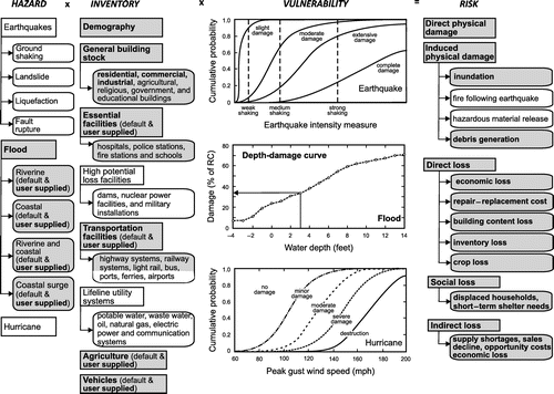
Figure 2 Schematic representation of the hazards, inventory, damage functions, and risks in Hazus. In grey are characteristics of the Hazus Flood model. Characters in bold represent options currently available to Canadian users.
Objectives
The objective of this article is to briefly review the typical features of the Canadian version of the Hazus Flood model and to inform potential users of the developments and challenges of implementing this model in Canada. For detailed description of the Hazus methodology and software the reader is referred to fema.gov/hazus (FEMA Citation2009a, Citation2009b), and to www.hazuscanada.ca for the Canadian application of Hazus.
Flood model
The flood model analyzes riverine flood, coastal flood, and coastal surge hazards (Scawthorn et al. Citation2006a, Citation2006b). The amount of damage and losses that could potentially be incurred by the building stock, infrastructure and population exposed to flood hazard are based primarily upon the depth of the flood water at a given location, although flooding velocity and duration can also be simulated. Other induced hazards associated with flooding include channel erosion and migration, sediment deposition, bridge scour and the impact of flood-born debris (Figure ).
Flood hazard
The flood hazard is determined by the delineated floodplain and the flood depth, defined as the difference between the pre-storm ground surface and the simulated flood surface. In Hazus, there are two available options for the flood hazard definition. The first one involves the determination of the base flood elevation surface with non-Hazus hydraulic models, e.g., Hazus Flood Information Tool (FIT) or the US Army Corps of Engineers (USACE) Hydraulic Engineering Centers River Analysis System (HEC-RAS, hec.usace.army.mil/software/hec-ras/), etc. Subtracting the base flood elevation surface from the terrain elevation yields the flood depth, which is then imported into Hazus as a user-defined flood depth grid. This option is particularly useful for deterministic scenarios or for consideration of historic flood events. The second option is the so-called Hazus Level 1 analysis. It uses embedded processes to compute hydrologic discharge-frequency relationships and to generate maps of floodwater inundation area and depth based on already known/studied main-stem riverine reaches, “out of the box” regression equations and related data, and probabilistic flood hazard scenarios for default return periods (10, 25, 50, 100, and 500 years). The Level 1 hazard analysis will not be included in the ongoing adaptation effort and, for the time being, will not be available to Canadian users. There are several reasons for this decision. First, there is currently no standardized floodplain mapping effort in Canada, and the provincial and local governments manage their own flood damage reduction programs with variable capacity and commitments (https://www.ec.gc.ca/eau-water/default.asp?lang=En&n=0365F5C2-1). In the context of the observed climate changes and often rapid land use changes, the collaborative flood risk maps developed in the 1980s and early 1990s need to be updated frequently, something which cannot be done without considerable implication by all levels of government. Finally, the quality of Level 1 hazard analyses has often been questioned (Ding et al. Citation2008; Neighbors et al. Citation2013), a deficiency which can only be accentuated under the present relatively data-sparse Canadian application context. In the interim, users will still have to develop flood depth grids outside Hazus.
In the case of coastal flood, the input parameters relative to the considered shoreline comprise its extent, severity of wave exposure, type of sediments for erosion assessment, terrain altitudes, and 100-year stillwater elevation. The model then statistically computes the stillwater elevations for return periods of 10, 50, and 500 years as percentages of the 100-year stillwater elevation. The significant wave height is computed by the simplified Wave Height Analysis for Flood Insurance Studies model (WHAFIS), which uses representative transects to compute wave crest elevations in a given study area (http://www.fema.gov/library/viewRecord.do?id=2922).
The coastal storm surge modeling capability integrates two industry standard models: Sea Lake and Overland Surge from Hurricanes (SLOSH, http://slosh.nws.noaa.gov/sloshPub/) and Simulating WAves Nearshore (SWAN, http://www.wldelft.nl/soft/swan/). Both models are partially determined in the hurricane model. Due to the SWAN model’s near-shore inaccuracy, the wave propagation from the shoreline inland is performed in the flood model applying user-provided transects. The wave regeneration, dune erosion and wave runup are not considered in either Hazus coastal or coastal surge models.
Inventory
All Hazus models use common inventory data (i.e., built environment and demographics) to avoid eventual discrepancies when switching from one hazard to another. As is the case with flood hazard definition, Canadian users have two options for inventory definition: a default Hazus inventory database aggregated on a census block level (out of the box inventory), or refined exposure information and supplied local inventory data, where each building is given its own latitude, longitude, construction type, etc. Compared to the aggregated inventory, the local data are also of much better quality with respect to building and content replacement cost, occupancy and square footage.
Hazus Flood uses five basic construction classifications (wood, concrete, steel, masonry and manufactured housing) and seven general occupancy categories (residential, commercial, industrial, agricultural, religious/non-profit, governmental and educational buildings). The relative distribution of occupancies varies by census tract and is computed directly from the specific occupancy class square footage inventory. In addition, the flood model considers essential facilities (hospitals, schools, police and fire stations), selected transportation facilities (highway, light rail and railroad bridges), selected utility facilities (water treatment plants, pumping stations), agriculture products and vehicles (Figure ).
In the vulnerability assessment, the foundation type and its associated typical height are also considered and come together with information for the elevation of the first floor from grade (Figure ). Both have significant impact on the loss estimation. The foundation type can be selected from among the following types with default values of the first floor height in parentheses: pile (7–8 ft), pier (5–6 ft), solid wall (7–8 ft), basement (4 ft), crawlspace (3–4 ft), fill (2 ft) and slab-on-grade (1 ft). In Hazus, “1st floor” refers always to the lowest floor. The number of stories matters too, and is taken into consideration when performing the General Building Stock (GBS) analysis. The database also includes square footage by occupancy, full replacement cost by occupancy, building count by occupancy, and population statistics.
Figure 3 Schematic representation of the hazard parameters for a typical Canadian house with a basement [1st floor in Hazus]. Depth-damage functions are applied to relevant depth of flooding (depth in structure).
![Figure 3 Schematic representation of the hazard parameters for a typical Canadian house with a basement [1st floor in Hazus]. Depth-damage functions are applied to relevant depth of flooding (depth in structure).](/cms/asset/3964b9a5-6221-4575-aa5d-9bfe0b2d8fd2/tcwr_a_801599_f0003_b.gif)
In Hazus Flood, the census block is chosen for aggregation of the General Building Stock; this means that aggregated inventory data are grouped by census block geography. GBS is an inventory category that represents all buildings in specified census geography. A census block is defined by the smallest area enclosed by either administrative (national, province, county) boundaries, shorelines, or natural (creeks, rivers) or man-made centerlines (streets, roads, highways). Based on the analysis of 8.2 million census blocks in the US, the average size of this smallest geographic unit is about 0.9 km2. This, relatively small size justifies the use of census blocks as the basis for computational analyses and aggregation of results. In Canada, however, the current average size of a census block is 164 km2, which exceeds even the average census tract size in the US (116 km2) and greatly exceeds the US average census block size (Table ). To increase the accuracy of the flood results in Canada, the homogeneous census blocks building and content exposure distribution should be further divided into appropriate local neighbourhood-scale. NRCan is currently working with the Hazus Flood programmers to find a potential solution to further refine the census block scale. The latest trend in the use of the dasymetric mapping approach (a thematic cartographic technique that allows using underlying ancillary data to enhance distribution maps) offers a number of advantages (Todorov Citation2012). The existing land use/land cover maps represent an example of supplementary data that could be used for refining the Canadian census block boundaries. The application of the dasymetric distribution approach would bring more accurate flood risk GBS analysis without the cost of collecting user-defined individual building data, their storage and incorporation into Hazus, while still maintaining the processing speed superiority.
Table 1. Census block size in Canada and in the US.
Currently, in terms of built environment and demographics data structure, the Canadian version of Hazus has been modified to reflect the Census Canada geographic boundaries. As in the US, this provides the capability of creating a study region anywhere in Canada based on a geographic, census-based region. In the process of adapting Hazus, a national base inventory layer of residential building information was assembled, providing aggregated information on building square footage, building types and counts, and replacement values for all residential building across Canada. In general, residential buildings represent 85% of the total building stock (Nollet et al. Citation2012). A national demographic distribution layer is provided as well. In Canada, demographic data are collected and distributed by Statistics Canada via the Census Program (www.statscan.gc.ca). These data are updated every five years, and are standardized across the country. It is anticipated that additional asset inventory databases for use in Hazus will be added as they become available, such as commercial and industrial buildings, essential facilities and infrastructure. The integration of the industrial and commercial buildings information into the national Hazus database is underway.
Demographic data are provided at the census block level. So far, local demography information cannot be provided by the user, unless these data are changed within the provincial database.
Damage and loss estimation
Central to the vulnerability modelling is the concept of depth-damage functions defined as plots of floodwater depth versus percent damage. Although damage functions are generated for a specific building of a given type, they can be assumed as reliable predictors of damage for a group of buildings with similar structural characteristics. Examples of depth-damage curves are given in Figures, where the damage expressed as percent replacement cost is directly associated with the flood water depth. The default damage functions stored in the Hazus “damage function library” were developed based on expert opinion, historical damage data and numerical modeling, and have been validated by events in the US. For the GBS and essential facilities, damage functions are available for both structure and contents (assumed in general as 50% of structure value for residential buildings, 100% for commercial buildings, and 150% for industrial buildings and hospitals). In the case of agricultural products, the damage is based on flood depth and duration, and is calculated for the area (percentage) where the floodplain intersects the agricultural region.
In the case of default aggregated inventory data, Hazus Flood performs an area-weighted assessment of damage and losses. This means that each census block is divided into a regular grid, the flood depths are computed for each grid cell, the number of grid cells with a given depth is counted and divided by the total number of cells for that census block, the inventory is assumed evenly distributed across each census block (the percentage of buildings of a given type impacted by given flood depth is equal to the percentage of the census block [number of cells] inundated by that depth), and damage and losses are computed proportionally to the flood depth distribution computed for the census blocks. For example, if 30% of a given census block is flooded with 2 ft of water, 30% of the inventory will be in 2 ft of water. By contrast, the damage for user-defined facilities and essential facilities is determined by the depth of flooding at the location of the facility; thus, if the specific building’s geographic coordinates lie within the inundated area, the proper flood depth at that location will be used by the damage function(s) to calculate damages and losses. An important aspect related to employing Hazus is the use of appropriate damage curves. Hazus allows the user to select among the available damage curves, or to provide damage and loss curves generated for specific building types in the region. The curves currently provided reflect the damage data obtained from post-flood field investigations in the US. Contribution from flood experts and additional research based on damaging flood events will be needed to fully capture and integrate Canadian settings in Hazus.
Standard outputs
The depth-damage curve analysis results in quantitative estimates of the damage to buildings and infrastructure for a given depth. The economic costs are expressed as a percentage of the replacement cost of the structure(s) and converted into estimates of dollar loss. These are the so-called “direct economic losses” related to the immediate physical contact of flood waters with the building. Hazus also estimates additional losses due to the restricted building’s ability to function properly, impacts on the functionality of selected facilities, and dislocations in economic sectors. To account for this, business interruption and rental income losses are estimated as “indirect economic losses”. These losses depend on the amount of time required to restore functionalities and business operations. Hazus Flood also computes the amount of debris generated from the damaged building (finishes and structural components). Direct social losses include displaced households due to loss of housing habitability and short-term shelter needs. Currently, Hazus does not estimate fatalities due to flooding.
Hazus results are presented as visual risk maps, as summary reports with totals for each occupancy class and building type aggregated over the study region, and as tabular results for individual buildings or at census block levels.
Accuracy
Hazus estimates flood risks on the basis of a multitude of input data: asset inventories, depth-damage functions and flood depth grids. As is the case with any other software, the accuracy of Hazus results relies heavily on the quality of the input data, i.e., accurate risk analyses require accurate underlying data. In addition, although risk assessment is essentially a deterministic process, it rapidly becomes probabilistic due to the inherent uncertainty in the input parameters. All these factors can have negative impacts on the accuracy of the final results. The conducted sensitivity analyses indicate that Hazus yields satisfying results and, on average, within one order of magnitude (Gall et al. Citation2007; Ding et al. Citation2008; Merz et al. Citation2010). Thus, it is thus important that the sensitivity and validation of the results be assessed and communicated whenever possible. Given that local data are generally of much better quality, users can overcome eventual deficiencies and improve accuracy by providing more detailed data about their community: upgrading the inventory and flood depth data set, employing higher-resolution digital elevation models, and correcting the depth-damage curves.
Hazus Canada program challenges
Several major challenges face the further implementation of Hazus in Canada. The main challenge is sustaining a long-term program that will update, manage and promote Hazus use in Canada. In the US, FEMA has run the Hazus Program for more than two decades, whereas the ongoing Hazus Canada project coordinated by NRCan and DRDC is in its fourth year. Therefore, it will soon be necessary to assign a working group, ideally among the federal departments involved – Natural Resources, Environment, Defence and Public Safety Canada – to steward the program. In the long term, all the Hazus-related work should be coordinated by a single agency or organization with overall responsibility (Mickey and Coats Citation2012).
Hazus analyses rely on a considerable amount of input data which are critical in achieving accurate risk assessments and helping decision-making to support disaster planning activities. The second important challenge is the development of strategies for collecting, updating and maintaining the input inventory and hazard data. As discussed earlier, Hazus users have the option to choose from the default inventory database aggregated on the census block level, or to refine the exposure and supply local inventory data. Given that local data are generally of much better quality, users are encouraged as much as possible to take advantage of local inventory data. On the other hand, mainly government agencies and academia have traditionally been involved in monitoring and research directed in understanding natural hazards, their specific causes and related processes. Improving the quality of the available data and generating new hazard-related knowledge is key, as is also increasing the accessibility in terms of communications, understanding and integration in local risk assessment studies.
Community participation is recognized as the essential element in disaster management. The active participation of provinces/territories and communities in the risk reduction process should be assured through various forms of incentives. Developing collaborative pilot projects with various levels of government in different regions should contribute in demonstrating Hazus capabilities and benefits. Such examples can help identify gaps and challenges in applying the Hazus methodology in Canada and document required enhancements. A significant output of the pilot studies would be the workflow templates that could be used to guide other communities intending to use Hazus.
Finally, the long-term Canadian Hazus Program should also focus on an effective educational strategy. A variety of traditional methods (classroom courses, conferences, workshops) combined with non-traditional methods (webinars, virtual courses, social media) should be applied in addressing key end-user groups and their needs (Mickey and Coats Citation2012). Lessons learned from the ongoing Hazus education program in the US should also be integrated in the development and maintenance of educational products.
Conclusion
The extreme flood event is the single most frequent natural hazard responsible for economic and social losses in Canada. Flood risk assessment is central to the natural hazard risk reduction process as well as the emergency management planning cycle. Flood risk results are an important means for informed decision-making in terms of pre-disaster planning process and emergency management. On the other hand, it has been recognized that Canadian risk and emergency managers presently lack the necessary standardized tools and guidance to adequately undertake rigorous risk assessments. In the scope of their respective mandates, NRCan has initiated collaboration with the departments of Environment, Defence and Public Safety to adapt and promote widespread usage of the US FEMA’s natural hazard risk assessment tool, Hazus, among the full range of Canadian decision-makers. An agreement with FEMA has been signed for that purpose.
The discussion on sustaining a long-term Canadian Hazus program is underway within the federal government. Adaptation of the Hazus Earthquake model has been accomplished and the flood model is expected to become available in 2013. Hazus will allow communities to become aware of their exposure to natural hazards, and understand the risks, their likelihood and consequences. A better knowledge about the causes and consequences of hazard impacts is, however, only the first step in the long-term process of risk reduction and increasing resilience to natural hazards.
Acknowledgements
The authors wish to thank the NRCan’s Risk Team members, and colleagues from Defence Canada, Public Safety Canada, Environment Canada, US FEMA, and the Polis Center who all contributed so many excellent ideas and suggestions for the ongoing activities. Funding was provided in part through the Chemical, Biological, Radiological-Nuclear and Explosives Research and Technology Initiative, administered by the Defence R&D Canada – Centre for Security Science. The authors would like to thank the Associate Editor and two anonymous reviewers for their valuable comments and suggestions.
Related Research Data
References
- Ding, A., J. F. White, P. W. Ullman, and A. O. Fashokun. 2008. “Evaluation of Hazus-Mh Flood Model with Local Data and Other Program.” Natural Hazards Review 9 : 20–28.
- Federal Emergency Management Agency (FEMA). 2009a. Hazus MH MR4 – Flood Model Technical Manual. Washington, DC: FEMA.
- Federal Emergency Management Agency (FEMA). 2009b. Hazus MH MR4 – Flood Model User Manual. Washington, DC: FEMA.
- Gall, M., B. J. Boruff, and S. L. Cutter. 2007. “Assessing Flood Hazard Zones in the Absence of Digital Floodplain Maps: Comparison of Alternative Approaches.” Natural Hazards Review 8 : 1–12.
- Merz, B., H. Kreibich, R. Schwarze, and A. Thieken. 2010. “Assessment of Economic Flood Damage.” Natural Hazards Earth System Sciences 10 : 1697–1724.
- Mickey, K. J., and D. E. Coats. 2012. The Role of Hazus-MH in the Canadian Natural Disaster Management Strategy. Indianapolis, IN: The Polis Center at Indiana University - Purdue University.
- Neighbors, C. J., E. S. Cochran, Y. Caras, and G. R. Noriega. 2013. “Sensitivity Analysis of FEMA HAZUS Earthquake Model: Case Study from King County, Washington.” Natural Hazards Review 14 (2): 134–146.
- Natural Resources Canada (NRCan), Defence Research Development Canada (DRDC) and Federal Emergency Management Agency (FEMA). 2011. Technical Annex 02 - Adapting Hazus for Risk Assessment of Natural Hazard Threats in Canada. Ottawa: Government of Canada.
- Scawthorn, C., N. Blais, H. Seligson, E. Tate, E. Mifflin, W. Thomas, J. Murphy, and C. Jones. 2006a. “HAZUS-MH Flood Loss Estimation Methodology - I: Overview and Flood Hazard Characterization.” Natural Hazards Review 7 (2): 60–71.
- Scawthorn, C., P. Flores, N. Blais, H. Seligson, E. Tate, S. Chang, E. Mifflin, E. W. Thomas, J. Murphy, C. Jones, and M. Lawrence. 2006b. “HAZUS-MH Flood Loss Estimation Methodology - II: Damage and Loss assessment.” Natural Hazards Review 7 (2): 72–81.